Since the late 1980s, there has been considerable growth in archaeological scholarship on political collapse (Faulseit Reference Faulseit2016; McAnany and Yoffee Reference McAnany and Yoffee2010; Tainter Reference Tainter1988, Reference Tainter2006; Yoffee and Cowgill Reference Yoffee and Cowgill1988). Its initial focus was on understanding why collapse happens and identifying material correlates of collapse (Dever Reference Dever and de Miroschedji1989; Renfrew Reference Renfrew, Renfrew and Cooke1979; Weiss and Bradley Reference Weiss and Bradley2001). More recent scholarship has explored the aftermath of political fragmentation (Chase and Chase Reference Chase, Chase, Demarest, Rice and Rice2004; Conlee Reference Conlee2003; Faulseit Reference Faulseit2012, Reference Faulseit2013, Reference Faulseit2016; Janusek Reference Janusek, Vaughn, Ogburn and Conlee2005; Schwartz and Nichols Reference Schwartz and Nichols2006).
Studies on postcollapse situations in various regional and temporal contexts collectively confirm the importance of differentiating between political fragmentation and cultural collapse. Significantly, considerable continuity is often apparent in the archaeological record after state disintegration (Chase and Chase Reference Chase, Chase, Demarest, Rice and Rice2004; Demarest et al. Reference Demarest, Rice, Rice, Demarest, Rice and Rice2004; Faulseit Reference Faulseit2012; Rice et al. Reference Rice, Demarest, Rice, Demarest, Rice and Rice2004). Cultural continuity is manifested in various ways, including in ceramic forms (Cooper Reference Cooper, Schwartz and Nichols2006), architecture (Chase and Chase Reference Chase, Chase, Demarest, Rice and Rice2004), and agricultural practices (Graffam Reference Graffam1992).
Conlee defines state collapse as “that process in which the political system breaks down and societies become organized on a less complex scale” (Reference Conlee, Schwartz and Nichols2006:99). Both political fragmentation and the continuity in its wake are archaeologically visible for Tiwanaku, one of the earliest states in Andean South America. Tiwanaku exerted political, economic, and cultural influence across large areas of the south-central Andes during the Middle Horizon (AD 500–1000), but postcollapse continuity has been particularly documented in the Moquegua Valley. Located approximately 350 km from the Tiwanaku state capital in the Titicaca Basin, Moquegua was home to the largest Tiwanaku towns outside the heartland. These settlements were established beginning around AD 725 (Goldstein Reference Goldstein2005) and included immigrants from the state center who crafted Tiwanaku-style architecture and portable goods, replicated Tiwanaku practices, and asserted identities rooted in Tiwanaku heritage (Blom Reference Blom1999; Goldstein Reference Goldstein and Aldenderfer1993a, Reference Goldstein1993b, Reference Goldstein2005; Knudson and Price Reference Knudson and Price2007; Sharratt Reference Sharratt2011).
Beginning around AD 950, those towns underwent episodes of destruction and abandonment as the political organization of the wider Tiwanaku state began a process of collapse that was well under way by AD 1000. In Moquegua, a number of smaller villages were established by people fleeing state centers (Owen Reference Owen2005; Owen and Goldstein Reference Owen and Goldstein2001). Practices and materials at these villages exhibit substantial continuity with those at the Tiwanaku towns (Goldstein Reference Goldstein2005; Goldstein and Owen Reference Goldstein and Owen2001; Sharratt Reference Sharratt2016a, Reference Sharratt and Faulseit2016b; Sharratt et al. Reference Sharratt, Williams, Cerna, Starbird, Vranich, Klarich and Stanish2012). Referred to as Tumilaca, terminal Tiwanaku, or terminal Middle Horizon (Goldstein Reference Goldstein, Rice, Stanish and Scarr1989a; Sharratt and Williams Reference Sharratt and Williams2008), the period associated with such continuity has been characterized as short-lived, particularly in comparison with the previous five centuries of regional state influence. In existing models, Tumilaca villages in the Moquegua Valley were completely abandoned by the thirteenth century (Sims Reference Sims, Schwartz and Nichols2006) when Tiwanaku cultural practices were replaced in the archaeological record in Moquegua by new architecture and material styles, termed Estuquiña (Stanish Reference Stanish1991).
New radiocarbon dates from the most extensively investigated terminal Tiwanaku settlement in the Moquegua Valley, Tumilaca la Chimba, raise questions about this time frame. Twenty-one absolute dates derived from excavations in domestic, public, and funerary contexts at the site range from the late tenth to the mid-fourteenth centuries AD, expanding the duration of terminal Tiwanaku occupations in the Moquegua Valley. The earlier dates support existing suggestions that the creation of Tumilaca villages provided part of the impetus for political fragmentation, rather than being a response to state collapse (Owen Reference Owen2005). More striking are the late dates that demonstrate that Tiwanaku-derived practices and materials continued to be salient in the Moquegua Valley longer than previously understood. I propose that the evidence that Tumilaca settlements were inhabited well into the Late Intermediate Period (AD 1000–1470) must be incorporated into ongoing debates about the appearance of Estuquiña communities in the Moquegua Valley.
More broadly, by focusing on Tiwanaku diaspora communities and offering a perspective on the trajectory of political decline in a provincial setting, the dates presented here complement existing archaeological literature on the aftermath of collapse in state cores (Cooper Reference Cooper, Schwartz and Nichols2006; Faulseit Reference Faulseit2012; Graffam Reference Graffam1992; Janusek Reference Janusek, Vaughn, Ogburn and Conlee2005). Moreover, because the reported dates are derived from cemeteries, domestic contexts, and public ceremonial spaces, they provide an opportunity to build on recent cross-cultural literature that emphasizes continuity in the aftermath of collapse by identifying which elements of cultural practice endured.
The Moquegua Valley
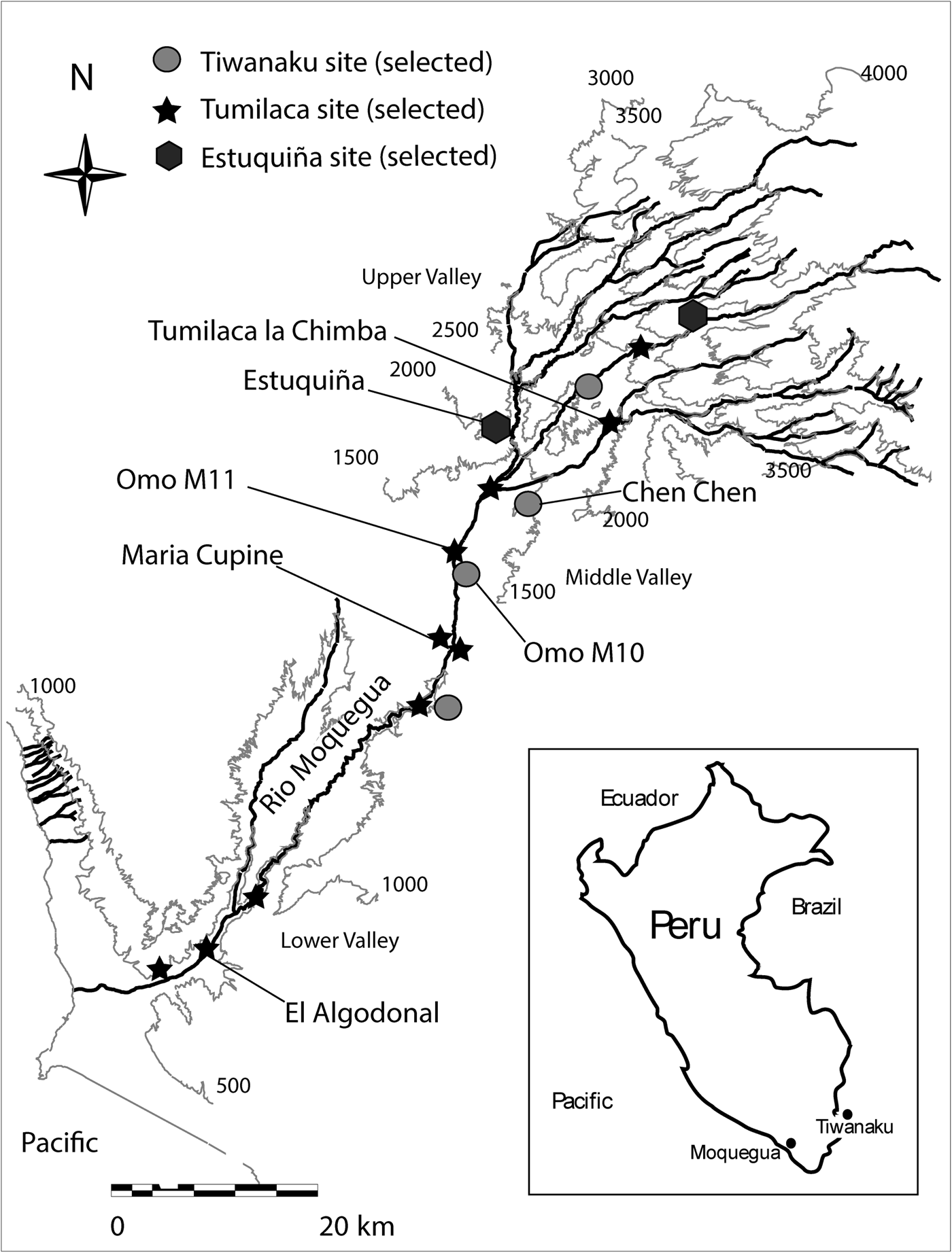
Located in the modern Peruvian department of Moquegua, the Moquegua Valley is divided into three environmental zones (Rice Reference Rice, Rice, Stanish and Scarr1989; see Figure 1). The coastal valley is between sea level and 1,000 m asl. The middle valley, between 1,000 and 1,500 m asl, has a comparatively wide valley bottom overlooked by low hills. The upper valley runs 1,500–3,000 m asl and begins at the confluence of the major river tributaries, the Tumilaca and Torata. The upper valley has steep, rugged topography and is considerably narrower than the middle valley (Williams Reference Williams1997).
Map of selected Tiwanaku, Tumilaca, and Estuquiña sites in the Moquegua Valley.

The Middle Horizon: Tiwanaku Immigrant Communities
Much archaeological work in Moquegua examines the Middle Horizon (AD 500–1000), when state-level political organization was first instituted by Wari and Tiwanaku immigrants who moved there from their respective homelands in the Ayacucho Valley (modern south-central Peru) and the Titicaca Basin (modern Bolivia; Goldstein Reference Goldstein, Vranich and Stanish2013; Williams Reference Williams, Vranich and Stanish2013). The Wari and Tiwanaku largely established authority over different territories in Moquegua, in zones suited to their particular heartland agricultural practices. Wari sites are found in the steep, narrow upper valley that was amenable to major agricultural terracing, irrigation, and hydraulic systems (Nash Reference Nash2002; Williams Reference Williams2002).
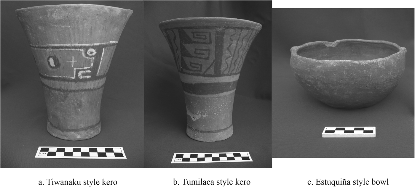
Tiwanaku immigration to the Moquegua Valley is conceptualized as having been undertaken by separate groups of immigrants with different identities but whose presence in the valley overlapped temporally (Goldstein and Owen Reference Goldstein and Owen2001; Owen and Goldstein Reference Owen and Goldstein2001). The earliest Tiwanaku arrivals to Moquegua were pastoralists who occupied ephemeral structures associated with a Tiwanaku ceramic style called Omo; their presence in Moquegua is dated to circa AD 700–1000 (Owen and Goldstein Reference Owen and Goldstein2001). Permanent Tiwanaku settlements (Figure 1), home to thousands of individuals, were constructed by a second wave of immigrants associated with a ceramic style called Chen Chen (Figure 2a), who were present in Moquegua from circa AD 850–1000 (Owen Reference Owen1997; Owen and Goldstein Reference Owen and Goldstein2001). These immigrants were likely attracted by the temperate climate of the valley in which crops, such as maize, that did not grow in the high-altitude Tiwanaku heartland, flourished with irrigation. Sites associated with Chen Chen-style ceramic artifacts are mostly located on hilltop bluffs overlooking the floodplain in the middle valley (Goldstein Reference Goldstein1985, Reference Goldstein, Rice, Stanish and Scarr1989a, Reference Goldstein1989b, Reference Goldstein1993b, Reference Goldstein2005). Analyses of non metric dental and cranial traits and isotope analyses of individuals buried in cemeteries at Omo M10 and Chen Chen confirm that the mortuary populations of these sites included immigrants from the Tiwanaku heartland (Blom Reference Blom1999; Knudson et al. Reference Knudson, Douglas Price, Buikstra and Blom2004; Sutter and Sharratt Reference Sutter and Sharratt2010). Practices, structures, and materials recovered from the Tiwanaku towns in the middle Moquegua Valley largely replicated those from the altiplano and demonstrate a commitment to maintaining heartland ways of life (Goldstein Reference Goldstein1985, Reference Goldstein, Rice, Stanish and Scarr1989a, Reference Goldstein1993b, Reference Goldstein2005).
Tiwanaku, Tumilaca, and Estuquiña pottery from the Moquegua Valley, Peru.

The Terminal Middle Horizon to Early Late Intermediate Period: Postcollapse Tumilaca Villages
Around AD 1000, both the Wari and the Tiwanaku political states began to disintegrate (Janusek Reference Janusek, Vaughn, Ogburn and Conlee2005; Williams Reference Williams2002). The onset of this decline is seen in the Tiwanaku heartland by a cessation in monumental construction (Vranich Reference Vranich2006), abandonment of the urban core (Janusek Reference Janusek2004), destruction of palatial structures (Couture and Sampeck Reference Couture, Sampeck and Kolata2003), and population dispersal into the hinterland (Albarracin-Jordan Reference Albarracin-Jordan1996; Bandy Reference Bandy2001; Stanish Reference Stanish2003). Reevaluating a large number of radiocarbon dates, Augustyniak (Reference Augustyniak2004) dates the end of Tiwanaku in the Titicaca Basin to AD 1060. In long-standing chronologies, state disintegration marks the beginning of the Late Intermediate Period (LIP), a phase associated across much of the Andes with political instability and stylistic localism that endured until the Inka conquest in the fifteenth century (Covey Reference Covey2008). Given the social transformations that occurred across these four centuries as communities responded to state breakdown, endured a period of balkanization, and were then incorporated into an expansive empire, the LIP is often divided into the early and late LIP (Covey Reference Covey2008).
Scholars variously attribute the collapse of the Middle Horizon states to political infighting and revolt, hydraulic overreach, and environmental disaster (Binford et al. Reference Binford, Kolata, Brenner, Janusek, Seddon, Abbott and Curtis1997; Goldstein Reference Goldstein2005; Janusek Reference Janusek2008; Williams Reference Williams2002). In Moquegua, Tiwanaku state collapse is archaeologically marked by processes identified in other examples of political fragmentation, including the destruction of monumental architecture, elite burials, and residential and corporate storage areas (Bermann et al. Reference Bermann, Goldstein, Stanish, Watanabe, Rice, Stanish and Scarr1989; Goldstein Reference Goldstein2005; Tainter Reference Tainter1988; Yoffee and Cowgill Reference Yoffee and Cowgill1988).
A change in settlement patterns is often associated with political collapse. The Tiwanaku immigrant towns in Moquegua were largely abandoned beginning around AD 1000, although limited settlement continued in the middle valley at new sites, for example, Maria Cupine and Omo M11 (Goldstein Reference Goldstein2005). A process of migration that Owen (Reference Owen2005) terms the second Tiwanaku diaspora in Moquegua resulted in settlements in the upper Moquegua Valley and on the coast (Owen Reference Owen2005; Figure 1). Recently, Korpisaari and colleagues (Reference Korpisaari, Oinonen and Chacama2014) presented new radiocarbon dates from the Azapa Valley in northern Chile to propose that Tiwanaku influence there is also more likely a consequence of the political collapse that played out in Moquegua circa AD 1000 than evidence of state incursion during the Middle Horizon. These dates strengthen the evidence for a Tiwanaku-derived presence in the Azapa Valley between AD 1000 and AD 1300 (Cassman Reference Cassman1997).
The settlements established in the middle and upper Moquegua Valley around AD 1000 are called Tumilaca, with those on the coast specifically termed Ilo-Tumilaca/Cabuza (Owen Reference Owen1993, Reference Owen2005). They are considerably smaller than earlier Tiwanaku towns in Moquegua, with a mean habitation area less than 1 ha (Goldstein Reference Goldstein2005). Most Tumilaca settlements were built in previously uninhabited locations and often situated on hilltops (Bawden Reference Bawden and Aldenderfer1993; Bermann et al. Reference Bermann, Goldstein, Stanish, Watanabe, Rice, Stanish and Scarr1989; Owen Reference Owen2005). Defensive walls were constructed around some sites (Goldstein Reference Goldstein2005).
Research at Tumilaca sites indicates substantial continuity in many spheres of life. Tumilaca residential architecture and pottery are similar to earlier styles (Figure 2b; Bawden Reference Bawden, Rice, Stanish and Scarr1989, Reference Bawden and Aldenderfer1993). Notably, Tumilaca ceramic assemblages lack images of the Staff God, thought to be associated with Tiwanaku elite ideology. This absence is indicative of the ongoing process of state rejection (Bermann et al. Reference Bermann, Goldstein, Stanish, Watanabe, Rice, Stanish and Scarr1989; Goldstein Reference Goldstein1985, Reference Goldstein, Rice, Stanish and Scarr1989a, Reference Goldstein2005; Owen Reference Owen1993; Owen and Goldstein Reference Owen and Goldstein2001; Sharratt Reference Sharratt and Faulseit2016b; Sharratt et al. Reference Sharratt, Golitko and Williams2015). Burial practices and domestic rituals were largely maintained by postcollapse communities (Goldstein Reference Goldstein2005; Sharratt Reference Sharratt, Korpisaari and Chacama R2015; Sharratt et al. Reference Sharratt, Williams, Cerna, Starbird, Vranich, Klarich and Stanish2012). Non metric dental trait analysis confirms that the occupants of Tumilaca sites were biologically related to the original Tiwanaku immigrants to Moquegua (Sutter and Sharratt Reference Sutter and Sharratt2010). In sum, although the collapse of the Tiwanaku state represented a major change in regional political organization, substantial forms of cultural and biological continuity are evident in its aftermath.
Existing chronological frameworks, which were largely formulated before the introduction of a calibration curve for the Southern Hemisphere (McCormac et al. Reference McCormac, Reimer, Hogg, Higham, Baillie, Palmer and Stuiver2002), limit the range of Tumilaca to approximately two centuries. Scholars variously propose that the phase dates to AD 950–1200 (Moseley Reference Moseley2001; Sims Reference Sims, Schwartz and Nichols2006; Stanish Reference Stanish1992), AD 900-1000 (Stanish Reference Stanish1991), or AD 950–1050 (Owen Reference Owen2005), with Ilo-Tumilaca/Cabuza on the coast lasting to about AD 1200 (Owen Reference Owen2005). These ranges are based on radiocarbon dates derived from coastal and middle Moquegua Valley sites, including Omo M11, El Algodonal, and Loreto Alto (Goldstein Reference Goldstein2005; Owen Reference Owen1993), but have also been used to establish the temporality of upper valley Tumilaca sites (Sims Reference Sims, Schwartz and Nichols2006; Stanish Reference Stanish, Rice, Stanish and Scarr1989a, Reference Stanish1989b, Reference Stanish1991). In the Azapa Valley, Tiwanaku-derived Loreto Viejo material, which is very similar to Tumilaca, has been dated to just after AD 1300 (Cassman Reference Cassman1997). In sum, Tumilaca sites and materials have been associated with the earlier part of the Late Intermediate Period. Nevertheless, given the considerable maintenance of Tiwanaku styles and practices, these centuries are locally referred to as the terminal Middle Horizon (Sharratt and Williams Reference Sharratt and Williams2008).
The Later Late Intermediate Period: Estuquiña
In contrast to the continuity with Tiwanaku evident at Tumilaca sites, the appearance of Estuquiña architecture and material culture in Moquegua's archaeological record during the latter part of the LIP constitutes a radical change. Estuquiña sites are frequently located on hilltops, and many are fortified. Domestic compounds are larger than Tiwanaku houses in Moquegua and are characterized by different construction practices and layouts of agglutinated rooms (Bawden Reference Bawden, Rice, Stanish and Scarr1989, Reference Bawden and Aldenderfer1993; Conrad Reference Conrad and Aldenderfer1993). Estuquiña pottery is rarely decorated other than a modeled nub on shallow bowls (Figure 2c). Pastes and slips are cruder than those characterizing Tiwanaku and Tumilaca pottery (Lozada Cerna Reference Lozada Cerna1987; Stanish Reference Stanish1991). Some burials were within residential structures, in contrast to only appearing in cemeteries as at Tiwanaku and Tumilaca sites (Burgi et al. Reference Burgi, Williams, Buikstra, Clark, Cerna, Pino, Rice, Stanish and Scarr1989; Williams Reference Williams1990; Williams et al. Reference Williams, Buikstra, Clark, Cerna, Pino, Rice, Stanish and Scarr1989).
The origins of Estuquiña groups are unclear. Comparing architecture at Estuquiña sites in the Otora Valley with that in the Titicaca Basin, Stanish argues that the Estuquiña were likely an autochthonous development in the Moquegua Valley and were not Lupaqa migrants from the altiplano (Stanish Reference Stanish, Rice, Stanish and Scarr1989a, Reference Stanish1989b). The roots of that development, however, are unknown, and scholars note similarities between Estuquiña and Wari agricultural practices (Goldstein Reference Goldstein2005; Williams Reference Williams1997), raising the possibility that descendants of Wari immigrants contributed to this LIP cultural manifestation.
Estuquiña sites are thought to have characterized the upper Moquegua Valley and, to a lesser degree, the middle Moquegua Valley for two to three centuries before Inka conquest circa AD 1470. Excavation data demonstrate that Estuquiña communities endured well into the Late Horizon when the local population was dominated by the Inka Empire (Chacaltana-Cortez Reference Chacaltana-Cortez2015). Conrad (Reference Conrad and Aldenderfer1993) proposes a date range of AD 1200/1300–1500, based on eight radiocarbon dates from two Estuquiña sites in the middle valley.
Scholars debate which calibration curve is most appropriate for different parts of South America (Marsh et al. Reference Marsh, Bruno, Fritz, Baker, Capriles and Hastorf2018). The Southern Hemisphere calibration curve was developed in response to concerns that differences in the amount of atmospheric 14C in the Northern and Southern Hemispheres make the international calibration curve inappropriate for the Southern Hemisphere (McCormac et al. Reference McCormac, Reimer, Hogg, Higham, Baillie, Palmer and Stuiver2002). Recent archaeological work in the Andes uses the Southern Hemisphere calibration curve (Koons and Alex Reference Koons and Alex2014; Korpisaari et al. Reference Korpisaari, Oinonen and Chacama2014; Levine and Stanish Reference Levine and Stanish2013), the most recent version of which is SHCal13 (Hogg et al. Reference Hogg, Hua, Blackwell, Niu, Buck, Guilderson, Heaton, Palmer, Reimer, Reimer, Turney and Zimmerman2013). In response to concerns that the possible mixture of air from the Northern Hemisphere might undermine its applicability in tropical South America (Ogburn Reference Ogburn2012), Marsh and colleagues (Reference Marsh, Bruno, Fritz, Baker, Capriles and Hastorf2018) address the applicability of the IntCal curve, the SHCal curve, or a mixed calibration curve for different parts of South America. They conclude that the IntCal curve is appropriate only for northern South America, which is little affected by Southern Hemisphere air in any season. Marsh and colleagues' example of dates from Lake Titicaca falls within the part of South America for which a mixed calibration curve is most appropriate. For dates derived from the Tiwanaku heartland, in the Titicaca Basin, a mixed curve would be used. Because I discuss material derived from archaeological contexts in the Moquegua Valley, outside that part of South America, I use the SHCal13 calibration curve.
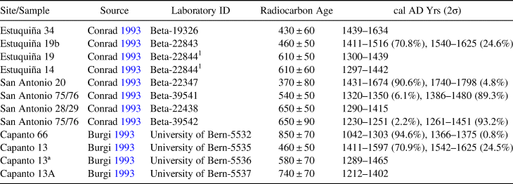
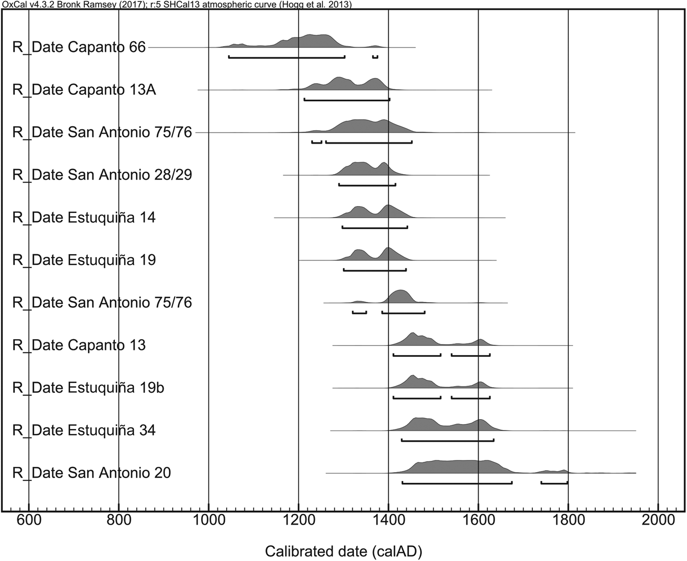
Recalibration produces dates from the late thirteenth to the sixteenth centuries at the site of Estuquiña and the mid-thirteenth to the seventeenth centuries at the site of San Antonio (Table 1; Figure 3). Recalibration of dates from the upper valley Estuquiña site of Capanto (Burgi Reference Burgi1993) suggest that Estuquiña occupation began earlier in the upper reaches of the Moquegua Valley, with the earliest date (2σ) from the site cal AD 1042–1303.
Recalibrated (SHCal13 2σ) Radiocarbon Dates from Estuquiña Sites in the Moquegua Valley, Peru.

1 In Conrad Reference Conrad and Aldenderfer1993, the laboratory ID Beta-22844 is attributed to the radiocarbon dates from both Estuquiña 19 and from Estuquiña 14.
Calibrated (SHCal13 2σ) radiocarbon dates from Estuquiña sites in the Moquegua Valley, Peru. Dates published in Burgi Reference Burgi1993; Conrad Reference Conrad and Aldenderfer1993.

Although persuasive challenges (Rice Reference Rice1993) have been made to Rowe's influential temporal model (Rowe Reference Rowe1962; Willey Reference Willey1991), the notion that the Andean past was characterized by periods of widespread stylistic uniformity and political unity (horizons) interspersed by regional stylistic diversity and political instability (intermediate periods) remains strong in archaeological research in the Andes. In Moquegua, ongoing research on the Tumilaca communities established around the time of Tiwanaku state fragmentation explores the nebulous cultural-historical processes of the transition from the Middle Horizon to the Late Intermediate Period. Based on radiocarbon dates from the middle Moquegua Valley, Tumilaca is understood to have been comparatively short-lived, enduring for about two centuries. Recent radiocarbon dates derived from research at one upper valley Tumilaca site suggest that, at least there, postcollapse continuity and the legacy of Tiwanaku lasted longer.
Tumilaca la Chimba
Located approximately 15 km up valley from Tiwanaku towns in the middle Moquegua Valley (Figure 1), Tumilaca la Chimba is a village situated at 1,900 m asl overlooking the Rio Tumilaca. First established during the resettlement process associated with the abandonment of Tiwanaku towns (Owen Reference Owen2005), the site, the object of significant recent research, has had two occupations. The first is associated with architecture constructed of double-faced foundation walls made of small, regular, neatly aligned stones held together with mortar. This architecture is very similar to that at neighboring terminal Middle Horizon sites (Sims Reference Sims, Schwartz and Nichols2006). Tumilaca-style pottery is ubiquitous in these structures. Estuquiña-style pottery, associated with the second occupation, is found in the large rectangular and trapezoidal structures of the later LIP style; they are built of single-faced walls consisting of irregularly sized and arranged stones located on the eastern side of the site.
The Tumilaca occupation is associated with four cemeteries on slopes above the village that lead to the summit of Cerro La Chimba, where an Estuquiña-style fortification was constructed. Comparison of non metric dental traits from individuals buried in the Tumilaca cemeteries with individuals buried at the Tiwanaku town of Chen Chen demonstrate that the populations share an ancestor–descendant relationship (Sutter and Sharratt Reference Sutter and Sharratt2010), substantiating the suggestion that Tumilaca la Chimba was first inhabited by descendants of the original Tiwanaku migrants to Moquegua.
A History of Research at Tumilaca la Chimba
The earliest archaeological research at Tumilaca la Chimba concentrated on one of the Tumilaca cemeteries and recovered Tumilaca-style ceramic vessels from 14 intact tombs (Pari Flores Reference Pari Flores1980). In the early 1980s, researchers from the binational archaeological research collective “Programa Contisuyo” mapped the site. They conducted small test excavations that demonstrated that the Estuquiña structures are built on top of some Tumilaca buildings (Bawden Reference Bawden, Rice, Stanish and Scarr1989). Later, Owen (Reference Owen1996) included the site in his survey of the upper valley.
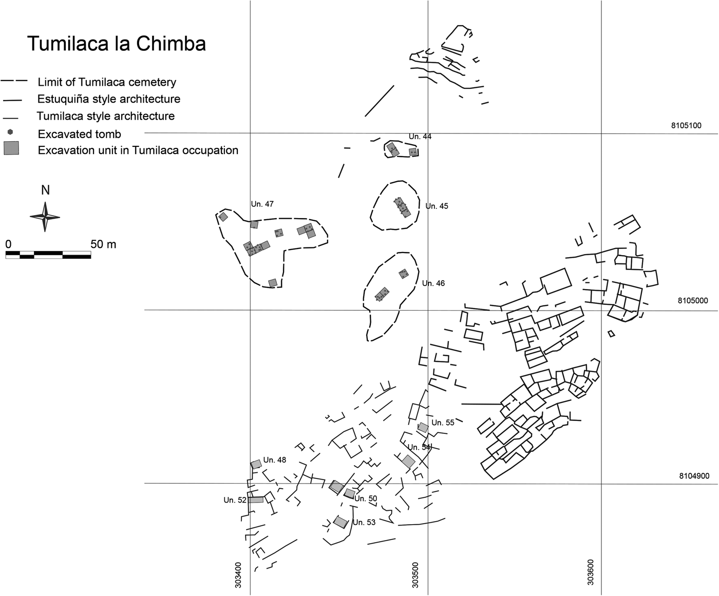
Agricultural activity in the early 2000s threatened the site, and rescue excavations undertaken in response initiated the most recent research: four excavation seasons between 2006 and 2012 in the terminal Middle Horizon occupation (Figure 4) and two (2015, 2016) examining the LIP settlement (Parker and Sharratt Reference Parker and Sharratt2017). In this article, I focus on radiocarbon dates derived from the terminal Middle Horizon occupation.
Map of Tumilaca la Chimba indicating excavation units in terminal Middle Horizon contexts.

2006–2012 Excavations at Tumilaca la Chimba
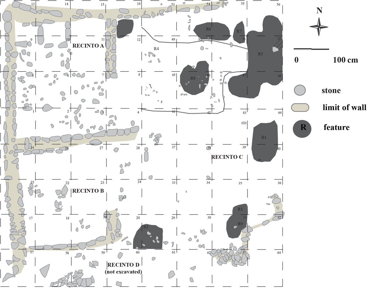
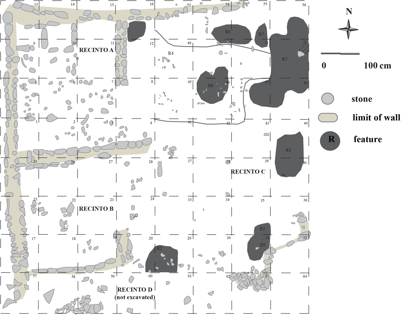
Excavations in the terminal Middle Horizon settlement at Tumilaca la Chimba sought to examine the impact of Tiwanaku collapse on daily life, lived experience, ritual practice, identity construction, and participation in economic networks. Research revealed considerable continuity from the height of Tiwanaku state authority in the Moquegua Valley. The complete horizontal excavation of five domestic compounds demonstrated that the routines of daily life were maintained in the wake of collapse (Sharratt Reference Sharratt, Korpisaari and Chacama R2015). The standard domestic architectural pattern at Tumilaca la Chimba is a two-roomed structure that opens onto a patio whose spatial extent (24–32 m2) is approximately equivalent to the interior space (Figure 5). Deviations from this pattern include one-roomed houses and at least one larger multistructure domestic unit. Interior rooms were used for storage and sleeping, whereas external patios were used for food production, trash disposal, and crafting activities.
Unit 48, Tumilaca la Chimba, a domestic structure characterized by two rooms and associated patio.
The excavated material culture is very similar to Tiwanaku material, although visual analysis reveals greater diversity in size and form, as well as “poorer” execution of decoration (Sharratt Reference Sharratt and Faulseit2016b). Compositional data derived from LA-ICP-MS (laser ablation inductively coupled plasa mass spectrometry) analyses of ceramic material demonstrate greater chemical heterogeneity in pottery at Tumilaca la Chimba than in assemblages from Tiwanaku towns (Sharratt et al. Reference Sharratt, Golitko and Williams2015). Visual and compositional analyses also suggest that craft production may have shifted from centralized workshops in the earlier state towns (Goldstein Reference Goldstein2005) to smaller-scale, possibly household, production in the collapse-phase villages. Comparison of the ICP-MS data with a compositional database of Moquegua Valley clays (Sharratt et al. Reference Sharratt, Golitko, Williams and Dussubieux2009) indicates that the terminal Middle Horizon community at Tumilaca la Chimba had reduced access to nonlocal pottery compared with that at the height of the Tiwanaku state (Sharratt et al. Reference Sharratt, Golitko and Williams2015). Regional political decline thus affected participation in long-distance economic networks (Sharratt Reference Sharratt and Faulseit2016b).
Cultural continuity with Tiwanaku is also evident in ritual practice at Tumilaca la Chimba. Excavation of 64 burials across the four cemeteries revealed cemetery organization, tomb types, body preparation, and grave inclusions similar to practices at Tiwanaku towns (Sharratt et al. Reference Sharratt, Williams, Cerna, Starbird, Vranich, Klarich and Stanish2012). Public ceremonial practice took place in a large (20 × 6 m) nondomestic structure (Unit 54) in the middle of the village. There, the community engaged in practices— making subfloor offerings of ritually significant vessels, smashing pottery, and possibly venerating standing monuments—akin to those documented in ceremonial space at Tiwanaku towns including those in Moquegua (Goldstein Reference Goldstein1993b). In contrast to monumental structures associated with state-sponsored ideology, collective ceremonial practice at Tumilaca la Chimba was conducted in accessible, unimposing rustic space, a shift associated with rejection of the elite appropriation of religious ideology (Sharratt Reference Sharratt2016a).
In sum, data derived from excavations in the terminal Middle Horizon occupation at Tumilaca la Chimba suggest a community that maintained an ongoing affiliation with Tiwanaku cultural practices and that expressed an altiplano heritage. Owen (Reference Owen2005) understands this ongoing assertion of an identity rooted in the Titicaca Basin homeland and in the Moquegua Tiwanaku migrant population, despite the physical distance from the altiplano and the punctuated violence associated with abandonment of towns like Chen Chen and dispersal up valley, as a second-stage diaspora (Cohen Reference Cohen1997). Yet, the community at Tumilaca la Chimba also felt the economic effects of an altered regional political context and elected to reject or resituate some components of Tiwanaku practice.
Given the radiocarbon dates derived from excavations at Tumilaca la Chimba, I propose that the terminal Middle Horizon settlement at the site endured later than was earlier suggested. In the next section I explore the implications these data have for current understandings of Tiwanaku state fragmentation, for conceptualizing the Late Intermediate Period in the south-central Andes, and for cross-cultural understandings of the aftermath of collapse.
Dating the Terminal Middle Horizon Occupation at Tumilaca la Chimba
As discussed, the literature suggests that the Tumilaca phase in the Moquegua Valley was relatively brief and that Tiwanaku-associated communities were gone before the establishment of Estuquiña-style settlements in the second half of the LIP. Twenty-one radiocarbon dates derived from the 2006–2012 excavations of terminal Middle Horizon contexts at Tumilaca la Chimba expand the chronological range of the site.
Samples and Analysis
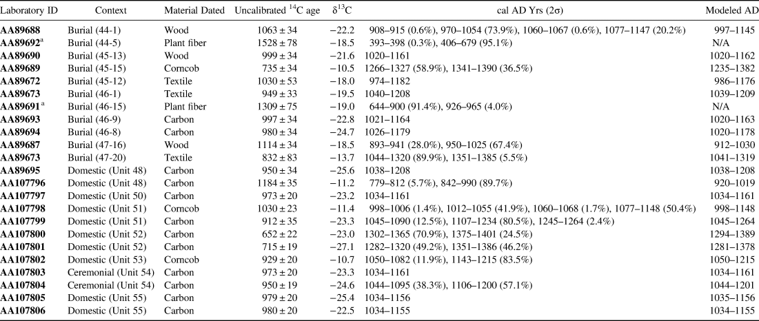
The 21 dates are derived from materials excavated from the four terminal Middle Horizon cemeteries (n = 9), four domestic structures (n = 10), and the rustic public ceremonial structure located in the middle of the village (n = 2). The upper Moquegua Valley is sufficiently arid that botanic and organic materials are recovered during excavations at Tumilaca la Chimba. The 21 radiocarbon dates are derived from samples of carbonized material (n = 12), corncobs (n = 3), wood (n = 3), and textile fragments (n = 3). Samples were submitted for analysis at the University of Arizona AMS laboratory and calibrated using the OxCal v4.3.2 program with the SHCal13 calibration curve (Hogg et al. Reference Hogg, Hua, Blackwell, Niu, Buck, Guilderson, Heaton, Palmer, Reimer, Reimer, Turney and Zimmerman2013), which is more appropriate for the Moquegua Valley than the IntCal or mixed calibration curve (Marsh et al. Reference Marsh, Bruno, Fritz, Baker, Capriles and Hastorf2018). The use of the OxCal v4.3.2 program also ensures comparability with recently reported late Tiwanaku radiocarbon dates from the Azapa Valley (Korpisaari et al. Reference Korpisaari, Oinonen and Chacama2014). Dates reported here are calibrated 2σ (Table 2). Additionally, Bayesian statistical modeling was performed using OxCal v4.3.2 to refine dates and generate start and end dates for the Tumilaca phase at Tumilaca la Chimba (Bronk Ramsey Reference Bronk Ramsey2009).
Calibrated (SHCal13 2σ) and Modeled Radiocarbon Dates from Terminal Middle Horizon Occupations at Tumilaca la Chimba.
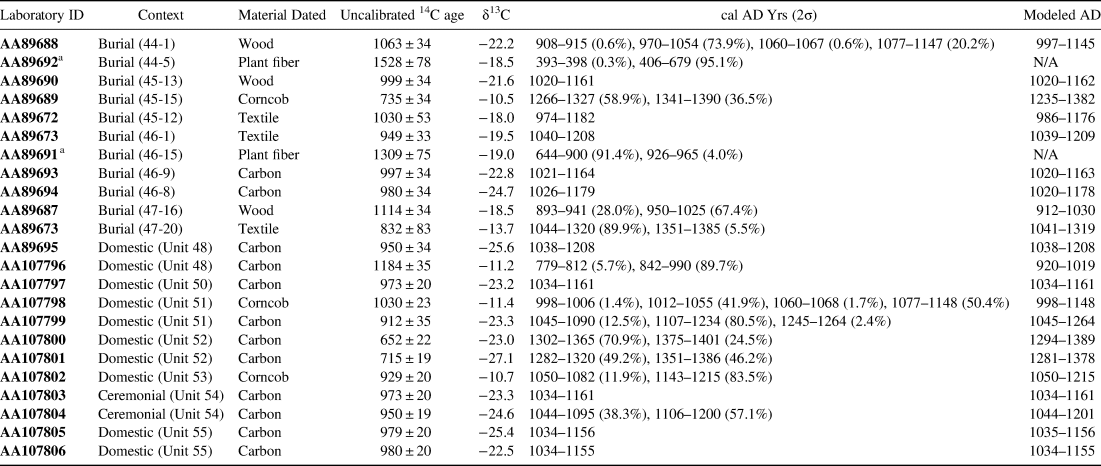
a Presumed anomalous.
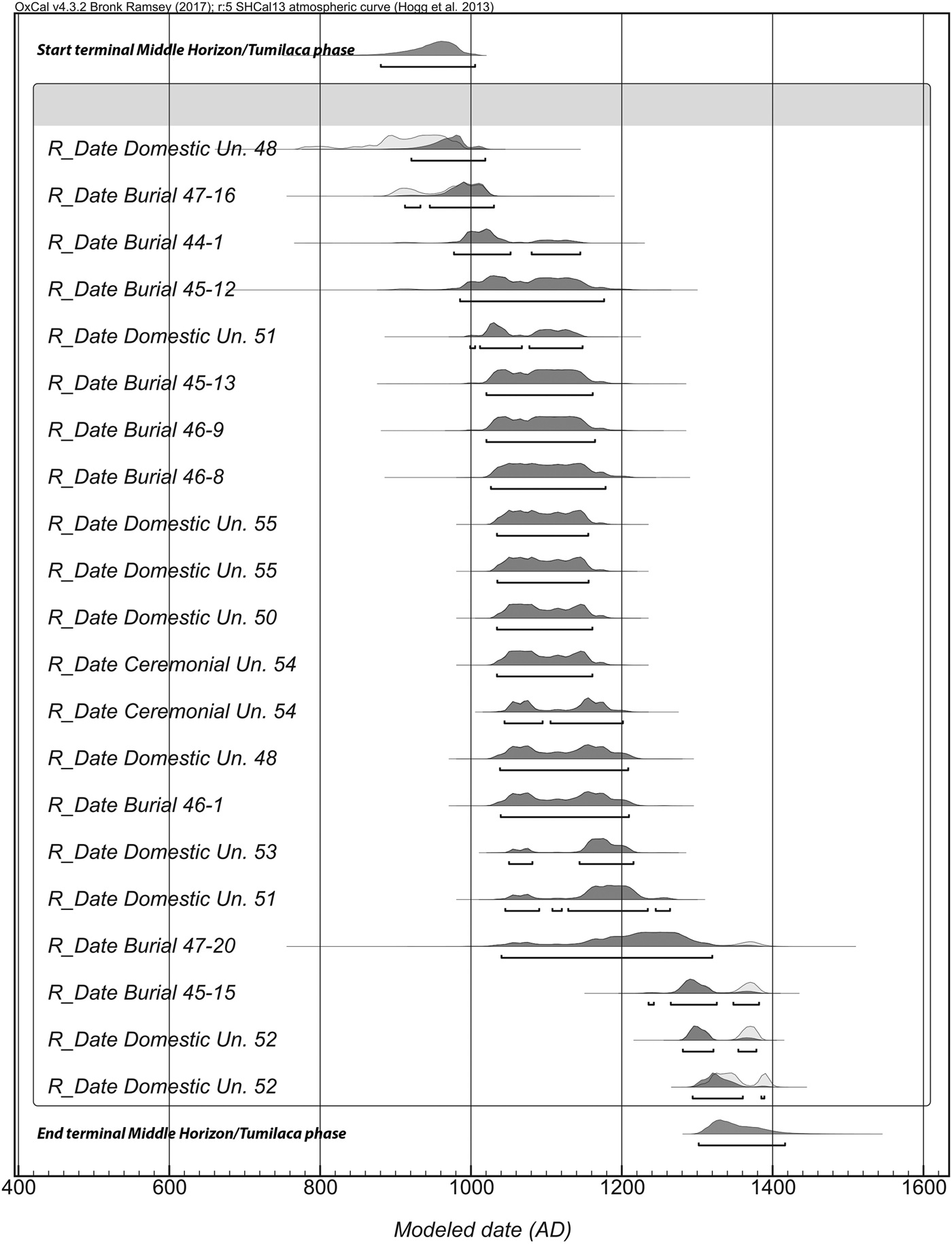
Two additional samples of braided rope, made of plant fiber and used to hold Tiwanaku mummy bundles in position in graves, were also dated. Both produced unexpectedly early dates. One, from cemetery 46, resulted in a date of cal AD 644–965. The other, from cemetery 44, produced a date of cal AD 393–679, which predates the arrival of the Tiwanaku people and their cultural traits in the middle Moquegua Valley. When included in the phase analysis, these two dates derived from fiber rope produced an agreement index of <25%. In contrast, the other 21 dates all had agreement indices of around 99%. Given this disparity and the one particularly early date produced from one of the fiber rope samples, it is possible that this material produced anomalous dates. Although detailed in Table 2, these two dates are excluded from the following discussion and from Figure 6, which illustrates individual modeled dates, as well as the modeled start and end dates, for the Tumilaca phase occupation at Tumilaca la Chimba.
Calibrated (SHCal13 2σ) radiocarbon dates and phase analysis from terminal Middle Horizon occupations at Tumilaca la Chimba. Samples calibrated individually are shown in gray, with the Bayesian model in black.

Results
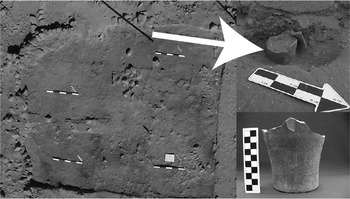
Most of the 21 dates are concentrated between AD 1000 and 1200, suggesting that the terminal Middle Horizon occupation of Tumilaca la Chimba was most intensive during these centuries (Figure 6). Six of the dates in this time period are derived from the Tumilaca-style cemeteries, and seven are derived from domestic contexts. The two dates from the rustic public ceremonial structure also cluster tightly within this two-century period: one, derived from the use surface of the structure, dates to cal AD 1034–1161 (AA107803), and the second, derived from a subfloor offering of a kero, dates to cal AD 1044–1201 (AA107804; Figure 7).
Offering of kero in the floor of a ceremonial structure (Unit 54).

Nevertheless, both the Tumilaca-style cemeteries and domestic structures produced earlier dates. A sample from the burial of an adult male in cemetery 47 (on the western slope of Cerro La Chimba) produced a date of cal AD 893–1025 (AA89687), with a modeled date of AD 912–1030. The dated sample was wood, so its early date could be attributed to its being old wood. More persuasive is a sample of carbonized material in a trash pit located in the exterior patio associated with a two-room domestic structure (Unit 48). This dated to cal AD 779–990 (AA107796), with a modeled date of AD 920–1019. The δ13C value for that sample is -11.2, typical of C4 plants including maize, which is arguably less likely than wood to have been left unburned for a long time, and therefore provides stronger evidence for a pre-AD 1000 occupation at Tumilaca la Chimba.
A date derived from a large hearth located within a porch area of the same domestic space was within the expected two-century range at cal AD 1038–1208 (AA89695), suggesting that, even if the domestic unit's occupation began before AD 1000, it endured well into the twelfth century. When calibrated, both of these earlier dates had bimodal distributions (Table 2; Figure 6). Each had a greater probability of dating to the tenth century than to the eighth or ninth century. The starting point for the Tumilaca phase is therefore not radically altered but possibly may be a little earlier than previously thought.
More striking are the dates that indicate that the terminal Middle Horizon occupation continued later than accounted for by existing chronological models. These are derived from the cemeteries and domestic contexts. Another burial of an adult male in cemetery 47 produced a date of cal AD 1044–1385 (AA89673) and a modeled date of AD 1041–1319. On the other slope of Cerro La Chimba, in cemetery 45, a date derived from a corncob found in the burial (tomb 45–15) of an adolescent of undetermined sex was cal AD 1266–1390 (AA89689), modeled to AD 1235–1382. The two other dates from cemetery 45 were cal AD 1020–1161 (AA89690), modeled AD 1020–1162, and cal AD 974–1182 (AA89672), modeled AD 986–1186, which were from the burials of a juvenile and a child, respectively.
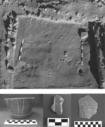
The latest dates from the terminal Middle Horizon occupation at Tumilaca la Chimba are derived from a domestic structure located on the same ridge as Unit 48. Although the structure is of more rustic construction than Unit 48 and consists of only one room with an associated exterior patio, its low double-faced walls are recognizably Tumilaca, and the unit is surrounded by a number of other structures associated with the terminal Middle Horizon occupation. Diagnostic pottery, including a tazon buried upside down in a subfloor offering, recovered from the floor and features, are stylistically Tumilaca (Figure 8). One carbon sample, derived from the compact surface of this structure, was dated to cal AD 1302–1401 (AA107800), with a modeled date of AD 1294–1389. A second, derived from a hearth in the exterior patio, dated to cal AD 1282–1386 (AA107801) and had a modeled date of AD 1281–1378. The difference in δ13C values between these two dated carbon samples from Unit 52 makes it unlikely that they derive from the same piece of wood.
Unit 52, showing double-faced walls and Tumilaca style ceramics recovered from the floor and features.

The phase analysis produces a start date to the terminal Middle Horizon occupation at Tumilaca la Chimba of AD 881–1006 and an end date of AD 1301–1415 (Figure 6). Bayesian modeling, which is increasingly used to refine chronologies by narrowing error ranges (Overholtzer Reference Overholtzer2015), had little impact on the majority of dates but did slightly refine the earliest and latest dates, namely those most relevant to this article (see Table 2 and Figure 6).
Discussion
The phase analysis and individual dates from Tumilaca la Chimba suggest the reconsideration of existing chronological models for the terminal Middle Horizon in the upper Moquegua Valley. The village was likely first established in the mid- to late tenth century, when Tiwanaku immigrant towns such as Omo M10 and Chen Chen were still populated (Augustyniak Reference Augustyniak2004; Goldstein Reference Goldstein2005; Sharratt Reference Sharratt2011). Although occupation at Tumilaca la Chimba and Tiwanaku towns probably overlapped slightly, the absence in the former site's ceramic collection of imagery associated with state ideology supports the idea that this community rejected elite-affiliated iconography (Sharratt Reference Sharratt and Faulseit2016b). These early radiocarbon dates highlight a complex process in which some residents of state towns began to vote with their feet, establishing new communities as the Tiwanaku towns declined (Owen Reference Owen2005). In so doing, these residents both responded to and contributed to the collapse of elite authority in the middle valley.
The later dates are more striking and suggest that cultural practices derived from Tiwanaku remained salient in Moquegua considerably later than previously proposed. As discussed, existing chronologies for Tumilaca were largely constructed before development of a calibration curve for the Southern Hemisphere. Differences between earlier date ranges and the phase analysis presented here are likely in part a consequence of the use of SHCal instead of IntCal. In particular, the IntCal curve results in calibrated dates that are slightly earlier than those produced with the SHCal curve (Marsh et al. Reference Marsh, Bruno, Fritz, Baker, Capriles and Hastorf2018). For example, with the SHCal curve sample AA107796 was calibrated to AD 779–990, with a modeled date of AD 920–1019. Using the IntCal curve, the same date is calibrated to AD 721–965, with a modeled date of AD 728–970. Whereas Marsh and colleagues’ (Reference Marsh, Bruno, Fritz, Baker, Capriles and Hastorf2018) recent publication supports the use of the SHCal curve for the Moquegua Valley, the effect of different calibration curves is significant and must be considered in refinements to local chronologies.
Nonetheless, the dates from Tumilaca la Chimba raise significant points of discussion for the Moquegua Valley, for the south-central Andes post-AD 1000, and for anthropological models of the aftermath of political collapse. Owen (Reference Owen2005) suggests that Ilo-Tumilaca/Cabuza, the coastal manifestation of postcollapse Tiwanaku, endured later than did middle valley Tumilaca occupations, whereas Cassman (Reference Cassman1997) dates Loreto Viejo, a Tiwanaku-derived style found in northern Chile, to slightly after AD 1300. Owen's and Cassman's findings, coupled with the dates from Tumilaca la Chimba, raise the possibility that the communities who moved farther away from the original Tiwanaku immigrant towns endured longer than those communities that settled close by. This possibility merits further consideration. Additionally, systematic comparison of Tumilaca communities established in different ecological zones and in varying degrees of proximity to the original Tiwanaku settlements has the potential to shed light on regional sociopolitical dynamics after political fragmentation.
Tumilaca la Chimba has a second occupation characterized by Estuquiña architecture and materials. The Estuquiña settlement is concentrated on the eastern side of the site, where it superimposes Tumilaca buildings. Radiocarbon dates from the Estuquiña occupation at Tumilaca la Chimba are pending, but recalibrated published dates from other Estuquiña sites place their establishment in the thirteenth century (Burgi Reference Burgi1993; Conrad Reference Conrad and Aldenderfer1993). If the Estuquiña settlement at Tumilaca la Chimba was also established by or during the thirteenth century, then it would have overlapped, at least briefly, with the later Tumilaca contexts.
These data challenge existing understandings of Moquegua's culture history, which hold that Tumilaca villages were abandoned before the construction of Estuquiña sites. Ongoing analyses examining the biological and cultural relationship between the Tumilaca and Estuquiña populations at Tumilaca la Chimba will contribute to debates about the origins of Estuquiña populations. In the meantime, the likely temporal overlap between occupations at Tumilaca la Chimba suggests that reconstructions of the overall trajectory of the Late Intermediate Period in Moquegua should take Tumilaca populations into consideration.
This overlap is also relevant when considering the particular Tumilaca contexts from which dates derived. Although I emphasize earlier and later dates, the majority of dates from the Tumilaca la Chimba suggest that the Tumilaca occupation of the site was at its height between AD 1000 and 1200. Moreover, domestic contexts, cemeteries, and public ceremonial space were all in use during this time. Later dates, those from the thirteenth and possibly fourteenth centuries, were only derived from domestic and funerary contexts. The collective ritual structure at Tumilaca la Chimba had fallen out of use by the thirteenth century. Thus, although Tiwanaku cultural practices endured past AD 1200, it is possible that after this time they were only performed in private domestic or intimate funerary settings.
The maintenance of Tiwanaku practices in familial and intimate settings at Tumilaca la Chimba into the fourteenth century, despite the abandonment of collective ritual space at the site around AD 1200, is arguably related to the establishment of the Estuquiña village and the changes that took place in Moquegua during the Late Intermediate Period: this narrative gains credibility by examining more closely the domestic context from which the latest Tumilaca dates derived. Unit 52 was the most rustic Tumilaca structure excavated at Tumilaca la Chimba. Located on the western side of the site (the area that lacks Estuquiña architecture) in the most exposed part of the domestic sector and on the ridge of a hill, it lacks internal spatial differentiation and exhibits poor quality construction. I tentatively suggest that, as Estuquiña materials became prominent on the site, a small group of villagers in the least attractive area of the site maintained Tiwanaku-derived traditions within their homes and in their funerary rituals.
Beyond the Andes, the trajectory of the Tumilaca-style occupation at Tumilaca la Chimba is relevant for scholars of collapse. First, it supports recent scholarship that recognizes political fragmentation as a gradual process (Conlee Reference Conlee, Schwartz and Nichols2006; Demarest et al. Reference Demarest, Rice, Rice, Demarest, Rice and Rice2004; Rice et al. Reference Rice, Demarest, Rice, Demarest, Rice and Rice2004). Tiwanaku, as a phenomenon, did not come to a sudden and uniform end. Rather, communities such as Tumilaca la Chimba maintained Tiwanaku practices and styles for as much as three centuries after the political structure began to break down and, in so doing, asserted that Tiwanaku was not defined by elite authority.
Second, the data presented here offer insight into the postcollapse dynamics of peripheral communities, complementing work on the aftermath of collapse that concentrates on ancient state centers. In the Tiwanaku heartland, dates derived from burials at Tiraska provide a comparison with Tumilaca la Chimba. Tiraska is associated with the political decline of the state, but ceramic artifacts exhibit clear continuity with Tiwanaku styles (Korpisaari Reference Korpisaari2006). Nine radiocarbon dates published by Korpisaari (Reference Korpisaari2006) were recalibrated using the mixed calibration curve, in line with Marsh and colleagues’ (Reference Marsh, Bruno, Fritz, Baker, Capriles and Hastorf2018) recommendations for the altiplano. When calibrated 2σ, only one (Hela-66, calibrated AD 1050–1265) of the nine dates suggests that the cemetery could have been in use after AD 1200. The other dates have calibrated ranges that end before AD 1200. Additional data from the heartland and other peripheral locations would facilitate exploring whether cultural expressions derived from Tiwanaku endured longer in the provinces than the core.
Finally, the dates presented here not only highlight the substantial continuity frequently seen after political collapse (Chase and Chase Reference Chase, Chase, Demarest, Rice and Rice2004; Graffam Reference Graffam1992) but also provide an opportunity to reconstruct the specifics of continuity. Comparison of dates from post-Tiwanaku mortuary, domestic, and public ceremonial contexts at one site demonstrates that attempts to identify continuity in practice or style can be productively enhanced by considering context. Although the gradual restriction of Tiwanaku materials and practices at Tumilaca la Chimba to residential space may partly be a consequence of the emergence of Estuquiña communities in Moquegua, the clear maintenance of precollapse traditions in domestic and intimate funerary contexts some 150 years after the abandonment of assertions of Tiwanaku heritage in public space should spur comparative investigation into the venues and media in which postcollapse continuity is manifested.
Conclusion
Over the past several decades, anthropological archaeologists, including those working in Andean South America, have paid increasing attention to the decline of states. As elsewhere, this work has revealed considerable cultural continuity despite political fragmentation. The Tumilaca communities established in the Moquegua Valley as the Tiwanaku state's regional political authority broke down are an example of this cultural continuity, although to date Tumilaca has been understood as a relatively short-lived manifestation that emerged as a consequence of state collapse. The radiocarbon dates derived from comprehensive excavations of one Tumilaca village both indicate that cultural influence from Tiwanaku, at least in Moquegua, endured at least three centuries after its political fragmentation began and provide context for teasing out the social continuities and changes that played out during the transition from the Middle Horizon to the Late Intermediate Period.
Acknowledgments
Excavations at Tumilaca la Chimba were supported by the National Science Foundation (BSC 1347166 & DDIG 0937303), the National Geographic Society (9096-12), the Archaeological Institute of America, the Curtiss T. and Mary G. Brennan Foundation, and Dumbarton Oaks. Additional support was provided by the Graduate College and Department of Anthropology at the University of Illinois at Chicago. Excavations were conducted with permission from the Ministerio de Cultura del Perú, Lima (RDN 1208/INC; RDN 1350/INC; RDN 301-2012; RDN 24-2015). The radiocarbon dates were generated by the Arizona Accelerator Mass Spectrometry (AMS) Laboratory at the University of Arizona. Thanks to the Tumilaca la Chimba excavation crews, the Museo Contisuyo, and my colleagues, especially P. Ryan Williams. Lizette Alda Muñoz and Breidy Quispe Vilcahuaman translated the abstract of this paper into Spanish. Thanks also to the anonymous reviewers. Any errors or oversights are mine alone.
Data Availability Statement
Materials excavated at Tumilaca la Chimba are stored at the Museo Contisuyo, Moquegua, Peru. The original hard copy, digital field records, and photographs are in the possession of the author at Georgia State University.