Archaeological studies in the area located between the Chico and Grande rivers in northern Tierra del Fuego (Argentina, Figure 1a) have increased during the last decade. The systematic survey of the area has resulted in an improved scenario for the distribution of the archaeological record (Oría Reference Oría, Salemme, Santiago, Alvarez, Piana, Vázquez and Mansur2009, Reference Oría2012; Oría, Salemme, and Santiago Reference Oría, Salemme and Santiago2010; Oría, Salemme, Santiago, and Montes Reference Oría, Salemme, Santiago and Montes2010; Salemme and Bujalesky Reference Salemme, Bujalesky, Belardi, Marina and Espinosa2000; Salemme et al. Reference Salemme, Bujalesky, Santiago, Morello, Martinic, Prieto and Bahamonde2007; Santiago Reference Santiago2010, Reference Santiago2013; Santiago, Bujalesky, and Salemme Reference Santiago, Bujalesky, Salemme, Morello, Martinic, Prieto and Bahamonde2007; Santiago, Oría, and Salemme Reference Santiago, Oría and Salemme2007).
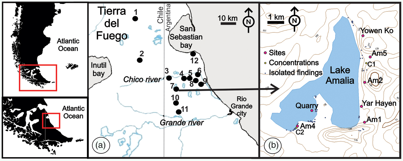
Location map. (a) Study area. Location of archaeological sites or localities mentioned in the text. References: 1- Miraflores; 2- Tres Arroyos; 3- Río Chico 2 and 3; 4- Perro; 5- Las Vueltas; 6- Río Chico 1; 7- Amalia; 8- Avilés, Herradura, and Pozo Tierra del Fuego; 9- La Arcillosa 2; 10- Arturo; 11- Tres Marías; 12- Los Chorrillos. (b) Archaeological record in Lake Amalia.

In this area of the Fuegian steppe, shallow, salty lakes abound. The basin morphology of some of these lakes evidenced higher water volumes in the past (Coronato et al. Reference Coronato, Llopiz, Ponce, Villarreal and López2012); consequently, salinity may have been lower than it is today. These lakes could have functioned as aggregating loci for human groups, as suggested by the archaeological signal (Oría Reference Oría and Mena2016). Useful resources from lagoons and lakes, such as guanacos (Lama guanicoe), birds, water, and lithic raw materials, are concentrated around the lake shorelines. The seasonal regime may have made these lakes relatively unstable for predictable resources such as water and fauna, but important during dry periods due to the availability of rocks suitable for knapping. Erosion processes have exposed glaciofluvial gravels and boulders. As a result, these lakes supplied lithic resources in two sections: some gravel-rich deposits on the higher levels of the steep coast and over the dry lake bottom. Both gravels and boulders might have been used for artifact manufacture (see e.g., Oría Reference Oría, Salemme, Santiago, Alvarez, Piana, Vázquez and Mansur2009, Reference Oría2012; Santiago, Bujalesky and Salemme Reference Santiago, Bujalesky, Salemme, Morello, Martinic, Prieto and Bahamonde2007).
More than a dozen shallow lakes were surveyed, each one considered an archaeological locality. Lake Amalia shows a singular record composed of at least seven sites (Figure 1b), two concentrations of materials, and numerous isolated findings. This is solid evidence of human use during the Holocene; we interpret that there was a preference for this shallow lake given the reoccupation of the locality (Oría Reference Oría and Mena2016). A noted feature in Lake Amalia is the use of lithic raw material. Cores and flakes typical of the first manufacturing stages are ubiquitous in the higher sectors, as shown in the Yar Hayen site (Oría and Pal Reference Oría and Pal2010, Reference Oría and Pal2011), located in a steep coast overlooking the lake (Figure 1b). Evidence recovered from the site points to the primary use of cobbles. The size of the cobbles recorded here differs from the materials often recorded in the region.
In this study we explore a possible explanation of the reoccupation of this locality. The hypothesis points out that the distribution of lithic raw materials—the availability of boulders of certain types and/or sizes—influenced human occupation in the area. While the survey carried out at the bottom of Lake Amalia and a sampling of its shoreline sectors showed extended patches where pebble and cobble size coincide with those employed as raw materials by hunter-gatherers in the region, certain points of the lake, such as the Yar Hayen site, offer different kinds of boulders.
Environmental Setting, Resources and Archaeological Visibility
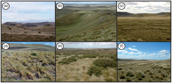
The Fuegian steppe in the northern sector of the Isla Grande de Tierra del Fuego (Figure 2a, b, c) extends from the Magellan strait to the low hills of Viamonte Cape, south of the Grande river (Cabrera Reference Cabrera1976; Collado Reference Collado, Godoy Manríquez and Paileleo2007; Coronato Reference Coronato, Godoy Manríquez and Paileleo2007). The climate is cold-temperate, with oceanic influence, and annual rainfall ranges between 300 and 350 mm (Cogliati and Cuello Reference Cogliati, Cuello, Godoy Manríquez and Paileleo2007; Coronato Reference Coronato, Godoy Manríquez and Paileleo2007). Such low precipitation, an average annual temperature of 5.5 °C, and a persistent and strong wind regime generate poor conditions for water preservation in summer (Iturraspe and Urciolo Reference Iturraspe and Urciuolo2002, Reference Iturraspe, Urciuolo, Godoy Manríquez and Paileleo2007). Persistent west-northwest winds generate a dry effect in summer and cool temperatures in winter. The annual mean wind speed is 23 km/h, though it can occasionally reach 140 km/h, particularly in the spring and summer seasons (Iturraspe and Urciolo Reference Iturraspe, Urciuolo, Godoy Manríquez and Paileleo2007).
Fuegian steppe environment. (a), (b), and (c): landscape; (d), (e), and (f): detail of the cover vegetation where Festuca gracillima dominates. Photos by Jimena Oría.

The area is marked by numerous deflation hollows defined as “pans” (Villarreal and Coronato Reference Villarreal, Coronato and Rabassa2017), formed in dry lands mainly as a result of aeolian deflation. Most of these pans are the depositional centers of endorheic basins that receive short and ephemeral streams. In some periods many of them sustain a shallow lake, locally affected by wave action as a consequence of permanent and intense action of the western winds. This generates significant erosion in the eastern coastal areas (Villarreal and Coronato Reference Villarreal, Coronato and Rabassa2017).
Local vegetation is characterized by herbaceous steppe flora, including Festuca gracillima (Figure 2d) and Empetrum rubrum. In some sectors, shrubs of Chilliotrichum diffusum are also present (Figure 2e, f). Grasslands or meadows develop along the streams, due to more humid conditions (Collado Reference Collado, Godoy Manríquez and Paileleo2007). From a physiographical viewpoint, this sector of the island is influenced by several geomorphological and environmental factors:
• low ranges and hills, with altitudes up to 300 m asl
• low-density channel network
• alternated events of flooding and desiccation of river channels and lake basins
• steppe vegetation
• low temperature and precipitation, with strong winds
• soil types developed from sandy materials, unfavorable for a dense vegetation cover
• freezing soils
All of these factors, in addition to the trampling and herding, lead to unstable conditions in certain surface sections, giving rise to hollows or hydro-aeolian depressions. This surface denudation, however, increases archaeological visibility, which is otherwise quite low along the Fuegian steppe (see Figure 2). Altogether, these conditions result in a differential preservation of the record.
A look upon the present landscape shows little variation; however, hunter-gatherer populations that inhabited the steppe at different moments of the Holocene used to have a solid knowledge (sensu Rockman Reference Rockman, Rockman and Steele2003) of the location and spatial distribution of significant resources, including water, wood, lithic raw materials, fauna, and shelterFootnote 1.
From a regional perspective, lithic raw materials (the topic of this article) were extracted from secondary sources, primarily inland glaciofluvial deposits and/or gravels that are available in different environments of the island. The distribution of raw material has been described as “heterogeneous” for the San Sebastián bay (Figure 1a) area. Although access to cobbles might have been limited to a few sectors of the marine coast to the south of the bay (Franco and Borrero Reference Franco, Borrero, Aschero, Korstanje and Vuoto1999), there are large areas of several square kilometers where cobbles are completely absent, particularly along the northern bay coast (Borrazzo Reference Borrazzo2010, Reference Borrazzo, Oría and Tivoli2014).
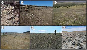
At the inland area, nearby Lake Amalia, the raw material sources are glaciofluvial deposits (Figure 3). Gravel deposits are recorded in diverse points of the landscape. Even though gravel levels do not yield continuous exposure, outcrops are not too distant, and there are no known limitations to accessibility. As opposed to the heterogeneity proposed for the sea coast, inland lithic raw materials are an available resource used in the past (see Santiago, Bujalesky, and Salemme Reference Santiago, Bujalesky, Salemme, Morello, Martinic, Prieto and Bahamonde2007). Consequently, this resource should not be considered as scarce or of limited accessibility.
Lithic raw material at a regional level. (a) stratigraphic position of cobbles used for knapping; (b), (c), and (d): gravel outcrops; (d) and (e) boulders in different sectors of southern (d) and eastern (e) coasts of Lake Amalia; (f): cobbles in the dry bottom of Lake Arturo. Photos by Jimena Oría.

Theoretical Framework
Distributional archaeology and landscape ecology (Dunnell and Dancey Reference Dunnell and Dancey1983; Foley Reference Foley1981; Stafford and Hajic Reference Stafford, Hajic, Rossignol and Wandsnider1992) are suitable approaches for the study of archaeological finds of this sector in the Fuegian steppe (Belardi Reference Belardi2005; Belardi and García Reference Belardi and García1994; Belardi et al. Reference Belardi, Fernanda García, Campan and Borrero1998; Borrero and Lanata Reference Borrero, Lanata, Borrero and Lanata1992). Relatively continuous, though low in density, surface records and limited stratified contexts are often described in the area (Oría Reference Oría2012; Santiago Reference Santiago2010; and bibliography cited there).
Regarding this issue, Stafford (Reference Stafford1995) focused on the theoretical relationship between geomorphological analysis and models explaining the links between settlement patterns and landscape structure. Landscape ecology considers landscape structure as the way its elements are arranged, defining these elements as discrete ecosystems that represent a space in which an attribute—landform, soil, vegetation, etc.—is homogeneous (Stafford Reference Stafford1995; Stafford and Hajic Reference Stafford, Hajic, Rossignol and Wandsnider1992). The distribution of these elements in the landscape could have influenced hunter-gatherers’ mobility strategies. Similarly, their frequency and spatial distribution would have conditioned space-use patterns and, at least partially, the spatial arrangement or structure of the archaeological record (Stafford Reference Stafford1995).
Distributional archaeology is suitable for the model presented here in terms of the spatial scale and analysis of the archaeological record of a whole region rather than individual sites (Schlanger Reference Schlanger, Rossignol and Wandsnider1992). In fact, distributional studies that encourage the artifact as the analytical unit (i.e., nonsite archaeology, Dunnell and Dancey Reference Dunnell and Dancey1983; Foley Reference Foley1981; Thomas Reference Thomas and Mueller1975) provide a clear view of the structure at the regional level. From this perspective, the archaeological record was categorized as isolated findings, concentrations and sites based on the density of recorded artifacts sensu Borrero and colleagues (Reference Borrero, Lanata, Ventura, Borrero and Lanata1992). The analysis of variations in artifact density reveals the relationship between the structure of the archaeological record and certain elements of the landscape, such as lakes (shallow lakes, in this case), hills, river plains, etc.
Additionally, Schlanger (Reference Schlanger, Rossignol and Wandsnider1992) coined the term “persistent place,” a concept defined as a place repeatedly used for a long time on a regional scale. The integration of isolated findings, minor concentrations, and sites highlights the potential of the archaeological record to analyze space use and reuse during long-term occupations. This focus broadens the scale of the analysis, including not only the individual loci, but also the isolated findings and minor concentrations scattered along a locality such as Amalia. This theoretical framework supports the idea that past populations organized recurrent visits to this locality or to a particular sector of it, where raw material and faunal resources were available.
Several occupation episodes are recorded in many of the sites in the area: (a) Tres Arroyos 1 rock shelter yielded the earliest human occupation for Tierra del Fuego, circa 10,500 14C years BP (Massone Reference Massone2010; Massone and Prieto Reference Massone and Prieto2004; Massone et al. Reference Massone, Alfredo Prieto, Gabriel Cárdenas and Cárdenas1999), as well as late Holocene and historical times’ records in the upper levels. (b) Discrete superimposed occupations in shell middens were dated between circa 5500 and 3200 14C years BP (Morello et al. Reference Morello, Borrero, Torres, Massone, Arroyo, McCulloch, Calas, Lucero, Martínez, Bahamonde, Salemme, Santiago, Álvarez, Piana, Vázquez and Mansur2009; Prieto et al. Reference Prieto, Elisa Calás and Torres2007; Salemme and Santiago Reference Salemme, Santiago, Vázquez, Elkin and Oría2017; Salemme, Santiago and Oría Reference Salemme, Santiago and Oría2014; Salemme et al. Reference Salemme, Bujalesky, Santiago, Morello, Martinic, Prieto and Bahamonde2007; Santiago Reference Santiago2013; Santiago, Oría, and Salemme Reference Santiago, Oría and Salemme2007). (c) A large number of archaeological sites were radiocarbon dated to the last two millennia, suggesting a significant demographic growth during this period. As stated by Morello and others (Reference Morello, Borrero, Massone, Stern, García-Herbst, McCulloch, Arroyo-Kalin, Calás, Torres, Prieto, Martínez, Bahamonde and Cárdenas2012:76), “Redundancy and reoccupation in the use of sites is frequent, and all the available environments on the island appear to be occupied.” Until absolute dating is available, two chronological alternatives may be considered to interpret the record at Lake Amalia: (a) a “long count” for human presence at the Fuegian steppe (ca. 10,500 BP), or (b) a more probable occupation scenario dated to the middle and late Holocene.
Radiocarbon dates were obtained from interbedded soil, ash, and aeolian sequences at other lakes: Arturo (Coronato, Fanning et al. Reference Coronato, Patricia Fanning, Jimena Oría and Ponce2011; Coronato, Salemme et al. Reference Coronato, Salemme, Moretto, Oría, Ponce, Orgeira, Onorato, Vásquez, Osterrieth, Fernández, Laprida and Benvenuto2011); O'Connor (Oría, Villarreal et al. Reference Oría, Villarreal, Coronato, Salemme and López2014); Las Vueltas 1, and Perro (Santiago Reference Santiago2013; Santiago and Salemme Reference Santiago and Salemme2016). These offer a chronological framework that contributes to the archaeological picture for the area, though the provenience of dated remains is sometimes hard to identify. In Lake Amalia, several edaphized levels were dated; the first is in Amalia 4, on the southern coast of the lake, that directly overlies tertiary substrate (3020 ± 60 years 14C BP - LP-3068; Oría [Reference Oría and Mena2016]; Oría, Villareal et al. [Reference Oría, Villarreal, Coronato, Salemme and López2014]), the second in Amalia 5, located on the eastern coast (360 ± 30 years 14C BP - Beta-346885; Oría [Reference Oría and Mena2016]; Oría, Villarreal et al. [Reference Oría, Villarreal, Coronato, Salemme and López2014]). In Amalia 6, radiocarbon dates obtained from edaphized levels suggest climate amelioration and stabilization of the surfaces, in at least nine opportunities since the middle Holocene (ca. 5000 years BP; Coronato et al. Reference Coronato, Mónica Salemme and Mari2017). This shows that, at least in some sectors of the lake, early Holocene sediment was either not deposited or not preserved; this may point to a relatively later age for occupation of this locality.
Material and Methods
The materials were recorded following alternative methodologies. Isolated findings and concentrations of materials were recorded in situ using GPS, while sites were surveyed with a total station (Pentax 326). Both lithic and bone remains were measured and collected. Following Borrero and colleagues (Reference Borrero, Lanata, Ventura, Borrero and Lanata1992), “isolated finding” refers to a unique artifact not linked to other findings within a circle 20 m in diameter, “concentration” or “low-density scatters” refer to 2 to 24 artifacts within a circle 20 m in diameter, and “site” refers to 24 or more artifacts in a circle 20 m or more in diameter.
Lithic material dominates the collections and is the focus of this contribution. It was analyzed following proposals by Aschero (Reference Aschero1975, Reference Aschero1983), and Orquera and Piana (Reference Orquera and Piana1986). The following variables were considered: artifact category, raw material, dimensions (length, width and thickness in mm), size (using a box grid with size categories defined by 5 mm intervals, sensu Franco Reference Franco2002), weight in grams, and amount of cortex on surface (measured in percentage: 0% or total absence, 25%, 50%, 75%, and 100%). Cores, flakes, debris, and tools, especially scrapers, bola stones, and projectile points, were identified in the technomorphological analysis.
The study of cores followed Paulides’ (Reference Paulides and de Micou2006) methodology and considered core type and shape, minimal number of flakes removed, platform type (natural or prepared), and reduction state (exhausted or unfinished). The maximum linear dimension (MLD) (sensu Andrefsky Reference Andrefsky1998:139) was estimated for the size of cores—that is, the maximum length of a core multiplied by its weight, which gives a uniform measurement of size.
Raw material was macroscopically identified, using broad lithological categories of rock groups (Borrazzo Reference Borrazzo2010) instead of thin sections. Finally, the spatial analysis of the record recovered at Lake Amalia was based on the interpretation provided by Shuttle Radar Terrain Mission S54W69.hgt, in Global Mapper 10, free version.
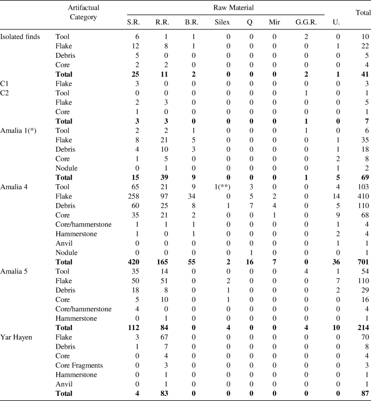
This article exclusively analyzes the lithic material from a number of contexts in the Amalia archaeological locality (Table 1 and Figure 1b). It includes some isolated findings (N = 41); 2 concentrations of materials: C1 (N = 7) and C2 (N = 3); and 7 sites: Amalia 1 (N = 69), Amalia 2 (located but not collected; Santiago Reference Santiago2013), Amalia 4 (N = 701), Amalia 5 (partially sampled, N = 214), Yar Hayen (N = 87) and Yowen Ko (the excavation of 6 m2 yielded mainly bone remains and a unique flake). Finally, several knapped cobbles were found at the bottom of the lake, in an area identified as Amalia Quarry. This context remains under analysis.
Lithic Record of the Amalia Locality.

Reference: S.R.: silicified rocks; R.R.: rhyolithic rocks; B.R.: basaltic rocks; Q: quartz; Mir: Miraflores; G.G.R.: coarse-grained rocks; U.: unidentified. (*) taken from Santiago Reference Santiago2013. (**) a projectile point of green obsidian (Oría, Salemme, and Santiago Reference Oría, Salemme and Santiago2010) is grouped with other silex instruments to simplify the table.
The focus for this analysis is Yar Hayen, the first surface context interpreted as a workshop site in the area. Only lithic artifacts were recovered, including mainly cores, debris, a hammerstone, and an anvil. Remains may have been generated in one or more knapping events, as suggested by the medium-high integrity of the sample that is inferred from its technological coherence as much as the limited displacement of the pieces and their refitting (Oría and Pal Reference Oría and Pal2011).
Table 1 lists the whole lithic record known so far from the Amalia locality. Additionally, the lithic record published for the area, particularly cores (in terms of dimensions and weight), is reviewed in order to discuss aspects related to stone transport. The less frequent archaeofaunal remains from Amalia locality were also recorded. A detailed analysis is presented in Oría, Salemme, and Vázquez (Reference Oría, Salemme and Vázquez2016).
Results
The frequency and distribution of isolated findings in the Lake Amalia area is related to the peculiar conditions of the local environment (see Environmental setting) because deflation hollows and gullies are unquestionably “open windows” for archaeological visibility (Davis and Holdaway Reference Davies and Holdaway2017). Furthermore, artifact discard rate contributes to increased record visibility in this locality. The inferred recurrent visits (Oría Reference Oría and Mena2016; Oría, Salemme, and Fernández Reference Oría, Salemme and Fernández2014) are here reviewed with the goal of identifying landscape aspects that could have functioned as “pull factors” (Rockman Reference Rockman, Rockman and Steele2003). In this sense, lithic resource availability is one of the possible factors. This lake area may have supplied boulders for knapping. Raw material of certain specific characteristics could have been collected there. As shown in Table 1, in almost all contexts of the locality are cobbles with evidence of knapping. Supplemental Table 1 summarizes the different types of cores described in sites Amalia 4 and 5.
The Yar Hayen site presents particular characteristics that deserve special attention. It lies on a tertiary substrate in a cliff to the east of the lake (Figures 1b). Materials were scattered over approximately 80 m2 but heavily concentrated in just 19 m2. The boundaries of the site were identified by the absence of archaeological remains (Oría and Pal Reference Oría and Pal2011).
The sample contains 87 lithic artifacts including 78 pieces of debris (89.7%), 7 cores (8.1%), 1 hammerstone (1.1%), and 1 anvil (1.1%). The best represented raw material is rhyolite (98.9%), and only 1 flake was knapped on a still-unidentified rock. Seven types of rhyolites are macroscopically identified according to grain size, color, and silicification level (Oría and Pal Reference Oría and Pal2011). The presence of cores and the abundance of flakes with cortex (either primary or secondary), together with the absence of retouched artifacts, characterize the site as a workshop where local raw materials were knapped. The high percentage of flakes that correspond to primary reduction activities (plane, natural, and cortical striking platforms are identified) reinforces this hypothesis. Furthermore, pecked and crushing evidence detected on the anvil and a fracture on the hammerstone suggest that they were used for tool manufacturing in the Yar Hayen site.
In order to determine the integrity and resolution of the surface collection, we considered the material distribution and refitting (Oría and Pal Reference Oría and Pal2011). The former takes into account the relations manifested between variables at the artifact level (artifact categories, weight and raw material) and topographic features (presence of slope and channels).
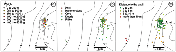
The weight was examined to estimate the displacement or relocation of materials. Hence, heavier items yielded a grouped pattern, integrating dense concentrations (Figure 4a). Distribution of artifact categories can be related to the knapping activities taking place at the site, according to technomorphological analysis, refitting, and alteration of lithic surfaces (Oría Reference Oría2012; Oría and Pal Reference Oría and Pal2011). Cores show a less-dispersed structure than debris (Figure 4b), coinciding with their weight. Flakes and debris present the most dispersed patterns.
Schemes of the artifactual distribution in the Yar Hayen site. (a) distribution by weight; (b) distribution by artifactual categories; (c) distance to the anvil.

Distance was measured from each item to the anvil, because it is the heaviest piece in the sample (Figure 4c). More than half the collection (66%) presented a dispersion of less than 2 m from the anvil, and 91% of the sample was found not further than 5 m away. The grouping of anvil, hammerstone, cores, and flakes/debris could have been originated by knapping activities—particularly the initial reduction stage—in a working area, with a second intention of obtaining blanks to be transported. Experimental studies have demonstrated that flake dropping could reach 4 m during a knapping event (Bowers et al. Reference Bowers, Bonnichsen and Hoch1983 in Kligmann Reference Kligmann and Otero1996; Newcomer and Sieveking Reference Newcomer and Sieveking1980 in Kligmann Reference Kligmann and Otero1996).
Refitting analysis (Bellelli and Kligmann Reference Bellelli and Kligmann1993) at the Yar Hayen site defined three sets:
• Core-debris: 5 units were refitted from 30 items.
• Debris-debris: 6 units refitted from 13 debris fragments.
• Tool-debris: anvil refitted with a small flake.
In total, 57.2% of the items from the Yar Hayen refit.
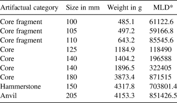
Cores were only basically shaped; they show numerous percussion platforms that indicate discontinuous and irregular knapping. Curiously, people left or abandoned them even if they were still useful. Direct and anvil-based core reduction techniques were used, conditioned by the specific shape and size of the nodules (Oría and Pal Reference Oría and Pal2011). Similarly, the large size and weight of the sole hammerstone and the anvil (more than 4 kg each, Table 2) would have made them highly difficult to transport but adequate to knap artifacts at the source area. These core exploitation strategies produced very large and thick flakes in the first knapping stages. Likewise, a large number of medium but very thick internal flakes indicated the continuity of the manufacturing process at the site.
Size and Weight of Cores, Hammerstone, and Anvil from the Yar Hayen Site.

Reference: * Maximum Linear Dimension.
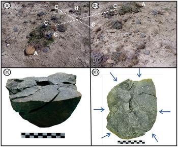
After a refitting analysis, the items classified as cores or core fragments were grouped into four units. A further artifact is a cobble knapped through bipolar technique; it was refitted from two flakes previously classified as bipolar debris. The total sum of these “4 refitted cores” (Figure 5) produced lithic masses weighing 1436.1 g, 1199.9 g, 2550.12 g, and 9002.57 g, respectively. The latter is composed of 16 pieces, two of them identified as cores themselves. The volume and weight reached by this refitted boulder raises two questions: (a) the availability of this kind of resources in the area; and (b) their exploitation in situ or transportation to other sites for a variety of activities. In this regard, we explore the available record of cores at the regional level, analyzing core frequencies in other sites as well as the kind and size of cobbles and pebbles used as raw material.
Core refitting in the Yar Hayen site. (a) and (b): two views of the site when recorded (C: core, A: anvil, H: hammerstone; pointed lines show the same cores from different perspectives); (c): one of the cores refitted; (d): interpretation of the knapping techniques. Photos by Jimena Oría

Discussion: The Regional Scale
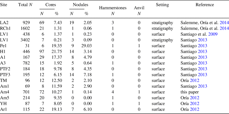
A significant database has been compiled in recent years (Oría Reference Oría2012; Santiago Reference Santiago2010) reflecting the spatial distribution and characteristics of the archaeological record from the area between the Chico and Grande river basins (Northern Tierra del Fuego, Argentina). Santiago (Reference Santiago2010) described the lithic contexts from nine sites either in stratigraphy or on the surface: La Arcillosa 2 (LA2), Río Chico 1 (RCh1), Las Vueltas 1 (LV1), Perro 1 (Pe1), Herradura 1 (H1), Avilés 1 and 3 (A1 and A3), and Pozo Tierra del Fuego 2 and 3 (PTF2 and PTF3; Figure 1a). Core frequencies vary widely at these sites (Table 3) and are better represented at Pe1, H1 and A1.
Frequency of Cores, Hammerstone, and Anvil from Sites in the Study Area.

Recorded cores and nodules, sometimes tested or used as hammerstones, show relatively high frequencies and sizes directly linked to the sources of raw material exploited (oval glaciofluvial cobbles smaller than 150 mm at their maximum axes). They were portable pieces that could be easily replaced; cobbles are readily available.
LV1, located in the eastern coast of Lake Las Vueltas, was reoccupied at least three times during the late Holocene. It is interpreted as a kill and butchering site, where the main prey were guanacos (Santiago and Salemme Reference Santiago and Salemme2016). Cores seem to have been obtained from pebbles collected in the glaciofluvial deposits close to the site, next to the lake shoreline (Santiago et al. Reference Santiago, Pal and Salemme2009), but there is no reference to their size. As expected, due to the interpreted functionality of LV1, there is a low representation of cores and a very high frequency of debris (Santiago Reference Santiago2013); this is typical of task places where edges have to be constantly retouched (Binford Reference Binford1978). In Lake Las Vueltas, archaeological evidence of workshop or quarry is absent. Its classification as a specific hunting place without incidence in lithic raw material acquisition practices is acceptable.
In the case of the surface sites Pe1, H1, A1, A3, PTF2, and PTF3, mentioned by Santiago (Reference Santiago2013), cobble cores are well represented. The most frequent shapes are amorphous, bipolar, and globular cores. In the Pe1 site, a hammerstone and an anvil were also recovered; the anvil, however, could have been used for marrow extraction (Santiago Reference Santiago2013). Bipolar technology is well represented in the H1 site, in terms of cores and nodules; most of them were tested and discarded because of bad quality or the presence of internal flaws. Although there is no reference to cobble size, it seems clear that they were transported into the site and tested there. These cores’ types differed from those recorded in Lake Amalia (Supplemental Table 1). In the sites Amalia 4 and 5 the “tested nodule” type is not the most representative.
Similar characteristics of Pe1 offered the record from A1, A3, PTF2, and PTF3 sites. At A1 there is solid evidence of the bipolar technique, whereas the high rate of cortex in the pieces from the other three sites is a consequence of a reduced number of flakes knapped from each core (Santiago Reference Santiago2013). At the PTF3 site, nodules were reduced through bipolar percussion, and both rough and retouched edges were used. No information about nodule weight and size was published.
The LA2 and RCh1 sites are both stratified shell middens dated ca. 5000 14C years BP (Salemme, Oría et al. Reference Salemme, Jimena Oría and Turnes2014; Salemme, Santiago, and Oría Reference Salemme, Santiago and Oría2014; Santiago, Oría, and Salemme Reference Santiago, Oría and Salemme2007). Both sites are located in the ancient sea shoreline of the middle Holocene. The former, close to the shallow Lake La Arcillosa, not only yielded lithic items but also abundant faunal remains of vertebrates and invertebrates. They were interpreted as campsites.
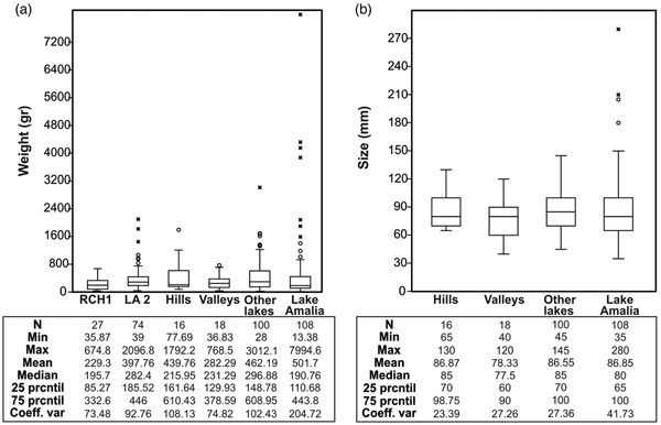
The lithic collection from the LA2 site consists of 929 pieces (Salemme, Oría et al. Reference Salemme, Jimena Oría and Turnes2014). At RCh1, the total number of lithic items amounted for 1602 (Table 3). Refitting was possible for five core fragments. At these sites, six cores were used as hammerstones (2 in the LA2 site, and 4 in RCh1). This evidence suggests that knapping tasks took place at both sites, along with other activities. Cores (both complete and fragmented) were weighed, allowing a comparison with the information from other sites and localities (Figure 6a). Only four cores from the LA2 site weigh more than 1 kg (1067.9 g, 1450 g, 1817.1 g, and 2096.8 g, respectively); they are the outliers shown in Figure 6a.
(a) Weight and (b) size of cores and nodules from different localities and settings. The items in Lake Amalia include cores, nodules, hammerstones, and anvils from Amalia 4, Amalia 5, and Yar Hayen sites. To compare the weights, a larger sample includes two stratified sites (LA2 and RCh1).

The inland archaeological survey, taking into account the main landforms—identified as hills, fluvial valleys, and shallow lakes (Oría Reference Oría, Salemme, Santiago, Alvarez, Piana, Vázquez and Mansur2009, Reference Oría2012)—followed the aforementioned distributional archaeology approach. Cores were recorded as isolated findings but also in concentrations of materials and at sites. Core frequency varied; the weight and size of the cores and nodules chosen for knapping were measured. In each different landform, 50% of the elements have a similar range (see boxes in Figure 6a and b). In the case of the stratified sites, a similar profile has been verified only in terms of weight.
Considering hills, 16 isolated findings are cores, nodules, and hammerstones. However, none of them are larger than 130 mm, and only a core and a hammerstone weigh more than 1 kg. In valleys, 18 items were recovered at the Chico river locality: one is an isolated finding, and the rest are distributed in two concentrations (C2 and C4) and two sites (RCh2 and RCh3). Among all of these findings, the largest core is 120 mm, but none weighs more than 1 kg.
In shallow lakes, aside from the Amalia locality, 18 items were found as isolated findings, nine in two concentrations (TM C1 and C2) and 73 at the sites known as Arturo 1 (Coronato, Fanning et al. Reference Coronato, Patricia Fanning, Jimena Oría and Ponce2011; Oría and Salemme Reference Oría and Salemme2016), Arturo 2 (Oría and Salemme Reference Oría and Salemme2016), and Tres Marías (Oría, Salemme et al. Reference Oría, Salemme, Santiago and Montes2010). From these 100 items, only 10 cores weigh more than 1 kg, with the largest measuring 145 mm.
Over 80% of the cores (both complete and fragmented) present more than 50% of cortex on the surface. The exploitation intensity of these cores is similar to that observed by Santiago (Reference Santiago2013) for the pieces in the nearby area.
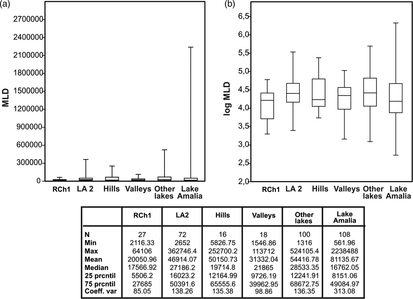
The comparison presented in Figures 6 and 7 shows a slight difference with the data observed in the Amalia locality. Weight and MLD values in this locality show higher means compared to the others, but medians and percentiles are similar. However, it is important to highlight that these graphics do not take into account the refitting at Yar Hayen. Also, the frequency of core fragments in the sites at Amalia locality is significantly higher (Tables 2 and 3). At least part of the cores considered in the boxes of Amalia—equivalents in ranges with those from other localities or landforms—are not complete pieces.
Maximum linear dimension (MLD) of cores and nodules in different localities and settings. MLD values were plotted directly (a), and then a logarithmic transformation was applied (b) to increase homogeneity in the distribution of the data.

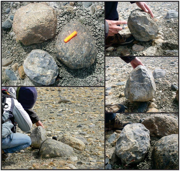
Numerous gravel outcrops were locally recorded, with a notable difference in grain size from the cobbles and gravels exploited as raw material in the Amalia locality. Neither the available cobbles nor the ones definitely used in other localities (Figures 7 and 8) coincide with some nodule types selected in Lake Amalia (see outliers for this locality in Figures 6a and 7a and the example in Figure 8). Without taking into account the refitting masses already mentioned, at Lake Amalia the maximum values, as well as the coefficient of variation, are higher, showing a different use of raw material and the probability of a wider range of sizes and weights available. In the case of the Yar Hayen site, refitting indicates that cobbles up to 9 kg were knapped using a hammerstone and an anvil that weighed 4 kg each. This data may be interpreted in two different ways: a) people were working in situ, having moved to the lake shoreline; or b) they shared a deep knowledge of the availability of a different resource that was restricted to Lake Amalia and uncommon in other areas.
Cobbles and pebbles at the bottom of Lake Amalia. Photos by Jimena Oría.

Following Rockman (Reference Rockman, Rockman and Steele2003), environmental knowledge considers three types of information: locational, limitational, and social. These sets of information are not exclusive, but rather mutually reinforcing. The Amalia locality can be “thought about” in these terms and their connections: “Locational knowledge includes information relating to the spatial and physical characteristics of particular resources… It also includes the ability to relocate such resources after their discovery” (Rockman Reference Rockman, Rockman and Steele2003:4). In this sense, the recurrent visits to the Lake Amalia would not only have economic implications but also social meaning. The former would include those resources that acted as “pull” factors (sensu Rockman Reference Rockman, Rockman and Steele2003), whereas the latter is derived from the need to share some degree of social interaction and information.
Leaving aside the peculiarity of the Yar Hayen workshop, the contexts from the different sites and concentrations in the Amalia locality suggest recurrent use of this space. Borrero (Reference Borrero1985) proposed a pattern to describe the spatial occupation of the northern Tierra del Fuego, which is characterized by high residential mobility with logistical components, particularly in areas lacking certain resources such as raw materials in several sectors of the San Sebastián bay (Borrazzo Reference Borrazzo, Oría and Tivoli2014; Borrazzo et al. Reference Borrazzo, Martin, Barberena, Borrero, Borrero and Franco2008). This model is visible in the archaeological record from the marine coast and surrounding area of the depression San Sebastián-Inútil bays. The archaeological record of this area for the last two millennia shows not only differences at the technological level but also in raw materials used (Borrazzo et al. Reference Borrazzo, Martin, Barberena and Borrero2007, Reference Borrazzo, Martin, Barberena, Borrero, Borrero and Franco2008). Sites farther from the marine coast present lower artifact densities. Additionally, they yield a higher frequency of tools and raw materials of good knapping quality. Borrazzo and others (Reference Borrazzo, Martin, Barberena, Borrero, Borrero and Franco2008) proposed a curated technology for these areas, as opposed to the more expeditious ones present in coastal localities such as Los Chorrillos. Considering that the depression is large enough for the movements of a hunter-gatherer band, the aforementioned differences, among other lines of evidence, support the idea of certain logistical behaviors to exploit the resources available at each space. The model of high mobility is still appropriate, but the significant record heterogeneity found at the depression San Sebastián-Inútil bays suggests a more complex use of the space.
High mobility generates a record characterized by small sites, such as the ones widely observed in the Fuegian steppe. For the northern coast of Tierra del Fuego, the archaeological record shows “both economic and use of space strategies that include frequent visits of a short or medium duration, which may be more frequent in some places than in others” (Horwitz Reference Horwitz, Borrero and Barberena2004:49, translation by author). In San Sebastián bay, the record at the Los Chorrillos locality is interpreted as the result of repeated occupations (Horwitz Reference Horwitz1995), due to the quantity of stratigraphic loci in the dunes and surface artifact density. Although the evidence points towards a recurrent occupation, specific redundancy is low. This means that “the mobility cycles included periodic occupations, but not necessarily of the same locus” (Horwitz Reference Horwitz, Borrero and Barberena2004:45; translation by author).
Southwards, in the area between the Chico and Grande rivers where Lake Amalia and the other localities included in this study are located, the archaeological record adjusts to the high mobility model. In contrast, moving inland, the archaeological record does not fit the logistic elements in the model. At the Amalia locality, samples with high frequencies of tools are recorded. They were knapped from the best quality raw material found at a regional scale, including green obsidian and silicified tuff from the Miraflores locality (see Borrazzo et al. Reference Borrazzo Karen, Borrero, D'Orazio, Etchichury, Massone and Angelis2015 for a discussion about this source of raw material). At the same time, other contexts, such as the Yar Hayen site, exemplify in situ primary exploitation of raw material. Thus, this heterogeneity of the record may be manifested even at the same locality.
Broadly speaking, the inland area shows a scenario similar to the one described by other researchers along the northern coastal sector: the record points to a general use of the space, with ephemeral settlements and very low specific reoccupation. Lake Amalia is probably the only case in which a recurrent visit pattern can be verified at the locality level (Oría Reference Oría2012, Reference Oría, Oría and Tivoli2014; Oría, Salemme et al. Reference Oría, Salemme, Coronato and Vázquez2016; Oría, Salemme, and Fernández Reference Oría, Salemme and Fernández2014; Vázquez et al. Reference Vázquez, Oría and Salemme2016).
According to the record available, hunter-gatherers used this shallow lake intensively throughout the Holocene. In several lakes nearby, isolated findings were also recovered, but their frequency is considerably lower than at Lake Amalia (Oría Reference Oría and Mena2016). The diversity of the record indicates a rather varied and repeated use of the lake area, as exemplified by two relevant sites: Yar Hayen (Oría and Pal Reference Oría and Pal2011) described here, and Yowen Ko, a place that presents a high density of guanaco bones with clear anthropic marks (i.e., cutmarks, thermal alteration), together with some charcoal pieces (Vázquez et al. Reference Vázquez, Oría and Salemme2016). The high number of tools (quite unusual for this area, even in surface contexts) at the Amalia 4 and Amalia 5 loci suggests the reoccupation of the sites or, alternatively, recurrent visits to the area. The evidence for reactivation after fracture in some of the artifacts from Amalia 5 further suggests this interpretation (Oría, Salemme, and Fernández Reference Oría, Salemme and Fernández2014).
Conclusions
Cobbles larger than ones observed in local outcrops of glaciofluvial gravels have been located at Lake Amalia. This difference in raw material supply (as regards to availability and variety) may have been one of the reasons for the recurrent visits, in contrast to what happened in other localities related to shallow lakes in the same area.
Small- or medium-sized gravels are common everywhere in the local landscape, facilitating in situ testing or, alternatively, transport of cobbles to the sites. On the other hand, larger cobbles or boulders, like the ones recorded at the Yar Hayen site or at the bottom of Lake Amalia, had to be worked in situ because of the difficulty implied in their movement. If people made the decision to take advantage of those big boulders, which obviously happened, they must necessarily have moved towards them. Bigger blanks are easier to obtain from these large boulders. Large flakes and blanks of known raw materials were then transported to the sites, avoiding the transport of nodules that end up being discarded after being tested. While cobbles are dispersed throughout the area, the large and good knapping-quality boulders effectively used as raw material do not have homogeneous distribution. Thus, those special places became relevant points in the landscape and, therefore, were repeatedly visited.
Concerning those localities nearer marine coastal environments, the sites Las Vueltas 1, La Arcillosa 2, and Río Chico 1 are examples of revisited places, where human groups were likely to exploit resources present in the landscape, hunt guanaco using natural traps, and collect sea resources. The lithic record in these coastal environments suggests the use of cobbles of small dimensions. Far from the coast, both landscape and ecosystems are different, and so is the availability of supplies. Thus, hunter-gatherers´ movements inland should be related to the availability of resources. In this scenario, during the Holocene, several shallow lakes were visited by groups of terrestrial hunter-gatherers with high mobility strategies. The result is an archaeological record dominated by numerous small sites.
Raw material frequency, size, and spatial distribution would have conditioned the way human populations used the Fuegian steppe. In this sense, the size and weight of the boulders recorded in the Amalia locality could have been a “pull” factor for hunter-gatherers. The record from Lake Amalia fits this high-mobility model and shows a diverse and recurrent use of space. None of the other lakes yielded a similar record. Future studies at Amalia locality will allow a more precise evaluation of its nature as “persistent place” and shed light on occupational redundancy.
Acknowledgements
Grants #0422/10 from CONICET to M.S. and #2013-1997 from ANPCyT to J.O. funded this research. We thank Andrea Coronato and Jorge Rabassa (CADIC) for answering several questions about geomorphology. We are grateful for Ivon and Benjamin Roberts’ hospitality at Estancia Los Flamencos, and Matías Bitsch, who welcomed us at Estancia San Julio. We want to thank all the people who helped with the fieldwork. Fernando Santiago and Martín Vazquez offered valuable opinions that significantly improved previous versions of this manuscript; Jorge Rabassa, Micaela Oría, and Josephine Caminos helped us with the English text, and María Paz Martinoli guided us with the preparation of box plot charts.
Data Availability Statement
Materials included in this paper, as well as the digital data, are held at Centro Austral de Investigaciones Científicas (CADIC) institutional repository.
Supplemental Material
For supplementary material accompanying this article, visit https://doi.org/10.1017/laq.2018.67.
Supplemental Table 1. Types of cores described at sites Amalia 4 and 5.