1. INTRODUCTION – GNSS
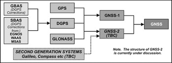
Global Satellite Navigation Systems (GNSS) is the generic term for satellite navigation systems that provide autonomous geo-positioning with global coverage (Figure 1). GNSS-1 is the name given to existing systems (i.e. Global Positioning System [GPS] and GLObal'nayaNAvigatsiomayaSputnikovaSistema [GLONASS]). When GPS is used with corrections from Ground Based Augmentation Systems (GBAS) or Space Based Augmentation Systems (SBAS), it is known as Differential GPS (DGPS). GNSS-2 will include additional second-generation systems (e.g. Galileo, Compass [CNSS], Quasi-Zenith Satellite System [QZSS] and the Indian Regional Navigational Satellite System [IRNSS] etc.).
GNSS Relationships and Terminology.

1.1. Rapid Growth in Civilian Use
Only twenty years ago, civilian use of GNSS was mainly limited to merchant ships’ crews and surveyors; today there are millions of receivers being used in all forms of transport and commerce as well as a wide variety of recreation activities. The major breakthrough came with the introduction of Navstar, more commonly known as GPS; development started in 1973 and the system was declared operational at the end of 1993. ‘Cold War’ rivalry between the Soviet Union and the United States of America (USA) led to the ‘Space Race’ and the almost parallel development of the Soviet system GLONASS. After initial success, GLONASS fell behind in the 1980s and 1990s when too few satellites were launched to sustain a working constellation.
1.2. Augmentation Systems
Increasing civilian use of GPS resulted in the introduction of Selective Availability (SA), which was designed to deny the full accuracy of the system to civilian users and possible adversaries. Unfortunately for the US military authorities, this was easily defeated by means of DGPS, and early commercial services were quickly followed by government funded GBAS (e.g. the US Coast Guard DGPS Network) and by SBAS (e.g. the US Wide Area Augmentation Service [WAAS], the European Geostationary Navigation Overlay Service [EGNOS] and the Japanese Multi-functional Satellite Augmentation System [MSAS]). SBAS all involve the use of Geo-Stationary Earth Orbit (GEO) satellites which are placed 36,000 km above the Equator and rotate in synchronism with Earth rotation.
1.3. More Recent Developments
The ease of use and inherent accuracy of GPS made it very popular with millions of yachtsmen, private pilots and hikers as well as commercial operators in all domains. GPS had rapidly become a vital utility essential to transport infrastructure. This worried politicians and industrial leaders in Europe who were concerned about the increasing reliance on a system controlled and operated by the military authorities of one nation state. In March 2002, the European Union (EU) nations agreed to develop Galileo, a GNSS similar in concept to GPS, but designed primarily for civilian users and including a guaranteed service to meet Safety of Life (SoL) requirements. More recently, the emerging nations in Asia have also commenced development of their own GNSS. But how did it begin?
2. TRANSIT – THE FIRST GNSS
On 4 October 1957, the launch of Sputnik 1 was the start of the Space Age. Listening to the signals from the spacecraft, scientists at John Hopkins University (Applied Physics Laboratory) noticed a large Doppler shift on the signals and were able to use this to determine the satellite orbit from just one ground tracking station. Lateral thinking led them to a concept of reversing the process, that is, to determine an accurate position on the Earth from Doppler signals received from a satellite in a known orbit. The project was given impetus because of the need to position submarines very accurately for the launch of Polaris missiles. In December 1958, the US Department of Defense (DoD) funded the project, and development began in 1959 under the title ‘TRANSIT’. There were three requirements: development and production of a suitable spacecraft, modelling of the Earth's gravity for accurate determination of the spacecraft orbit and development of user equipment. TRANSIT satellites were in Low Earth Orbit (LEO) on a circular polar orbit at an altitude of about 1,000 kilometres and transmitted on two frequencies, 149·99 and 399·97 MHz. TRANSIT was declared operational in January 1964 and was released for civilian use in July 1967. A similar concept was used by the Soviet Union for ‘PARUS’ (a military system with the first prototype satellite launched in 1967) and ‘TSIKADA’ (first launch as Cosmos 883 in 1976). The TRANSIT project demonstrated that spacecraft could be very reliable; some operated for more than 15 years. The project also enabled major advances in the development of algorithms for satellite orbit prediction. TRANSIT ceased operations on 31 December 1996 and all transmissions were shut down.
3. GLOBAL POSITIONING SYSTEM (GPS)
In 1972, another US Navy satellite programme called ‘TIMATION’ was orbiting spacecraft containing precise clocks for time transfer. Just as John Harrison solved the Longitude problem of the 18th Century with his chronometer H4, so meeting the positioning needs of modern times would be made possible by very accurate atomic timepieces. However TIMATION, like TRANSIT, provided only two-dimensional fixes. Meanwhile the US Air Force (USAF) was studying a 3-dimensional navigation system under ‘Project 621B’ and was demonstrating the possibility of using pseudo-random noise for ranging. On 17 April 1973, the US Deputy Secretary of Defense issued a Memorandum amalgamating the two projects, and the ‘Navstar Global Positioning System (GPS) Joint Project Office (JPO)’ was formed. Colonel Brad Parkinson was the first head of the JPO and stayed in post for six years; he continues his involvement with GPS as co-chairman of the US Positioning, Navigation and Timing Advisory Group.
3.1. The Space Segment
All GNSS have three segments: the Space, Ground and User Segments. In June 1974, Rockwell International was awarded a contract for a navigation payload to launch on a US Naval Research Laboratory satellite (NTS-2) and for three GPS prototype satellites to develop the Space Segment; the contract was later extended to eleven satellites. These became known as Block I satellites and were in slightly different orbital planes to the later Block II production satellites (at 63° as against 55° inclination). Their design life was specified as three years, but several operated for more than ten, and that very long operational life has, in the end, become a problem for GPS modernisation because funding for launches is related to the need to replace failed satellites. In June 1977, the first GPS signal from space was transmitted by NTS-2; unfortunately the satellite failed after only eight months. In February 1978, the first GPS Block I satellite (sometimes referred to as NDS) was launched. By December 1978, four Block I satellites were in orbit for testing 3-dimensional navigation; however, this was only available for limited periods at any particular location. The RAF GD Aero-Systems Course made use of these satellites on the Aries Polar flight in September 1980 when, with careful scheduling using Bodo and Thule airfields, a GPS fitted to a Britannia aircraft was in use over the North Pole.
3.2. Ground and User Segments
In October 1974, General Dynamics was awarded a contract to develop the Ground and User Segments. The Control System of the Ground Segment for the validation phase with Block I satellites was built at Vandenberg Air Force Base (AFB) on the California coast. In August 1986, responsibility for managing the GPS Space Segment was handed over to the USAF using the Operational Control System installed at Falcon AFB, since renamed Schriever AFB, in Colorado. General Dynamics sub-contracted development of the first User Segment receivers to Magnavox. Initial testing of these receivers began in March 1977 at the Yuma Proving Ground, Arizona, using solar-powered ground transmitters to simulate satellites (the first pseudolites); signals from over-flying satellites were gradually introduced to these trials as they became available. Because only three satellites are required for 2-D navigation, receivers for naval use were under test off the California coast by October 1978. By the late 80s, military user equipments started to appear in reasonable numbers, but civilian handheld receivers were already in mass production.
3.3. Civilian Use
In 1983, a Korean Airlines 747 strayed badly off route and was shot down by a Soviet fighter which mistook it for a US aircraft thought to be spying in the area. After this incident, President Reagan announced that GPS would be made available for civilian use. But, the US military insisted on the system accuracy being deliberately degraded by Selective Availability (SA). Also in 1983, the Radio Technical Commission for Marine Services (RTCM), Special Committee 104 defined the data format for a marine beacon DGPS capability based on the US Coast Guard system, which effectively defeated SA. Marine DGPS was later adopted by the International Association of Lighthouse Authorities (IALA) for use by merchant shipping and yachtsmen. Having failed to find a sensible charging regime, the DoD announced that the Standard Positioning Service (SPS) of GPS would be broadcast in the clear on the L1 frequency (1575·42 MHz), without encryption. The Precise Positioning Service (PPS) would be broadcast on the L2 frequency (1227·60 MHz) and would be encrypted. In 1988, the International Civil Aviation Organisation (ICAO) announced that the Future Air Navigation System (FANS) would be based on satellite navigation systems. Also in 1988, mainly as a result of the introduction of GPS, the US DoD and the Department of Transport released their first Federal Radionavigation Plan (FRP) setting out US Government Policy on radio navigation aids.
3.4. Production Satellites
February 1989 saw the launch of the first Block II production satellite; after in-depth testing, it was declared operational on 10 August 1989. On 21 June 1989, a contract for Block IIR satellites was awarded to General Electric (later taken over by Martin Marietta); these satellites were planned to have enhanced autonomy, including the capability to achieve a degraded range error for periods up to 180 days without updates from the Ground Segment. This was to be achieved by cross-link ranging with other Block IIR satellites in the constellation, so enabling estimation of the parameters required for the Navigation Message should the Operational Control System be out of action through hostile acts or for other reasons. Unfortunately, the cross-linking was affected by interference from unrelated ground signals that largely negated the original aim.
3.5. Military Use
Throughout the 1980s, satellite navigation systems were not readily accepted by NATO military commanders; they still wanted military systems to have an autonomous navigation capability and not have to rely on external systems. But the impetus for widespread military use of GPS came from Operation Desert Storm during the First Gulf War in 1990, when GPS became a vital tool for navigation and rendezvous. Hundreds of individual soldiers bought single-channel civilian receivers by mail-order because military versions were not available in sufficient numbers. Selective Availability (SA) was turned off throughout the conflict.
3.6. Operational Capability
On 8 December 1993, GPS reached Initial Operational Capability (IOC) with 24 Block I and II satellites in six orbital planes, and the SPS was declared available for civil use (still with SA on). Soon afterwards, the European Council issued a resolution on Europe's contribution to GNSS; this specified that the European Global Navigation Overlay Service (EGNOS) would provide augmentation for GPS and GLONASS, and stated the need for civilian control of future GNSS. GPS and GLONASS were developed for military purposes to design standards acceptable for those requirements; to be acceptable for civilian use, and particularly for Safety of Life (SoL) operations, they needed augmentation to provide better accuracy and much faster time-to-alarm integrity. These augmentations can be based in space using geo-stationary satellites or use ground beacons or other transmitters and are an integral part of what most people now define as GNSS. GPS was finally declared Fully Operationally Capable (FOC) on 17 July 1995 with 24 Block II production satellites in 20,200 kilometre Medium Earth Orbits (MEO). Earlier in May 1995, the 8th Edition of the US FRP 1994 (issued very late) introduced the concept of GPS for ‘sole-means’ positioning, and the proposal to phase-out virtually all other radio navigation aids; this caused much consternation both in the USA and around the world.
3.7. US Presidential Directives and Modernisation
In 1996, an important US Presidential Decision Directive was issued which stated “The Standard Positioning Service (SPS) would be free and that Selective Availability (SA) would be discontinued within a decade with a review annually from the year 2000”. It also initiated the ‘NAVWAR’ program to separate civilian and military signals and provided for the joint management of GPS with representatives from the Departments of Defense, Transportation, State and Commerce. But not everything in the GPS programme worked well; the launch of the first Block IIR on 17 January 1997 was a spectacular failure but they successfully launched the second one in July. Also in July 1997, because of delays in some projects such as the Wide Area Augmentation System (WAAS), and complaints from many national and international users, the US FRP 1996 (again issued late) extended the phase-out dates of a number of radio navigation aids. In early 1998, Vice-President Gore announced the decision to introduce a second civil signal at the L2 frequency (1227·6 MHz), and a few months later a further announcement said a third civil signal on a frequency to be known as L5 (1176·45 MHz) would be developed; this was the beginning of the GPS modernisation programme for civilian users. The original modernization plan left the original L1 frequency with only the outdated ‘Coarse Acquisition’ (C/A) signal for civil applications; however, the more recent addition of the planned L1C signal means that all three GPS frequencies will eventually provide modernized civil signals. The 52nd GPS satellite and the 41st carried on a Delta 2 rocket was launched on 6 November 2004; it was the 13th and last in the Block 2R series.
3.8. New US Policy
On 8 December 2004, the US President authorised a new national policy giving guidance on space-based positioning, navigation and timing programmes, augmentations and activities. This superseded the Presidential Decision Directive on GPS of 1996. The new policy provided guidance for:
a. Development, operation and modernisation of GPS and US-developed augmentations.
b. Development, operation and modernisation of capabilities to protect US and allied access to GPS for national, homeland and economic security, and denial to adversaries of access to any space-based positioning, navigation, and timing services.
c. Cooperation with foreign space-based positioning, navigation and timing services, including augmentations.
3.9. Modernisation Progress
On 26 September 2005, a Boeing Delta II rocket carried the first Lockheed Martin GPS IIR-M satellite into orbit from Cape Canaveral. GPS IIR-M (modernised) satellites have increased power and provide the new military signals, but of importance for general use is a second civilian signal. Not only does this make GPS more robust in the face of interference, but it will also improve accuracy by allowing receivers to compensate for atmospheric effects in real-time. These new capabilities will not be available until the majority of satellites in orbit are modernised versions; however, the rate at which they are introduced depends on the longevity of old satellites. The eight GPS Block IIR(M)s were launched between 25 September 2006 and 17 August 2009; they joined the eleven Block IIA and twelve IIR satellites still in-orbit within the 31-spacecraft constellation. The US faced a deadline for having the L5 signal transmitting from a satellite in orbit by 26 August 2009, in order to meet an International Telecommunications Union (ITU) requirement to secure the frequency allocation. The launch of IIR-20(M) met that need, but the satellite suffered other signal anomaly problems and has since been shut down. GPS launches over the past 20 years relied on Delta 2 rockets for delivery into orbit, but the latest Block IIF satellites use the larger and more capable Delta 4 and Atlas 5 rockets that can propel them directly into orbit. The first launch of twelve Block IIF GPS satellites, also with the second civil frequency, flexible power output and M-codes, but additionally with the third (L5) civil frequency and a 12-year design life, was scheduled for 2006 then 2007, 2008, 2009 and was eventually launched on 28 May 2010. GPS IIF-1 was the 61st GPS satellite launched; GPS IIF-2 was launched on 16 July 2011.
3.10. Ground Segment Modernisation
While attention is inevitably given to modernisation of the Space Segment, major work has also been undertaken to improve and update the Ground Segment and its Operational Control System (OCS). The primary Master Control Station at Schriever AFB has been modernised with a new mainframe computer and distributed architecture, and a fully mission capable Alternate Master Control Station (AMCS) has been established at the Vandenberg tracking station. The monitor stations have been upgraded with new antennas, digital receivers and computers and a major initiative to improve system accuracy has been completed. Clearly, the OCS needs to remain responsive to the changing needs of the Space Segment as new satellites become operational; to that end, a contract was awarded to Raytheon in February 2010 for the design of the Next Generation Control Systems (OCX).
3.11. GPS Block III
On 21 December 2006, the USAF awarded Lockheed Martin a $50 million contract to undertake a System Design Review (SDR) for the ‘next generation GPS Segment Programme’ to be known as GPS Block III. Lockheed Martin Space Systems is also under contract to produce the first two of eight planned GPS IIIA satellites with full military codes, new L1C signal and enhanced anti-jam capability. The original plan was for the first launch to occur in 2013 but this slipped to 2014 because the US Congress reduced the funding for GPS III in 2008. The reasons given were that the DoD started new space programmes too soon when earlier ones were hardly underway. The example cited was “… the contract decision on GPS IIIA [was made] before the first Block IIF had been launched or had even completed ground testing!” GPS IIIA should deliver signals three times more accurately than current GPS spacecraft and provide three-times more power for military users. The Block III programme is expected to evolve through IIIB and IIIC to achieve the full aims of GPS modernisation and NAVWAR including spot beams and integrity monitoring.
4. GLONASS
The 1980s and 1990s was still the era of the ‘Cold War’ and the ‘Space Race’ between the USA and the USSR. The Soviet Union launched their first GLONASS satellites on 12 October 1982; between 1982 and 1985, they launched 10 more. GLONASS has a different constellation design to GPS using only three, slightly lower, orbital planes at 64·8° inclination and, at the moment, uses Frequency Division Multiple Access (FDMA) rather than the Code Division Multiple Access (CDMA) system used by GPS; however, this is planned for change in the Russian Federation's modernisation plans. During the Cold War, much effort was devoted to propaganda and the Kremlin needed to appear to be ahead of the Pentagon in the Space Race; thus GLONASS was declared to have an Initial Operational Capability (IOC) in the Spring of 1985; this clearly wasn't true as development of the User Segment was a long way behind.
4.1. Changes to GLONASS
In 1993, President Yeltsin declared GLONASS to be fully operational, but again, it clearly wasn't. Also in 1993, the GLONASS Geodetic Datum was changed from SGS 85 to PZ90. In 1994, the International Telecommunications Union (ITU) identified problems associated with interference from certain GLONASS frequencies in the 1·6 GHz band on radio astronomy systems. The Soviet Union had never applied to the ITU for frequency allocations because GLONASS was a military system. As a result, changes had to be made and further changes were required in 2003 to reduce the number of frequencies used. On 7 March 1995, Prime Minister Chernomyrdin issued a Decree stating the intention to achieve a full constellation of 24 GLONASS satellites, which was completed on 18 January 1996 with 24 working satellites in orbit plus 1 spare. On 27 November 1996 and 30 June 1997, GLONASS was taken out of service to re-align the system's timing much closer to UTC.
4.2. Satellite Launches and Design Life
Since 1982, over 100 GLONASS satellites have been launched. On average, the early GLONASS satellites exceeded their 3-year design life but, while a launch of three GLONASS satellites occurred in most years, this was insufficient and only just kept the system alive with an average of less than ten operating satellites between 1998 and 2006. However, funding has improved and the constellation is being re-built; one hope is that the new GLONASS M and K satellites will at least achieve their designed life of 7 and 10 years respectively and so help the Russian Federation rebuild and maintain the constellation at 24 satellites. Following a visit to New Delhi by President Putin, the Indian and Russian governments reached an agreement on GLONASS. Under the agreement, India may provide launch vehicles to speed up the recovery of GLONASS minimal operational status in return for access to the system's military signals for its armed forces. The agreement also provided for industrial cooperation on satellite design, end-user receivers and software packages. Some analysts believe the agreement went ahead because Indian officials were frustrated by continuing delays in the discussions between the EC and India on Galileo.
4.3. GLONASS Modernisation
Cosmos-2404/GLONASS-701, the first GLONASS M satellite was launched on 10 December 2003 and after a very long period of tests was accepted for service on 12 December 2004; however, it was de-commissioned in June 2009, so did not achieve its design life of 5 years. Another launch of three GLONASS satellites occurred on 26 December 2004. One of these was a GLONASS-M and the other two the older model satellites. This brought the total number of GLONASS satellites in orbit to 14. This second GLONASS-M was finally ‘set healthy’ on 7 October 2005. A further launch of three GLONASS satellites took place on 25 December 2005, including two GLONASS-M, and were ‘set healthy’ on 31 August 2006. According to a source from the Committee for Industries, Construction and High Technologies in the Lower House of the Russian Parliament, Russian Federal authorities said they would double the financing of work on GLONASS in 2007. The report concluded that: “The Global Navigation System Federal programme aims to help preserve Russia's independence from other major providers of space services in terms of satellite navigation, as well as to ensure safe and efficient functioning of its transportation systems”. On each of nine dates, 25 December 2006, 26 October 2007, 25 December 2007, 25 September 2008, 25 December 2008, 14 December 2009, 1 March 2010, 2 September 2010 and 5 December 2010, Proton rockets lifted off from the Baikonur space centre in Kazakhstan, each carrying three GLONASS-M satellites. These launches were the final part of the Russian Federal Space Agency (Roscosmos) plan to have a full constellation of 24 satellites by the end of 2010, but the latest launch failed and the three satellites crashed into the Pacific Ocean; the head of the Roscosmos was dismissed as a consequence. The first launch of a GLONASS-K took place on 26 February 2011; this was the first GLONASS satellite to transmit a CDMA signal. Roscosmos announced that four GLONASS-M satellites would be launched during 2011; the first was launched on 2 October from Plesetsk Cosmodrome by a Soyuz-2-1B and three more are planned for launch on 25 October from Baikonur Cosmodrome using a Proton-M rocket. If these launches are successful, Full Operational Capability (FOC) for GLONASS should have been declared by the time this paper is published.
5. GALILEO
As stated earlier, the European Council issued a resolution on Europe's contribution to GNSS in 1993, which specified EGNOS to augment GPS and GLONASS for civilian use. In the late 1990s, two important documents were issued by the European Commission (EC); they spelled the beginnings of the Galileo project. On 21 January 1998, the EC issued a strategy document ‘COM (1998), Towards a Trans-European Positioning and Navigation Network: including, A European Strategy for Global Navigation Satellite Systems’; it was endorsed by the Council of Ministers on 17 March 1998. On 9 February 1999, they issued a communication ‘COM (1999) 54, Galileo, Involving Europe in a New Generation of Satellite Navigation Services’. In November 1999, the EC released four contracts to industry for Galileo definition. On 8 December 1999, the European Space Agency (ESA) signed a contract called the ‘Galileo Sat Study’ for the definition phase of Galileo. On 1st May 2000, somewhat earlier than expected, GPS SA was removed; in Europe this was cynically perceived as an attempt to undermine the Galileo project. On 6 December 2000, the EU Summit Meeting expressed support for Galileo but at the EU Transport Ministers Meeting two weeks later, the Ministers could not agree on full development; the reasons given were: dissatisfaction with Public/Private finance proposals, and concerns over the proposed management structure. Only limited development was approved until these points had been answered; the Ministers asked for further information to be available at their April 2001 meeting. At that meeting, they were still not satisfied that their concerns had been answered. Near-term actions were: to produce a preliminary definition of services, to consolidate cost and benefit estimates, and to establish an interim management structure.
5.1. Slow Decision Making
In June 2001, the concept of a Galileo Joint Undertaking (GJU) was proposed to bring together the EC, ESA and any other public and private funding bodies. The Joint Undertaking was to be set up for an initial duration of four years and be based in Brussels. Until the new entity could be established, a Galileo Interim Support Structure was put in place. These actions were expected to meet the immediate concerns of the Transport Ministers on the Galileo management structure. On 15 November 2001, the ESA Council committed its share (€550 million) of the funds required for the Galileo development and validation phases; however, a positive decision was still needed from the EU Transport Ministers for release of the equivalent EU funds and agreement to the formation of the GJU. Their meeting in December 2001 was expected to be a crucial milestone for Galileo; however, they did not agree to the launch of the development phase or the establishment of the GJU. The reason they gave was a need for further study of the economic perspectives; decisions were delayed, with some release of funding (€100 million) to keep the project definition moving. They finally reached agreement on 26 March 2002 and released the remaining €450 million for the development/validation phases and sanctioned the creation of the GJU to manage these phases. However, further progress relied on ESA agreement and a new dispute began between Germany and Italy about who should lead the project. Both nations tried to outbid each other, which meant the overall project would be over-funded and therefore couldn't proceed. The dispute continued until an agreement was at last achieved on 26 May 2003. On 10 December 2004, the EU Transport Council confirmed the technical characteristics of the Galileo system, particularly regarding the services to be offered. Jacques Barrot, Commission Vice President for Transport said: “Galileo is without a doubt the most wonderful European technological project. We are now on the home straight: next year will see the launch of the first satellites. Galileo will be as much of a technological revolution as mobile telephony. This venture shows how capable Europe is of making a united effort in pursuit of a common goal.”
5.2. EU/US Agreement
After much discussion and many delays, an EU/US agreement for cooperation on GNSS was finally signed on 26 June 2004; this covered:
a. A process allowing optimization, either jointly or individually, of the baseline signal structures in order to further improve performances.
b. Adoption of a common baseline signal structure for their respective open services and confirmation of a suitable baseline signal structure for the Galileo Public Regulated Service (PRS).
c. Confirmation of interoperable time and geodesy standards to facilitate the joint use of GPS and Galileo.
d. Non-discrimination in trade in satellite navigation goods and services and a commitment to preserve national security capabilities.
e. Agreement not to restrict use of or access to respective open services by end-users.
5.3. Funding Issues
New funding problems emerged with Galileo as additional calls were made and some nations tried to gain an advantage for their national industry by withholding funds. Development was expected to run until 2008 at a cost of €1.5 billion, shared equally between the EC and ESA. The GJU had been negotiating since June with the Eurely-Inavsat consortium for the deployment and operational phases, but these negotiations eventually failed in 2007. After much political wrangling, the Public/Private Partnership funding arrangements were abandoned and the EU/EC accepted that the deployment of Galileo would be funded as a public infrastructure project within the existing transport budget.
5.4. First Launches
Two test satellites have been built and launched for Galileo, one by the Surrey Space Centre and the other by Astrium. Their primary aims were: to secure the use of the Galileo frequencies allocated by the ITU at the World Radio Conference 2000, to demonstrate critical technologies for the navigation payloads of operational satellites and to characterize the radiation environment of the orbits planned for Galileo. GIOVE-A was launched from the Baikonur cosmodrome in Kazakhstan on 28 December 2005 and was successful in meeting the ITU frequency transmission requirements within a few weeks. This allowed the launch of GIOVE-B to be delayed so that better use could be made of it during the IOV phase. This was fortunate as GIOVE-B had suffered a number of failures in ground testing and was not ready for launch anyway. The EC published a deployment date of 2008; the original (very optimistic) concept was for the system to be fully operational by 2008, but now that year was planned for the launch of only the first four operational satellites, but these launches were also delayed. The GIOVE-B satellite was launched by a Soyuz/Fregat rocket on 27 April 2008. The Fregat upper stage performed a series of manoeuvres to reach a circular orbit inclined at 56° to the Equator, before safely delivering the satellite into orbit.
5.5. In-Orbit Validation
The next step in the Galileo programme will be to validate the basic Galileo space and related ground segment using four In-Orbit Validation (IOV) satellites. By the publication date of this paper, the first two IOV satellites, known as Protoflight Model (PFM) and Flight Model 2 (FM2) should have been launched using a modified Soyuz rocket from the EU's spaceport in French Guiana to convey the Galileo satellites into their circular orbits at an altitude of 23,222 km. The Soyuz ST-B is the most powerful version of the famous Soyuz launcher, while the Fregat-MT is an upgraded version of the Fregat upper stage which carries an additional 900 kg of propellants for its double-satellite load. Because French Guiana is so close to the Equator, each launch will benefit from the Earth's spin, increasing the maximum payload to geostationary transfer orbit from 1·7 tonnes to 3·0 tonnes. These four Galileo IOV satellites are fully representative of those that will follow them into orbit, carrying the best atomic clock ever flown for navigation, designed to be accurate to one second in three million years.
5.6. Future Plans
Once the IOV phase is completed, the remaining Galileo satellites will be launched and deployed to reach the Full Operational Capability (FOC). The signing of a framework contract in December 2009, with both OHB System AG and EADS-Astrium GmBH, paved the way for the eventual provision of a maximum of 32 satellites. On 7 January 2010, the EC announced the award of three of the six contracts for the procurement of Galileo's Initial Operational Capability. The contract for the system support services was awarded to Thales Alenia Space of Italy, and a contract for a first order of 14 satellites to OHB System AG of Germany at a value of €566 million. The contract for the launch services was awarded to Ariane Space of France and covers five Soyuz launches each carrying two satellites at a value of €397 million. On 25 October 2010, the contract for the Galileo operations was signed with SpaceOpal GmbH (an Italian-German joint venture) by ESA on behalf of the EC. On 23 June 2011, the EC announced the final two contracts at a combined value of €355 million. One contract signed with Thales Alenia Space (FR), for a value of €281 million, ensures the formatting of navigation information for broadcast by the satellites. The contract signed with Astrium (UK), for a value of €73.5 million concerns the ‘housekeeping’ of the satellites including their maintenance and correct positioning in orbit. The EC is now able to promise better estimates for the provision of the range of Galileo services: the Open Service, the Public Regulated Service (PRS) and the Search and Rescue (SAR) Service are planned to be declared in 2014 using 18 satellites. The Safety-of-Life (SoL) Service and the Commercial Service (CS) will be tested in 2014 and will be provided when Galileo reaches FOC with a constellation of 30 satellites in 2020.
6. CHINA
6.1. Beidou-1
At a Beijing forum to mark the 50th anniversary of China's space industry, the China National Space Administration (CNSA) stated that the Beidou 1 navigation satellite system would be operational by 2010. It had already launched three test and two production satellites – the test satellites in October and December 2000 and May 2003 – these are GEOs based on a communications satellite design; the two production satellites were launched on 3 February 2007. The ground systems include the central control station, ground correction stations, and user terminals (receivers/transmitters). The system is based on transponder technology working at 2491·75 MHz and is claimed to have a capacity of 540,000 responses per hour. This provides 2-D positioning data of about 100 metre accuracy. By using ground correction stations, the accuracy can be improved to 20 metres.
6.2. CNSS – Beidou-2
The Compass Navigation Satellite System (CNSS), or Beidou 2, is China's second-generation satellite navigation system capable of providing continuous, real-time passive 3-D geo-spatial positioning and speed measurement. After launches in 2010, CNSS now has one medium-Earth orbit, three Inclined Geostationary Satellite Orbit (IGSO), and four GEO satellites operating in orbit. Speaking at the second Chinese Satellite Navigation Academic Annual Meeting in Shanghai on May 18, Ran Chengqi, the director of the Chinese Satellite Navigation Administrative Office, said “… the overall testing of the Compass/Beidou satellite navigation system will be finished by 10th October 2011”. According to RanChengqi, a 16-satellite system covering the Asian-Pacific region will be established to provide high-accuracy positioning services for users in China and its neighbours, covering an area of about 120 degrees Longitude in the Northern Hemisphere. In addition to the eight satellites that have already been launched, China will launch another eight CNSS satellites before the end of 2012. The system will initially provide two types of service. A free service will be provided for civilian users with positioning accuracy within 10 metres, velocity accuracy within 0·2 m/s and timing accuracy within 50 nanoseconds; a licensed service will be provided with higher accuracy for authorised and military users only. The long-term goal is to develop a GNSS similar to the GPS and GLONASS by extending the system into a global constellation comprising 5 GEO, 3 IGSO and 27 MEO satellites.
7. JAPAN – QZSS
As well as the introduction of MSAS, Japan is planning a Quasi-Zenith Satellite System (QZSS) using three satellites. The first satellite ‘Michibiki’ was launched on 11 September 2010 and was ‘set usable’ on 24 June 2011. FOC status is expected by 2013. QZSS is targeted at mobile applications, to provide communications-based services (video, audio, and data) and positioning, for which it can only provide limited accuracy on its own and is not currently required in its specifications to work in a stand-alone mode. The highly elliptical orbits allow the satellite to dwell for more than 12 hours a day with an elevation above 70° (meaning they appear almost overhead most of the time) and give rise to the term ‘quasi-zenith’ after which the system is named.
8. INDIA
8.1. GAGAN
India's system is named GPS Aided GEO Augmented Navigation (GAGAN). India's first GAGAN navigation payload on the GSAT-8 communications satellite was launched successfully on 21 May 2011. The satellite was carried by an Ariane-V launch vehicle from the European Union's spaceport in French Guiana. This is the first successful launch for India's satellite-based regional SBAS. GAGAN is designed to function for 12 years.
8.2. INRSS
The Indian Regional Navigational Satellite System (IRNSS) is an autonomous regional satellite navigation system being developed by Indian Space Research Organisation. The plan to build a constellation of seven geo-stationary satellites to meet the nation's needs for a navigational system in cars, trains and aircraft was announced on 4 September 2007; all seven satellites should be built by the end of 2012.
9. GNSS VULNERABILITY
The vulnerability of GNSS can be considered under four headings: unintentional interference, intentional interference, human factors and provider funding. Since the earliest operation of GPS, concerns have been expressed about its vulnerability, partly because the current civil signal is still limited to only one frequency L1, and partly because the signals are extremely weak and easily interfered with or blocked despite the improvement in signal-to-noise ratio achieved by receivers seeking specific codes amongst the background noise.
9.1. Unintentional Interference
Trials and testing to check the vulnerability of systems to local jamming has caused loss of signals to other users despite publication of the intended timing and location of these jamming transmissions. There is also a well recorded case of an active TV antenna on a houseboat in a US harbour which jammed all GPS receivers in the harbour for several hours each evening when the resident returned from work; it took months to detect and pinpoint the cause. Environmental effects in the Earth's ionosphere and from the Sun can also affect GPS reception; the latest sunspot cycle maximum is occurring now and is expected to be more severe than the last one. Increasing demand on the radio spectrum from commercial communications operators has threatened GNSS frequencies (e.g. the recently proposed broadband services bid by LightSquared, which has now been denied until a plan that completely protects existing GPS navigation devices from this potential interference is proven).
9.2. Intentional Interference
Intentional interference can result from jamming; GPS signals are typically specified at around 160 dBW, really only a ‘squeak’ in background noise and a billion times weaker than the signals used by a typical broadcast TV set; the power required at a GPS receiver antenna is in the order of a Picowatt (10−12 watts). Another form of intentional interference is spoofing; two forms exist: ‘meaconing’ which is the delay and re-broadcast of the GPS signal, and ‘counterfeit’ signals. The C/A Code is short and well known, signal generators are widely available and thus both methods are easy to achieve. Finally, there is a prospect of system damage either through attack on the satellites, which would be very difficult to achieve, or attack on the ground control system, which would be much easier; both such attacks could cause long-term GNSS outage.
9.3. Human Factors
The grounding of the vessel ‘Royal Majesty’ to the East of Nantucket on 10th June 1995 was caused by over-reliance on a single navigation system, poor maintenance practice and inadequate system integration. Unfortunately, the ease of using GPS has led to instances of such over-reliance and a general lack of knowledge of the vulnerability of GNSS.
9.4. Service Provider Funding
GPS, GLONASS and Galileo have all suffered from under-funding during operations or development. While GPS has not failed to provide a service since it was declared operational, funding restrictions have affected the JPO's ability to upgrade the system, mainly because the satellites have wildly exceeded their design life (e.g. one Block IIA-11 satellite [SVN 24] reached 20 years in orbit on 4 July). SVN-24 was the second in the series of GPS IIA satellites to be launched – with a design life of 7·5 years; not only are these GPS Block IIA satellites exceeding their design life but they are doubling it and, in the cases of SVN-24 and SVN-23 their orbit life has nearly tripled. Meanwhile, GLONASS suffered severe funding limitations that meant the constellation was virtually unusable over more than a decade from the mid-1990s. Galileo suffered from funding problems even before development began and is still suffering.
9.5. Dependence on GNSS
Operations in many domains have become more and more dependent on GPS. For example, in maritime operations: the Automatic Information System (AIS), the Global Maritime Distress & Safety System (GMDSS) and the Electronic Chart Display & Information System (ECDIS) are all reliant on or driven by GPS positioning. In aviation, the Enhanced Ground Proximity Warning System (EGPWS), Automatic Dependent Surveillance (ADS) and ADS-Broadcast also rely on GPS, and there is major growth in the use of GPS for Landing Systems. On the ground, utilities such as power distribution, banking and cellphone provision rely on GPS for timing synchronisation. And there is increasing use of GPS for emergency services, vehicle management systems, road tolling and congestion charging.
9.6. The Volpe Report
The Volpe Report was a vulnerability assessment of the US transportation infrastructure because of its increasing reliance on GPS. It considered all of the above vulnerabilities including the possible impact of GPS outages on utilities, communications and banking. It was issued the day before the infamous ‘9/11’ attack on the World Trade Centre in New York, which gave the findings added influence on political decision making. Its general findings were that:
• GPS is a tempting target and its use as a sole-means of position and timing is unacceptable.
• Loss of GPS could have a severe impact on safety and risk environmental and economic damage to the USA.
• Augmentations (WAAS etc.) help but don't solve the problem of GPS signal loss, so back-ups are needed.
10. CONCLUSIONS
• GNSS was originally designed as a military ‘force-multiplier’ for accurate navigation and positioning, for rendezvous and for precision weapon aiming. Because of its inherent accuracy and ease of use, it has become a vital utility for transport infrastructure and a wide range of military and civilian applications in what is now recognised as the ‘age of information’, for which accurate position and timing are essential pre-requisites.
• GNSS is vulnerable for a number of reasons including its susceptibility to both unintentional and intentional interference. But the greater risk stems from the dramatic growth of dependence and over-reliance on its use without adequate back-up systems and procedures.
• The history of GNSS is relatively short, particularly that part relating to the massive expansion of civilian applications in the 1990s and into the 21st Century. The ‘Gold Standard’ is clearly GPS, against which all other developing systems must be judged. Apart from Russia's GLONASS and Europe's Galileo, many other systems for regional augmentation or full GNSS capability are in operation or planned by many nations. Development has been, and continues, at a rapid pace.