1. INTRODUCTION
In many services dealing with navigation and route guidance of passengers on public transport systems, current user assistance concentrates only on routing from a start point A to a destination B. In large multi-modal transit interchanges, people often have difficulty in finding their way from one line to another. Enabling a smooth transit is the major aim of this study. To provide such a service the use of Wi-Fi and Radio Frequency Identification (RFID) positioning is investigated and new concepts developed. For Wi-Fi positioning, the use of a differential approach termed DWi-Fi is suggested which is derived from the well-known Differential Global Navigation Satellite System (DGNSS) operational principle. Using this novel approach, it is possible to significantly improve the performance of Wi-Fi lateration. In the case of RFID, an approach referred to as ‘virtual gates’ is employed where RFID systems, are installed, for instance, at traffic interchange station entrances or exits. Thus, RFID serves also as an independent and redundant second localisation technology. The two positioning technologies are integrated in an intelligent Cooperative Positioning (CP) approach where different users can be guided simultaneously. The user who needs help in determining their current position is then assisted by the known location of other users due to CP. The other users are asked to give their consent to be part of this CP service. Additionally, the end-user's acceptance of the localisation technologies and the user needs are major research foci apart from enhancing technological developments.
The paper is organised as follows: First, the background of the study is elaborated followed by a detailed presentation and assessment of the InKoPoMoVer study. Then Wi-Fi and RFID for positioning of passengers are investigated and a novel approach based on DWi-Fi and CP is introduced. Discussion and remarks concerning ethical and sociological aspects as well as privacy issues conclude the paper.
2. STUDY AIMS
Route guidance of passengers is usually only performed at the macro-level, i.e., the user is provided with information services about which public transport means can be used to travel from a start point A to a destination B. The transport authority of Vienna (Wiener Linien), for instance, provides a service at the macro-level, i.e., the ‘qando’ service, which already successfully uses internet-based route planning. For the users, however, no real-time data is provided but several possibilities for route planning are suggested based on timetables.
In this study, an additional routing system at the micro-level is foreseen. This means that a passenger receives assistance and guidance when transferring between different means of transportation in a multi-modal transit interchange where different public and other transportation means are available. An example is the provision of guidance instructions for transferring between different platforms of underground or metro lines or trains. In the following paragraphs the objectives of the study are presented and discussed.
2.1. Problems Associated with the State-of-the-Art
In reality, passengers may have many difficulties in finding or reaching their connecting train, underground or metro line, bus, etc., in very large multi-modal transit interchanges. This is mainly due to the high complexity of many transit interchanges and the lack of real-time transportation guidance information. Hence, navigation and guidance at the micro-level is required in real-time to close the gap and smoothly guide users from their start point A to their destination B in multimodal transportation networks. Furthermore, little knowledge is available from current research about people's indoor mobility patterns as existing behaviour modelling mainly focuses on outdoor patterns. This study aims at addressing these challenges.
2.2. General Objectives
A steady flow of passenger traffic and support to people who are unfamiliar with the transfer situation is a major aim. This can be achieved by the development of a system for positioning, navigation and if necessary diversion of people at multi-modal public traffic interchanges. To overcome the aforementioned limitations in route guidance at the micro-level, existing services need to be developed further with regard to the following three aspects:
-
• Smooth transit: providing real-time information for passengers to smoothly transit at stations where they need to change their transport modes or lines, e.g., real-time information about their connecting trains and underground lines, alternative routes, indoor navigation guidance;
-
• Indoor modelling: modelling passengers' travelling behaviours within the transit stations, e.g., typical routes from one underground line to another, and time-dependent patterns (e.g. during rush hours); results of this part can provide inputs for the traffic management sectors to make decisions, e.g., during an emergency, service maintenance; and
-
• End-user orientation: development of an end-user oriented demonstrator of a guidance system and service for routing of individuals and/or user groups.
2.3. Solution Strategy
A novel positioning and navigation system based on CP is to be developed to achieve the above-mentioned aims. In our concept, not only an individual but the group of all users are positioned absolutely and relatively to each other. Thus an enhancement of a single positioning system to sensor networks takes place which guarantees a resource efficient and qualitatively optimised position and trajectory estimation.
Similar to Differential Global Positioning Systems (DGPS), the method of Differential Wi-Fi (DWi-Fi) and RFID for virtual gates is employed. In addition, sensors available in modern smartphones and tablets such as inertial sensors consisting of accelerometers and gyroscopes as well as magnetometers or digital compasses are included and integrated with Wi-Fi and RFID as well as with dynamic measuring-technical infrastructures. Use of protected, legally sensitive data, such as cellular phone network data or cellular positioning, for instance, is explicitly not foreseen.
The service will be user-oriented and interactive to allow for real-time guidance in transit stations, which also takes into account the available time and crowdedness determined by the user groups. This will support users smoothly transiting at the stations, thus, closing the gap in current multi-modal transport information systems.
Movement patterns of the participants can be derived from trajectory analysis. It is then possible that the service users' group can provide assistance to a person who has lost his or her orientation. The system processes the information about the different flows of traffic taking into account traffic jam announcements, delays, diversions, failures, etc., and then offers the fastest possible connection from A to B. Where appropriate this is guaranteed by tracking a large number of CP service users. Thus the guidance management for large crowds at critical spots, such as bottlenecks in the possible user's trajectories, is achievable, for instance, at the end of soccer matches, security checkpoints at airports, etc. Hence, people guidance at mass events is also considered in this study. The navigation contains not only the calculation of the fastest and safest route to the destination but also includes information about points of interest as well as information about the cheapest route for price-sensitive users. The purchase of tickets for public transportation means is then combined with the route choice on the mobile device.
Social scientists have been consulted to openly address ethical issues connected with privacy and data security. Heterogeneous user groups are involved to investigate the acceptance of the navigation and guidance service. A holistic innovation understanding is followed and is oriented towards the needs of the end-users. The interests, needs and behaviour patterns of the population offer starting points for innovation and development. The urban lifestyles which come with a greater flexibility, mobility and need for efficiency can be supported by means of intelligent route guidance. Besides it is also essential to address potential barriers to utilisation, above all those concerning ethical and data protected juridical acceptance. This work is not only about orientation towards the end-user, but also about the differentiation of different target groups and their active involvement in the scenario development. For this reason, an extensive need and acceptance analysis will be carried out which aims at:
-
• Identification of possible end-user groups;
-
• Collection of their actual need as well as estimation of their acceptance in view of ethical implications of such technologies; and
-
• Elaboration of the need and use situations in so-called ‘Living Labs’ where a city is considered as ‘social lab’ (Wanka, Reference Wanka2014).
2.4. Innovation
Assisting a user who does not know his way between different means of transportation or has lost his orientation can be achieved if other service users who know their way and the current location provide help to users in need of guidance on the basis of the principle that ‘everybody helps everybody’. For positioning of a certain user, the DWi-Fi approach is new and is not available in this form yet. It is applicable in environments where Wi-Fi is available. Also, the integration of DWi-Fi and RFID is an absolute novelty. Furthermore, the intelligent CP method is developed.
The approach focuses on the derivation of movement patterns of individuals or groups of persons from the ascertained trajectories and their analysis which forms the basis for the determination of highly populated areas in the traffic interchanges in which people flows concentrate. Thereby, the identification of highly populated areas or bottlenecks in the station layout is made possible through the common indoor positioning and trajectory estimation of the whole user group. Typical uses of the service are the improvement of the management of passenger flows which originate, for instance, at rush hours and large mass events. Then the security of the traffic flow is increased in these situations and a contribution to the traffic management is made, e.g., during an emergency or service interruption.
The project is designed to promote research in the area of multi-modal transport information services (e.g., Advanced Traveller Information System, ATIS) and indoor positioning. In comparison to the present state of the research, the following innovations can be emphasised from a cartographic point of view:
-
• A better understanding of the movement behaviour of people at traffic interchanges;
-
• Development of a method for determining the time required for changing between lines taking account of crowded spots in the public traffic interchanges;
-
• Specifications for landmarks for interchange situations and their role in navigation;
-
• Development of a method for effective map and Augmented Reality (AR)-based route communication in interchange situations.
The acceptance of the new service is examined in detail. In addition, an added value for all interest groups is achieved by integration of all stakeholders dealing with traffic management, such as public transport and train operators, taxis, car sharing, city bikes, etc.
3. APPLICATION OF WI-FI AND RFID FOR POSITIONING
It has been identified that Wi-Fi and RFID are suitable localisation techniques for the use case scenario under consideration. Hence, Wi-Fi positioning using lateration is briefly reviewed in this section followed by a description of the novel DWi-Fi approach. Additionally, RFID is employed as a secondary redundant localisation technology. Both technologies are integrated into an intelligent CP solution.
3.1. Wi-Fi Lateration and DWi-Fi Operational Principles
Lateration is one possible technology in Wi-Fi positioning, differing from cell-based positioning or location fingerprinting. The positioning method is based on the distance, or distance-related observables. The location of a mobile device can then be found on intersection of three (or more) spherical surfaces. The centres of the spheres are the known Access Point (AP) positions and their radii are the distance between the corresponding AP and the mobile device. The Received Signal Strength (RSS) is the major observed component. A propagation model estimates the relationship between the RSS and distance. Theoretically, the power of the RF signals decreases when it propagates into space and therefore the RSS decreases with the transmitted energy (Feuerstein et al., Reference Feuerstein, Blackard, Rappaport, Seidel and Xia1994; Rappaport, Reference Rappaport1996). Hence, the nature of the RSS varies with the changes of distance between transmitters and receivers.
A number of models, termed path loss models, have been developed to establish the relationship between the RSS and the propagation distances. Thereby path loss is defined as the dB reduction in power from the transmitter to the receiver location, where the received power is spatially averaged around the location. Specifically, it is averaged over an area whose radius is several wavelengths, with the wavelength being that at the centre frequency of the transmission. When the assumptions of the model can be accepted, the distances between the transmitters and the receiver can be calculated easily according to the RSS by inverting the model (Ghassemzadeh et al., Reference Ghassemzadeh, Greenstein, Kavcic, Sveinsson and Tarokh2003).
One of the simplest models, which describes the decreasing trend without the effects of reflections and obstructions, is presented as the log-distance path loss model. The measured RSS readings and distances are then used to fit the signal propagation model and the signal-to-distance relationship. An alternative method is to use regression models based on the previous measured RSS to establish the relationship between distance and RSS. This method considers the effects of the environment on RSS using statistical methods. This approach apparently increases the accuracy of modelling the RSS trend in the specific areas where the RSS data were collected for the regression. Yang and Chen (Reference Yang and Chen2009) found in their experiments that regression-based methods can significantly improve the localisation accuracy of original lateration methods. Apart from linear regression models, different degrees of polynomial fitting may also be used.
For different environments either log-distance or linear path loss models are more suitable. Usually, in outdoor environments they are close to the log-distance pattern and in the indoor environment along a corridor to a linear pattern. This is mainly due to the differences in the environments. In the indoor environment, the walls, ceilings and floors can form a structure called a waveguide. This structure forces the Radio Frequency (RF) signals to propagate in particular directions (e.g. the two directions along an indoor corridor) and, consequently, changes the path loss patterns of the signal propagation and increases the errors in distance estimation using RSS.
The limitation is that most of the theoretical models are subject to free space propagation or signal propagation in a simple environment. Line-Of-Sight (LOS) and Non-Line-Of-Sight (NLOS) scenarios represent different signal propagation environments indoors. The spatial and temporal fluctuation of RSS reduces the accuracy of the location estimation considerably. For indoors, many factors such as multipath fading, absorption, signal obstruction, air temperature, interference from other wireless devices and presence of people in the area of interest make the modelling of the radio signal propagation much more complicated. Therefore, the distances derived from RSS may contain large errors that will degrade the positioning accuracy (Chen et al., Reference Chen, Pei, Liu, Leppäkoski and Chen2012).
Multipath, caused by reflections of the RF signals, makes the received signals a combination of signals from both direct and indirect paths. The combination of the signals leads to an unpredictable variation of RSS in space since the paths are site-specific. Signals from APs may be blocked or the RSS is lowered due to the body of the person to be localised. From the tests of Hu (Reference Hu2013) it could be seen that, typically, Wi-Fi signals are affected when people are located physically between the APs and the mobile device. Recent tests on straight lines performed by the authors showed that the RSS can be 5 to 10 dBm lower in the case where the user is located between the AP and the mobile device (Retscher and Tatschl, Reference Retscher and Tatschl2016a). The main reason for this is the fact that the 2·4 GHz Wi-Fi signals can be significantly attenuated by water, which constitutes a large proportion of the human body.
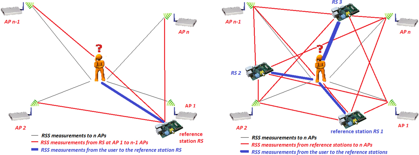
Hence, lateration algorithms are highly dependent on the accuracy of distance measurements, but accuracy degrades significantly due to the inherent detrimental effects of the Wi-Fi signals' indoor propagation. To overcome the drawbacks and limitations for RSS to distance conversion an approach based on the well-known DGPS principle is developed. We term this novel technique DWi-Fi. Using DWi-Fi, the RSS to distance relationship can be improved if range corrections are applied to the deduced ranges from the APs. They can be deduced if reference stations are deployed at certain AP locations or in the area of interest. Such a reference station measures the RSS to all other visible APs in the same way as the mobile user. The RSS and the deduced differential corrections are obtained from a comparison with the known ranges between the AP reference stations.
Figure 1 shows two different approaches for DWi-Fi. In the first case reference stations are deployed at certain Wi-Fi APs, i.e., at one AP as shown in the left-hand diagram. This reference station continuously measures the RSS to all other visible APs n-1. These measurements are used to derive range or coordinate corrections. At the mobile user, these corrections are applied to the current RSS observations to the corresponding AP for improvement of the localisation. In the second case shown in Figure 1, a network of several reference stations is deployed. As an example, three reference stations RS 1 to 3 are deployed at known locations. Then it is possible to derive area correction parameters (i.e., so-called Flächen-korrekturparameter FKP) in the reference AP network, in a similar manner as in Real-Time Kinematic (RTK)-GPS positioning in a Continuous Operating Reference Station (CORS) network. Radio maps of RSS distribution for the whole area of interest can be established to enable the deduction of the FKP. For that purpose, at least three reference stations are required as shown in Figure 1 (right). The FKP are then applied to the current RSS scans from the mobile user. Depending on the environment a log-distance or linear regression model can be applied for the RSS to distance conversion.
Two different DWi-Fi approaches with a single reference station (left) or a network of three reference stations (right).

A low-cost solution for the two DWi-Fi approaches is realised by using Raspberry Pi computers for the reference stations. Using a Universal Serial Bus (USB) Wi-Fi adapter plugged into the Raspberry Pi, RSS measurements can be performed similarly as at the mobile client. The Raspberry Pis are capable of scanning the RSS to all visible APs. For identification of a particular AP the MAC (Media Access Control) address is used.
3.2. DWi-Fi Evaluation Results
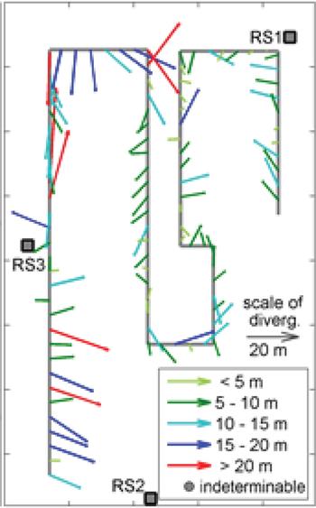
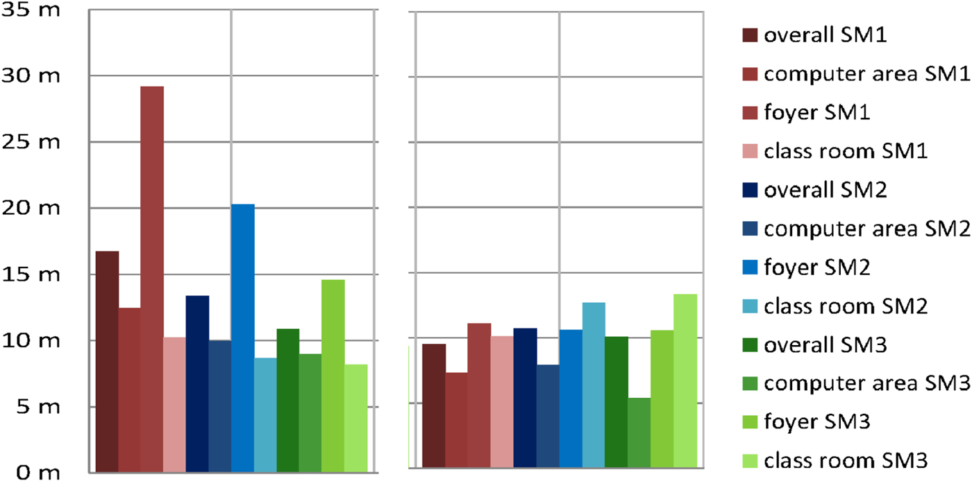
The major advantage of DWi-Fi is that the RSS to range conversion is based on range or coordinate correction parameters in the first approach and FKP in the second and not only on standard theoretical path loss models. First tests have shown that a significant improvement in terms of performance and positioning accuracies can be achieved using this novel approach (Retscher and Tatschl, Reference Retscher and Tatschl2016a). Figure 2 presents a kinematic positioning solution for a moving user along a 150 m long trajectory. As expected, kinematic positioning is more challenging than localisation of a static user. When looking at the resulting deviations from the ground truth along the user's trajectory one can see that good results are achieved in the central area of the network of the three reference stations RS1, RS2 and RS3. The deviations are less than 5 m. Within the tests it could also be demonstrated that the resulting positioning errors are in the same order of magnitude as for static positioning. This is also proven if one looks at the results for static positioning of three different smartphones in the test area presented in Figure 3. For comparison the positioning results of a common logarithmic path loss model for RSS to range conversion, i.e., the so-called one-slope model, is also shown in Figure 3. The maximum deviations from the ground truth are shown as a bar graph and they are illustrated with different colours and colour shades. In addition, the overall deviations in the whole area of the test site are also presented. As can be seen, a significant increase of positioning accuracies is achievable if the DWi-Fi approach is employed. The chosen test site is very challenging and was divided into three different areas, i.e., an area with desktop computers, a foyer and a classroom. Significant differences in the deviations, however, can be seen for the different areas; in the foyer, the worst results are obtained. The reason for this result is that an entresol exits in the foyer and thus the ceiling height is lower than in the other areas of the test site. If one looks especially at smartphone SM1 it can be seen that the deviations are significantly reduced if differential corrections are applied. Further test results can be found in Retscher and Taschl (Reference Retscher and Tatschl2016b).
Deviations of the differential approach solution from the ground truth for the user's trajectory in the test site.

Comparison of the maximum deviations of the position estimates using the one-slope (left) and the differential approach (right) for three different smartphones, SM1 to SM3, for static positioning.

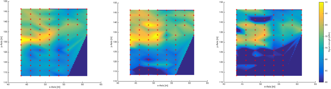
The results demonstrate that the DWi-Fi solution outperforms common lateration approaches where the ranges between the APs and the user are derived by simple logarithmic path loss models. Radio maps of RSS distribution for the whole test area in the study are derived to be able to deduce the FKPs. As an example, Figure 4 (left) shows an example of a radio map for one time epoch of smartphone SM1 for a certain AP which is located in the classroom (Retscher and Roth, Reference Retscher, Roth, Gartner and Huang2017). For the derivation of this radio map a network of at least three reference stations is needed. One can clearly see that regions of higher RSS are found in a rectangle which spatially matches with the classroom. The RSS values are much lower behind the walls in the foyer than in the room. Apparently, the classroom's walls damp a high percentage of the signal. Thus, a strategy for the derivation of real-time corrections for the RSS fingerprints measured at the mobile client is developed. Using such an approach, a significant improvement of the positioning accuracies for the mobile client is achieved. Temporal variations of the RSS are considered as continuous RSS measurements in the developed DWi-Fi approach. It is then possible to distinguish between different time epochs with different conditions, e.g. different numbers of people in the building when measuring during the day and at night. For comparison, the deduction of radio maps from the measured RSS values in the test site and their application for Wi-Fi positioning in a dynamically changing environment is further discussed in Retscher (Reference Retscher2017).
Example of radio maps for a certain AP in the classroom of the test site at two different epochs for smartphone SM1 (left and middle) and for a second smartphone SM2 at epoch 1 (right).

It can be surmised that it is possible to reduce the signal fluctuations and noise in real-time if dynamically updated radio maps of the area of interest are derived. In location fingerprinting, radio maps of RSS distribution at a certain time epoch are obtained in the training phase. This is very computationally intensive as a large number of reference RSS measurements need to be carried out on known points usually distributed in a rectangular grid in the area of interest. Furthermore, the training measurements need to be repeated if the environment changes. These radio maps cannot account for short-term variations of the signal. Therefore, in the new concept the radio maps are always determined and updated in real-time from the reference station measurements. The two radio maps in Figure 4 on the left and middle have been derived at two different epochs with a time interval of one hour between them. As can be seen, the RSS distribution has changed and the signal strengths are significantly higher in the classroom in the surroundings of the selected AP in the second epoch.
Furthermore, the RSS values in the radio maps depend on the hardware of the mobile device. Figure 4 (right) shows the radio map of a second smartphone SM2. The RSS values are not that distinctive, differing from smartphone SM1. They are much smaller in the foyer outside the classroom. This dependence on the mobile device used can be reduced if the radio maps derived from the Raspberry Pi units are used. A requirement is that the device must be calibrated and the relationship of the RSS scans between the mobile devices and Raspberry Pi units at the reference stations must be empirically defined (see Retscher, Reference Retscher2017).
3.3. Novelty and Delimitation of the DWi-Fi Approach
A Chinese patentFootnote 1 was announced in September 2013 describing a differential approach for Wi-Fi positioning. It is claimed that a significant increase in positioning accuracy is achievable with location fingerprinting. The newly developed DWi-Fi localisation approach presented in this study is different to the concept in the patent in several aspects. First of all, it is based on lateration and not fingerprinting. Fingerprinting requires a labour-intensive workload for establishing a database of RSS fingerprints in the area of interest. For that purpose, substantial training phase measurements need to be carried out where, usually, RSS measurements are performed in a regular grid in the building. To achieve suitable positioning accuracies, at least at the room level resolution the grid points must be very dense. This is not required for lateration. Hence, this positioning method was chosen and refined. Furthermore, in the new approach, the differencing is done on the level of the RSS measurements of the Raspberry Pis serving as reference stations as well as APs at the same time, and the mobile devices of the users. This realises a very low-cost solution. Due to a network of reference stations a more robust positioning solution with higher accuracy and integrity is achieved. The Chinese patent also claims that the approach is based on DGPS. A network-based solution, however, has not been patented. Also no server/client solution has been chosen as the user's privacy cannot be guaranteed if the calculation of the position of the user is performed on a server. Hence, it would be possible to track the user, which is not foreseen here due to data protection rights. In contrast to the Chinese patent solution the location determination is performed in real-time using a developed App on the user's mobile device and the user has to always give his consent if his position information is used for other purposes, e.g. for providing help and guidance for other App users.
In Chang et al. (Reference Chang, Rashidzadeh and Ahmadi2010) another differential approach for Wi-Fi positioning has been proposed. This approach differentiates between the novel approach developed in this study in similar aspects to the Chinese patent. Chang et al. (Reference Chang, Rashidzadeh and Ahmadi2010) also use location fingerprinting as the preferred positioning method. Thus, the same advantages of our approach are applicable as stated above. Using the novel approach presented here, generation of a radio map is also possible without labour intensive training measurements (see Section 3.2). Chang et al. (Reference Chang, Rashidzadeh and Ahmadi2010) employ a single pair of APs instead of a network of reference stations. The authors believe that only one dual AP is insufficient for large areas of interest. Such an approach provides only similar results with acceptable positioning accuracies in close proximity to the dual APs.
Moreover, a combination with RFID is proposed in this study to improve redundancy and integrity of the positioning solution. This principle is described in the following section.
3.4. RFID Virtual Gates Realisation
To further improve the accuracy and coverage of the localization of a mobile user, DWi-Fi will be combined with RFID technology. RFID will be used to define so-called virtual gates.
A typical RFID system consists of three components, namely a transponder or so-called tag (usually located on the object to be tracked), an interrogator or reader (which receives the information from tags) and a control unit (which operates the system and processes the information). For further information on RFID basics and an overview of operational principles for localisation the reader is referred to Retscher et al. (Reference Retscher, Zhu, Zhang and Chen2012).
For location determination, one conventional strategy is that RFID tags are placed as active landmarks or at known locations in the surrounding environment. If the user passes by with an RFID reader, the tag ID and additional information (e.g. the 3D coordinates of the tag) are retrieved. Thereby the range between the tag and the reader in which a connection between the two devices can be established depends on the type of the tag. This method is usually referred to as the direct approach. An alternative strategy used for RFID positioning is that readers are installed at certain waypoints in the surrounding environment (e.g. entrances to buildings, storage rooms, shops, etc.) to detect a person when passing by. For that purpose, an RFID tag is carried by the user to be located. This method is called a reverse approach.
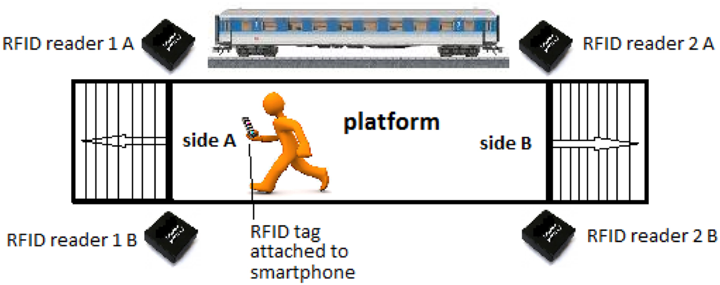
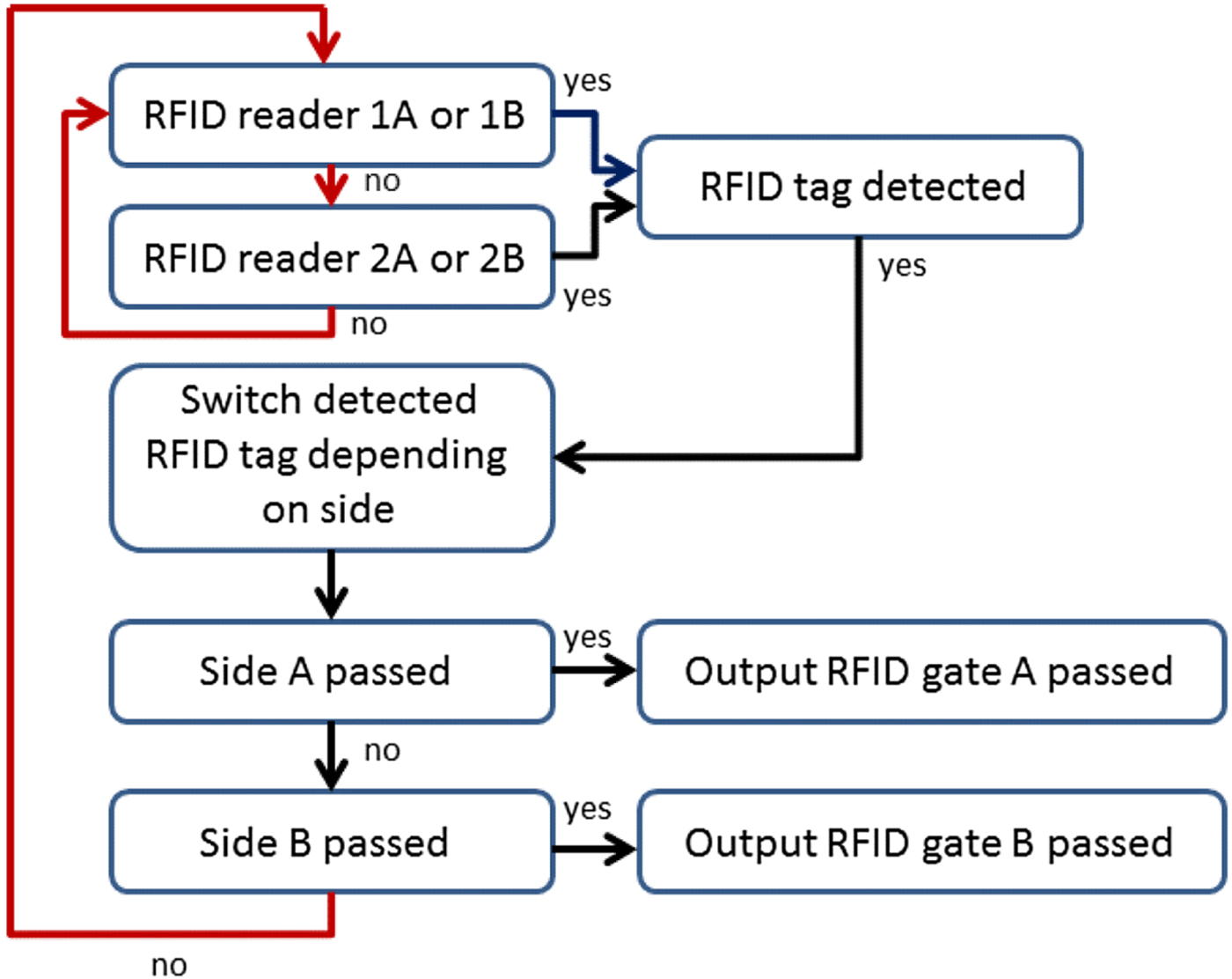
In our application, the reverse approach is realised. At critical transit passages throughout a station RFID readers are installed at fixed, known locations defining these as virtual gates. The mobile user is equipped with a low-cost RFID tag, attached, for instance, to his smartphone. If the reader detects a tag of a user a passage through the virtual gate is detected, i.e., the location of the user is then known. In an implementation, we use two RFID readers to represent a virtual gate at one platform entrance or exit. Figure 5 shows an example of how the RFID readers can be deployed. Then, a simple logical query regarding the sequence of tag detection yields the movement direction (see Figure 6). We propose four readers instead of just two for one platform with two entrances or exits due to the fact that the achievable range of readers situated only on one side of the entrance or exit would not be sufficient compared to the typical width of the virtual gate. Aside from that, another user passing by could lead to shadowing of the readers and further decrease the reading range. The implemented logical query can be extended in a further step using the measured signal strength values, RSS, of the RFID tags. Then the range from the tag to a reader can be deduced using a path loss model similar as is done for Wi-Fi.
Virtual gates at platform exits with four installed RFID readers.

Flowchart of logical sequence for RFID tag detection at a virtual gate.

Using such virtual gates as a secondary positioning technology a redundancy for the localisation of a passenger in the station can be achieved. Together with DWi-Fi, RFID is then integrated into one positioning solution. Moreover, a CP solution is performed for the localisation of the whole user group.
3.5. Intelligent CP Concept
In the following, only the principle of CP is briefly reviewed and the intelligent concept introduced. The CP concept for multi-modal transit situations is described in detail in Retscher and Obex (Reference Retscher and Obex2015).
CP is a further development of the multi-sensory approach and is the method for determining the location of groups of user absolute position and position relative to each other. Thus each user can be equipped with a variety of sensors, such as GNSS receivers and inertial sensors, of different performance and positioning accuracies. Thus, a network of individuals or a group of multiple users is located and navigated together and they share their information by using combined useful sensor observations. Between the different users, so-called inter-nodal ranging measurements are performed to be able to form a joint position solution (see e.g. Grejner-Brzezinska and Toth, Reference Grejner-Brzezinska and Toth2013; Kealy et al., Reference Kealy, Retscher, Toth, Hasnur-Rabiain, Gikas, Grejner-Brzezinska, Danezis and Moore2015).
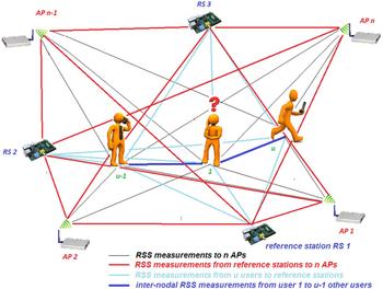
Figure 7 shows the intelligent CP approach for the application in this study. The inter-nodal RSS measurements between a user 1 and u-1 other users necessary to calculate a CP solution can also be made using Wi-Fi. The user who needs assistance can enable the hotspot function of his or her smartphone and then the other users can measure the ranges between them. Using these measurements, the combined CP solution can be calculated by the user. As described in Section 3.1, RSS measurements to the Wi-Fi APs and the other users are converted into ranges and the current location of the client user is obtained with lateration.
Intelligent CP concept in a network of reference stations.

Through the use of DWi-Fi and RFID for intelligent CP a novel localisation approach is developed. The first test results presented in Retscher and Tatschl (Reference Retscher and Tatschl2016a) showed that the derivation of range corrections from the differential solution and determination of potential offsets between different mobile devices leads to a significant improvement for the RSS to distance conversion. Thus, a better result in terms of performance and positioning accuracy for Wi-Fi lateration is obtained. Further testing of the approach was recently conducted at the TU Wien – Vienna University of Technology and the University of Melbourne. In these tests, Ultra-Wide Band (UWB) devices were used as stationary and mobile nodes in the CP solution. Their integration further strengthens the CP navigation solution. The evaluation is still ongoing and first results will be presented at the ION GNSS + 2017 conference in September 2017 in Portland, Oregon, USA (Retscher et al., Reference Retscher, Hofer, Kealy, Gikas and Obex2017).
Additionally, the accelerometer and compass readings from the smartphone inertial (or motion) sensors are recorded on the mobile device. Due to step counts using the accelerometers and heading measurement with the gyros and compass, the trajectory of the user can be continuously obtained using Dead Reckoning (DR). Retscher and Hofer (Reference Retscher and Hofer2017) employed these smartphone sensors in combination with Wi-Fi location fingerprinting. Due to their use, a reduction of the training measurements is achieved while performing continuous measurements of the moving user. Reference points are selected only on meaningfully distinguishable waypoints along the trajectory. Retscher and Hofer (Reference Retscher and Hofer2017) refer to them as intelligent checkpoints (iCPs). Due to their intelligent selection, it is not necessary to perform training measurements on reference points distributed in a regular grid. Thus, the required training phase workload is further reduced by 75%. When combining the iCP concept with DWi-Fi lateration it is possible to establish these iCPs for correction of the drift rates of the smartphone inertial sensors. Positioning accuracies of better than 2 m on average were achieved. For further information about their integration and the results the reader is referred to Hofer and Retscher (Reference Hofer and Retscher2017).
4. SOCIAL AND ETHICAL ASPECTS
In the sociological part of the research project people of all ages, including youngsters as well as elderly, are integrated in the development and testing. A special emphasis is made on elderly people who are capable of using a mobile device (i.e., a smartphone or tablet) and the software to be developed for it. In the following, the objectives of the study in respect to social and ethical aspects and the methodical approach are discussed.
4.1 Basic ethical aspects
The basic ethical question refers to data protection and data security in the present study. In the 1990's Cavoukian (Reference Cavoukian2009) formulated seven basic principles for ‘Privacy by Design’ (PbD) in localisation research for the protection of the privacy of users. It concerns:
-
• Privacy embedded into design as an integral part of the system without diminishing functionality;
-
• Privacy as the default setting by ensuring that personal data are automatically protected;
-
• Full functionality seeking to accommodate all legitimate interests and objectives in a positive-sum ‘win-win’ manner;
-
• Proactive rather than reactive measures to anticipate and prevent privacy invasive events before they happen;
-
• Visibility and transparency assuring all stakeholders that the operation is according to the stated promises and objectives, subject to independent verification;
-
• End-to-end security ensuring that all data are securely retained, and then securely destroyed at the end of the process, in a timely fashion; as well as
-
• Respect for user privacy to keep the service user-centric.
Concerning the technological aspects, the method of CP and its integration with DWi-Fi and RFID are used and employed in such a way that only anonymous measurements of the RSS between the infrastructure and the whole user group are considered for localisation determination. Moreover, the use of personal data is explicitly not foreseen. Thus, the privacy of all involved partners is protected. Also in the determination of movement patterns, no data referring to a certain person is collected or logged. As mentioned, the use of legally protected, sensitive data, for example mobile or cellular phone information, is explicitly not foreseen. Hence, the following ethical aspects are central in the system development and use:
-
• Transparency involving a clear statement of the research purposes, the use, evaluation, storage location, storage duration, etc., of the collected data in an ‘informed consent’ to all users,
-
• Data control where users can switch on and off data transfers from their own smartphone independently, delete data and understand the data, and
-
• Thriftiness for restriction of the collected data at the minimum level necessary.
Because of the fact that the end-users of all age groups are involved during the whole research procedure, other ethical questions can be picked up as a central theme when necessary.
4.2. Methodical approach
So that technological innovations become social innovations, i.e., that change human behaviour patterns, they require the integration of the targeted end-user group into the technological developments. This statement in particular shall be addressed. Timely integration of the end-users serves to positively influence the perceived added value of the utility as well as the perceived simplicity of a CP service. Such an integration also clears up data protection doubts (Jonuschat et al., Reference Jonuschat, Zinke, Bock, Schelewsky, Jonuschat, Bock and Stephan2014). To guarantee this integration different attempts have been developed in social science research. Examples are action research, participative development or user-centred design (Schuler and Namioka, Reference Schuler and Namioka1997; Haklay and Nivala, Reference Haklay, Nivala and Haklay2010). However, these often do not produce the desired results because of the lack of openness, process orientation and everyday familiarity (Comyn et al., Reference Comyn, Olsson, Guenzler, Ozcivelek, Zinnbauer and Cabrera2006). An approach which integrates targeted end-users and researchers equally into the development process is represented by Living Labs. This concept was developed and then applied to test user acceptance of smart homes. Since 2009 the European Commission has supported the use of Living Labs especially in smart cities research (Cossetta and Palumbo, Reference Cossetta, Palumbo, Dameri and Rosenthal-Sabroux2014). Thereby, potential end-users are not only discussing technological innovations but also trying them out themselves in their social environment and developing them with the involved scientists, companies and/or political stakeholders. In focus groups and Living Labs the following is investigated (after Wanka, Reference Wanka2014):
-
• Which level of knowledge different user groups have about the transference of their data on their smartphone and which way transparency can be created for them (e.g., in technological blogs, new media, senior citizens' pensioners' clubs);
-
• Which data different user groups are ready to reveal, what this readiness depends on and whether differences exist in data and transference methods;
-
• What benefit do different user groups expect for the supply of their data; and
-
• With regard to sensitive data a whether safe and secure solution, from the user's point of view, can be found (e.g. passwords, self-exclusion, encoding).
5. FURTHER DEVELOPMENTS
With traffic infrastructure variety, further information may be provided to the user, for example, interesting and relevant information for a tourist with regard to points of interest, cultural and other events, etc. For instance, this additional information can be provided while navigating and guiding a visitor to a city from the airport to his or her accommodation. Such a service can be achieved in cooperation with tourism associations, event organisers, etc. These suggestions may be adapted depending on the current weather situation and/or season of the year. Then, for a tourist, information and navigation to current exhibitions, museums, etc. may be provided in the case of bad weather or in winter. Another example would be that the service offers flight departure information for a person who is on the way to the airport.
Existing applications can be integrated into the concept and extend functionally. In Vienna, the routing service of the public transport authority (Wiener Linien) ‘qando’ is a suitable candidate for integration and enhancement. Then the service can also contribute interactively to real-time navigation in addition to giving directions on how to get from A to B. For example, it is then possible to provide information on which exit one has to take from the underground or metro line to reach the connection to the next means of transportation in the shortest time.
The service represents an enhanced utility for a smart city and therefore has potential for worldwide application. The increased use of public transportation and other means of transportation, such as the use of city bikes, could lead to a significant reduction in car traffic.
6. CONCLUDING REMARKS AND OUTLOOK
In this paper, a service is discussed which provides assistance for public transport users at multi-modal transit interchanges. Intelligent CP is applied to locate an individual user who needs assistance with the help of other users. Then, improved passenger assistance and guidance can be achieved. As there is still limited understanding of people's behaviours in transit situations the study can be seen as a major contribution to improving passenger movement in such situations. Due to an increase in performance and positioning accuracies using the novel CP solution the tracking of (groups of) service end-users is possible and real-time passenger guidance in multi-modal transit situations is enabled.
It is a matter of fact that existing solutions and research on multi-modal transportation mainly focuses on routing at the macro-level, e.g., computing a route from a start point A to a destination B. However, in reality, especially in very large multi-modal transit stations, passengers still have many difficulties in finding or reaching their connecting train, underground or metro line, bus, etc. This is mainly due to the lack of real-time transportation information. A major improvement of the indoor positioning and tracking accuracy is required and it is elaborated in this paper that a CP approach can fulfil this requirement. Furthermore, deriving movement patterns, and developing guidance systems for transit stations is a necessity. Finally, it can be concluded that – in the course of the described contributions – the suggested guidance service can be seen as part of further development of smart cities where a priority aim is that public and other means of transportation, apart from car traffic, are increasingly used.