Crow Tribal Historian Joseph Medicine Crow first reported buffalo jumps in the Grapevine Creek drainage basin (GVC) at the Montana Archaeological Society's Buffalo Jump Symposium in 1961. His report was based on oral traditions he recorded from generations of ancestors (Malouf and Conner Reference Malouf and Conner1962; Medicine Crow Reference Medicine Crow, Malouf and Conner1962). Medicine Crow described jump sites and drivelines assumed to have been associated with bison hunting, but until the 2015 field season, researchers had been unable to confirm the function of these sites by locating either the bonebeds or associated camps (Conner Reference Conner1964, Reference Conner1969; Walker-Kuntz Reference Walker-Kuntz2005). The lack of bison remains at the postulated GVC jump sites raised some questions about whether these sites were actually jumping complexes (Walker-Kuntz Reference Walker-Kuntz2005). In addition, questions related to the temporal resolution of landscape use and site occupation at GVC remained unanswered. In order to investigate these questions in preparation for a possible district nomination to the National Register of Historic Places (NHRP), the Crow Tribal Historic Preservation Office (CTHPO) initiated this project to inventory prehistoric archaeological sites in the GVC. The project included input from the Crow Cultural Committee (an elected tribal governing body), as well as the participation and training of CTHPO cultural inspectors.
The GVC is important to both the prehistoric and contemporary Crow culture. The landscape provides a unique opportunity to integrate indigenous knowledge and oral traditions with archaeological methods to better understand the complex and dynamic role that the GVC played within northwest Plains cultures. Bacheeishdíio, (“Place Where Men Pack Meat”) is the Crow name for the GVC in southern Montana, on the Crow Reservation. For Crow people, Bacheeishdíio is just one part of a larger cultural landscape, bounded on the south and east by the Bighorn River, (Iisaxpúatahcheeaashe), southwest by the Dryhead drainage, (Aashúuchoosalaho), and west by Little Mountain, (Awaxaawiakáate). It is a land known for its abundance of game and edible and medicinal plants (Medicine Crow Reference Medicine Crow1992:89). The GVC represents a microcosm of archaeological site types on the northwest Plains; archaeologists have previously recorded cairn lines, habitation sites, chert extraction locales, hunting camps, prehistoric trails, battlegrounds, and a rock art site (Conner Reference Conner1964, Reference Conner1969; Conner and Conner Reference Conner and Conner1971; Loendorf and Good Reference Loendorf and Good1977; McCleary Reference McCleary2015:60–61; Medicine Crow Reference Medicine Crow1978; Walker-Kuntz Reference Walker-Kuntz2005).
Crow oral traditions and previous archaeological research generated the CTHPO interest in the GVC and helped formulate the primary research questions focused on chronology and cultural affiliation pursuant to a NRHP district nomination. We combined oral traditions (McCleary Reference McCleary2010; Medicine Crow Reference Medicine Crow, Malouf and Conner1962, Reference Medicine Crow1992) and archaeological landscape features (Conner Reference Conner1968, Reference Conner1969; Good and Loendorf Reference Good and Loendorf1974; Walker-Kuntz Reference Walker-Kuntz2005) with a perspective informed by geoarchaeology in an attempt to locate preserved bonebeds. Archaeological features near cliffs or steep slopes above colluvial or alluvial deposits provide the framework for a simple predictive model that may help locate preserved bonebeds. While focusing on locales identified by this model, we located two buffalo jumps with associated bison bones.
This paper takes a holistic approach to evaluate multiple lines of evidence associated with buffalo jumps and communal bison hunting in the northwest Plains. Results of this project demonstrate the advantages of community-based participatory research, which integrates stakeholder knowledge and local research initiatives with oral traditions (Atalay Reference Atalay2012) and conventional archaeological and geoarchaeological methods to accomplish both community development and scientific research goals. The data generated provide a new perspective on the GVC buffalo jump complex and the Crow cultural investment associated with bison hunting. Additionally, this project expands the CTHPO capability to perform cultural resource management operations by providing training for tribal cultural inspectors who participated in much of the fieldwork reported in this paper.
Bacheeishdíio and Crow Oral Traditions
Crow oral traditions combined with interviews of tribal historians (McCleary Reference McCleary2010, Reference McCleary2012; Medicine Crow Reference Medicine Crow, Malouf and Conner1962, Reference Medicine Crow1978, Reference Medicine Crow1992) provided an indigenous perspective on the GVC landscape. Because the GVC drainage basin was an important landscape for communal hunting and resources, it features prominently in Crow oral traditions that recount the people, flora, and fauna in the region. The spoken histories provide ethnographic accounts of bison hunting and stories relating the origins of the dramatic landscape. Spoken histories often use dramatic or culturally important landscape features to help narrators remember specific people and significant events (Echo-Hawk Reference Echo-Hawk2000; Oetelaar Reference Oetelaar2006), and the GVC landscape, people, and events are referenced in a number of oral traditions (Medicine Crow Reference Medicine Crow, Malouf and Conner1962, Reference Medicine Crow1978, Reference Medicine Crow1992).
One story describes how the red color in the cliffs of the Chugwater Formation above the GVC is from the blood of a mythical tyrant named Red Woman. At the conclusion of the narrative, she was camped by the creek gathering food when she was approached by the Divine Twins, Thrown Into The Spring and Thrown Behind The Tipi Curtain. She knew they had come to avenge the murder of their mother. She tried to pacify them by offering them boiled buffalo ribs, but they ignored her pleas. Thrown Behind The Tipi Curtain then shot her with an arrow and, as she fled, Thrown Into The Spring slashed at her with a knife. Her blood spilled throughout the drainage staining the cliffs red (McCleary Reference McCleary2012:64; Old Coyote Reference Old Coyote and Smith1995:35).
In another mega-narrative, the origin of buffalo jumps is recalled. In this story, Old Man Coyote, the trickster-hero, is said to have shown Crow people how to get bison to go over a cliff. In a conversation with two bison bulls, he talks them into a race. He designs the course so that it goes into the setting sun and over a cliff. In that way, the bulls will be blinded and will not see that they will run off a cliff edge. Old Man Coyote starts out in the race with the two bulls, but feigns a sore leg. The bulls race past him and go over the cliff, which kills them both (Linderman Reference Linderman1996:91–93). According to the elder Marvin Stewart, who related this narrative, “We don't know if that happened here (at Grapevine), but when we see these (buffalo) jumps, it reminds us of that story” (McCleary Reference McCleary2005:12).
In clearly historical terms, Crow oral tradition relates that the fifth principal leader or head chief, Running Coyote, received instructions in a dream on how to operate a buffalo jump (Medicine Crow Reference Medicine Crow1978). This undoubtedly meant that he was given some type of spiritual power or medicine, which he used to cause the bison to go over the cliff (Curtis Reference Curtis1976:45). The Crow people believe that the organizers of buffalo jumps often received a form of spiritual assistance. Some were so powerful that any animal that came into the drivelines was forced to go all the way through, even birds flying in the sky (Taylor Reference Taylor1962:41). Minnie Williams, a Crow woman who had participated in buffalo jumps as a child, recalled, “One person lay behind each pile of rocks and sprang up waving a blanket as the stampeding herd came abreast. The tribe was not overly concerned about being trampled because the medicine man gave his protection to the tribe before the run began” (Conner Reference Conner1960:1).
These and similar oral traditions foster a Crow group identity firmly rooted in the GVC landscape. This, in turn, serves as a form of institutional memory for the Crow people and creates a collective feeling of permanence in the region (Zedeño et al. Reference Zedeño, Ballenger and Murray2014). The buffalo jumps and surrounds were important to the Crow way of life in the past, and their tangible presence on the landscape of GVC offers modern Crows and researchers an opportunity to share in that past. In the collective memory of Crow people today, the creation and use of the GVC is tied to mega-narratives from the distant past.
Previous Research at Grapevine Creek
After the 1961 Buffalo Jump symposium (Medicine Crow Reference Medicine Crow, Malouf and Conner1962; Malouf and Conner Reference Malouf and Conner1962), archaeologist Conner began investigating the GVC buffalo jumps with the help of Joseph Medicine Crow (Conner Reference Conner1964), and Smithsonian numbers were assigned to five possible buffalo jump sites. Conner located three drivelines that led to cliffs, and at one site (24BH265), Medicine Crow pulled a long bone from Grapevine Creek cutbank sediments beneath the cliff. Conner placed other possible buffalo jump sites on topographic maps according to information provided by Medicine Crow; however, some recorded sites were neither visited nor located, and no bison bones were recovered from any other site (Conner Reference Conner1964).
Fifty-seven previously identified archaeological sites have been located in the GVC since Conner's original visit. The site types include possible buffalo jumps, drivelines, burials, fortified battlefields, stone circles, lithic debitage concentrations, and a historic trail. Good and Loendorf worked extensively in the area and reported most of the sites in the drainage (Good and Loendorf Reference Good and Loendorf1974; Loendorf Reference Loendorf1973; Loendorf and Good Reference Loendorf and Good1977). Relocating the sites since then has proven difficult. Except for 24BH262, where drivelines remain intact and clearly lead to an obvious precipice, the precise locations of other buffalo jumps at GVC were difficult to assess because the drivelines have been disturbed by looting, construction, and ranching activities (Walker-Kuntz Reference Walker-Kuntz2005). Additionally, some site locations have been described only generally, or were mapped in multiple locations (Conner Reference Conner1969).
Physical Geography and Environmental Setting
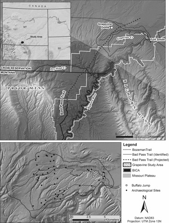
The 12-km-by-6-km drainage basin was an important hunting ground in prehistory because it is well situated between different physiographic regions. The basin is located in an ecotonal landscape of the Interior Plains region north of the Bighorn Canyon National Recreation Area between the Pryor Mountains and the Missouri Plateau (Fenneman Reference Fenneman1931; Landt Reference Landt2008; Richards Reference Richards1955; Figure 1). The major local landscape features at GVC include dozens of cliff exposures and the bedrock-controlled Bighorn River, which has carved a 250-m-deep by 700-m-wide canyon as it traverses the southeastern portion of the basin. As evidenced by numerous regional faults and folds, significant tectonic activity has created a dramatic landscape (Lopez Reference Lopez2000; Richards Reference Richards1955). The GVC sits approximately 150 m below the surrounding landscape, while Grapevine Creek meanders through the floor of the basin.
The Grapevine Creek study area.

The GVC is an upland plain dissected by several drainages fed by snowmelt, localized precipitation and runoff, and freshwater springs (Good and Loendorf Reference Good and Loendorf1974). The National Park Service reports average annual precipitation at the nearby Yellowtail Dam ranges between 38–45 cm, making water a primary limiting factor for this ecosystem (Gray et al. Reference Gray, Fastie, Jackson and Betancourt2004; Rowe Reference Rowe2014). The distribution of vegetation within the drainage is dependent on the proximity to water sources, protection from insolation by physical features, and elevation, which follows patterns observed in other regional locales (Frison and Todd Reference Frison and Todd1986; Rowe Reference Rowe2014).
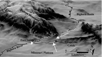
The vegetation, topography, and physiography of the GVC are particularly well suited for bison, and bison hunting. The GVC is a grassland zone dominated by a variety of grasses, greasewood, sagebrush, and rabbitbrush (Porter Reference Porter1962), which provide good grazing opportunities for bison and other large herbivores. Natural corridors for human and faunal migration between different physiographic regions are present at three locations on the landscape surrounding the basin (Figure 2). The only Bighorn River ford for over 40 km is situated near the confluence of Grapevine Creek and the Big Horn River at Fort Smith (constructed to protect the crossing of the historic Bozeman Trail before it continues west through the GVC and Pryor Mountains (Davis and Zeier Reference Davis and Zeier1978; Nickels Reference Nickels2003). Throughout history, this river crossing would have been an important landmark for migrating people and herd animals. Similarly, another route of entry into the basin is positioned in the southwestern portion of the GVC, between the Pryor Mountains to the west and the Bighorn River. This pass likely represents the northern extension of the north-south oriented prehistoric Bad Pass Trail (Bearss Reference Bearss1970:467) and may represent a buffalo trace (Loendorf Reference Loendorf1980). Loendorf (Reference Loendorf1980:67) references observations recorded in the 1866 diary by George M. Templeton of Native Americans emerging from the Bad Pass Trail across the river from Fort Smith. Along the eastern flank of the Grapevine Dome in the northern portion of the drainage, a shallow saddle creates a passageway between the GVC basin and the grasslands of the Missouri Plateau.
Three-dimensional view of the Grapevine Creek drainage basin facing south. Note three natural travel corridors into the basin, as indicated by white arrows.

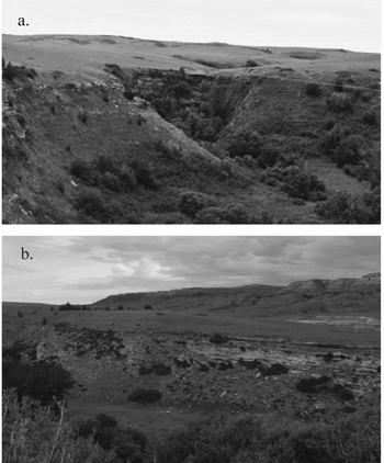
Regional uplift and erosion have created 5- to 25-m-high cliffs and steep slopes that flank the creek at the valley margins (Figure 3). Tributaries to Grapevine Creek have eroded ephemeral drainages that gently slope toward the cliffs along the creek, providing a natural path for both water and bison. A long history of erosion has resulted in bedrock exposures and cliffs comprised of sandstone with interbedded limestone, quartzite, and bedded and nodular chert along much of the GVC (Lopez Reference Lopez2000; Vuke et al. Reference Vuke, Wilde, Lopez and Bergantino2007).
The Grapevine Creek buffalo jump topography: (a) Valley wall of Grapevine Creek with grasslands on benches above cliffs and steep slopes. View facing south; (b) Chugwater Formation at top of image and Grapevine Creek valley wall in center. Note colluvium at base of cliff. Grapevine Creek (not visible) flows in foreground. View facing north.

The vivid red colors of the Chugwater Formation can be seen above the valley floor in the northeastern corner of the study area (Alt and Hyndman Reference Alt and Hyndman1986; Lopez Reference Lopez2000; Vuke et al. Reference Vuke, Wilde, Lopez and Bergantino2007) and within the GVC floodplain alluvium and alluvial fans in the eastern portion of the basin. GVC floodplain soils are typically deeper than those on the benches, well drained, and are not well developed (Soil Survey Staff 1999). In portions of the buffalo jump study area, A-C-Ab-Cb soil horizonation indicates weak pedogenesis, young soils, and paleosol burial. These stratified loams suggest that flooding occurs at rates that can outpace pedogenesis, and that archaeological sites may be present in buried, stratified contexts. Older stratigraphy is also buried under steep landscape positions in the GVC, where colluvial deposits or landslides occur. Such alluvial or colluvial burial of sites, together with Grapevine Creek meandering and erosion, has likely complicated site discovery in the GVC.
Methods
In 2014 and 2015, teams of CTHPO cultural inspectors, field school students, archaeologists, and a geoarchaeologist surveyed portions of the GVC to locate and record undocumented prehistoric sites as well as previously identified sites that lacked temporal or spatial data. We conducted a pedestrian survey that covered 4 km2 in two major portions of the drainage, and mapped each site encountered with a Trimble Yuma 2 sub-meter accuracy GPS unit. Because buffalo jumps are an important component of Crow oral traditions, but bonebeds had not yet been documented in the GVC, in 2015 we targeted steep colluvial slopes and cliffs with talus or landslide deposits comprised of relatively young soils (Entisols and Inceptisols) at their base in order to encounter deposits that can preserve archaeological remains through burial. In addition, we searched for landforms above the cliffs with natural topography (arroyos, tributaries, or ephemeral drainages) sloping toward the precipice of potential jump sites, and areas beneath cliff exposures proximal to identified archaeological sites or probable drivelines. This method led to the discovery of a bison bonebed, and one test excavation unit was opened at the edge of a site (24BH264) where bison bones were exposed by slumping and subsequent erosion.
We obtained archaeological site data from the Montana SHPO, published literature, and reports of previous investigations (Conner Reference Conner1964, Reference Conner1968, Reference Conner1969, Reference Conner and Conner1971; Good and Loendorf Reference Good and Loendorf1974; Landt Reference Landt2008; Landt and Alexander Reference Landt and Alexander2010; Loendorf Reference Loendorf1973; Loendorf and Good Reference Loendorf and Good1977; Walker-Kuntz Reference Walker-Kuntz2005). Previous research in the drainage is limited and derives largely from cultural resource management reports that identified archaeological sites along specific corridors scheduled for land disturbance. Few of these studies recovered temporally diagnostic artifacts. In order to visualize the context of known archaeological sites, we constructed a geographic information system (GIS) database of site locations, topography, digital elevation models (DEM), geology, soil, and other similar maps of the study area.
Analysis of the faunal materials from 24BH264 follows standard zooarchaeological methodology (Driver Reference Driver1992; Gifford and Crader Reference Gifford and Crader1977; Grayson Reference Grayson1979; Reitz and Wing Reference Reitz and Wing1999). For species identification, we relied on a six-year-old Bison bison specimen housed at the University of Arizona's School of Anthropology (BARA Lab) and reference material from the Stanley J. Olsen Zooarchaeology Laboratory (Adams and Crabtree Reference Adams and Crabtree2011; Gilbert Reference Gilbert1980). We sorted all recovered bone specimens into identifiable and non-identifiable materials, counted all of the fragments, and examined them for burning levels and butchery marks. We determined the total number of fragments and identifiable specimens for each of the arbitrary excavation levels, but calculations of the minimum number of individuals (MNI) aggregated the sample into one analytical unit to avoid overinflating the numbers in the small faunal assemblage (Marshall and Pilgram Reference Marshall and Pilgram1993).
Results
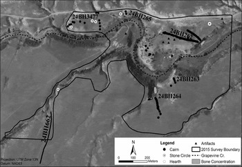
Figure 4 provides a detailed map of our survey work. Our team documented four stone circle sites, three chert quarry sites, and a number of locales with concentrations of chert debitage or isolated stone tools. We relocated and documented four sets of cairn drivelines, and confirmed the presence of two associated buffalo jumps. Importantly, we documented bone within colluvium under the 24BH262 drivelines, discovered a preserved and intact bison bonebed at the base of jump site 24BH264 in a remote portion of the GVC drainage, and placed a test excavation (Unit 15-01) along the periphery of the bonebed. The results that follow describe the buffalo jump sites documented during this research.
Map of archaeological sites in the Grapevine Creek drainage basin documented during the 2014 and 2015 field seasons.

Site 24BH262
Maps made by Conner (Reference Conner1964) facilitated our ability to relocate this jump site and associated cairn lines. We documented two drivelines composed of 93 cairns, a stone circle with hearth feature, several cairns apparently not associated with the drivelines, and three well-defined lithic debitage concentrations. The drivelines form a “V” with the vertex at the cliff margin. The southern driveline is approximately 260 m long, and the northern line length is 125 m. Natural outcrops of the Tensleep Formation occur at the surface, and inhabitants of the site clearly used the available tool stone. After mapping the site and creating a DEM of the locale, we realized that 24BH262 is the unnamed site described by Medicine Crow at the 1961 Buffalo Jump symposium (Medicine Crow Reference Medicine Crow, Malouf and Conner1962, Reference Medicine Crow1978). The site is unique in the GVC because bison could be driven to precipices either between two drivelines leading to an 18-m-high cliff or to another position along the same cliff between the southernmost driveline and a natural depression. We recovered a basalt Avonlea projectile point, which is often associated with bison hunting between A.D. 250–1200 on the northwestern Plains (Kehoe Reference Kehoe1966; Kehoe and McCorquodale Reference Kehoe and McCorquodale1961). Although we found many extensively weathered bone fragments on the surface of colluvium beneath the jump, time constraints and reported disturbance prevented us from excavating the site. Crow informant Martin He-Does-It suggested that the site was commercially mined for bone fertilizer because the site was easily accessible from the road (Conner Reference Conner1969:1). Commercial mining of bison bones for fertilizer was common in the early twentieth century (Davis and Zeier Reference Davis and Zeier1978).
Site 24BH263
Although we recorded a scraper and four cairns spaced 31 m apart on the grassland above the GVC valley, we cannot confidently conclude whether the jump was located east or west of the cairn line. If additional cairns were present in the driveline, power line construction in 2009 probably destroyed them (Landt Reference Landt2008).
Site 24BH264
In 1962, Medicine Crow described the location of this site as on the south side of Grapevine Creek along a cliff about 200 yards upstream from 24BH263 “at the head of an incipient tributary coulee” (Conner Reference Conner1964:3). Conner and his team finally visited the site in 1969 and documented part of the driveline, but were unable to find bison bones in the talus beneath the jump. In 2015, we relocated and documented a site we believe to be the one Conner reported. The jump is located on the eastern side of a horseshoe canyon on the south side of Grapevine Creek. Exposed cliffs rim the upper portion of the canyon, and, unlike the open grassland landscape above the cliff, the vegetation surrounding 24BH264 is dense. We located 62 cairns oriented south to north forming a driveline 135 m long above and leading to the jump (Figure 4). The ephemeral drainage west of the driveline apparently formed the western side of the driveline feature.
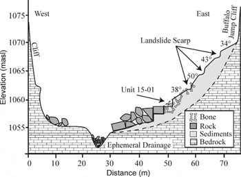
Test Excavation Unit 15-01. Sediments at the base of the jump contained bison bones eroding from a relatively recent slump. The bone deposits continued along the steep slope laterally for 21 m and extended uphill for approximately 17 m. The goal of the excavation was to document whether the bonebed was associated with human activity and, if so, to construct a chronology for the site. The 1-m-×-1-m unit was placed on a 38-degree slope in colluvial deposits approximately 20 m east of the intermittent drainage. Beneath the unit, erosion has removed most sediment, exposing bedrock and large boulders, suggesting that cultural and faunal remains in the path of the drainage have been removed. Unit 15-01 lies approximately 3 m above the floor of the drainage and has been preserved, in part, because boulders have trapped the bonebed and sediments above the drainage (Figure 5). Because of the presence of scarps on the talus slope and the A-C horizonation of soils 1 and 2, the depositional events that buried the bison bonebed are most likely the result of two different landslides.
Test Excavation Unit 15-01 canyon profile facing northeast. The bison bonebed is preserved through landslide burial and trapped between boulders downhill and valley bedrock underlying unconsolidated sediments. The ephemeral drainage has eroded to bedrock. (Vertical exaggeration = 2:1.)

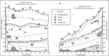
Unit 15-01 contained a three-tiered soil profile with bison bones present in each soil (Figure 6). The surficial soil and first paleosol encountered were young (Entisols) exhibiting A-C horizonation with weak pedogenesis, while the second paleosol showed somewhat more evidence of pedogenesis (A-Bw horizonation). Although not all the bones were burned, many of the bones in both paleosols were calcined and charcoal flecking was abundant. The poorly sorted sandy loam sediments derive from recent slopewash and older parent material found in the sandy sedimentary units of the bedrock cliffs above the unit. We also recovered two in situ Prairie Side-Notched type projectile points from unit 15-01 (38 cmbd and 90 cmbd). These projectile point types are common on the northwestern Plains between A.D. 700–1300 (Kehoe Reference Kehoe1966; Peck and Ives Reference Peck and Ives2001). We recovered chert flakes and possible butchering tools from soil 2.
Stratigraphy of test excavation Unit 15-01: (a) back wall stratigraphy; (b) side wall stratigraphy. Note three soils (two paleosols), each containing Bison bison bones. Soils 1 and 2 are entisols exhibiting A-C horizonation typical of immature soils. Soil 2 experienced burning prior to burial by soil 1, as did soil 3 prior to burial by soil 2. Although soil 3 was not fully excavated, it contains a Bw horizon, suggesting greater weathering, and perhaps a longer subaerial resident time.

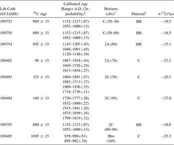
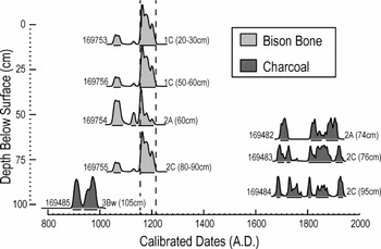
Radiocarbon age estimates obtained from bison bone and wood charcoal are listed in Table 1, and Figure 7 is the probability density diagram for the same dates. Bone samples derive from soils 1 and 2 because bone preservation in soil 3 was poor. The charcoal date from soil 3 (1095 ± 15 B.P., UCIAMS 169485; wood charcoal; δ13C = -25.3‰) may indicate that older bison bones are present in soil 3 beneath the floor of unit 15-01. Although the dates obtained from wood charcoal appear to be in stratigraphic order, the dates from bison bone confirm our interpretation that the sediments in Unit 15-01 are disturbed. The four bison bone dates are remarkably consistent and indicate bison jumping occurred during the Late Prehistoric period between about cal A.D. 1150–1215 at 24BH264.
Radiocarbon Age Estimates from Grapevine Creek.

1 Ranges < 5% probability excluded. Ages calibrated using CALIB 7 (Stuiver and Reimer Reference Stuiver and Reimer1993; Stuiver et al. Reference Stuiver, Reimer and Reimer2005); calibration based on IntCal13 calibration model (Reimer et al. Reference Reimer, Bard, Bayliss, Beck, Christopher, Ramsey, Buck, Cheng, Edwards, Friedrich, Grootes, Guilderson, Haflidason, Hajdas, Hatté, Heaton, Hoffmann, Hogg, Hughen, Kaiser, Kromer, Manning, Niu, Reimer, Richards, Scott, Southon, Staff, Turney and van derPlicht2013).
2 Soil horizon from which sample was obtained in Unit 15-01.
3 BB = bison bone, C = wood charcoal.
Calibrated 14C dates, Unit 15-01. Lab numbers to left of each date, soil horizon and depth to right. Ages are presented in stratigraphic order. Although the stratigraphy has been disturbed by landslide deposits, the consistent bison bone dates indicate that bison jumping occurred at 24BH264 sometime between cal A.D. 1150–1215.

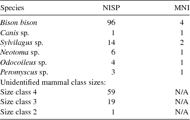
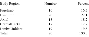
24BH264 Fauna. Although most of the 204 identifiable bones belong to Bison bison, we identified six species and three body size classes (Table 2). All of the non-bison species, especially the Peromyscus sp. and Neotoma sp. could be post-bonebed additions. We identified a single Canis sp. specimen in the assemblage. Seven hundred and eighty-five (38.6 percent) of the fragments were burned and located primarily within the two paleosols. Only four specimens have direct evidence of butchery or processing. We divided the Bison bison assemblage into body regions and found that 63.5 percent of the recovered fragments are from limbs and extremities, while the remaining 36.5 percent come from the axial skeleton and cranium (Table 3), suggesting that axial and cranial fragments should be more prevalent in our assemblage (Lyman Reference Lyman1984). The paucity of butchery marks and axial/cranial skeletal fragments may be a result of sample size, but it is also possible that most of the processing occurred at an alternative site. Also of note are two extremely large femurs (315 mm and 322 mm) found near the surface of the excavation and one large tibia (414 mm) recovered in situ.
Faunal Remains from 24BH264.

Bison bison Body Parts Present.

Site 24BH265
We located two cairns that we believe to be those described at 24BH265 but were unable to relocate features, bones, or artifacts that verify the site was used as a buffalo jump. Although Conner (Reference Conner1964:3) reported that Medicine Crow pulled a bison long bone from a cutbank of Grapevine Creek in 1962, if a jump site was present here Grapevine Creek meandering apparently removed the bonebed from beneath the cliff, while road construction and possible looting destroyed previously identified cairns from the bench above the creek (Conner Reference Conner1964, Reference Conner1969; Walker-Kuntz Reference Walker-Kuntz2005:20).
Site 24BH662
This site is comprised of 62 cairns in a south-north oriented driveline that extends at least 365 m. An unnamed ephemeral drainage with 2- to 5-m-high cliffs forms the western edge of the driveline. Like other ephemeral drainages in the GVC, the arroyo has experienced flash flooding that has removed most of the unconsolidated sediments and evidence of bison bones from beneath the jump. The driveline slopes gently downhill, leading to a 5-m-high jump. At this point, bison could have chosen a gentler path into the narrow arroyo that traverses 700 m before leading to Grapevine Creek. Bison in the arroyo would have been forced to run single-file along the length of the drainage and survive three small jumps (1–3 m high) before reaching the confluence of Grapevine Creek. Hunters along the edge of the arroyo would have had many opportunities to harvest bison from above. This jump complex may combine a buffalo jump with a buffalo trap at the confluence of Grapevine Creek.
Discussion
Prior to the introduction of the horse, bison hunting methods varied through time and space to include arroyo traps, various types of natural and built enclosures or surrounds, ambush hunting, and buffalo jumps (Forbis Reference Forbis1978; Kornfeld et al. Reference Kornfeld, Frison, Larson and Bradley2010; Reeves Reference Reeves1978; Wheat Reference Wheat1978). The buffalo jump is a unique type of bison hunting that was most common on the northwestern Plains, and is characterized as a location on the landscape where bison were stampeded over a cliff or steep slope (Medicine Crow Reference Medicine Crow1978; Verbicky-Todd Reference Verbicky-Todd1984). According to Crow oral traditions, successful jumps required that cliff exposures remain hidden from the bison herd by using natural landscape features or abrupt driveline turns to trick the herd over a precipice (Medicine Crow Reference Medicine Crow, Malouf and Conner1962, Reference Medicine Crow1978). This required tribal leaders to carefully orchestrate the placement of drivelines, habitation sites, and people in order to have the location of the coup de grace remain hidden from the herd (Carlson and Bement Reference Carlson and Bement2013; Frison Reference Frison1978; Zedeño et al. Reference Zedeño, Ballenger and Murray2014). Like at the GVC, prearranged cairn or brush lines, fences, or walls took advantage of the natural topography to direct bison herds to a targeted location where people could trap the animals or drive them over a steep drop.
The close proximity of 24BH262, 24BH264, and 24BH662 suggests that this GVC hunting strategy is an example of a buffalo-jumping complex. Jump complexes are often extensive archaeological landscapes that stretch beyond the jump itself and include clusters of associated sites, such as drive lines in the grasslands above the cliffs, a meat and hide processing area, and campsites nearby (Arthur Reference Arthur1966; Verbicky-Todd Reference Verbicky-Todd1984). Archaeological research on the northwest Plains provides evidence of intensified use of jumping complexes around 2,000 years ago (Brink and Dawe Reference Brink and Dawe2003; Kornfeld et al. Reference Kornfeld, Frison, Larson and Bradley2010). Similar to what we found at the GVC jump complex, hunting strategies became more complex and elaborate during the Middle and Late Prehistoric period when large communal hunts were organized using surround traps or multiple drivelines leading to multiple cliff exposures (Butler Reference Butler1978; Zedeño et al. Reference Zedeño, Ballenger and Murray2014).
Driveline preparation, hunting, and processing tasks required the participation of large numbers of people, and by the Late Prehistoric period (ca. A.D. 250–1700) archaeological evidence indicates that communal bison hunting was an important fall event (Frison Reference Frison1978; Oetelaar Reference Oetelaar2014). Crow tribal historian Charles Ten-Bear reported that the tribe would move to bison hunting grounds to conduct communal hunts in the fall (Medicine Crow Reference Medicine Crow1978). Preparations for winter were important to Plains groups, who relied on bison meat and the fall season provided advantages that other seasons lacked (Carlson and Bement Reference Carlson and Bement2013; Frison Reference Frison1978; Reher Reference Reher1978). Bison hides and meat are usually in prime condition during the fall, and bison herds are more predictable during this period (Frison Reference Frison1970a, Reference Frison1970b). For instance, during the spring calving season herds are less likely to be moved in any direction when cows become separated from their calves (Frison Reference Frison2004).
The Crow also hunted bison during the winter season when environmental manipulation was more difficult. One spoken history recounts the 200-year-old winter bison hunting techniques of Chief One Heart, who would organize fast runners to chase bison onto ice at watering holes where they were safely and effectively dispatched (Medicine Crow Reference Medicine Crow1978). Medicine Crow (Reference Medicine Crow1978:250) related another oral history of winter hunts that drove bison into the narrow, snowy arroyos in order to trap them. The 24BH662 driveline leads to both a 5-m precipice and an arroyo created by an ephemeral drainage. If bison chose to follow a path to the arroyo, the site may be an example of arroyo winter hunting, although it would have been effective during other seasons as well. The arroyo leads to the Grapevine Creek 700 m downstream, where bison surrounds or traps would be effective in the confined space at the end of the arroyo.
The coordination of bison drives, driveline placement, and tribal participants had to be carefully organized in order for communal hunts to be successful (Frison Reference Frison1978; Oetelaar Reference Oetelaar2014). In many cases, this included the arrangement, distribution, and manipulation of habitation sites, processing centers, and the local environments around targeted jumps (Verbicky-Todd Reference Verbicky-Todd1984). At GVC, organized bison drives took advantage of the local topography. Bison drives were headed either north along topography sloping toward Grapevine Creek or east along benches above Grapevine Creek toward cliffs on the northwestern bank of the creek. Different sets of drivelines are positioned at various locations along the grasslands above jumps. Although probably not every driveline was used during every bison drive, their scattered placement along ridges suggests that some bison might have split from the herd at predictable places along the drive. If so, hunters might have been placed along the drive at these locales in order to harvest part of the herd while the remaining herd continued further north or east. It is also possible that different GVC drivelines were constructed by different groups of Plains hunters or used only when environmental conditions warranted. Regardless, the strategically placed drivelines were positioned to exploit the local topography and the orientation of these drives toward the north or east was organized to take advantage of the prevailing westerly wind direction. This configuration would have left hunters, separate from the runners and/or dogs that were driving the herd, positioned at kill locations downwind from the herd and minimize chances for a failed hunt due to bison catching the scent of participating hunters.
Crow hunters used the fact that bison have an excellent sense of smell to their advantage in another way. Joseph Medicine Crow (Reference Medicine Crow, Malouf and Conner1962, Reference Medicine Crow1978) recounted a story told by Ten-Bear of a medicine man who used incense along drivelines to steer members of the herd straying away from the drivelines back into the center of the drive. While it is often assumed that hunters were placed along most drivelines in order to startle individual herd members back into the center of the drive, as in the oral history recounted by Minnie Williams, Ten-Bear's oral history suggests that hunters were not always necessary as sentries. The burnt stratigraphy we exposed in Unit 15-01 might be related to attempts to minimize odors created by successful hunts. Butchered animals would have created foul odors that burning would diminish, making the area easier to bear for people processing meat and hides while also preparing the local environment for successive drives by reducing strong smells that might repel bison (Arthur Reference Arthur, Malouf and Conner1962; Brown Reference Brown1932). Natural fires cannot be ruled out, but another anthropogenic landscape modification may explain the burnt stratigraphy at 24BH264. Forbis (Reference Forbis1978) suggests that Native Americans manipulated environments by using prescribed fires to increase the growth of nutritious grass shoots (Zedeño et al. Reference Zedeño, Ballenger and Murray2014). After fires, the young grass shoots may draw bison herds to the area. Another likely draw for bison entering the GVC is the presence of a Bighorn River ford at Fort Smith near the eastern entrance of the drainage. This is the only nearby river crossing and part of what was probably a prehistoric trail, later named the Bozeman Trail (Nickles Reference Nickels2003).
The bison hunt was an integral component of Crow culture, and like those of other Native American groups, Crow oral traditions celebrate special bison hunting events and the people who organized them. The variety of oral traditions that directly connect the past to the present for the Crow Tribe make the GVC landscape unique because the buffalo jumps can be tied to important people, events, and prehistoric hunting practices. As others have suggested (Echo-Hawk Reference Echo-Hawk2000; Whiteley Reference Whiteley2002), the content of oral traditions can be useful to researchers attempting to understand prehistoric land use and anthropogenic landscape modification by Native American hunters.
Conclusion
Crow oral traditions contribute to several important aspects of this field project. Oral traditions of bison hunting in the GVC instigated the initial archaeological research conducted by Conner (1962, Reference Conner1964) and Good and Loendorf (Reference Good and Loendorf1974). The combination of oral traditions and initial archaeological findings helped generate the support of the CTHPO and the Crow Cultural Committee to begin a district-level nomination to the NHRP. Oral traditions also helped define our primary area of interest, survey zones, and ultimately provided enough spatial information to aid the discovery and documentation of buffalo jump complexes. Oral traditions and ethnographies also provided context for what jumping complexes might look like archaeologically. Oral traditions contribute significantly to our understanding of how leaders motivated people and modified the landscape in order to conduct highly organized communal hunts in the GVC. They stir our imagination as we try to envision the events of a communal bison hunt.
Archaeological research in the GVC identified three bison jump complexes used by Plains Native Americans for almost 1,000 years. Because we have surveyed less than 10 percent of the drainage, we suspect that the GVC is home to additional unidentified jump or surround sites. Our test excavation indicates that the buried bonebed associated with 24BH264 contains a relatively well-preserved assemblage of faunal remains and diagnostic artifacts. The results demonstrate the research benefits of collaborating with stakeholders to integrate conventional archaeological and geoarchaeological methods with oral traditions to help predict the location of buried sites.
This community-based project contributes to Plains archaeology by building a deeper understanding of Crow bison hunting and by expanding our knowledge of GVC prehistory, but the importance of the project goes beyond the information generated through the archaeological research. Crow tribal members actively contributed to this research at all levels. Tribal administration helped shape the project and Crow archaeological technicians contributed to site discovery, documentation, and excavation. This project integrates vocational training and education, combining both social change and high quality archaeological research into a community-based participatory research project, as described by Atalay (Reference Atalay2012).
We believe it appropriate to conclude with a statement from Joseph Medicine Crow (Reference Medicine Crow1978:253), who wrote, “[it is] my belief that the Crow Indians used the cliff jumping of bison more extensively and longer than any other tribe, and that the greatest concentration of sites anywhere in North America is located on Grapevine Creek in the heart of the Crow Country. The Grapevine Bison Jump Complex should be preserved, protected, and someday opened for interpretive display in its natural setting.” This project and the CTHPO district nomination to the NRHP are important steps toward making Medicine Crow's vision a reality.
Acknowledgments
We would like to thank Emerson Bull Chief, John Bird in Ground, Robert Old Coyote, Marie Scott, Armand Jefferson-Dust, the Crow Cultural Committee chaired by George Reed, Sr., Laura Scheiber, the Walking Bear and Simeon families, Larry Zimmerman, and Sonya Atalay. Luis Fuentes-Rohwer translated the abstract, which was checked by Nora Flegenheimer. Anonymous reviewer comments were helpful and strengthened our paper.
Data Availability Statement
Data are available upon request from the corresponding author. Bison bones and artifacts are curated at the Crow Tribal Historic Preservation Office and the Little Big Horn College.