1. Introduction
Obduction of oceanic crust above continental domains causes a wide range of modifications to the sedimentology and tectonics of the continental margin. From Middle/Late Triassic time until Late Cretaceous time, the eastern margin of the Adria Plate was characterized by the prevalence of carbonate sedimentation in its proximal part (Vlahović et al. Reference Vlahović, Tišljar, Velić and Matičec2005; Korbar, Reference Korbar2009), while the distal part, facing the northern branch of the Neotethys, was characterized by pelagic sedimentation that prevailed until Middle Jurassic time (Schmid et al. Reference Schmid, Bernoulli, Fügenschuh, Matenco, Schefer, Schuster, Tischler and Ustaszewski2008; Gawlick et al. Reference Gawlick, Missoni, Sudar, Gorican, Lein, Stanzel and Jovanović2017a; Gawlick & Missoni, Reference Gawlick and Missoni2019). The Late Jurassic/Early Cretaceous obduction event in the Dinaric–Hellenic orogen resulted in the lithospheric doming of the foreland continental crust with local emersion events in the Adriatic Carbonate Platform (AdCP; Vlahović et al. Reference Vlahović, Tišljar, Velić and Matičec2005 and references therein). The crustal bulge was then followed by flexure in front of the obducting ophiolite load with the formation of a deep-sea foreland basin starting in latest Jurassic – Early Cretaceous times (Mikes et al. Reference Mikes, Christ, Petri, Dunkl, Frei, Baldi-Beke, Reitner, Wemmer, Hrvatović and von Eynatten2008). In addition, specific sedimentary basins developed on top of the obducted ophiolites, and continental, littoral, shallow-water and deep-sea environments succeeded each other in the same area and sometimes in relatively rapid succession (Fazzuoli et al. Reference Fazzuoli, Menna, Nirta, Carras and Principi2008; Lužar-Oberiter et al. Reference Lužar-Oberiter, Mikes, Dunkl, Babić and Eynatten2012). This particular scenario recorded the complex tectonic regime following, and partly accompanying, obduction and preceded the Late Cretaceous/Paleocene continental collision of the Adriatic and Eurasian plates, which in the Dinaric sector of the Dinaric–Hellenic orogenic belt took place along the Sava suture zone (Pamić, Reference Pamić, Pamić and Tomljenović2000; Schmid et al. Reference Schmid, Bernoulli, Fügenschuh, Matenco, Schefer, Schuster, Tischler and Ustaszewski2008, Reference Schmid, Fügenschuh, Kounov, Maţenco, Nievergelt, Oberhänsli, Pleuger, Schefer, Schuster, Tomljenović, Ustaszewski and van Hinsbergend2020; Ustaszewski et al. Reference Ustaszewski, Kounov, Schmid, Schaltegger, Krenn, Frank and Fügenschuh2010).
Here, we present a detailed litho- and biostratigraphic study of the Mokra Gora section (western Serbia). This section is more than 400 m thick and represents one of the most complete and well-exposed sedimentary successions developed on top of the obducted ophiolites of the Dinaric–Hellenic orogen. The lithostratigraphic and biostratigraphic characteristics of this section will be compared with those of sedimentary basins of the Central Dinarides that developed in the coeval pro-wedge flexural basin (Pogari Group and Bosnian flysch; Jovanović, Reference Jovanović1961; Blanchet, Reference Blanchet1966; Blanchet et al. Reference Blanchet, Cadet, Charvet and Rampnoux1969; Charvet, Reference Charvet1970) and with more internal and partly younger successions unconformably deposited on top of Adria-derived continental units (Kosjerić and Guča groups; Chiari et al. Reference Chiari, Djerić, Garfagnoli, Hrvatović, Krstić, Levi, Malasoma, Marroni, Menna, Nirta, Pandolfi, Principi, Saccani, Stojadinović and Trivić2011). The reconstructed sedimentary history of these successions in the internal Dinarides is also compared with the main relative sea level changes recorded in the AdCP during the Late Jurassic to Late Cretaceous time interval (Husinec & Jelaska, Reference Husinec and Jelaska2006).
2. Geological framework
2.a. Overview of major tectonic units of the Dinarides
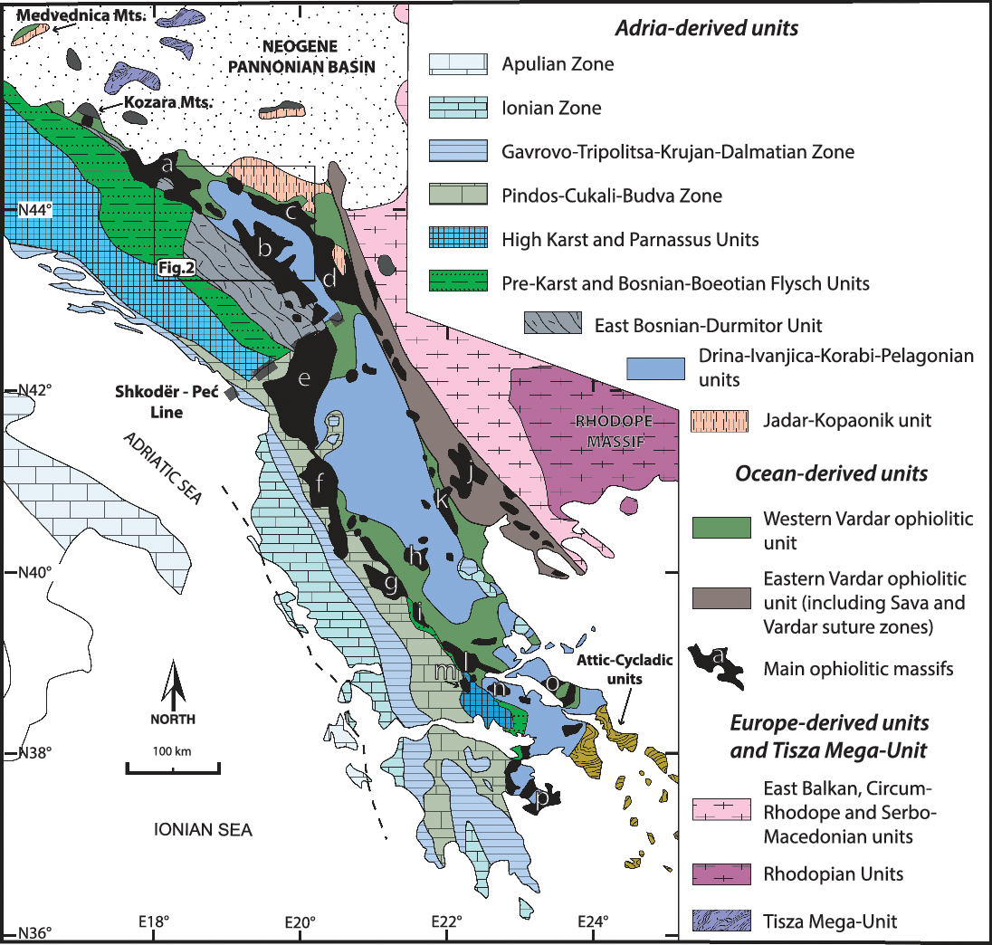
Ophiolite massifs in the Central Dinarides represent dismembered portions of a large ophiolite thrust sheet, associated with an underlying tectono-sedimentary mélange, that was obducted onto the eastern margin of the Adriatic Plate at the Jurassic–Cretaceous transition (Bernoulli & Laubscher, Reference Bernoulli and Laubscher1972; Schmid et al. Reference Schmid, Bernoulli, Fügenschuh, Matenco, Schefer, Schuster, Tischler and Ustaszewski2008; Chiari et al. Reference Chiari, Djerić, Garfagnoli, Hrvatović, Krstić, Levi, Malasoma, Marroni, Menna, Nirta, Pandolfi, Principi, Saccani, Stojadinović and Trivić2011; Ferrière et al. Reference Ferrière, Chanier and Ditbanjong2012; Nirta et al. Reference Nirta, Moratti, Piccardi, Montanari, Carras, Catanzariti, Chiari and Marcucci2018). Today, these ophiolite massifs are arranged along two subparallel, meridian-trending belts extending from Greece to the Pannonian Basin: the Eastern Vardar ophiolites (i.e. the ophiolites tectonically emplaced eastward above parts of the European margin) and the Western Vardar ophiolites (i.e. the ophiolites obducted westward above the Adria margin; Schmid et al. Reference Schmid, Bernoulli, Fügenschuh, Matenco, Schefer, Schuster, Tischler and Ustaszewski2008). In the Dinarides the two belts are separated by the Sava suture zone (Ustaszewski et al. Reference Ustaszewski, Kounov, Schmid, Schaltegger, Krenn, Frank and Fügenschuh2010), whereas to the south the limit mostly coincides with an intervening continental mega-unit known as the Pelagonian in Greece and Korabi in Albania (Fig. 1). In Serbia the Pelagonian–Korabi continental unit continues in the Drina–Ivanjica Unit. A long-standing and unsolved dispute exists among authors who consider the Pelagonian–Korabi–Drina–Ivanjica Mega-Unit as a microcontinent separating, during the Mesozoic period, two distinct oceanic basins (the Pindos ‘Ocean’ to the west and the Maliac–Vardar Ocean to the east: Robertson & Karamata, Reference Robertson and Karamata1994; Karamata et al. Reference Karamata, Olujić, Protić, Milovanović, Vujnović, Popević, Memović, Radovanović, Resimić-Sarić, Karamata and Janković2000; Robertson & Shallo, Reference Robertson and Shallo2000; Dimitrijević, Reference Dimitrijević2001; Stampfli & Borel, Reference Stampfli, Borel, Cavazza, Roure, Spakman, Stampfli and Ziegler2004) and those who regard this mega-unit as the easternmost rim of the Adriatic Plate located to the east of a unique oceanic basin (i.e. the Maliac–Vardar Ocean: Ferrière, Reference Ferrière1982; Pamić et al. Reference Pamić, Gušić and Jelaska1998; Bortolotti et al. Reference Bortolotti, Marroni, Pandolfi, Principi, Dilek, Ogawa, Bortolotti and Spadea2005; Schmid et al. Reference Schmid, Bernoulli, Fügenschuh, Matenco, Schefer, Schuster, Tischler and Ustaszewski2008, Reference Schmid, Fügenschuh, Kounov, Maţenco, Nievergelt, Oberhänsli, Pleuger, Schefer, Schuster, Tomljenović, Ustaszewski and van Hinsbergend2020; Chiari et al. Reference Chiari, Djerić, Garfagnoli, Hrvatović, Krstić, Levi, Malasoma, Marroni, Menna, Nirta, Pandolfi, Principi, Saccani, Stojadinović and Trivić2011; Gawlick et al. Reference Gawlick, Missoni, Suzuki, Lein, Sudar and Jovanović2016).
Tectonic sketch map of the Dinaric–Hellenic orogenic belt with simplified tectonic subdivision (modified after Schmid et al. Reference Schmid, Bernoulli, Fügenschuh, Matenco, Schefer, Schuster, Tischler and Ustaszewski2008) and distribution of the main ophiolitic massifs (in solid black). a – Krivaja–Konjuh; b – Zlatibor; c – Maljen; d – Ibar; e – Mirdita; f – South Albania; g – Pindos; h – Vourinos; i – Koziakas; j – Guevgueli; k – Almopias; l – Othrys; m – Iti; n – Kallidromon; o – Euboea; p – Argolis.

Here, we adopt a geotectonic scheme that considers the ophiolite massifs presently preserved in the Central Dinarides as pertaining to a single oceanic basin (Chiari et al. Reference Chiari, Djerić, Garfagnoli, Hrvatović, Krstić, Levi, Malasoma, Marroni, Menna, Nirta, Pandolfi, Principi, Saccani, Stojadinović and Trivić2011; Cvetković et al. Reference Cvetković, Prelević, Schmid and Papić2016; Gawlick et al. Reference Gawlick, Sudar, Missoni, Suzuki, Lein and Jovanović2017b; Schmid et al. Reference Schmid, Fügenschuh, Kounov, Maţenco, Nievergelt, Oberhänsli, Pleuger, Schefer, Schuster, Tomljenović, Ustaszewski and van Hinsbergend2020). From west to east the tectonic units are arranged as the Deformed Adriatic Zone (including the Budva–Cukali Zone, the Dalmatian Zone and the High Karst, Pre-karst and East Bosnian–Durmitor units; Aubouin et al. Reference Aubouin, Blanchet, Cadet, Celet, Charvet, Chorowicz, Cousin and Rampnoux1970; Schmid et al. Reference Schmid, Bernoulli, Fügenschuh, Matenco, Schefer, Schuster, Tischler and Ustaszewski2008), the Western Vardar ophiolitic unit (WVO; Dinaric Ophiolite Belt of Pamić et al. Reference Pamić, Tomljenović and Balen2002 and Chiari et al. Reference Chiari, Djerić, Garfagnoli, Hrvatović, Krstić, Levi, Malasoma, Marroni, Menna, Nirta, Pandolfi, Principi, Saccani, Stojadinović and Trivić2011), the continental-derived Drina–Ivanjica Unit, the Eastern Vardar ophiolitic unit (EVO; Vardar Ophiolite Belt of Chiari et al. Reference Chiari, Djerić, Garfagnoli, Hrvatović, Krstić, Levi, Malasoma, Marroni, Menna, Nirta, Pandolfi, Principi, Saccani, Stojadinović and Trivić2011), and the Serbo-Macedonian–Rhodope Massif, generally considered to be the metamorphosed and deformed margin of the Eurasian Plate (Burg, Reference Burg, Skourtsos and Lister2012; Bonev et al. Reference Bonev, Marchev, Moritz and Collings2015; Fig. 1). The East Bosnian–Durmitor and Drina–Ivanjica units share a very similar stratigraphic succession including a pre-Carboniferous basement unconformably overlain by upper Palaeozoic deposits, Triassic siliciclastic rocks and carbonates, Upper Triassic – Lower Jurassic platform carbonates and finally by Lower–Upper Jurassic deep-water carbonates and radiolarites (Dimitrijević, Reference Dimitrijević1997; Karamata, Reference Karamata, Robertson and Mountrakis2006; Djerić et al. Reference Djerić, Gerzina and Schmid2007; Chiari et al. Reference Chiari, Djerić, Garfagnoli, Hrvatović, Krstić, Levi, Malasoma, Marroni, Menna, Nirta, Pandolfi, Principi, Saccani, Stojadinović and Trivić2011). These similarities and their common structural position below the WVO are in accordance with a common palaeogeographic position on the easternmost tip of the Adriatic continental margin. In western Serbia, the ophiolitic massifs of the WVO (mainly represented by the Zlatibor and the Maljen massifs) have exactly the same geological features and therefore are considered to have had physical continuity, which was disrupted during exhumation of the Drina–Ivanjica Unit (Chiari et al. Reference Chiari, Djerić, Garfagnoli, Hrvatović, Krstić, Levi, Malasoma, Marroni, Menna, Nirta, Pandolfi, Principi, Saccani, Stojadinović and Trivić2011; Porkolab et al. Reference Porkolab, Köver, Benko, Heja, Fialowski, Soos, Gerzina Spajić, Đerić and Fodor2019). Finally, the more internal Adria-derived unit is represented by the Jadar–Kopaonik Unit, consisting of a Palaeozoic metasedimentary succession overlain by a Middle Permian to Lower–Middle Triassic shallow-water clastic–carbonate sedimentary succession (Robertson et al. Reference Robertson, Karamata, Šarić, Robertson, Karamata and Šarić2009) passing into Middle Triassic to Jurassic hemipelagic and distal turbiditic carbonates and radiolarites (Schefer et al. Reference Schefer, Egli, Missoni, Bernoulli, Fügenschuh, Gawlick, Jovanović, Krystin, Lein, Schmid and Sudar2010b). These successions are considered to be part of the distal part of the Adria passive margin facing the northern branch of the Neotethys (Schefer et al. Reference Schefer, Egli, Missoni, Bernoulli, Fügenschuh, Gawlick, Jovanović, Krystin, Lein, Schmid and Sudar2010b; Gawlick et al. Reference Gawlick, Sudar, Missoni, Suzuki, Lein and Jovanović2017b).
The tectonic evolution in the internal (eastern) part of the Central Dinaric orogenic belt began in Middle Jurassic time and was marked by three major geodynamic events: (1) Middle Jurassic intraoceanic subduction that led to the formation of high temperature – low pressure (HT–LP) metamorphism in the hanging wall (amphibolite sole; Lanphere et al. Reference Lanphere, Coleman, Karamata and Pamić1975; Okrusch et al. Reference Okrusch, Seidel, Kreuzer and Harre1978; Dimo-Lahitte et al. Reference Dimo-Lahitte, Monié and Vergély2001; Borojević Šoštarić et al. Reference Borojević Šoštarić, Palinkaš, Neubauer, Cvetković, Bernroider and Genser2014); (2) Late Jurassic/Early Cretaceous obduction of the oceanic lithosphere onto the eastern Adriatic continental margin; and (3) Late Cretaceous–Palaeogene collision of the Eurasian Plate with the Adriatic Plate (Ustaszewski et al. Reference Ustaszewski, Kounov, Schmid, Schaltegger, Krenn, Frank and Fügenschuh2010). In the external part of the orogen, bauxite and lateritic horizons and widespread karst depressions, possibly related to uplift, emersion and erosion of portions of the Adria carbonate platform during latest Jurassic time, were the first indicators of plate convergence in the proximal continental domain (Carras & Tselepidis, Reference Carras, Tselepidis, Solakius and Kati2001; Vlahović et al. Reference Vlahović, Tišljar, Velić and Matičec2005).
2.b. Outline of the syn- and post-obduction depositional sequences in the Dinaric–Hellenic orogen
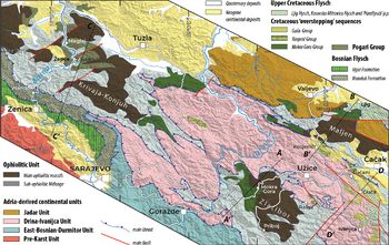
In the internal (eastern) part of the Dinaric–Hellenic orogenic system, the units deformed during the Late Jurassic – Early Cretaceous tectonic phase are unconformably overlain by the widespread Cretaceous transgression successions (Radoičić, Reference Radoičić1995; Photiades et al. Reference Photiades, Carras, Bortolotti, Fazzuoli and Principi2007; Fazzuoli et al. Reference Fazzuoli, Menna, Nirta, Carras and Principi2008). These sediments are known throughout the entire Dinaric–Hellenic orogen alternatively as ‘overstepping sediments’, ‘Gosau-type deposits’, ‘deposits of the Cretaceous transgression’, ‘post-obduction sedimentary cover’ and the ‘Mesoautochthonous Complex’ (Jacobshagen, Reference Jacobshagen1986; Willingshofer et al. Reference Willingshofer, Neubauer and Cloetingh1999; Hrvatović, Reference Hrvatović2006; Photiades et al. Reference Photiades, Carras, Bortolotti, Fazzuoli and Principi2007; Fazzuoli et al. Reference Fazzuoli, Menna, Nirta, Carras and Principi2008; Schmid et al. Reference Schmid, Bernoulli, Fügenschuh, Matenco, Schefer, Schuster, Tischler and Ustaszewski2008; Schuller et al. Reference Schuller, Frisch, Danisik, Dunkl and Melinte2009; Nirta et al. Reference Nirta, Moratti, Piccardi, Montanari, Carras, Catanzariti, Chiari and Marcucci2018). They are made up of terrestrial, transitional and shallow-marine coarse-grained clastic sedimentary rocks and of marine fine-grained clastic sediments and carbonates. The composition of the clastic deposits directly depends on the lithology of the underlying or adjacent substratum. These deposits presently crop out over areas of varying extension (Fig. 2), from several hundred kilometre wide continuous successions to small-scale slices occurring as tectonic chunks or olistoliths inside tectonic mélanges. These transgressive deposits form a roughly N–S-trending stripe in the internal (eastern) part of the orogen, extending from southern Greece (Argolis; Bortolotti et al. Reference Bortolotti, Carras, Chiari, Fazzuoli, Marcucci, Photiades and Principi2003) to at least southwestern Serbia (Bortolotti et al. Reference Bortolotti, Ficcarelli, Manetti, Passerini, Pirini-Radrizzani and Torre1971; Pejović & Radoičić, Reference Pejović and Radoičić1971; Sladic-Trifunovic, Reference Sladic-Trifunovic1998), through central and northern Greece (Carras et al. Reference Carras, Fazzuoli and Photiades2004; Photiades et al. Reference Photiades, Carras, Bortolotti, Fazzuoli and Principi2007), Albania (Gawlick et al. Reference Gawlick, Frisch, Hoxha, Dumitrica, Krystyn, Lein, Missoni and Schlagintweit2008) and North Macedonia. The bedrock of these deposits consists both of oceanic crust and continental margin units. The ophiolites show evidence of emergence with the formation of rather high reliefs that underwent erosion and pedogenesis (Photiades et al. Reference Photiades, Carras, Bortolotti, Fazzuoli and Principi2007; Fazzuoli et al. Reference Fazzuoli, Menna, Nirta, Carras and Principi2008). The basal portions of these successions, commonly clastic, are usually devoid of datable fossils, and biostratigraphic age determinations are only possible in the overlying marine deposits. The oldest fossiliferous deposits are generally Aptian to Cenomanian: Mokra Gora (Pejović & Radoičić, Reference Pejović and Radoičić1971); Mirdita, northern Albania (Schlagintweit et al. Reference Schlagintweit, Gawlick, Lein, Missoni and Hoxha2012); Argolis Peninsula, Greece (Bortolotti et al. Reference Bortolotti, Carras, Chiari, Fazzuoli, Marcucci, Photiades and Principi2003); and Vourinos and Vermion massifs, Greece (Carras et al. Reference Carras, Fazzuoli and Photiades2004; Photiades et al. Reference Photiades, Carras, Bortolotti, Fazzuoli and Principi2007).
Simplified tectonic map of western Serbia and eastern Bosnia (location in Fig. 1). Redrawn after the Geological Map of Yugoslavia at scale 1:500.000 (Federal Geological Survey of SRF Yugoslavia, 1970), Schmid et al. (Reference Schmid, Bernoulli, Fügenschuh, Matenco, Schefer, Schuster, Tischler and Ustaszewski2008) and Chiari et al. (Reference Chiari, Djerić, Garfagnoli, Hrvatović, Krstić, Levi, Malasoma, Marroni, Menna, Nirta, Pandolfi, Principi, Saccani, Stojadinović and Trivić2011).

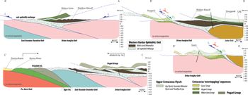
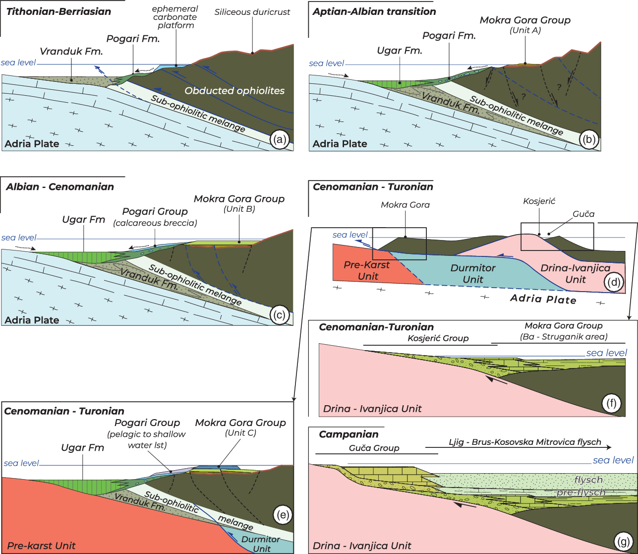
Owing to the nature of their bedrock, stratigraphic age and geological characteristics, the post-orogenic Cretaceous deposits cropping out in the Zlatibor–Malijen areas (western Serbia) were assigned by Chiari et al. (Reference Chiari, Djerić, Garfagnoli, Hrvatović, Krstić, Levi, Malasoma, Marroni, Menna, Nirta, Pandolfi, Principi, Saccani, Stojadinović and Trivić2011) to three main informal groups: the Mokra Gora Group (the type section of which is described here); Kosjerić Group (Cenomanian–Turonian, Radoičić & Schlagintweit, Reference Radoičić and Schlagintweit2007); and Guča Group (Campanian, Radoičić et al. Reference Radoičić, Radulović, Rabrenović and Radulović2010; Chiari et al. Reference Chiari, Djerić, Garfagnoli, Hrvatović, Krstić, Levi, Malasoma, Marroni, Menna, Nirta, Pandolfi, Principi, Saccani, Stojadinović and Trivić2011). The Mokra Gora Group is lying on top of the ophiolites, the Kosjerić Group is overlying both ocean-derived and continental-derived rocks, and the Guča Group exclusively covers continental units (i.e. the Drina–Ivanjica Unit) (Fig. 3).
Schematic geological cross-sections showing relationships between the Cretaceous deposits and their substratum. The geographic locations of the cross-sections are indicated in Figure 2. Age of the tectonic activity along the main structural features: J3 – Late Jurassic; Cr2 – Late Cretaceous; P – Palaeogene.

Older sedimentary successions are reported to stratigraphically rest above the ophiolite along the Dinaric–Hellenic chain. In the Žepče–Zavidovići–Maglaj area (Bosnia and Herzegovina; Fig. 2), the ophiolites are covered by a coarse-grained flysch succession containing shallow-water limestone clasts and blocks with a Tithonian–Berriasian fauna and ophiolite- and continent-derived clasts including Upper Permian granite, which passes upwards into a succession consisting of bioclastic limestones, calcareous breccia and pelagic limestones of early Albian to late Santonian age (Jovanović, Reference Jovanović1961; Blanchet et al. Reference Blanchet, Durand Delga, Moullade and Sigal1970; Hrvatović, Reference Hrvatović2006). These deposits, known in the literature as the ‘Pogari Series’ (Jovanović, Reference Jovanović1961), ‘Série de Maglaj’ (Blanchet et al. Reference Blanchet, Durand Delga, Moullade and Sigal1970) or ‘Pogari Formation’ (Hrvatović, Reference Hrvatović2006), are here renamed as the ‘Pogari Group’ in order to account for their complex lithostratigraphic, chronostratigraphic and environmental evolution. A similar stratigraphic position characterizes the Tithonian–upper Valanginian deposits of the ophiolite-bearing Firza flysch exposed in northern Albania (Gardin et al. Reference Gardin, Kici, Marroni, Mustafa, Pandolfi, Pirdini and Xhomo1996) containing a lower member characterized by abundant platform carbonate clasts of ?Kimmeridgian–Tithonian age (Kurbnesh Formation of Schlagintweit et al. Reference Schlagintweit, Gawlick, Missoni, Hoxha, Lein and Frisch2008). The Firza flysch and adjacent ophiolites and mélange were later unconformably covered by upper Berriasian–Valanginian Munella platform carbonates (Gawlick et al. Reference Gawlick, Frisch, Hoxha, Dumitrica, Krystyn, Lein, Missoni and Schlagintweit2008), probably deposited above the obducting ophiolites, and were then deformed and partly dismantled during the last stages of obduction tectonics (Peza & Marku, Reference Peza and Marku2002; Schlagintweit et al. Reference Schlagintweit, Gawlick, Lein, Missoni and Hoxha2012). Finally, the Firza flysch and Munella carbonates were unconformably covered by shallow-water limestones starting in early Aptian time (Mali i Shenjtit Platform; Schlagintweit et al. Reference Schlagintweit, Gawlick, Lein, Missoni and Hoxha2012).
As terrestrial to shallow-marine sedimentation resumed above the ophiolites, turbiditic deposition took place in front of the ophiolite thrust sheet in the pro-wedge flexural basins formed as a consequence of the nappe stacking following the ophiolite obduction. The older flysch deposits on the flexured continental margin are Tithonian–Berriasian in age and are discontinuously exposed along the whole Dinaric–Hellenic chain. They are named the Boeotian flysch in Greece (Clément, Reference Clément1971; Nirta et al. Reference Nirta, Moratti, Piccardi, Montanari, Catanzariti, Carras and Papini2015), whereas in the Central Dinarides they are known as the Bosnian flysch (Blanchet, Reference Blanchet1966). The latter crops out along a NW–SE-aligned thrust sheet known as the Pre-karst Unit (Schmid et al. Reference Schmid, Bernoulli, Fügenschuh, Matenco, Schefer, Schuster, Tischler and Ustaszewski2008 with references) that is lying below the East Bosnian–Durmitor Unit, which in turn is overlain by the Western Vardar ophiolites (Charvet, Reference Charvet1978). The Bosnian flysch consists of a lower lithostratigraphic unit, mostly reported as Tithonian to Valanginian (Blanchet, Reference Blanchet1966, Reference Blanchet1968; Charvet, Reference Charvet1967; Cadet, Reference Cadet1968; Rampnoux, Reference Rampnoux1969) and up to Aptian in age (Cadet & Sigal, Reference Cadet and Sigal1969; Charvet, Reference Charvet1978; Mikes et al. Reference Mikes, Christ, Petri, Dunkl, Frei, Baldi-Beke, Reitner, Wemmer, Hrvatović and von Eynatten2008), that is mainly composed of siliciclastic deposits (Vranduk Formation) followed upwards by lower Albian to Maastrichtian carbonate-dominated clastic deposits of the Ugar Formation (Mikes et al. Reference Mikes, Christ, Petri, Dunkl, Frei, Baldi-Beke, Reitner, Wemmer, Hrvatović and von Eynatten2008 with references). According to Mikes et al. (Reference Mikes, Christ, Petri, Dunkl, Frei, Baldi-Beke, Reitner, Wemmer, Hrvatović and von Eynatten2008), the upper part of the Vranduk Fm is at least Aptian in age. According to several authors (Dimitrijević, Reference Dimitrijević1982; Csontos et al. Reference Csontos, Gerzina, Hrvatović, Schmid and Tomljenović2003; Schmid et al. Reference Schmid, Bernoulli, Fügenschuh, Matenco, Schefer, Schuster, Tischler and Ustaszewski2008), sedimentation of the Ugar Fm started upon the deformed Vranduk Fm above an unconformity surface, suggesting deformation and involvement of the Vranduk Fm in the advancing thrust stack before early Albian time.
Provenance studies of the Vranduk Fm suggest sediment feeding from the obducted ophiolites, granitoids, eroding continental areas, reefs and different environments in a Urgonian-type carbonate platform facies, which existed only since late Barremian time (Mikes et al. Reference Mikes, Christ, Petri, Dunkl, Frei, Baldi-Beke, Reitner, Wemmer, Hrvatović and von Eynatten2008). A similar provenance configuration characterizes the basal clastic succession of the Pogari Group (Blanchet et al. Reference Blanchet, Durand Delga, Moullade and Sigal1970), whereas a clearly different shedding scenario marks the transition to the Upper Cretaceous Ugar Fm, with increasing detrital inputs from carbonate rocks and a drastic decrease of siliciclastic material, in particular Cr-spinel grains (Mikes et al. Reference Mikes, Christ, Petri, Dunkl, Frei, Baldi-Beke, Reitner, Wemmer, Hrvatović and von Eynatten2008). The occurrence of abundant quartz and metamorphic lithic fragments inside the Vranduk Fm suggests the existence of an Early Cretaceous source area where continental basement was exposed. Zircon fission track (ZFT) analyses of the siliciclastic detritus from the Vranduk Fm provide evidence of an Aptian cooling age (averaging 120 Ma) for the source area (Mikes et al. Reference Mikes, Christ, Petri, Dunkl, Frei, Baldi-Beke, Reitner, Wemmer, Hrvatović and von Eynatten2008), which points to the presence of exhumed portions of continental margin units of the Adriatic Plate soon after the end of the obduction tectonic processes. This age compares well with similar cooling ages from Lower Cretaceous foredeep deposits in the Zagreb region (122 ± 45 ZFT age from the Aptian–Albian Bistra Formation; Lužar-Oberiter et al. Reference Lužar-Oberiter, Mikes, Dunkl, Babić and Eynatten2012) and from a low-grade metamorphic unit of the Drina–Ivanjica Unit (139–129 Ma K–Ar age, Milovanović, Reference Milovanović1984). For this latter unit, an early phase of deformation (Tithonian–Valanginian; 150–135 Ma K–Ar age), coeval with the W-directed obduction event, was reported by Porkolab et al. (Reference Porkolab, Köver, Benko, Heja, Fialowski, Soos, Gerzina Spajić, Đerić and Fodor2019). Moreover, the continental clastic deposits of pre-Cenomanian age resting unconformably on the Drina–Ivanjica Palaeozoic rocks contain abundant lithoclasts of Triassic and Jurassic carbonate as well as quartz and metamorphic rock fragments (Kosjerić Group of Chiari et al. Reference Chiari, Djerić, Garfagnoli, Hrvatović, Krstić, Levi, Malasoma, Marroni, Menna, Nirta, Pandolfi, Principi, Saccani, Stojadinović and Trivić2011). This strongly suggests that the Mesozoic cover of the internal sectors of the imbricated Adriatic margin was tectonically removed and the Palaeozoic basement exhumed and exposed to subaerial erosion during Early Cretaceous time.
Here the sedimentary evolution of the Mokra Gora Group has been analysed in detail in its type area in the Zlatibor Massif and in key outcrops located on the Maljen massif. Supplementary investigations have also been performed in key sections pertaining to the Kosjerić and Guča groups. The results were then compared with the sedimentary evolution of partly coeval shallow-water to pelagic deposits (Pogari Group and Bosnian flysch) and with the evolution of the AdCP.
3. Field data
3.a. Mokra Gora Group in the Zlatibor and Maljen ophiolitic massifs
A detailed reconstruction of the Mokra Gora Group succession was possible only for the deposits exposed above the Zlatibor ophiolites, while a schematic lithostratigraphic reconstruction was done in the scattered outcrops located above the Maljen ophiolites.
Several authors have studied the Mokra Gora succession in the Zlatibor Mountains, identifying lithostratigraphic units that sometimes refer to non-synchronous and incomparable sedimentary packages (Loczy, Reference Loczy1924; Milovanović, Reference Milovanović1933; Drakulić & Dedić, Reference Drakulić and Dedić1963; Fotić, Reference Fotić1962). Generally, three main lithostratigraphic units have been differentiated: (1) a basal clastic unit unconformably lying on weathered serpentinite; (2) an intermediate hemipelagic marly limestone unit; and (3) an upper shallow-water massive reef limestone unit with an abundant rudist fauna (Radoičič, Reference Radoičić1984).
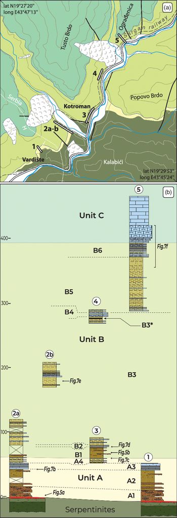
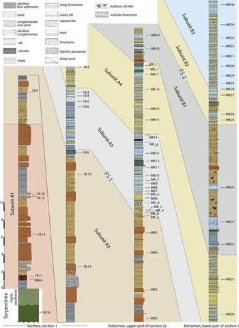
The lithostratigraphic column of the Mokra Gora Group in the Zlatibor area is a composite and results from four partial stratigraphic sections measured and sampled in the valley of the Kamišna creek, a tributary of the Beli Rzav River, near the border with Bosnia and Herzegovina (Mokra Gora area). Supplementary observations on the lowermost part of the succession were made in the close-by village of Vardište (Bosnia and Herzegovina) (Fig. 4a). The Mokra Gora sedimentary succession is weakly affected by tectonic deformation that is mainly represented by large open folds and interstratal slip. A kilometre-sized open fold trending WSW–ENE and gently plunging to the WSW represents the main tectonic structure.
(a) Geological map of the Kotroman–Vardište area (~5 km southwest of Mokra Gora village) with location of the studied stratigraphic sections. (b) Sketch of the measured sections within the Mokra Gora Group.

The lithostratigraphic column was reconstructed through the recognition of key strata and intervals. The lithological and sedimentological features of the Mokra Gora succession reflect two deepening–shallowing cycles, named Unit A and Unit B, topped by shallow-marine rudist-bearing carbonates (Unit C). A detailed study was performed in the A and B units while the C unit was not studied. The measured thickness of units A and B is more than 400 m (Fig. 4).
The lower portion of the succession was measured at Vardište, a little village north of the railway station (section 1; 43° 45′ 40.0″ N 19° 27′ 29.1″ E – same outcrops studied by Bortolotti et al. Reference Bortolotti, Ficcarelli, Manetti, Passerini, Pirini-Radrizzani and Torre1971) and in the vicinity of Kotroman village (section 2: 43° 46′ 01.0″ N 19° 28′ 07.2″ E; section 3: 43° 46′ 05.0″ N 19° 28′ 22.4″ E); the middle and upper portions of the succession were studied on the eastern flank of Tusto Brdo (section 4: 43° 46′ 37.1″ N 19° 28′ 36.2″ E) and on the southern slope of Ograđenica Hill (section 5: 43° 46′ 59.9″ N 19° 28′ 54.5″ E) and south of Kotroman village (section 2b: 43° 46′ 06.6″ N 19° 27′ 54.6″ E) (Fig. 4). Previous detailed lithostratigraphic studies were performed only on the Vardište section by Bortolotti et al. (Reference Bortolotti, Ficcarelli, Manetti, Passerini, Pirini-Radrizzani and Torre1971). Other studies focused on a general description of the main lithostratigraphic units and their respective biostratigraphic assemblages and gave no precise stratigraphic location for the samples collected and studied (Pejović & Radoičić, Reference Pejović and Radoičić1971; Banjac et al. Reference Banjac, Bandel and Kiel2007, Reference Banjac, Jovanović, Dulić and Ljubović-Obradović2008; Radoičić & Schlagintweit, Reference Radoičić and Schlagintweit2007). As a consequence, in some cases it was impossible to make a reliable correlation of the biostratigraphic data, especially in the lower portion of the succession, as previous workers recognized the presence of only one deepening–shallowing cycle. The majority of workers studied single outcrops located north of Kotroman (section 3; Banjac et al. Reference Banjac, Bandel and Kiel2007) and north of Mokra Gora village (Pejović & Radoičić, Reference Pejović and Radoičić1971; Radoičić & Schlagintweit, Reference Radoičić and Schlagintweit2007), which are representative of Unit B only.
3.a.1. Basement
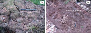
The basement of the Mokra Gora succession is represented by serpentinites belonging to the Zlatibor ophiolitic massif. The topmost portion of the serpentinites is fractured and strongly weathered and shows a reddish colour from diffuse iron oxides. The serpentinites are topped by a discontinuous level of laterite and then by a decimetre-thick horizon of siliceous duricrust (silcrete). This is a massive quartz-rich layer with diffuse Fe-oxides that homogeneously covers the weathering profiles on the top of the serpentinites. The upper surface of the silcrete horizon has a globular appearance suggesting that the silcrete is originated from the coalescence of several bulbous silcrete masses (Fig. 5). At the microscopic scale, the silcrete consists of amorphous silica particles cementing sub-millimetric to centimetric clasts of deeply weathered minerals coming from the underlying serpentinite basement (Bortolotti et al. Reference Bortolotti, Ficcarelli, Manetti, Passerini, Pirini-Radrizzani and Torre1971). The main feature of the weathered horizon and the association with silcrete and laterite suggests the prolonged exposure of the serpentinites to a subaerial environment in a warm and humid climatic regime (Summerfield, Reference Summerfield1983).
(a) Silcrete horizon lying above the weathered serpentinite (Kotroman area, base of section 2a in Fig. 4). Pen for scale is ~14 cm long. (b) Bulbous silcrete occurrences within the shale and silty layers of subunit B1 (Kotroman area, see Figs 4 and 6 for location). Hammer for scale is 33 cm long.

3.a.2. Unit A
The stratigraphic section was measured and sampled along the Šargan Eight Railway on the right side of the Šarganišica Creek. Additional observations were made in the Vardište area. The total thickness of the unit is ~60 m. Based on lithological differences, Unit A was subdivided into four subunits (subunits A1, A2, A3 and A4).
3.a.2.a. Subunit A1
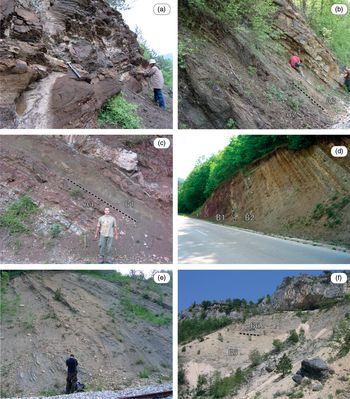
This subunit is made up of metre-thick conglomerates alternating with subordinate coarse- to fine-grained litharenitic (mostly ophiolite-derived clasts) sandstones and siltstones (Figs 6, 7a). The conglomeratic horizons are sometimes channelized and show crude clast imbrication. The silty horizons are laterally continuous at the outcrop scale and are massive or characterized by plane-parallel laminations. The sandy levels are characterized by cross-stratification; they are discontinuous and sometimes show pinch-out terminations. All the deposits of this subunit are dark red in colour. Clasts from the conglomerates, consisting mostly of serpentinites with a few basalts and cherts, exhibit a provenance from the ophiolitic substratum. Their size varies from 2 cm to 20 cm, they are well rounded to sub-rounded and they are often silicified and/or replaced by limonite alteration. The replacement of the host sediments by silica is so strong that, in some cases, it leads to the formation of layers of decimetre-thick silcrete. Laterite deposits consisting of poorly sorted litharenites with a ferruginous matrix are present in decimetre-thick pockets in the lower portion of the subunit, sometimes hosting concentrations of spherules of Fe–Ni oxides (oolitic iron; Fotić, Reference Fotić1962). Widespread Fe-oxides give this subunit a dark red colour. The thickness of subunit A1, as measured in the Vardište section, is ~20 m (section 1, Figs 4, 6). The transition to subunit A2 is marked by the disappearance of the conglomeratic levels. Overall, the subunit is arranged in a fining-upward and thinning-upward succession.
Lithostratigraphic composite column of the lower part of the Mokra Gora Group in the type area. See Figure 4 for locations. FS – flooding surface.

Key outcrop photographs of the Mokra Gora Group. (a) Basal conglomerates and sandstones of subunit A1; Vardište area 43° 43′ 56″ N; 19° 27′ 53″ E. (b) Transition between subunits A2 and A3 along stratigraphic column 2a; see Figure 4 for location. (c, d) Transitions between units A and B and between subunits B1 and B2, respectively, Užice–Višegrad road-cut near Kotroman village (lithostratigraphic column 3 in Fig. 4). (e) Marlstone and limestone succession characterizing subunit B3 (lithostratigraphic column 2b in Fig. 4). (f) Uppermost portion of Unit B and contact with massive limestones of Unit C, Ograđenica Hill (lithostratigraphic column 5 in Fig. 4).

The lithofacies association of subunit A1 can be related to a high-energy fluvial environment, probably with braided channels, in a warm and humid climate.
3.a.2.b. Subunit A2
Subunit A2 consists of massive decimetre-thick to metre-thick beds of ophiolitic sandstones and siltstones alternating with centimetre- to decimetre-thick massive shales. The coarse-grained sandstones show a faint cross-lamination. Microconglomeratic centimetre-thick lenticular pockets are scattered in the siltstone levels. Rare decimetre-thick silcrete horizons are also present. Rock fragments are angular and contain alterations of minerals, mainly chlorite, relics of olivine and pyroxene and opaque heavy minerals (magnetite, spinel, etc.) floating in a haematitic–goethitic detrital matrix. Sub-spherical ferruginous nodules, probably derived from laterite crusts, are also present and in some cases are surrounded by a thin film of authigenic quartz. In the uppermost half-metre of the subunit a lithic–carbonatic sandstone occurs with scattered recrystallized bioclasts and mixed micritic/detrital matrix. The thickness of this subunit measured in the Vardište and Kotroman sections is nearly 25 m (sections 1 and 2a, Figs 4, 6).
This subunit depicts a fining-upward and thinning-upward succession. It is interpreted to have originated from fluvial environments, probably meandering streams, in a warm and humid climate.
3.a.2.c. Subunit A3
The shift from subunit A2 to A3 is marked by the appearance of the first marly layer (Fig. 7b). The lower portion of subunit A3 is represented by marlstones alternating with centimetre- and decimetre-thick beds of nodular bioclastic limestones (mudstones, wackestones and packstones) and a few centimetre-thick red-coloured ophiolite-bearing sandstones. Bioturbation is common. The nodular limestones probably derive from the interference between bioturbation and differential dissolution/cementation, as suggested by the occurrence of dissolution seams made up of clay minerals and opaque oxides.
In an upward direction the ophiolite-derived fragments progressively decrease and the succession is characterized by well-bedded decimetre-thick (max. 50 cm) bioclastic mudstones to packstones, and locally rudstones/floatstones, regularly alternating with marlstones and siltstones. Accumulations of bivalves and gastropods are scattered in the subunit. The thickness of this subunit measured in the Kotroman sections is 10 m (section 2a, Fig. 6).
The bioclastic wackestones and mudstones suggest lagoonal and marine subtidal environments of the inner ramp (sensu Burchette & Wright, Reference Burchette and Wright1992). The bioclastic floatstones and rudstones were likely deposited during storm events (tempestites).
3.a.2.d. Subunit A4
The transition from subunit A3 to A4 is marked by an abrupt decrease in thickness and frequency of the decimetre-thick limestone beds and an increase in the marly portion. Subunit A4 consists of decimetre-thick beds of fossiliferous marlstones regularly alternating with centimetre- to decimetre-thick beds of nodular bioclastic packstones/floatstones passing upwards to decimetre-thick beds of packstones and, finally, to decimetre-thick coarse- to fine-grained ophiolite-bearing sandstones. Reworked layers of bioclastic packstones/rudstones with variable amounts of ophiolite-derived clasts are common in the upper portion of the subunit. Generally, the high amount of the clastic input is marked by a dark red colouring. Fenestral porosity, associated with organic decay and other syn-sedimentary processes, is locally common. The subunit represents a coarsening- and thickening-upward succession. The transition to Unit B happens through the progressive increase of terrigenous layers and the decrease of carbonates until their complete disappearance. The thickness of this subunit measured in the Kotroman sections is 8 m (section 2a, Fig. 6).
Subunit A4 was deposited in a mixed carbonate–clastic inner-ramp environment. The progressive upward increase of extrabasinal rock fragments and storm beds indicates a shallowing-upward trend.
3.a.3. Unit B
Unit B is widely exposed throughout the Mokra Gora area with a total thickness of ~335 m. The main lithological features allow the distinguishing of six subunits (subunits B1, B2, B3, B4, B5 and B6).
3.a.3.a. Subunit B1
The basal portion of subunit B1 is characterized by the occurrence of a 2 m thick reddish siltstone including a caliche horizon overlain by a metre-thick level of dark red siltstones with diffuse bulbous silcrete masses and rare decimetre-thick caliche horizons rich in Fe-oxides (Fig. 7c). Over the basal siltstone layer, some centimetre- to decimetre-thick lenses of medium- to coarse-grained ophiolitic sandstones are dispersed in a siltstone matrix overall arranged as a thinning- and fining-upward succession. The thickness of this subunit measured in the Kotroman sections is 15 m (section 3, Fig. 6).
The base of subunit B1 represents a type 1 sequence boundary separating a shallow-marine facies from sediments deposited in a coastal plain/restricted lagoon and characterized by pedogenesis with caliche and silcrete formation in an arid climate.
3.a.3.b. Subunit B2
The subunit consists of centimetre- to decimetre-thick beds of nodular fossiliferous wackestones to packstones alternating with marlstones (Fig. 7d). The middle part of the subunit is characterized by a 1.5–2 m thick interval consisting of decimetre-thick red siltstones alternating with centimetre-thick mixed carbonate–ophiolitic coarse-grained reddish sandstones. The thickness of this subunit measured in the Kotroman sections is nearly 5 m (section 3, Fig. 6).
Deposition took place in a partially restricted lagoon with occasional terrigenous inflow. The sudden increase in the water depth from subunit B1 to B2 indicates the second flooding surface recognizable in the Mokra Gora succession (Fig. 6).
3.a.3.c. Subunit B3
Subunit B3 consists of a regular alternation of centimetre- to decimetre-thick beds of bioclastic marlstones, marly bioclastic packstones and bioclastic wackestones, which are sometimes nodular (Fig. 7e). In the upper part of subunit B3 a 5 m thick interval of thin-bedded to laminated dark marls rich in organic matter occurs, alternating with marly bioclastic wackestones (B3* level in Fig. 4b). Bivalves and gastropods are present in the marly levels, whereas centimetre-thick shell accumulations (storm layers) frequently occur in the limestone beds. The lithological association pertaining to this subunit is the best-developed one in the studied succession with a total thickness of ~200 m (Kotroman sections 2, 2b and 3, Figs 4, 6).
The subunit represents a deepening-upward trend associated with an inner- to mid-ramp environment characterized by frequent storm events. The dark grey bituminous level (B3*) testifies to an anoxic episode and possibly a maximum flooding surface.
3.a.3.d. Subunit B4
This subunit is ~15 m thick and is intercalated in the upper part of subunit B3 just above the bituminous event B3* (section 4, Fig. 4). It consists of decimetre- to metre-thick marly limestones (bioclastic packstones/wackestones) and calcarenites irregularly interbedded with centimetre-thick marlstones. The calcarenite beds were most likely deposited by turbidite currents (Bouma intervals Ta-b) and are locally associated with decimetre-thick slumped layers.
This subunit represents an episode of resedimentation events, both by turbidity currents and slumping. The abrupt occurrence and its stratigraphic position between deeper-water deposits may suggest a tectonic phase, possibly compressive, heralding the return to shallow-water conditions and the following onset of rudist reefs.
3.a.3.e. Subunit B5
The B5 lithological association is very similar to that of subunit B3 (Fig. 7f). Nevertheless, the two subunits were separated by using different acronyms to avoid confusion. It has a thickness of ~70 m and, similar to subunit B3, it consists of regular alternations of centimetre- to decimetre-thick beds of bioclastic marlstones, marly bioclastic packstones and bioclastic wackestones, which are sometimes nodular. Centimetre-thick shell accumulations (storm layers) frequently occur in the marly levels.
The deposition of this subunit occurred mostly in a mid-ramp environment characterized by frequent storm events.
3.a.3.f. Subunit B6
The top of Unit B is represented by an ~30 m thick succession of centimetre- to decimetre-thick bioclastic packstones/wackestones, which are locally nodular, and calcarenites irregularly interbedded with centimetre-thick marlstones (section 5, Figs. 4, 7f). The transition with the underlying subunit B5 is gradual, whereas the contact with the massive limestones of Unit C is sharp and locally tectonized.
The lithological association of this subunit represents the return to subtidal inner-ramp environments. The thickening- and coarsening-upward organization of beds, their syn-sedimentary deformation and the abundant fragments of shallow-water organisms (rudists and other molluscs; halimedacean algae) within deeper-water marly sediments indicates the progradation of ramp deposits in front of a shallow-water reef system.
3.a.4. Unit C
Unit C consists of massive to metre-thick bedded rudist lithosomes and bioclastic deposits. The exposure of the basal contact in Ograđenica Hill shows evidence of a slight angular unconformity at the contact with Unit B (Fig. 7f). The exposed thickness of this unit is ~70 m and could be subdivided into a lower part made up of massive limestones (~20 m thick) and an upper part of well-bedded limestones (~50 m thick).
This unit was deposited in a shallow-water environment. Olujić et al. (Reference Olujić, Pamić and Kapeler1987) reported, albeit poorly constrained, another transition to basinal environments in post-Santonian time.
Another significant succession pertaining to the Mokra Gora Group crops out in a more internal position on top of the ophiolites of the Maljen massif between Struganik and Ba villages (Figs 2, 3; see geological map in Chiari et al. Reference Chiari, Djerić, Garfagnoli, Hrvatović, Krstić, Levi, Malasoma, Marroni, Menna, Nirta, Pandolfi, Principi, Saccani, Stojadinović and Trivić2011). In this succession only one transgressive cycle is recognized, and the deepening-upward trend is constant from Cenomanian to early Campanian times.
The succession here starts with ophiolite-bearing conglomerates and sandstones of continental to littoral origin that rapidly pass upwards into a marl–limestone succession with interbedded calcarenites representing inner- to mid-ramp environments. Samples collected from marly levels yield only poorly preserved nannofossils. However, the absence of the marker Micula decussata and the presence of Eiffellithus turriseiffelii and Corollithion kennedyi proposes an age range of late middle Cenomanian (upper CC9 – lower CC10 zones of Sissingh, Reference Sissingh1977) to late Coniacian (CC14 Zone of Sissingh). Yet, the Turonian age of the overlying lithofacies constrains the age of this shallow-marine marl–calcarenite succession to the middle Cenomanian–Turonian.
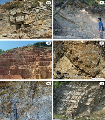
The succession evolves upwards into more open-marine deposits (outer-ramp to basinal environment) with sedimentation of platy limestones alternating with marlstones and fine-grained calcarenites of Turonian age (Filipović et al. Reference Filipović, Marković, Pavlović, Rodin and Marković1978). Finally, the succession passes into a basinal flysch consisting of low-density turbidite deposits (calcareous sandstones and calcirudites) and cherty limestones of Coniacian–Santonian age (Djerić et al. Reference Djerić, Gerzina, Gajić and Vasić2009; Vishnevskaya et al. Reference Vishnevskaya, Djerić and Zakariadze2009; Bragina et al. Reference Bragina, Bragin, Djerić and Gajić2014). Towards the Santonian portion of the succession, slumping layers and other syn-sedimentary deformations became common (Fig. 8a).
Outcrop photographs of the Mokra Gora, Guča and Kosjerić groups and of the Ljig flysch. (a) Slumped layer of calcarenite with cherty lenses in the upper portion of the Mokra Gora Group (Coniacian–Santonian), near Struganik village (Maljen massif area). (b) Fluvial conglomerates of the basal succession of the Kosjerić Group unconformably overlying the Drina–Ivanjica Palaeozoic phyllites, south of Kosjerić village. (c) Middle Turonian rudist-bearing reefal limestones, Kosjerić area; quarry cliff is ~40 m height. (d) Unconformable stratigraphic contact of the basal clastic succession of the Guča Group above the Palaeozoic phyllites of the Drina–Ivanjica Unit, Guča area. (e) Marly chaotic unit in the basal Guča Group with widespread centimetre- to decimetre-thick metamorphic clasts from the Drina–Ivanjica Unit; Phy – phyllite. Hammer for scale is 33 cm long. (f) Thick-bedded turbidite strata of the Ljig flysch (road-cut 2 km south of Ljig, see Fig. 2).

In the Struganik–Ba area, the Mokra Gora Group is overthrust by siliciclastic flysch of middle Campanian–Maastrichtian age (Ljig flysch; Dimitrijević & Dimitrijević, Reference Dimitrijević, Dimitrijević, Dimitrijević and Dimitrijević1987; Chiari et al. Reference Chiari, Djerić, Garfagnoli, Hrvatović, Krstić, Levi, Malasoma, Marroni, Menna, Nirta, Pandolfi, Principi, Saccani, Stojadinović and Trivić2011). This tectonic superposition is sealed, and thus postdated, by the Cenozoic intrusion of the Ba–Slavkovica quartz latites (Schefer et al. Reference Schefer, Cvetković, Fügenschuh, Kounov, Ovtcharova, Schaltegger and Schmid2010a; Chiari et al. Reference Chiari, Djerić, Garfagnoli, Hrvatović, Krstić, Levi, Malasoma, Marroni, Menna, Nirta, Pandolfi, Principi, Saccani, Stojadinović and Trivić2011).
3.b. Kosjerić Group
The Kosjerić Group (Chiari et al. Reference Chiari, Djerić, Garfagnoli, Hrvatović, Krstić, Levi, Malasoma, Marroni, Menna, Nirta, Pandolfi, Principi, Saccani, Stojadinović and Trivić2011) consists of a continental to transitional clastic unit passing upwards into bedded shallow-marine carbonates. The clastic unit is mainly composed of quartz pebbles and low-grade metamorphic clasts derived from subaerial erosion of the Palaeozoic formations located on the eastern flank of the Drina–Ivanjica Unit. Also, rare metre-sized slide blocks of shallow-water carbonates of presumably Triassic age were observed within the basal clastic unit (Kosjerić area). The contact with the underlying Drina–Ivanjica Unit and the ophiolite thrust sheets is marked by an angular unconformity (Fig. 8b).
The shallow-marine limestones gradually pass into a middle Turonian – lower Campanian marly basinal succession (Mojsilović et al. Reference Mojsilović, Baklajić, Đoković and Avramović1978; Radoičić & Schlagintweit, Reference Radoičić and Schlagintweit2007). A middle Turonian age was reported for an episode of shallow-water sedimentation characterized by massive reefal bioconstructions with abundant rudists, which is possibly heteropic with the basinal succession (Mojsilović et al. Reference Mojsilović, Baklajić, Đoković and Avramović1978). These typically reddish deposits are always bounded by tectonic contacts that hamper the recognition of the original stratigraphic relationships with the other lithofacies (Fig. 8c).
3.c. Guča Group
The Guča Group is represented by a basal formation characterized by littoral to slope clastic deposits unconformably lying above the Palaeozoic formations of the Drina–Ivanjica Unit (Fig. 8d) and partly above the pelagic sediments of the Kosjerić Group. The clasts in the basal succession are mainly represented by well-rounded quartz pebbles, phyllites and other low-grade metamorphic rocks along with lower amounts of dark grey limestones of possibly Triassic age. The basal clastic sediments pass upwards to shallow-marine carbonates that start with well-bedded limestones and calcarenites turning upwards into sporadic rudist-bearing massive limestones. The successive drowning of the carbonate platform is marked by deposition of thin-bedded calcareous litharenites interlayered with frequent slumps and debris flow deposits derived from the eroding Drina–Ivanjica formations (pre-flysch facies; Fig. 8e). Finally, basinal sedimentation is indicated by thick-bedded turbidite strata with arkose to lithic arkose composition. These turbidites stretch in a NNW–SSE direction from the Lučani area to the north, to the Majden area (North Macedonia) to the south and are known as the Kosovska–Mitrovica flysch (Dimitrijević & Dimitrijević, Reference Dimitrijević, Dimitrijević, Dimitrijević and Dimitrijević1987).
The Kosovska–Mitrovica flysch shares a similar age and petrographic composition with the Ljig flysch overthrusting the Mokra Gora Group to the south of the Maljen ophiolitic massif (Fig. 8f). In turn, Chiari et al. (Reference Chiari, Djerić, Garfagnoli, Hrvatović, Krstić, Levi, Malasoma, Marroni, Menna, Nirta, Pandolfi, Principi, Saccani, Stojadinović and Trivić2011) pointed out a correlation between the Ljig flysch and the Brus flysch partly corresponding to the Paraflysch Unit of Dimitrijević & Dimitrijević (Reference Dimitrijević and Dimitrijević2009) cropping out in the EVO and topping the structural pile in the Kopaonik area.
4. Bio- and chronostratigraphy of the Cretaceous ‘overstepping’ deposits
4.a. Material and methods
A total of 89 samples were collected in the Mokra Gora (67 samples), Kosjerić (5 samples) and Guča (17 samples) groups and studied for microfossil content after preparation of one thin-section for each sample. The sampling in the Mokra Gora Group in the Zlatibor area was taken every 1 m, on average, in the limestones of Unit A and every 5 m, on average, in Unit B. The sampling in the Kosjerić and Guča groups was scattered in different sections representative of their basal portions, just above the basal unconformity surfaces, and at the transition with the flysch sedimentation.
Scattered samples for the study of nannofossil assemblages were collected in the Mokra Gora Group, both in the Zlatibor (11 samples) and Maljen (6 samples) sections. The biozonations adopted for dating the calcareous nannofossil assemblages use the CC zones of Sissingh (Reference Sissingh1977). For each sample, the presence and abundance of each species was evaluated every 200 fields of observation (FOV).
Macrofossils (bivalves and gastropods) from the Mokra Gora succession sampled in the Zlatibor area were sampled from distinct levels, corresponding to individual beds or a series of a few beds, and prepared in the laboratory before taxonomic identifications. The samples of molluscs studied by Bortolotti et al. (Reference Bortolotti, Ficcarelli, Manetti, Passerini, Pirini-Radrizzani and Torre1971) are re-studied and revised herein.
4.b. Mokra Gora Group
The first studies of the Mokra Gora succession in the type area (Žujović, Reference Žujović1893; Petković, Reference Petkovic1925; Ampferer, Reference Amferer1928; Milovanović, Reference Milovanović1933) pointed to a latest Cretaceous age based on hippuritid bivalves and abundant fossil gastropod associations. Loczy (Reference Loczy1924), based on ammonites, was the first to recognize older ages for the lower part of the succession (Cenomanian–Turonian). Bortolotti et al. (Reference Bortolotti, Ficcarelli, Manetti, Passerini, Pirini-Radrizzani and Torre1971) studied the Vardište section and indicated a Late Jurassic age for the lower part of the succession (Unit A). Pejović & Radoičić (Reference Pejović and Radoičić1971) and Radoičić (Reference Radoičić1984) placed the lower part of the Mokra Gora succession (Unit B) as older than Cenomanian, and indicated a late Turonian to latest Cretaceous age for the upper part represented by massive limestones with hippuritids and gastropods (Unit C). Banjac (Reference Banjac1994a,b, Reference Banjac2000) and Banjac et al. (Reference Banjac, Bandel and Kiel2007, Reference Banjac, Jovanović, Dulić and Ljubović-Obradović2008) described Albian–Cenomanian mollusc faunas from the lower part of the succession. The same age was confirmed by I. Dulić (unpub. Ph.D. thesis, Univ. Belgrade, 2003) based on associations of palynomorphs. Finally, Radoičić & Schlagintweit (Reference Radoičić and Schlagintweit2007) erected the new dasycladalean species Neomeris mokragorensis from the Albian of the Mokra Gora succession and the Albian–Santonian of other localities.
In general, the previous investigations recognized only one regression–transgression cycle, and most of the time the analysed samples are not clearly located on a lithostratigraphic column. This hampered the unambiguous correlation with the results of this study. Comparison with previous biostratigraphic data was made only when the lithostratigraphic position within the succession was clearly indicated.
4.b.1. Unit A
No fossils were detected in subunit A1, whereas the poor preservation of bioclasts in subunit A2 hampered any age determination.
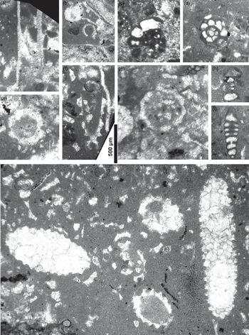
Fossils in subunit A3 are represented by the dasycladalean alga Salpingoporella dinarica Radoičić and Salpingoporella hasi Conrad, Radoičić & Rey, Rivulariaceae algae, the benthic foraminifers Hemicyclammina sigali Maync and Spiroloculina sp., and a moderately diverse assemblage of bivalves and gastropods (Fig. 9).
Thin-section photographs of microfossils in subunits A3–A4. (a, b) Salpingoporella dinarica Radoičić, sample MK7. (c) Hemicyclammina sigali Maync, sample MK_c. (d) Hemicyclammina sigali Maync, sample MK9. (e, g) Salpingoporella hasi Conrad, Radoičić & Rey, sample MK20. (f, j) Salpingoporella hasi Conrad, Radoičić & Rey, sample MK14. (h) Spiroloculina sp., sample MK9. (i) Undetermined foraminifer, sample MK9. Scale bar = 500 μm for all figures.

The range of S. dinarica is Berriasian to Albian with its acme in the Aptian, and the range of S. hasi is Aptian to Cenomanian (Carras et al. Reference Carras, Conrad and Radoičić2006). H. sigali is usually known from the Albian–Cenomanian (Sartorio & Venturini, Reference Sartorio and Venturini1988), but was originally reported from the Aptian–Cenomanian (Maync, Reference Maync1953; Loeblich & Tappan, Reference Loeblich and Tappan1988), while Hosseini et al. (Reference Hosseini, Conrad, Clavel and Carras2016) reported it from the Barremian of the Zagros Mountains (Iran). In addition, considering that the first occurrence of Neomeris mokragorensis Radoičić & Schlagintweit in the studied succession takes place 30 m upwards, in the lower part of subunit B3, and its range in Mokra Gora is middle–late Albian (Radoičić & Schlagintweit, Reference Radoičić and Schlagintweit2007), the age of subunit A3 can be attributed to the late Aptian. This dating agrees with the statement of Radoičić & Schlagintweit (Reference Radoičić and Schlagintweit2007) that ‘a latest Aptian age of the lowermost beds cannot be excluded’. Our data strengthen the presence of the Aptian, mainly because of the presence of S. dinarica, a species strongly present in the Aptian of the Dinarides–Hellenides.
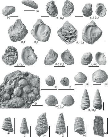
This age assignment is compatible with the benthic mollusc fauna of subunit A3, although it should be kept in mind that the longevity of the Mesozoic bivalve and gastropod species commonly spans distinctly more than a single stage, and even more so for genera. The molluscan fauna, as revised herein (Fig. 11), is dominated by various oysters (Amphidonte sp., Gyrostrea sp. and Flemingostreini gen. et sp. indet.), the bivalves Eomiodon sp. and Brachidontes sasykensis Romanov, and the gastropods Bicarinella bicarinata (Pchelintsev) and Pseudonerinea sp. While Amphidonte and Gyrostrea are typical Cretaceous oyster genera, Brachidontes sasykensis has been reported from the Barremian of the Dniester–Prut region (Romanov, Reference Romanov1976) and Bicarinella bicarinata from the Albian–Cenomanian of Mokra Gora (Banjac et al. Reference Banjac, Bandel and Kiel2007). A Late Jurassic age of subunit A3, as inferred by Bortolotti et al. (Reference Bortolotti, Ficcarelli, Manetti, Passerini, Pirini-Radrizzani and Torre1971), is no longer maintained according to our updated determinations.
Fossils in subunit A4 are represented by the dasycladalean alga Salpingoporella hasi, algae Solenoporaceae (Parachaetetes?) and Corallinaceae (Archaeolithothamnium?), and gastropods and bivalves. Because of the position, the age interval in which this subunit was deposited could be late Aptian to early Albian.
4.b.2. Unit B
Subunit B1 is barren of fossils. Subunit B2 yielded microfacies with no significant fossils, such as various benthonic foraminifers, Rivulariaceae algae, thick and thin bivalves, gastropods, ostracods and encrusters.
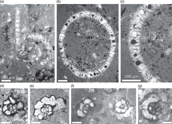
The lower part of subunit B3 yielded microfacies containing Neomeris mokragorensis, Salpingoporella hasi, Hemicyclammina sigali, Bacinella sp., rudist fragments, gastropods, ostracods and charophytes (Fig. 10). Pejović & Radoičić (Reference Pejović and Radoičić1971) recognized in this subunit Salpingoporella urladanasi Conrad, Peybernès & Radoičić, Bacinella sterni Radoičić and the benthic foraminifer Nezzazatinella cf. picardi (Henson). As mentioned above for subunit A3, the range of Neomeris mokragorensis in this area is middle–late Albian (Radoičić & Schlagintweit, Reference Radoičić and Schlagintweit2007). So, the lower part of subunit B3 can be considered to be middle Albian. This dating does not contrast with the ranges of the other species mentioned.
Thin-section photographs of microfossils in subunit B3. (a) Neomeris mokragorensis Radoičić & Schlagintweit, sample MK35. (b, c) Neomeris mokragorensis Radoičić & Schlagintweit, sample MK30 (c detail of b). (d) Hemicyclammina cf. sigali Maync, sample MK29. (e) Hemicyclammina cf. sigali Maync, sample MK31. (f) Hemicyclammina cf. sigali Maync, sample MK33. (g) Hemicyclammina sigali Maync, sample MK51. Scale bars = 300 μm.

In the lower part of subunit B3, gastropods occur in abundance, and although they are mostly poorly preserved, we could identify the species Bicarinella bicarinata, Cassiope kotromanensis (Banjac, Bandel & Kiel) and Paraglauconia lujani (de Verneuil & Collomb) with certainty (Fig. 11). The age of these gastropod species is given as Albian–Cenomanian by Banjac et al. (Reference Banjac, Bandel and Kiel2007). The bivalves Brachidontes sasykensis and Eomiodon sp., already mentioned for subunit A3, also occur in the lower part of subunit B3 in addition to oysters (Flemingostreidae gen. et sp. indet. and Curvostreini gen. et. sp. indet.) and locally abundant ‘Anomia’ sp. (Fig. 11).
Characteristic bivalves and gastropods from the Cretaceous of the Mokra Gora succession, western Serbia. (a) Brachidontes sasykensis Romanov, Reference Romanov1976, subunit A3, external view of right valve. (b) Brachidontes sasykensis Romanov, Reference Romanov1976, subunit A3, external view of left valve. (c) Gyrostrea sp., subunit A3; (c1) external view of left valve, (c2) external view of right valve. (d) Gyrostrea sp., subunit A3; (d1) external view of left valve, (d2) internal view of left valve. (e) Flemingostreini gen. et sp. indet., subunit A3; (e1) external view of right valve, (e2) internal view of right valve. (f) Flemingostreini gen. et sp. indet., subunit A3; (f1) external view of right valve encrusted by left valves of Amphidonte sp., (f2) internal view of right valve. (g) Amphidonte sp., subunit A3; (g1) external view of right valve, (g2) internal view of right valve. (h) Curvostreini gen. et sp. indet., subunit B3; (h1) external view of right valve, (h2) internal view of right valve. (i) Flemingostreidae gen. et sp. indet., subunit B3; (i1) external view of right valve, (i2) internal view of right valve. (j) Rock sample with several specimens of ‘Anomia’ sp. and poorly preserved Brachidontes and gastropod, subunit B3. (k) ‘Anomia’ sp., subunit B3 (same slab as in (j)). (l) ‘Anomia’ sp., subunit B3. (m) Eomiodon sp., subunit A3, external view of left valve. (n) Eomiodon sp., subunit A3, external view of right valve. (o) Eomiodon? sp., subunit B3; (o1) external view of left valve, (o2) external view of right valve. (p) Bicarinella bicarinata (Pchelintsev, Reference Pchelintsev1953), subunit B3; (p1) adapertural view, (p2) apertural view. (q) Bicarinella bicarinata (Pchelintsev, Reference Pchelintsev1953), subunit A3. (r) Cassiope kotromanensis (Banjac, Bandel & Kiel, Reference Banjac, Bandel and Kiel2007), subunit B3. (s) Cassiope kotromanensis (Banjac, Bandel & Kiel, Reference Banjac, Bandel and Kiel2007), subunit B3, adapertural view. (t) Paraglauconia lujani (de Verneuil & Collomb, Reference Verneuil and Collomb1853), subunit B3. (u) Paraglauconia lujani (de Verneuil and Collomb, Reference Verneuil and Collomb1853), subunit B3. (v) Pseudonerinea sp., subunit A3, polished section. Length of scale bars = 1 cm.

The upper part of subunit B3 is characterized by Hemicyclammina sigali, S. hasi, N. mokragorensis and Aeolisaccus sp. Radoičić & Schlagintweit (Reference Radoičić and Schlagintweit2007), among others, also recognized Ovalveolina maccagnoae De Castro, Atopochara trivolvis Peck, Charophyta gyrogonites, Pseudorhapydionina laurinensis (De Castro), Charentia cuvilleri Neumann, Cuneolina sp. and oysters. This fossil assemblage and its position suggests a middle Albian – earliest Cenomanian age for this part, in agreement with these authors.
Nannofossil assemblages from subunit B4 and the lower part of subunit B5 reported by Chiari et al. (Reference Chiari, Djerić, Garfagnoli, Hrvatović, Krstić, Levi, Malasoma, Marroni, Menna, Nirta, Pandolfi, Principi, Saccani, Stojadinović and Trivić2011) indicate an age no older than late Albian and no younger than late Coniacian. However, the presence of Pithonella ovalis (Kaufmann) in samples collected in subunit B4 and of S. cf. hasi up to the middle part of subunit B5 suggests that the age of subunits B4 and B5 is still within the late Albian–Cenomanian time span.
According to Radoičić & Schlagintweit (Reference Radoičić and Schlagintweit2007), subunit B6 is characterized by rare and poorly preserved ammonites, echinoderms, foraminifers (Hedbergella sp.) and other planktonic organisms (Pithonella sp.), resedimented fragments of rudists, other molluscs and halimedacean algae. Loczy (Reference Loczy1924) attributed a Cenomanian–Turonian age to this subunit.
4.b.3. Unit C
Pejović & Radoičić (Reference Pejović and Radoičić1971) attributed a late Turonian age to Unit C mainly on the basis of the assemblage of rudists (several species of Durania and Hippurites). From the upper part of this unit (not exposed in the studied section), Pejović & Radoičić (Reference Pejović and Radoičić1971) reported Biradiolites angulosissimus Toucas and various species of Durania of Santonian age.
In summary, the first unit of the Mokra Gora succession (Unit A) spans from late Aptian to early Albian in age, while a middle Albian to Cenomanian age is attributed to Unit B. Pejović & Radoičić (Reference Pejović and Radoičić1971) assigned a late Turonian to ?Santonian age to the shallow-marine deposits of Unit C.
4.c. Kosjerić Group
The lowermost portion of the shallow-marine limestones was sampled in the Kosjerić area some metres above the contact with the Palaeozoic formations of the Drina–Ivanjica Unit, giving a late Cenomanian age (Pseudolituonella reicheli Marie, Cuneolina pavonia D’Orbigny, Broeckina (Pastrikella) balcanica Cherchi, Radoičić & Schroeder, Vidalina radoicicae Cherchi & Schroeder, Chrysalidina gradata D’Orbigny and Heteroporella lepina Praturlon).
West of the Zlatibor Massif (near Ravni Village) some isolated outcrops of the Kosjerić Group seal the contact between the ophiolitic mélange and kilometre-sized slices of Triassic carbonates embedded in it (Sirogojno carbonate–clastic mélange of Missoni et al. Reference Missoni, Gawlick, Sudar, Jovanović and Lein2012). Samples from the basal portion of the carbonate unit confirm a late Cenomanian age (Chrysalidina gradata D’Orbigny, Cuneolina pavonia D’Orbigny, Minouxia cf. lobata Gendrot, Pseudonummoloculina heimi (Bonet), Pseudolituonella reicheli Marie and Pseudorhapydionina dubia (De Castro)). Radoičić & Schlagintweit (Reference Radoičić and Schlagintweit2007) and Dimitrijević et al. (Reference Dimitrijević, Ljubović-Obradović and Dimitrijević1996) attributed a similar age (Cenomanian–Turonian p.p.) to the shallow-water carbonates of the Kosjerić and Ravni areas.
4.d. Guča Group
Radoičić et al. (Reference Radoičić, Radulović, Rabrenović and Radulović2010) reported an earliest Campanian age for the base of the shallow-marine carbonate member.
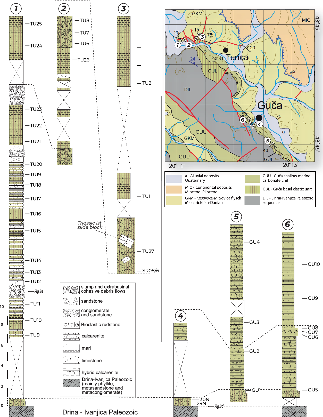
We studied in detail two sections located between Lučani and Guča villages (western Serbia) (Fig. 12). In these sections, 1–2 m of continental to littoral conglomerates rapidly passes upwards to distal ramp calcarenites and limestones and finally to basinal turbidites. The microfacies content consists of Moncharmontia apenninica (De Castro), Murgeina apula (Luperto Sinni), Orbitoides media (D’Archiac), Orbitoides apiculata Schlumberger, Siderolites calcitrapoides Lamarck, Hemicyclammina chalmasi (Schlumberger), Sulcoperculina sp., Goupillaudina sp., Minouxia sp., Globotruncana linneiana (D’Orbigny), ‘Stomiosphaera’ sphaerica (Kaufmann), biserial Heterohelicidae and Archaeolithothamnium sp., and allows the attribution of the carbonate members to the Campanian–Maastrichtian. Based on nannofossil assemblages sampled in the same section, Chiari et al. (Reference Chiari, Djerić, Garfagnoli, Hrvatović, Krstić, Levi, Malasoma, Marroni, Menna, Nirta, Pandolfi, Principi, Saccani, Stojadinović and Trivić2011) attributed a middle to late Campanian age to the pre-flysch facies of the succession. The comparison of these data allows the attribution of a late Campanian age to the continental to shallow-marine deposits of the Guča Group, whereas the Kosovska–Mitrovica flysch spans from the Maastrichtian to the Danian (ćirić, Reference Ćirić1958).
Measured and sampled sections of the Guča successions in the type area. Geological map from Chiari et al. (Reference Chiari, Djerić, Garfagnoli, Hrvatović, Krstić, Levi, Malasoma, Marroni, Menna, Nirta, Pandolfi, Principi, Saccani, Stojadinović and Trivić2011).

5. Comparison of the Mokra Gora, Kosjerić and Guča groups with other Cretaceous syn- to post-obduction deposits in the Dinaric orogen
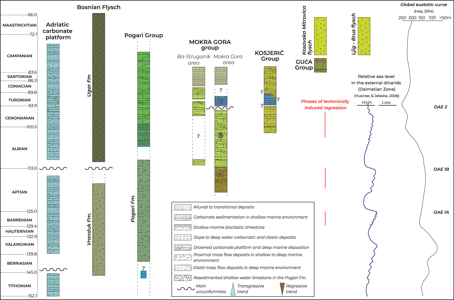
During the late stages of ophiolite obduction onto the eastern Adriatic margin, clastic sedimentation took place above the toe of the oceanic-derived thrust sheet (i.e. Pogari Group) and at the front of it (Vranduk Fm of the Bosnian flysch) (Fig. 13).
Correlation chart of the Cretaceous sedimentary successions in western Serbia and Bosnia. The long-term envelope of the sea level fluctuations (in metres above current sea level) is from Haq (Reference Haq2014). The phases of tectonically induced regressions are interpreted after the comparison between the stratigraphy of the Cretaceous successions in the Dinarides and the global eustatic curve (Haq, Reference Haq2014) and relative sea level oscillations recorded in the Tithonian to Cenomanian shallow-water carbonates of the AdCP (Husinec & Jelaska, Reference Husinec and Jelaska2006). New stratigraphic and age data presented in this work integrate the following literature: Adriatic carbonatic platform (Dinara Mountain section) after Vlahović et al. (Reference Vlahović, Tišljar, Velić and Matičec2005 with references); Vranduk and Ugar formations after Mikes et al. (Reference Mikes, Christ, Petri, Dunkl, Frei, Baldi-Beke, Reitner, Wemmer, Hrvatović and von Eynatten2008 with references); Pogari Group after Blanchet et al. (Reference Blanchet, Durand Delga, Moullade and Sigal1970), Blanchet (Reference Blanchet1975) and Hrvatović (Reference Hrvatović2006); Mokra Gora Group after (Ba–Struganik area) Vishnevskaya et al. (Reference Vishnevskaya, Djerić and Zakariadze2009), Djerić et al. (Reference Djerić, Gerzina, Gajić and Vasić2009) and Bragina et al. (Reference Bragina, Bragin, Djerić and Gajić2014) (Mokra Gora area) Pejović & Radoičić (Reference Pejović and Radoičić1971), Olujić et al. (Reference Olujić, Pamić and Kapeler1987), Radoičić & Schlagintweit (Reference Radoičić and Schlagintweit2007) and Banjac et al. (Reference Banjac, Bandel and Kiel2007); Guča Group and Ljig–Brus–Kosovska–Mitrovica flysch after ćirić (Reference Ćirić1958), Dimitrijević & Dimitrijević (Reference Dimitrijević, Dimitrijević, Dimitrijević and Dimitrijević1987), Radoičić et al. (Reference Radoičić, Radulović, Rabrenović and Radulović2010), Zelic et al. (Reference Zelic, Marroni, Pandolfi and Trivić2010) and Chiari et al. (Reference Chiari, Djerić, Garfagnoli, Hrvatović, Krstić, Levi, Malasoma, Marroni, Menna, Nirta, Pandolfi, Principi, Saccani, Stojadinović and Trivić2011). Chronostratigraphic chart after Cohen et al. (Reference Cohen, Finney, Gibbard and Fan2013). See text for discussion.

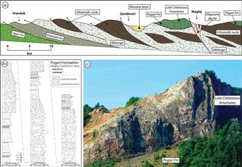
The Pogari Group crops out exclusively in the Maglaj–Žepče–Zavidovići area (Bosnia and Herzegovina) and lies unconformably above the ophiolitic mélange that in turn overthrusts to the SW the Vranduk Fm (Figs 2, 3, 14). The basal portion of the Pogari Group (Pogari Fm) consists of thick-bedded sandstones and conglomerates with ophiolite-derived clasts, reefal limestone blocks and red granite pebbles (Blanchet et al. Reference Blanchet, Durand Delga, Moullade and Sigal1970; Hrvatović, Reference Hrvatović2006). Sedimentary structures clearly suggest deposition through granular debris flows and high-density turbidity currents (Fig. 14b). In particular, the granite pebbles are well rounded suggesting that their spherical and rounded shape was obtained in a fluvial environment. A late Berriasian to early Albian age is attributed to this clastic succession (Blanchet, Reference Blanchet1975), whereas a Tithonian to Berriasian fauna was found in the reefal limestone blocks characterizing the base of the group. The basal clastic succession is topped by bioclastic limestone of Albian to Cenomanian age passing upwards into upper Cenomanian – lower Maastrichtian pelagic limestones (Blanchet et al. Reference Blanchet, Durand Delga, Moullade and Sigal1970; Blanchet, Reference Blanchet1975) (Fig. 14c).
(a) Geological cross-section along the Bosna Valley (Bosnia) detailed from cross-section C–C′ in Figure 3; see Figure 2 for location. (b) Stratigraphic column of the Pogari Fm in the Maglaj–Zavidovići area; grain-size abbreviations: sh. – shale; f.s. – fine sand; m.s. – medium sand; c.s. – coarse sand; pb. – pebble; bl. – boulder. (c) Upper Cretaceous detritic limestones and calcareous breccias unconformably resting above the upper portion of the Pogari Fm in the Šaj Kamen area (Bosna Valley).

The siliciclastic lower portion of the Pogari Group (Pogari Fm) is coeval with the base of the Bosnian flysch (i.e. the Vranduk Fm). With the latter, the Pogari Fm shares a very similar provenance based on the nature of the detrital components. As already proposed by Blanchet et al. (Reference Blanchet, Durand Delga, Moullade and Sigal1970), we favour the hypothesis that the Berriasian–Albian siliciclastic succession of the Pogari Group represents the proximal equivalent of the Vranduk Fm.
A similar linkage between the Pogari Fm and the Vranduk Fm can be proposed for the Oštrc and Bistra formations cropping out in the inselbergs near Zagreb (NW Dinarides) (Lužar-Oberiter et al. Reference Lužar-Oberiter, Mikes, Dunkl, Babić and Eynatten2012). The Oštrc Fm is of Barremian–Aptian age (Babić & Gušić, Reference Babić and Gušić1978) and is a turbiditic deposit that formed in a foredeep basin set onto the Pre-karst Unit and in front of the obducted Western Vardar ophiolites thrust sheets (Babić et al. Reference Babić, Hochuli and Zupanič2002). In a more internal position, the Bistra Fm represents a shallow-marine to transitional succession of carbonates and clastic sediments, which unconformably overlies the Western Vardar ophiolites thrust sheets facing the Oštrc Fm foredeep basin to the west (Babić et al. Reference Babić, Hochuli and Zupanič2002). Moreover, the Oštrc and Bistra fms show similar detrital ZFT populations of Early Cretaceous age that, similarly to what is envisaged for the Vranduk and Pogari fms (Neubauer et al. Reference Neubauer, Pamić, Dunkl, Handler and Majer2003; Mikes et al. Reference Mikes, Christ, Petri, Dunkl, Frei, Baldi-Beke, Reitner, Wemmer, Hrvatović and von Eynatten2008), suggest exhumation and erosion of portions of the Adria basement previously overthrust by the obducting oceanic lithosphere (Lužar-Oberiter et al. Reference Lužar-Oberiter, Mikes, Dunkl, Babić and Eynatten2012).
No clear correlation is evident between the Mokra Gora and Kosjerić groups and the Cretaceous successions exposed in the Zagreb area. Based on the lithostratigraphy, ages and nature of the substratum, a correlation could be tentatively proposed between the Guča Group and the Upper Cretaceous overstepping succession exposed in Medvednica Mountain (Crnjaković, Reference Crnjaković1979; Lužar-Oberiter et al. Reference Lužar-Oberiter, Mikes, Dunkl, Babić and Eynatten2012). The overstepping succession rests unconformably above low-grade metamorphic Palaeozoic to Triassic Adriatic units attributed to the Jadar–Kopaonik Unit (Schmid et al. Reference Schmid, Bernoulli, Fügenschuh, Matenco, Schefer, Schuster, Tischler and Ustaszewski2008), and consists of basal alluvial clastic sediments evolving upwards into hemipelagic shales and carbonates (Babić et al. Reference Babić, Gušić and Zupanič1976; Crnjaković, Reference Crnjaković1989) and, finally, into a Maastrichtian turbiditic sequence (Glog Fm; Lužar-Oberiter et al. Reference Lužar-Oberiter, Mikes, Dunkl, Babić and Eynatten2012).
Similarly, only a tentative correlation could be considered between the Ugar Fm and the Upper Cretaceous turbiditic deposits resting above the Pre-karst Unit west of Zagreb (Kravljak and Vivodina fms; Lužar-Oberiter et al. Reference Lužar-Oberiter, Mikes, Dunkl, Babić and Eynatten2012) of Albian–Cenomanian and Maastrichtian ages (Babić, Reference Babić1974; Devidé-Nedéla et al. Reference Devidé-Nedéla, Babić and Zupanič1982).
6. Discussion
Along the Dinaric–Hellenic chain, the widespread Lower to Upper Cretaceous sedimentary deposits, comprising clastic sediments to carbonates and shallow-marine to basinal settings, represent the seal of the obduction of the Western Vardar ophiolites above the continental units of Adria (Schmid et al. Reference Schmid, Bernoulli, Fügenschuh, Matenco, Schefer, Schuster, Tischler and Ustaszewski2008; Chiari et al. Reference Chiari, Djerić, Garfagnoli, Hrvatović, Krstić, Levi, Malasoma, Marroni, Menna, Nirta, Pandolfi, Principi, Saccani, Stojadinović and Trivić2011; Bortolotti et al. Reference Bortolotti, Chiari, Marroni, Pandolfi, Principi and Saccani2013; Nirta et al. Reference Nirta, Moratti, Piccardi, Montanari, Carras, Catanzariti, Chiari and Marcucci2018). The sedimentation of these deposits is diachronous on both oceanic and continental-derived units giving first-order constraints about the timing of syn- and post-obduction tectonic events.
The latest Jurassic to Late Cretaceous evolution of the Central Dinaric orogen is delineated below by comparing our detailed analyses of the Mokra Gora succession with the coeval deposits of the AdCP, the Kosjerić and Guča groups, the foredeep basin in front of the advancing imbricate thrust sheets and the ephemeral basins on top of the ophiolites.
6.a. Ophiolite obduction: Late Jurassic – Early Cretaceous
Obduction of the Western Vardar ophiolites onto the Adria continental margin was preceded by intraoceanic thrusting of the oceanic lithosphere accompanied by HT–LP metamorphism (Lanphere et al. Reference Lanphere, Coleman, Karamata and Pamić1975; Spray et al. Reference Spray, Bébien, Rex, Roddick, Dixon and Robertson1984; Smith et al. Reference Smith, Robertson and Mountrakis2006). In the southern sector of the Dinaric–Hellenic orogen the intraoceanic thrusting started in Middle Jurassic time, as testified by the age of the metamorphic soles lying below the ophiolite thrust sheet (160 Ma to 170 Ma in Serbia, Lanphere et al. Reference Lanphere, Coleman, Karamata and Pamić1975; Okrusch et al. Reference Okrusch, Seidel, Kreuzer and Harre1978; Borojević Šoštarić et al. Reference Borojević Šoštarić, Palinkaš, Neubauer, Cvetković, Bernroider and Genser2014; 162.1 ± 2.4 Ma to 174.0 ± 2.5 Ma in Albania, Dimo-Lahitte et al. Reference Dimo-Lahitte, Monié and Vergély2001; from 168 ± 2.4 Ma to 172.9 ± 3.1 Ma in Greece, Liati et al. Reference Liati, Gebauer and Fanning2004). The time span of the subsequent involvement of continental crust is constrained by the age of the youngest continental-derived slices embedded in the sub-ophiolitic mélange and the oldest ophiolite-bearing clastic deposits stratigraphically lying above the more internal sectors of the Adriatic continental margin. In the Nova Varoš–Bistrica area (western Serbia) continental-derived radiolarites of Callovian–early Kimmeridgian age cropping out as blocks inside the sub-ophiolitic mélange date the onset of ophiolite obduction above continental units to latest Jurassic time (Obradović et al. Reference Obradović, Milovanović and Vasić1986; Obradović & Goričan, Reference Obradović, Goričan, Hein and Obradović1988; Djerić et al. Reference Djerić, Gerzina and Schmid2007). Some authors suggested that the obduction was already active in Middle Jurassic – early Late Jurassic times on the basis of the age of the sheared matrix of the mélange (Gawlick et al. Reference Gawlick, Missoni, Suzuki, Lein, Sudar and Jovanović2016, Reference Gawlick, Missoni, Sudar, Gorican, Lein, Stanzel and Jovanović2017a,b; Gawlick & Missoni, Reference Gawlick and Missoni2019). In this view the obduction would be coeval with, or rapidly following, the intraoceanic thrusting forming the amphibolite sole (Aalenian–Oxfordian). However, because the mélange is characterized by pervasive deformation, in our view the ages of both the matrix and embedded blocks only allow the pre-dating of their involvement in the mélange.
Late Jurassic – Early Cretaceous obduction onto the Adriatic continental margin is in accordance with the widespread uplift of the AdCP followed by emersion events and syn-sedimentary tectonics of Kimmeridgian–Tithonian age (Vlahović et al. Reference Vlahović, Tišljar, Velić and Matičec2005) (Fig. 13). This broad uplift was followed in late Tithonian – early Berriasian times by rapid subsidence and the development of a foreland basin in front of the obducted ophiolite nappes. The turbiditic deposits of the upper Tithonian to Aptian Vranduk Fm of the Central Dinarides were deposited in this foreland basin that formed in the Pre-karst Unit, which experienced pelagic sedimentation from late Early Jurassic time (Blanchet et al. Reference Blanchet, Cadet, Charvet and Rampnoux1969; Blanchet, Reference Blanchet1970; Hrvatović, Reference Hrvatović1999; Mikes et al. Reference Mikes, Christ, Petri, Dunkl, Frei, Baldi-Beke, Reitner, Wemmer, Hrvatović and von Eynatten2008) (Fig. 15a). This formation correlates well with the Barremian–Albian Oštrc Fm in the northwestern internal Dinarides (Lužar-Oberiter et al. Reference Lužar-Oberiter, Mikes, Dunkl, Babić and Eynatten2012) and, further south, with the Boeotian flysch (Tithonian–Aptian, Celet et al. Reference Celet, Clément and Ferrière1976; Nirta et al. Reference Nirta, Moratti, Piccardi, Montanari, Catanzariti, Carras and Papini2015). At the same time, short-lived and sporadic carbonate platforms developed on top of the obducted ophiolite nappe, which were then dismantled and resedimented in the Early Cretaceous pelagic basins (e.g. Pogari Fm).
Schematic geodynamic reconstruction of the internal Dinarides during Late Jurassic–Cretaceous times. (a–d) represent consecutive time steps in the evolution of the internal Dinarides; (e, f, g) are zoomed in parts of (d) representing the Late Cretaceous reconstructions in the Mokra Gora and Guča–Kosjerić areas, respectively. See text for discussion.

Obduction was accompanied by offscraping of large portions of the Adriatic passive margin that were subsequently embedded in the mélange complex below the overriding ophiolite nappe. The continental-derived elements involved in the mélange are mainly represented by Triassic shallow-water and pelagic limestones along with lower percentages of Lower Jurassic limestones, Middle Jurassic radiolarites and low-grade metamorphic rocks. These elements, along with the ocean-derived sedimentary and igneous rocks, are embedded in a shaly matrix. Limited outcrops of weathered and brecciated red granites are reported in the mélange outcrops east of the Zlatibor Massif (Radovanović et al. Reference Radovanović, Popović, Jovanović and Jovanović1997) and as blocks within the basal clastic sequence of the Pogari Fm in the Maglaj area (Bosnia and Herzegovina; Neubauer et al. Reference Neubauer, Pamić, Dunkl, Handler and Majer2003). The absence of continental-derived terrigenous fragments in the basal portions of the Mokra Gora Group suggests that the source of continental-derived inputs within the Pogari Fm and Vranduk Fm was located in continental tectonic slices embedded in the ophiolitic mélange at the base of the ophiolite nappe during obduction and later on was almost completely eroded.
During the obduction, the ophiolites and mélange were partly located in shallow-marine environments and formed the substratum for isolated carbonate platforms that underwent subsequent rapid dismantling under an active tectonic regime (Fig. 15a) (Schlagintweit et al. Reference Schlagintweit, Gawlick, Lein, Missoni and Hoxha2012; Nirta et al. Reference Nirta, Moratti, Piccardi, Montanari, Carras, Catanzariti, Chiari and Marcucci2018). Carbonate fragments with neritic faunas of Tithonian–Berriasian age characterize the basal clastic member of the Pogari Fm (Jovanović, Reference Jovanović1961; Blanchet et al. Reference Blanchet, Durand Delga, Moullade and Sigal1970) (Fig. 13). At the time of deposition these carbonate fragments were not completely lithified (Blanchet, Reference Blanchet1975), and they partially enclosed lithic fragments of ophiolite, cherts and peraluminous granites (Brlek et al. Reference Brlek, Balen and Bermanec2010), which, in turn, probably represented the substratum lithologies of the dismantled carbonate platform. Shallow-water carbonate lithoclasts of earlier Cretaceous age were also reported at the base of the Vranduk Fm (Blanchet et al. Reference Blanchet, Cadet, Charvet and Rampnoux1969). As previously proposed by Blanchet (Reference Blanchet1970), the basal clastic member of the Pogari Fm could be interpreted as the proximal facies of the Vranduk Fm turbidite system. In particular, the base of the Pogari Group is represented by granular debris flow deposits and coarse-grained high-density turbidite deposits. Dismantling of the isolated carbonate platforms coincides with the rejuvenation of compressional tectonics and the formation of a turbiditic foredeep basin in front of the obduction thrust sheet (Fig. 15a). Tectonic imbrication related to the terminal stage of obduction was also responsible for the exhumation of slices of Adriatic continental crust and their successive involvement in the thrust wedge. This tectonically complex scenario is reflected in the nature of lithic fragments that characterize the Lower Cretaceous clastic wedges. Both the Vranduk Fm and the basal part of the Pogari Fm probably shared common source areas characterized by clastic input from the ophiolites, mélange, isolated carbonate platforms and from low-grade metamorphic rocks of continental affinity.
6.b. Late Aptian – early Albian
The inner part of the obduction-related nappe stack was widely emergent during Early Cretaceous time, as testified by the widespread laterite deposits on top of the ophiolites (Photiades et al. Reference Photiades, Carras, Bortolotti, Fazzuoli and Principi2007; Nirta et al. Reference Nirta, Moratti, Piccardi, Montanari, Carras, Catanzariti, Chiari and Marcucci2018). The serpentinites of the Zlatibor Massif suffered intense erosion in an arid climate, as also testified by the metre-thick silcrete duricrusts at the base of the Mokra Gora succession (Bortolotti et al. Reference Bortolotti, Ficcarelli, Manetti, Passerini, Pirini-Radrizzani and Torre1971). Prolonged emersion, along with the coarse-grained fluvial deposits of Mokra Gora subunits A1 and A2 that were exclusively derived from exposed ophiolites, presumably point to a dominating compressional tectonic regime. Seaward discharge by high-energy rivers represents the source of the ophiolitic detritus in the turbiditic beds of the Pogari Fm and in the topmost part of the Vranduk Fm.
The onset of deposition above the Zlatibor ophiolite is poorly constrained because of the absence of datable fossils in the overlying clastic deposits (i.e. in subunits A1 and A2 of the Mokra Gora Group). However, assuming that the prolonged emersion phase is contemporaneous with the tectonic pulses that led to the definition of the Vranduk and Pogari basins, the clastic strata above the obducted ophiolites could be tentatively attributed a Berriasian–Aptian age. From Tithonian to the early Aptian times, compressive tectonic pulses along with eustatic changes are recorded in the AdCP as short-lasting emersion events (Vlahović et al. Reference Vlahović, Tišljar, Velić and Matičec2005).
A prominent late Aptian flooding surface (FS1; Fig. 6) marks the onset of transgression in the Mokra Gora area. Generally, the age of the ‘transgression’ deposits is slightly diachronous along the Dinaric–Hellenic chain, and also over short distances. At Zyghosti (northern Greece) it varies from early Aptian to late Albian (Bortolotti et al. Reference Bortolotti, Carras, Chiari, Fazzuoli, Photiades and Principi2004; Carras et al. Reference Carras, Fazzuoli and Photiades2004), and in the Mirdita area (northern Albania) it is early Aptian (Schlagintweit et al. Reference Schlagintweit, Gawlick, Lein, Missoni and Hoxha2012). Younger ages for the basal limestones described in the Mokra Gora area by several authors (Pejović & Radoičić, Reference Pejović and Radoičić1971; Banjac, Reference Banjac1994a; Radoičić & Schlagintweit, Reference Radoičić and Schlagintweit2007) refer to samples collected in the overlying subunits B2 and B3.
Whether the deepening of the depositional setting recorded within Unit A was linked to an extensional event or to a sea level rise is not clearly established. The long-term sea level curve (Haq, Reference Haq2014) displays for the whole Aptian through early Albian a period of relatively high and stable sea level, whereas short-term fluctuations could barely be verified within the A2 to A3 transition owing to the poor age calibration of the studied section (Fig. 13). The long-term trend of the sea level curve is in accordance with the lower Aptian deposits of the AdCP, which represent a clearly recognizable regional event connected with eustatic sea level rise, with partial drowning of the platform (Vlahović et al. Reference Vlahović, Tišljar, Velić and Matičec2005). This fits well with the early Aptian oceanic anoxic event (OAE-1a; Jenkyns, Reference Jenkyns1980; Jones & Jenkyns, Reference Jones and Jenkyns2001). However, even if regional data point to a period of sea level highstand, the influence of extensional tectonics, probably related to adjustment towards a stable taper geometry of the thrust wedge after the terminal obduction stage, cannot be excluded. Seaward, the sedimentation in the deep-sea top wedge basin (i.e. the Pogari Fm) and in the pro-wedge basins (i.e. the Vranduk Fm) continued without remarkable changes until late Aptian time.
At the Aptian–Albian transition the sedimentary environment in Mokra Gora shifted abruptly from shallow marine to terrestrial (subunit B1) (Fig. 15a, b). This environmental change is coeval with a regional event of subaerial exposure and erosion of the AdCP (Vlahović et al. Reference Vlahović, Tišljar, Velić and Matičec2005) and with the angular unconformity separating the Upper Cretaceous Ugar Fm from the previously deformed Lower Cretaceous Vranduk Fm. The transition from the Vranduk Fm to the Ugar Fm marks a rapid transition from siliciclastic- to carbonate-dominated sedimentation, with an inferred source area in the AdCP (Aubouin, Reference Aubouin1973; Mikes et al. Reference Mikes, Christ, Petri, Dunkl, Frei, Baldi-Beke, Reitner, Wemmer, Hrvatović and von Eynatten2008).
Similarly, within the pelagic Pogari succession the sedimentation shifted from siliciclastic-dominated turbidites to a calcarenite and carbonatic breccia succession testifying to the dismantling of the penecontemporaneous shallow-water carbonate platforms probably located in the inner sectors (Fig. 15c).
Abrupt changes in sedimentary environment and unconformities are coeval with the main deformational events along the internal part of the orogen. Very low-grade to greenschist-facies Early Cretaceous orogen-scale metamorphism is recorded in the Medvednica Mt. inselberg within the Adria-derived continental units underlying the obducted Western Vardar ophiolites (i.e. the Jadar–Kopaonik Unit, Schmid et al. Reference Schmid, Bernoulli, Fügenschuh, Matenco, Schefer, Schuster, Tischler and Ustaszewski2008; 118 ± 4 Ma K–Ar age, Belak et al. Reference Belak, Pamić, Kolar-Jurkovšek, Peckay and Karan1995; 135–110 Ma Rb–Sr age, van Gelder et al. Reference van Gelder, Matenco, Willingshofer, Tomljenović, Andriessen, Ducea, Beniest and Gruić2015 with references therein). Evidence of Early Cretaceous metamorphism was also obtained in the Drina–Ivanjica Unit (139–129 Ma K–Ar age, Milovanović, Reference Milovanović1984) and in the Adria-derived continental units of the Mid-Bosnian Schist Mountains (121–95 Ma, Pamić et al. Reference Pamić, Balogh, Hrvatović, Balen, Jurković and Palinkaš2004). Moreover, provenance studies and thermochronology analyses on detrital minerals from the Ljig flysch, Vranduk Fm and Oštrc Fm indicate the existence of exhumed continental fragments of the Adria Plate margin that were affected by a tectonic event of Early Cretaceous age (Ilić et al. Reference Ilić, Neubauer and Handler2005; Mikes et al. Reference Mikes, Christ, Petri, Dunkl, Frei, Baldi-Beke, Reitner, Wemmer, Hrvatović and von Eynatten2008; Lužar-Oberiter et al. Reference Lužar-Oberiter, Mikes, Dunkl, Babić and Eynatten2012).
All this points to a regional tectonic event associated with metamorphism, exhumation and erosion of continental fragments of the distal part of the Adria Plate. This tectonic event is also recognized in the southern sectors of the chain (Albanian–Hellenic belt) where it was alternatively linked to obduction-related nappe stacking (Robertson & Dixon, Reference Robertson, Dixon, Dixon and Robertson1984; Robertson et al. Reference Robertson, Clift, Degnan and Jones1991; Kilias et al. Reference Kilias, Frisch, Avgerinas, Dunkl, Falalakis and Gawlick2010; Robertson, Reference Robertson2012) or to the final collision of the Adria Plate with the Rhodope massif (Eurasia Plate) (Jacobshagen & Wallbrecher, Reference Jacobshagen, Wallbrecher, Dixon and Robertson1984; Papanikolaou, Reference Papanikolaou1997, Reference Papanikolaou2009; Meinhold et al. Reference Meinhold, Kostopoulos, Reischmann, Frei and BouDagher-Fadel2009; Bortolotti et al. Reference Bortolotti, Chiari, Marroni, Pandolfi, Principi and Saccani2013; Schenker et al. Reference Schenker, Fellin and Burg2015; Nirta et al. Reference Nirta, Moratti, Piccardi, Montanari, Carras, Catanzariti, Chiari and Marcucci2018). In the Central Dinaric sector, a complete closure of the northern branch of the Neotethys during Early Cretaceous time should be discarded, because evidence of Upper Cretaceous ophiolites was found in the Sava zone (Kozara Mountains, northern Bosnia; Schmid et al. Reference Schmid, Bernoulli, Fügenschuh, Matenco, Schefer, Schuster, Tischler and Ustaszewski2008; Ustaszewski et al. Reference Ustaszewski, Schmid, Lugovic, Schuster, Schaltegger, Bernoulli, Hottinger, Kounov, Fügenschuh and Schefer2009). However, Upper Cretaceous ophiolites of the Kozara Mts could represent relics of an oceanic sector located between Adria and the Tisza continental block that was preserved after the Early Cretaceous continental collision in the Albanian and Hellenic sectors of the orogen (Bortolotti et al. Reference Bortolotti, Chiari, Marroni, Pandolfi, Principi and Saccani2013; Nirta et al. Reference Nirta, Moratti, Piccardi, Montanari, Carras, Catanzariti, Chiari and Marcucci2018) rather than witnessing the persistence throughout Late Cretaceous time of an open oceanic basin along the whole Dinaric–Hellenic belt.
6.c. Early Albian–Turonian
After the regionally recognized Aptian tectonic phase in the internal Dinarides, an extensional collapse of the Early Cretaceous nappe stack started in Albian time. Subunits B2 and B3 of the Mokra Gora succession depict this collapse with a new transgressive phase that reached its climax with the B3* anoxic level (maximum flooding surface).
From early Cenomanian time, the Mesozoic sedimentary cover of the Drina–Ivanjica Unit and the previously obducted oceanic units were eroded, and large portions of the underlying Palaeozoic crystalline basement were exhumed and exposed to subaerial conditions (Fig. 15d). Above this substratum, thick clastic successions of fluvial sediments were deposited (basal succession of the Kosjerić Group). Rock fragments of the fluvial deposits are mainly represented by well-rounded quartz pebbles, possibly resulting from reworking of the mature clastic deposits of Palaeozoic age characterizing the Drina–Ivanjica succession (Kovilje conglomerates; Trivić et al. Reference Trivić, Cvetković, Smiljanić and Gajić2010).
The following transgressive phase above the basal clastic succession of the Kosjerić Group starts during early Cenomanian time with shallow-water carbonate sedimentation and depicts a generally deepening cycle until Campanian time, with an intervening shallow-water episode of a rudist-bearing carbonate platform in Turonian time (Fig. 15f).
The beginning of the transgressive trend in the Kosjerić Group is coeval with the regressive trend recorded in the Mokra Gora Group, starting with calcareous turbiditic sedimentation of subunit B4. The reconstruction of the stratigraphic evolution of the Mokra Gora and Kosjerić groups from early Cenomanian to Turonian times allowed hypothesizing a model of exhumation for the Drina–Ivanjica Unit through a growing antiformal structure (Fig. 15d). The sedimentary basins located in the forelimb sector (i.e. Mokra Gora area) were dominated by compression leading to a forced regression (Fig. 15e), whereas the backlimb sectors were affected, after exposure to subaerial conditions, by the collapse of the hanging wall units, thus leading to a relative sea level rise (i.e. Kosjerić area; Fig. 15f). This antiformal structure is most likely linked with the westward-propagating thrusting of the Drina–Ivanjica Unit above the Durmitor Unit (Schmid et al. Reference Schmid, Bernoulli, Fügenschuh, Matenco, Schefer, Schuster, Tischler and Ustaszewski2008).
Exhumation of the Drina–Ivanjica Unit under a compressional regime better explains the sedimentary evolution of the Kosjerić Group at this time rather than a sea level fall. In fact, the Cenomanian/Turonian boundary, usually correlated with OAE2, is regionally related to a eustatic sea level rise (Jenkyns, Reference Jenkyns1991; Simon & Jenkyns, Reference Simon and Jenkyns1999; Vlahović et al. Reference Vlahović, Tišljar, Velić and Matičec2005). Additionally, within the coeval successions of the AdCP, generally recording an episode of a deep-marine carbonate setting, tectonic influences are also recognized (Jež et al. Reference Jež, Otoničar, Fuček and Ogorelec2011).
The tectonically induced regression reached its climax with the formation of shallow-water carbonate platforms both in the Kosjerić and Mokra Gora successions (Unit C) during Turonian–? Coniacian times (Fig. 15e, f). At the front of the obduction nappe stack the Pogari and Ugar successions persisted in open-marine conditions (Fig. 15e).
6.d. Coniacian–Maastrichtian
From ?Coniacian–Santonian times, a rapid basin deepening is recorded in the Kosjerić and Mokra Gora groups and was accompanied by the deposition of thin-bedded calcareous turbidites until latest Cretaceous time.
At the same time, along the eastern border of the Drina–Ivanjica antiformal bulge, the Guča Group started above the Palaeozoic basement with littoral clastic deposition rapidly passing into turbiditic sedimentation in a slope setting and subsequently into pelagic conditions. The transgressive trend of the Guča Group is consistent with the general deepening in the whole Dinaric sector of the belt (Fig. 15g).
The common occurrences of syn-sedimentary deformations and chaotic deposits (slide blocks, debris flows) within the Santonian–Campanian slope deposits of the Mokra Gora and Guča groups suggest renewed tectonic activity.
From middle Campanian time, flysch sedimentation dominated in the whole inner Dinarides, heralding the Late Cretaceous–Paleocene tectonic phase that finally led to the closure of oceanic remnants located between Adria and the Eurasian margin (Schmid et al. Reference Schmid, Bernoulli, Fügenschuh, Matenco, Schefer, Schuster, Tischler and Ustaszewski2008; Ustaszewski et al. Reference Ustaszewski, Schmid, Lugovic, Schuster, Schaltegger, Bernoulli, Hottinger, Kounov, Fügenschuh and Schefer2009).
7. Final remarks
The reconstruction of the sedimentary history of the basins established from late Early Cretaceous time on top of the ophiolite thrust sheets of the obducted Western Vardar unit allowed the unveiling of a complex tectonic and sedimentary scenario related to the obduction and the response of the underlying continental crust. Comparison with partly coeval sedimentary basins developed on the front of the ophiolite nappe and in the more internal sectors of the Dinaric–Hellenic orogenic system allows the reconstruction of the main phases of the geodynamic evolution of the internal Dinarides in the following way:
(1) Continuing tectonic activity from latest Jurassic to late–middle Aptian times allowed terrestrial sedimentation on the emergent portions of the ophiolite nappe contemporaneous with the existence of sporadic and short-lived carbonate platforms that were soon after eroded and became a source of the carbonate debris deposited in deep-marine environments. The load of the obducted ophiolite unit caused the bending of the Adria continental lithosphere, allowing the formation of a foreland basin in front of the tectonic pile that was filled by turbidites from Berriasian time (the Vranduk Fm).
(2) A prominent tectonic phase of late Early Cretaceous age is recorded by widespread deformation, unconformities, erosion and a regional very low-grade metamorphism in the whole Dinaric–Hellenic belt. We link this tectonic climax with the closure of the main segment of the Neotethys Ocean in the Albanian and Hellenic sectors and collision between Adria and the Eurasian margin. However, a small oceanic realm located between Adria and the Tisza continental block escaped complete closure until latest Cretaceous time.
(3) The collapse of the Early Cretaceous orogen triggered the formation of carbonate platforms above the Internal Dinaric Units sealing the previous deformation (i.e. Mokra Gora Group).
(4) A renewed tectonic pulse in late Albian–Cenomanian times caused the exhumation of a large portion of the Adria continental margin previously thrust by obducted Western Vardar ophiolites, by out-of-sequence thrusting and the formation of a mega-anticline (i.e. the Drina–Ivanjica Unit). This post-obduction and WSW-directed thrusting resulted in the tectonic superposition of the Drina–Ivanjica Unit above the Durmitor Unit to the west. Exhumation of the Drina–Ivanjica Unit was accompanied by erosion and weathering and clastic sedimentation in subaerial conditions, followed by a new transgressive phase from early Cenomanian time (Kosjerić and Guča groups).
(5) The widespread flysch sedimentation of Campanian age in all the internal Dinarides marks the beginning of the prominent Late Cretaceous–Paleocene tectonic phase, which finally led to the complete closure of the central Dinaric segment of the northern branch of the Neotethys Ocean and the collision between the Dinarides and the Tisza block along the Sava suture zone.
Acknowledgements
The authors would like to thank Raika Radoičić for the fruitful discussions about the Cretaceous biostratigraphy of the Dinarides, and Stefano Dominici for his precious help in sample management. This work is dedicated to the memory of Prof. Nenad Banjac who introduced us to the world of Cretaceous successions of Serbia. Hans-Jürgen Gawlick and Bruno Tomljenović are gratefully acknowledged for their reviews and helpful suggestions that have greatly improved an earlier version of the manuscript. This research has been supported by the MIUR-PRIN Project 2006 ‘Structural and stratigraphic studies on the Dinaric (Serbia–Montenegro), Hellenic (Epiro–Macedonia–Tessaly) chains and Crete. Comparison with those of Albanids and Southern Hellenids’.
Declaration of interests
The authors declare that they have no known competing financial interests or personal relationships that could have appeared to influence the work reported in this paper.