

What became known variously as “The Sri Lanka problem”, “The Sri Lanka question”, and “The Sri Lanka suggestion” during the Eighth and Ninth Sessions of the Third United Nations Conference on the Law of the Sea, was one of the “core problems” dealt with by the Second Committee presided over by Chairman (later Judge) Andres Aguilar. The issue arose out of a growing awareness that provisions on the delimitation of the continental shelf in Article 76 of the emerging Draft ConventionFootnote 1 could have inequitable consequences when applied to Sri Lanka's continental shelf, which had been demonstrated to be geologically and geomorphologically different in terms of the depth and distance constraints to which the Article had been intended to apply. As awareness of the facts spread among the various interest groups of states represented at the Conference, Sri Lanka was able to negotiate an equitable solution to the issue that is now incorporated in the “Statement of Understanding concerning a specific method to be used in establishing the outer edge of the continental margin” (SoU),Footnote 2 adopted by consensus at the 141st Plenary Meeting of the Conference on 29 August 1980, and referred to in paragraph 3(1)(a) of Annex II (Commission on the Limits of the Continental Shelf) to the 1982 UN Convention on the Law of the Sea (Convention).
By the Spring Session of the Conference in 1978, the “Definition of the Continental Shelf” in paragraph 1 of Article 76 had been agreed to and was set to become part of the final text of the Convention:
The continental shelf of a coastal State comprises the sea-bed and subsoil of the submarine areas that extend beyond its territorial sea throughout the natural prolongation of its land territory to the outer edge of the continental margin, or to a distance of 200 nautical miles from the baselines from which the breadth of the territorial sea is measured where the outer edge of the continental margin does not extend up to that distance.Footnote 3
What the Second Committee was not yet able to agree upon was how to delimit and delineate the maximum seaward extension of the continental shelf, which paragraph 1 of Article 76 declared could be coterminous with the continental margin.
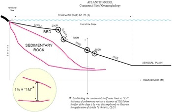
As support began to crystallize around the alternative delimitation methods provided for in what became paragraphs 4(a) and 4(b) of Article 76, and the related distance and depth constraints prescribed in what became paragraph 5 of Article 76, a map circulating at the Conference, prepared by geologists at Columbia University, focused the interest and the concern of some developing countries. A line on the map, drawn in accordance with what became paragraph 4 of Article 76, graphically demonstrated the adjacent submarine areas some countries should expect to lose if those provisions were applied to their continental margins.
I. Sri Lanka Calls For Equitable Treatment
Dr Hiran Jayewardene, representing Sri Lanka at the Conference, set out the parameters of Sri Lanka's call for equitable treatment that would guide its initiative on the delimitation issue until its final accommodation by the Conference. He asserted that Sri Lanka:
accepted the rationale of the Irish formula, but had some difficulty with regard to its application. In [Sri Lanka's] view, the combined distance–sedimentary layer–thickness criterion could produce equitable results only in cases where the margin thinned out rapidly. It could cause injustice in cases of countries, such as his, where the continental margin was wide and of considerable thickness throughout. No mathematical formula could claim a universal and equitable application in view of the highly varied geographical, geomorphological and geological conditions existing in the world. His delegation had raised several objections to that formula. They were of a technical nature and had been set out in its analysis of the Irish formula during the deliberations of Negotiating Group 6. His delegation was prepared to accept the Irish formula as a basis for negotiation and perhaps as a general rule, provided that the case of Sri Lanka was treated as a special circumstance and an exception thereto, since a rigid application of the Irish formula would deprive his country of a vast extent of its continental margin … but it should not be expected to make an unreasonable and unjustifiable sacrifice of its interests.Footnote 4
II. Negotiating Equitable Treatment
Negotiation of an exception to Article 76 that would secure equitable treatment for Sri Lanka took place: (1) bilaterally with the two most influential states at the Conference, the US and the Soviet Union; (2) among a group of broad-margin states, known as the “Margineers”, which had similar interests;Footnote 5 (3) among the members of an open-ended Negotiating Group 6 established by the Second Committee; and (4) among the members of a smaller group of thirty-eight states, which were also presided over by the Chairman of the Second Committee.Footnote 6
Sri Lanka presented its case in bilateral exchanges as well as in groups of interested states along lines foreseen in Dr Jayewardene's plenary statement seeking, on the basis of geomorphic and geological evidence, either to introduce a third subparagraph—in what became Article 76, paragraph 4—that would permit inclusion within the limits of Sri Lanka's continental shelf/margin of the equivalent in resource potential acquired by other broad margin states by operation of Article 76, paragraph 4. Alternatively, Sri Lanka sought a separate textual exemption from the provisions of that Article. To that end, Sri Lanka presented to the Conference in April 1979, an aide-mémoire containing a summary of its arguments.Footnote 7
Bilateral talks with the US and the Soviet Union revealed that both countries were willing to support Sri Lanka's efforts and even provide necessary scientific advice and assistance. However, the Soviet Union, apparently motivated by security concerns, urged that Sri Lanka should abide by the overall limit of 350 nautical miles from territorial sea baselines prescribed by Article 76,
The group of broad-margin states was generally supportive of Sri Lanka's initiative. Still, given the difficulties encountered and resolved in drafting Article 76, they did not favour amendment of its provisions as a means of accommodating Sri Lanka's initiative.Footnote 8
Nevertheless, Sri Lanka, in the course of negotiations in the Group of 38 and Negotiating Group 6 reported on by Second Committee Chairman Aguilar under the heading “The Problem of Sri Lanka”, did propose, at the Eighth Session of the Conference, the inclusion—in what became Article 76(4)(a)—of a third subparagraph which would provide for an additional alternative method of delimitation applicable to its specific geological and geomorphological conditions.Footnote 9 As reported by Chairman Aguilar, the proposal foreshadows the text of the SoU in that it would have allowed Sri Lanka to extend the limit of its continental shelf “to a line delineated on the basis of outermost fixed points where the thickness of the sedimentary rock was not less than 0.8 kilometre”.Footnote 10
A. The Problem of Sri Lanka
This question regarding Sri Lanka and delimitation was referred to in a footnote to paragraph 4(a) of Article 76. As indicated in the footnote, the suggestion of the delegation of Sri Lanka for an additional method of delimitation applicable to its geological and geomorphological conditions had received widespread sympathy during the first part of the Eighth Session. The question was considered both in Negotiating Group 6 and in the Group of 38. Sri Lanka submitted a new informal proposal, known as NG6/10, to add a new subparagraph (iii) to paragraph 4(a) of Article 76. According to that proposal, in the case of a state where the mathematical average of the thickness of sedimentary rocks along the outer edge of the continental margin established at the maximum distances set in paragraph 4 was not less than 3.5 kilometres, and where more than half of the margin lay beyond the outer edge as so delineated, the outer limit of the continental shelf would extend to a line delineated on the basis of the outermost fixed points where the thickness of the sedimentary rocks was not less than 0.8 kilometre. No detailed analysis was made of this informal proposal, at the request of the delegation of Sri Lanka itself, pending the outcome of consultations with other delegations.Footnote 11
Several participants within the Group of 38 hesitated to support Sri Lanka's proposal but eventually acquiesced. First, landlocked and geographically disadvantaged states were concerned about an ever-increasing acquisition by coastal states of adjacent submarine areas that ought, in their opinion, to be part of the Common Heritage. Second, some mineral-producing states anticipated competition resulting from exploitation of continental shelf resources. However, Sri Lanka's request for special treatment, coming as it did from a small and resource-poor developing country with which they maintained close and cordial relations, eventually overcame the aforementioned initial resistance. In order to reciprocate the goodwill shown by these countries, Sri Lanka made another “informal suggestion” in Negotiating Group 6, of a draft of Article 82 of the Informal Composite Negotiating Text/Rev.1 on “Payments with respect to the exploitation of the Continental Shelf beyond 200 miles”.Footnote 12
Negotiations with India were of particular importance, since opposition from an influential neighbour could make it more difficult to secure agreement on exceptional treatment for Sri Lanka. Initially, India reacted cautiously to Sri Lanka's initiative, uncertain of its implications for any claims that might be made off India's west coast, and also of prospects for the success of Sri Lanka's initiative. Subsequently, India said it would support Sri Lanka's initiative if, after further consideration, it found that its own interests were not adversely affected, adding that if Sri Lanka sought to exclude India's participation, India would object. India then agreed to support Sri Lanka's initiative and requested inclusion in a joint proposal to be worked out in collaboration with the Soviet Union. At this stage, Sri Lanka is still mentioned by name in the proposal, as favoured by the Soviet Union. Sri Lanka later agreed to remove its name from the proposal and India agreed to the text of SoU, adding that India would give wholehearted support to the initiative and would equally share the burden of ensuring its success.Footnote 13
The text of the Statement of Understanding, worked on with India and with the collaboration of the Soviet Union, was agreed by India on 9 February 1980. The same text was placed before the States Members of Negotiating Group 6, and the Chairman of the Second Committee reported the result of consultations under the heading “Suggestion of Sri Lanka”, as follows:
This point was referred to in a footnote to paragraph 4 (a) (ii) of article 76. At the meeting on 28 March 1980, the representative of Sri Lanka referred to the progress of consultations on that matter. Sri Lanka's suggestion for an exceptional method of delimitation applicable in the specified unique geological and geomorphological conditions of a specified area has been the subject of intensive consultations among the States concerned. There is widespread understanding that such an exception would be accommodated and that provision for it would be made by way of a statement of understanding of the President of the Conference to be incorporated in an annex to the final act of the Conference as part of an over-all settlement. Consultations are continuing regarding the contents of the statement and will be concluded before the end of the ninth session of the Conference. Footnote 14
III. Outcome of The Negotiation: The Statement of Understanding
On 22 August 1979, the Chairman of Negotiating Group 6 reported agreement on resolution of the issue raised by Sri Lanka.Footnote 15 At the Ninth Session of the Conference, at the 141st Plenary Meeting on 29 August 1980, the President, on the basis of a report from the Chairman of the Second Committee, Ambassador (later Judge) Aguilar, announced the outcome of the negotiations regarding Sri Lanka's request for an exceptional method of delimitation of its continental shelf. The official report of that meeting records adoption of the Statement of Understanding by consensus in the following terms:
43. The President said that in a report to the Conference at the end of the first part of the current session (A/CONF.62/L.51), the Chairman of the Second Committee had mentioned Sri Lanka's proposal relating to article 76 for an exceptional method of delimitation applicable to specific geological and geomorphological conditions of a particular zone, a proposal which had been the subject of intensive consultation among the interested States. It had been generally understood that provision would be made for that exception in a statement by the President of the Conference to be annexed to the final act of the Conference as an integral part of the over-all settlement. The consultations on the contents of that statement currently under way should be completed by the end of the ninth session of the Conference. At the 133rd meeting of the Conference devoted to informal discussions, the Chairman of the Second Committee had said that the consultations were continuing and that a text would shortly be prepared.
44. He (the President) was now able to announce that the Chairman of the Second Committee had informed him that the text of the statement of understanding concerning Sri Lanka's proposal mentioned in document A/CONF.62/L.51, paragraph 6 (d), and circulated on 21 August 1980 in document C.2/Informal Meeting/65 had not met with any objections and should be incorporated in an annex to the Final Act of the Conference as part of an over-all settlement. If there was no objection, he would take it that the Conference wished to incorporate the text in question in an annex to the Final Act of the Conference.
It was so decided.Footnote 16
The full text of the Statement of Understanding adopted by consensus at that meeting is set forth in Annex B of this paper.
A. Placement and Legal Status of the Statement of Understanding
Since the negotiators who had laboured long on Article 76 lacked the disposition to reopen the debate on that Article—possibly endangering the delicate and hard-won balance represented by that text—the technique chosen to record and establish the legally binding character of the SoU was: (1) to include it in an annex (Annex II) to the Final Act of the Conference; (2) to incorporate it by reference in the text of the Convention itself by specifying in Annex II to the Convention that the Commission on the Limits of the Continental Shelf (CLCS), in discharging its mandate, is to make its recommendations “in accordance with Article 76 and the Statement of Understanding adopted on 29 August 1980 by the Third United Nations Conference on the Law of the Sea”; and (3) to include in the SoU itself a request to CLCS “to be governed by the terms of this Statement when making its recommendations on matters related to the establishment of the outer edge of the continental margins of these States in the southern part of the Bay of Bengal”.Footnote 17
Incorporation by reference in Annex II of the Convention is incorporation of the SoU in the Convention itself, since Article 318 of the Convention declares: “The Annexes form an integral part of this Convention and, unless expressly provided otherwise, a reference to this Convention or to one of its Parts includes a reference to the Annexes relating thereto.”
As has been noted, the SoU was adopted at a Plenary Session of the Conference presided over by the President of the Conference. It was adopted, moreover, by consensus. For the avoidance of doubt, the Convention itself defines the term “consensus” in an important context, viz., decision-making in the Council of the International Sea-bed Authority. Article 161, paragraph 8, subparagraph (e) declares: “‘consensus’ means the absence of any formal objection”.
As the record shows, there was no “formal objection” to the adoption of the SoU at the 141st Plenary Meeting of the Conference or thereafter.
B. Legal Effect of the Statement of Understanding
Sri Lanka is not named in the SoU. The text merely refers to the special characteristics of “a State's continental margin”, and later to “the inequity that would result to that State”, and the exemption of “such State” from the constraints of Article 76 without mentioning Sri Lanka by name. It was universally recognized, however, that the state referred to as entitled to apply the Statement's method of delimitation and delineation was Sri Lanka, and that the “neighbouring State” referred to in the fourth paragraph of the SoU was India. Other states at the Conference undoubtedly pondered the possibility of either taking advantage of the exemption granted to Sri Lanka and India, or attempting a similar initiative themselves. However, other states did not undertake similar initiatives, in part since they could not match the state of preparedness demonstrated by Sri Lanka, and in part because of the extreme resistance which such an initiative would evoke in the closing stages of the Conference.
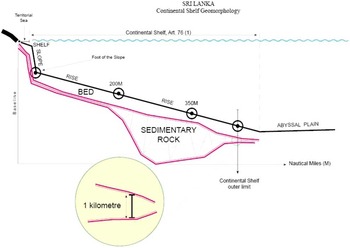
Having recited the main “special characteristics” that would give rise to “inequity”, were a coastal state to become subject to the constraints imposed by Article 76, the SoU nullifies those constraints and prescribes a specific method, including a specific constraint for establishing the limits of Sri Lanka's submerged landmass. It does so in terms of points on its continental margin (continental shelf) where the thickness of the sedimentary rock is not less than 1 km. In order to qualify for use of the alternative method prescribed by the SoU, Sri Lanka must first demonstrate to the CLCS the existence of four “special characteristics”: (a) the average distance at which the 200 metre isobath occurs is not less than 20 nautical miles; (b) the greater proportion of the sedimentary rock of the continental margin lies beneath the rise; (c) the mathematical average of the thickness of sedimentary rock along a line established at the maximum distance permissible in accordance with the provisions of paragraph 4(a)(i) and (ii) of Article 76 as representing the entire outer edge of the continental margin would not be less than 3.5 km; and (d) that more than half of the margin would be excluded by the application of such a line.Footnote 18
Incorporation by reference of the SoU in Annex II to the ConventionFootnote 19 thereby makes the SoU part and parcel of the Convention itself, confers upon it legally binding force, and requires that its interpretation be in accordance with the Vienna Convention on the Law of Treaties.
IV. Interpreting The Statement of Understanding
A. Substitution of Constraints
Upon demonstration of the existence of the aforementioned four special characteristics, the Conference authorized recognition that Sri Lanka may, “notwithstanding the provisions of Article 76”, apply the specific method prescribed in the third paragraph of the SoU. Additionally, Sri Lanka was authorized to: “Establish the outer edge of its continental margin by straight lines not exceeding 60 nautical miles in length connecting fixed points, defined by latitude and longitude, at each of which the thickness of sedimentary rock is not less than 1 kilometre.”Footnote 20
The SoU achieves the release of Sri Lanka from application of the constraints provided for in Article 76 by use of the phrase “notwithstanding the provisions of Article 76”, the equivalent of the Latin non obstante, applied in European legal drafting since the fifteenth century, to mean the removal of existing legal constraints.Footnote 21 When applied without qualification or circumscription of any kind, as referred to in the paragraph of the SoU, the ordinary meaning of the phrase “notwithstanding the provisions of Article 76”, necessarily calls for exemption from all of the rules and related constraints provided for in that Article that are inconsistent with the provisions of the SoU, while substituting its own specific method and constraint on extension, viz., the 1 kilometre isopach.Footnote 22 The ordinary meaning of the phrase could not be understood in any sense other than excluding any and all of the constraints provided for in Article 76 that are inconsistent with the terms as well as the object and purpose of the exemption that was deemed necessary, in the opinion of the Conference, to enable Sri Lanka to reach the 1 kilometre isopach, and thus to redress the inequity that would result to Sri Lanka from the application of the constraints imposed by Article 76.
B. The Commission's Guideline 8.1.12
In its Guidelines,Footnote 23 the Commission makes reference to the SoU twice: in Guideline 8.1.12, and in Guideline 9.1.2 when merely quoting from the text of Annex II to the Convention.Footnote 24 In Guideline 8.1.12, the Commission “[a]cknowledges that, for the coastal States in the southern part of the Bay of Bengal, an exception to the provisions of paragraph 4 [of Article 76] is provided for by the Statement of Understanding …”.
While the Commission's observation in Guideline 8.1.12 is factually correct, it is open to misinterpretation, in that it may be taken to mean that what the rule characterizes as an “exception” was provided for by the SoU in order to exempt Sri Lanka only from applying the methods for establishing the continental shelf provided for in paragraph 4, thus leaving operative the constraints provided for in paragraph 5. However, it is clear that use of the phrase “notwithstanding the provisions of Article 76” can only mean that the Conference intended thereby to exempt Sri Lanka from all of the provisions of Article 76 that were inconsistent with the SoU. In particular, the constraints in paragraph 5 of the Article, in substitution for which the SoU provides its own constraint: the 1 kilometre isopach that Sri Lanka and India must apply. Guideline 8.1.12 is also open to the misinterpretation that any of “the coastal States in the southern part of the Bay of Bengal” may benefit from the provisions of the SoU, whereas it was clear that the only beneficiaries were to be Sri Lanka and India, referred to under the SoU as “these States in the southern part of the Bay of Bengal” (emphasis added).Footnote 25
It has been suggested that, by failing to take issue immediately with Guideline 8.1.12 as being misleading, Sri Lanka might be presumed to have agreed that all the provisions of Article 76 other than its paragraph 4, and including the constraints in its paragraph 5, were applicable to it. Such a presumption is untenable. As has been authoritatively and consistently stated: “Since sovereignty and independence of States constitute the cardinal rule of international law, ‘restrictions upon the independence of States cannot … be presumed’.”Footnote 26
C. The Unnamed Beneficiaries of the SoU in the Southern Part of the Bay of Bengal
The exemptions provided for in the SoU are to apply to matters related to the establishment of the outer edge of the continental margins of “these States in the southern part of the Bay of Bengal”. Questions have arisen as to: (1) whether the exemptions may be availed of by any “States in the southern part of the Bay of Bengal”; and (2) the definition of the “southern part” of the Bay of Bengal. As to the first question, the SoU is careful to refer to the margins of “these” states, implying that some defining criteria have already been enumerated either by objective defining characteristics (e.g. the four “special characteristics”); or that only Sri Lanka and India are meant,Footnote 27 since they were the only states discussed at the Conference in this context. The latter interpretation seems more plausible. It was never contemplated that the SoU could be used by any state in the southern part of the Bay of Bengal. As to the meaning of “southern part of the Bay of Bengal”, many geographical definitions are to be found, but it may not be necessary to actually define the area for the purpose of Sri Lanka's submission, since Sri Lanka is clearly a beneficiary of the SoU as a state located in the southern part of the Bay of Bengal.
On the other hand, it should also be made clear that while Sri Lanka is unquestionably one of “these States in the southern part of the Bay of Bengal”, its continental shelf—i.e. the natural prolongation of its land territory under the sea—extends in every geographical direction to the limits of its legal entitlement.Footnote 28
D. The Meaning of the Term “Continental Shelf” in the Convention
The UN Convention on the Law of the Sea is sometimes interpreted as treating as separate and distinct the concepts “continental shelf” and “continental margin”. This has given rise to a number of questions. For example, paragraph 1 of Article 77 recognizes a coastal state's “sovereign rights” over the “continental shelf for the purpose of exploring it and exploiting its natural resources”. The term “continental margin” does not appear. Paragraph 1 of Article 76 prescribes 200 nautical miles from the territorial sea baselines as the limit of the “continental shelf”, appearing to ignore the area of “margin” extending beyond it.
On the other hand, paragraph 4 of Article 76 deals with the delimitation and delineation of the “continental margin”. It makes no reference to the “continental shelf”. Does this denote a distinction between the limits of the two concepts? Paragraph 5 of Article 76 mentions only the “continental shelf” in order to specify its limits, but no mention is made of the “continental margin”. Should this be understood to mean that the constraints apply to the continental shelf only and have no bearing on the extent of the “margin”?
Confusion of the concepts “shelf” and “margin” may persist among those who deal normally with scientific treatises. However, the Convention is not a scientific treatise but the text of an agreement that has been carefully negotiated and is legally binding. Accordingly, the term “continental shelf” wherever it occurs in the Convention can only have the meaning given to it by the agreed definition set out in the first sentence of Article 76: “The continental shelf of a coastal state comprises the sea-bed and subsoil of the submarine areas that extend beyond its territorial sea throughout the natural prolongation of its land territory to the outer edge of the continental margin.”
The phrase “throughout the natural prolongation of its land territory” thus subsumes the geomorphic elements of shelf, slope, and rise, as made plain by paragraph 3 of Article 76, which also declares that this legal concept of the continental shelf “does not include the deep ocean floor with its oceanic ridges or the subsoil thereof”.
The Convention thus establishes, as a rule of interpretation, that the term “continental shelf” in Article 76(1) (and whenever used in the Convention) is used to describe a juridical concept and not the geomorphic concept that might come to mind upon reading this term in a treatise on geology. Fortunately, the late Vincent McKelvey of the US, one of the most distinguished geologists to participate in the Conference, helped elucidate the meaning of the term “continental shelf” as used in the Convention:
Although Article 76 is entitled “Definition of the Continental Shelf”, it uses that term as a special juridical term applying to whatever part of the sea-bottom falls under national jurisdiction in the regime it describes. Geologists both inside and outside the Conference have done their best to have the term used only in the geomorphic sense (see Figure 1), but to no avail, mainly because the term was used in the same juridical sense in the 1958 Geneva Convention on the Continental Shelf, the thrust of which, the lawyers and diplomats believe would be weakened if the term were used in its more restricted geomorphic sense. Be that as it may, the meaning of the term “continental shelf’ is clarified within the text of Article 76. Paragraph 1 of Article 76 states that “the continental shelf of a coastal State comprises the seabed and subsoil of the submarine areas that extend beyond its territorial sea throughout the natural prolongation of its land territory to the outer edge of the continental margin”, and paragraph 3 says that “the continental margin … consists of the shelf, the slope, and the rise’, using these terms in their conventional geomorphic senses. Paragraph 3 goes on to say that the continental margin “does not include the deep-ocean floor with its oceanic ridges or the subsoil thereof”, but such features are clearly meant in paragraph 1 to be a part of a coastal State's continental shelf “where the outer edge of the continental margin does not extend … to a distance of 200 nautical miles from the baselines from which the breadth of the territorial sea is measured”. Sovereign rights over sea-bottom resources would also be given to the coastal State under the 200-mile exclusive economic zone described in Articles 56 and 57 of the Convention. Even though its inclusion in paragraph 1 may thus seem redundant, it serves to emphasize further that the term continental shelf as used in the draft Convention is a juridical and not a geomorphic term.Footnote 29
E. The Constraints Provided for in Paragraph 5 of Article 76 Do Not Apply to Sri Lanka
The constraints specified in paragraph 5 of Article 76 do not, and could not have been intended to, apply to Sri Lanka.Footnote 30 Delimitation of Sri Lanka's continental shelf is to be governed by the provisions of the SoU, and any provision in Article 76 that is inconsistent with the SoU, e.g. the method of establishing the continental margin and the constraints in paragraph 5 of the Article, do not apply to Sri Lanka for the following reasons.
First, the text of paragraph 5 contains no wording that would empower it with respect to Sri Lanka's continental shelf as governed by the SoU, which was adopted after the adoption of Article 76, and did not lead to amendment of any previously adopted text.
Second, the text of the SoU categorically disconnects any provisions of Article 76 that could control the implementation of the SoU. This is established by: (1) the use of the phrase “notwithstanding the provisions of Article 76” in the third paragraph of the SoU; and (2) substituting for the choice of methods offered by paragraph 4 and the choice of constraints offered by paragraph 5, the application of a single specific method and single constraint specific to Sri Lanka's geomorphic characteristics, i.e. the 1 kilometre isopach, as demarcated by lines no more than 60 nautical miles in length.
Third, it would also be noted that application of the constraints in paragraph 5 of Article 76 is made dependent on the application of paragraph 4, whereas CLCS Guideline 8.1.12 itself concedes that Sri Lanka is exempt from the application of paragraph 4.
Fourth, to argue that Article 76(5) constraints apply to Sri Lanka is to assume that Sri Lanka, which is already subject to its specific constraint under the SoU, should be subjected to additional constraints from Article 76, whereas the object and purpose of the SoU was, and remains, the lifting of Article 76 constraints so as to redress an inequity recognized by the entire Conference in 1980.
Fifth, nor are the consequences at all clear of attempting to apply to Sri Lanka, for example the 350 nautical mile constraint from Article 76(5). Application could mean either that Sri Lanka's continental shelf could be reduced, ending landward of the 1 km isopach; or if the 350 nautical mile line were to be placed beyond or seaward of the 1 km isopach, that the shelf would be enlarged.
But the legal force of the SoU, being itself part of the Convention, is the same as that of Article 76(5), so that the two provisions would contradict each other. If the 350 nautical mile constraint reduces the area of the shelf, Sri Lanka could claim that it is inoperative as the context of Article 76(5) was changed by the SoU, being a “subsequent agreement between the parties regarding the interpretation of the treaty or the application of its provisions”,Footnote 31 or even an “agreement relating to the Treaty which was made between all the parties in connection with the conclusion of the Treaty”.Footnote 32 If, on the other hand, the 350 nautical mile constraint ends beyond or seaward of the 1 km isopach, it would be irrelevant, since Sri Lanka would be bound by the 1 km isopach limit specified in paragraph 3 of the SoU.
V. Conclusion
While it must have been clear to every state at the Conference that the “specific method to be used in establishing the outer edge of the continental margin” was proposed and negotiated by Sri Lanka, and ultimately granted to Sri Lanka and India, being “these States in the southern part of the Bay of Bengal”, other states with similar geomorphic characteristics could seek to take advantage of elements of the SoU, such as the removal of Article 76 constraints. While any such intention by another state need not be a matter for concern or comment, problems could arise for the two unnamed beneficiaries (definitively identified during the Conference as Sri Lanka and India) of the SoU if there were to be an interpretation and/or application of SoU in regard to a third state without the benefit of a prior full-scale consideration of the terms of the SoU in relation to the two (and only two) acknowledged beneficiaries.
As it is evident that Sri Lanka and India are not among the states whose submissions to the CLCS are likely to be taken up in the near future, it would be open to them to make a formal statement which would recall that the “specific method” set forth in the SoU was granted by the Conference to Sri Lanka and India. Furthermore, the Commission will have to be invited “to be governed” by the terms of the SoU when making its recommendations with respect to the continental margins of these two states. Even as between them, India has expressed its preference that the submission of Sri Lanka be considered before that of India.
Such a statement should call attention to the complexities involved in considering any submission by a third state, to the extent that it is based on the SoU, before reaching conclusions on the submissions thereunder by Sri Lanka and India, as well as the risk of reaching an inequitable result by doing so. It may also be an issue for consideration whether the interpretation and application of the SoU to the submission of a state other than the two unnamed but generally recognized beneficiaries of the SoU, and any recommendation based thereon, would be legally admissible.
ANNEX A
Article 76, United Nations Convention on the Law of the Sea
Article 76
Definition of the continental shelf
1. The continental shelf of a coastal State comprises the seabed and subsoil of the submarine areas that extend beyond its territorial sea throughout the natural prolongation of its land territory to the outer edge of the continental margin, or to a distance of 200 nautical miles from the baselines from which the breadth of the territorial sea is measured where the outer edge of the continental margin does not extend up to that distance.
2. The continental shelf of a coastal State shall not extend beyond the limits provided for in paragraphs 4 to 6.
3. The continental margin comprises the submerged prolongation of the land mass of the coastal State, and consists of the seabed and subsoil of the shelf, the slope and the rise. It does not include the deep ocean floor with its oceanic ridges or the subsoil thereof.
4. (a) For the purposes of this Convention, the coastal State shall establish the outer edge of the continental margin wherever the margin extends beyond 200 nautical miles from the baselines from which the breadth of the territorial sea is measured, by either:
(i) a line delineated in accordance with paragraph 7 by reference to the outermost fixed points at each of which the thickness of sedimentary rocks is at least 1 per cent of the shortest distance from such point to the foot of the continental slope; or
(ii) a line delineated in accordance with paragraph 7 by reference to fixed points not more than 60 nautical miles from the foot of the continental slope
(b) In the absence of evidence to the contrary, the foot of the continental slope shall be determined as the point of maximum change in the gradient at its base.
5. The fixed points comprising the line of the outer limits of the continental shelf on the seabed, drawn in accordance with paragraph 4 (a)(i) and (ii), either shall not exceed 350 nautical miles from the baselines from which the breadth of the territorial sea is measured or shall not exceed 100 nautical miles from the 2,500 metre isobath, which is a line connecting the depth of 2,500 metres.
6. Notwithstanding the provisions of paragraph 5, on submarine ridges, the outer limit of the continental shelf shall not exceed 350 nautical miles from the baselines from which the breadth of the territorial sea is measured. This paragraph does not apply to submarine elevations that are natural components of the continental margin, such as its plateaux, rises, caps, banks and spurs.
7. The coastal State shall delineate the outer limits of its continental shelf, where that shelf extends beyond 200 nautical miles from the baselines from which the breadth of the territorial sea is measured, by straight lines not exceeding 60 nautical miles in length, connecting fixed points, defined by coordinates of latitude and longitude.
8. Information on the limits of the continental shelf beyond 200 nautical miles from the baselines from which the breadth of the territorial sea is measured shall be submitted by the coastal State to the Commission on the Limits of the Continental Shelf set up under Annex II on the basis of equitable geographical representation. The Commission shall make recommendations to coastal States on matters related to the establishment of the outer limits of their continental shelf. The limits of the shelf established by a coastal State on the basis of these recommendations shall be final and binding.
9. The coastal State shall deposit with the Secretary-General of the United Nations charts and relevant information, including geodetic data, permanently describing the outer limits of its continental shelf. The Secretary-General shall give due publicity thereto.
10. The provisions of this article are without prejudice to the question of delimitation of the continental shelf between States with opposite or adjacent coasts.
ANNEX B
Annex II, Final Act, The Third United Nations Conference on the Law of the Sea
Statement of understanding concerning a specific method to be used in establishing the outer edge of the continental margin
The Third United Nations Conference on the Law of the Sea,
Considering the special characteristics of a State's continental margin where: (1) the average distance at which the 200 metre isobath occurs is not more than 20 nautical miles; (2) the greater proportion of the sedimentary rock of the continental margin lies beneath the rise, and
Taking into account the inequity that would result to that State from the application to its continental margin of article 76 of the Convention, in that, the mathematical average of the thickness of sedimentary rock along a line established at the maximum distance permissible in accordance with the provisions of paragraph 4 (a) (i) and (ii) of that article as representing the entire outer edge of the continental margin would not be less than 3.5 kilometres, and that more than half of the margin would be excluded thereby,
Recognizes that such State may, notwithstanding the provisions of article 76, establish the outer edge of its continental margin by straight lines not exceeding 60 nautical miles in length connecting fixed points, defined by latitude and longitude, at each of which the thickness of sedimentary rock is not less than 1 kilometre;
Where a State establishes the outer edge of its continental margin by applying the method set forth in the preceding paragraph of this statement, this method may also be utilized by a neighbouring State for delineating the outer edge of its continental margin on a common geological feature, where its outer edge would lie on such feature on a line established at the maximum distance permissible in accordance with article 76, paragraph 4 (a) (i) and (ii), along which the mathematical average of the thickness of sedimentary rock is not less than 3.5 kilometres;
The Conference Requests the Commission on the Limits of the Continental Shelf set up pursuant to Annex II of the Convention, to be governed by the terms of this Statement when making its recommendations on matters related to the establishment of the outer edge of the continental margins of these States in the southern part of the Bay of Bengal.
ANNEX C
Diagram of outer limit authorized by Article 76.

Diagram of outer limit recognized for Sri Lanka/India by the Statement of Understanding (Annex B).

ANNEX D
Sri Lanka Aide Memoire, April 1979

Source: IV Third United Nations Conference on the Law of the Sea: Documents, compiled and edited by R. Platzöder (Ser.1) 514–515 (Oceana Publications).
ANNEX E
Diagram representations of the continental shelf
Source E1: V.E. MCKELVEY, “Interpretation of the UNCLOS III Definition of the Continental Shelf”, in D.M. JOHNSTON and N.G. LETALIK, eds., The Law of the Sea and Ocean Industry: New Opportunities and Restraints (Hawaii: Law of the Sea Institute, 1982), 465−7.

Source E2: Division of Ocean Affairs and the Law of the Sea, Office of Legal Affairs, Definition of the Continental Shelf UN Sales No. E.93.V.19 (1993), 18 and 19.