Introduction
The soils of Continental Antarctica are at the extreme end of the ‘soil’ spectrum. Evidence of pedogenic processes, such as desert pavement formation, salt redistribution, in situ weathering of clasts, staining by iron oxides, increasing soil coherence and increasing depth of ice/ice-cemented permafrost with soil age, are found throughout Antarctica. This evidence enables differentiation of soils from the initial unconsolidated mineral deposit, and supports the inclusion of Antarctic soils in the US Department of Agriculture (USDA) soil classification (Ugolini & Bockheim Reference Ugolini and Bockheim2008).
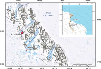
Systematic characterization of soils in the Ross Sea region of Antarctica has recently been advanced as part of multidisciplinary science campaigns targeting strategic sites along a latitudinal gradient within the Latitudinal Gradient Project (LGP; Howard-Williams et al. Reference Howard-Williams, Peterson, Lyons, Cattaneo-Vietti and Gordon2006) and by a reconnaissance soil survey that uses the taxonomy of Gelisols (Soil Survey Staff 2010) as a basis for defining map units (McLeod et al. Reference McLeod, Bockheim, Balks and Aislabie2009). The great majority of ice-free areas with soil cover occur in the Transantarctic Mountains, which constitute the division between West Antarctica and East Antarctica. At roughly 3500 km long, the Transantarctic Mountains are one of the longest mountain ranges on Earth, extending from Cape Adare, along the Ross Sea/Ice Shelf coast and into the Weddell Sea region. Most of the detailed soil characterization and soil survey in the Ross Sea region has been in the area of the McMurdo Dry Valleys in the northern Transantarctic Mountains at c. 77°S. The Central Transantarctic Mountains (CTAM) adjacent to the Beardmore Glacier, an outlet glacier of the East Antarctic Ice Sheet draining ice from the polar plateau to the Ross Ice Shelf, remain less comprehensively studied. Although largely covered in ice, the CTAM region contains several ice-free areas of up to 10 000 ha, consisting of either bare rock mountaintops and nunataks or glacial deposits comprising drift sheets and moraines. This paper reports the properties and distributions of soils in three ice-free areas in the CTAM (Fig. 1). The work extends the characterization of soils to the southern-most part of the latitudinal gradient of the LGP.
Map of Central Transantarctic Mountain (CTAM) region with study sites located at Dominion Range, Mount Achernar and Ong Valley. Green triangle indicates position of CTAM base camp.

The majority of soils in the CTAM region are formed in glacial deposits. Glacial activity is the major driver of landscape evolution on the Antarctic continent (Campbell & Claridge Reference Campbell and Claridge1987). In situ soil formation (i.e. soils forming directly in bedrock) is generally limited to higher altitudes or steep slopes where the bedrock is exposed.
Antarctic soils are commonly evaluated in terms of weathering stages (Campbell & Claridge Reference Campbell and Claridge1975) and associated morphogenetic salt stages (Bockheim Reference Bockheim1997; Table I). The approximate ages assigned to the salt stages are based on age constraints of landform units in the McMurdo Dry Valleys region; extrapolation of these ages to other regions assumes a similar rate of salt deposition and accumulation, which are dependent on local climatic factors.
Weathering stages (Campbell & Claridge Reference Campbell and Claridge1975) and salt stages (after Bockheim Reference Bockheim1997).

Previous soil work in the Beardmore Glacier region has largely focused on correlating drift sheets along the Transantarctic Mountains for reconstructing past glacier and ice sheet limits (Denton et al. Reference Denton, Bockheim, Wilson and Leide1989a, Reference Denton, Bockheim, Wilson and Stuiver1989b). Several major drift units, corresponding to different stages of glacier thickening due to ice grounding in the Ross Sea, and plateau ice level fluctuations have been recognized and described throughout the CTAM area (Table II).
Summary of major glacial drift units associated with the Beardmore Glacier.

WS=weathering stage, SS=salt stage.
*Denton et al. Reference Denton, Bockheim, Wilson and Leide1989a, †Bockheim Reference Bockheim1990.
Soil data from Denton et al. (Reference Denton, Bockheim, Wilson and Leide1989a) has been incorporated into a broader study of soil development in the greater Transantarctic Mountain region (Bockheim Reference Bockheim1990). Denton et al. (Reference Denton, Bockheim, Wilson and Leide1989a) described soils in the Meyer Desert, c. 25 km to the north-east of our study site at the Dominion Range, where Plunket drift flanks Beardmore Glacier across the entire western Dominion Range. The soils reached the maximum salt and weathering stage 3 within the older Meyer drift, indicating soil development of an intermediate stage and an age of c. 90–250 ka based on correlation with numerically dated drifts in locations further north. Soils in the Meyer Desert ranged from 14 cm (Plunket drift) to 82 cm (Meyer drift) of soil material over ice, with the presence of ghosts (clasts weathered in situ within the soil profile) being a feature nearly exclusive to soils of the Meyer drift.
Claridge & Campbell (Reference Claridge and Campbell1968) described a range of soils in the Shackleton Glacier region (south of the Beardmore Glacier). The extreme aridity was cited as a major determinant of soil development. The soils were formed under similar conditions to those in the Beardmore Glacier region, in a variety of parent materials, including scree slopes and in situ bedrock, and covered landscapes of a wide (inferred) exposure age range. Strongly developed soils on the Roberts Massif, at elevations > 300 m above present ice level, exhibited weathering characteristics indicative of millions of years of development. Weakly developed, thin, unconsolidated soils were common in deposits closer to current ice level, with much less salt accumulation evident.
Our study contributes to the LGP, which posed the question: to what extent does soil development (e.g. degree of weathering, carbon content and nutrient accumulation) change with latitude and, therefore, influence terrestrial ecosystems? (Howard-Williams et al. Reference Howard-Williams, Peterson, Lyons, Cattaneo-Vietti and Gordon2006). The objective of the study was to undertake reconnaissance-level mapping and characterization of soils at selected sites in the Beardmore Glacier region of the Transantarctic Mountains. This southernmost coverage complements and contrasts previous LGP work conducted at Cape Hallet (Hofstee et al. Reference Hofstee, Balks, Petchey and Campbell2006) and in the Darwin Glacier region (Aislabie et al. Reference Aislabie, Bockheim, McLeod, Hunter, Stevenson and Barker2012). Furthermore, this study investigates chronosequences at a finer scale than previous work. Differences within a landscape unit, treated in previous studies as a homogeneous drift (Denton et al. Reference Denton, Bockheim, Wilson and Leide1989a, Reference Denton, Bockheim, Wilson and Stuiver1989b, Bockheim Reference Bockheim1990), are described.
Methods
Landform units were initially delineated using a combination of satellite imagery, aerial photographs, topographical and geological maps, and observation from helicopter. The preliminary units were used to target soil investigation. Soil pits were excavated to a maximum practicable depth (generally limited by the presence of massive/glacial ice and no greater than 1 m) within an area observed to be representative of the greater landscape unit or representative of part of a gradient within a soil-landscape unit. Where patterned ground was present, the pits were dug in the centre of polygons. Soil descriptions of the pit face (profile) followed standard practice as described in Schoeneberger et al. (Reference Schoeneberger, Wysocki, Benham and Broderson2002), and soil classification followed USDA soil taxonomy (Soil Survey Staff 2010). Soil maps were constructed using the soil and landscape descriptions. Soils were sampled as per described horizons. Approximately 0.5 kg of soil material per horizon was transported to New Zealand in sealed plastic bags. Soil samples were pre-sieved (<2 mm) in the field and all analyses were conducted on the <2 mm fraction.
Particle size analysis was performed on a laser sizer (Malvern Mastersizer 2000), after H2O2 digestion and dispersion with Calgon. Particle size classes were defined as: sand (63–2000 μm), silt (3.9–63 μm) and clay (0.06–3.9 μm). Analyses were conducted at the Landcare Research Environmental Chemistry Laboratory (Palmerston North, New Zealand) using methods described in McLeod et al. (Reference McLeod, Bockheim, Balks and Aislabie2009). Gravimetric moisture content was measured by calculating mass loss after drying subsamples to constant weight at 105°C. Total carbon and nitrogen values were obtained by combusting a subsample with pure O2 at 1050°C in a Leco CNS-2000 analyser. Soil pH was measured on a 1:2.5 soil:water suspension. Water-soluble cations were measured via flame atomic absorption spectrophotometry with an air-acetylene flame and anions were measured via ion chromatography. A temperature compensated probe was used to measure electrical conductivity on a 1:5 soil:water mixture.
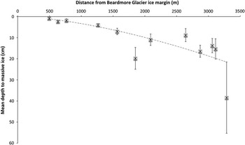
Depth to massive ice was investigated along a 3.5 km transect from ice edge through the lateral moraine suite at the Dominion Range site. At twelve sites along the transect, thirty measurements (1 m apart) were taken by probing through the soil with a fiberglass rod. The depth of soil was recorded and the mean depth calculated from the thirty measurements per site.
Topographical and geological setting
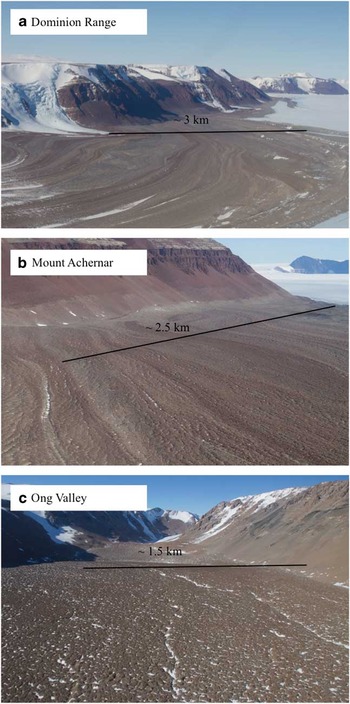
Situated between the head of the Beardmore and Nimrod glaciers, the Dominion Range has a broad (c. 4 km wide) sweep of lateral moraine adjacent to its western margin (Fig. 2a). The lateral moraines are characterized by a strong curvilinear pattern of alternating red and grey ridges, corresponding to differing lithologies dominating the moraine surfaces, separated by shallow swales, forming a landscape unit with up to 6 m of relief. The influence of smaller alpine glaciers flowing down off the Dominion Range plateau is evident as a series of terminal moraines on the ice-distal limit of the lateral moraines. On the edge of the polar plateau, ice level is 2200 m above sea level (a.s.l.), with minimal altitude variation (c. 50 m) across the moraine suite. Local geology is dominated by Ferrar Dolerite and Buckley Formation sedimentary rocks (including shale, sandstone, coal and glossopterid fossils; Elliot et al. Reference Elliot, Barrett and Mayewski1974).
Landscapes of the main study sites. a. Dominion Range looking south-east. b. Mount Achernar looking north-west. c. Ong Valley looking to the head of the valley. Photographs: Errol Balks.

Mount Achernar is bounded to the north by the Law Glacier, with a 6–10 km -wide expanse of lateral moraine deposits at the eastern foot (Fig. 2b). A banding pattern, similar to that at the Dominion Range, is evident in the Law Glacier lateral moraines and the influence of several smaller glaciers from the south is also observed. The moraines lie between 1800–1900 m a.s.l. The Mount Achernar bluffs adjacent to the moraine suite are comprised of Ferrar Dolerite and Buckley Formation sediments, with Fremouw Formation sedimentary rocks (sandstones and mudstones, some shale) prevalent nearby (Barrett & Elliot Reference Barrett and Elliot1973).
Ong Valley is a narrow (c. 2 km at the widest), ice-free valley c. 8 km long (Fig. 2c). The steep valley walls are primarily composed of the Hope Granite (Barrett et al. Reference Barrett, Lindsay and Gunner1970) frequently mantled with scree. The valley floor is covered with glacial deposits of mixed geology emplaced by the Argosy Glacier that has advanced up from the mouth of valley in the past. A smaller unnamed glacier intrudes into the head of the Ong Valley, and evidence of greater previous extent of this glacier is observable. The ice level (Argosy Glacier) at the mouth of the valley is c. 1500 m a.s.l. and the valley floor rises to c. 1700 m at its head.
Surface ages
Glacial deposits examined in the Dominion Range and Mount Achernar sites correlate to the Plunket and Beardmore drifts (Table I) as described by Denton et al. (Reference Denton, Bockheim, Wilson and Leide1989a), with an estimated maximum age of 23.8 ka (Bockheim Reference Bockheim1990). However, cosmogenic exposure age dating of quartz-bearing rocks suggests that the moraines at Mount Achernar are much older at 300–500 ka (Faure & Nishiizumi unpublished, Mathieson et al. unpublished).
Climate
Few climate data are available for the region. Field observations (21/12/2010–13/01/2011) suggest a scarcity of liquid water; no evidence of melt/liquid moisture was observed, with the exception of margins of snow patches following recent snowfalls that sublimated within a day. At the three study sites, air temperatures above 0°C were never measured. Positive soil surface temperatures (maximum recorded surface temperature of +2°C) were rarely encountered. Summer air temperatures (recorded at the CTAM base camp on the Walcott Neve, taken as an approximation of air temperatures for the wider region) indicated that our field studies were conducted at the peak of the summer period. Therefore, temperatures higher than those observed (and by extension, presence of liquid water) are improbable at other times of the year. Mean annual temperature estimated at -39.4°C and mean annual (water) accumulation of 36 mm have been inferred from unpublished snow pit data (Beardmore South Camp, 84°03'S, 164°15'E; Bockheim Reference Bockheim1990).
Precipitation during the study period was rare and light. ‘New’ snow did not persist on the ground for more than 48 hours, although persistent snow patches were observed in patterned ground cracks throughout the area. The soils (and climate) in the study area were classed as ultraxerous (Claridge & Campbell Reference Claridge and Campbell1968).
Organisms
Evidence of any higher organisms (e.g. lichens, mosses, Collembolla, etc.) was lacking at all sites studied. Microbial life is present, although at low abundance/biomass (Scarrow Reference Scarrow2013).
Results
Soil distribution in the landscape
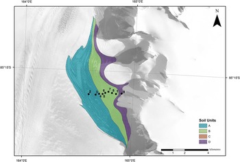
The soil maps for the Dominion Range and Mount Achernar sites (Figs 3 & 4) reflect a succession of ages of drift within the lateral moraine belt. Soils vary from shallow and weakly developed adjacent to the glacier, to deeper and more developed at increasing distance from the glacier (Table ST1 found at http://dx.doi.org/10.1017/S0954102014000078).
Soil map of Dominion Range. Pit locations marked by numbers.

Soil map of Mount Achernar. Pit locations marked by numbers.

Soil unit A is the zone of soil directly adjacent to the glacier. Unit A had the highest relief, in the form of ice flow-parallel ridges up to 6 m high and 30 m wide. Soils of unit A had up to 10 cm of till over massive ice. There was no horizon differentiation except for the presence of a vesicular surface crust in some places. Distribution of the vesicular crust was patchy and had no apparent relationship with the wider landscape. Soils were lithochromic, with no oxidation evident. Clasts within the soils were generally unstained, fresh and angular to sub-angular. Unit A soils were classified as a complex of Glacic Haplorthels and Glacic Haploturbels. We mapped a compound unit including Turbels, despite a lack of evidence for cryoturbation in individual soil profiles, because of the presence of hummocky, thermokarst topography and weakly developed patterned ground.
Unit B soils had 10–30 cm of till over massive/glacial ice. The soils of unit B were also classified as a complex of Glacic Haplorthels and Glacic Haploturbels. At least two horizons could be differentiated within unit B soil profiles, on a colour and/or texture basis (generally more cohesion and a yellower colour in the surface horizon). A vesicular surface crust was generally present (although not always) in a spatially patchy distribution irrespective of other landscape features, the thickness of the crust varied from 0.5–6 cm. Surface topography within unit B was more regular than unit A, with high centred polygons (0.5–1 m high), and multiple generations of cross-cutting tension cracks distinguishable in some instances. The polygonal network of cracks formed by thermal expansion and contraction of glacial ice suggests ice flow is limited and provides minimal disruption to ongoing soil and landscape development.
Soils of unit C (identified only at the Mount Achernar site) were considerably deeper than units A and B, with massive ice found no shallower than 60 cm from the surface. Soils were classified as either Glacic Haploturbels or Anhyturbels, with one Typic Anhyturbel (with no massive ice or ice-cement within 100 cm of the surface). Soil development was more pronounced in unit C, relative to units A and B, with stronger horizonation in all profiles. A vesicular surface crust was present in all unit C profiles, and oxidation of materials lower in the profile was discernable. Strongly developed patterned ground defined the topography of unit C, with polygons 1–2 m high a near ubiquitous surface feature.
Unit D soils were recognized as discrete from the chronosequence comprising units A through C, as they have formed in the terminal moraine deposits of the alpine glaciers. Soils of unit D exhibit similar extents of soil development (e.g. horizonation) and patterned ground evolution as unit C, and are thus considered to be of similar age.
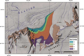
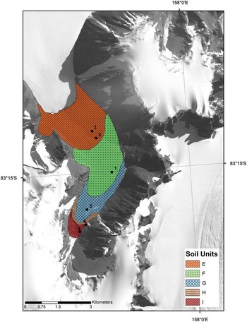
At Ong Valley a soil chronosequence similar to that at the Dominion Range and Mount Achernar sites was observed, with soil units E through to G (Fig. 5) increasing in age and development with distance from the Argossy Glacier. Unit H is distinct from the sequence, comprising soils formed in colluvial material rather than glacial deposits.
Soil map of Ong Valley. Pit locations marked by numbers.

Unit E soils had massive ice no deeper than 50 cm underlying the soil profile. Horizonation was minimal, with a crusty surface layer being the most obvious feature. Soils within unit E were classified as a complex of Glacic Haplorthels and Glacic Haploturbels. Topography within unit E ranged from large hummocky, thermokarst features through to weakly developed patterned ground, with polygons of variable size and height.
The soils in unit F had no massive ice within 70 cm of the surface. Two subsurface horizons were distinguishable on a soil consistence basis; upper horizons generally being more cohesive. Unit F contained a complex of Glacic Anhyorthels and Glacic Anhyturbels. High (1–2 m) centred polygons, regularly 5–8 by 6–10 m across, were the dominant topographical features.
Unit G, relating to the furthest up-valley (i.e. oldest) drift, comprised soils in the Typic Anhyturbel/Anhyorthel subgroups, with no massive ice or ice-cement within 80 cm of the soil surface. Multiple horizons were discernible in both texture and consistency. Topography featured high-centred (1–1.5 m), six-sided polygons, 6–10 m across.
Unit H comprised a prominent terminal moraine c. 4 m high. A Typic Anhyorthel soil was observed within the distinct, narrow moraine ridge, with no evidence of cryoturbation, although colluvial effects were observed at the margins of the moraine crest. The lower c. 45 cm of the soil profile contained more large clasts (Table ST6 http://dx.doi.org/10.1017/S0954102014000078) than the subsoils in units E, F and G.
Unit I, at the head of Ong Valley, was outside the furthest (visible) extent of the Argosy Glacier. The profile was made up of an accumulation of fine gruss with a sandy matrix showing many millimetre-scale laminations in the top of the profile. A layer of weathered and stained clasts was observed at 45 cm depth. Patterned ground was absent, with maximum relief being 20–40 cm, corresponding to gentle swales within the flat valley fill. Massive ice was not observed within the upper 70 cm of the soil (the depth of excavation) and despite not reaching the 100 cm depth of exposure to make a definitive classification, this soil is probably a Typic Anhyorthel.
Chemical and physical soil properties
The chemical and physical properties for all sampled horizons are presented in Tables ST2, ST3 and ST4 found at http://dx.doi.org/10.1017/S0954102014000078.
Soil moisture in all sampled horizons was low (< 5%), well below the c. 10% threshold required for ice cementation of permafrost.
Soil pH for all horizons was moderately to extremely alkaline, ranging from 7.87–9.22. Soil pH generally decreased along the gradient from the current ice edge, this decrease being significant (P<0.05) in three of the five cases (Fig. ST1 http://dx.doi.org/10.1017/S0954102014000078).
None of the soils investigated had high salt contents (maximum electrical conductivity of 7.39 dS m-1 within the lower 10% of the salt stage scale, Table I), thus confirming observations assigning salt stages of 1 or 2. Salt content generally showed an increase with distance from the ice edge (Tables ST4, ST5 & ST6 http://dx.doi.org/10.1017/S0954102014000078). The anion component of the soil profile salts was generally dominated by sulphates (Tables ST2, ST3 & ST4 http://dx.doi.org/10.1017/S0954102014000078).
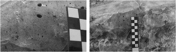
Carbon and nitrogen concentrations within all the soils studied were extremely low; generally well below 1%, pointing to the paucity of biomass within the soil (Scarrow Reference Scarrow2013). The total carbon measurements include contributions from carbonates, corroborated by the high pH levels (all>7). One feature of interest is the distinctly higher levels of carbon in the bottom of all Mount Achernar soils, relative to overlying soil layers. The carbon data parallel the field observations of darker colours in several of the bottom horizons. Dark clastic fragments were also present within the underlying ice (Fig. 7). Coal was present at the Mount Achernar site, both as a visible seam in the side of the mountain and as lumps scattered across the surface of the moraine field.
All soils sampled contained gravel and larger clasts. The grain size of the < 2 mm fraction of all soils was dominated by sand-sized particles (63–2000 µm; Tables ST2, ST3 & ST4 http://dx.doi.org/10.1017/S0954102014000078). Clay (0.06–3.9 µm) content was very low in most cases, with a maximum of 17.4%. The proportion of clays in the surface horizons exhibited a general decrease with increasing distance from the ice edge (Tables ST2, ST3 & ST4 http://dx.doi.org/10.1017/S0954102014000078). Larger clasts (e.g. cobbles and stones) were generally concentrated in the surface horizon (generally < 5 cm deep), with the bulk of underlying soil being relatively clast-poor (Tables ST5 & ST6 http://dx.doi.org/10.1017/S0954102014000078). Exceptions to this pattern occurred in soils distal to the current ice margin, where larger clasts were found throughout the soil profiles (Table ST5 http://dx.doi.org/10.1017/S0954102014000078). The surface of the terminal moraine unit at the Ong Valley site (unit H) was conspicuously lacking in larger clasts, relative to other soils examined.
Patterns of soil depth
The transect across the Dominion Range lateral moraines showed a general increase in depth to ice (i.e. amount of soil overlying ice) with distance from the Beardmore Glacier (Fig. 6). Although not quantified statistically, soils at the other sites generally showed the same trend. Observations at Mount Achernar (Fig. 7) revealed an amount of rock/mineral material within the underlying ice.
Depth to massive ice across the Dominion Range site, r 2 0.87. Vertical error bars are 1 standard deviation, n = 30 at each site.

Mineral material embedded in massive ice underlying soils at Mount Achernar.

Discussion
The soils described in this study exemplify, and are perhaps the most extreme example of, the statement: Antarctic soils are considered to be soils in which the biological factors are reduced to a minimum although they never quite reach zero (Claridge & Campbell Reference Claridge and Campbell1968). This is in direct contrast to the soils of Cape Hallet at the other end of the LGP, recognized as ‘Ornithogenic soils’ owing to the profound influence of local Adélie penguin populations (via guano, other organic matter additions and stone sorting activities) in a warmer, wetter, coastal environment (Hofstee et al. Reference Hofstee, Balks, Petchey and Campbell2006).
While the same overall soil development pattern was observed along a chronosequence at all three study sites (Mount Achernar, Dominion Range and Ong Valley), there were some important differences. Ong Valley differs from the other sites due to its topographical setting. The narrow valley has concentrated the flow of debris-laden ice and colluviual inputs from the valley walls have a greater influence. The major differences between the Mount Achernar and Dominion Range sites (e.g. no unit C at Dominion Range; Figs 3 & 4) are probably due to the amount of debris available to the ice flowing past the site. The polar plateau is the arbitrary source of ice flow towards the two sites; therefore, it is probable that less debris has accumulated in/on the ice by the time it reaches Dominion Range relative to Mount Achernar. Consequently, the amount of soil material is probably a function of the volume of material available ‘upstream’.
All the soils could be considered to be weakly developed, showing little in the way of staining, weathering of clasts or accumulation of salts. According to Bockheim (Reference Bockheim1997), the salt stages that were recognized imply soil ages of < 18 ka (stage 1) and between 18–90 ka (stage 2; Table I). The relatively low accumulation of salts (compared to other Antarctic soils) may be due to a short duration of exposure, or a lower salt influx in this region of very low precipitation. The alkaline pH found consistently throughout the soils may also be linked to low levels of sulphate and/or nitrate deposition/precipitation. Claridge & Campbell (Reference Claridge and Campbell1968) found that significant deposition of nitrate and sulphate salts led to soil acidification by formation of nitric and sulphuric acid. However, a subtle decrease in soil pH with distance from ice edge supports the soil development gradient, with ice-distal (i.e. older) soils being more acidic due to greater aerosol accumulation relative to ice-proximal soils. A similar pattern is seen in the cation and anion data (Tables ST2, ST3 & ST4 http://dx.doi.org/10.1017/S0954102014000078).
Our soil investigations in the Beardmore Glacier region of the CTAMs, specifically the high altitude, near-plateau sites, highlight the profound influence of climate on soil development. It must be noted that altitude is far more instrumental in this climatic effect than latitude, as has been previously reported (Bockheim Reference Bockheim2008). The lack of visual evidence of liquid water and soil moisture content <5% support an ultraxerous soil-formation climate (Tables ST4, ST5 & ST6 http://dx.doi.org/10.1017/S0954102014000078). Current temperature data preclude the persistence of liquid water, even at the height of summer. The occurrence of a vesicular surface crust is indicative of some moisture (Bockheim Reference Bockheim2010). We submit that the patchy occurrence of such a crust is due to spatial heterogeneity of snowmelt. The lack of any ice-cemented soil materials and extremely low soil moisture levels indicate that any moisture present (intermittently) at the surface has minimal impact on the underlying soil and its development.
Based on field designations of the weathering and salt stages (Table I), and supported by salt data (Tables ST4, ST5 & ST6 http://dx.doi.org/10.1017/S0954102014000078), the soils examined at our sites would be expected to be relatively young (i.e. < 24 000 years), if soil formation is assumed to proceed at a similar rate in the Beardmore region as in other, better characterized regions (e.g. McMurdo Dry Valleys). At the Mount Achernar site, the assumed young age is challenged by two separate estimates of moraine ages based on cosmogenic 10Be and 26Al accumulation in quartz-bearing rocks (Faure & Nishiizumi unpublished, Mathieson et al. unpublished). Both studies suggest the oldest moraines at Mount Achernar are 300–664 ka, and much of the moraine suite is proposed to have been in place over the past two glacial cycles, with only the most ice-proximal material being emplaced since the Last Glacial Maximum (Mathieson et al. unpublished). If the cosmogenic exposure ages from Mount Achernar are accepted, rather than the correlated ages obtained from more distant sites where climatic factors probably differ, then soil development in the upper Beardmore Glacier region must be slower, by at least an order of magnitude, than in other regions of Antarctica previously studied (and where the weathering/salt stages were formulated/calibrated). The cosmogenic nuclide exposure ages of the Darwin Mountains (the second-most southern site of the LGP) also point to landscapes being older than past soil development interpretations predict (Storey et al. Reference Storey, Fink, Hood, Joy, Shulmeister, Riger-Kusk and Stevens2010). The Darwin Mountains are at a lower altitude and are further north than our study sites but the climate is probably similar (i.e. xerous to ultraxerous). Our observations point to the Ong Valley and Dominion Range soils being of similar age to Mount Achernar soils (based on development/weathering and assuming minimal climatic differences between sites) although no cosmogenic data are available.
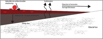
We present a model for soil formation/development at the recessional margins of cold-based glaciers near the polar plateau (Fig. 8). We propose that two main mechanisms contribute material to the developing soil at both the top and bottom of the profile. Weathering of supraglacial clasts provides materials for the upper layer of the soil, which thickens as boulders breakdown by thermally induced splitting, aeolian abrasion and spallation. Independently, the subsoil thickens by residual accumulation of englacial material as glacial ice sublimates. Thus the upper soil horizon thickens by an upbuilding process (Almond & Tonkin Reference Almond and Tonkin1999), while the subsoil thickens by lowering of the contact between soil and ice in an analogous way to deepening of soil by soil production into saprolite or rock (Heimsath et al. Reference Heimsath, Dietrich, Nishiizumi and Finkel1997, Humphreys & Wilkinson Reference Humphreys and Wilkinson2007).
Conceptual model of soil formation at recessional margins of cold-based glaciers.

Clast abundance data (Tables ST5 & ST6 http://dx.doi.org/10.1017/S0954102014000078) show a thin, clast-rich surface layer overlying a thick, relatively clast-poor subsoil. The clastic surface layer exhibits fairly constant thickness along the gradient from the current ice edge, whereas the underlying finer horizon thickens along the soil age/development gradient. This points to a finite contribution of material at the surface (e.g. the initial supraglacial debris load) and relatively slow coarse-clast comminution, while the subsoil receives continual additions from the underlying ice. The decrease in clay content of the upper horizon with increasing distance from the ice margin may represent increasing dilution of the clay fraction by added sand and silt. Alternatively, aeolian removal of clay particles may decrease clay content. The presence of larger clasts in lower horizons in the more ice-distal soil profiles is probably due to cryoturbation effects. At the ice-distal soil sites, larger clasts (e.g. boulders) were concentrated in or near to tension cracks relative to surrounding polygons. Alternatively, the escarpment on the glacier margin may be a source of coarse clastic material via rockfall.
The soil of unit I (Ong Valley) is an end-member example of the upbuilding behaviour. Ongoing rockfall from the valley walls provides a continuous flux of granite clasts, which grussify to supply the upbuilding surface horizon with fine gravel and sand, which may then be redistributed by the wind. The layer of weathered and stained clasts in the soil at 45 cm depth is probably a former desert pavement buried by accumulating gruss (Table ST1 http://dx.doi.org/10.1017/S0954102014000078). The hiatus represented by the desert pavement points to an episodic and probably spatially heterogeneous pattern of upbuilding.
Colour and carbon content in the soils at the Mount Achernar site also support a two-layer mode of soil formation and development. The bottom-most horizon in all Mount Achernar site soil profiles constitutes the bulk of the soil (i.e. is the thickest horizon; Table ST5 http://dx.doi.org/10.1017/S0954102014000078), and consistently has higher carbon contents (reflected in dark soil colours observed in some profiles) than the overlying thin surface horizons. The distinct differences between surface and underlying soil horizons (in the absence of downwards leaching of carbon) indicate different sources of material for the two major soil layers. Quantifying the amount of material within buried ice, and the composition/provenance of it, may support this model in future studies. The relationship between distance from ice edge and depth to buried ice at the Dominion Range (Fig. 6) is also offered in support of the proposed model.
In accordance with our model (Fig. 8), sublimation rates are an important determinant of the rate of soil thickening. Cosmogenic 3He depth profiles in till over buried ice in the Beacon Valley (McMurdo region) suggest average sublimation rates exceeding 10–100 m per million years (Ng et al. Reference Ng, Hallet, Sletten and Stone2005). Assuming a (hypothetical) 1–3% wt/wt debris load in the underlying ice (cf. Ng et al. Reference Ng, Hallet, Sletten and Stone2005) and resultant soil bulk density of 2 g cm-3-1, 1 m of ice would produce 5–15 mm of sublimation till. Thus a 50-cm thick soil (not including the clast-rich supraglacial surface horizon) requires 33–99 m of sublimed ice. Therefore, the estimated production time for a 50-cm thick soil is 0.3–10 million years, which is a lot older than the salt and weathering stages would suggest, even at the most conservative end, and is closer to the proposed cosmogenic exposure ages (Faure & Nishiizumi unpublished, Mathieson et al. unpublished).
As soil thickness over ice increases, the rate of sublimation would initially increase as a result of increased absorption of solar radiation by the low albedo soil. At some threshold thickness the effect of a decreasing water vapour pressure gradient between the ice and atmosphere would dominate, thereby slowing the water vapour flux. Thus, the ‘soil production function’ resulting from sublimation may take on a humped form rather than a monotonic decline (Humphreys & Wilkinson Reference Humphreys and Wilkinson2007).
Conclusions
Patterns of soil development across three recessional glacial margin sites include increasing soil thickness, declining soil pH and increasing salt content with distance from the current ice edge. Soil great groups mapped include Haplorthels, Haploturbels and Anhyorthels. The fine-scale soil variation we observed could not be effectively represented by mapping soil subgroups, the category currently used in reconnaissance soil maps of Antarctica. We present a conceptual two-mode model of soil development: a thin surface horizon originating as supraglacial till that thickens slowly by comminution and aeolian redistribution of sand and silt spalled from surface clasts, while a thicker subsoil develops via release of englacial material by ice sublimation. Soils in the ultraxerous climate of the high altitude, ice-free areas in the CTAM develop much more slowly (perhaps up to an order of magnitude) than in other Continental Antarctic regions.
Acknowledgements
The authors thank Landcare Research (specifically Jackie Aislabie) for funding of both fieldwork and lab analyses (Ministry of Business, Innovation and Employment; grant #CO9X1001). The United States Antarctic Research Program (USAP) via the Polar Geospatial Centre, University of Minnesota, provided satellite imagery and maps. Thanks to Errol Balks for field and technical assistance, and Malcolm McLeod and Glen Stichbury for mapping assistance. Logistical support was provided by Antarctica New Zealand and USAP (especially staff at the CTAM field camp). The thorough review by M McLeod and W Dickinson greatly improved this paper.