Naming and Discovery
Englishman William Smith, captain of the merchant ship Williams, accidentally discovered the first land south of 60° south latitude. In 1819, Smith, who traded regularly between Buenos Aires (Argentina) and Valparaiso (Chile), sailed ‘well south of Cape Horn in hopes of finding favourable winds. On 19 February he sighted land bearing SE by S distant 3 leagues, in latitude 62°15′S, longitude by chronometer 60°01′ W’ (Campbell, Reference Campbell2000, p.40).
Captain Smith returned to Valparaiso and informed the senior British naval officials from the South America station of his momentous discovery of ‘New South Britain’. The authorities doubted his word but Smith, one of an increasing number of chronometer-carrying captains, was undeterred. He was confident he could return to the islands as he had precisely calculated their longitude using technology proved by Captain James Cook nearly five decades earlier.
In May 1819, Captain Smith set out again for the south but was forced to turn back owing to inclement weather and ice conditions. On a third voyage later that same year, Smith reached the islands and, on 17 October 1819, made the first landing on its rocky northern coastline.
He then coasted along the land for some 200 miles west south westerly and then took his departure for Valparaiso from a headland which he named Smith’s Cape. This report by Captain Smith was the first to reach the news columns of the world and it is evident that the true latitudes and longitudes found by Captain Smith were not given out for public information. These were reserved for a more formal report made to Captain Shirreff, the British naval commander then present in Valparaiso (Stevens, Reference Stevens1954, p.5).
This time, Captain William Shirreff took decisive action as he realised the probable advantages of Smith’s discovery. He sent Lieutenant Edward Bransfield and three midshipmen (from the HMS Andromarche) with Captain Smith to survey the newly found islands. Although the logbook was lost, the journal of Midshipman Charles Poynter, mate and second in command to Edward Bransfield, has survived and it contains a vital record of the voyage (Jones, Reference Jones1997; Campbell, Reference Campbell2000).
After having been delayed by ‘baffling winds and calms’, the Williams finally reached the northern coast of New South Britain on 16 January 1820. Bransfield and Smith immediately began a ‘running survey’ at Start Point – the western end of (the as yet unnamed) Livingston Island. Bearings were taken and sketches made as they progressed in an east-north-easterly direction. A respectful distance was maintained from the treacherous rocky coastline at all times.
Bridgeman Island named
On 21 January 1820, Smith’s ‘North Foreland’ was rounded and, then, the Williams sailed into unexplored territory. Midshipman Poynter wrote ‘at 3, the weather clearing up, we perceived land SWbS and a small round but high island ESE’ (Campbell, Reference Campbell2000, p.110). Bransfield dubbed it ‘Bridgeman’s Island’ probably after Captain Charles Orlando Bridgeman RN (1791–1860) who served in HMS Icarus on the South America station in 1819 (Hattersley-Smith, Reference Hattersley-Smith1991). Next, the Williams rounded a high, bold and projecting cape (Cape Melville), a point that is 45 km (24 NM) from Bridgeman Island. At 8 pm, a man was sent to the masthead to keep an eye out for rocks as they headed closer in shore in search of an anchorage (Campbell, Reference Campbell2000, p.112).
Penguin Island named
A second island was named just after midnight on 22 January. Poynter wrote ‘While rounding the island we perceived the shore covered with penguins whose awkward motions made the most ridiculous appearance – while our noses were assailed with the most intolerable stench I ever smelt’ (Campbell, Reference Campbell2000, p.112). Bransfield called it ‘Penguin Isle’ and by 7.30 am the Williams lay at anchor close to its southwestern side.
King George Island named
Lt. Bransfield led a party ashore on 22 January 1820; the Union Jack was raised and New South Britain claimed in the name of King George III. The landing site is known today as Turret Point, and the accepted position on modern maps is 62°05′S, 57°57′W (Campbell, Reference Campbell2000, p.118).
On 27 January 1820, the Williams sailed in a south-westerly direction along the south coast of the island chain. By 30 January, Bransfield and Smith had ventured further afield, naming Trinity Land, adding the first lines of continental Antarctica to the world map. Midshipman Poynter wrote ‘Our theme of conversation was the idea of having by the direction the land took found what might possibly lead to the discovering of the long-contested existence of a Southern Continent’ (Campbell, Reference Campbell2000, p.132). Staying well offshore, the Williams followed the coastline to the east and then to the north, naming Hope Island on 31 January. On 1 February, the expedition re-crossed a wide strait [Bransfield] and began to chart more islands, including O’Briens, Seal, Clarence and Cornwallis, all the way to the northeastern tip of the group, On 14 February, Smith and Bransfield glimpsed and named ‘Valentines Head’ but saw no more of the island in the thick fog. By the summer of 1820/21, sealers realised it was the easternmost cape of a substantial island they named ‘Sea Elephant’; by November 1822, the headland was renamed ‘Cape Valentine’ and the island became known as ‘Elephant’.
Heavy weather and unrelenting ‘wet fog’ ended Bransfield and Smith’s survey on 21 March and the Williams arrived back in Valparaiso on 15 April 1820. In a letter to the Admiralty, Bransfield stated
that the late time of the year, when I was ordered on this service, put it entirely out of my power to complete the work, but should what I have done meet the approbation of the Commodore I beg leave to offer my services to finish it the next season, being of opinion there is a great deal more to be done (Gould, Reference Gould1925, p.222).
Sealing followed discovery
Soon after William Smith returned from his first foray to the south, rumours of his discovery began to spread in Valparaiso. ‘Captain Smith reported upon his arrival that on the 19 February 1819, he saw land or ice in latitude 62°40’S and near longitude 62°W, then bearing SE by S, about two leagues’ (Stevens, Reference Stevens1954, p.4).
This news, plus talk of beaches packed with fur seals, was sufficient to motivate the fitting out of two vessels, the Espirito Santo and San Juan Nepomuceno, with the backing of British merchants from the port of Buenos Aires. Joseph Herring who had sailed with Smith on his voyage of discovery was aboard the Espirito Santo as ship’s master. Herring, in charge of navigation, likely knew Smith’s coordinates and led the way to the islands. They began ‘taking skins’ in late December 1819. A third vessel, an American brig Hersilia heard tell of the new sealing islands while at the Falklands (Stevens, Reference Stevens1954, p.39). Hersilia arrived on 20 January 1820 spending a month in the vicinity of Ragged (Rugged) Island and the western end of Friesland Island (Livingston Island). None of the crews of these three pioneering vessels encountered Smith and Bransfield during that first season of sealing in the South Shetland Islands (Stevens, Reference Stevens1954).
The first charts
A map showing the position of the first land discovered south of 60°S, based on information from William Smith, was published in the Edinburgh Philosophical Review in October 1820. It appeared in an article by John Miers, a British engineer and botanist and former client of Smith’s in Chile. The small map showed ‘the tract [sic] of the merchant-brig Williams’ and various views of the land along a section of the northern coastline from Smith’s Cape to North Foreland. The saga of Smith’s various voyages of discovery and the name change for the island group from New South Britain to ‘New South Shetland’ was explained ‘on account of its lying in about the same latitude as the Shetland Islands’ (Miers, Reference Miers1820, p.371).
Word began to spread of Smith’s discovery and many other sealers began to make their way to the South Shetland Islands. The second sealing season saw dozens of mainly British and American vessels at work which, in hindsight, was the most intensive period of sealing in the archipelago’s history as the entire island chain was scoured for both fur and elephant seals. Where possible, small tenders and whale boats were sent to seal and scout safe routes along the unknown coastline. It was dangerous work, done without the aid of charts or any sailing directions to guide them. Naturally, the sealers began to name various features to make sense of their surroundings and help with wayfinding.
Captain William Smith was back in the islands for the 1820/21 season, engaged in sealing along the northern coast of Livingston Island (Jones, Reference Jones1975). It is likely he met American sealer Captain Nathaniel Palmer (Debenham, Reference Debenham1945) and interacted with a number of British sealers including Captain Robert Fildes who kept a journal of his voyage (Fildes, Reference Fildes1821a). Fildes appreciated the urgent need for a good chart of the islands more than most. He began to compile the first sailing directions for the South Shetlands soon after he was wrecked at Desolation Island in the Cora on 6 January 1821 (Headland, Reference Headland2009, Index No.513, p.129). Fildes also sketched several ‘chartlets’, small maps of harbours and sections of coastline including a ‘reproduction’ of Bransfield’s chart of George’s Bay (Campbell, Reference Campbell2000, p.170). Although rudimentary in comparison with Bransfield and Poynter’s charts, Fildes’s chart included Bransfield’s place names and the latitude and longitude made ‘by Capt. Smith’s chronometer’ (Fildes, Reference Fildes1821b). Fildes described the anchorage in the following way:
On the SE side of King Georges [sic] Island is Georges [sic] Bay where a vessel may anchor with a westerly or NW wind in from 16 to 20 fathoms water on a shingle bottom, the centre of Penguin Island bearing SE a short mile near here the brig Williams anchord [sic] in the early part of the year 1820, this place did abound with great numbers of elephants but these two last seasons, they have been almost entirely cut up. In the latter part of Feb 1822 my boats could not see a single one neither here or on the south beaches (Reference Fildes Fildes, 1821c ).
Robert Fildes’s chart and description of George’s Bay may be evidence of a direct exchange of information with Captain Smith. Meanwhile, many other sealers remained unaware of Smith and Bransfield’s survey or their place names. Some names were passed on by word of mouth but, without a generic chart, this process was hit and miss.
William Woodridge depicted the island group as a few small specks in his ‘Hartford Atlas (United States) with South Shetland Islands and ‘Palmer’s Land’, 28 September 1821’ (Headland, Reference Headland2009, Index No.582, p.138). Although it was the first time the South Shetlands had appeared on a world map, there was still no chart for those sailing to, and about, the region.
During the third sealing season (1821/22), two British sealing captains, George Powell and James Weddell, were back in the islands for a second time. Each compiled useful observations and information sufficient to make their own charts. Powell’s chart was published in November 1822. It was the ‘first reliable chart of the South Shetlands’ (Marr, Reference Marr1935, p.289) and was later considered ‘easily the best chart produced by a sealing master’ (Jones, Reference Jones1983, p.10). Powell’s chart was published too late in the year to benefit sealers abroad during the fourth season of sealing (1822/23) as most had already sailed prior to its publication. Ironically, by the following season, ‘the sealing boom had ended, the seal population reduced to the point of unprofitability’ (Pearson, Reference Pearson2020, p.128).
Bridgeman and Penguin islands
Even without a chart, the volcanic islands of Bridgeman and Penguin have always been easy to tell apart on the basis of location, shape, height and size. Bridgeman Island, a small, wave-swept eroded volcanic remnant measuring ‘900 m by 600 m and up to 240 m high’ (Smellie, Reference Smellie, LeMasurier, Thomson, Baker, Kyle, Rowley, Smellie and Verwoerd1990, p.313), lies well offshore in Bransfield Strait, 45 km (24 NM) from Cape Melville, the north-eastern extremity of King George Island. In contrast, Penguin Island ‘measures approximately 1.4 km by 1.7 km, rising to 180 m at Deacon Peak, which is the summit of a prominent, very well preserved basalt scoria cone’ (Smellie, Reference Smellie, LeMasurier, Thomson, Baker, Kyle, Rowley, Smellie and Verwoerd1990, p.322). Penguin Island lies only 800 m from Mersey Spit on the coast of King George Island.
Regrettably, Bransfield and Smith did not sail close to Bridgeman Island in late January 1820; however, Penguin Island, which lay very close to their anchorage, was explored by members of the crew in search of water.
This island lying northeast and southwest about a mile in length we found to be very nearly as broad as long; the eastern extremity rising to a considerable height while the western decreased gradually to a point from which a bar extends to the main [King George Island] - It bears evident marks of volcanic fire, the eastern part in particular being entirely composed of ashes - on the top of the rise was found the crater, at the bottom of which water was discernible, which trickling thro’ the ashes formed the several streams we had perceived (Campbell, Reference Campbell2000, p.115).
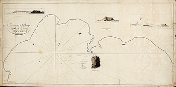
Midshipman Poynter also included a small sketch of Penguin Island in his journal (Campbell, Reference Campbell2000, Plate 14, p.114) which is probably a copy of Bransfield’s map of George’s Bay, Fig. 1. The main cone of Penguin Island (Deacon Peak) is clearly delineated on both maps but, notably, neither showed a second smaller explosion crater on its lower slopes (Petrel Crater maar). Therefore, ‘it is likely it wasn’t present then’ (J. Smellie, personal communication, 21 May 2020). Thus far, no other descriptive accounts of Penguin Island during the nineteenth or early twentieth century have been found to help narrow down the timeframe for when the maar was formed. One of the earliest reports attesting to its existence stated: ‘The northern part of the island is a plateau about 50 feet (15.2 m) high, in which is an extinct crater’ (U.S.H.O., 1943).
Chart of George’s Bay (now King George Bay), King George Island, by Lt. Bransfield. National Maritime Museum, Greenwich. Bransfield surveyed the bay on 22 January 1820 yet, curiously, this chart is dated 22 January 1821 exactly one year later. At least two other reproductions of this chart were made, one by Midshipman Charles Poynter and another by Captain Robert Fildes.

By the mid-twentieth century, more in depth geological studies led to Penguin Island being described as ‘completely unmodified by weathering and marine erosion, and is probably not much more than 100 years old’ (Barton, Reference Barton1965, p. 27).
Reports of nineteenth-century activity from Bridgeman Island questioned
Bridgeman Island is an enigma. Its geomorphology appears to belie its nineteenth century eruptive history, whereas Penguin Island’s fresh-looking young volcanic features seem to suggest it has erupted very recently. In the late 1960s, a detailed geological examination of both islands concluded that ‘reports of past activity from Bridgeman Island, in 1821, 1838, 1839 and 1850, were probably from Penguin Island, and could be attributed to geographical error’ (González-Ferrán & Katsui, Reference González-Ferrán and Katsui1970, p.153–154). This list of dates was taken directly from a list of historic activity for Bridgeman Island in a ‘Catalogue of Active Volcanoes of the World and Solfatara Fields’ (Berninghausen & Neumann van Padang, Reference Berninghausen and Neumann van Padang1960); however, it should be noted that the 1850 observation was listed as ‘1850?’ (see Account 8 below).
In the 1970s, lichenometry was used to date Penguin Island’s young landforms by calculating the rate of colonisation of surfaces by the slow-growing lichen, Rhizocarpon geographicum. This method gave a date of ‘c. 1905’ for the explosive eruption which created Petrel Crater maar and also indicated ‘the principal stratocone [Deacon Peak] and its summit crater appear to be more than 300 years old and the conditions inside the summit crater bowl became favourable for lichens to grow some 200 years ago’ (Birkenmajer, Reference Birkenmajer1979, p.69).
In 2009, other researchers encountered difficulties when they tried to re-estimate the ages of Penguin Island’s youngest volcanic features. They were unable to check the date of Petrel Crater as there were too few Rhizocarpon group lichens present to re-measure apparently due to the very strong influence of nesting southern giant petrels. Measurements were repeated on the northwestern outer slope of Deacon Peak and inside the summit crater. Using different lichen growth rates and models, the results suggested ‘that colonization of Rhizocarpon took place between AD 1943 and AD 1968’ (Angiel & Dabski, Reference Angiel and Dabski2012, p.408).
The results from the two lichenometry studies, undertaken 30 years apart, revealed significant discrepancies and appear to suggest the lichenometric dates estimated for eruptions from Penguin Island cannot be relied on.
The researchers noted that ‘the mid-twentieth century age of lichen colonization on the historically active Penguin Island volcano might support the date of the last eruption reported by whalers in the end of the nineteenth and the beginning of the twentieth century’ (Angiel & Dabski, Reference Angiel and Dabski2012, p.395).
While Penguin Island may be geologically young it should not be described as ‘historically active’ as no first-hand reports of volcanic activity have been found in the 200 years following its discovery. It is also erroneous to link Penguin’s ‘mid-twentieth-century lichenometric age’ to ‘a possible eruption reported by whalers in the end of the nineteenth and the beginning of the twentieth century’. No reports by whalers during this time period have been found regarding volcanic activity on Penguin Island. An eruption reported from Bridgeman Island in 1909 was proved to be false, and it is misleading to reassign this report to Penguin Island (see Account 10).
The proposition that historic accounts of activity from the weathered old Bridgeman volcano actually belong to the geologically youthful cone of Penguin Island, 60 km (32 NM) away, has been repeated many times, for instance: (Keller, Reference Keller1990; Araneda & González-Ferrán, Reference Araneda, González-Ferrán, Yoshida, Kaminuma and Shiraishi1991; González-Ferrán, Reference González-Ferrán, Torge, Fletcher and Tanner1993; Global Volcanism Program, Reference Venzke2013). This paper aims to show that these assertions are not based on hard evidence and that most of the observations of volcanic activity do indeed belong to the enigmatic old volcano of Bridgeman Island; not to Penguin Island.
The Bridgeman Accounts
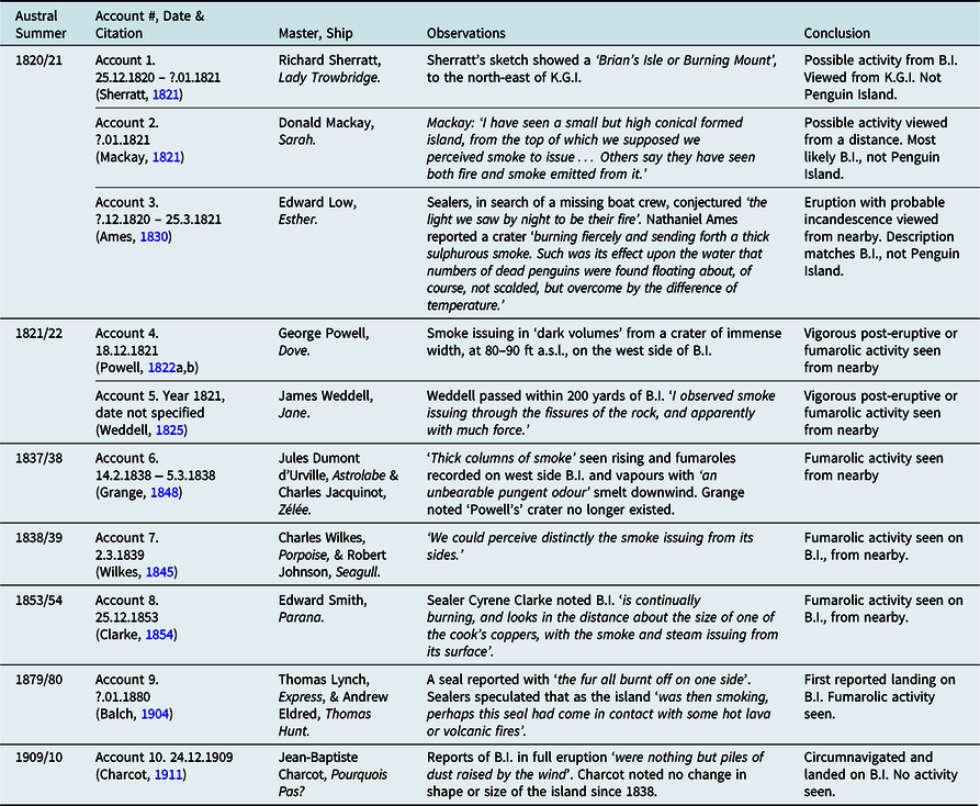
Table 1 provides a summary of ten accounts of possible volcanic activity from Bridgeman Island which are outlined and discussed in more detail below.
Summary of observations of possible volcanic activity at Bridgeman Island (B.I.).

Account 1: 25 December 1820–January 1821, examination of Richard Sherratt’s sketch reveals a ‘burning mount’
Four British ships and one American vessel were wrecked during a storm in the second summer of sealing. Two of these vessels, the Lady Trowbridge and the Hannah, both of Liverpool, were driven onto the rocks on 25 December 1820 near Cape Melville, King George Island – a place Richard Sherratt, captain of the Lady Trowbridge, graphically called the ‘Bay of Destruction’. This bay, lying between Cape Melville and Taylor Point, is still known as Destruction Bay.
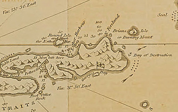
Captain Sherratt occupied his time (January and February 1821) until rescued in making a chart of the South Shetlands Islands. This was published in December 1821 in London’s Imperial Magazine. One island bore the intriguing name of ‘Brians [sic] Isle or Burning Mount’. The origin of the name burning mount was not explained in an accompanying article (Sherratt, Reference Sherratt1821).
A portion of Sherratt’s map of New South Shetland focusing on the north-eastern end of King George Island. Brian’s Isle or Burning Mount is shown to the north of the Bay of Destruction. Sherratt used a tiny flag to mark the spot where Bransfield landed and claimed the islands in January 1820. Penguin Island is the small unnamed nearshore island in the centre of George’s Bay.

Account 1 comments
Captain Sherratt’s Reference Sherratt1821 sketch was among the earliest maps to be published of the South Shetlands. It was also the first to provide a sense of the complexity of the newly discovered island chain. Sherratt used the name North Foreland (from Smith’s October 1819 voyage) and George’s Bay (from Bransfield and Smith’s January 1820 voyage), demonstrating his familiarity with these surveys even though no official results had been published.
Sherratt also used names recently bestowed by sealers during the 1820/21 season. These included Clothier Harbour, Harmony Cove and Esther Harbour named for American brigs working in the area, and Potter’s Cove, named for an English sealing captain who was the first to anchor in that bay. The use of both English and American names, on Sherratt’s sketch and in the accompanying narrative, shows that sealers of different nations were mingling and had already adopted some common geographic terms.
Although Sherratt’s sketch was naive and without scale he ably marked the ‘Bay of Destruction’ where his ship had met its fate. Nearby, ‘Brians [sic] Isle or Burning Mount’ appears to represent an island volcano. If so, which island was burning? It was definitely not Penguin Island which can be seen in the centre of George’s Bay miles away from his burning mount. Bridgeman Island, lying 48 km (26 NM) to the east of the Bay of Destruction, is the logical choice. Although incorrectly positioned by Sherratt, his burning mount was ‘almost certainly’ Bridgeman Island (Hattersley-Smith, Reference Hattersley-Smith1991, p.24).
Sherratt’s use of the name ‘Brian’s’ may stem from three rocky islets Bransfield called ‘O’Briens’ in February 1820. This small group lies more than 103 km (56 NM) to the northeast of King George Island. It is worth noting that the commander of a British Joint Services Expedition to the area was able to see both Bridgeman Island and King George Island from the 540 m-high summit of O’Brien Island. He did not mention Penguin Island (Furze, Reference Furze1979, p.46).
Sherratt’s ‘burning mount’ is of interest when considered alongside the next two accounts of volcanic activity, from an unnamed island, during the same sealing season.
Account 2: in January 1821, Donald Mackay perceived smoke issuing from a high and conical Island
Donald Mackay, captain of the Sarah, of New York, was part of a fleet of American sealers who joined the sealing-rush during the summer of 1820/21. A letter from Mackay from ‘among the Antarctic islands, lat. 63, south, long. 61, west, or thereabouts’ was first published in June 1821. Mackay wrote of the land recently discovered and called New South Iceland by some and New South Shetland by others which was ‘but little known yet, except the range of islands at which we now are, extending from E.N.E to W.S.W about two hundred miles in length’ (Mackay, Reference Mackay1821).
I have seen a small but high conical formed island, from the top of which we supposed we perceived smoke to issue; but we were at too great a distance to be positive of the fact. Others say they have seen both fire and smoke emitted from it. From the circumstances of the island being bare of snow, there is little doubt of its being a volcano. There is a small island at no great distance from our present position, which has been described to me, by several who have visited it, as being so hot that, on many parts of it, the foot or hand cannot be held to the sand, and that on the shore of a basin forming a small harbor, (probably the ancient crater of a volcano), the water boils (Mackay, Reference Mackay1821, p. 237).
Account 2 comments
The description in Captain Mackay’s letter, of hot sand and boiling water on an island close to his position at latitude 63 south, longitude 61 west ‘or thereabouts’, may be the earliest report of geothermal activity from Deception Island. Its hidden harbour had only recently been entered and the island named, on 15 November 1820, in the logbook of American sealer Nathaniel Palmer (Stevens, Reference Stevens1954, p.54).
No chart existed of what Mackay simply called ‘the Antarctic islands’ in January 1821; therefore, the American captain was unable to name any of his surroundings. His description of a ‘small but high conical formed island’, seen from afar, best describes Bridgeman Island. From a distance, Penguin becomes part of the landscape of King George Island, whereas Bridgeman is seen as an outline, in profile, alone in Bransfield Strait.
Account 3: late December 1820–March 1821, Nathaniel Ames reported an island ‘burning fiercely and sending forth a thick sulphurous [sic] smoke’
Harvard graduate Nathaniel Ames worked aboard the Esther (Captain Edward Low) sailing in company with the Emerald (Captain John G. Scott) during the 1820/1821 season. Both vessels were from Boston. In late December 1820, the Esther anchored for the first time in a little cove on the north side of King George Island about 30 km from the most north-eastern extremity of the land (North Foreland). The vessel soon moved to Potter’s Cove which Ames described as the best harbour among the islands. The Esther was based here for the rest season until they left the South Shetlands on 25 March 1821.
Ames was bowman in one of the Esther’s boats. He described sealing around the coastline of the South Shetlands in a clinker-built, white cedar craft, sharp at each end like a whale boat. This was manned with four men and a boat steerer. He and fellow sealers spent most of the summer in search of seals, traversing some 250 miles (400 km) of rocky and rough coastlines too dangerous for the mother ship. They slept ashore in camps often beneath their boat (Ames, Reference Ames1830).
I have already mentioned volcanic appearances; there were two volcanoes ‘in blast’ during our stay here, or rather they kept up a continual smoke, which indicated eruptiveness. Before we left, one of them, a mere rock of a conical form and of no great size, situated about thirty miles from the northern extremity of the land, broke out with considerable violence. We had heard of a boat belonging to the Queen Charlotte being absent, and supposed lost, and conjecturing the light we saw by night to be their fire, we sent a boat well provided with clothes, provisions, &c to the relief [of] the supposed sufferers. It was soon ascertained to be the volcano, the crater of which was about one third the height of the rock from the water, and was burning fiercely and sending forth a thick, sulphurous smoke. Such was its effect upon the water that numbers of dead penguins were found floating about, of course, not scalded, but overcome by the difference of temperature, as a codfish becomes insensible and finally dies at the surface of the water. I thought it would be a capital place to establish a steam factory, the fuel would cost nothing and it would be handy, besides, to the markets on both sides of Cape Horn (Ames, Reference Ames1830, p.134).
Account 3 comments
Nathaniel Ames provided sufficient detail in his account for us to recognise his ‘mere rock of conical form and no great size’ as Bridgeman Island. He described how his boat crew had rowed some 30 miles (48 km) to investigate the signal fire of a group of marooned sailors on an offshore island. The distance from Cape Melville to Bridgeman Island fits exactly with Ames’s estimate. Sealing crews routinely rowed great distances, upwards of 85 miles (136 km) or more, as they searched the coast for prey (Powell, Reference Powell1822a; Ames, Reference Ames1830; Smith, Reference Smith1844).
Although Ames did not know or use the names King George Island, Penguin Island or Bridgeman Island in his account, it is clear from his narrative that the Esther’s boat crews worked the coastline between Esther Harbour and Potter’s Cove from late December till the middle of March 1821. Confirmation that Ames spent time close to Cape Meville was provided by his encounter with a group of shipwrecked British sealers, from Lady Trowbridge and Hannah, at Sherratt’s Bay of Destruction. Ames called this ‘Wreck Beach’ (Ames, Reference Ames1830).
Ames’s crew did not row to investigate a volcano; they found one by accident when attempting to rescue another boat crew. Ames’s observation of ‘the light we saw by night to be their fire’ suggests he may have seen volcanic incandescence. After the summer solstice, and from, 1 January onwards when the sun is at least 6° below the horizon, incandescence would appear as ‘fire’. At King George Island, there are 4.5 h of civil twilight on 1 January, 7 h of combined civil and nautical twilight on 1 February and 10 h of twilight and darkness on 1 March. Civil twilight or darker is akin to the times of day in the city when city streetlights are on (Smithsonian, 2019). Incandescence would have appeared as fire for the duration of an approximately three-hour row to the island (assuming an average minimum average speed of 15 km/hr).
Ames wrote of two ‘volcanoes in blast’ that season. From Potter’s Cove, he and his crew would have rowed past Penguin Island to reach Wreck Beach, yet he made no comment about any volcanic activity along their route, thus ruling out activity from this source. Deception Island would be the obvious contender for the second volcano ‘in blast’, but there is no other information in Ames’s account to support this notion.
Coincidentally, the Russian Naval Expedition visited the South Shetland Islands during the same season as Sherratt, Mackay and Ames. Whilst in the port of Sydney, Australia, in September 1820, Captain Fabian von Bellingshausen (Vostok) and Mikhail Lazarev (Mirnyy) had learned of Captain Smith’s discovery. At the end of October, the expedition headed south, again, to continue an extraordinary voyage of discovery and to complete a circumnavigation of the globe in high southern latitudes.
The Russian expedition reached the South Shetlands on 24 January 1821 to find numerous sealing vessels in the area. American captain, Nathaniel B. Palmer went aboard the Vostok and met with its commander, a famous encounter that has been the subject of much speculation. Afterwards, Bellingshausen continued his survey of the group ‘unaware of the island names already given by Smith, Bransfield and the British and American sealers working there in 1819/20 and the early part of the 1820/21 season’ (Hattersley-Smith, Reference Hattersley-Smith1991, p.16).
While Bellingshausen had described volcanic activity in the South Sandwich Islands in December 1819, he saw nothing of a similar nature as he sailed the length of the South Shetland chain. He named all the main islands in the group including ‘Teille’ (Deception). In the vicinity of Penguin Island, at the eastern end of ‘Waterloo’ (King George Island), he noted landforms ‘not unlike Sopka’ and this was explained in Bellingshausen’s translated narrative to mean ‘extinct volcanic cones’ (Debenham, Reference Debenham1945, 2, p.427, footnote 3). On 26 January 1821, ‘Yelena’ (Bridgeman) was seen at a distance. Bellingshausen wrote ‘we saw to the east a small island which consists of rocks and lies 24 miles S 72° E from the southeast headland of Waterloo [King George] Island. I named it Helena Rock’ (Debenham, Reference Debenham1945, 2, p.427).
The expedition rounded the rocky easternmost point of Waterloo in order to approach and send boats ashore at North Foreland. The crews of the two Russian vessels spent most of the day only about 55 km (30 NM) from Bellingshausen’s Helena Rock. The shore party gathered specimens including rocks, moss, seaweed, three live seals and some penguins. Helena Rock was not mentioned again as the vessels sailed northeast to explore the rest of the chain.
Account 4: 18 December 1821, George Powell reported Bridgman’s [sic] Island was a volcano
Less than a year later, two British sealers, George Powell (Dove) and John Wright (Eliza), were back in the South Shetlands for the third season of sealing (1821/22). Leaving Captain Wright moored in Clothier Harbour at the heart of the central islands of the group, Powell sailed hither and yon in the Dove deploying boat crews to hunt for seals. As he went, he gathered information about anchorages, winds and tides.
In early December, Powell linked up with Stonington sealer Captain Nathaniel Palmer (James Monroe) at Elephant Island. Having it in mind to search for new sealing grounds to the east, and knowing that it was not safe for one vessel to go alone, Powell and Palmer set out together and fortuitously soon discovered more islands. On 7 December 1821, George Powell landed and
took possession in the name of King George the Fourth and leaving a bottle, with a note, stating the particulars of the discovery; and as I imagined it to be the first land discovered since the coronation of our most gracious sovereign, I have named it Coronation Isle (Powell Reference Powell1822a, p.8).
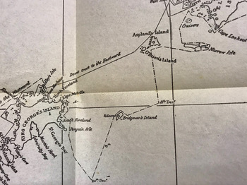
Powell returned to Elephant and Clarence, picking up and dropping off crews as he made his way southwest via Narrow (Gibbs), Aspland’s and O’Brien’s islands, en route to his rendezvous with Wright at Clothier Harbour. On 18 December 1821, the track chart of his voyage shows he diverted from his direct course to investigate Bridgman’s [sic] Island (Balch, Reference Balch1902, opp. p.96). In an extract from his journal, Powell wrote:
This island is volcanic; for when it bore S by W, by compass, and distance 9 miles, it appeared to emit smoke from five craters; but, when it bore NNE, and distance one mile and a half, I could plainly see it was but one crater, of immense width, from which the smoke issued in dark volumes; after passing from this crater, the smoke branched off into the different columns of the rocks, and ascended upwards; it was from this circumstance that gave it the appearance of five craters in a S by W direction. Bridgman’s Island is about 200 feet high, and about four miles in circumference: the crater is situated on the west-side of the island, and is about 80 or 90 feet from the surface of the sea; the whole of the island assumes the appearance of burnt bricks; the SW point is low, and was covered with penguins. It blew very hard while I was off this island, which circumstances prevented me from landing on it; the wind was from the SW with a heavy sea running, and the only part of the island that is accessible, is the SW point (Powell, Reference Powell1822a, p.11).
Account 4 comments
Powell’s ‘Notes on South Shetlands &c’ (Powell, Reference Powell1822a) and his ‘Chart of South Shetland, including Coronation Island &c’ (1822b), were published on 1 November 1822 by private mapmaker, R.H. Laurie, chart seller to the Admiralty. Powell’s notes show he carried a chronometer aboard his vessel. Powell, with Laurie, retained many of Smith and Bransfield’s place names including North Foreland, George’s Bay, Penguin Island, Cape Melville and King George Island which are of interest to this discussion. Bridgman’s [sic] Island (volcano) was situated in Bransfield Strait in relation to all of these points. There was clearly no confusion between Penguin and Bridgeman islands in Powell’s mind.
Powell acknowledged his notes and chart were a team effort. He thanked British sealing captains Ralph Bond, John Walker and Charles Robinson for charting the south side of the islands, a part of the island chain he never visited. British sealing captain Robert Fildes was not mentioned in Powell’s notes, but was recognised on the chart itself by the names ‘Fildes Strait’ and (almost certainly) ‘Robert’s Island’. The latter name, immortalised Fildes’s second shipwreck in the brig Robert at Clothier Harbour in March 1822. Sealers’ names used by Fildes on his early sketches (Livingston’s, Sea Elephant and the Harbour of Deception) also appeared on Powell’s chart helping to secure these as enduring place names. American Nathaniel Palmer was not mentioned directly either; however, a stretch of Antarctic coastline was named ‘Palmer’s Land’ in recognition of the Yankee sealer’s early exploratory efforts.
On 30 November 1822, less than a month after the publication of Powell’s chart, the British Admiralty published ‘the earliest official chart of an area in the Antarctic’ (Headland, Reference Headland2009, Index No.582, p.138). This long-awaited chart was based on the results of Bransfield’s survey of early 1820. Information gathered during two subsequent sealing seasons meant it was now redundant. Powell’s new chart was superior in scope and detail and became the map of choice. Significantly, Bridgeman Island was labelled a volcano on Powell’s chart.
Account 5: 1821/22, James Weddell observed ‘smoke’ issuing with great violence from Bridgman’s [sic] Island
British sealer James Weddell made three major sealing voyages ranging from Patagonia to the Falkland Islands, South Orkney Islands and the Weddell Sea. He sealed in the South Shetland Islands twice (1820/21 and 1821/22) and, during the latter season, ‘reported Bridgeman Island in eruption’ (Headland, Reference Headland2009, Index No.568, p.135).
To the eastward of Cape Melville is Bridgman’s [sic] Island, which is evidently volcanic, as in passing it in the year 1821, within 200 yards, I observed smoke issuing through the fissures of the rock, and apparently with much force. The figure of this island is nearly round; and it is about one-eighth of a mile in diameter, and 400 feet high, partaking of the form of a sugar loaf (Weddell, Reference Weddell1825, 133–134).
Account 5 comments
James Weddell had trained as a navigator in the British Royal Navy and was well versed in the use of chronometers. He carried three, on all three of his voyages to the southern sealing grounds, for accuracy and in case of equipment failure. He wrote:
such perfection in this most useful machine cannot be too much appreciated by commanders of ships, who, by assistance of so precise a nature, can easily avoid embarrassment in critical situations, where many lives and much valuable property frequently depend on a true knowledge of the ship’s place (Weddell, Reference Weddell1825, p.38).
Weddell compiled his own chart of the islands starting with a foundation provided by Smith and Bransfield. He accurately added their place names on his chart including both Penguin and Bridgeman islands. Weddell certainly knew it was Bridgeman that was active during the year 1821.
Like Powell, Weddell added other names used by sealers, such as Deception Island, to his chart. He also coined many names including Bransfield Strait which are still in use today. He added the name South Orkney Islands to his chart, seemingly unaware the islands had already been named ‘Coronation’ and ‘Powell’s Group’ (Powell, Reference Powell1822b). Weddell’s name for this group would prevail.
By 1827, the first phase of sealing had effectively ceased as it was no longer economic to seal in this locality where almost all the seals had been killed. This is relevant to the discussion about volcanic activity in the archipelago because as the seals ‘disappeared’ so too did the number of sealers and potential witnesses to any unusual activity. The number of sealing expeditions plummeted from more than 140 per season to only a handful of vessels in the 1830s and 1840s (Dickinson, Reference Dickinson2007; Pearson, Stehberg, Zarankin, Senatore, & Gatica, Reference Pearson, Stehberg, Zarankin, Senatore and Gatica2010). Despite this, and even though fewer vessels were abroad in the region during this era, two more reports of volcanic activity from Bridgeman Island surfaced in the late 1830s, this time not from sealers, but from two notable exploring expeditions.
Account 6: 14 February – 5 March 1838, Dumont d’Urville’s expedition described an unbearable pungent odour from Bridgeman
The French Antarctic expedition of 1837-40, led by Captain Jules Sebastien Cesar Dumont d’Urville in the Astrolabe, with his second-in-command Charles Hector Jacquinot in the Zélée, explored the South Shetlands from 14 February to 5 March 1838. Dumont d’Urville was a highly skilled navigator who carried chronometers on this expedition (Gascoigne, Reference Gascoigne, Dunn and Higgitt2015). The expedition was extremely well-prepared carrying a variety of charts of the region including those by Powell and Weddell (Grange, Reference Grange1848). The expedition probably carried an identical version of Powell’s 1822 chart which had been translated into French and published in Paris (Powell, Reference Powell1824). The French expedition also carried a similar chart updated to include new geographic features from sealer James Hoseason’s 1824/25 survey of Hughes Bay (Norie, c. 1825). As they approached the South Shetlands, they identified the islands of Gibbs, Aspland, and O’Brien and, then, examined Bridgeman Island:
Thick columns of smoke rose from it and attracted the attention of the Commander who full of zeal had wanted us to land on the island to make scientific observations. But the fury of the sea surge at the base of the volcano made it impossible and so we were obliged to make our observations remotely.
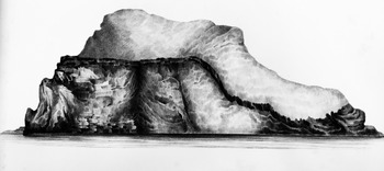
Bridgeman island (Plate 1, Atlas Géologie) has a rounded-shaped peak; its height is about 160 metres, in its largest diameter from north to south it is a little more than a mile wide; its reddish colour looks like burned bricks; on these reddish scorias we could see some small black’ish stacks which seemed to be lava debris; it is more a huge heap of ashes, rapiili [sic], volcanic debris, than a real volcano; there is no crater, and shows everywhere a rounded shape; a few lava flows can be easily identified through the debris which plunge into the sea. The fumaroles are only on the west side of the island, and there, the rocks had the reddish colour of lava degraded by sulphuric steam; these vapours which we could smell lee side had an unbearable pungent odour; the southeast side of the volcano showed enormous landslides; we tried to map it in the Atlas drawing. The scarp formed by these landslides was nearly 100 m high; in the middle of reddish tuffs we could see a few blackish lava flow beds. These flows didn’t have the same incline, the lower slopes looked like two layers inclined in opposite directions, as if they were broken in the middle, and the two halves would have tilted towards the sea; on the roof shape formed by these layers, were a few horizontal brown lava layers; it would be difficult to guess on which side the crater which had emitted all this debris was situated; seeing the lava flows inclined from NW to SE we think the crater was on the south side, and after having spewed lava and ashes in huge quantity it sank underwater; the huge landslide towards the south and the loose aspect of these diverse volcano layers, seem to validate this theory. The revolutions which seemed to have struck the island, which were shown by the lava layers and disposition of the scoria, are perfectly confirmed by comparing the current volcano status with that described by Powell … The shore of the same side is jammed by huge blackish blocks, which seem to be lava flow fragments broken during the crater collapse. The irregular lava layers’ dispositions indicate there have been frequent disturbances in the volcanic openings, like it happens on all intermittent volcanoes of which the melted products take different routes for each eruption. We have seen no trace of stratified rocks. Here is an isolated volcano, surrounded by deep sea, located at least 30 miles from the closest land at King George Island; is it an upheaval crater, or an eruption crater? All seems to indicate at least some close links with those crater types. We have deep regrets of not having sounded around the island; some careful sounding would have thrown some light on this question (Grange, Reference Grange1848, 33–36).
Account 6 comments
The geological reports of the French expedition did not mention Penguin Island at all. They recognised only ‘two active volcanoes, Deception Island, … and the little volcano Bridgeman’ in Bransfield Strait. (Grange, Reference Grange1848, p.41). While Bridgeman Island was described in great detail, unfortunately, the expedition was unable to enter the harbour at Deception Island (Grange, Reference Grange1848, 36–38).
Account 7: 2 March 1839, U.S. Exploring expedition witnessed smoke and smelt sulphur
Two vessels from the United States Exploring Expedition of 1838-42, commanded by Charles Wilkes reached the South Shetland Islands during a month-long Antarctic journey in March 1839, their first cruise south of 60°S. The brig Porpoise (Lt. Cadwalader Ringgold, U.S.N.) with Wilkes on board and the tender Seagull (Lt. Robert E. Johnson, U.S.N,) sighted Bridgeman Island on 2 March 1839.
On the 2d [sic], at daylight, we made O’Brien’s and Aspland’s Islands, to the eastward, with many ice-islands, some of a tabular form, and from half a mile to a mile in length. The temperature of the water was 34 degrees. Through the fog and mist, we got a sight of Bridgeman’s Island, and stood for it, with the intention of landing on it. The fog cleared off as we approached it, and we could perceive distinctly the smoke issuing from its sides. We made it in latitude 62°06’ S, and longitude 57°10’ W. I determined to land, although the fog was hovering in the horizon around us, and ordered a boat to be prepared. While in the act of getting ready, in less than ten minutes, we were enveloped in a fog so dense, that we could not see three lengths of the brig. We were now a short distance from and under the lee of the island, and perceived a strong sulphureous smell. We waited for some time, in hopes of its clearing, but we were disappointed, and I therefore deemed it advisable to proceed under short sail, feeling our way to the southward, with the expectation, every moment, of encountering icebergs. This island is about six hundred feet high, and of the shape of a flattened dome. The sea was quite smooth, but the long swell was heard dashing against it and the icebergs as we passed them (Wilkes, Reference Wilkes1845, p.136).
Account 7 comments
There could be no doubt Charles Wilkes wrote of Bridgeman Island. Before leading the U.S. Exploring Expedition, he had headed the U.S. Navy’s Department of Charts and Instruments. He spent a small fortune outfitting the exploring expedition with 12 sextants and 28 marine chronometers which he worked tirelessly to synchronise (Smithsonian, 2021).
Both the French (March 1838) and American (March 1839) expeditions commented on the pungent smell indicating fumarolic activity at Bridgeman Island. Neither was able to land due to the swell. It is unfortunate as a landing would have either confirmed or disproved their seaborne observations of an unbearable pungent odour (Grange, Reference Grange1848) and a ‘strong sulphureous smell’ (Wilkes, Reference Wilkes1845).
Account 8: 25 December 1853, sealers reported ‘Brigham’s’ [sic] Island ‘continually burning’
Volcanic activity at Bridgeman Island was reported by Cyrene M. Clarke who sailed under Captain Edward Smith of the Parana of Sag Harbour, New York. On 2 December 1853, the Americans reached Elephant Island. Boats were landed and camps set up on the western shore. During the next 3 weeks, hundreds of elephant seals were despatched and 700 barrels of oil taken on board. On 25 December, the Parana sailed southwest from Elephant Island en route to the sheltered harbour of Potter’s Cove, King George Island where they planned to land most of their provisions and stow the ground tier of the brig.
December 25 th … Eight o’clock pm, 60 miles on our passage, and opposite Brigham’s [sic] Island, a volcanic rock rising, in a conical form from the water. It is continually burning, and looks in the distance about the size of one of the cook’s coppers, with the smoke and steam issuing from its surface. 26 th - Becalmed abreast Penguin Island in Admiralty Bay, on the eastern side of King George’s Island, the island being about five miles distant. … 27 th - Still at Penguin Island with a head wind. Two o’clock pm, wind fair. Potter’s Cove in sight (Clarke, Reference Clarke1854, p.35).
Account 8 comments
This account demonstrates crewman Cyrene Clarke’s familiarity with the geography of the South Shetland group. Charts of the South Shetland Islands had been available for three decades but, even so, he mistakenly said he was becalmed abreast of Penguin Island in Admiralty Bay. Penguin Island is in King George Bay. Clarke’s geographical error is not relevant to the discussion as he observed both ‘Brigham’ and Penguin islands, at close quarters and observed volcanic activity from only one island. That island was Bridgeman.
One other brief reference to volcanic activity taking place a few years earlier, during the year ‘1850?’ from Bridgeman Island, was listed in a catalogue of Antarctica’s active volcanoes (Berninghausen & Neumann van Padang, Reference Berninghausen and Neumann van Padang1960, p.16). The addition of a question mark after the 1850 entry may indicate the authors of the catalogue held some reservations about this particular listing. They quoted from an early German publication (Landgrebe, Reference Landgrebe1855) stating: ‘According to Reference Landgrebe Landgrebe, 1855 , p.233, fumarolic activity was found in 1850 on the west side of the [Bridgeman] island’. The original source of this quote has not been located and, because of a lack of any other verifiable information, it has not been included as a separate account.
Account 9: January 1880, sealers land on Bridgman [sic] Island and kill a seal with ‘fur all burnt off on one side’
The first recorded landing on Bridgeman Island took place in January 1880 when American sealers from Stonington, Connecticut landed to search for missing crew from an overdue vessel from their home port. In October 1877, the schooner Charles Shearer had left a sealing gang in southern Chile, headed for the South Shetlands and disappeared without trace (Headland, Reference Headland2009, Index No.1360, p.210).
Captain Thomas B. Lynch, now of Peace Dale, Rhode Island, sailed in 1879 from Stonington in the schooner Express. In January 1880, he was for some time in company with Captain Andrew Eldred on the schooner Thomas Hunt, at the South Shetlands. They landed on several of them and caught 36 fur seal. One of these, on Bridgman [sic] Island, had the fur all burnt off on one side; they thought that, as Bridgman Island was then smoking, perhaps this seal had come in contact with some hot lava or volcanic fires (Balch, Reference Balch1904, 83–84).
Account 9 comments
‘In view of later reports this description appears to be a little exaggerated’ (Adie, Reference Adie1957). ‘The tale of a seal with burnt fur sounds apocryphal. My strong suspicion is that it was simply a moulting seal’ (J. Smellie, personal communication, 4 October 2019). Lynch and Eldred’s account is strange, but we should not be distracted by the burnt seal. Rather, it is worth noting this was the first reported landing on Bridgeman Island and ‘Bridgeman Island was then smoking.’
Lynch and Eldred never found the fifteen missing seal hunters. Nearly a century later, substantial ship wreckage discovered during a survey of Elephant Island in 1970/71 was probably that of the Charles Shearer (Headland, Reference Headland2009, Index No.3127, p.424).
Account 10: Charcot’s men find no sign of volcanic activity on 24 December 1909
By the early 1900s, the sealing era was over, and it was now the turn of the whalers. In 1909, nine large factory ships were moored along the shores of Whalers’ Bay, Deception Island (Riffenburgh, Reference Riffenburg2006).
In late December 1909, French explorer Jean-Baptiste Charcot called at the busy whaling port. He resupplied his vessel Pourquois Pas? with coal, then sailed directly to ‘Bridgmann’ [sic] Island to investigate ‘several reports by captains, notably from one of the whalers that we have just left, are to the effect that Bridgmann Island is in full eruption, so that it is interesting to try and land there’ (Charcot, Reference Charcot1911, p.276). On 24 December 1909, Charcot made a circuit of Bridgeman Island and sent scientists Rene Godfroy and Ernest Gourdon ashore.
At 7.30 Gourdon, Godfroy and two men start off in the dinghy and succeed in getting ashore on a little beach to the southeast, somewhat sheltered from the swell prevailing at the moment. During this time we take a sounding, which gives 328 fathoms. On the beach, the only spot on the island where the shore does not rise up in cliffs or in high steep rocks, Gourdon saw some thirty seals. He did not discover the slightest trace of present volcanic activity, but numerous proofs of comparatively recent activity. We reached the same conclusion while making a circuit of the island as close as it is safe to go. It is clear, as often happens, that the ‘smoke’ and ‘vapours’ mentioned as proof of volcanic activity, were nothing but piles of dust raised by the wind, clouds clinging to the summit or even snowdrifts. … This rugged, barren and almost snowless island is a curious sight as it rises in isolation from the midst of the sea, tinted by the brick-red tufa and yellowish scoriae. We take numerous photographs of it, of which one notably proves not only the skill of the artist accompanying Dumont d’Urville, whose picture is before our eyes, but also that there has been no change of shape since the passage of the Astrolabe and the Zilée [sic] (Charcot, Reference Charcot1911, 275–276).
Account 10 comments
In December 1909, Charcot left Port Foster, Deception Island, sailing past Penguin Island on his way to investigate Bridgeman Island. He circumnavigated the island then sent geologists ashore. This was the second recorded landing. Charcot’s men ‘did not discover the slightest trace of present volcanic activity, but numerous proofs of comparatively recent activity’. Despite the ambiguity of this statement Charcot made it abundantly clear in his account that there had been no eruption.
Could the Deception Island whalers have been mistaken as some have suggested and seen an eruption from Penguin Island instead? Penguin and Bridgeman islands were well known landmarks to the crews of whale chasers working the waters of Bransfield Strait. Modern whaling had begun in the South Shetlands, on 28 January 1906, from the factory ship Admiralen in Admiralty Bay (Headland, Reference Headland2009, Index No.1652, p.242). Admiralty Bay and Penguin Island, in King George Bay, lay only about 25 km (13 NM) apart. Weather permitting, King George Bay was used as an anchorage by the whalers just as it had been by explorers and sealers since 1820. Thus, it seems highly unlikely an eruption from Penguin Island during the summer season would have escaped the notice of the whalers.
Changes at Bridgeman Island over time
Nine first-hand accounts outlined above refer to activity which is consistent with some form of volcanic activity from Bridgeman Island. They cover a 60-year period (1820–1880). A tenth account (Account 10) from 1909 found no volcanic activity. Although visitation of the islands was intermittent after the first intensive period of sealing in the early years of the 1820s, mariners continued to pass through the South Shetlands most summers but no further first-hand reports have been found.
It appears there may have been two episodes of activity, the first in the early 1820s and the second in the late 1830s (see Table 1). Six separate witnesses appear to have observed vigorous fumarolic gas and steam emissions, ruling out insolation-induced steam as their cause. This, although sometimes quite dense, rises only passively for a few metres and does not have an intense sulphurous odour. Ames (Account 3, 1820/21) spoke of a ‘light we saw by night’ which he interpreted as ‘fire’. This may be a report of incandescence. It could be significant that this observation was made during the first cluster of reports, one of which also noted ‘numbers of dead penguins … found floating about’ the island, a most unusual event.
Only two out of the ten observations mentioned Bridgeman Island having a crater. Ames (Account 3, 1820/21) recalled a crater ‘one third the height of the rock from the water … burning fiercely and sending forth a thick sulphurous smoke’. Powell (Account 4, 1821/22) described ‘one crater, of immense width … on the west-side of the island, …about 80 or 90 feet from the surface of the sea’. He also marked a crater on his map of Bridgeman Island (Fig. 3). However, Weddell (Account 5, 1821/22) did not mention a crater when describing activity from the island that same summer. Dumont d’Urville (Account 6, 1838) examined Bridgeman Island from a distance, speculating some catastrophic event, perhaps a landslide, had destroyed the crater observed by Powell in the early 1820s. Charcot’s geologists in 1909 confirmed there was no crater. Similarly, another party of geologists who landed on Bridgeman in the mid-1960s found no evidence of a crater or of recent fumarolic or volcanic activity (González-Ferrán and Katsui, Reference González-Ferrán and Katsui1970).
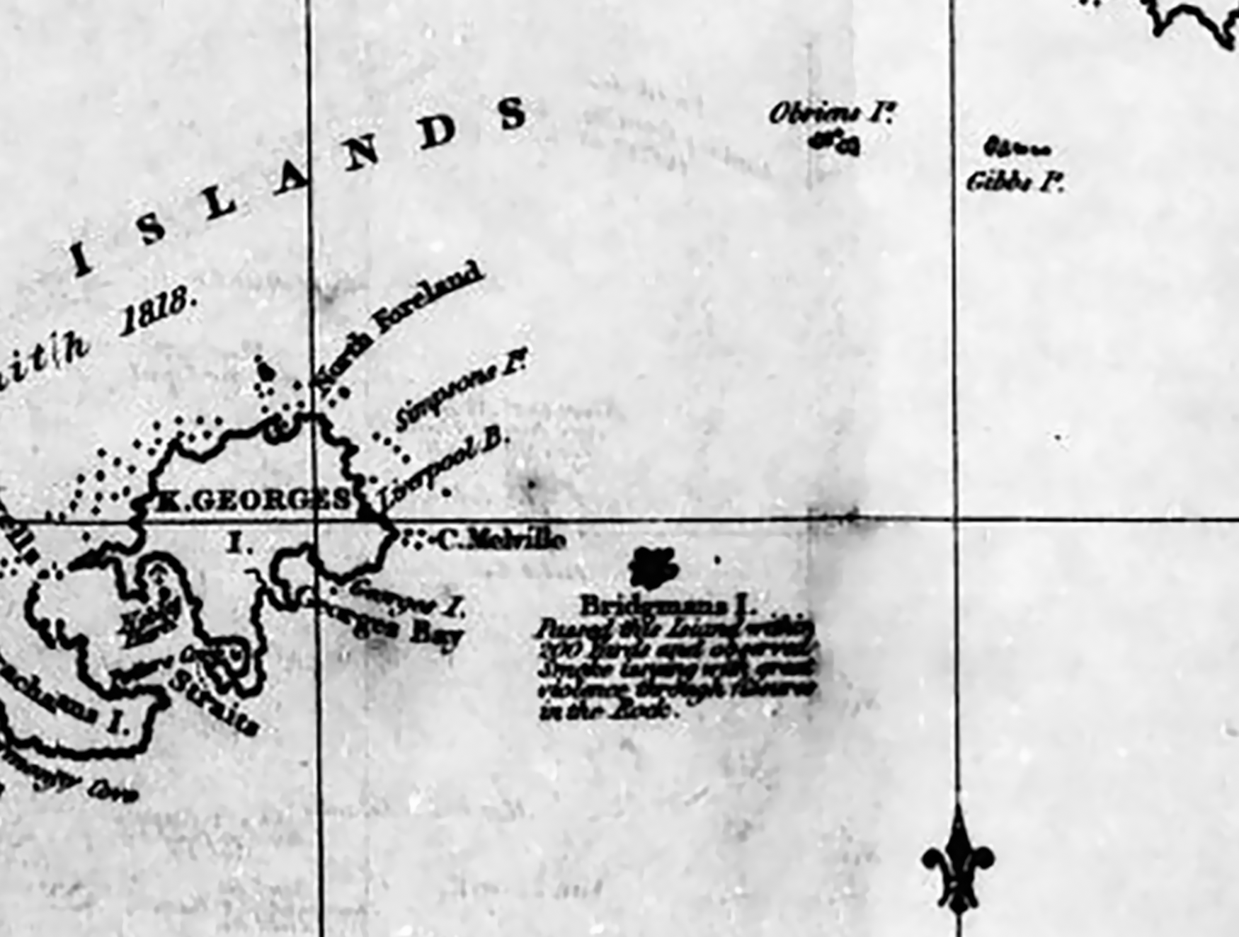
Captain George Powell’s track chart showing his diversion in the Dove to Bridgman’s [sic] Island on 18 December 1821 (Powell, Reference Powell1822b) . This portion of Powell’s chart shows Penguin Isle (at the eastern end of St George’s [sic] Bay) and Bridgman’s Island (in Bransfield Strait).

In fact, no crater has existed from at least 1838. Yet an early catalogue of Antarctica’s active volcanoes stated ‘a crater was observed about 90 feet (27 m) above the sea on the west side of the island’ (Berninghausen & Neumann van Padang, Reference Berninghausen and Neumann van Padang1960, p.16). The source of this erroneous report appears to be Powell’s 1821 observation (see Account 4 above) with his heights converted to a metric equivalent in the catalogue.
A close-up view of a section of James Weddell’s ‘Chart of South Shetland’, August 1825 (Weddell, Reference Weddell1825, opp. p.132). Penguin Island, labelled ‘Georges I’, was shown as a small dot at the eastern edge of Georges Bay. Bridgman’s [sic] Island was shown offshore, as a larger dark shape, accompanied by text stating: ‘Bridgmans [sic] I. Passed the island within 200 yards and observed smoke issuing with great violence through fissures in the rock’.

Several observers described the shape of Bridgeman Island. Ames (Account 3, 1820/21) rowed to ‘a mere rock of a conical form and of no great size’. Powell (Account 4, 1821/22) referenced ‘one crater, of immense width’. During the same summer, Weddell (Account 5, 1821/22) provided a very different perspective, describing the island as ‘partaking of the form of a sugar loaf’. Dumont d’Urville (Account 6, 1838) noted that Bridgeman ‘has a rounded-shaped peak’. Wilkes (Account 7, 1839) described the island as having the shape of ‘a flattened dome’. Clarke (Account 8, 1853) saw ‘a volcanic rock rising, in a conical form, from the water’. Grange’s (Reference Grange1848) various descriptions of lava layers, ‘recent’ volcanic rock, its shape and size (‘a small round but high island … of no great size’), generally are consistent with modern accounts.
The vertical and horizontal dimensions given historically for Bridgeman Island differ by 60–180 m in height and up to 1100 m long, the longest dimension from its current known size (900 m by 600 m and up to 240 m high). Some of these variances seem relatively large but possibly not unreasonable given the technology available to the various observers and conditions. It is possible that cliff collapses or landslides altered the size and shape of Bridgeman Island and destroyed a crater before Dumont d’Urville’s visit in 1838, given also that Grange, on that expedition, interpreted cliffs up to 100 m high had resulted from landslides. Charcot’s geologists (1909) were impressed with the accuracy of Grange’s 1838 sketch (Fig. 5) and concluded there had been ‘no change of shape’ since Dumont d’Urville’s visit between 1838 and 1909.
Bridgman [sic] volcano, 1838; engraving by Jean Delarue after Jules Grange, Atlas Géologie (Grange, Reference Grange1848, Plate 1).

Given the differing estimates of the size of the island, they are of little help in determining the extent of any changes. Powell (Reference Powell1822a) estimated its circumference as ‘about four miles’ [6–7 km]; Weddell (Reference Weddell1825) estimated the diameter to be ‘about one-eighth of a mile’ [circumference <0.8 km], and Grange (Reference Grange1848) reported that ‘its largest diameter from north to south [was] a little more than a mile wide’ [circumference 5–6 km]. The present-day circumference is about 2.5–3 km (from sketch map in Smellie, Reference Smellie, LeMasurier, Thomson, Baker, Kyle, Rowley, Smellie and Verwoerd1990). If Weddell made a gross underestimate, it is possible to speculate there was significant change between 1821 and 1838 and now, which would be consistent.
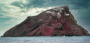
Small differences between modern-day photos taken from the same aspect (for example, in 2005, Fig. 6) indicate some mass loss affecting the base of the island and close to the summit of the island. This would not be unexpected.
Bridgeman Island, 5 January 2005. Miguel Angel Otero Soliño, Creative Commons, Wikimedia.org.

Conclusion
Ten accounts of volcanic or fumarolic activity from Bridgeman Island, from 1820/21 to 1909, were examined. With no chart available, the first three witnesses to volcanic activity during the summer of 1820/21 could not name the island making it difficult to be certain that Bridgeman Island was the source. However, by the following season of 1821/22, some of Captain William Smith’s and Lt Edward Bransfield’s basic place names were in use by sealers, and a good chart of the region, with longitudes determined by chronometer, was published in 1822. This allowed the next six observers to pinpoint Bridgeman Island as the source of activity. The tenth report by whalers of an eruption from Bridgeman was proved to be false.
The observations of the six mariners who named Bridgeman Island as the source of volcanic or fumarolic activity are highly credible. These include those made by influential British sealers George Powell and James Weddell (1821) both of whom helped put the South Shetlands Islands on the map. The next two reports were from two notable explorers Jules Dumont d’Urville and Charles Wilkes who both observed activity from the island in the late 1830s. Powell, Weddell, Dumont d’Urville and Wilkes were all chronometer-carrying explorers recognised for their chart-making abilities and extraordinary feats of navigation – the discovery of the South Orkney Islands (Powell with Nathaniel Palmer), Weddell Sea (Weddell), Adélie Land (Dumont d’Urville) and Wilkes Coast (Wilkes). Bridgeman Island had been on the South Shetland charts for more than 30 years when it was, again, specified as the source of ‘burning’ and ‘smoke’ in the years 1853 and 1880. These published accounts from sealers further add to the body of evidence.
The analysis of these nineteenth-century historical accounts shows a consistency of observation that is compelling despite the geomorphology of Bridgeman Island. Although tempting to reassign the Bridgeman accounts to the younger-looking Penguin Island, this idea does not stand up to scrutiny and appears to be ill-founded. The historic record clearly documents volcanic activity from Bridgeman Island, and no such evidence has been found from Penguin Island.
Acknowledgements
Prof. John Smellie provided ongoing encouragement and direct assistance by visiting BAS to track down several illusive and important references. Dr Jim McAdam, editor of the Falkland Islands Journal, shared various papers from the journal including Jones (Reference Jones1983). Michael Pearson provided timely assistance by sending digital copies of Robert Fildes’s sketch maps of harbours and anchorages in South Shetland Islands.
Research assistance was provided by the Macmillan Brown Library (Christchurch, New Zealand), the Alexander Turnbull Library/National Library of New Zealand, Te Puna Mātauranga o Aotearoa (Wellington, NZ), National Library of Australia (Canberra) and State Library of New South Wales, Sydney, Australia.
Betty Wakelin and Joel Bonnet kindly assisted with the English translation of Jules Grange’s description of Bridgeman Island (French Antarctic Expedition, 1837–1840). Lenin Villacis of Quito translated an excerpt about Bridgeman Island from a paper by González-Ferrán and Katsui (Reference González-Ferrán and Katsui1970).
Robert K. Headland’s ‘A Chronology of Antarctic Exploration’ is acknowledged as an invaluable resource.
My grateful thanks to Margi Keys for proofreading the text and to Dave Wakelin for re-sizing the figures for publication. My husband, geochemist Dr J.R. (Harry) Keys, reviewed the text and contributed to its organisation and some technical aspects. Two anonymous referees provided valuable comments on the draft text.
Financial support
This research received no specific grant from any funding agency, commercial or not-for-profit sectors.
Conflict of interest
The author declares no conflict of interest.
Ethical Standards
There are no ethical issues.