


1. Introduction
Subglacial lakes in Antarctica are one of the last unexplored frontiers on Earth. They attract attention because they are unusual. They are a point of contact between various scientific branches: biology (searching for potential exotic life forms), geology and geophysics (the age and tectonic aspects of the formation of the lakes), glaciology (basal motion, ice-sheet stratification) and others. There have been 145 relatively small (approximately several tens of kilometers long) subglacial lakes discovered in Antarctica during the last 30 years (Reference Siegert, Carter, Tabacco, Popov and BlankenshipSiegert and others, 2005). Interest in the study of these subglacial lakes was increased with the discovery of Vostok Subglacial Lake (VSL), located in central East Antarctica (Reference Ridley, Cudlip and LaxonRidley and others, 1993; Reference Kapitsa, Ridley, Robin, Siegert and ZotikovKapitsa and others, 1996). Approximately 280 km long and 80 km wide, VSL is the largest subglacial water cavity in Antarctica. Its discovery and investigation are changing our understanding of the continental structure. Vostok station and the deep ice borehole, 5G-1, are situated over VSL. Glaciological and geophysical investigations directed at studying the lake are based at the station. Analyses of the Vostok ice core are the basis of many climatic and glaciological reconstructions (e.g. Reference PetitPetit and others, 1999). Studies of the lake are important for better understanding the structure, formation and glaciation of East Antarctica.
The existence of basal melting and the filling of negative sub-ice relief forms beneath the Antarctic ice sheet by meltwater were predicted almost half a century ago (Reference ZotikovZotikov, 1963). The first evidence in support of this prediction was obtained a few years later when airborne radio-echo soundings (RES) in central East Antarctica were carried out in December 1967 under the framework of the British–American scientific program. These investigations discovered subglacial water cavities in the Sovietskaya station area (Reference Robin, Swithinbank and SmithRobin and others, 1970). Similar results were obtained in the Vostok station region. The interpretation of these scientific measurements can be found in the classical papers describing the positions of the first 17 subglacial lakes discovered in Antarctica (Reference Oswald and RobinOswald and Robin, 1973; Reference OswaldOswald, 1975). Later investigations resulted in the discovery of similar features near Ridge B, Domes Argus, Concordia, Fuji, Talos, etc. The location of all subglacial lakes identified up till 2003 has been presented by Reference Siegert, Carter, Tabacco, Popov and BlankenshipSiegert and others (2005).
2. Datasets
A wide range of geophysical investigations in central East Antarctica in the 0–110° E sector have been carried out. Initially, seismic and gravity measurements were obtained along scientific traverse routes in the 1950s and 1960s by Russian and Australian scientists (Reference WalkerWalker, 1966; Reference Grushinskii, Korjakin, Stroev, Lasarev, Sidorov and VirskajaGrushinskii and others, 1972). In the 1970s and 1980s, a number of ground-based RES scientific traverses were made between Mirny and Komsomolskaya stations, between Mirny and Dome Concordia, and from Mirny to Ridge B (Reference Bogorodskiy and Sheremet’yevBogorodskiy and Sheremet’yev, 1981; Reference Sheremet’yev, Bogorodskiy and GavriloSheremet’yev, 1989). The outcome of these investigations was an understanding of ice thickness and subglacial surface topography from the coast to 2000 km inland, and between Novolazarevskaya and Mirny stations. RES traverses in the Ridge B area were directed towards searching for and studying subglacial lakes (Reference Sheremet’yev, Bogorodskiy and GavriloSheremet’yev, 1989).
During the summer field seasons of 1987–91, the Polar Marine Geological Research Expedition (PMGRE) commenced airborne RES, gravity and magnetometer studies of central East Antarctica using a long-range Ilushin IL-18D aircraft (Reference Popov, Filina, Soboleva, Masolov and KhlupinPopov and others, 2002). This work was designed to study the sub-ice features and deep structure of this area. Flight-lines were separated by approximately 50 km (Fig. 1). Regional flights from Molodezhnaya station to Vostok and McMurdo stations were also undertaken (Fig. 1). Global positioning system (GPS), electronic and Doppler navigation were used. The positioning accuracy was approximately 4700 m (33rd Soviet Antarctic Expedition (SAE), 1987/88), 150 m (34th SAE, 1988/89) and <100 m (35th and 36th SAE, 1989/91). Ice radar with an operating frequency of 60 MHz and registration on photographic film was used. The total area covered by the scientific program was ~4 × 10⁶km2. These efforts resulted in mapping a wide area, and an understanding of the deep Earth crust structure.
Russian small-scale RES investigations and the newly discovered subglacial lakes in central East Antarctica. 1: RES profiles of small-scale surveys from 1987–91; 2: subglacial lakes from Reference Siegert, Carter, Tabacco, Popov and BlankenshipSiegert and others (2005); 3: subglacial lakes discovered using revised Russian RES data (the numbers beside each lake follow the numbering system of Reference Siegert, Carter, Tabacco, Popov and BlankenshipSiegert and others (2005)); 4: ice front and grounding line from the Antarctic Digital Database (ADD); 5: outcrops on ADD; 6: ice surface elevation contours with 100 m spacing from GTOPO30.

PMGRE continued investigations in central East Antarctica by geophysical methods in the mid-1990s. The scientific program focused on VSL which had been discovered several years previously (Reference Ridley, Cudlip and LaxonRidley and others, 1993; Reference Kapitsa, Ridley, Robin, Siegert and ZotikovKapitsa and others, 1996). Seismic investigations commenced in 1995 and in 1998 ground-based RES studies began (Reference Masolov, Popov, Lukin, Sheremet’yev, Popkov, Fütterer, Damaske, Kleinschmidt, Miller and TessensohnMasolov and others, 1999, 2001, 2006; Reference Popov, Sheremet’yev, Masolov and LukinPopov and others, 2003). The locations of scientific transects in the VSL area are shown in Figure 2. These surveys mapped the ice thickness, ice base and bathymetry, aimed at determining the shape of VSL (Reference Masolov, Popov, Lukin, Sheremet’yev, Popkov, Fütterer, Damaske, Kleinschmidt, Miller and TessensohnMasolov and others, 2006; Reference Popov, Lastochkin, Masolov, Popkov, Fütterer, Damaske, Kleinschmidt, Miller and TessensohnPopov and others, 2006). RES also revealed a number of isolated subglacial water cavities around VSL (Fig. 2).
Russian measurements and newly discovered subglacial lakes in the VSL area. 1: Russian RES profiles of 1998–2006; 2: Russian reflection seismic shots of 1995–2006; 3: the most reliable shape of VSL; 4: likely shape of VSL; 5: subglacial lakes from Reference Siegert, Carter, Tabacco, Popov and BlankenshipSiegert and others (2005); 6: subglacial lakes discovered using revised Russian RES data (the numbers beside each lake follow the numbering system of Reference Siegert, Carter, Tabacco, Popov and BlankenshipSiegert and others (2005)); 7: ice surface elevation contours with 5 m spacing from Reference Rémy, Shaeffer and LégresyRémy and others (1999); 8: RES profile 1–2–3. The insert is a magnification of the rectangle shown to the southwest of VSL.

In 2004, Russian scientists recommenced RES and glaciological observations in central East Antarctica utilizing regional scientific traverses. Four traverses within a band between Mirny and Vostok stations were undertaken during three field seasons from 2004 to 2006. The locations of RES profiles (total length 2400 km) are shown in Figure 1. This is the next stage in our studies of sub-ice relief of this area, and has resulted in the discovery of two subglacial water cavities. A 60 MHz ice radar was used, with a repetition frequency 600 Hz, pulse length 0.5 µs, pulse power 60 kW, dynamical range 180 dB and reception channel band 3 MHz. The reflected signals were digitized and saved on a PC by an analog–digital transformer at a sample period of 50 ns and an accumulation of 256 frames. The transformer was developed (Reference Popov, Sheremet’yev, Masolov and LukinPopov and others, 2003) from a 12-bit analog–digital converter AD9042AST (Analog Devices Inc.) with SBC-8259 processor (Axiom Technology Company).
Airborne geophysical investigations in this area of central East Antarctica were undertaken in the framework of the British–American scientific program in the 1960s and 1970s. Consequent investigation of the bed exposed subglacial water cavities (Reference Robin, Swithinbank and SmithRobin and others, 1970; Reference Oswald and RobinOswald and Robin, 1973; Reference OswaldOswald, 1975). Airborne surveys in the VSL were also undertaken by Italian scientists in 1999 (Reference Tabacco, Bianchi, Zirizzotti, Zuccheretti and ForieriTabacco and others, 2002) and US scientists in 2000 (Reference Studinger, Karner, Bell, Levin, Raymond and TikkuStudinger and others, 2003a). The US measurements yielded an improved understanding of the deep structure and glaciology (Reference StudingerStudinger and others, 2003b).
3. Subglacial Lakes
Russian airborne RES data collected in 1987–91 were reanalyzed for a project dedicated to the study of the East Antarctic bed. This revision led to corrections to the previously measured ice thickness and subglacial surface structure (Reference Popov, Filina, Soboleva, Masolov and KhlupinPopov and others, 2002), and revealed 16 previously unknown subglacial water cavities (Fig. 1). Their numbering corresponds to Reference Siegert, Carter, Tabacco, Popov and BlankenshipSiegert and others (2005). As mentioned by others (Reference Oswald and RobinOswald and Robin, 1973; Reference OswaldOswald, 1975; Reference Bogorodskiy and Sheremet’yevBogorodskiy and Sheremet’yev, 1981; Reference Sheremet’yev, Bogorodskiy and GavriloSheremet’yev, 1989), the different dielectric coefficients of bedrock, water and ice allow us to follow the radio reflections from the ice base. If the water layer is flat, the reflections are close to coherent. These signs have been found in RES records collected at Domes Fuji and Argus and in the Prince Charles Mountains region in Mac. Robertson Land (Fig. 1). A radioecho time section of subglacial lake 93 is shown in Figure 3. The length of the lakes is typically of the order of 1–10 km. The surface of the water layer in the subglacial lakes is between 300 m below sea level and 1060 m a.s.l. (see Table 1).
RES record collected from the area of subglacial lake 93. (Location shown in Fig. 1.)

Inventory of Antarctic subglacial lakes in the sector 0–110° E

VSL is the largest subglacial lake so far discovered. Russian RES investigations resulted in mapping its shape (Reference Popov, Sheremet’yev, Masolov and LukinPopov and others, 2003; Reference Masolov, Popov, Lukin, Sheremet’yev, Popkov, Fütterer, Damaske, Kleinschmidt, Miller and TessensohnMasolov and others, 2006). We estimate its area to be 17.1 × 10³km2. It is necessary however, to note that new field seasons yield new features of the lake shoreline. VSL’s shape is very complex. It is not simply a deep structure of the Vostok basin. We have discovered a number of islands concentrated in the southwest of VSL. One of them is most important because it is on the flowline which passes via the 5G-1 borehole bottom. The mineral inclusions detected in the ice core (Reference JouzelJouzel and others, 1999) could be captured by the glacier and carried away from the island (Reference Leitchenkov, Belyatsky, Popkov and PopovLeitchenkov and others, 2005). This island is located near the western part of the VSL shoreline (Fig. 2, near water cavity 169).
Twenty-nine subglacial water cavities have been discovered in the vicinity of VSL (Fig. 2). Their lengths are typically about 1.5 km (see Table 1). An RES-derived ice-sheet profile over subglacial lake 152 is shown in Figure 4. The height of the water layer is between −220 and 745 m on the east side, and between −280 and 335 m on the west side. The largest of the newly discovered water cavities, 172, detected along two RES routes, is positioned to the northeast of VSL. The lengths of the RES sections are about 8 km, so the area of this lake may be more than 10 × 10 km2. In 2005 we crossed subglacial water cavity 151 to estimate its size, which proved to be ~2 × 5 km2. Water cavity 169 is situated on the flowline which passes via the 5G-1 borehole bottom (Fig. 2).
RES record collected from the area of subglacial lake 152. (Location shown in Fig. 2.)

Special attention should be paid to four subglacial water cavities: 162, 163, 173 and 174. They are situated in the southwest part of VSL and are concentrated in a small area about 20 × 20 km2 (Fig. 2 insert). The cavities 162, 163 and 174 are practically on a straight line. During the 2005/06 field season, RES data were collected along transect 1–2–3 (Fig. 2 insert). The ice-sheet profile and RES record are shown in Figure 5. For much of the section (i.e. between point 1 and VSL), the data are indicative (because of different dielectric coefficients) of an ice/water interface reflection (labeled ‘w’ in Fig. 5a). This section of the transect is along a bedrock valley that is aligned across the ice-flow direction (Fig. 2 insert). We suggest that the moving ice deposits excavated debris into the valley, providing a rough, sediment-rich surface. We would normally, then, expect a weak return echo, as seen between VSL and point 3 in Figure 5b. Here however, we have an ice/water interface despite the sloping bedrock relief, and we believe it to be due to a local, 40 km long, narrow under-ice water system – a subglacial river which meanders across the point 1 to VSL transect–probably linked to VSL. Water cavities labeled 1 and 2 (in Fig. 5b) are expected to be on the same surface since their heights are similar and they are nearby. Furthermore, with the exception of only a few rises between point 1 and VSL, the slope of the bedrock is always down. Linearity of the system suggests the subglacial river lies in a deep fault, where higher geothermal heat flux contributes to ice melting.
(a) RES record and (b) ice-base profile along the 1–2–3 profile. (Location shown in Fig. 2 insert.)

A number of seismic reflection shots were obtained over the water cavities around VSL (Fig. 2). They revealed subglacial water cavities ~1.5 km long, covered by an ice sheet ~3.5 km thick. As a rule, the cavities are located in the bottom of valleys with a depth of several hundred meters. In that case, a very complex acoustic wave field is registered by the seismic record (personal communication from A. Popkov). It is essential to carry out seismic profiling to study the subglacial water cavities. Subglacial lake 172 and PSL (see below) are the most promising for seismic exploration because of their relatively large size. Two seismic shots of subglacial lake 170 resulted in a depth estimate of ~150 m.
As noted above, two subglacial water cavities were discovered along the scientific traverse route between Mirny and Vostok during the 2003/04 field season (Fig. 1). The first, 175, is located 50 km to the north of Komsomolskaya station and is designated Komsomolskoe subglacial lake (KSL). It is ~4.2 km long (Fig. 6). The second, 176, is under Pionerskaya station (Fig. 1) and is designated Pionerskoe subglacial lake (PSL). The RES record and the ice-sheet section along profile LP49 (a section of the Mirny–Vostok traverse route) are shown in Figure 7. Discovery of the water layer under the ice sheet stimulated studies of the Pionerskaya station area. During the 2004/05 field season, eight RES profiles were obtained over a total length of 30 km, aimed at understanding the bed and shape of the lake. In 2005/06 a large-scale RES survey was carried out in this region. The profiles were oriented across the lake with 2 km spacing. The area covered was 17 × 22 km2 with total length 312 km (Fig. 8). Ground-based RES is significantly more precise than airborne RES. The standard measurement error of the ice thickness, based on 64 cross-points, was ~9 m. These investigations resulted in detailed mapping of ice thickness, ice base and shape of the subglacial lakes. Four more water cavities were revealed in the area.
RES record from the KSL area. (No. 175 shown in Fig. 1.)

(a) RES record and (b) ice base profile along the LP49 route. (Location shown in Fig. 8.)

Subglacial surface structure of the PSL area. 1: main ice base contours with 250 m spacing; 2: additional ice base contours with 50 m spacing; 3: subglacial lakes; 4: RES profiles.

Ice thickness in the PSL area is 1450–2450 m, with the maximum in a valley located in the central part of the region. A 300 m deep valley (Pionerskaya valley) is the dominant landform in this area. Its bottom is very flat (with roughness of tens of meters), ranging in height from 400 to 500 m (Fig. 8). Four subglacial water cavities are located in the valley. The largest, PSL, is 9 km long and 2.5 km wide. Its shape is near-circular and its area is about 26.5 km2. Another subglacial lake, west of PSL, is 2 km long and 0.6 km wide. Three RES profiles cross this lake. Yet another subglacial lake is situated southwest of PSL. It was detected in two profiles but its western boundary has not yet been determined. The estimated size of this lake is more than 3 × 3 km2. Two short (about 600 m long) ice/water interfaces were discovered southeast of PSL. They were detected in one profile. Steep slopes (ranging from 150 m high in the west to 500 m in the east) indicate the tectonic nature of the valley. All the lakes are located on a flat-bottomed valley, 300 m deep, with a roughness of several tens of meters, suggesting that the lakes in the valley have depths of the order of 10 m.
4. Estimation of Geothermal Heat Flux
Following the procedure outlined by Reference ZotikovZotikov (1963) and Reference Siegert and DowdeswellSiegert and Dowdeswell (1996), the geothermal heat flux under the newly discovered lakes, Λgeo, is estimated by

where

describes the Gaussian error function. T B is the ice base temperature (°C), T S is the mean annual surface temperature of the ice sheet (°C), w S is the mean annual surface accumulation rate on the ice-sheet surface (ma−1), z is the ice thickness (m), k is the thermal diffusivity of the ice (36.3 m2 a−1) and c is the thermal conductivity of the ice (2.1 W m−1 °C−1). Following Reference PatersonPaterson (1994), the pressuremelting temperature (T pm) of pure ice, in °C, is given by:
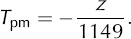
We assume the water cavities to be in steady state, in which case T B = T pm and z is the measured ice thickness. A mean annual ice-sheet surface temperature of −57.3°C was adopted by the Dome-F Ice Core Research Group (1998) for the Dome Fuji area (subglacial cavities 88, 89, 92, 93, 96 and 97). For subglacial cavities 146–172, surface temperature was assumed the same as at Vostok station, −56.8°C (Reference Lipenkov, Shibayev, Salamatin and EkaykinLipenkov and others, 2004). We used the mean surface temperature at Komsomolskaya (−52.6°C) for subglacial cavity 173, that at Pionerskaya (−38.1 °C) for subglacial cavity 174 (Reference Lipenkov, Yekaykin, Barkov and PursheLipenkov and others, 1998) and values from the Atlas of Antarctica (Reference BakaevBakaev, 1964) for all other subglacial cavities.
The mean annual surface accumulation rate was adopted from Reference Hondoh, Shoji, Watanabe, Salamatin and LipenkovHondoh and others (2002) for the Dome Fuji area (3.2 cm a−1). Data from Reference Lipenkov, Yekaykin, Barkov and PursheLipenkov and others (1998) and Reference Popov, Kharitonov and ChernoglazovPopov and others (2003, 2004) were used for the water cavities around VSL and along the Mirny–Vostok traverse route. Data from Reference BakaevBakaev (1964) were adopted for other cavities.
The mean snow surface density, ρ S, was used to convert the mean annual surface accumulation from g cm−2 a−1 to m a−1. This was adopted from Reference Lipenkov, Yekaykin, Barkov and PursheLipenkov and others (1998) for subglacial lakes 146–176. We assume the snow density in the VSL area to be the same as at Vostok station (Reference Popov, Kharitonov and ChernoglazovPopov and others, 2003, 2004). Following Reference Lipenkov, Yekaykin, Barkov and PursheLipenkov and others (1998), the dependence of the snow density on the mean annual surface temperature for subglacial cavities 85–87, 90–91, 94–95 and 98–100 was used to estimate ρ S. These cavities are in two areas: T S ≤ −47°C (region I) and −47°C ≤ T S ≤ −30°C (region II) and the relationships are:

The mean continental geothermal heat flux, λgeo, of 54.6 mWm−2 was adopted from Reference Siegert and DowdeswellSiegert and Dowdeswell (1996). The excess heat flux over the mean value (δλ) was estimated as

The geothermal heat-flux estimations and the principal characteristics of the cavities are shown in Table 1.
5. Discussion
The geothermal heat-flux estimations are comparable with the estimates of Reference Hondoh, Shoji, Watanabe, Salamatin and LipenkovHondoh and others (2002) for the Dome Fuji area and Reference Siegert and DowdeswellSiegert and Dowdeswell (1996) for a general assessment. The heat-flux results presented in Table 1 are based on in situ measurements. The mean is ~56 mW m−2, i.e. about the same as the mean continental geothermal heat flux. Five subglacial lakes, three in the VSL area, KSL and PSL, have an additional geothermal heat flux of >10 mW m−2.
The geothermal heat fluxes calculated using data from Reference BakaevBakaev (1964) are not as reliable as the other measurements. They are generally higher than expected. Russian (Reference Popov, Sheremet’yev, Masolov and LukinPopov and others, 2003) and US (Reference StudingerStudinger and others, 2003b) data indicate maximum ice thickness in the VSL area, off the lake, to be about 3900 m, but ice basal melting does not take place. Therefore, the estimation based on Equation (1) and the glaciological data mentioned above limits the geothermal heat flux to <49 mW m−2. Thus, the excess heat over the subglacial lakes is about 20%.
The maximum measured ice thickness in the Dome Fuji area (Reference Popov, Filina, Soboleva, Masolov and KhlupinPopov and others, 2002) is about 4300 m. The geothermal heat flux in that region is expected to be about 35 mW m−2. Thus the excess heat over the subglacial lakes is about 40%.
Analysis of the ice thickness along the Mirny–Vostok traverse route shows that the geothermal heat flux for the KSL and PSL regions is about 70 and 88 mW m−2, respectively. This value is higher than expected, especially for PSL. Reference Salamatin, Smirnov and Sheremet’yevSalamatin and others (1982) calculated the temperature in the ice sheet along the flowline from Ridge B to Mirny. They obtained melting zones near Pionerskaya station at heat fluxes of 55–60 mW m−2. The model accounts for ice-sheet dynamics. Salamatin and others assume there is no extra geothermal heat under Pionerskaya, and that extra heat results from the ice motion.
Whatever the means, increased heat flux is observed under the newly discovered subglacial lakes. We suggest that a number of these subglacial lakes lie over deep faults because of increased mantle heat. This result might be of interest in understanding the tectonics and formation of the continent.
6. Conclusion
We have (1) announced the discovery of 16 subglacial lakes in the areas near Domes Fuji and Argus and Prince Charles Mountains, (2) announced the discovery of 29 subglacial lakes in the VSL area and 2 between Vostok and Mirny, (3) analyzed RES results indicating a local subglacial river or fiord, probably connected to VSL, (4) estimated geothermal heat flux in the subglacial lake regions and (5) proposed that additional mantle heat may be contributing to ice melt in the subglacial lakes.
Acknowledgements
The fieldwork utilized for this study would not have been possible without the logistic support of the Russian Antarctic Expedition. For fieldwork assistance we thank A.S. Semenov, A.A. Vinogradov, V.M. Vinogradov, A.B. Dan’yarov, V.G. Rynkovenko, A.A. Korneev, V.R. Voronin, S.N. Gorshkov, R.Z. Haybullin, Yu.B. Chernoglazov, V.V. Charitonov and A.M. Enaliev. We thank T. Hondoh, A. Ekaykin, O. Soboleva and G. Burns for comments and corrections. We thank T.H. Jacka, G.K.C. Clarke and anonymous reviewers for helpful criticism and suggestions.



