


The early 1960s were tumultuous in South Asia. Following an Afghan force's invasion of West Pakistan in 1960, Pakistan and Afghanistan had only just normalized their political relations when war broke out between Pakistan and India. Muslim guerrillas, and later Pakistan Army forces, invaded Indian-controlled Kashmir in 1965; Indian forces retaliated by invading Pakistan and marching toward Lahore. While an uneasy peace was quickly enforced, the region was shaken. In the course of six years, Afghan armed forces had crossed into Pakistan, Pakistani forces into India, and Indian forces back into Pakistan. The series of events shared a key crucible: contested borders, with “national” sovereignty at stake. Specifically, the Kashmir dispute and Afghan refusal to recognize the Durand Line as an international boundary unhinged regional relations and created internal insecurities.
Sovereignty and borders have been key concerns across the humanities and social sciences during the past two and a half decades, particularly in the analytical deconstruction of “classical” nation-states (Agnew Reference Agnew1994). International relations theorists have shown that sovereignty does not “naturally” belong to states, national or otherwise (Elden Reference Elden2006; Herbst, McNamee, and Mills Reference Herbst, McNamee and Mills2012; Stepan, Linz, and Yadav Reference Stepan, Linz and Yadav2011). Instead governments must actively construct sovereignty through the arrogation of exclusive rights—making laws, minting money, administering justice, coercing—thus positioning themselves to be recognized as equals by the governors of other states and acquiring the ability to participate in the international system (see Barkin and Cronin Reference Barkin and Cronin1994; Fowler and Bunck Reference Fowler and Bunck1996; Gould Reference Gould2012). Territoriality—the ability to enforce a writ over a particular geographical space or spaces—plays a key role in this conception of modern statehood (Maier Reference Maier and Rosenberg2012). If states require a bounded territory in which to exercise authority, then the edges of these territories could be read simply as sites where sovereignty ends. In practice, state boundaries serve as sites for the performance of sovereignty. Militarized border landscapes, customs and passport controls, and the regulation of border traffic and immigration all highlight the policing of movement in and out of a state's domain as part and parcel of asserting sovereignty. Consequently, borders, their formation, and their regulation have attracted a great deal of scholarly attention (Agnew Reference Agnew2008; Bruslé Reference Bruslé2013; Häkli Reference Häkli, Cox, Low and Robinson2008; Wilson Reference Wilson and Nonini2014).
Imperial histories have demonstrated the complicated relationship between colonial sovereignty and border-making (Baud and Van Schendel Reference Baud and van Schendel1997; Blom Hansen and Stepputat Reference Blom Hansen and Stepputat2006). Borders circumscribed spaces where the colonial state ostensibly could and should manifest its rule and apply its visions of modernity. Certainly, however, this was not a straightforward narrative. The drawing of borders created not only cartographical and territorial problems—particularly when lines on maps only vaguely followed logical geographical or ethnographic contours—but also issues in citizen-state relations. Indigenous populations had little reason to recognize these newly drawn boundaries, though borders increasingly created opportunities to negotiate with or subvert the colonial state, complicating imperial projects (see Scott Reference Scott2009 for a southeast Asian example). Decolonization historiography demonstrates that when empires ended, they by no means left colonial borders and modern nation-states as their inevitable successors (Collins Reference Collins2013; Cooper Reference Cooper2014; Haines Reference Haines, James and Leake2015). Schemes for federation and other devolved sovereignty arrangements competed with nationalist movements, which demanded territorial states as the European empires crumbled after the Second World War.
In South Asia, an important arena for decolonization and postcolonial politics, both historians and geographers have highlighted the complicated nature of state-building and its associated social and political production of borders and nationalized spaces in the wake of the subcontinent's 1947 partition. While older work on partition focused on anti-colonial nationalism, Muslim separatism (Robinson Reference Robinson1974), and the postcolonial construction of nation-states (Jalal Reference Jalal2014; Khilnani Reference Khilnani1997), such work recognized but did not problematize borders. More recent works have highlighted the territorial concerns of partition, especially the role of territory in pre-partition Muslim political imaginations and the difficulties that accompanied the drawing of the Radcliffe line that ultimately divided India and Pakistan (Devji Reference Devji2013; Dhulipala Reference Dhulipala2014; on the boundary commission, see Chester Reference Chester2009). In recent years, borderlands and partition studies have intersected. In crucial work, Van Schendel has demonstrated how South Asian states and their representatives trying to “inscribe the border in the landscape” faced failure as a result of local geographies and resistance from communities (non-state actors) (Van Schendel Reference Van Schendel2004, 16). Scholars have emphasized the lived experiences of people who traverse borders, or whose paths borders block, particularly in the case of the mass migrations across the newly drawn Radcliffe line and refugees crossing between East Bengal (later Bangladesh) and West Bengal and India's northeast (Chatterji Reference Chatterji1999; Cons Reference Cons2013; Hussain Reference Hussain2013; Jones Reference Jones2009; Zamindar Reference Zamindar2007). Beyond Van Schendel, few scholars have united the theoretical perspectives of borderlands literature with studies of elite postcolonial politics.Footnote 1
This article therefore examines the role of centralized governing authorities in the production of discourses linking sovereignty, territory, and border-making. Sovereignty is not a given. Borders are not simply, or simple, dividers between geopolitical blocs. Seeing how policymakers in postcolonial states such as Pakistan and India (and even Afghanistan, whose history was indelibly linked to that of colonial India, despite never officially belonging to the British Empire [Hopkins Reference Hopkins2008]) made territorial claims, articulated the relationship between “community” and sovereignty, and envisioned their nations improves our understanding of the politics and ideologies behind postcolonial state-making. This article shows that when elites attempted to impose sovereignty on space and borders on territory, they treated these acts of sovereignty-making and border-construction as part of a natural, inevitable process through which the post-WWII world was zoned into nation-states, despite the fact that these policies often conflicted with, or were undermined by, lived realities of borderland inhabitants.
Van Schendel and Abraham (Reference Van Schendel and Abraham2005) have argued that the political and geographic limits of sovereignty inherent to borderlands imply the presence of competing authorities. We take a regional comparative approach to the issue of South Asian sovereignty and border-making in the aftermath of decolonization to demonstrate that South Asian state actors largely refused to recognize competing authorities, strictly maintaining the paramountcy of the state up to its borders. The study of South Asia's post-independence regional relations has largely focused on moments of conflict and upheaval, such as partition in 1947 and the secession of Bangladesh in 1971. But border disputes were ongoing and had widespread ramifications for almost all South Asian countries and their relations with each other and their neighbors. This article seeks to integrate histories of Pakistan, India, and Afghanistan—countries that have rarely all been considered in one analytical frame. It thereby highlights similarities and differences between these three countries, which share common legacies of engagement with British colonialism, but which have followed very different postcolonial trajectories. To do so we analyze two disputes, which, between them, spanned three countries: first, the India-Pakistan dispute over Kashmir; second, the contest between Pakistan and Afghanistan for control of the ethnically Pashtun-dominated North-West Frontier Province (NWFP) and “tribal” zone (otherwise known as “Pashtunistan”). Our study demonstrates not only the complexity of regional geopolitics, but also the convergences and divergences in the ways that state representatives attempted to assert their sovereignty in border zones (see figure 1).
South Asia in regional context. Illustration by Elisabeth Leake and Daniel Haines.

While the Kashmir dispute perhaps is better known, both disputes greatly influenced the development of regional relationships in South Asia from the moment of independence. The ceasefire line in Kashmir (now known as the Line of Control) and the Durand Line that separates Pakistan and Afghanistan were both subject to intense contest during the 1950s and ’60s, and both remain highly problematic today. India and Pakistan still dispute the status of Kashmir, while the “Af-Pak” borderlands provide the backdrop to transnational insurgency and cross-border drone strikes. Moreover, they represent two very different types of borders, as this article will show: along the Durand Line (much like the McMahon Line separating India's former North-East Frontier Agency from China-held Tibet), officials wrestled with colonial precedent. Kashmir's ceasefire line, in contrast, marked a completely new, largely arbitrary border that only emerged after 1947. Rather than analyze the two lines as sources of military conflict, this article demonstrates that governments in Pakistan, India, and Afghanistan have sought various ways to assert sovereignty without resorting to official violence.
This article therefore addresses the issue of sovereignty and borders in northwestern South Asia between the end of the British Raj in India in 1947 and the Indo-Pakistan war of 1965. While the solidification of previously fluid colonial frontiers into bordered, national zones may seem a logical given of the transition from empire to nation-state (Adelman and Aron Reference Adelman and Aron1999, 816), our analysis of South Asia reveals a far more complicated story of postcolonial state- and border-building that involved both reconciling the inherited complexities of colonial borders and grappling with the exigencies of newly drawn borders. Merely to accept that borders became more rigid ignores the moment in decolonization when borders were by no means certain and when the size, shape, and nature of the state and its peripheries were far from clear (see also Van Schendel Reference Van Schendel2002b). Van Schendel and Scott, among others, have highlighted the “plurality of identity repertoires” that exist among populations that live on the borders of the state (Scott Reference Scott2009, 255; Van Schendel Reference Van Schendel2004). This equally applies to communities in the Afghan-Pakistan borderlands and Kashmir, which, in the words of Marsden and Hopkins (Reference Marsden and Hopkins2011, 4), are “composed of a collage of interlinked and overlapping spaces” whose populations assume a variety of ethnic, social, political, and familial identities depending on their context. But critically, state actors frequently have resisted recognizing these multiple, entangled identities, instead promoting specific state-driven identities.
Border-making consequently created contradictions and hypocrisies for nation-state builders: in both Pakistan and India, political leaders did not follow one single logic of border-formation or recognition. Instead, border-making highlights the far more emotive, fraught processes by which colonial states became nation-states. Different logics underpinned sovereign territorial claims in different borderlands, and even these logics did not remain static.
In this article, we first examine the various justifications that leaderships in India and Pakistan used for their continuing involvement in Kashmir and its relationship to their national sovereignties. This is followed by commensurate propositions emanating from Pakistan and Afghanistan relating to the Durand Line. This comparison demonstrates that no consistent logic existed governing territorial claims in the region; the specific histories of the ceasefire line and the Durand Line drove leaders’ claims. Secondly, we show how the realities of state control in Kashmir and Pakistan's northwest frontier undercut such rhetorics of rule, drawing on examples of competitive economic development, governing structures, and the material nature of each line to argue that their actual effects on people living in those regions were highly contingent. There is, therefore, no ready way to characterize “borderlands” as a singular type of sovereignty arrangement: every border is unique. Yet we show how border settlements highlighted the anxieties of postcolonial state-making, and how new states actively worked to ensure their presence was felt in regions that had once been considered peripheral. Nationalist rhetoric, development, relationships of governance, and the militarization of landscapes were all key to the performance and institutionalization of sovereignty.
Material for this article is drawn from multiple archives in several countries and Indian and Pakistani national newspapers. The Indian and Pakistani archives both present the perspectives of bureaucrats and politicians, usually located in cities well away from the borderlands they wrote about. However, this is not to say that the archives present homogenous viewpoints. Official correspondence reveals discussion, dissent, and the dynamic nature of border policy-making. While we are not able to access the views of officers or civilians living “on the ground” in border zones, a direct comparison of Indian and Pakistani official discourses on postcolonial borders has not, to our knowledge, been attempted before. To address the many gaps and silences in South Asian archives, not least the unavailability of Afghan sources, we have consulted diplomatic archives in the United States and United Kingdom.Footnote 2 Western documents reveal discussions about South Asian borders in the State Department and the Foreign & Commonwealth Office. These are rich and valuable, due to both countries’ strategic interests in the region, if not always well-informed. More importantly, diplomats stationed in India, Pakistan, and Afghanistan continually spoke with national officials and reported back their words. The ways that South Asian leaders framed their problems and actions to foreign interlocutors reveals the images that they wished to project. Each source shows various biases—whether in terms of anti-Indian or anti-Pakistani rhetoric in the Pakistan and Indian archives, respectively, or an orientalist assumption of “tribal” backwardness in the British and US sources—but consulting a variety of source bases enables us to make a reasonably assertive argument.
Moreover, prioritizing the “top-down” perspective of official archives enables us to escape the assumption that borders look “fluid” at the periphery but “fixed” from the center. This perspective enables us to test scholarly border theory, largely formulated in the context of ethnographies of everyday borderland lives, against historical examples of state-driven territoriality. As we will show, the presumed fluidity and fixity of borders were characteristics that elite, central policymakers deployed as they sought to make and remake national territories.
Rhetorics of Control
Indian and Pakistani policymakers clashed in their visions for border-making in Kashmir, differing in their interpretations of the relationship between state sovereignty and territoriality. Under the terms of independence, the rulers of pre-1947 India's Princely States, such as Jammu and Kashmir, were given the option to choose integration into India or Pakistan, or remain autonomous (as were Pashtuns, politically identified as “tribal” in what became northwest Pakistan). For Kashmir, which was contiguous to both countries and which had a Hindu ruler but a largely Muslim population, the choice was not clear-cut. The state was historically a buffer between the British Raj and its rival empires—Russian and Chinese. Despite a history of conquest from the plains, particularly the Mughals, Afghans, and Sikhs (in the sixteenth, eighteenth, and nineteenth centuries, respectively), Kashmir was not historically integrated into lowland state-building projects. It had a distinct tradition of autonomy (Zutshi Reference Zutshi2015). Yet, as a relatively recent polity, it also lacked the cultural cohesion that characterized other upland areas, such as “Zomia,” the highland zone of Southeast Asia that encapsulated a distinct cultural and political identity for residents who were nevertheless split between multiple states (see Van Schendel Reference Van Schendel2002a).Footnote 3 As the transfer of power approached, therefore, Kashmir's place in subcontinental geopolitics was unpredictable. The Indian National Congress (representing India) and the Muslim League (representing Pakistan) developed ideological and strategic interests in the state (Copland Reference Copland1991, 47–67; Talbot Reference Talbot1998, 113–14).
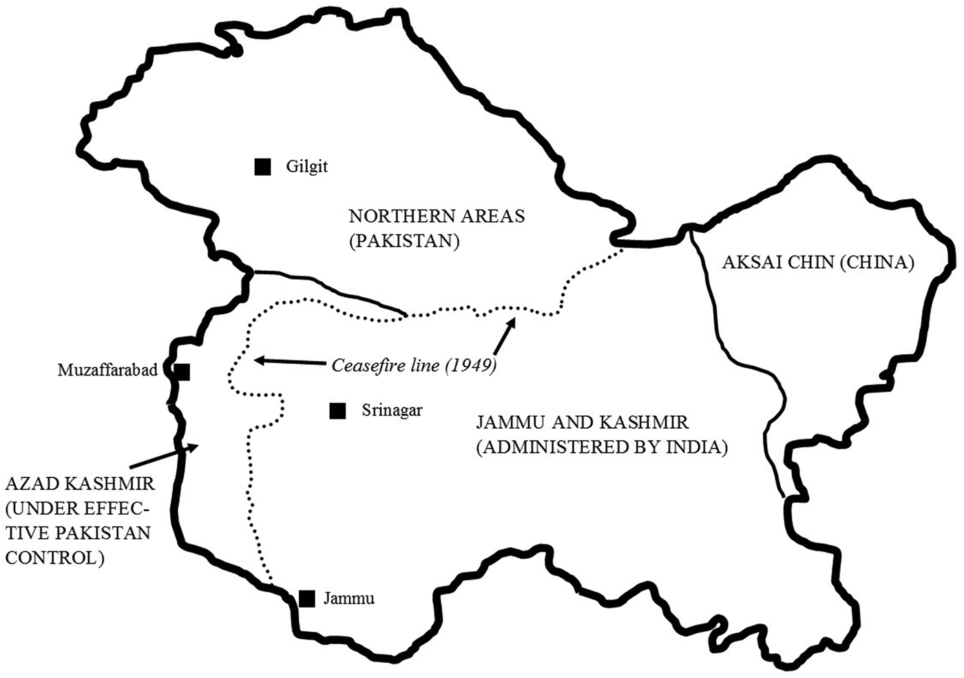
After the British ceded power in the subcontinent on August 14–15, 1947, Maharaja Hari Singh prevaricated over whether to join India or Pakistan, or attempt to remain independent. Muslims in Poonch, western Kashmir, rebelled against the maharaja in the same month. They received arms, aid, and eventually reinforcements from tribesmen from Pakistan's northwest frontier (and low-level Pakistani officials). The maharaja signed an Instrument of Accession to India on October 26 in order to receive military aid (Gupta Reference Gupta1966, 111–24). In May 1948, Pakistani regular forces began formal operations in Kashmir. Fighting finally ended between Indian and Pakistani troops in January 1949, when the United Nations imposed a ceasefire (Schofield Reference Schofield1996, 119–60). The ceasefire line, which separated Indian and Pakistani troops, has since formed a de facto border between Indian-held and Pakistan-held territory (see figure 2).
Divided Kashmir. Illustration by Elisabeth Leake and Daniel Haines.

Neither Indian nor Pakistani authorities considered the ceasefire line to be a permanent border, merely a convenient point to halt the fighting (Times of India 1949). The distinction is important. As Taylor (Reference Taylor1994) has argued, in the modern international system, the border is assumed to circumscribe a territorial state that acts as the “container” of a national polity, economy, and culture. The ceasefire line's lack of status as a legal boundary indicated that neither side considered any part of Kashmir's territory to be a part of the other's domain. Indeed, leaders from both countries presented conflicting interpretations of Kashmir's sovereignty: on one hand were Indian and Pakistani justifications for continuing interventions and influence over the state (usually involving the entirety of Jammu and Kashmir), and on the other was the issue of Kashmiri self-determination. These perspectives frequently came into conflict. Yet the ceasefire line's existence increasingly colored Indian and Pakistani approaches to Kashmir's future. As much as both states claimed that the line was a temporary measure, they increasingly expressed rigid notions of it as a border separating Indian and Pakistani zones of influence—and consequently spoke of the two divided regions of Kashmir as different wholes. In practice, if not in theory, the line looked increasingly like the edge of a state-container.
Fraught relationships between notions of sovereignty and the material line of control that divided spheres of authority provoked inconsistent Indian and Pakistani governmental positions on the meaning of Kashmiri self-determination. While the possibility of a plebiscite to enable Kashmiris themselves to vote to join India or Pakistan was first suggested in October 1947, successive UN efforts to bring it about have failed (see Panigrahi Reference Panigrahi2009, 92–98). One reason was the Indian leadership's insistence on a distinction between the Indian- and Pakistan-administered parts of Kashmir. Because Indian leaders claimed that the accession to India in October 1947 was legally binding, they viewed the whole as an integral part of Indian territory (Kashmir in the Security Council 1952, 48). In 1955, Pandit Govind Valabh Pant, India's Home Minister and Minister for States, claimed that the Kashmiri people had already declared their wish to integrate into India through their support for the National Conference, the state's ruling party (which was closely allied to the Congress Party in New Delhi) (NARA 1955b). The ceasefire line here figured as a divider between “Indian” and “Pakistani” spaces, with particular characteristics attributed to each side. As one Indian newspaper put it, “It is in so-called Azad Kashmir … that tyranny reigns – not on the Indian side of the cease-fire line where the indigenous Kashmiris rule” (Times of India 1957).
In 1957, an Indian Ministry of External Affairs briefing further argued that while India respected the principle of self-determination, it applied only to whole nations, not to parts of one such as Kashmir. Treating Kashmir as divisible from India would, the briefing claimed, “mean the breakup of its [India's] sovereignty and territorial integrity, which it is the purpose of the United Nations to uphold” (NAI 1957). Here the ministry was addressing a key debate in the UN: could the principle of self-determination extend to parts of existing states (see Mazower Reference Mazower2009)? By arguing that it could not, Indian leaders evoked a classically Westphalian notion of borders. To them, the ceasefire line fenced in an Indian national space. Despite the Indian government's consistent claim that Pakistan's presence in Azad Kashmir was an affront to India's legal ownership of the whole region, in practice it treated the division as finite. Nehru even suggested at one time a formal partition of the state reflecting that enacted by the ceasefire line (UKNA 1949).
In contrast, the Pakistan government invoked the right of all Kashmiris to self-determination—often finding echoes in the national press, as when in 1957, Dawn reported information “coming from across the cease-fire line” that Kashmiris on the Indian side were holding widespread popular rallies in favor of a plebiscite (Dawn 1957b). The Pakistan government supported Sheikh Abdullah's calls for a Kashmiri plebiscite. For example, in 1958, the chief minister of West Pakistan, Muzaffar Ali Khan Qizilbash, publicly claimed that Indian authorities intended to rearrest Shaikh Abdullah to deny Kashmiris the right of self-determination (NARA 1958). At least in diplomatic discussions, Pakistani officials continued to refer to Kashmir as a whole that needed to be reunited, though in practice, as we shall see, official focus remained on Azad Kashmir.
Neither Pakistani nor Indian discourses made reference to the interests or views of Kashmiris themselves. Like the drawing of the partition boundary in Punjab and Bengal in 1947, there was little room in elite imaginings of sovereignty for the complexity of borderland identities. In Kashmir, border-making was a top-down process. The nature of the border, and the characteristics of political space on either side, resulted from the tensions between formal sovereignty claims and de facto, militarized power.
The dispute between Pakistan and Afghanistan over the Durand Line separating the two countries differed significantly from the dispute between India and Pakistan over their respectively held areas of Kashmir. Unlike the arbitrarily drawn ceasefire line, the Durand Line had historical roots. It was established in 1893 by the British negotiator, Sir Henry Mortimer Durand, and Afghanistan's Amir, Abdur Rahman Khan, based on territorial and strategic concerns. Like Kashmir's ceasefire line, however, its placement was subjective: for example, it split Waziristan, the homeland of local Wazir Pashtuns, between the two states, ensuring a boundary that did not match local ethnic and cultural realities, a point addressed in the next section (Omrani Reference Omrani2009, 185). Critically, the 1893 agreement never made clear whether the Durand Line should be considered an international boundary or a less formal frontier. Treaties between Amir Amanullah Khan and British officials following the 1919 Anglo-Afghan War, however, seemed to confirm that the Afghan government recognized the Durand Line as delimiting the Afghan state (Haroon Reference Haroon2011, 107).
Unlike Kashmir's ceasefire line, which neither Indian nor Pakistani representatives accepted as a “real” border, the Durand Line was recognized by Pakistan and rejected by Afghanistan. Pakistani officials adhered to the precedent of the 1893 and 1919 legal agreements between their British colonial predecessors and Afghan representatives. Afghan leaders claimed that these colonial-era procedures had not actually defined the Durand Line as an international boundary. The transfer of power created new opportunities for Afghanistan. Like India and Pakistan, Afghanistan was also transforming. Starting in the late 1940s, the royal family pursued foreign economic aid while taking slow steps to liberalize governance and modernize Afghanistan's society and economy. With decolonization, officials saw an opportunity for political and territorial expansion. Ethnic Pashtuns of Pakistan's NWFP and autonomous tribal zone shared ethnic, cultural, and social ties with the large Pashtun population in Afghanistan. The Afghan ruling family itself was ethnically Pashtun, and still provided financial allowances to tribes on both sides of the Durand Line.
Afghan officials grew determined to influence Pashtuns’ decisions about their future, particularly as British negotiations made clear that tribal Pashtuns could enter new treaties with their neighbors upon independence. As with Princely States like Kashmir, the tribal areas of northwest and northeast colonial India were not part of directly British-ruled India; instead they had longstanding treaty arrangements that were intended to keep local tribes quiescent and nominally attached to the Raj (Ali Reference Ali1990, 94). In June 1947, Afghan leaders demanded two alternatives: an “immediate statement that [Pashtuns] are free to choose independence” or the opportunity for an Afghan mission to participate in the transfer-of-power negotiations. The governments in London and Delhi refused (Ali Reference Ali1990, 97–100; Mansergh and Moon Reference Mansergh and Moon1982, 377). As independent Pakistan materialized, India's colonial government could hardly make an agreement that undermined the new state before it even gained autonomy (or set a precedent for other secessionist movements across South Asia). If the British had consented, Pakistan would have crumbled, its geographical presence shriveling. The Afghan Minister for Foreign Affairs nevertheless maintained, even after the British announced their plan for withdrawal and partition, that the area between Peshawar and the Jhelum River (which flows through Punjab) “formed the original and permanent abode of the Afghan race” (Ali Reference Ali1990, 102).
Afghan demands subsided briefly in late 1947, but shortly after Pakistani independence, Afghan officials approached the Government of Pakistan concerning the future of the Pashtuns.Footnote 4 In 1948, Najibullah Khan, the Afghan special envoy, provocatively submitted a treaty demanding autonomy for Pakistan's “Afghans” (meaning ethnic Pashtuns) and a redefinition of the Afghan-Pakistan border, as the Afghan state refused to recognize the Durand Line (NAI 1948). To this, Pakistani leaders replied, “Pakistan would respect [tribal, though not provincial, Pashtuns’] independence and that she never wished to bring military or non-military pressure to bear on them” (NAI 1948). The statement seemed to imply that Pakistan would accept some limited form of sovereignty at the Durand Line, pointing toward a more complex model of state space than the simple inside/outside distinction that underpins the assumptions of the modern international system (see Walker Reference Walker1993). Najibullah took this statement—and further talks with Pakistan's Governor-General Muhammad Ali Jinnah—to mean that the Government of Pakistan agreed with the Afghan position and would allow self-determination for Pakistan's Pashtuns. His perspective reflected the assumption that rather than the border separating zones of authority, the supposedly “Pashtun” ethnic characteristics of space and territory would produce an appropriate (trans)border regime. In his conception, Pakistan's Pashtun population meant that an ethnically defined space or zone, rather than a line, separated Afghanistan and Pakistan (on scales of borderlands spatiality, also see Van Schendel Reference Van Schendel2004, 7–8; on statist conceptions of space underpinning border-formation, see Elden Reference Elden2010).Footnote 5
Pakistani officials refuted this with their attachment to the Durand Line. Foreign Minister Zafrullah Khan, ironically echoing Indian Home Minister Pant's pronouncement on Kashmir, declared, “The tribes of the North West Frontier have contributed in a great measure toward the achievement of Pakistan and when this new Islamic state was set up they expressed their firm determination to join it…. They will have the same self-Government as any other part or province of Pakistan” (NAI 1948). Prime Minister Liaquat Ali Khan pointed to the 1947 referendum that led the NWFP to join Pakistan, as well as the new treaty arrangements between tribes and the state, calling the locals “good Pakistanis”: he overlooked that many in the province had boycotted the referendum—so its outcome did not necessarily represent local sentiment—as well as locally rooted ethnic, social, or tribal identities that likely mattered more than being supposedly “Pakistani” (Ali Reference Ali1990, 139). Officials were loath to give up the northwest frontier, tribes and all, which comprised a significant geographical space within Pakistan.
Afghanistan's continued demand for “Pashtunistan”—a Pashtun homeland—dominated relations with Pakistan (see figure 3). Particularly under Prime Minister Mohammad Daoud Khan, Afghanistan refused to recognize the Durand Line, leading to border clashes and diplomatic incidents between the two countries throughout the 1950s and into the 1960s. The Government of Afghanistan published a map in 1959 that delineated the “maximum area involved in Pashtoonistan,” incorporating large swathes of Pakistan. Pakistani officials deemed this an “unfriendly act” (NARA 1959). In September 1960, plain-clothed Afghan army forces and tribesmen crossed into Pakistan, only to be repulsed by the local population (NAI 1960). At the state level, this led to a diplomatic and economic impasse, which only ended in 1963 after Daoud was forced to resign as prime minister (NAI 1964; Saikal Reference Saikal2012, 132).
The shaded area represents the Pashtunistan claim on Pakistan-administered territory. Illustration by Elisabeth Leake and Daniel Haines.

Seeking to undo the colonial-era Durand Line, Afghan leaders consequently sought other justifications for their interest in Pashtunistan and arguments against the recognition of Pakistan as the legal heir to British colonial treaties. The Afghan Government rationalized its continuing interventions across the Durand Line in ethnic terms, calling upon a shared Pashtun heritage. Based on what Anthony Smith (Reference Smith1996) has called the “territorialization of memory”—here, remembrance of a common Pashtun history and homeland—the Afghan government sought the creation of a Pashtun “ethnoscape” (see also Schetter Reference Schetter2005). The long history of Pashtun residence outside the extant Afghan state, and the longstanding problems of Afghan rulers in extending authority throughout the country, complicated Kabul's conflation of Afghan and Pashtun identities. Yet Afghan government use of the term “Afghans” in demands for Pashtun autonomy pointedly and directly associated transborder Pashtuns with the Afghan state. Broadcasts from Kabul Radio focused on their shared heritage with Afghanistan. “How painful it is,” one broadcast went, “that the land of our forefathers is being ruled by foreigners today. Come let us unite and win back our honour and prestige from the foreigners. Come let us recall our past and compare it with our present” (NARA 1955e).
In contrast, Pakistani leaders worked on the assumption that they had inherited the Durand Line as an international border. In a meeting with the Afghan Foreign Minister in Peshawar, Pakistani reporters demanded to know why Afghanistan refused to recognize Pakistan as the legal successor to British rule (Ali Reference Ali1990, 241–42).Footnote 6 In the case of the Durand Line, Pakistan took a classic modernist approach to borders as “dividers between geopolitical blocs,” and referred to these colonial-era lines as international boundaries (Häkli Reference Häkli, Cox, Low and Robinson2008, 471).
However, this same logic could not be applied in the case of Kashmir. The nature of the ceasefire line and the mode of its creation marked a sharp distinction from earlier processes of border-making in South Asia. The ceasefire line was not intentionally created to demarcate Indian and Pakistani spheres of influence, although this is what it came to represent. It created an artificial borderland within the former princely state of Kashmir, despite continued Indian and Pakistani claims regarding the entire state. Neither Pakistan nor India could draw upon colonial precedents to justify their claims. They instead turned to international law, and more emotively to religion and identity. Ironically, Pakistani leaders’ continued demand for a plebiscite and “self-determination” for Kashmiris mirrored Afghanistan's claims for autonomy for Pakistan's Pashtun population. Faced with a new borderland through Kashmir, Indian and Pakistani leaders could not turn to the same border logics as they did when facing irredentist claims to the Durand or McMahon Lines.
Indeed, the zero-sum nature of competition between the various rhetorics of sovereignty in play meant that it was difficult for all countries involved in the Kashmir and Pashtunistan disputes to find common bases for negotiation. Neither the process of decolonization nor any coherent theory of state sovereignty produced a consistent set of territorial dynamics in South Asia. While state sovereignty, as enshrined in the UN Charter and quoted by India's Home Minister, hypothetically dictated the formation and recognition of self-determination within national boundaries, in practice these theories (then and now) did not result in any single logic for border formation or adherence. This paradox, however, did not stop either Pakistan or India from attempting to put rhetoric into action. On either side of the ceasefire line and up to the Durand Line, Indian and Pakistani officials worked to match their sovereign claims with the territorial space of the nation.
Practicalities of Control
Despite the arguments made by Indian, Pakistani, and Afghan officials regarding the future of Kashmir or the Durand Line, matters on the ground complicated putting espoused policies into practice. Indian and Pakistani leaders may have spoken of a united (either Indian or “free”) Kashmir, but in practice, their policies cemented the ceasefire line into a hard border between Indian and Pakistani domains (Ayub Khan's ill-fated bid to invade Indian-held Kashmir in 1965 notwithstanding). Development initiatives and governing relationships distinguished Indian-held from Pakistan-held Kashmir. These twin elements had an equally telling impact along the Durand Line, where Pakistani officials focused on development as a mode for integrating the tribal area and making “Pashtuns” “Pakistani.” Afghanistan, in contrast, lacked the funds to pursue similar development plans. But Afghan leaders continued to extend political and limited financial relationships across the Durand Line into Pakistan's autonomous tribal areas, thereby undermining Pakistan's economic-driven actions.
These differing forms of competition meant that communities in Pakistan's tribal area could maintain relationships across the border, benefit from interacting with both states, and effectively ignore the Durand Line. In essence, while Pakistani and Indian competition in Kashmir made a previously theoretical border into fact, Afghan and Pakistani competition along the Durand Line undermined its already fragile nature, reflecting a local reality where neither country was truly sovereign over the local population, despite the presence of an international border.
Development was a key way in which the Indian and Pakistani states attempted to demonstrate materially their claims to sovereignty. Outside contested areas such as Kashmir and Pakistan's tribal areas, development in 1950s South Asia predominantly meant large-scale schemes to improve infrastructure, heavy industry, and import-substitution manufacturing (see Cullather Reference Cullather2010; Roy Reference Roy2007). In Pakistan, development schemes were similarly important to rulers’ images of legitimacy (see Daechsel Reference Daechsel2015). Afghanistan lagged behind, only completing several moderately successful five-year plans with the help of Soviet financing and technical expertise (Cullather Reference Cullather2010, chap. 4; Leake Reference Leake2017).
In Kashmir and along the Durand Line, development activities took on additional resonances. India's First and Second Five-Year Plans, the calling-cards of Nehruvian developmentalism, included Kashmir (Rushbrook-Williams Reference Rushbrook-Williams1957, 26). Indian official correspondence discussed developing water resources in Jammu and Kashmir (NAI 1954b). Similarly the Pakistan government's actions in Azad Kashmir, including building the Mangla dam at Mirpur starting in the late 1950s, exercised de facto sovereignty. Islamabad pressed ahead with the project despite significant opposition from local residents, disregarding supposed Kashmiri self-determination. In July 1957, for instance, a public meeting in Mirpur passed a resolution demanding that a plebiscite on the future of Kashmir precede construction work on the dam. Some residents observed a partial hartal, or boycott of shops and businesses. The Pakistan and Azad Kashmir governments responded by calling further public meetings in order to put across pro-dam perspectives (NDC 1957b). Nevertheless, dam work progressed. Pakistan's Ministry of Kashmir Affairs also promoted smaller-scale development projects such as agricultural extension and forestry (NDC 1957a). Such initiatives performed Pakistani custodianship over Kashmir to Pakistani as well as Kashmiri audiences, as Radio Pakistan's promotion of “the progress made in the development of Azad Kashmir, specially in the fields of education and health” suggested (Dawn 1957a). The ceasefire line dividing Indian and Pakistani development activities in Kashmir, while officially temporary, in practice served as a border separating two sovereign powers.
Development was equally important along the Durand Line (for an Indian comparison, see Guyot-Réchard Reference Guyot-Réchard2013). Pakistani officials sought to strengthen ties with the tribal zone and integrate the NWFP into the Pakistani state. Despite economic constraints after partition, the government took new steps to improve circumstances in both tribal areas and settled districts through developing roads, cottage industries, and agricultural initiatives (NAI 1954b). As the first Pakistani governor of the NWFP explained, “the greatest possible stress should be laid on the development schemes, which will result in lasting benefit for the tribal people … in the frontier region causing their permanent attachment with the State of Pakistan” (NDC 1952). Specifically referring to the ongoing dispute with Afghanistan, the Secretary to the Government of West Pakistan, Tribal Affairs Department, continued to believe that “if the economic standard of the tribesmen is raised, they will be less susceptible to temptation from outside” (NDC 1958).
Pakistani development efforts also forced the Afghan Government to follow suit; as one American official touring the frontier area reported, the Afghan Government would need “to do an equivalent amount for their own tribesmen in order to keep their loyalty” (NARA 1955d). But the extremely poor Afghan Government could not match the foreign aid pouring into Pakistan from the United States, even as it increasingly received support from the Soviet Union. The Indian Vice Consul in Jalalabad bemoaned, “The economic condition of the people is very poor…. If the Afghanistan Government or Pakhtunistan movement could remedy this malady, this area could be saved otherwise later or sooner, hunger would make the people submit to Pakistan which offers them better prospects” (NAI 1954a). The British Deputy Commissioner in Peshawar noted that alongside Pakistani development efforts, “the contrast with Afghanistan is becoming more evident to the tribesmen” (UKNA 1958). While Afghan leaders pursued limited road-building with Soviet aid, they did less to create economic opportunities west of the Durand Line. The line served as the limit to Pakistani development and in the starkest terms differentiated Pakistani from Afghan development capacities.
Revising governing relationships provided another means for potentially integrating these peripheral regions. Indian officials pursued political ties between Indian-held Kashmir and the rest of the country, though Pakistani leaders outwardly appeared more reticent, in part because of their official policy of supporting Kashmiri self-determination. Despite the Indian Constitution's provision of special, autonomous status for Jammu and Kashmir, India gradually incorporated the State through acts such as the abolition of customs tariffs in 1954 (Schofield Reference Schofield1996, chap. 11). Delhi's integrationist policies also included symbolic interventions. In 1963, the Indian Kashmiri leader, Bakshi Ghulam Mohammed, announced that Jammu and Kashmir's head of state and prime minister would be renamed governor and chief minister, respectively (NAI 1963). This move subordinated the state's administration to the Indian Union by removing symbols of autonomy. Taken together, these steps attempted to materialize the Indian leadership's rhetoric equating Kashmiri and Indian territory. The old border between the princely state and British India had dissolved; India claimed legal sovereignty over the whole former Jammu and Kashmir State but settled for de facto control of Jammu and the Valley.
In contrast, Pakistan claimed no formal ownership of Azad Kashmir, but a 1952 agreement between the Pakistan and Azad Kashmir governments enabled Pakistan's Ministry of Kashmir Affairs to veto legislation passed by the Azad Kashmir Council (Rushbrook-Williams Reference Rushbrook-Williams1957). The large number of Pakistani officials “on loan” to the Azad Kashmir government in policymaking positions, much like the building of the Mangla dam, also demonstrated that Pakistan's de facto sovereignty over the state contradicted its espoused support for an “independent” Kashmir (see Sneddon Reference Sneddon2011, chap. 4).
In contrast to these obvious attempts to link Kashmiri peripheries to the center, Pakistan took a more cautious approach to its northwest frontier. Pakistan's leaders rejected any policy that emphasized Pashtun (or other) ethnic difference within Pakistan. The central government refused in the early 1950s to consider renaming the NWFP “Pashtunistan,” as urged by the famous Pashtun anti-colonialist, Abdul Ghaffar Khan. Ayub Khan, once president, similarly rejected the idea of establishing a Pashtun administrative unit within West Pakistan: because of “the need to build up a wider national consciousness[,] there would be no such concessions to regional feeling” (UKNA 1960).
But despite Liaquat Ali Khan's reference to locals as “good Pakistanis” and the central government's statements that the frontier was firmly a part of Pakistan, in reality, officials did little to effect political integration. Besides the 1951 establishment of the Mohmand Agency, which introduced one additional Pakistani political agent in the tribal area, few other political projects were pursued. Pakistan's Secretary for Tribal Affairs explained that “the Government's policy was to bring social and economic progress to the people of the tribal areas, with the ultimate aim of bringing them up to the level of development of the rest of the country and, by implication, to make them full-fledged Pakistanis” (NARA 1955c). Officials did not, however, believe they could replace the local jirga system of governance—which left local councils to resolve disputes between and within tribal society—without facing widespread resistance (see Verkaaik, Khan, and Rehman Reference Verkaiik, Khan, Rehman, Kalir and Sur2012 on persisting legal differences between the tribal area and Pakistan's provinces). This contrasted sharply with the Pakistan government's frequent interventions into Azad Kashmiri politics, epitomized by the ease with which the Ministry of Kashmir Affairs dismissed the presidents of the nominally autonomous state six times between 1950 and 1959 (Sneddon Reference Sneddon2011, 90).
Unable to engage in any real economic competition with Pakistan, Afghan leaders instead turned to political organization to mobilize transborder Pashtun support. Afghan leaders organized frequent jirgas in the Eastern Provinces, as well as occasional larger meetings in Kabul, where they promoted support for Pashtunistan, anti-Pakistan action, and doled out small amounts of financial aid. Immediately preceding the Afghan army's failed 1960 intervention across the Durand Line, the Afghan governor in Jalalabad invited a large jirga from across the Durand Line to Nangarhar Province to reaffirm his support for Pashtunistan; he demanded “that [if] a number of nations had attained freedom then why not the brave tribesmen” (NAI 1959). Afghan leaders also organized more symbolic political events. “Pashtunistan Day” became an annual holiday celebrated in Kabul and other major Afghan cities, with parades and public broadcasts. Afghan leaders also helped the Faqir of Ipi, a mullah from Pakistan's tribal area and a key promoter of Pashtunistan, to design and produce a Pashtunistan flag.
Despite Afghan and Pakistani officials’ efforts to secure local loyalties through development or political activity, in practice this had little influence on the Durand Line's importance to the people who lived along it. Pashtuns in Pakistan's largely autonomous tribal areas continued to receive subsidies from both governments, and differentiating between tribes and tribal leaders who were “pro-Afghanistan,” “pro-Pakistan,” “pro-Pashtunistan,” or merely “anti-state intervention” was (and is) extremely difficult. Tribal skirmishes with Pakistani and Afghan armed forces occurred on both sides of the border. Officials in both countries maintained that they had tribal loyalty, but their reports inevitably clashed, undermining their plausibility. The Pakistani political agent in South Waziristan, for example, assured his government that “after all is said and done the fact remains that the Mahsud [Pashtun] is definitely Pro-Pakistan. Although individual Mahsuds can be bought by Kabul, their prudence will not allow them to indulge in serious activities against Pakistan” (NDC 1950). The Pakistani press carried regular reports of tribal jirgas demanding that Afghanistan stop interfering in the tribal zone (NAI 1953; NARA 1952a, 1952b).
In contrast, the Afghan press emphasized Pashtun resistance to Pakistani governance. In 1955, for example, the Afghan press reported on May 8 that a jirga of Pashtuns on the Afghan side of the border had condemned One Unit, the establishment of a unified West Pakistan. Local mullahs reportedly “expressed profound indignation and marched to nearby localities informing people no sacrifice [… was] too great to right this desecration” (NARA 1955a). Perhaps most telling, during the 1960 border conflict between Afghanistan and Pakistan, local lashkars, or war parties, in the autonomous tribal area fought against both Afghan and Pakistani forces. Autonomous tribal identities arguably had more influence on Pashtuns’ relationships with Afghanistan and Pakistan than either state cared to recognize. Despite a legal status (albeit disputed), the Durand Line counted for little.
The ceasefire line in Kashmir was the inverse of the Durand Line. Rather than an official but nominal boundary that development and governance relationships crossed with impunity, the ceasefire line divided Indian- and Pakistan-sponsored activities in Kashmir. As the Line of Control, it still forms the de facto border, running through approximately 500 miles of mainly mountainous country (Korbel Reference Korbel1953, 503). Kashmir was (and is) a distinctively militarized landscape, unlike the Durand Line where state military presences were irregular. UN observers were also stationed along the ceasefire line to check that no major violence occurred. According to one observer, India tended to treat its side of the line as a military area, whereas civilian agricultural activity on the Azad Kashmir side reached up to the line itself (Rushbrook-Williams Reference Rushbrook-Williams1957, 30).
As with the Durand Line, civilians were known to cross the line in both directions. In Kashmir, however, such transgressions drew fire from opposing soldiers (Lourie Reference Lourie1955, 29). The zone around the line was therefore a mix of military no-man's land and civil frontier. Such militarization could as readily affect civilians on “their” own side of the ceasefire line. The Pakistani daily Dawn claimed in 1962 that Indian military authorities had warned Muslims living on the Indian side of the line near Rampur and Chakoti “to keep military passes in their possession all the time to avoid [the] death penalty” (Dawn 1962). The possibility of movement across the border remained open: the boundary fence, extant today, did not exist before 2004. Yet because such movement disregarded the ceasefire agreement's implicit recognition of Indian and Pakistani spheres of authority, it carried grave risks. The ceasefire line, then, formed both the physical and symbolic division between Indian and Pakistani space far more effectively than did the Durand Line between Pakistan and Afghanistan.
Conclusion
The issue of territorial sovereignty and security had resonance across the broader decolonizing world, far beyond the Kashmir and Durand Line disputes. For many anticolonial leaders who became new national heads of state—not only in South Asia but elsewhere—territorial sovereignty was key. For the most part, they inherited the roughly drawn colonial boundaries, and sought to maintain and strengthen them as national spaces. A territorial presence also meant a seat in the United Nations and formal recognition from former colonial powers and fledgling postcolonial states. Borders dictated the spaces where new leaders could focus their development efforts, increasingly drawing on financial and technical support from the United States and the Soviet Union. In short, the territorially contained nation-state provided the space for leaders to create national identities and national projects, identifying those colonial inheritances they chose to keep, as well as those they eagerly terminated. Borders were crucial for denoting where one nation ended and another began.
However, border disputes complicated the process of state-building, and the territorial sovereignty accepted by one new nation was not necessarily recognized by others. These sovereignty disputes were evident in both South Asian case studies, as well as in other instances of decolonization. The Afghan government's claims to Pakistan's Pashtuns based on shared ethnicity clashed with Pakistan's territorial focus and continued reference to colonial precedence. India and Pakistan's justification for ruling the entirety of Kashmir conflicted with the realities of a divided state. Similar situations emerged in other areas of the decolonizing world, whether Korea, where the 38th parallel arbitrarily divided populations that shared ethnic, cultural, and familial ties into two states, much like Kashmir's ceasefire line; Cambodia and Laos, whose shared border haphazardly divided ethnic groups between the new countries; or the Congo or Nigeria, where irredentist communities attempted to draw new borders matching ethnic zones.
Decolonization and postcolonial state-building transmuted flexible, ill-defined colonial boundaries into firmer borders, often complicating relations between, and within, postcolonial states. Some new citizens did not acknowledge the sanctity of newly national borders, which did not match local livelihoods and preexisting subnational and transnational identities. But state officials frequently refused to recognize these alternative identities and pushed forward with initiatives that emphasized a unitary state-based polity. Understanding state sovereignty after decolonization must recognize that despite the importance of local identities, elite conceptions of borders have frequently been paramount in directing the ways states have addressed their borderlands populations.
Yet despite wider resonances of postcolonial border-making, the specific histories of the ceasefire line in Kashmir and the Durand Line conditioned their impacts on state sovereignty. The multiple and competing geographical imaginaries that characterized Indian and Pakistani claims on Kashmir turned the latter into a borderland on a much broader scale than those addressed in borderlands literature on other parts of South Asia. At stake in the Kashmir dispute was not sovereignty over relatively small areas of land near shifting riverbeds, regulation of human traffic across a boundary, or even enclaves of one state's territory buried inside the other. While Reece Jones (Reference Jones2011) has argued that movement across the India-Bangladesh border today demonstrates that neither “India” nor “Bangladesh” are fixed and finalized categories, Indian and Pakistani policy on Kashmir's ceasefire line demonstrated a dual concern to fix and stabilize de facto sovereignty while leaving open de jure possibilities such as plebiscites and partitions. The Durand Line, by contrast, figured in policy mainly because it could not circumscribe either local Pashtuns’ own movements and loyalties or the Afghan state's claims. The key difference was that of history: the aftermath of decolonization created a new border in Kashmir, but merely added another chapter to the long history of the Durand Line. Their specificity meant that states could not engage a single logic of sovereignty or governing rationale. Border drawing and ruling were contingent. Future work could usefully integrate other South Asian borders into a more fully trans-Asian perspective, for example the China-India and Bangladesh-Myanmar frontiers.
Nevertheless, we must recognize the extent to which these two borders featured in elite conceptions of state territoriality, despite the fact that lived realities in these borderlands did not match state-level perspectives. On a certain level, the fact that borders disrupted everyday lives—in the case of the ceasefire line in Kashmir—or were only lightly in place—as at the Durand Line—did not matter. As much as the Pakistani, Indian, and Afghan governments recognized borders’ potential for fluidity and uncertainty, their rhetorics and action only made sense so long as each state assumed that asserting (even limited) control over a given territory was a possible, desirable, even necessary, goal. The exercise of sovereignty, regardless of its logic but expressed through development and governance activities, required a bounded space that only borders could provide.
Acknowledgments
We would like to thank Sarah Ansari, Dane Kennedy, and the anonymous peer reviewers for draft comments, as well as the Leverhulme Trust and British Academy for funding the underlying research.