Introduction
The Cyrenaican Prehistory Project is investigating the history of climate, environment and human settlement in the Gebel Akhdar or ‘Green Mountain’ massif of Cyrenaica in north-east Libya over the past c. 150,000 years (150 ka), the approximate length of time that anatomically modern humans (Homo sapiens) are thought to have been present in North Africa (Garcea Reference Garcea2010; Hublin and McPherron Reference Hublin and McPherron2011). The project began in 2007 with sponsorship by and funding from the Society for Libyan Studies, which have continued ever since, but from 2009 the principal funding for the fieldwork and analytical programme has been from the European Research Council and within the terms of this funding the project is known by the acronym TRANS-NAP, standing for ‘Cultural Transformations and Environmental Transitions in North African prehistory'. The nature and scale – and success or otherwise – of human responses to changes in climate and environment are of particular interest in the context of three major episodes in North African prehistory. The first is the initial colonisation of the region by Homo sapiens, the first fossil evidence for which is c. 200 ka in East and South Africa, with their expansion into North Africa generally thought to be linked to humid climatic phases in Pleistocene climate, in particular Marine Isotope Stage 5 or MIS 5 dated to c. 130–74 ka, when there were lakes and rivers in the Sahara (Armitage et al. Reference Armitage, Drake, Stokes, El-Hawat, Salem, White, Turner and McLaren2007; Drake et al. Reference Drake, Blench, Armitage, Bristow and White2011; Garcea Reference Garcea2010; Osborne et al. Reference Osborne, Vance, Rohling, Barton, Rogerson and Fello2008). The second is the nature of human responses to the ensuing climatic instability of MIS 4–2: MIS 4 (c. 74–60 ka) and MIS 3 (c. 60–24 ka) were characterised especially by spatio-temporal variability in climate, culminating in an overall peak of aridity within the Last Glacial Maximum (MIS 2, c. 24–18 ka), which was followed by sharp climatic fluctuations associated with deglaciation processes leading up to the Pleistocene/Holocene boundary c. 11.5 ka. The third research area concerns the timing and routes of dispersal of plant and animal domesticates in the Early Holocene (c. 11.5–7.5 ka) and the timing and nature of the transition from hunting and gathering (foraging) to farming at this time, another period of marked climatic instability characterised especially by relatively humid conditions in the Early Holocene followed by the development of the present-day semi-arid climate in the Mid Holocene.
To address these questions the project has combined the re-excavation of the Haua Fteah cave with a programme of geoarchaeological survey across a transect of terrain that stretches for ~75 km southwards from the coast (where the Haua Fteah is located) over the Gebel Akhdar hills (which reach to just under 1000 m above sea level) to the edge of the Saharan desert (Jones et al. Reference Jones, Farr, Barton, Drake, White and Barker2011). The Haua Fteah is a dry shelter measuring ~80 m wide by ~50 m deep that faces north to the Mediterranean sea about a kilometre away. Between 1951 and 1955 the Cambridge prehistorian Charles McBurney conducted a major series of excavations in the sediments flooring the cave (McBurney Reference McBurney1967). He found a deep (~14 m) sequence of human occupation evidence, the beginnings of which he suspected might go back in date to the Last Interglacial, at that time thought to date to around 100 ka. (The only radiometric method available at that time for dating Pleistocene sediments was 14C or radiocarbon dating, and the techniques used are now understood to have generated unreliable age estimates >30 ka.) The sequence continued upwards more or less continuously through what he termed, using a European rather than African classification system, Middle Palaeolithic (Pre-Aurignacian followed by Levalloiso-Mousterian), Upper Palaeolithic (Dabban followed by Oranian), Mesolithic (Libyco-Capsian) and Neolithic (Neolithic of Capsian Tradition) levels, with this deep prehistoric sequence capped in the uppermost 1 m of the stratigraphy by occupation levels dating to the Graeco-Roman and post-Classical eras (McBurney Reference McBurney1967). The principal aim of the new investigation is to investigate the changing character of human activity through the long period that the cave was used, and whether such changes can be better understood in terms of responses to climate change or to cultural factors unrelated to this, or to combinations of environmental and cultural processes acting in tandem.
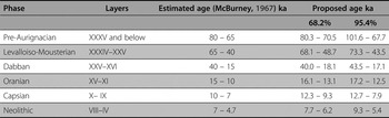
As the series of annual interim reports on the CPP/TRANS-NAP fieldwork and other papers have described (e.g. Barker et al. Reference Barker, Hunt and Reynolds2007; Reference Barker, Basell, Brooks, Burn, Cartwright, Cole, Davison, Farr, Grün, Hamilton, Hunt, Inglis, Jacobs, Leitch, Morales, Morley, Morley, Pawley, Pryor, Reynolds, el-Rishi, Roberts, Simpson, Twati and van der Veen2008; Reference Barker, Antoniadou, Barton, Brooks, Candy, Drake, Farr, Hunt, Ibrahim, Inglis, Jones, Morales, Morley, Mutri, Rabett, Reynolds, Simpson, Twati and White2009; Reference Barker, Antoniadou, Armitage, Brooks, Candy, Connell, Douka, Drake, Farr, Hill, Hunt, Inglis, Jones, Lane, Lucarini, Meneely, Morales, Mutri, Prendergast, Rabett, Reade, Reynolds, Russell, Simpson, Smith, Twati and White2010; Reference Barker, Bennett, Farr, Hill, Hunt, Lucarini, Morales, Mutri, Prendergast, Pryor, Rabett, Reynolds, Spry-Marques and Twati2012; Douka et al. Reference Douka, Grün, Jacobs, Lane, Farr, Hunt, Inglis, Reynolds, Albert, Aubert, Cullen, Hill, Kinsley, Roberts, Tomlinson, Wulf and Barker2014; Hunt et al. Reference Hunt, Davison, Inglis, Farr, Reynolds, Simpson, el-Rishi and Barker2010; Rabett et al. Reference Rabett, Farr, Hill, Hunt, Lane, Moseley, Stimpson and Barker2013), with the removal of the backfill used by McBurney to protect the trench at the end of the 1955 season trench, the new project has been able to investigate in detail the sedimentary properties of the 14 m stratigraphy along with its associated proxy indicators of climatic and environmental change (e.g. macrofauna, avifauna, microfauna, pollen, charcoal, molluscs, and isotope studies of Barbary sheep teeth and terrestrial and marine molluscs). Much of the information has been collected from a running series of 30 × 30 cm column samples cut into the faces of the McBurney trench from top to bottom, with other samples for dating and soil micromorphology taken elsewhere from all four faces. Based on this sampling programme, a series of major sedimentary facies has been defined and dated using a combination of methods (14C, OSL, ESR, tephrochronology). They do not correlate neatly with the global Marine Isotope Stages, but the fine sediments of Facies 5 in the lower 7 m of the stratigraphy (McBurney's Deep Sounding) are indicative of the more humid conditions of MIS 5 – the base has not been dated yet but the upper limit is thought to date to around ~ 80 ka; Facies 4 (68.3–47.4 ka) and 3 (48.7–34.7 ka) are characterised by considerable climatic instability, as MIS 4 and 3 were; Facies 2 (35.4–12.6 ka), which consists of éboulis (angular stones from frost-fracturing of the cave roof) and greyish silts that accumulated in a period of intense weathering and prolonged cold and aridity, broadly correlates with MIS 2; and Facies 1 (13.6 ka to the present) formed in conditions of reduced weathering compared with Facies 2 and broadly equates with the Holocene. The McBurney cultural sequence has also been dated using the same array of radiometric methods (Table 1).
The chronology of prehistoric occupation in the Haua Fteah according to the original study (McBurney, Reference McBurney1967) and the results of the Bayesian statistical modelling of new determinations (14C, tephra, OSL, ESR), showing the likely duration of the McBurney cultural phases at the 68.2% and 95.4% levels of confidence. The base of the Deep Sounding has not yet been dated, and the beginning of the Pre-Aurignacian is likely to extend much earlier than shown in the table. (After Douka et al. Reference Douka, Grün, Jacobs, Lane, Farr, Hunt, Inglis, Reynolds, Albert, Aubert, Cullen, Hill, Kinsley, Roberts, Tomlinson, Wulf and Barker2014, Table 4)

In addition to sampling the exposed faces of the McBurney trench, the project has also undertaken new small-scale excavations (Fig. 1). The McBurney trench consisted of three components: an Upper Trench (our term, not his) measuring ~10 × ~10 × ~2 m deep, broadly equating with the Holocene phases of use (Capsian, Neolithic, Graeco-Roman, recent); a Middle Trench, measuring ~7 × ~6 × ~5.5 m deep, the base of which dates to c. 75 ka and the sediments of which span the upper part of the Pre-Aurignacian, the Levalloiso-Mousterian, the Dabban and the Oranian; and a Deep Sounding measuring ~3.8 × ~1.6 × ~6.5 m deep containing the main evidence for the Pre-Aurignacian. The objective of the new excavations is to collect new detailed information about stratigraphy and human activity down the length of the McBurney trench at a larger scale than the column samples and with more intensive recovery techniques than McBurney was able to employ at the scale he was working: all sediments excavated from the new trenches are bagged, processed through a flotation tank to separate organic materials, and the washed residues then carefully sieved and searched for all archaeological materials larger than ~ 2 mm. Trench M (2 m × 1 m, reduced after 40 cm to 1.5 m × 0.5 m) is being cut down the north-facing side of the Middle Trench, and Trench D (1.4 m × 1.2 m) is being cut down the same side of the Deep Sounding. In addition, Trench S (1.6 × 1.9 m) is being excavated at the base of the Deep Sounding below where McBurney thought he had reached the base of the cultural deposit but where we have found ephemeral but definite evidence for human activity, as reported by Rabett et al. (Reference Rabett, Farr, Hill, Hunt, Lane, Moseley, Stimpson and Barker2013). The project's fieldwork was interrupted by the civil unrest in 2011, but two important campaigns were successfully undertaken in the spring and autumn of 2012 (Barker et al. Reference Barker, Bennett, Farr, Hill, Hunt, Lucarini, Morales, Mutri, Prendergast, Pryor, Rabett, Reynolds, Spry-Marques and Twati2012). The deteriorating security situation in 2013 meant that we were only able to conduct a short campaign in September with a small team comprised of UK and Libyan archaeologists, which is reported here, the work being focussed on the continuing excavation of Trench M, directed by LF, and Trench D, directed by RL. Figure 1 shows the depth that these trenches had reached by the end of the September 2013 field season.
Schematic illustration of the McBurney trench in the Haua Fteah, illustrating the positions of CPP Trenches M, D, and S, and their extent at the end of the 2013 fieldwork (drawing: S. Jones, L. Farr).

Trench M
As revealed by the end of the second season of fieldwork in 2012, the stratigraphy of Trench M consisted of (moving downwards from its top at the junction between the Upper and Middle Trenches) a ~ 2 m deep sequence of predominately matrix and clast-supported, physically-weathered, gravels which in the lower ~1 m become interspersed with thin orange silt units that are more frequent and more massive in character with increased depth (Rabett et al. Reference Rabett, Farr, Hill, Hunt, Lane, Moseley, Stimpson and Barker2013, fig. 5). Below this depth, orange silt units become the dominant sediment type. The radiometric dating and sedimentological analysis broadly align the gravel-dominated facies to the earlier part of MIS 2 and the orange silt-dominated facies to MIS 3 (Inglis, Reference Inglis2012). The transition between Facies 2 and Facies 3 is gradual and stretches over ~1 m in depth, probably between c. 30 ka and c. 50 ka (Douka et al. Reference Douka, Grün, Jacobs, Lane, Farr, Hunt, Inglis, Reynolds, Albert, Aubert, Cullen, Hill, Kinsley, Roberts, Tomlinson, Wulf and Barker2014). The oscillating and gradual sedimentary transition between Facies 2 and 3 may well reflect the fluctuations in global/regional climate occurring at the transition between MIS 2 and MIS 3.
The September 2013 investigations of Trench M began by cutting a sample column through contexts 11,002–11,103 excavated in the previous field season (Rabett et al. Reference Rabett, Farr, Hill, Hunt, Lane, Moseley, Stimpson and Barker2013) in order to provide a detailed sequence of sediment samples for geochemical and palynological characterisation to attempt to establish a framework of millennial-scale fluctuations in environment/climate within which to place the newly excavated archaeological material, in particular to help understand the climatic context of the transition between the Levalloiso-Mousterian and Dabban occupations of the cave (Fig. 2). Another purpose of the column sample was to collect sediments for tephra analysis, to attempt to identify with precision in relation to the Trench M sedimentary and artefactual sequences the location of the Biancavilla Ignimbrite (BI) and Campanian Ignimbrite (CI) volcanic ashes. These had been previously identified by Christine Lane in sediment samples taken from the west-facing wall of the Middle Trench (Douka et al. Reference Douka, Grün, Jacobs, Lane, Farr, Hunt, Inglis, Reynolds, Albert, Aubert, Cullen, Hill, Kinsley, Roberts, Tomlinson, Wulf and Barker2014). The BI has been dated by 14C to 14,180 +/− 2060 BP or 17,920–16,810 cal BP (Kieffer Reference Kieffer1979) and the CI by 40Ar/30Ar to 39.28 +/- 0.11 ka BP (De Vivo et al. Reference De Vivo, Rolandi, Gans, Calvert, Bohrson, Spera and Belkin2001). Elsewhere in Levantine and European records the CI tephra is observed to mark the transition between Middle Palaeolithic (or Middle Stone Age in African terminology) and Upper Palaeolithic (Late Stone Age) lithic industries, but the relationship of this chronostratigraphic marker to the artefactual sequence in Trench M is not yet clear.
Trench M, viewed from the north at the end of the 2013 fieldwork; the labels mark the contexts excavated in this season; scale in 50 cm divisions (photo: L. Farr).

The focus of the work then moved to the continued excavation of Trench M at its base. In the time available we were able to remove a further ~ 1 metre of sediment, subdivided into 33 stratigraphic units (contexts 11,104–11,136: Figs 2 and 3) on the basis of differences in colour, composition, compaction, consistency and stratigraphical relation. The uppermost units (11,104–11,123) were characterised as fine red/orange to buff silts with varying degrees of manganese precipitation, cementation, clay content and bioturbation. Overall, the less bioturbated units (e.g. 11,118) were generally more compact, were manganese rich, and had a blocky structure, possibly indicating repetitive wetting and drying with associated ponding. Also evident in some contexts were possible fine laminations (e.g. 11,107) and occasional small vertically-positioned clasts of limestone (e.g. 11,113), indicative of mudflow depositional processes and localised waterlogging. Loosely compact, friable and crumbly paler buff units with moderate to frequent amounts of bioturbation (e.g 11,108–11,119) might relate to times when the local environment was subject to less climatic humidity (a fine sand content in some of these units may be indicative of an aeolian-derived component), or to sediment deposition in drier areas of the cave, or both. Recent bioturbation in the section face was also observed. This may relate to disturbance during the McBurney excavations or to extended exposure during our own excavations since 2007. It is likely that this recent bioturbation has affected some of the OSL dating by mixing particles from sediments of different ages (Douka et al. Reference Douka, Grün, Jacobs, Lane, Farr, Hunt, Inglis, Reynolds, Albert, Aubert, Cullen, Hill, Kinsley, Roberts, Tomlinson, Wulf and Barker2014).
The stratigraphy of the part of the north-facing section of Trench M excavated in the 2013 fieldwork; datum height on the left (53.31 m) denotes height above sea level (drawing: L. Farr, A. Prendergast).

All of the uppermost units in Trench M excavated in 2013 were consistently more cemented and compact in the western part of the trench. The same characteristic was noted in the higher Trench M sediments in previous years and may relate to the percolation of carbonate-rich water from the cave roof in this area. Three extremely hard and compact dark red clayey silts (11,112, 11,117 and 11,121) formed very clear stratigraphic horizons and were marked by McBurney nails on their uppermost contact, defined by manganese crusting (Fig. 4). The majority of the units in Trench M slope gently in a north-easterly direction, consistent with the likely location of the cave's sinkhole and the downwards movement of sediment towards it. The topographic low of the Trench M sediments, at the eastern end of the trench, is at times characterised by localised channel infill (e.g. 11,122) or minor variability in sediment composition and/or thickness.
A McBurney nail marking the top of a layer of hard compact red clayey silts in Trench M, classified in the CPP excavation as context 11,112, viewed from the north (upper image) and from above (lower image); scales in 20 cm divisions (photos: L. Farr).

The lower stratigraphic units in Trench M were characterised by increased degrees of carbonate cementation, sometimes in association with manganese and carbonate crusting. The upper surface of context 11,124 was particularly well-defined with an almost ‘metalled’ appearance comprising heavily compacted and cemented silt with cobbles. Other units such as context 11,131 had a patchy, thin (~ 1–2 mm), carbonate crust which overlay cemented silts (with gravel inclusions) forming a brecciated horizon. It appears likely that carbonate cementation in the lower units of Trench M was primary, occurring at the same time, or shortly after, sediment deposition, as opposed to being formed by secondary carbonate precipitation processes occurring much later in the cave's depositional history. This interpretation is suggested by: (1) the deposition of friable silts onto already indurated calcreted surfaces (e.g. the orange silt 11,134 overlying the calcrete surface 11,135); (2) the occurrence of very thin, pure, calcrete crusts such as 11,131 (Fig. 5) at context interfaces; and (3) the cementation of the upper ~ 2–3 cm of affected stratigraphic units with looser material underlying. It is likely that these cemented sediments in Trench M represent the precipitation of a carbonate fraction together with an associated hiatus in net sediment accumulation. Subsequent influxes of silt mobilised by aeolian processes, or waterlain by in-wash, appear to be unaffected by further cementation processes. Given that the routes of carbonate-rich water percolation into the cave are short-chained and relatively simple (Hunt et al. Reference Hunt, Davison, Inglis, Farr, Reynolds, Simpson, el-Rishi and Barker2010; Inglis Reference Inglis2012), it seems reasonable to associate the carbonate precipitation found in the Trench M sediments with broadly contemporaneous sub-humid and arid climate pulses, possibly at the beginning of MIS 3 or with Dansgaard Oeschger (D/O) cycles occurring in MIS 4. Evidence of climatic fluctuation in the Haua Fteah deposits at these times would correlate with other regional palaeoenvironmental records in Libya which document oscillations in climatic conditions (e.g. Gilbertson and Hunt Reference Gilbertson, Hunt, Smithson, Barker, Gilbertson and Mattingly1996; Gilbertson et al. Reference Gilbertson, Hunt, Briggs, Coles and Thew1987; Macklin et al. Reference Macklin, Fuller, Lewin, Maas, Passmore, Roe, Woodward, Black, Hamlin and Rowan2002).
The surface of a cemented carbonate unit classified in the CPP excavation as context 11,131, viewed from the north (upper image) and as a close-up (lower image) also viewed from the north; scales in 20 cm divisions. A patch of charcoal powder on top of 11,131 was the western edge of a large anthropogenic combustion feature or ‘hearth’ identified in the McBurney excavations – see text for discussion (photos: L. Farr).

The 2013 excavation of Trench M also exposed the westernmost extremity of a large anthropogenic combustion feature identified as contexts 535/513 in the CPP recording of the McBurney north-facing section of the Middle Trench. Evidence of post depositional alternation was apparent, and the ‘hearth’ appeared to have been heavily re-worked and disturbed: sediment deformation structures were visible together with rip-up clasts of ash. A small (~ 5 cm) residual patch of charcoal powder relating to the original feature protruded into Trench M at the eastern section edge (marked as ‘ash (in situ)’ in Figure 3) enabling us to examine its stratigraphic character. It was evident that burning had occurred directly on top of the cemented carbonate crust unit 11,131. A manganese-coated animal burrow presumably of Pleistocene age penetrated and disturbed the charcoal-rich horizon.
The 2013 excavations in Trench M removed sediments which according to McBurney's (Reference McBurney1967) description of the Middle Trench stratigraphy are associated with the later part of the MSA (or Aterian) cultural phase. Unfortunately very little archaeological material was found during the excavation of this part of Trench M. One large lithic flake was found at the interface between 11,119 and 11,120 in the eastern part of the trench, although the possibility of this being reworked from older sediments cannot be discounted especially given the presence of a small depression in this part of the trench. Further down, two possibly burnt flakes were also retrieved from context 11,135, which may indicate that there is an increased human signature in the as yet-unexcavated sediments below. This would certainly be expected given that the two human mandibles found by McBurney, identified at the time as ‘Neanderthaloid’ but since confirmed to be anatomically modern human (Hublin, Reference Hublin, Bar-Yosef and Pilbeam2000), came from sediments ~10 cm below and adjacent to the current level of the base of the Trench M excavation.
Trench D
The 2012 excavation of Trench D had reached a depth of 1.6 m from its starting point at the top of the Deep Sounding, revealing a sequence of red clay-silts of varying compaction and thickness with at least two deposits of dark grey precipitate crusts of manganese oxide and calcium carbonate (Rabett et al. Reference Rabett, Farr, Hill, Hunt, Lane, Moseley, Stimpson and Barker2013). The deposits (Figs 6 and 7: contexts 1020–1041) appeared to have accumulated through a combination of short-term mass-movements of soil associated with fluvial episodes and longer-term sedimentation in standing water. Human activity in the vicinity of this part of the cave (which would have been periodically waterlogged on the evidence of the sediment characteristics) was indicated by the discovery of a Levalloiso-Mousterian bifacial core-axe and a discreet cluster of flint debitage, whilst the frequency of charcoal implied regular if low-level human occupation during the build up of the sediments. The 2013 investigations in Trench D began with a re-evaluation of this upper sequence represented in section in order to securely tie in its stratigraphy with those of the north-, west- and south-facing sections of the Deep Sounding.
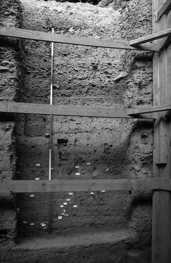
Trench D, viewed from the north at the end of the 2013 fieldwork; scale in 50 cm divisions (photo: G. Barker).

The stratigraphy of the north-facing and west-facing sections of Trench D at the end of the 2013 fieldwork; the numbers 52 and 53 shown within triangles in context 1054 refer to two potentially-humanly made lithics, classified as Small Finds 52 and 52 (drawing: R. Lane, J. Holman).

The 2013 excavations of Trench D revealed a further 1.45 m of laminated sediments (Fig. 7: contexts 1042–1072) formed by increasingly rapid deposition events together with periodic flood episodes. The stratigraphic units were dominated by clayey silt deposits with varying degrees of compactness and density of inclusions (Fig. 6). The units were on average 0.07 m thick and gradually increased in thickness to ~0.15 m thick towards the base of the sequence. All excavated material was extensively sampled for flotation to aid artefact and environmental data retrieval, and a sediment sample was taken from each stratigraphic unit (and at 5 cm intervals within larger units) to provide a continuous sequence for pollen analysis as a comparator for pollen from the column sample excavated in 2012 down the south-facing wall of the Deep Sounding.
The uppermost units (contexts 1043–1045 and 1054–1057) consisted of a 0.45 m-thick series of deposits below a small-scale rock-fall event that formed the base of the 2012 excavations. The deposits varied from red brown to pale cream brown and contained thin compacted lamina of mud flow and differing concentrations of small- to medium-size limestone fragments, a combination indicative of repeated fluvial and stagnation events as in the upper section of the trench. The deposits contained very rare evidence of human occupation including two potentially-humanly made lithics from context 1054 (Fig. 7: SF 52 and 53). Below the laminate event was a sequence of units (contexts 1058–1061) up to 0.36 m thick consisting of red-brown silt and silty clay that became increasingly orange with depth. Most of these deposits were uniform in colour and consistency apart from context 1059, a 0.05 m-thick lens of compacted red clay that contained a few small worked flints. There was a high degree of disturbance within the deposits from bioturbation that could have led to the upward dispersion of artefacts, but the lack of cultural materials such as shell and charcoal implies either a very low level of occupation of this part of the site or the abandonment or near-abandonment of the cave. Below these units was a 0.09 m-thick near-sterile red-brown silt (context 1062) containing abundant small- to medium-size limestone and degraded limestone fragments that may have derived from a small-scale roof collapse or shearing of calcite material during an extreme weather episode and which perhaps signal the complete abandonment of the cave at that time.
Below this event the earliest excavated phase was characterised by large amounts of shell inclusions and, less frequently, fragments of animal bone. The sequence consisted of six units (contexts 1063–1072) 0.47 m thick of layered red brown fine silts and pale yellowish-brown clayey silts. Each deposit was identifiable through differing concentrations of fragmented small to medium limestone fragments and varying levels of compaction. In addition a McBurney identification nail was located at the upper contact point of each major unit. Although shell was present throughout the sequence, an unusually high concentration of crushed shell was noted in the uppermost deposit (context 1063) that may be refuse from collection and processing by humans. Other evidence for human occupation included the constant presence of charcoal in the assemblage and occasional fragments of mammal bone, most of the latter being found in contexts 1067 and 1071. Though they have not been formally studied yet, they likely derive from medium-sized bovids and smaller ovicaprids, and two of the specimens had cut marks on their surfaces.
Bioturbation was prevalent throughout the sequence, with mole-rat burrows up to 0.08 m in diameter criss-crossing the excavated area horizontally and vertically (Fig. 8). It is not yet clear whether these are extremely old, like the sediments in which they occur, or were formed by mole-rats living in the trench during the 1950s excavations or during our own excavations (for example one was seen at the base of the Middle Trench during our own campaigns, before the Deep Sounding was emptied of backfill). Given the depth of the Trench D mole-rat burrows below the present-day ground surface, it is more likely that they were formed during the McBurney and present excavations rather than in antiquity. It is noticeable that mole-rat burrows are frequent in the soft silts but are absent from the compact sediments forming the lower part of Trench M. Wasp holes, also in evidence, are more likely to be contemporary with the archaeological deposits.
Burrows in the soft sediments of Trench D, assumed to be of mole-rats, viewed from the north: one crosses the trench diagonally on the left, and one is clearly visible vertically up the image to the right-hand end of the 1 m ranging pole (photo: G. Barker).

The ubiquity of charcoal in the Trench D sediments, albeit in very small quantities, together with the frequency of artefacts in the lower part of the excavated sequence compared with their rarity higher up, indicates a continued but declining human presence during the formation of the Deep Sounding sediments. It is noticeable that this apparent decline in human presence through time coincides with a decrease in the thickness of the silt units that may indicate a greater frequency of in-wash events.
Excavation ceased at the end of the 2013 season approximately 0.5 m above a large hearth structure that was associated with one of the main layers with Pre-Aurignacian material that McBurney found.
Conclusion
The 2013 excavations in the Haua Fteah marked a substantial extension in the depths of the trenches being cut down the side of the McBurney trench, though in the time and with the resources available we were unable to ‘connect’ Trenches M and D as we had hoped (Fig. 1). At the end of the field season the base of Trench M was about 0.5 m from the bottom of the Middle Trench (so also the top of the Deep Sounding and the top of Trench D) and the base of Trench D was about 1 m above the base of the Deep Sounding and 0.5 m above the main layer with Pre-Aurignacian material excavated by McBurney. We do not yet have OSL dates for the Deep Sounding (the sediment samples taken in 2012 are still being analysed) but the formation processes of the Facies 5 sediments exposed in Trench D, a mix of soil mass-movements caused by water flow and in situ sedimentation in standing water, are strongly indicative of an origin during the humid Marine Isotope Stage (MIS) 5 dated globally to c. 130–74 ka. Evidence for human occupation is sparse but present from the base of the trench (and indeed as stated above the main Pre-Aurignacian deposit lies just below its base) but appears to decline moving up the profile. This trend coincides with sedimentary evidence of more frequent disruptive climatic events, possibly associated with climatic instability during MIS 5. Carbonate precipitation in the basal layers of Trench M may relate to oscillating sub-humid and arid climate pulses within MIS 4, like the evidence of manganese precipitation above them indicative of repeated wetting and drying. Moving up the profile, silts of the kind that dominate the lower part of Trench M alternate with matrix and clast-supported weathered gravels, an interleaving of contrasting climatic conditions that probably marks the transition between MIS 3 and MIS 2. The 2014 excavation of the basal layers of Trench M also located a small patch of charcoal on top of one of the cemented carbonate units. This charcoal is the western edge of a large anthropogenic combustion feature visible to the east of Trench M in the north-facing wall of the Middle Trench (and described by McBurney). It is only about 10 cm above where the 1950s excavations found two mandibles of anatomically modern humans, though the overall paucity of Middle Stone Age material in this part of the sequence, as higher up in the layers excavated in 2012, is striking.
Acknowledgements
We acknowledge in particular the permission of the Department of Antiquities of Libya to undertake the project; the financial support of the European Research Council (Advanced Investigator Grant 230421: TRANS-NAP: Cultural Transformations and Environmental Transitions in North African Prehistory) and the Society for Libyan Studies for the fieldwork; and the invaluable logistical support provided by the staff of the Department of Antiquities in Tripoli, Shahat, and Susah. The 2013 team consisted of: Fadl Abdulazeez, Graeme Barker, Paul Bennett, Ahmed Buzaian, Lucy Farr, James Holman, Ross Lane, Abdullah Marasi, Amy Prendergast, Mohamed Twati and Mtaz al-Zweyi. The field season took place between 14 and 28 September 2013.