

INTRODUCTIONFootnote 1
This paper considers Roman pottery that was collected as part of an intensive survey of the Greek island of Antikythera, with particular focus on what this assemblage tells us about patterns of human activity on the island and over wider Aegean networks during the first to the seventh centuries ad. Antikythera is one of the smaller (20.8 km2) and more remote inhabited islands in the Mediterranean, but is situated along some key shipping lanes, between the Peloponnese and Crete and between the Adriatic and Aegean seas (see Fig. 1). It has had a long but very episodic history of human exploitation over some 7000 years, which has at times been punctuated by periods of near or total abandonment. Its pottery record is of great interest not only to specialists in the material culture of the region, but also to those interested in the challenging patterns of isolation and connection experienced by Mediterranean island communities, as well as the unusual material, ideological and subsistence strategies such challenges have sometimes promoted.
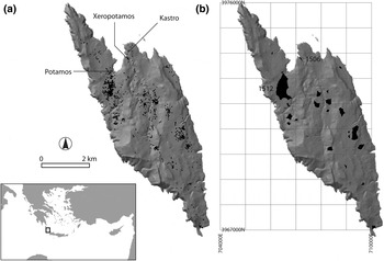
Maps of Antikythera showing (a) the island's general location in the Aegean and the distribution of Roman (mainly Late Roman) sherds recovered from systematic survey, and (b) the locations of denser artefact scatters along with the UTM grid (zone 34N, WGS84) used in the catalogue.

Perhaps the best-known archaeological discovery associated with Antikythera is a first-century bc shipwreck off the north coast of the island that produced the so-called Antikythera mechanism (an intricately geared astronomical device) and a range of other impressive bronze statues and ceramic and glass finds (most recently Freeth et al. Reference Freeth, Bitsakis, Moussas, Seiradakis, Tselikas, Mangou, Zafeiropoulou, Hadland, Cate, Ramsay, Allen, Cawley, Hockley, Malzbender, Gelb, Ambrisco and Edmunds2006, with further references). This shipwreck, as well as a range of finds at the impressively fortified site known as the Kastro on the island itself (Hellenistic material of late fourth to mid-first century bc date), reflects a period in which the documentary sources suggest that Antikythera, then referred to as Aegil(i)a, was heavily involved in piracy (Stais Reference Stais1889; Petrocheilos Reference Petrocheilos1987; Martis, Zoitopoulos and Tsaravopoulos Reference Martis, Zoitopoulos, Tsaravopoulos, Luca and Sîrbu2006; Tsaravopoulos Reference Tsaravopoulos2004–7; Johnston et al. forthcoming). In fact, the final destruction of this site is one plausibly linked to the anti-piracy of Creticus Metellus in 67–64 bc. Following this period, there may have been a break in settlement (that we discuss further below), but thereafter the island was clearly inhabited again by the Late Roman period, as recently documented by the excavation of several cist grave cemeteries (e.g. Pyrrou, Tsaravopoulos and Bojica Reference Pyrrou, Tsaravopoulos and Bojica2006).Footnote 2
In addition to these excavated finds, a complementary picture of human activity on Antikythera has recently been provided by a separate programme of intensive surface survey covering the whole island (the Antikythera Survey Project [ASP]). ASP has involved input from a broad range of specialists interested in the long-term human ecology of the island, in all periods of its history (e.g. Bevan, Conolly and Tsaravopoulos Reference Bevan, Conolly and Tsaravopoulos2008; Bevan and Conolly Reference Bevan and Conolly2009). The surface survey itself was one aspect of this research effort; its first stage (the only one of relevance here) was conducted in 2005–6 by five-person teams walking across the island in lines 15 m apart. ASP counted over 65,000 potsherds in this manner and made a permanent collection of about 7725 ‘feature’ sherds for subsequent laboratory study (i.e. all rims, bases, handles and all those with paint, glaze or other decoration). Of these collected finds from the first stage survey, nearly 4000 are most likely datable to somewhere within the first seven centuries ad, and this paper offers a detailed assessment and selected catalogue of them, to go alongside (i) a less discursive, but comprehensive online publication of ASP datasets in digital form and (ii) a short synthesis of the survey results to be published elsewhere.
The Roman pottery collected during the intensive survey of Antikythera offers a spatially controlled, landscape-scale view of the on- and off-island strategies pursued by its inhabitants and others who passed by, deliberately or by accident. However, as is often the case with survey material, the correct identification of different diagnostic shapes is sometimes hampered by the poor preservation of surface treatments such as slips and decoration. A total of 3886 sherds were collected that can definitively, or at least possibly, be dated to the Roman period (50.3% of the diagnostic sample), but of these only about 45% can be associated with well-known and attested ceramic types and hence be attributed to a sub-phase within this period (what we will hereafter call the ‘finely diagnostic’ material). Related to this problem is the fact that the vast majority of the Roman assemblage comprises body sherds (32%) and handles (43%, often heavily abraded), while rims and bases are fewer in number (18% and 7% respectively). This large proportion of only loosely identified and dated Roman material therefore necessitates caution in our interpretation of the overall assemblage, but two general patterns stand out very clearly:
• Some 80% of the finely diagnostic material can be dated to the Late Roman period (from late fourth/fifth to seventh century ad), while pottery unequivocally datable to the Early (in ASP terms, from first to second century ad) and Middle (from third to fourth century ad) Roman period is far less visible.
• Almost 60% of the artefacts analysed are transport amphorae (mainly fragments of bodies and handles, with the more finely diagnostic rims and toes far less well attested). Coarse wares are far less common (c.31%) and many of these are body sherds whose attribution to the Roman period remains uncertain. The amount of fine pottery is even more limited (c.5%).
As discussed further below, this survey assemblage requires careful interpretation. As David Pettegrew has stressed recently (2007), the quantities of Roman ceramics recovered by intensive surface surveys must be re-calibrated to compensate for the problems caused by differential diagnostic visibility. In particular, the frequently attested increase of Late Roman rural settlements and archaeological evidences in mainland and insular Greece in comparison with the fewer data relevant to the Early Roman period may partly reflect differences in visibility of the ceramic finds. In particular, a greater number of type fossils belonging to the Late Roman period (African Red Slip and Phocaean ware plates and bowls, grooved and ridged body sherds from amphorae) are significantly more visible and easily recognisable by surface treatment. By calibrating the ceramic data relevant to the East Corinthia survey, which were compared with others from different archaeological surveys in Greece, Pettegrew was able to demonstrate a more continuous pattern of habitation, trade and economic exploitation of the Greek landscape during the Roman period and more subtle increase of archaeological evidence in the Late Roman period than might otherwise be indicated in the raw data. A similar trend is also present to some degree on Antikythera, where grooved body sherds from amphorae comprise a significant proportion of the Late Roman evidence.
The discussion below is divided into two chronological sections and further categorised by consistent functional categories (e.g. fine tablewares, amphorae, coarse cooking wares, etc.). The accompanying catalogue of over a hundred drawn sherds provided here is only a small selection of the overall finds, but offers examples of the main forms on the island, as well as a point of departure for considering various off-island parallels. The catalogue uses a single running number sequence (1, 2, 3, etc.) throughout, but readers should also take note of the associated field identifiers (in brackets) as these are the ones physically marked on the finds and to be used in other ASP publications.
EARLY AND MIDDLE ROMAN POTTERY (FIRST TO EARLIER FOURTH CENTURY AD)
The Early and Middle Roman period represents approximately 18% of the overall Roman assemblage. On the whole, the presence of Italian and African imports as well as Aegean and Cretan amphorae in the Late Hellenistic Age/Early Roman period, and later, leads us to suggest a rather lively exchange which involved the island and is reminiscent of other well-known assemblages, such as those at Ephesus, where a recent analysis of the transport vessels suggests the occurrence of western supplies from the end of the second century bc (Bezeczky Reference Bezeczky, Malfitana, Poblome and Lund2006).
Fine wares (Fig. 2)
The amount of fine ware is very limited, consisting mainly of body sherds and bases, while rims are few. There is limited evidence for vessels of eastern production (9% of the overall pottery of this phase), of which the best attested is Eastern Sigillata C (ESC) that was probably produced at Pergamon from the second century bc until the late second or early third century ad (1). The other well-known eastern fabrics (e.g. ESA, ESB) are not securely attested within the survey assemblage, despite the fact that ESA plates and cups were found on the Antikythera shipwreck (Robinson Reference Robinson, Weinberg, Grace and Edwards1965, dated to the middle of the first century bc), but there are nonetheless some imitations of one form, ESB 60 (3), whose place of production is unknown. Other Early and Middle Roman fine wares such as Italian Sigillata and African Red Slip (fabrics A and A/D) have not been identified.
Line drawings of sherds 1 to 10.

Amphorae (Figs. 6–8)
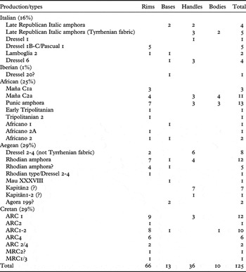
Table 1 offers a breakdown of Early and Middle Roman amphora types identified in the survey assemblage.
Attested types of Early and Middle Roman amphora.

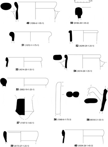
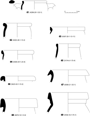
In contrast to the paucity of fine tablewares of Early to Middle Roman date, the evidence for transport amphorae is more substantial. Among this material, Aegean products seem to be better represented than Italian and African amphorae (the former comprising around 60% of the overall Early and Middle Roman amphorae assemblage). In particular, Cretan amphorae (58–63), typically associated with the transportation of local wine, are fairly common on Antikythera (29%), with ARC 1 and 2 well attested and ARC 4 less frequent (for the types, see Marangou-Lerat Reference Marangou-Lerat1995; Portale and Romeo Reference Portale and Romeo2000; Reference Portale and Romeo2001). Some sherds may also be from later Cretan amphora fabrics (64–65, types MRC 1/3 and MRC 2, see Portale and Romano Reference Portale and Romeo2000; also Hayes Reference Hayes1983, 141–3) and are thus possible, but uncertain, evidence that such amphorae may have been arriving on the island up until the Late Roman period. It is worth noting that Cretan amphorae were also found in significant quantities at Argos, from the first half of the first century bc (27–38% of all amphorae; Abadie-Reynal Reference Abadie-Reynal2007, 264).
As far as the other Aegean amphorae are concerned, the poor preservation of the sherds does not always allow firm identifications, especially for a series of rolled or rounded rims (which could be Rhodian, Knidian or Koan amphorae). Some fragments may be consistent with Late Rhodian wine amphorae, which developed from Hellenistic prototypes (51–54) and would date sometime within the period from the late first century bc to the mid-second century ad. Archaeometric analysis suggests several different production centres for these types, all probably located within the parts of the Aegean and western Anatolia that were under the economic and political control of Rhodes (such as the Rhodian Peraia and the Knidian peninsula; Empereur and Picon Reference Empereur and Picon1989; Empereur and Tuna Reference Empereur and Tuna1989; Whitbread Reference Whitbread1995, 53–67). Certain amphora rims among the survey material whose clay has distinctive red grains recall Rhodian fabric 1 (Peacock Reference Peacock1977; Peacock and Williams Reference Peacock and Williams1986, 103) and these suspicions of group V or VI Rhodian amphorae on the island are further strengthened by the presence of similar items in the cargo of the Antikythera shipwreck (Grace Reference Grace, Weinberg, Grace and Edwards1965, 14, fig. 2).
In addition, Dressel 2-4 amphorae are clearly attested on Antikythera by their distinctive bifid handles (e.g. 56): the fabrics of these might be Aegean but not Italian, as none have the black volcanic inclusions typical of Latial and Campanian Dressel 2-4 production. The few preserved rims of Dressel 2-4 may be consistent with a later type derived from the Koan amphora (55) that was very common in the Mediterranean area from the first century bc into the second century ad and exhibits a chronological evolution of the form (Grace Reference Grace1979). Koan-type amphorae have been also found in the cargo of the Antikythera shipwreck (Grace Reference Grace, Weinberg, Grace and Edwards1965, 15–16, figs. 1 and 4). A few handles may conceivably be of Kapitän II/Niederbieber 77 type (58; see Bruno Reference Bruno and Gandolfi2005, 288), but the attribution remains far from certain. The place of production for this wine amphora type is not known (perhaps Ephesus?), but from the end of the second to the fourth and fifth centuries ad it enjoyed a wide distribution across the Mediterranean from the Aegean to Gaul (for the Aegean, see Abadie-Reynal Reference Abadie-Reynal and Abadie-Reynal1989, 145; for Corinth, see also Slane Reference Slane2000, 301–2). Other amphorae of Aegean manufacture are very scarce: a ring foot may conceivably be from the Mau XXXVIII type (57), a wine amphora that was produced at Knidos and on or near the Datcha peninsula.
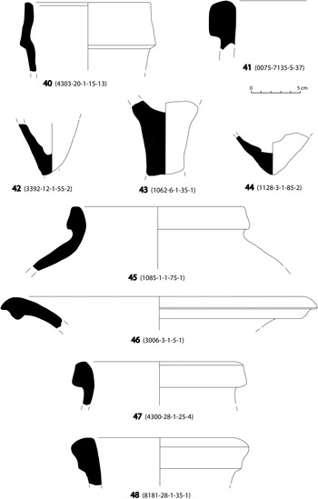
Late Republican and Early Roman Imperial (first century bc to first century ad) amphorae produced along the Italian Adriatic coast are attested by a few fragments of Lamboglia 2 and Dressel 6 (41–43), while some long oval-shaped handles and body sherds with a fabric rich in black volcanic inclusions are typical of the coastal area of Italy from Etruria to Campania. These are probably of the Dressel 1 type, one of the most common Late Republican Roman amphorae that circulated from the latter half of the second century bc to sometime during the first century bc. The identification of some high collar rims is problematic (40) since the shape is similar to a variant Dressel 1B, but the fabric does not seem to be Tyrrhenian and it is closer to that of a Pascual 1 amphora that was produced along the Catalan coast of northeastern Spain (from the middle of the first century bc to the end of the first century ad). Traditionally, the Lamboglia and Dressel 6 amphorae are thought to have been wine containers (Bruno Reference Bruno and Gandolfi2005), but the question of contents and provenance is more complex than first thought. Will (Reference Will, Hoff and Rotroff1997, 123–5) minimises the extent of Italic wine trade in the Aegean and assumes instead that these two amphora types mainly contained olive oil. On this interpretation, olive oil would have been the most popular comestible commodity imported in shipping amphorae to Athens and Delos during the late second and early first centuries bc. In contrast, but following the same logic, Aegean wines (mainly Rhodian and Knidian) would thus have been more popular than Italian wines, with the latter only starting to be imported to Athens in significant quantities from the latter half of the first century bc. Recently Lindhagen (Reference Lindhagen2009) has considered both Lamboglia and Dressel 6 to be wine amphorae arriving from the Dalmatian coast.
Overall the Late Hellenistic/Early Roman period imports from Italy to the island are limited in number but also occur on the Antikythera shipwreck (Grace Reference Grace, Weinberg, Grace and Edwards1965, 11). This limited presence of Italian wine amphorae is similar to the pattern observed at Gortyn on Crete, where analysis demonstrated that imports of Italian wine were very limited, while local products comprised over 80% of the amphora assemblage (Portale Reference Portale, Livadiotti and Simiakaki2004). However, when considered on the wider Aegean scale, these proportions are modest and run counter to the overall pattern of an increasing number of Italian wine amphorae in the Aegean after the fall of Corinth and Carthage (e.g. on Delos: Lund Reference Lund, Lund and Pentz2000, 86ff.). In contrast to these amphorae of probable Late Hellenistic/Early Roman date, no Middle Roman Italian amphorae have been identified on Antikythera.
Late Punic and Roman Imperial African amphorae are clearly present in the survey assemblage (25% of the Early and Middle Roman amphorae). In particular, amphorae from a Punic tradition (Maña C1a and C2a; 45–46) are clearly present. The production centres of these amphorae, whose content was probably fish sauce, were located in North Africa (Tunisia, Morocco, Tripolitania) and were certainly operating at the end of the third and the early part of the second century bc, but recently excavated contexts at Carthage also suggest that the date of Maña C2a/van der Werff 1 vessels can be extended into the first half of the first century ad (Martin-Kilcher Reference Martin-Kilcher1999). Early Tripolitanian amphorae which represent a typological link between Late Punic transport vessels and standardised Tripolitanian amphorae (mid-2nd century bc to the end of the 1st century bc or early 1st century ad) are also attested by at least one rim (47). Some commentators (Wolff Reference Wolff, Eiring and Lund2004; Lawall Reference Lawall, Malfitana, Poblome and Lund2006) have recently suggested that the modest numbers of Late Punic amphorae in the Aegean and eastern Mediterranean may have been the result of Roman economic protectionism that sought to circumscribe eastwards trade. However, they also note that there are possible recovery biases present here and the actual quantities of such amphorae may have been underestimated by comparison to Italian imports (due to a lesser degree of specialist awareness of possible Punic examples in this region). The African amphorae belonging to the Early and Middle Roman phases are far less common on Antikythera: a rim of Tripolitanian 2 type (48) and a few examples of Africana 2A (49–50) suggest the limited presence of these popular North African products on the island from the end of the first century ad to sometime in the fourth century ad (with the Tripolitanian vessels perhaps containing fish sauce and the Africana 2A possibly wine: Bonifay Reference Bonifay2004). The Antikythera data follow the general trend that suggests only a limited presence of African amphorae (which supplied Italian and western markets with oil and cereals) in the Aegean up to at least the fourth century ad, in contrast to African Red Slip vessels that were very popular in the eastern Mediterranean. This paucity of African amphorae can probably be explained as the result of local Aegean production of these foodstuffs during this period (Abadie-Reynal Reference Abadie-Reynal and Abadie-Reynal1989, 145–8).
Iberian imports are almost entirely absent from the Antikythera survey assemblage, apart from one possible base of a Dressel 20 type (44), despite the fact that these were the most common olive oil amphorae in the entire Mediterranean during the Roman Imperial period (from the first to the third century ad; for their occurrence in the Aegean, see Bernal Casasola Reference Bernal Casasola2000, 940–2).
Coarse wares (Fig. 12)
There are almost no securely identifiable coarse wares or cooking vessels from the island that date to the Early and Middle Roman phases. One exception however is a fragment from a casserole with an oblique rim and internal cavity for the lid (94) that might belong to a common type produced in the Aegean area during the Middle Roman period (Hayes Reference Hayes1983). It is notable that there are no clearly identifiable African cooking pots of this date in the Antikythera assemblage, except for perhaps one body sherd. Nevertheless, it remains possible that the very limited numbers of identified vessels of this functional type are partly an accident of recovery, given the large size of the Roman coarse ware assemblage that is morphologically undifferentiable by sub-phase.
LATE ROMAN POTTERY (LATER FOURTH TO SEVENTH CENTURY AD)
Late Roman pottery is present in far greater recorded quantities (1486 sherds) on the island than the pottery of the previous phases.
Fine wares (Figs. 3–5)
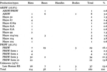
The fine tablewares summarised in Table 2 represent 11% of the overall pottery from this phase and perhaps more (25%) if we exclude body sherds from the calculation (see below). There is very clear evidence of the prevalence of Phocaean Red Slip ware (or Late Roman C), which exceeded half of the overall amount (58.2%); the African Red Slip is far less well attested (18.8%). Phocaean Red Slip ware (PRSW) was produced in Phocea and Gryneion from the end of the fourth to the mid-seventh century ad and contemporary local productions that imitated the Phocaean wares have been identified at several sites in Asia Minor, including Ephesus, Sardis, Pergamon, Chios, Priene and Anemurium (see Gassner Reference Gassner1997; Schneider Reference Schneider2000, 533, Ladstätter Reference Ladstätter and Krinzinger2005). A local imitation made on Crete has also been suggested, but without archaeometrical confirmation (Vogt, Gouin and Aloupi Reference Vogt, Gouin and Aloupi2000, 56–7; Vogt Reference Vogt, Livadiotti and Simiakaki2004, 925–8). PRSW was very common in the Aegean and the eastern Mediterranean from the end of the fifth century ad (Hayes Reference Hayes1972, 417–9 and 423–4) and it significantly outnumbers African Red Slip wares in most assemblages with only a few exceptions (e.g. Cyprus, around Alexandria, and in some parts of southern Asia Minor), reaching c.80–85% of the fine ware assemblages on Crete (e.g. Gortyn, Eleutherna) and at Argos (Abadie-Reynal Reference Abadie-Reynal2007, 150ff.; also dominant at Corinth: Slane Reference Slane2000, 303).
Line drawings of sherds 11 to 18.

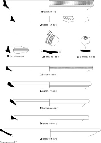
Line drawings of sherds 19 to 28.

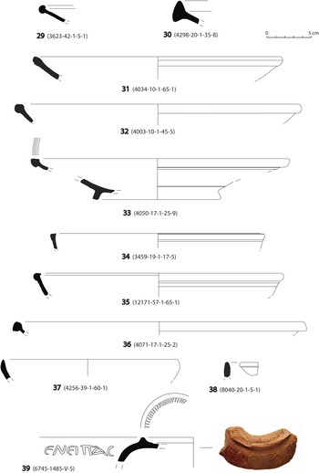
Line drawings of sherds 29 to 39.

Line drawings of sherds 40 to 48.

Line drawings of sherds 49 to 60.

Line drawings of sherds 61 to 69.

Attested types of Late Roman fine ware.

On the basis of new evidence and new publications, Hayes (Reference Hayes2008, 83–8) proposed recently a revision of some aspects of the PRSW, in particular regarding its early phases and the period after c.540–50 ad. Some Athenian contexts show the Phocaean ware in competition with the African products already by the early fifth century ad: in the late fifth century Agora groups the Phocaean ware topped 80–90% of the imported fine wares. Moreover, recent evidence from other sites such as San Giacomo degli Schiavoni (Italy), Iatrus (Bulgaria) and Beirut have to be considered for the redating of PRSW (Hayes Reference Hayes2008, 85–6: see also Slane and Sanders Reference Slane and Sanders2005, 283 and 289).
However, the PRSW vessels found on Antikythera comprise only a limited number of shapes and types. The frequency of earlier types (forms 1 and 2; 12–14, 16 and perhaps 15), which date throughout the end of the fourth and the first half of the fifth century ad, is fairly small and the main attested types are forms 3 and 10. The type 3 bowl (17–22) was the most widespread PRSW form in the Mediterranean area, especially between the second half of the fifth and the beginning of the second half of the sixth century ad, and includes numerous variants of fifth century (B and C) and sixth century (E) date, often with rouletting decoration (e.g. 23) and in one case a stamped ‘Star of David’ motif (27). Form 10 (24–26) dates from the late sixth century to the mid-seventh century ad and is supposed to be the last type produced in PRSW.
African Red Slip (ARS) wares were produced in northern Tunisia and are commonly attested in the Mediterranean during the Late Roman period. Their numbers are not as large in the Aegean and the eastern Mediterranean as they are in the western Mediterranean, not least due to the popularity of PRSW in the east. In this respect, however, the southwestern Aegean (from Crete to Boeotia) is an intermediate zone that was generally more receptive to African fine wares than the rest of the eastern Mediterranean (Sodini Reference Sodini2000, 194; Abadie-Reynal Reference Abadie-Reynal2007, 153–6). Starting from the third century ad, some ARS wares consistent with production C (such as types H45 and 50A) are massively attested in the south Aegean and exceed ESC production, for example at Argos (Abadie-Reynal Reference Abadie-Reynal and Abadie-Reynal1989, 144; 2007, 171), Athens (Hayes Reference Hayes2008, 71–3) and Corinth (Slane Reference Slane2000, 303 and 307: Slane Reference Slane, Williams and Bookidis2003, 330). This pattern is probably related to the foundation of Constantinople and the resulting increase of long-distance trade from west to east, in which centres such as Corinth played an important role as transhipment points (Slane Reference Slane, Williams and Bookidis2003, 331; see also Slane Reference Slane2000, 307 and 310–11). According to some commentators, the production of such fine wares ran alongside the increasing supplies of grain from North Africa to the East, which started even before the foundation of Constantinople (Abadie-Reynal Reference Abadie-Reynal2007, 173–4).
The number of African fine wares gradually decreases during the fifth century ad (Abadie-Reynal Reference Abadie-Reynal2007, 150ff.), at the same time as there is a sharp increase in PRSW, and they remain scarce in the Aegean until the second half of the sixth or early part of the seventh century ad, after which their quantities increase considerably at the same time as typical amounts of PRSW decrease slightly (Vogt Reference Vogt, Livadiotti and Simiakaki2004, 928–30). It might be assumed that strategically and economically important centres and exchange market points were mainly involved in this significant increase of African fine wares, such as Athens (Hayes Reference Hayes2008, 73), Corinth (Slane Reference Slane2000, 306), Antioch, Constantinople and Argos (Abadie-Reynal Reference Abadie-Reynal2007, 153–6). It is also noteworthy that the African Sigillata was associated with long-distance trade routes and the main urban centres, while the presence of Phocaean RS ware was also associated with secondary markets (Abadie-Reynal Reference Abadie-Reynal2007, 153–6).
In contrast to this general pattern, the prevalence of ARS wares on Antikythera seems slightly different. Just one rim belongs to the latest production of ARS fabric C (4) that can be dated to the fifth century ad. The rest of the ARS fragments on Antikythera belong to the later phases of ARS fabric D and are attested by a limited number of types (5–8) that, more broadly, are some of the most common ARS vessel shapes in the Mediterranean during the fifth and sixth centuries ad. On Antikythera, plates of Hayes form 67 (e.g. 6) that belong to the earlier phases of fabric D production (our variant is dated to the first half of the fifth century ad) are slightly more frequent than the other types. Plates of Hayes form 104 and 105 (9–10), that were circulating in the Mediterranean area from the second half of the sixth to the mid-seventh century ad, are the best represented and it is possible that further unattributed base fragments also belong to these type forms. In contrast, it is also interesting that the final products of ARS ware (i.e. the Hayes forms 108, 109, 99C) which were frequent throughout the seventh century ad seem to be missing from Antikythera.
Among the fine pottery there is also a significant number of red-slipped sherds (over 20% of the fine ware assemblage) that exhibit some consistency in shape, surface treatment and fabric, but that cannot at the moment be attributed to a known production group. They are dishes and bowls, characterised by a very fine fabric (pinkish or light brown in colour), with a very thin slip (sometimes quite diluted and uneven). Most of these vessels are similar to ARS Hayes forms 104 and 105, PRS Form 10 and Cypriot Red Slip ware forms 9 and 10 (28–29, 31–32, 34–35, 37) and hence match well the main ARS and PRS types found on the island. They also recall plates and bowls discovered in a seventh-century ad context at Knossos and interpreted as a ‘local/regional RS ware’ that was imitating ARS shapes (Hayes Reference Hayes2001, 445, figs. 6, 8–15). On the base of comparanda with ARS and PRS wares, this group may well be a discrete Late Roman production whose place of origin is still unknown.
These fine ware dishes and bowls make an interesting group and deserve to be studied more thoroughly and across a wider range of assemblages in order to identify one or more possible centres of production, to establish both their chronological range and their spatial distribution, and to clarify the full suite of forms that they imitate. In the Late Roman period, local imitations of ARS and PRS wares were very frequent in the Mediterranean basin and are evidence both for links between different production centres and for the impact of consumer preferences. Local RS fabrics have been identified, or at least suspected, for several sites on Crete, including Gortyn, Eleutherna and Knossos (Hayes Reference Hayes2001), at Argos on the mainland, and at many other sites in the Aegean and eastern Mediterranean, such as Demetrias, Ephesus and Sardis (Yangaki Reference Yangaki2005, 120, 291–2). The local production at Gortyn (‘ceramica ad engobbio rosso’) had a wide chronological range from the second to the sixth century ad and imitated prototypes consistent with ESB, ARS and PRS wares (with earlier production more heterogeneous, and Late Roman production more systematic and homogeneous: Dello Preite and Martin Reference Dello Preite and Martin1997; Lippolis Reference Lippolis2001). Vogt (Reference Vogt, Livadiotti and Simiakaki2004, 925–8) identified a production of pseudo-PRS ware at Eleutherna that he supposed to be local and that imitated exactly a series of Phocaean forms but over a longer chronological range (Yangaki Reference Yangaki2005, 291). These products were more common than ARS sherds at Eleutherna, but scarce in comparison with PRS wares. The description of local RS wares discovered at Argos (Aupert Reference Aupert1980, 418) suggests that they are very similar to the Antikytheran examples, with imitations of ARS Hayes forms 104 and 105, pink or generally pale fabrics and dull, non-uniform red slip.
At present it is very difficult to identify the place of origin of the RS wares found in Antikythera and to understand their economic and cultural impact. Moreover, the general overview of the local/regional fine wares is not yet well defined and does not permit a full knowledge of this issue, mainly as far as the links and the ratios to the most common imports are concerned. It might be supposed that the RS pottery from Antikythera could be consistent with a phenomenon which was common in the Mediterranean from the fifth to seventh centuries ad: a series of local fine ware industries which referred to common morphological patterns derived from the ARS and PRS formsFootnote 3 and supplied not only the production sites but also regional and interregional markets (Yangaki Reference Yangaki2005, 292–3). They were probably ateliers which carried out standardised production in a limited number of shapes and types imitating the imports attested in the sites where these workshops were identified; their productions were probably less expensive and supplied regional demands and purchasers who could not afford African and Phocaean imports and preferred local imitations and derivations (Yangaki Reference Yangaki2005). Fontana (Reference Fontana and Saguì1998, fig. 8) noticed that the sizes of the Italian imitations of ARS vessels were smaller than those of original wares and suggested that this was an intentional choice on the part of local ateliers to meet purchasers' requirements in integrating their vessels into small sets of shapes and different food practices.
Finally, an imported lamp is also attested among the fine wares (39). It is of a type that was very common throughout the fifth/sixth centuries ad in the Palestinian area, where it was produced, but which does not seem to have occurred very frequently in the Aegean. A Greek inscription in relief on the shoulder quotes a common religious formula (‘The light of Christ shines for all’) and some commentators (e.g. Leclercq Reference Leclercq, Cabrol and Leclercq1928, 1108–10) have suggested that these lamps played an important role in Palestinian Christian liturgy. In particular, it has been argued that they were part of a religious service associated with the ‘sacred fire’ that was the only ceremony authorised by the Greek church in the fifth/sixth centuries ad. The presence of these lamps outside Palestine is thus especially interesting and, as previously noted (Leclercq Reference Leclercq, Cabrol and Leclercq1928), may conceivably have been part of the personal possessions of pilgrims who had once taken part in the ceremony.
Amphorae (Figs. 9–10)
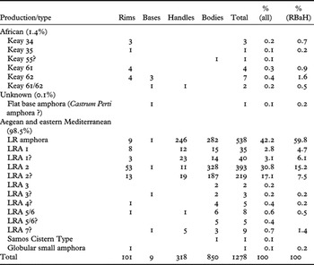
Transport amphorae are by far the best-attested ceramic class of the Late Roman assemblage. The distinctive groove decoration present on many of these vessels ensures that they are a highly recognisable class of artefact in field survey but consequently also risks biasing our assessment of other types and periods. All of the calculations below therefore seek to quote numerical ranges that both include and exclude body sherds in their calculations. In any event, transport amphorae comprise somewhere between 42 and 59% of the Late Roman assemblage (excluding or including body sherds). Those amphorae that can be more closely identified belong to a limited number of types and document the heavy dominance of Aegean and eastern vessels (and probably their contents) over African and Italian ones.
Line drawings of sherds 70 to 78.

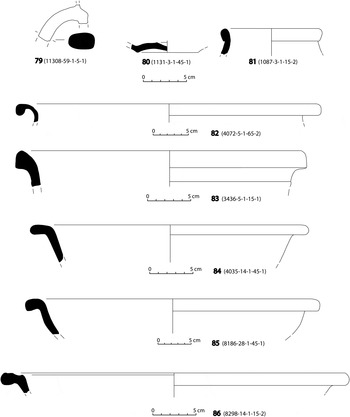
Line drawings of sherds 79 to 86.

As Table 3 should make clear, the best-represented type (74–75), attested by many distinctive grooved body sherds and a more limited number of rims, is the Late Roman Amphora 2 (22–48%, excluding or including body sherds). It is one of the most common amphorae in the Late Roman Aegean and eastern Mediterranean (Pieri Reference Pieri2005, 85–93; see also, for the Aegean occurrences, Karagiorgou Reference Karagiorgou, Kingsley and Decker2001, 139–45). The container has a capacity of c.40–45 litres and is globular with a short conical neck, an indistinct rim and two short handles from the shoulder to the neck, while the body is grooved with deep horizontal and later (late sixth century ad) wavy rilling. The type was produced from the early fourth century ad up to the first half of the seventh century ad, with a sequence of changes in overall form visible over the course of the period. Centres of production have been identified near or along the western Anatolian coast (probably on Chios and at Knidos) as well as in the Argolid (Kounoupi), but other places of origin are also possible. There is evidence that it was used to transport both wine and olive oil (as suggested by the Yassi Ada cargo for example: Karagiorgou Reference Karagiorgou, Kingsley and Decker2001, 146), but with greater overall evidence for wine as a typical content (Pieri Reference Pieri2005, 92–3).
Attested types of Late Roman amphora.

In contrast, Late Roman Amphora 1 (73) seems to be far less frequent than LRA 2 in the Antikythera assemblage (6% or 10%, excluding or including body sherds). This amphora (for which see Pieri Reference Pieri2005, 69–84) is characterised by a tall, narrow neck with a band rim and a small pear-shaped body. Its distinctive handles are wrapped to create a deep concave groove, or twisted, while the body has ridges that divide wide, stepped flat sections (the latter decoration occurring mainly in the sixth century ad). LRA 1 was produced along the southern coast of Turkey (Cilicia), and on Rhodes and Cyprus, during the fourth and the seventh centuries ad and had a large distribution throughout the Mediterranean, the Aegean, the Black Sea and even as far as the Atlantic. While some commentators have suggested that they sometimes contained olive oil, recent analysis by gas chromatography has reconfirmed that most probably carried wine (Williams Reference Williams, Briese and Vaag2005, 161). Only one rim (72) might tentatively be attributed to the latest variant of LRA 1 (sixth–seventh centuries ad), but it might alternatively be from a small, globular amphora, a type that frequently occurs in the Mediterranean from the seventh to ninth centuries ad.
The other eastern Late Roman amphorae of Riley's classification (LRA 3, 4, 5/6) are few in number and of uncertain identification. Some fragments might be attributed to the LRA 5/6, a bag-shaped amphora that was produced in Palestine and northern Egypt and occurred mainly in the eastern Mediterranean (Pieri Reference Pieri2005, 114–27). A rim (77) may be consistent with the latest derivations of LRA 5 of Ummayad date (seventh–eighth centuries ad). Few and dubious (e.g. 81) are the occurrences of another common Palestinan product, LRA 4 (Pieri Reference Pieri2005, 101–14), that had a wide distribution across the Mediterranean basin and may have contained the famous wines of Gaza (although recent analysis has demonstrated that these amphorae also carried olive and sesame oils: Pieri Reference Pieri2005, 111). Some further bases and handles (e.g. 78–79) in a hard dark-brown fabric typical of Nile clays may be from examples of LRA 7, a wine amphora produced in Egypt throughout the fourth and the seventh–eighth centuries ad. It is also worth noting that examples of western Anatolian production (LRA 3 and Samos Cistern Type) are very scarce in the survey assemblage.
The most widespread African Late Roman types in the Mediterranean are also present in the Antikythera survey material, though in limited numbers. They are characterised by a brick-red or orange clay that is rich in aeolian quartz, and by a white or cream external surface resulting from the use of saline water. The large cylindrical Keay 61 and 62 (68–70) produced in the regions of Byzacena and Zeugitana throughout the late fifth and the seventh century ad are the most common African amphorae on Antikythera. Keay 34 and 35 (66–67) are far less common, and Keay 55 is possibly represented by a single body sherd. The contents of these amphorae are uncertain; a recent study (Bonifay and Garnier Reference Bonifay, Garnier and Papi2007) re-examined the issue using chemical analysis and suggested that olive oil may not have been as dominant as traditionally thought (with garum or wine being plausible alternatives for type Keay 62).
Italian Late Roman amphorae do not seem to be clearly represented in the survey assemblage. The fabric of a flat base with a concave indentation (80) may be consistent with a Castrum Perti amphora, whose place of origin was North Africa or the Near East, but such a base characterised various types of fifth and sixth century amphorae in the central and eastern Mediterranean.
Coarse wares (Figs. 10–12)
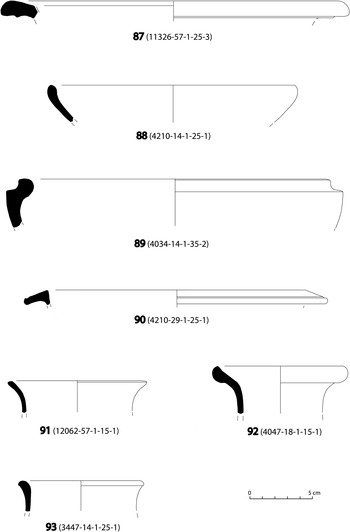
As noted above, coarse wares represent a surprisingly small proportion of the Roman assemblage from Antikythera (31–37%) and are only diagnostic of specific sub-phases in a limited number of cases. Despite this, at least some are certainly of Late Roman date, with cooking pots (95–99) and basins (82, 85–86) being the best-represented shapes, and bowls (88), jugs (93) and casseroles (100–101) present but less common. Among the cooking pots and the basins, the best-represented types have clear morphological similarities with those commonly attested in Late Roman Crete (especially at Knossos, Gortyn and Eleutherna), and for which a range of different fabrics have been identified. At present it is not possible to suggest a definite Cretan (or other) origin for the Antikytheran examples, but their fabric is very coarse and hard fired, light red in colour and rich in medium to large white inclusions (perhaps a combination of quartz, mica and calcite), while the basins are made in a finer and softer reddish yellow clay, with fewer, smaller inclusions and scarce mica.
Line drawings of sherds 87 to 93.

Line drawings of sherds 94 to 101.

DISCUSSION
The above discussion has focused on describing the functional categories, shapes and sub-types present in the Antikytheran survey assemblage. Two more general absences during the Hellenistic and Roman phases on the island that are also worth noting are the very limited number of roof-tiles (particularly clear in the Hellenistic) and near-complete lack of identifiable large storage jars (e.g. pithoi) other than amphorae. It is possible that organic materials were used for roofing instead and that the abundance of maritime transport containers was a suitable substitute for large-scale household storage. Turning briefly to spatial patterning, and as already noted above, the Early Roman period (in ASP terms, from the first to second century ad) is hard to explore as a clear distribution of material across the landscape because many of the diagnostics for this period have date ranges also extending back into the preceding Hellenistic and/or are found in the same general location as demonstrably Hellenistic sherds on the Kastro (late fourth century to mid-first century bc; see Johnston et al. forthcoming). Most of the material relevant to the first century bc consists of unstamped amphorae to which it is impossible to assign close historical dates. The Antikythera shipwreck does have material that is similar to that from the latest period of substantial occupation on the Kastro, but on the island itself material dating prior to the later first century bc is very sporadic beyond the highly nucleated zone around the Kastro, making it clear that the distribution of Roman, and especially Late Roman, activity represents an entirely different social and economic phenomenon. The few fragments of Late Republican amphorae (i.e. Late Rhodian and Koan types, Dressel 1, Lamboglia 2, Dressel 2-4, Dressel 6) come from different production areas in Italy and the Aegean, and their limited number does not allow us to identify any obvious similarities or differences with the pottery found in the neighbouring regions. However, it is worth noting that the limited presence of Italian wine amphorae on Antikythera may reflect a localised phenomenon observed in immediately neighbouring areas such as Crete (e.g. at Gortyn), while at the same time running counter to the overall pattern of increasing amounts of Italian wine amphorae in the wider Aegean after the fall of Corinth and Carthage (e.g. on Delos). In contrast, the paucity of Late Punic and Roman Imperial African amphorae on Antikythera conforms with a more general trend that suggests a limited presence of African amphorae in the Aegean up to at least the fourth century ad.
For the Early and Middle Roman phases (in ASP terms, from the third to fourth century ad), our interpretation is constrained by the fact that some of the material that might be of this date also spans longer time ranges, and hence is not wholly diagnostic. Even so, there is certainly a small amount of material that is undeniably Early and Middle Roman and this clusters around the Xeropotamos and Potamos harbours, probably suggesting that limited visitation by passing ships and occasional habitation were the prevailing patterns of island exploitation rather than widespread occupation. We stress below, however, that such a conclusion is biased by the very skewed nature of our chronological indicators and should be treated with caution. Nevertheless, the pottery of this date from Antikythera includes some of the main shapes and amphora types attested in the central Aegean and seems to emphasise close relations with Crete, whose trade containers are particularly well attested.
For the Late Roman period (in ASP terms, from the late fourth or the start of the fifth century to the seventh century ad), we can document a range of denser clusters of surface material (Fig. 1), often accompanied by small groups of contemporary cist graves, each at the heart of a more fertile region of the island. Most of these appear to be relatively small hamlets (and/or looser spatial groupings of farmsteads) of perhaps several families at most, but one above the modern town of Potamos (Fig. 1b: location 1512) suggests a much larger village. Some Late Roman evidence from the Xeropotamos harbour suggests its continued importance during this period (e.g. Fig. 1b: location 1506), but the Potamos harbour may have been increasingly dominant, especially given the suspicion that a combination of tectonic uplift and alluvial build-up would have made the former increasingly difficult to use. A preliminary assessment of the assemblages from individual Late Roman scatters around the island does not offer clear evidence for functional, chronological or ware-specific differentiation, suggesting that most communities on the island had access to comparable kinds of ceramics over most of the Late Roman period, and were probably using them for similar purposes. Other finds from the Late Roman scatters include glass vessels and some probable groundstone tools (though the latter were not chronologically diagnostic and were only attributed to this period circumstantially because of their findspots).
The pottery evidence, at first glance, therefore suggests an episode of recolonisation and far more substantial activity during the Late Roman period. This pattern is partly the result of the higher visibility of Late Roman body sherds, with the perceived rate of change in quantities of sherds being very dependent on what kind of evidence we include (e.g. the ‘factor increase’ shown in Table 4, following the method suggested in Pettegrew Reference Pettegrew2007, 771–5), but in all cases it demonstrates much activity in Late Roman times and there is a real risk that we also overestimate earlier periods due to overlap with the period of occupation of the Hellenistic Kastro as noted above. In contrast, the end of this period of activity on the island is fairly clear-cut, with very little or no identifiable material after some time in the seventh century ad until the twelfth century ad (Vroom, Bevan and Conolly in prep.), suggesting almost complete abandonment for a period of 400–500 years.
Comparison of factor increases between the Early/Middle and Late Roman periods for (i) all sherds (ii) rims, bases and handles (RBaH) and (iii) rims and bases only (RBa).

The Late Roman pottery assemblage also suggests economic and cultural links primarily with the Aegean (perhaps the Argolid in particular) and the eastern Mediterranean (mainly western Anatolia), as emphasised by the great quantity of LR1–2 amphorae and Phocaean RS wares, while Palestinian and Egyptian products are rare except for a few LR 5/6 and 7 amphorae. The paucity of Palestinian amphorae contrasts with the general pattern in the wider Aegean where these vessels are widely documented at numerous sites such as Argos (from the fourth century ad: Abadie-Reynal Reference Abadie-Reynal2007, 271) and Corinth (mainly LRA 5/6 and 4 types: Slane Reference Slane2000, 304–5). The direct relationship with Crete appears far stronger in Late Hellenistic or Earlier Roman phases than in later ones; more precisely, Late Roman Cretan amphorae are possibly present in very small numbers but very rare on the island (though it is worth noting more generally that these were in the main not exported types; Portale Reference Portale, Livadiotti and Simiakaki2004). The low frequency of the large cylindrical amphorae during the late fifth to the first half of the seventh century ad also suggests that the island was only a minor participant in a system of exchanges that can otherwise be documented linking the western Mediterranean with eastern Mediterranean centres such as Constantinople in the Late Roman period (see Bonifay Reference Bonifay2004, 480ff.). However, as Bonifay notes (2004, 446), the lower numbers of African amphorae in the fifth century ad compared to the large numbers of contemporary Aegean and eastern Mediterranean containers may not actually indicate a decline in the amounts of traded African products circulating (i.e. in the amounts of product contained within the amphorae) because the former had a far larger capacity than the latter. In other words, the raw frequencies of pottery containers from these different regions need to be carefully calibrated with regard to their varying capacities and due attention paid to whether they arrived at their point of archaeological deposition still containing their original contents or via secondary channels of reuse (see below). Moreover, it is worth emphasising that the distribution pattern of the African amphorae is different from that of the ARS wares (with the former being far less frequently attested than the latter in the Aegean), suggesting that African amphorae and fine wares probably followed different trade routes and catered for different markets (Abadie-Reynal Reference Abadie-Reynal2007, 158–9). In the case of Antikythera, the chronological range of ARSW exhibits a slightly different pattern from neighbouring areas: ARSW fabric C, which is otherwise very popular in the southern Aegean and on mainland Greece (i.e. Crete, Argos, Corinth, Athens), exceeding the amount of eastern fine wares at some sites, is scarcely attested on our island, where ARSW is only really documented for the fifth century ad. Furthermore, the latest types of ARSW are not found on Antikythera, despite being otherwise frequent throughout the Aegean in the seventh century ad. In contrast, the predominance of the Phocaean fine wares in the Antikythera assemblage during the fifth to the seventh century ad is entirely consistent with a more general trend in the Aegean and the eastern Mediterranean, in terms of the popularity of local and regional industries which produced red-slipped fine wares whose forms were often derived from the ARSW and PRSW.
The Late Roman finds from Antikythera can also perhaps be fitted into a wider emphasis on Aegean coastal sites in important maritime positions during this phase (Pettegrew Reference Pettegrew2007, 774). Moreover, the closeness of Crete probably had important effects in the economy and in the distribution of commodities in the small island. In fact it was noticed how there was in Gortyn an increase of amphora imports (mainly LRA 2) and a decrease in local productions through the fourth and the eighth centuries ad (Portale and Romeo Reference Portale and Romeo2001). The presence of African amphorae has led to the supposition that Crete played an important role along the east–west long-distance route in order to redistribute the African products in the Aegean and, perhaps, in the southeastern Mediterranean after the end of Vandal rule and the Byzantine recovery of the western empire (i.e. the second half of the sixth century ad). As discussed above, this long-distance trade route emerged rapidly with the rise of Constantinople in the fourth century ad, in relation to the state-dominated supply of the eastern regions of the Empire with North African grain (i.e. the annona). From the fifth century ad, exports of goods from the east to Italy and North Africa also increased, as the conspicuous evidence of Palestinian and western Anatolian amphorae, as well as Phocaean fine wares, suggests (Abadie-Reynal Reference Abadie-Reynal2007, 173–4). This phenomenon seems to have mainly affected the southern Aegean, especially Crete where African Sigillata are attested in large numbers at various sites during the sixth century ad (Sparta, Athens, Kenchreai). In the second half of the sixth to the seventh century ad, only the main economic and political centres in the east (e.g. Antioch, Constantinople) exhibit a significant interest in African commodities (Abadie-Reynal Reference Abadie-Reynal2007, 153–7) and there is evidence for increasing regionalism in exchange patterns (Slane and Sanders Reference Slane and Sanders2005, 290).
It is possible that specific historical events are behind these phenomena, and it is not inconceivable that the imported commodities documented by the Antikytheran material reflect the direct intervention of the Byzantine central administration and even the establishment of a strategic outpost on the island (see Pettegrew Reference Pettegrew2007, 778). This hypothesis is also prompted by suspicions we have from our field reconnaissance that some of the walls on the plateau south of the modern village of Potamos (centred on 706420E, 3972720N in UTM WGS84 zone 30N) may originally represent efforts at Late Roman fortification (or at the very least more substantial, non-domestic construction), though no clear-cut proof is forthcoming. In contrast, an alternative explanation is proposed by Lund (Reference Lund, Bonifay and Tréglia2007), who has suggested that the amphorae from a survey of the Akamas peninsula in western Cyprus, rather than reflecting primary consumption of the amphora contents, may have been recycled as milk or water containers for the needs of local farmers and shepherds. This explanation is particularly possible for Late Roman 1 amphorae that have a low capacity, but the secondary storage hypothesis may conceivably also be relevant for larger capacity vessels that might have stood in for pithoi in some households (the latter being a shape that we have not been able to identify with any confidence for the Late Roman period on the island).
Many of these remaining uncertainties outline possible opportunities for further study, but what this paper still provides is one of the first systematic studies of a spatially ‘comprehensive’ assemblage from a Mediterranean island. Antikythera's comparatively remote location and seemingly discontinuous history of permanent occupation implies a contingent and variable engagement with the wider geopolitics of the Roman world and therefore offers a useful point of analytical comparison and contrast to Roman assemblages recovered from more mainstream locations.
CATALOGUE OF ILLUSTRATED SHERDS
The sherds in this catalogue are numbered in bold with a sequence unique to this publication. Field numbers in most cases are indicated in brackets (e.g. ‘8130-28-1-65-8’), providing a unique identifier of the stage one survey unit, surveyor, distance walked and sherd number within the unit (technically ‘tract-walker-pass-distance-sherd’). In one case (41), the catalogued sherd comes from finer-scale, stage two collection (applied to mainly prehistoric scatters). In this case, the field number takes the form of ‘0075-7135-S-37’, which is a unique identifier comprising a grid square ID (0075-7135), an indication of the collection stage (S) and sherd number (37). These field numbers are the ones physically marked on the finds or finds bags and are also used in other ASP publications. A location for each potsherd is provided in metres (UTM zone 34N, WGS84, see Fig. 1), with a working accuracy typically within 10 m. All other measurements are in centimetres.
Fine wares
1 (8130-28-1-65-8) 706599E, 3973079N
Cup, rim. ESC ware. Curved and indistinct on the top portion of the rim and hemispherical body: ESC form H 4 or type Meyer-Schlichtmann NA 12. D. 22 cm, H. 2.7 cm. Fine and soft reddish yellow (5YR 6/8) fabric with few small white inclusions; sharp and smooth fracture. Traces of red slip (10R 5/6) are badly preserved on the interior surface(?). References: Atlante II, 78, pl. XVIII.4 (end of 2nd–3rd century ad); Meyer-Schlichtmann Reference Meyer-Schlichtmann1988, 98 pl. 11. See also a Sagalassos Red Slip cup, of which several variants appear in the second half of the 1st century to the 3rd century ad: Poblome Reference Poblome1999, 304, type 1A100, fig. 5. Date: End of the 2nd to the 3rd century ad (Meyer-Schlichtmann dates the type from the end of the 1st century bc to 50 ad).
2 (4268-18-1-5-1) 707067E, 3972005N
Plate, rim, unidentified ware and type. D. 34 cm, H. 7 cm. Fine and friable red (5YR 6/6) fabric, with a few small white inclusions; sharp and smooth fracture of the section. Interior and exterior red slip, badly preserved (10R 5/6). References: The fragment recalls ESA form 6, which was attested from the late 2nd century bc to the late 1st century bc: Atlante II, 17, pl. II, no. 3–4. See also Kenrick Reference Kenrick1985, 227, n. 316.2, fig. 41 (Augustan Age). A similar form was present in Sagalassos Red Slip ware from the second half of the 1st century ad to the 3rd century ad: Poblome Reference Poblome1999, 308, variant 1C132, fig. 57.4. Date: 1st to 3rd century ad.
3 (3177-6-1-95-1) 705350E, 3974509N
Bowl, thick vertical rim and truncated-conical body. Imitation of ESB form 60. D. not measurable, H. 4 cm. Fairly fine and hard reddish yellow (7.5YR 6/4) fabric, occasional inclusions of small and medium size. Exterior red (10YR 5/6) and interior black slip. References: The ESB form is dated between 50 bc and the early 3rd century ad (Hayes Reference Hayes2008, 39, no. 345–74, from the Athenian Agora). See also Slane Reference Slane1990, 49–50, no. 94, fig. 6 (Corinth, first half of the 2nd century ad). An imitation in local buff ware is attested from the excavations of the Villa Dionysos at Knossos: Hayes Reference Hayes1983, 122, fig. 10, no. 122 (2nd–3rd century ad?). Local imitations and variants of this type are also present in Athenian assemblages from the late 1st to the second half of the 3rd century ad: Robinson Reference Robinson1959, 40–1, 54, 61, 74, G 173–G 174, J 32, K 13, L 1, pls. 67–8 and 70. Date: 2nd to 3rd century ad.
4 (3394-12-1-15-1) 707876E, 3972374N
Bowl, rim. ARS ware (production C), type Hayes 82A. D. 32 cm, H. 4 cm. Fine and hard orange (2.5YR 6/8) fabric, sporadic small white inclusions; sharp and smooth fracture of the section. Exterior and interior dull red slip, which is very similar to the colour of the clay. References: Hayes Reference Hayes1972, 129, fig. 23, 2; Atlante I, pl. XXIX. 9–11 (430–500 ad). It is the most attested type of the production C in Argos: Abadie-Reynal Reference Abadie-Reynal2007, 160–1, nos. 264–6, pl. 38. Date: 430–475 ad.
5 (3678-34-1-5-4) 708296E, 3970282N
Bowl, rim. ARS ware (production D), type Hayes 50. D. 38 cm, H. 3.3 cm. Very fine and hard orange (2.5YR 6/8) fabric, occasional small white inclusions (quartz?); sharp and smooth fracture of the section. Exterior and interior dull red slip; its colour is the same as that of the clay. References: Atlante I, 86, pl. XXXVII. 1. Date: 350–400 ad.
6 (5127-2-1-5-1) 708764E, 3973459N
Plate, rim; ARS ware (production D), type Hayes 67. No. 1, 4, 9. D. 36 cm, H. 1 cm. Very fine and hard orange (2.5YR 6/8) fabric, scarce small white inclusions (quartz?); sharp and smooth fracture of the section. Exterior and interior dull slip, badly preserved; its colour is the same as that of the clay. References: Atlante I, pl. XXXVII. 9. The type is attested in an assemblage dating to the first quarter of the 5th century ad at Argos: Ivantchik Reference Ivantchik2002, 378, no. 107, fig. 14. Date: 360–470 ad. Bonifay (Reference Bonifay2004, 171–2, fig. 92, 6) identified this type as a variant which was very common mainly in the first half of the 5th century ad.
7 (12294-58-1-15-1) 709958E, 3969685N
Bowl, rim. ARS ware (production D), variant of the Hayes type 87A? D. 38 cm, H. 2.5 cm. Very fine and hard orange (2.5YR 6/8) fabric, scarce small white inclusions (quartz?); sharp and smooth fracture of the section. Thick and dull slip on the surfaces; its colour is that of the clay. References: Atlante I, pl. XLI, 5–7; Bonifay Reference Bonifay2004, 173–5. Date: Second half of the 5th century ad.
8 (7135-25-1-45-1) 708257E, 3972080N
Bowl, rim. ARS ware (production D), type Hayes 99 A-B. D. 20 cm, H. 3.2 cm. Very fine and hard orange (2.5YR 6/8) fabric, scarce small and white inclusions (quartz?); sharp and smooth fracture of the section. Outer and inner dull slip, badly preserved; its colour is that of the clay. References: Atlante I, pl. L, no. 11–15, pl. LI, no. 1–6; Bonifay Reference Bonifay2004, 181. Date: 510–80 ad. The most recent variant of this type dates back to the end of the 6th/early 7th century ad. Hayes Reference Hayes2008, 232, no. 1155, fig. 36.
9 (4074-5-1-5-1) 706416E, 3972253N
Plate, rim. ARS ware, type Hayes 104 (?). D. 38 cm, H. 1.7 cm. Quite fine and hard orange (2.5YR 6/8) fabric, occasional small, white inclusions (quartz?); sharp and smooth fracture of the section. Occasional traces of slip. References: Atlante I, 96, pl XLIV, 3; Bonifay Reference Bonifay2004, 181–3 (variant B) fig. 97. 34, Date: This type is attested from 550 to 650 ad. This fragment may be attributed to the late variant of the 7th century (Hayes type 104.22).
10 (3680-42-1-45-1) 708291E, 3970184N
Plate, rim. ARS ware (?), type Hayes 105. D. 34 cm, H. 2 cm. Quite fine and soft fabric (2.5YR 5/6), few small inclusions (quartz, mica?); sharp and rough fracture of the section. The slip is almost completely lost. References: Hayes Reference Hayes1972, 167, fig. 31, n. 17; Atlante I, 96, pl. XLIV, 1–2. Date: End of the 6th century to 650 ad.
11 (8115-36-1-55-1) 709286E, 3970745N
Plate, base with a vertical and high foot, unidentified ware and type (ARS?). Multiple rouletting decoration on the inner surface and unidentified motif in the centre. D. 19 cm, H. 2.7 cm. Very fine and hard-fired fabric (2.5Y 7/1), occasional small white and grey inclusions (quartz?); sharp and smooth fracture of the section. Thick light-brown slip on both of the surfaces. References: the high and vertical foot recalls those of some ARS types (Hayes 104 and 105); while the multiple rouletting decoration is consistent with motifs frequently attested on some forms of Late Roman Phocaean ware: see Gandolfi Reference Gandolfi and Gandolfi2005. Date: 5th–6th centuries ad.
12 (3680-42-1-45-2) 708290E, 3970182N
Bowl, rim. PRS ware, form 1A. D. 18 cm, H. 2.7 cm. Very fine and hard orange (2.5YR 6/8) fabric, occasional small white and yellow inclusions; sharp and smooth fracture of the section. Dull red slip (2.5YR 5/8), badly preserved on both surfaces. References: Martin Reference Martin and Saguì1998, fig. 1, Form 1A, no. 1–2; Gandolfi Reference Gandolfi and Gandolfi2005, 234, pl. 1, form 1A. Ladstätter Reference Ladstätter and Krinzinger2005, 168, pl. 1, 6 (from Ephesus, late 4th century ad). Date: Late 4th to the beginning of the 5th century ad.
13 (7129-40-1-25-1) 708384E, 3972050N
Bowl, rim. PRS ware, form 1B. D. 26 cm, H. 2.2 cm. Very fine and hard orange (2.5YR 6/8) fabric, occasional small white and yellow inclusions; sharp and smooth fracture of the section. Dull red slip (2.5YR 5/8), badly preserved on both of the surfaces. References: Martin Reference Martin and Saguì1998, fig. 1, Form 1B, no. 3; Gandolfi Reference Gandolfi and Gandolfi2005, 234, pl. 1, form 1B; Ladstätter Reference Ladstätter and Krinzinger2005, 168, pl. 1, 4 (from Ephesus). Date: End of the 4th to the third quarter of the 5th century ad.
14 (4222-29-1-35-1) 706813E, 3972244N
Bowl, rim. PRS ware, form 1D. D. 34 cm, H. 1.8 cm. Very fine and hard orange (2.5YR 6/8) fabric, small white and yellow inclusions in small quantities; sharp and smooth fracture of the section. Dull red slip (2.5YR 5/8), badly preserved on both of the surfaces. References: Martin Reference Martin and Saguì1998, fig. 1, Form 1, no. 7; Gandolfi Reference Gandolfi and Gandolfi2005, 234, pl. 1, form 1D; Ladstätter Reference Ladstätter and Krinzinger2005, p. 168, pl. 1, 7 (from Ephesus, late 4th century ad). Date: Early to third quarter of 5th century ad.
15 (17005-103-1-35-4) 707892E, 3972407N
Bowl-plate, rim, unidentified ware (PRS?). Multiple rouletting decoration on the inner profile of rim. D 34 cm, H. 1.5 cm. Very fine and hard-fired grey (10YR 6/3) fabric; sharp and smooth fracture of the section. Dull reddish yellow slip (7.5YR 6/6), poorly preserved. References: The rim shape is very similar to that of PRS Form 2 (Martin Reference Martin and Saguì1998, fig. 1; Gandolfi Reference Gandolfi and Gandolfi2005, 234–5, pl. 1, form 2A); but the decoration, while quite common on some ARS and PRS types, is not otherwise attested for PRS Form 2. Date: 370–450 ad.
16 (4076-14-1-15-3) 706348E, 3972451N
Bowl-plate, rim. PRS ware, form 2A. D. 30 cm, H. 1.6 cm. Very fine and hard red (2.5YR 6/6) fabric, small white and yellow inclusions in sparse quantities; sharp and smooth fracture of the section. Dull and quite thick orange slip (2.5YR 5/8). References: Martin Reference Martin and Saguì1998, fig. 1, Form 2, no. 1; Gandolfi Reference Gandolfi and Gandolfi2005, 234–5, pl. 1, form 2A; Ladstätter Reference Ladstätter and Krinzinger2005, 169, pl. 1, 16 (from Ephesus, late 4th to the first half of the 5th century ad). Date: 370–450 ad.
17 (8019-36-1-55-2) 709106E, 3971243N
Bowl, rim. PRS ware, form 3C. D. 22 cm, H. 1–7 cm. Very fine and hard orange (7.5YR 5/4) fabric, small white and yellow inclusions in sparse quantities; sharp and smooth fracture of the section. Thin and not uniform orange slip (2.5YR 6/6). References: Martin Reference Martin and Saguì1998, fig. 2, Form 3C, no. 7; Gandolfi Reference Gandolfi and Gandolfi2005, 235, pl. 1, form 3C; Ladstätter Reference Ladstätter and Krinzinger2005, 170, pl. 3, 32 (from Ephesus, 5th century ad). Date: 450–480/90 ad. Recently Hayes (Reference Hayes2008, 87–8) has dated form 3 from the early 5th to the third quarter of the 6th century ad.
18 (8231-26-1-5-1) 708651E, 3971954N
Bowl, rim. PRS ware, form 3B. Multiple rouletting decoration on the outer face of the rim. D. 32 cm, H. 3 cm. Very fine and soft fabric (10YR 8/4), occasional small white and yellow inclusions; sharp and smooth fracture of the section. The slip is not preserved. References: Hayes Reference Hayes1972, 331, fig. 67, no. 5. For the decoration see also: Gandolfi Reference Gandolfi and Gandolfi2005, pl. 6A (from Cerro de Montroy); Ladstätter Reference Ladstätter and Krinzinger2005, 172, pl. 4, 46 (from Ephesus, 6th century ad). Date: 450–480/90 ad. See no. 17.
19 (6003-2-1-5-1) 708267E, 3971727N
Bowl, rim. PRS ware, form 3B-C. One line of rouletting decoration on the outer surface of rim. D. 33 cm, H. 3.5 cm. Very fine and hard fabric (2.5YR 6/6), occasional small white and yellow inclusions; sharp and smooth fracture of the section. Orange slip (2.5YR 6/8), thick on the inner surface and thin on the outer one. References: Hayes Reference Hayes1972, 331, fig. 67, no. 5. For the decoration: Hayes Reference Hayes1972, 333, fig. 68, no. 14; Ladstätter Reference Ladstätter and Krinzinger2005, 172, pl. 4, 50 (Ephesus, 5th century ad); Hayes Reference Hayes2008, 240, no. 1266, fig. 39 (Athens, third quarter of the 5th century ad). Date: See no. 18.
20 (3393-16-1-85-1) 707834E, 3972323N
Bowl, rim. PRS ware, form 3 (E?). One line of rouletting decoration on the outer face of rim. D. 29 cm, H. 2.5 cm. Very fine and hard fabric (2.5 YR 6-8), sparse quantities of small white and yellow inclusions; sharp and smooth fracture of the section. Thin and badly preserved orange slip (2.5 YR 6-8). References: Martin Reference Martin and Saguì1998, fig. 3, Form 3E, no. 15; Gandolfi Reference Gandolfi and Gandolfi2005, 235, pl. 2, form 3E. For the decoration: Ladstätter Reference Ladstätter and Krinzinger2005, 171, pl. 3, 34 (Ephesus, 5th century ad); Hayes Reference Hayes2008, 243, no. 1296, fig. 40 (Athens, late 5th century to 500 ad); Rizzo Reference Rizzo2001, 59, pl. X, f (Gortyn, late 5th century ad). Date: Second half of the 5th to the beginning of the 6th century ad.
21 (8113-20-1-45-1) 709339E, 3970878N
Bowl, rim. PRS ware, form 3 (E?). D. not measurable, H. 2.5 cm. Very fine and hard-fired fabric (10 YR 5-1), sparse quantities of small white and yellow inclusions; sharp and smooth fracture of the section. Reddish brown slip partially preserved on the outer surface. References: Martin Reference Martin and Saguì1998, fig. 3, Form 3E, no. 15; Gandolfi Reference Gandolfi and Gandolfi2005, 235, pl. 2, form 3E; Ladstätter Reference Ladstätter and Krinzinger2005, 173, pl. 5, 64 (Ephesus, variant of small size, 5th century ad). Date: Second half of the 5th to the beginning of the 6th century ad.
22 (7138-5-1-55-2) 708359E, 3972162N
Bowl, rim. PRS ware, form 3. Two close-set lines of deeply impressed rouletting decoration on the outside. D. 32 cm, H. 2 cm. Very fine and soft fabric (2.5YR 6/8), sparse quantities of small white and yellow inclusions; sharp and smooth fracture of the section. Few traces of the slip are present on the surface. References: Martin Reference Martin and Saguì1998, fig. 3, Form 3F, no. 23 (mainly for the decoration). For shape and decoration: Ladstätter Reference Ladstätter and Krinzinger2005, 172–3, pl. 5, 54–6 (Ephesus, 5th century ad); Hayes Reference Hayes2008, 241, no. 1280, fig. 39 (Athens, from a context of second quarter of 6th century ad); Rizzo Reference Rizzo2001, 59, pl. XI, e (from Gortyn, late 5th century ad); Dello Preite Reference Dello Preite1997, 174, n. 68, pl. XXV, 4 (from Gortyn). Date: Late 5th to the second quarter of the 6th century ad.
23 (6007-16-1-65-1) 708282E, 3971682N
Bowl, base. PRS ware, probably related to shape 3. Two bands of rouletting decorate the inner surface. D. not measurable, H. 1.6 cm. Very fine and soft fabric (2.5YR 6/6), sparse quantities of small white and yellow inclusions; sharp and smooth fracture of the section. A rather poorly preserved red slip (2.5 YR 6-8) is present on the surface. References: Martin Reference Martin and Saguì1998, fig. 3, Form 3, no. 2, 4 e 5. For the decoration Gandolfi Reference Gandolfi and Gandolfi2005, 235, pl. 6, A (Cerro de Montroy, second half of the 6th century ad). Date: Second half of the 5th century to 550 ad.
24 (4020-17-1-15-5) 706682E, 3972759N
Bowl, rim. PRS ware, form 10A. D. 30 cm, H. 2 cm. Very fine and soft fabric (2.5YR 6/8), occasional small white and yellow inclusions; sharp and smooth fracture of the section. A few traces of a red slip are present on the surface. References: Martin Reference Martin and Saguì1998, fig. 5, Form 10, no. 4; Gandolfi Reference Gandolfi and Gandolfi2005, 236, pl. 4, form 10A. Date: Late 6th to mid-7th century ad. New evidence from the Athenian Agora and other sites (Beirut) seems to shift the origin of this form a quarter of a century earlier than the traditional date (Hayes Reference Hayes2008, 85–6).
25 (10012-44-1-85-1) 706792E, 3971238N
Bowl, rim. PRS ware, form 10B-C. D. 28 cm, H. 2.5 cm. Very fine and soft fabric (2.5YR 6/6), sparse quantities of small white and yellow inclusions; sharp and smooth fracture of the section. A thin red slip is partially present on the surface. References: Martin Reference Martin and Saguì1998, fig. 5, Form 10C, no. 11; Gandolfi Reference Gandolfi and Gandolfi2005, 236, pl. 4, form 10C; Ladstätter Reference Ladstätter and Krinzinger2005, 176, pl. 7, 91–2 (Ephesus, 6th century ad). Date: First half of 6th century to 600 ad. See also no. 24.
26 (4042-18-1-65-1) 706426E, 3972850N
Bowl, rim. PRS ware, form 10C. D. 28 cm, H. 2 cm. Very fine and soft fabric (2.5YR 6/6), scarce small white and yellow inclusions; sharp and smooth fracture of the section. A thin red slip (2.5YR 6/6) is partially present on the surface. References: Martin Reference Martin and Saguì1998, fig. 5, Form 10C, no. 11; Gandolfi Reference Gandolfi and Gandolfi2005, 236, pl. 4, form 10C. Date: First half of the 7th century ad. See also no. 24.
27 (12042-57-1-25-6) 709633E, 3970359N
Bowl, base. PRS ware, unidentified type. Decoration with stamped ‘Star of David’ motif, relative to Hayes's Group II. W. 3.5 cm, H. 0.5 cm. Very fine and soft fabric (2.5YR 6/8), a sparse quantity of small white and yellow inclusions; sharp and smooth fracture of the section. Few traces of a red slip (2.5YR 6/8) are present on the surface. References: Hayes Reference Hayes1972, p. 351, fig. 73, motif 6a-b, which occurred between 440 and 490 ad. Date: 450 to the end of 5th century ad.
28 (4035-10-1-35-1) 706557E, 3972836N
Plate, rim. RS ware not identified. The rim, the top of which is flat, is thickened on the exterior and rounded; the vessel wall slopes vertically. D. 36 cm, H. 3.2 cm. Very fine and soft fabric (7.5YR 8/4) with a sparse frequency of small inclusions; sharp and smooth fracture of the section. Traces of a thin red slip are present on both surfaces. References: The shape of this plate recalls the ARS types 104–5 and the PRS Form 10 generally: Hayes Reference Hayes1972, 167, fig. 31, no. 3, 6, 7, 10 (ARS form 105) and 343, fig. 71, no. 15 (PRS Form 10). Similar to the ‘local-regional’ RS dish from a 7th-century ad context at Knossos: Hayes Reference Hayes2001, 445, no. B8, fig. 6. Some brown slipped and unslipped imitations of the ARS ware are attested in the early 7th century at Gortyn (Crete): Albertocchi and Perna Reference Albertocchi and Perna2001, 422, type BIII 3.4-1, pl. LXXXVI; Albertocchi Reference Albertocchi2004, 992, fig. 1, d. See also an unslipped imitation of a PRS shape from Eleutherna (Crete): Yangaki Reference Yangaki2005, 80, no. 391, fig. 10.e. Date: Late 6th to the 7th century ad?
29 (3623-42-1-5-1) 708420E, 3970270N
Plate, rim. RS ware not identified. Knobbed and rounded rim with a slight external projection; grooves on the exterior surface of the oblique wall close to the rim. D. not measurable, H. 1–5 cm. Very fine and soft fabric (7.5YR 7/6) with a sparse quantity of small inclusions; sharp and smooth fracture of the section. A few traces of a thin brownish slip (2.5YR 4/2) are present on both the surfaces. References: The shape of this plate is reminiscent of the ARS type 104: Hayes Reference Hayes1972, 163, fig. 30, no. 15. An unslipped imitation of the ARS Hayes 104 is also attested in the 6th and the 7th centuries ad at Gortyn (Crete): Albertocchi and Perna Reference Albertocchi and Perna2001, 419, type AIII 3.1-1, pl. LXXXIV; Albertocchi Reference Albertocchi2004, 992, fig. 1, C. Date: Late 6th to the 7th century ad?
30 (4298-20-1-35-8) 707194E, 3973959N
Plate, rim. RS ware not identified: broad flat rim rising to a vertical and rounded lip. D. not measurable, H. 2.5 cm. Very fine and soft fabric (10YR 6/3) with a low frequency of small inclusions (mica?); sharp and smooth fracture of the section. Scarce traces of a thin brownish slip (2.5YR 4/2) are preserved. References: It could be an imitation of ARS ware, type Hayes 76: Hayes Reference Hayes1972, 124–5; Atlante I, 89–90, pl. XXXVIII, no. 6–10. Date: 425–75 ad.
31 (4034-10-1-65-1) 706597E, 3972903N
Plate-bowl, rim. RS ware not identified. Knobbed and oblique rim with sloping wall; the top of the rim is flat. D. 30 cm, H. 1.8 cm. Very fine and soft fabric (7.5YR 6/3) with a sparse quantity of small inclusions (mica?); sharp and smooth fracture of the section. A thin, dull and uneven red slip (2.5YR 6/8) is badly preserved. References: This sherd generically recalls the morphology of some late types in ARS, PRS and LRD wares; e.g. see a Cypriot Red Slip dish from Paphos, which was discovered in a context of the second half of the 7th century ad (Hayes Reference Hayes2003, 495, no. 275, fig. 28). See also some similar ‘local-regional’ RS dishes that are attested in the Aegean and west Anatolian areas: Hayes Reference Hayes2001, p. 445, no. B6 fig. 6 (Knossos, from a 7th-century cistern deposit); Robinson Reference Robinson1959, 14, F 36–F 37, pl. 65 and 30, G 82, pl. 67 (Athens, last quarter of the 1st to the 2nd century ad); Firat Reference Firat2000, 37, fig. 3 (Perge, after 630 ad). Date: Late 6th to the 7th century ad?
32 (4003-10-1-45-5) 706605E, 3972655N
Plate-bowl, rim. RS ware not identified. Knobbed and rounded rim with sloping wall; the top of the rim is horizontal and flat; D. 28 to 32 cm, H. 1.5 cm. Very fine and hard fabric (7.5YR 7/4) with a sparse quantity of small inclusions; sharp and smooth fracture of the section. A thin, dull and uneven red slip (2.5YR 6/8) is badly preserved. References: Similar to the PRS Form 10A: Hayes Reference Hayes1972, 343, fig. 71, 2. Date: Late 6th to the 7th century ad?
33 (4050-17-1-25-9) 706534E, 3972702N
Bowl, rim and base. RS ware not identified. The rim is similar to that of the previous specimen but there are thin grooves along its horizontal flat surface. A base with a high foot is probably related to the rim. D. rim 29 cm, D. foot 14 cm, H. 2 cm. Very fine and soft fabric (5YR 7/6) with occasional small inclusions; sharp and smooth fracture of the section. A thin, shiny and fairly uniform red slip (2.5YR 6/8) is preserved on both surfaces. References: This bowl is reminiscent of the shape of the ARS form Atlante I, pl. XLI, 3–4, which is a variant of the form Hayes 87A and C: Atlante I, p. 93, pl. XLI, 3–4. Date: second half of 6th century ad?
34 (3459-19-1-75-1) 707871E, 3971924N
Bowl, rim. RS ware not identified. The rim is triangular and grooved on the top; the wall is sloping. D. 24 cm, H. 2 cm. Very fine and soft fabric (5YR 7/6) with a low frequency of small inclusions; sharp and smooth fracture of the section. A thin, shiny and quite uniform red slip (2.5YR 6/8) is reasonably well preserved on both the surfaces. References: The rim is quite similar to a local imitation of the PRS ware form 10 at Eleutherna (Crete), from a context of the second half of the 7th century ad: Yangaki Reference Yangaki2005, 124–5, fig. 9.c and 11.g (in plain ware). This fragment closely resembles form 7 of the Cypriot Red Slip ware (LRD): see Kenkel Reference Kenkel2007, 137, fig. 6 (from Pednelissos, Pisidia). Date: Late 6th to the 7th century ad.
35 (12171-57-1-65-1) 709603E, 3970116N
Bowl, rim. RS ware not identified. Rounded and incurved rim, projecting from the wall on the top; sloping wall with grooves on the outer face. D. 28 cm, H. 2.7 cm. Very fine and quite hard fabric (7.5YR 7/4) with a low frequency of small inclusions; sharp and smooth fracture of the section. A thin, shiny and fairly uniform red slip (2.5YR 6/8) is badly preserved on both the surfaces. References: The shape of the rim and the fabric recall forms 9 and 10 of Cypriot Red Slip ware, dated from the second half of the 6th to the end of the 7th century ad, but the standard rouletting decoration on the outside is absent on the fragment from Antikythera; Hayes Reference Hayes1972, 379–83, fig. 81; Hayes Reference Hayes2008, 249, no. 1423, fig. 42 (Athens, early 6th century ad, corresponding to form 3 of Cypriot Red Slip ware). Some similar bowls occurred in the ‘local-regional’ RS of a 7th-century context at Knossos, which were related to the ARS form Hayes 104–105t: Hayes Reference Hayes2001, 445, B11–B15, fig. 6. Date: 6th to 7th century ad?
36 (4071-17-1-25-2) 706534E, 3972374N
Bowl, rim. RS ware not identified. This type is similar to the previous one but the rim projects further on the outside and is more rounded on its internal face. D. 32 cm, H. 1 cm. Very fine and hard fabric (7.5YR 7/4) with a small quantity of small inclusions; sharp and smooth fracture of the section. A few traces of a thin brownish slip (2.5YR 4/3) are badly preserved. References: Like the previous one, this type recalls the group of the 'local-regional' RS bowls attested at Knossos in a deposit of the 7th century: Hayes Reference Hayes2001, 445, B11–B12, fig. 6. This fragment is also quite similar to some sherds which were identified in the ARS type Hayes 104A: see a fragment from Olbia (Provence, France), which occurred in a context of the beginning of the 6th century ad: Bats, Andreau and Barbet Reference Bats, Andreau and Barbet2006, 84, fig. 15, n. 8. Date: 6th to 7th century ad.
37 (4256-39-1-60-1) 707001E, 3972245N
Cup, rim. RS ware not identified. Vertical, curved and pointed on the top. D. 19 cm, H. 2.2 cm. Very fine and soft fabric (10YR 8/4) with a scarce quantity of small inclusions; sharp and smooth fracture of the section. The slip has completely disappeared. References: It may be an imitation or an unknown production of the PRS ware form 1A-B; Hayes Reference Hayes1972, 325–7, fig. 65. An imitation of PRS 1 is attested in the ‘ceramica ad engobbio rosso’ which was identified in Italian excavations at Gortyn: Dello Preite and Martin Reference Dello Preite and Martin1997, 207, no. 24, pl. XXXVIII, 6. Date: late 4th to the third quarter of the 5th century ad.
38 (8040-20-1-5-1) 709033E, 3970587N
Cup, rim. RS ware not identified. D. not measurable, H. 1.4 cm. Fine and hard fabric (10YR 8/4), occasional small white inclusions; sharp and smooth fracture of the section. The red slip, which covered both faces, has almost completely disappeared. References: Similar to a bowl from a context of the 3rd century ad in Kythera: Coldstream and Huxley Reference Coldstream and Huxley1972, 166, fig. 50, 2. This sherd may have been a derivative from the ESC form L19 or form H3 or of western shapes. Some imitations of these forms are found at Athens, Argos and Gortyn: Robinson Reference Robinson1959, 41, G 175, pl. 67 (Athens, late 1st to early 2nd century ad); Abadie-Reynal Reference Abadie-Reynal2007, 198–9, no. 324, pl. 47 (Argos, 2nd century ad); Dello Preite and Martin Reference Dello Preite and Martin1997, 208, no. 29, pl. XXXIX.2. Date: Second half of the 1st century ad to the 3rd century ad?
39 (6745-1485-V-5) 706743E, 3971482N
Lamp, body. Palestinian ware? Curvilinear shoulder and raised rim of a pointed oval lamp; the lower part of the body was probably carinated. An incomplete, mould-made inscription in relief on the shoulder eads]ΕΝΕΙΠΑC[. W. 8 cm, H. 1.5 cm. Fine and hard fabric (10YR 8/4) with occasional small and white inclusions; sharp and smooth fracture of the section. A thin and uneven red slip covers part of the surface. References: The complete text will have been ΦΩC ΧY ΦΕΝEΙ ΠΑCΙΝ (‘The light of Christ shines for all’), a Greek inscription of religious character which was very common on Palestinian lamps of the 5th to the 6th century ad; ΦΕΝΕΙ would have been an uncommon version of the word ΦΑΙΝΕΙ (for the linguistic change of αι to ε in Roman times, see Threatte Reference Threatte1980, 294–9) The character of the clay also recalls the description of the Palestinian fabrics. See Bailey Reference Bailey1988, 107, 288, Q 2333 and 2334, pl. 60; Leclercq Reference Leclercq, Cabrol and Leclercq1928, 1108–9, no. 55. See also for the attestations and the meaning of this inscription and for the distribution and the ritual use of these lamps: Leclercq Reference Leclercq, Cabrol and Leclercq1928, 1108–10, no. 55; Loffreda Reference Loffreda1989, 39–47 and 79–120. This type of lamp does not seem to have been commonly attested in the Aegean area, with one other example being from the excavations at Saraçhane, Istanbul (Hayes Reference Hayes1992, 89, pl. 24, no. 124). Date: The first specimens of this lamp occur from the 4th/5th to the 6th century ad.
Maritime transport and large storage jars
40 (4303-20-1-15-13) 707142E, 3974043N
Amphora, rim. Pascual 1 or DR 1B amphora?. D. 11 cm, H. 6.8 cm. Rough and hard red clay (10R 5/8) with frequent black inclusions and voids of small and medium size; a few large inclusions; sharp and rough fracture of the section. References: Peacock and Williams Reference Peacock and Williams1986, 93–5 (Pascual 1 amphora). Date: From the second half of the 1st century bc to the second half of the 1st century ad, although the majority of datable finds from northwestern Europe tend to be Augustan in date.
41 (0075-7135-S-37) 710076E, 3967135N
Lamboglia 2 amphora, rim. Quite fine and fairly soft reddish yellow clay (5YR 5-6/6) with occasional small inclusions and voids; sharp and rough fracture of the section. References: The Lamboglia 2 amphora was already attested in the cargo of Antikythera's shipwreck, which was dated to 80–70 bc: Grace Reference Grace, Weinberg, Grace and Edwards1965, fig. 1 (first from right). It also occurs at Corinth (Romano Reference Romano1994, 88, nos. 67–9, fig. 13, pl. 26–7) and Ephesus (Bezeczky Reference Bezeczky, Eiring and Lund2004, 88, fig. 1.6; Bezeczky Reference Bezeczky, Malfitana, Poblome and Lund2006, fig. 6, 52). For an overview of this amphora see: Tchernia Reference Tchernia1986, 53–6; Bruno Reference Bruno1995. Date: Second half of the 2nd to within the 1st century bc.
42 (3392-12-1-55-2) 707927E, 3972221N
Lamboglia 2 amphora (?), base: the stub is not preserved. D. 2.3 cm, H. 5.5 cm. Quite fine and fairly soft clay (2.5Y 8/3 on the outer surface, 5YR 7/6 in the core) with frequent white and reddish yellow inclusions, few voids; sharp and smooth fracture of the section. References: Cipriano and Carre Reference Cipriano and Carre1989, 81, fig. 12, no. CM 14 (atelier of Cologna Marina, central Adriatic, Italy). Date: Second half of the 2nd to within the 1st century bc.
43 (1062-6-1-35-1) 707127E, 3973297N
Probable Dressel 6 amphora, base; the stub is not preserved. D. 4.5 cm, H. 7.6 cm. Quite fine and soft reddish yellow clay (7.5YR 7/6), with occasional white and black inclusions of small and medium size, rare mica; irregular and rough fracture of the section. The surface is very eroded. References: An overview of the productions and the distribution of the Dressel 6 amphorae is in Peacock and Williams Reference Peacock and Williams1986, 98–101, Bruno Reference Bruno and Gandolfi2005, 375–6. Date: Late Augustan period to the end of the Hadrianic period (early 1st to the mid-2nd centuries ad).
44 (1128-3-1-85-2) 707322E, 3973768N
Dressel 20 amphora, base. H. 3.2 cm. Very rough and hard pink clay (7.5YR 8/4) with frequent and prominent white, grey and red inclusions; irregular and rough fracture of the section. References: An overview of this amphora is in Peacock and Williams Reference Peacock and Williams1986, 136–40. The occurrence of the Dressel 20 amphorae in the eastern Mediterranean is described in Will Reference Will, Blasquez and Remesal1983 and in Portale and Romeo Reference Portale and Romeo2001, 286. Date: 1st to the early 3rd century ad.
45 (1085-1-1-75-1) 707208E, 3973805N
Maña C1a-van der Werff 3 amphora, rim. D. 15 cm, H. 5.7 cm. Quite fine and soft light clay (2.5YR 6/8 in the core, light grey on the outer face) with frequent small yellow inclusions and few white grains; sharp and dusty fracture of the section. References: Van der Werff Reference Werff1977–8, 180–1; Ramon Torres Reference Ramon Torres2005, Type T-7.2. See also: Guerrero Ayuso Reference Guerrero Ayuso1986, 152, fig. 4.3 (Serra di Vaglio, southern Italy, from a context of 3rd century bc). Date: From late 3rd to early 2nd century bc; late variants occurred in the first century bc.
46 (3006-3-1-5-1) 706239E, 3973549N
Maña C2a-van der Werff 1 amphora, rim. D. 28–32 cm, H. 3.2 cm. Fairly fine and soft light clay (2.5YR 6/8) with frequent small inclusions and few big red particles; irregular and rough fracture of the section. The surface is very eroded. References: Slane Reference Slane1986, 296, no. 110, pl. 68 (Athens, from a context of the third quarter of the 1st century ad); Riley Reference Riley and Lloyd1979, 138, no. 56, fig. 70 (Benghazi, early 2nd century bc to the Augustan Age); Dore and Keay Reference Dore and Keay1989, 29–30, figs. 143–5 (Sabratha, Libya); van der Werff Reference Werff1977–8, 176–8; Guerrero Ayuso Reference Guerrero Ayuso1986, 163–70, fig. 7 1 (Na Guardis, Balearic islands, 175–125 bc). Date: Between the first half of the 2nd century bc and the 1st century ad (while the occurrences of 2nd century bc date are predominant, recent analysis of some Carthaginian contexts has led to the extension of the date of this amphora to the first half of the 1st century ad; Martin-Kilcher Reference Martin-Kilcher1999).
47 (4300-28-1-25-4) 707205E, 3974053N
Tripolitanian amphora, rim. D. 17 cm, H. 4.3 cm. Quite fine and hard 'sandwich' clay (the core is red-5YR 7/8, the surfaces are black) with occasional small white inclusions, rare voids of medium and large size; sharp and rough fracture of the section. Tripolitanian fabric. References: The rim might be associated with one of the earlier African amphorae of Graeco-Roman type, which represent the typological link between the van der Werff Type 3 and the Tripolitanian amphorae. It can be classified as a Dressel 26–Bonifay 13: Bonifay Reference Bonifay2004, 101, fig. 52. Some good comparisons with our rim are Empereur and Hesnard Reference Empereur and Hesnard1987, pl. 9, 35–6, figs. 41–2 (2nd century bc?); Bats, Andreau and Barbet Reference Bats, Andreau and Barbet2006, 216, fig. 7, no. 11 (Olbia, Provence, 40–30 bc to 10 ad); Panella Reference Panella and Geny2001, fig. 25, no. 179 (Leptis Magna, Augustan period); Panella Reference Panella and Annecchino1977, 144, pl. LXIX, no. 43 (from a context of the end of the 1st century bc). Date: Mid-2nd century bc to the end of the 1st century bc/early 1st century ad.
48 (8181-28-1-35-1) 709372E, 3971022N
Tripolitanian 2-Keay 9 amphora, rim. D. 18 cm, H. 5.2 cm. Quite fine and hard reddish yellow clay (5YR 7/7 with pale surface), with common white grains (quartz?) of small and medium size, voids of medium and large size; sharp and smooth fracture of the section. Tripolitanian fabric. References: Peacock, Bejaoui and Belazreg Reference Peacock, Bejaoui and Belazreg1989, 191, figs. 13, nos. 24, 26 (Carthage); Riley Reference Riley and Lloyd1979, 166–7, no. D 161, fig. 77. (Benghazi, 1st century ad); Keay Reference Keay1984, 129–31, fig. 20.5: Slane Reference Slane1986, 295–6, no. 109, pl. 68 (Athens, ‘Tripolitanian 1’ from a context of the third quarter of the 1st century ad). Date: This amphora occurred from the end of the 1st century ad until 250 ad; local occurrence is attested in the 4th century ad.
49 (1096-6-1-95-1) 707350E, 3974194N
‘Africana 2A' amphora: rim, neck and handle. Tunisian fabric. D. 14 cm, H. 8.3 cm. Fine and hard reddish yellow clay (5YR 6/6), with frequent white grains (quartz?) of small and medium size, voids of medium and large size; sharp and smooth fracture of the section. The surface, pale in colour, is completely eroded. References: The rim may be attributed to one of the most common African amphorae in the Mid-Roman period; a recent revision of the classification of its types and variants is in Bonifay Reference Bonifay2004, 107–22. Our rim may be close to the type 2A; Bonifay Reference Bonifay2004, 111, fig. 58, no. 8. See also Ostia III, nos. 583–5. Date: Second half of the 2nd to within the 4th century ad.
50 (8186-28-1-45-2) 709401E, 3970727N
'Africana 2A grande' amphora (?), rim. D. not measurable, H. 3.5 cm. Quite fine and hard light-red clay (2.5YR 6/8 with pale surface), with common white grains (quartz?) of small and medium size, voids of medium and large size; sharp and smooth fracture of the section. Tunisian fabric (?). References: The rim is very similar to a variant of the 'Africana 2A grande' amphora, which was attested in African contexts of mid- to second half of the 3rd century ad: Bonifay Reference Bonifay2004, 111, fig. 58, 7. See also Maioli and Stoppioni Reference Maioli and Stoppioni1989, 573, fig. 1 (from Classe, Ravenna, Italy). Date: 3rd century ad.
51 (1072-1-1-75-1) 707194E, 3973253N
Late Rhodian amphora (=Camulodunum 184/Agora F 94), rim. D. 14 cm, H. 2.2 cm. Fine and hard light-red clay (2.5YR 5–6/6), with scarce white inclusions, rare mica; sharp and rough fracture of the section. References: Desbat and Picon Reference Desbat, Picon, Empereur and Garlan1986, fig. 4, 1 (Lyon, France, late 1st century bc to 1st century ad); Hesnard Reference Hesnard, Empereur and Garlan1986, 73, fig. 1.2 (Camulodunum, first half of 1st century ad). Date: Late 1st century bc to mid-2nd century ad.
52 (4299-29-1-25-1) 707172E, 3974005N
Late Rhodian-type (=Camulodunum 184/Agora F 94) or Dressel 2-4 (Koan type/Agora F 93) amphora, rim. D. 7 cm, H. 4 cm. Fine and hard reddish yellow clay (7.5YR 6/6), with occasional small red-brown particles; sharp and smooth fracture of the section. References: The fabric of this rim recalls the Rhodian fabric 1, which is characterised by prominent red grains of serpentine: Peacock and Williams Reference Peacock and Williams1986, 102–4 (class 9); see also an overview of the Rhodian fabrics: Whitbread Reference Whitbread1995, 58–9. Nevertheless, the morphology of the rim may recall some eastern Dressel 2–4 amphorae (Koan type?), which were identified in Augustan contexts in France: Desbat and Martin-Kilcher Reference Desbat and Martin-Kilcher1989, 341, pl. 2, 8 (Saint-Romain-en Gal); Desbat Reference Desbat1987, fig. 3.2. (Lyon). Date: Late 1st century bc to mid-2nd century ad.
53 (4314-20-1-35-1) 707262E, 3974031N
Late Rhodian-type (Camulodunum 184/Agora F 94 ?) amphora, rim. D. 12 cm, H. 2,7 cm. Quite fine and hard reddish yellow clay (7.5YR 6/6), with black core; frequent red-brown and white particles of small and medium size; sharp and rough fracture of the section. The surface is eroded. Rhodian fabric. References: Robinson Reference Robinson1959, F 94, pl. 3. Our rim is very similar to a Rhodian-type amphora from Lyon, which was produced in some eastern ateliers: Desbat and Picon Reference Desbat, Picon, Empereur and Garlan1986, 640, fig. 4.2 (this find context was dated to the late 1st century bc–1st century ad). See also a similar amphora from an Early Roman context at Carthage (40 bc–70 ad): Martin-Kilcher Reference Martin-Kilcher, Berg Briese and Vaag2005, fig. 7.5. A Rhodian amphora from Chania (Crete), which has been dated from the 1st century bc to the 1st century ad, is very similar to our fragment but its fabric appears to differ from ours: Andreadaki Vlasaki, Hahn and Hallager Reference Andreadaki Vlasaki, Hahn and Hallager1997, 206, no. 77-P 0726, pl. 65. Date: Late 1st century bc to mid-2nd century ad.
54 (4314-28-1-35-1) 707239E, 3974025N
Late Rhodian-type (Camulodunum 184/Agora F 94 ?) amphora, rim. D. 12 cm, H. 5 cm. Quite fine and hard reddish yellow clay (7.5YR 6/6), with black core; frequent red-brown and white particles of small and medium size; sharp and rough fracture of the section. The surface is eroded. References: A similar Rhodian amphora occurred in the Antikythera shipwreck: Grace Reference Grace, Weinberg, Grace and Edwards1965, fig. 1 (in the middle of left side). Date: Late 1st century bc to mid-2nd century ad.
55 (3002-19-1-25-1) 706356E, 3973318N
Dressel 2–4 amphora (type Koan/Agora F 93), rim. D. 16 cm, H. 2.5 cm. Rough and hard reddish yellow clay (5YR 7/8), with occasional small white and, grey inclusions, rare mica; sharp and rough fracture of the section. Koan fabric? References: The shape recalls some Dressel 2–4 amphorae: Desbat Reference Desbat1987, fig. 3.1 (Lyon, France, local fabric, from a context of the Augustan period); Desbat and Martin-Kilcher Reference Desbat and Martin-Kilcher1989, 341, pl. 2, 6 (Lyon, France, Koan fabric, from a context of the Augustan period); Bailey Reference Bailey1993 235, no. 105 (Sparta, Roman Stoa, from a pottery group dated to the 1st century ad); Ostia II, 136, no. 32 (Vindonissa, second quarter to the end of the 1st century ad). A Koan amphora was attested in the cargo of the Antikythera shipwreck: Grace Reference Grace, Weinberg, Grace and Edwards1965, fig. 1 (in the middle of right side). Date: 1st century bc to 1st century ad.
56 (1068-6-1-75-3) 707176E, 3973770N
Dressel 2–4 amphora (fabric not identified, perhaps Aegean), long bifid handle. H. 11.7 cm. Quite fine and hard reddish yellow clay (7.5YR 6/6), with a few white and, less commonly, black inclusions of small and medium size, rare mica; sharp and smooth fracture of the section. The surface is fairly eroded. References: The Roman amphorae with bifid handles are discussed in Panella and Fano Reference Panella and Fano1977 (a good comparison for our fragment is group 3 and fabric B; 147, 150–1). See also, for a general overview of the variety of fabrics of the Dressel 2-4 amphorae, Bruno Reference Bruno and Gandolfi2005, 375, 377, 381. 384. Date: Late first century bc to mid-2nd century ad.
57 (1107-5-1-65-1) 707278E, 3974222N
Mau XXXVIII amphora (?), base. D. 4.7 cm, H. 5 cm. Fine and hard red clay (2.5YR 5/8), with frequent small and white inclusions, rare mica; sharp and rough fracture of the section. References: For an overview of this amphora, see: Panella Reference Panella, Empereur and Garlan1986, 621–2, fig. 18; Bruno Reference Bruno and Gandolfi2005, 385, pl. 6, 63. Date: Late 1st century bc to the 2nd–3rd centuries ad.
58 (4018-5-1-55-1) 706686E, 3972808N
Shoulder and handle of an amphora close to Kapitän II/Agora K 113 type. D. not measurable, H. 7.5 cm. Fine and hard red clay (2.5YR 5/8), with occasional small and white inclusions; sharp and smooth fracture of the section. References: For the Kapitän II/Agora K 113 type see Robinson Reference Robinson1959, 89, K 113, pl. 15; Panella Reference Panella, Empereur and Garlan1986, 617–19, fig. 10–11; Peacock and Williams Reference Peacock and Williams1986, 193; Empereur and Picon Reference Empereur and Picon1989, 233; Bruno Reference Bruno and Gandolfi2005, 388. Date: The Kapitän I-II amphorae start in the late 1st to 2nd century ad, but seem to continue into the 3rd and 4th centuries ad.
59 (8173-27-1-25-1) 706524E, 3973201N
Cretan 1 amphora (ARC1/Agora G 197), rim. D. 11 cm, H. 3.2 cm. Quite fine and soft reddish yellow clay (5 YR 7/6; the surface is yellow – 10YR 8/4), with a few white inclusions of small and medium size, sharp and smooth fracture of the section. References: This rim is attributable to a Cretan amphora (I. Romeo pers. comm.) and it may be ascribed to the variant IA of Marangou-Lerat's classification: Marangou-Lerat Reference Marangou-Lerat1995, 68–70, pl. IV, A 29. It is also similar to an amphora from Ostia, which was dated between the first quarter of the 1st century ad and 150 ad: Ostia III, 207, 476–7, no. 373, pl. XLVII. Date: The type ARC 1 dates from the early 1st to the mid-4th century ad; variant A may occur from the 1st to the beginning of the 3rd century ad.
60 (4304-28-1-45-3) 707132E, 3973952N
Cretan 1 amphora (ARC1/Agora G 197), rim. D. 13 cm, H. 3.7 cm. Fairly fine and soft reddish yellow clay (5YR 7/6; the surface is yellow – 10YR 8/4), with occasional white inclusions of small and medium size; sharp and smooth fracture of the section. The surface, which may have had a slip, is eroded. References: This rim belongs to a Cretan amphora (I. Romeo pers. comm.) and it might be attributed to the type ARC1/Agora G 197: Marangou-Lerat Reference Marangou-Lerat1995, 68–70, pl. III, no A23, A 26 (Knossos, from contexts dating from 160–80 ad and from the first half of the 3rd century ad). The type is very frequent in Crete: Hayes Reference Hayes1983, 143, fig. 20, no. A1, A12, A17 (Knossos, Crete). Date: See 59.
61 (4298-29-1-35-1) 707180E, 3973958N
Cretan 1 amphora (ARC1), rim. D. 10 cm, H. 6.8 cm. Quite fine and soft reddish yellow clay (5YR 6/8), with a few small white inclusions; sharp and dusty fracture of the section. The surface, which may have been covered with a thin pale slip, is badly preserved. References: This rim is consistent with a Cretan amphora (I. Romeo pers. comm.) and it may be identified as the variant D of type 1 of Marangou-Lerat's classification: Marangou-Lerat Reference Marangou-Lerat1995, 74, pl. IX, fig. 44, no A 59 (=MRC2). Date: The type ARC1 dates from the early 1st to the mid-4th century ad; variant D seems to occur in the last two centuries of this chronological range.
62 (4303-28-1-15-2) 707119E, 3974041N
Cretan 2 amphora (ARC2), rim. D. 11 cm, H. 4.6 cm. Quite fine and hard red clay (10R 5/6), with few and small white inclusions; sharp and smooth fracture of the section. The surface, which might have had a slip, is eroded. References: This rim may be attributed to the Cretan ARC2 type: Marangou Reference Marangou, Livadiotti and Simiakaki2004, 1038, no. 16, pl. III (near Alexandria, from an underwater discovery). See also a close comparison with amphorae from a Neronian context at Knossos: Sackett Reference Sackett1992, 180, fig. 7.3 214, pl. 159, N.47. The type is discussed in Marangou-Lerat Reference Marangou-Lerat1995, 77–82 (see particularly the figure in pl. XIVa). Date: Early 1st to early 3rd century ad.
63 (4307-20-1-15-11) 707201E, 3973912N
Cretan 2 or 4 amphora (ACR2–ACR4), rim. D. 12 cm, H. 2.3 cm. Quite fine and hard light-red clay (2.5YR 6/8), with occasional small white inclusions; sharp and rough fracture of the section. The surface is badly preserved. References: The lack of the distinctive handle makes a precise attribution to the types ARC2 or ARC4 impossible. Marangou-Lerat Reference Marangou-Lerat1995, 110–11, pl. XIII, fig. 55, A 87 (type ARC2a), Marangou-Lerat Reference Marangou-Lerat1995, 117, pl. XIX, fig. 70, A 129–30 (type ARC4a). Date: Early 1st to early 3rd century ad (type ARC2); early 1st to the first half of the 3rd century ad (type ARC4).
64 (4300-29-1-25-4) 707164E, 3974049N
Cretan amphora (type MRC1–3?), rim. D. 11 cm, H. 6.8 cm. Quite fine and hard light-red clay (2.5YR 5/6 with grey core) with few, white and red inclusions of small and medium size; sharp and smooth fracture of the section. The surface is eroded. References: The closest comparisons for this rim are with later variants of Cretan amphorae, which were produced in the island in the 3rd–5th centuries ad: Hayes Reference Hayes1983, 141, fig. 20, no. 8–9 (Knossos); Portale and Romeo Reference Portale and Romeo2000, 419, type MRC1, fig. 1 (Gortyn, second half of the 2nd to the 4th century ad); Portale and Romeo Reference Portale and Romeo2001, 276–7, type MRC1, pl. XLII, c (Gortyn, attestations in contexts from the second half of the 3rd/early 4th to the mid-5th century ad) and 277, type MRC3, pl. XLIII, b (Gortyn, attestations in contexts from the 3rd to mid-4th century ad); Sackett Reference Sackett1992, S1-28-29 (Knossos); Coldstream, Eiring and Forster Reference Coldstream, Eiring and Forster2001, 161, fig. 4.12 f (Knossos, late 2nd to early 3rd century ad). See also an amphora from Khania (Crete), which was identified as type ARC1b and was dated to the 1st century ad: Raab Reference Raab2001, 68, no. 36, fig. 12. Date: Late 2nd/early3rd to mid-5th century ad.
65 (3174-6-1-75-4) 705495E, 3974426N
Cretan amphora (type MRC2?), rim. D. 8 cm, H. 5.4 cm. Fine and soft reddish yellow clay (5YR 7/8; the surface is yellow – 10 YR 8-4) with rare small inclusions; sharp and smooth fracture of the section. References: The rim might be attributed to the type MRC2, a late variant of the type AC1d which occurred in Crete in the second half of the 3rd to the 5th century ad: Portale and Romeo Reference Portale and Romeo2000, 419, fig. 1 (Gortyn); Portale and Romeo Reference Portale and Romeo2001, 276, pl. XLII, d (Gortyn, variant MRC2A). This type also occurred at Eleutherna, where it was mainly attested in the 4th century ad: Yangaki Reference Yangaki2005, 185–8, fig. 47.c (variant MRC2a). With respect to the late production of Cretan amphorae, see also Yangaki Reference Yangaki2004–5.
66 (3623-42-1-15-2) 708429E, 3970273N
Keay 35 amphora, rim. D. 12 cm, H. 2.4 cm. Quite fine and hard reddish yellow clay (5YR 7/8 with a pale-white surface), with frequent small, white grains (quartz?); sharp and smooth fracture of the section. Tunisian fabric. References: The rim might be attributed to the Keay 35 amphora: Keay Reference Keay1984, 233–40, fig. 99; Bonifay Reference Bonifay2004, 134–5. Similar comparanda are common: Bonifay Reference Bonifay2004, 133, fig. 72a, 3 (Tomis, 5th century ad); Riley Reference Riley and Lloyd1979, 226–7, no. 363, fig. 92 (Benghazi, 6th century ad); Biondani Reference Biondani and Cavalieri Manasse2008, 394, pl. L (Verona, Capitolium area). Some amphorae of the late 6th century ad which appear to have rims similar to ours frequently occur in Crete, mainly at Gortyn: Di Vita and Martin (eds) Reference Di Vita and Martin1997, 375, pl. CXLII, c (second half/end of the 6th century ad); Rendini Reference Rendini, Livadiotti and Simiakaki2004, 984, no. 7, fig. 8 (second half of the 6th century ad). Date: 5th–6th century ad.
67 (8308-21-1-35-1) 709402E, 3970649N
Keay 34 amphora, rim. D. 14 cm, H. 4.7 cm. Quite fine and hard light-red clay (2.5YR 6/8), with frequent white and small rounded grains (possibly aeolian quartz); irregular and rough fracture of the section. The surface, pale in colour, is completely eroded. Tunisian fabric. References: Bonifay Reference Bonifay2004, 143, fig. 77, 4. See also an amphora from Marseilles, which was dated to the 6th century ad: Bonifay, Carre, and Rigoir Reference Bonifay, Carre and Rigoir1998, 116, fig. 85, n. 39. Date: 6th–7th centuries ad.
68 (4047-14-1-5-4) 706505E, 3972463N
Keay 61A amphora, rim. D. 14 cm, H. 5.3 cm. Quite fine and hard light-red clay (2.5YR 6/8), with frequent rounded white grains (possibly aeolian quartz) of small and medium size; sharp and rough fracture of the section. The surface is pale. Tunisian fabric. References: Keay Reference Keay1984, 303–5, fig. 132, 1; Bonifay Reference Bonifay2004, 140–1. Date: Bonifay dates this variant to the second half of the 7th century ad.
69 (3436-16-1-75-1) 707909E, 3971983N
Keay 62A amphora, rim. D. 14 cm, H. 7.5 cm. Quite fine and hard light-red clay (2.5YR 6/8), with frequent rounded white grains (possibly aeolian quartz) of small and medium size; sharp and rough fracture of the section. The surface is pale. Tunisian fabric. References: This rim belongs to one of the most common late African amphorae in the Mediterranean area. It belongs to the variant A: Keay Reference Keay1984, 309–50, particularly fig. 135–43; Bonifay Reference Bonifay2004, 137–40. Date: Bonifay dates the variant A to the first half of the 6th century ad.
70 (12083-58-1-5-1) 709581E, 3970282N
Late African amphora, base. D. 4 cm, H. 12 cm. Quite fine and hard light-red clay (2.5YR 6/8), with frequent rounded white grains (possibly aeolian quartz) of small and medium size; sharp and smooth fracture of the section. The surface is pale. Tunisian fabric. References: The base could be related to different Late Roman African amphorae, but particularly to the types Keay 61 or 62; nevertheless, it is difficult to identify which type it comes from. Good comparisons are with Peacock, Bejaoui and Belazreg Reference Peacock, Bejaoui and Belazreg1989, fig. 7, 1 (Henchir ech Chekaf, Tunisia, type Keay 62); Keay Reference Keay1984, 308, fig. 134, 7–12, 339–41, fig. 157–9 (type Keay 61A); Bonifay Reference Bonifay2004, 138, fig. 74, 12 (shipwreck La Palud, type Keay 62A), 139, fig. 75, 9 (Marseilles, type 61A). Date: 6th–7th century ad.
71 (4298-17-1-15-1) 707210E, 3973943N
African amphora (?), rim. D. 18 cm, H. 4.5 cm. Quite fine and soft light reddish yellow clay (5YR 6/8) with few white inclusions of small and medium size; sharp and smooth fracture of the section. Dusty surface. References: The rim might hesitantly be compared with the Keay 61 type: Keay Reference Keay1984, 252–5. See a good comparison in Járrega Dominguez Reference Járrega Dominguez, Ma, Esparraguera, Buxeda i Garrigos and Cau Ontiveros2005, 152, fig. 1.11 (Barcelona, from a context of the second half of the 6th to the 7th century ad). Date: The type is dated from the late 5th to the 6th century ad.
72 (3678-19-1-5-1) 708318E, 3970267N
Rim and handle of an unidentified amphora; the rim is quite thin and sharply everted. D. 10 cm H. 5.7 cm. Rough and hard brown clay (7.5YR 5/4), with frequent white, black and grey inclusions (quartz, calcite?) of small and medium size; irregular and rough fracture of the section. References: The rim might hesitantly be attributed to the latest variant of the LR 1 amphora; however the exact variant is very difficult to identify. For close comparisons see: Bezeczky and Scherrer Reference Bezeczky, Scherrer and Krinzinger2005, 206, pl. 3, 24 (Ephesus, Tetragonos-Agora); Riley Reference Riley and Lloyd1979, 216, no. D346 (Benghazi, small variant of 6th and 7th centuries ad); Pieri Reference Pieri2005, 47, fig. 24, n. 5 (Toulon, variant B of mid-6th century ad). The shape of this rim also recalls other late eastern variants which were the prototypes of the small globular amphorae which occurred in the 8th–9th centuries ad: Saguì Reference Saguì and Saguì1998, 315–17, fig. 8, 5 (a Castrum Perti amphora from a 7th-century context at Rome); Portale and Romeo Reference Portale and Romeo2001, 357, pl. LXXIII.a (Gortyn). See also an African globular amphora, which recalls the latest variant of the LR2 amphora and corresponds to the LR13 amphora: Bonifay Reference Bonifay2004, 153, fig. 83, no. 4; Demesticha Reference Demesticha, Berg Briese and Vaag2005 (for the LR13 amphora). Date: 6th–8th century ad.
73 (3437-28-1-95-2) 707883E, 3972025N
LR 1/Agora M 333 amphora, handle; there is a deep groove along the thick handle. H. 9.5 cm. Rough and soft light-brown clay (10YR 8/4), with very frequent white, black, red and grey inclusions (quartz, calcite?) of small and medium size; irregular and rough fracture of the section. References: For an overview of the LR 1 amphora: Empereur and Picon Reference Empereur and Picon1989, 236–43, Williams Reference Williams, Briese and Vaag2005, Pieri Reference Pieri2005. The handle might belong to variant B1 of the LR 1 amphora: Murialdo Reference Murialdo and Gandolfi2005, 397, pl. 3. See also Riley Reference Riley and Lloyd1979, 215, no. 337, pl. 91 (Benghazi). Date: 6th–7th century ad.
74 (8188-26-1-45-1) 709358E, 3970657N
LR 2/Agora M235/272 amphora, rim. D. 11 cm H. 5.7 cm. Rough and hard reddish yellow clay (7.5YR 6/4), with abundant white and grey inclusions (quartz, mica, calcite?) of small, medium and large size; irregular and smooth fracture of the section. References: The rim may be attributed to variant B of the LR 2 amphora: Pieri Reference Pieri2005, 88, fig. 45 (mid-6th century ad); Murialdo Reference Murialdo and Gandolfi2005, 397, pl. 3. See also Riley Reference Riley and Lloyd1979, 217–19, no. 348–9, pls. 91–2 (Benghazi, Libya); Portale and Romeo Reference Portale and Romeo2001, 352–4, pl. LXXI, a (Gortyn, early 6th century ad). Date: The LR 2 amphora is dated to the early 4th to the 6th century ad; variant B occurred from middle of the 6th century ad.
75 (3437-28-1-95-2) 707883E, 3972025N
LR2/Agora M235/272 amphora, wall: deep and wavy grooves on the surface. W. 0.6 cm H. 4.5 cm. Rough and hard reddish yellow clay (5YR 6/8 to 7.5YR 7/4), with frequent white and grey inclusions (quartz, mica, calcite?) of various sizes; irregular and smooth fracture of the section. Date: Wavy grooves are very common particularly in the late 6th century ad (Pieri Reference Pieri2005, 88).
76 (4055-17-1-85-1) 706319E, 3972851N
LR 5–6/Agora M 229–230 amphora (?), rim, vertical rim with a deep groove below the top. D. 10 cm, H. 3 cm. Rough and soft reddish yellow clay (5YR 5/6), with frequent white and grey inclusions (quartz, mica, calcite?) of small, medium and large size; irregular and rough fracture of the section. The surface is eroded. References: The rim appears to be similar to some LRA 5–6 rims; nevertheless, the attribution to this form is uncertain; Pieri Reference Pieri2005, 119–21 (type 3), pl. 46, no. 2 (Marseilles, from a context of the end of the 6th century ad); Slane and Sanders Reference Slane and Sanders2005, 278, no. 4–19, fig. 11 (Corinth, from a context of third quarter of 7th century ad). Date: Late 6th to the second half of the 7th century ad.
77 (4082-5-1-95-2) 706273E, 3972409N
Unidentified amphora (variant of LR 5 amphora?), rim; truncated-conical profile of the neck, rim with slight grooves on the outer surface; D. 10 cm, H. 4.2 cm. Very rough and soft reddish yellow clay (7.5YR 6/4), with very frequent white and grey inclusions (quartz, mica, calcite?) of small and medium size; irregular and rough fracture of the section. References: The rim has parallels with some of the latest variants and derivations of the LR 5 amphora, which were produced in the 7th–8th centuries ad: Zemer Reference Zemer1978, nos. 60–2 (Palestine); Riley Reference Riley and Lloyd1979, 224, pl. XXXVI, a (Apollonia); Peacock and Williams Reference Peacock and Williams1986, 216, no. 63, fig. 136; Villa Reference Villa and Lusuardi Siena1994, 411, pl. 10.8 (unknown provenance); Pieri Reference Pieri2005, 117, fig. 76, type 5.
78 (6067-23-1-55-1) 708515E, 3971294N
Amphora (LR 7 amphora?), base: it ends with a tapering spike. D. 2.2 cm, H. 4 cm. Rough and hard reddish yellow clay (5YR 5/6 with darker core), with frequent white inclusions of small and medium size; irregular and rough fracture of the section. The surface is eroded. References: The comparisons with the base of the LR 7 amphora are doubtful: Empereur and Picon Reference Empereur and Picon1989, 244–5; Arthur Reference Arthur and Saguì1998, 163, fig. 4, 3; Pieri Reference Pieri2005, 131, fig. 86 (first drawing on the left, top). For a detailed overview of LR 7 amphora: Pieri Reference Pieri2005. Date: The amphora is dated from the late 4th to the 7th/8th century ad.
79 (11308-59-1-15-1) 710188E, 3968576N
Amphora (LR 7 amphora?), handle and part of neck; the curved handle joins a narrow neck. H. 5 cm. Quite fine and hard, dark reddish brown clay (5YR 4/4), with occasional white inclusions of small and medium size; irregular and rough fracture of the section. The surface is very eroded. References: See references under 78. Date: See 78.
80 (1131-3-1-45-1) 707393E, 3973704N
Amphora, base; flat base with a concave indentation in the middle. W. 0.5 cm, H. 1 cm. Fine and soft reddish yellow clay (7.5YR 7/6), occasional small inclusions; sharp and dusty fracture of the section. References: The flat shape of the base is typical of the Keay 52 amphora, a southern Italian production with a micaceous fabric which occurred around the middle of the 4th to the 7th century ad: Keay Reference Keay1984, 267–8, fig. 114; Bonifay and Villedieu Reference Bonifay and Villedieu1989, 33–4, fig. 11, n. 12; Pacetti Reference Pacetti1998. Another amphora with flat and concave base is the Castrum Perti form, a production with a sandy light-orange or light-brown fabric which is dated to the 7th and 8th centuries ad. See Saguì Reference Saguì and Saguì1998, 315–17, fig. 8.5 (Rome, from a context of the 7th century ad). The fabric and the shape of our base seem to be more similar to those of the latter form. Date: Around the middle of the 4th to the 7th century ad or 7th–8th century ad.
81 (1087-3-1-15-2) 707255E, 3973727N
Unidentified amphora, rim: small everted rim, which joins on to the shoulder directly. D. 11 cm, H. 3 cm. Rough and soft reddish yellow clay (5YR 6/8), frequent white and grey inclusions (calcite, quartz?) of small and medium size (mainly along the surface); irregular and rough fracture of the section. The surface is badly preserved. References: It might hesitantly be identified as a variant of the LR4 amphora based on their similar fabrics: Pieri Reference Pieri2005, 103, fig. 66, B1 (end of the 5th/first half of the 6th century ad) and 106–7, fig. 66, B2–3 (second half of the 6th century ad to 7th century ad). Date: 6th–7th century ad.
Coarse ware, cooking vessels and others
82 (4072-5-1-65-2) 706560E, 3972452N
Basin, rim. Coarse ware. Everted and strongly rounded rim, curved wall. D. int. 43 cm, H. 3 cm. Quite fine and soft reddish yellow clay (7.5YR 7/4 with grey core), a few small black inclusions, a few mica particles; sharp and smooth fracture of the section. References: The rim might be similar to a basin from Gortyn, which was found in a context dated to the second or third quarter of the 7th century ad: Albertocchi and Perna Reference Albertocchi and Perna2001, 469, pl. CLVIII, no. C IV 3.1-4. Date: Late Roman.
83 (3436-5-1-15-1) 707942E, 3971932N
Basin, rim. Coarse ware. Slightly everted rim, curved wall. D. int. 30 cm, H. 3.8 cm. Quite fine and hard reddish yellow clay (7.5YR 6/6 with grey core), frequent black and grey inclusions of small and medium size; sharp and smooth fracture of the section. References: The rim is similar to a type which occurred at Gortyn from the 3rd century ad but mainly during the 6th and the 7th centuries ad: Albertocchi and Perna Reference Albertocchi and Perna2001, pl. CLVI, CII 3.2-1-2. Another good comparison is also attested at Argos, but dating from the Late Hellenistic period to the Augustan Age: Abadie-Reynal Reference Abadie-Reynal2007, 202, no. 331, pl. 49. Date: uncertain.
84 (4035-14-1-45-1) 706566E, 3972813N
Basin, rim. Coarse ware. Everted and flat rim, truncated-conical body. D. int. 28 cm, H. 4.4 cm. Quite fine and soft reddish yellow clay (7.5YR 7/4 with grey core), few small black inclusions, few mica particles; sharp and smooth fracture of the section. References: This rim appears to be common in several Aegean and eastern contexts of Middle and Late Roman date (mainly on Crete). It is very similar to the following basins: Hayes Reference Hayes2001, 442, fig. 5, no. 54 (Knossos, late 6th to 7th century ad) and Hayes Reference Hayes1983, 133, fig. 16, no. 189 (Knossos, Early Roman context); Albertocchi and Perna Reference Albertocchi and Perna2001, 466, pl. CLVI, no. C II 3.1-1; 464, pl. CLII, no. B VII 3.1-1; Martin Reference Martin1997a, 308, no. 127, pl. LXXIV, 1 (Gortyn, from the end of the 4th to the 7th century ad; Empereur, Marangou and Papadakis Reference Empereur, Marangou and Papadakis1992, p. 646, fig. 10 (eastern Crete); Riley Reference Riley and Lloyd1979, 343–4, fig. 125, no. 898–9 (Benghazi, Libya); Gasperetti Reference Gasperetti and Abadie-Reynal2003, 151, pl. XCIV, 40 (Iasos, Turkey). Date: Middle/Late Roman.
85 (8186-28-1-45-1) 709402E, 3970727N
Basin, rim. Coarse ware. Everted and flat rim, slightly rounded on the outer surface; curved body. D. int. 33 cm, H. 4.1 cm. Quite fine and soft reddish yellow clay (7.5YR 7/6 with grey core), occasional small black inclusions, occasional mica particles; sharp and smooth fracture of the section. References: Very similar to some local basins from Eleutherna (Crete): Vogt, Gouin and Aloupi Reference Vogt, Gouin and Aloupi2000, 74, fig. 24.4–5. The rim might also be compared with a Gortynian type, which was found in a layer of the second/third quarter of the 7th century ad: Albertocchi and Perna Reference Albertocchi and Perna2001, 468, pl. CLVIII, C IV 3.1-2. Date: Late Roman.
86 (8298-14-1-15-2) 709473E, 3970650N
Basin, rim. Coarse ware. Everted and slightly rounded on the outer surface of the rim, with wide and shallow grooves on the top. D. int. 36 cm, H. 2.3 cm. Quite fine and soft reddish yellow clay (7.5YR 6/6), very frequent small inclusions (mica?); sharp and smooth fracture of the section. References: The rim is similar to a basin from Knossos of the 7th century ad: Hayes Reference Hayes2001, 449, fig. 8, no. B50. Other Late Roman and Early Byzantine basins from the Aegean area might be compared with our rim: Albertocchi and Perna Reference Albertocchi and Perna2001, 468, pl. CLXVII, C VII 3.1-4 (Gortyn, second/third quarter of 7th century ad); Rendini Reference Rendini and Di Vita1988a, 238, no. 218, fig. 202 (Gortyn, 6th century ad); Riley Reference Riley and Lloyd1979, 343, no. 896, fig. 124 (Benghazi, from 1st to 3rd century ad). Some bowls from the Anatolian area might be comparable with this Antikythera type: Lüdorf Reference Lüdorf2006, 64; Graeve et al. Reference Graeve, Pfrommer and Pülz1987, 16, pl. 11, no. 31 (Miletus, from a mid-Imperial context). Date: Late Roman?
87 (11326-57-1-25-3) 710135E, 3967100N
Rim. Coarse ware. Everted and rounded on the outer surface, with wide and shallow grooves on the lower surface. D. int. 22 cm, H. 2.2 cm. Quite fine and soft reddish yellow clay (5YR 6/6), very few white and grey inclusions (calcite and quartz?) of small and medium size; sharp and smooth fracture of the section. The surface is very eroded. References: The shape of the rim resembles that of a basin from a 1st century ad level at Didyma: Wintermeyer and Bumke Reference Wintermeyer and Bumke2004, 19, no. 85, type S 7.3, pl. 52. Date: Early Roman?
88 (4210-14-1-25-1) 706686E, 3972331N
Bowl, rim. Coarse ware. Incurved and rounded on the top of the rim; curved body. D. ext. 20 cm, H. 2.7 cm. Very fine and soft reddish yellow clay (7.5YR 7/6), few small black and grey inclusions (calcite and quartz?), frequent voids; sharp and smooth fracture of the section. References: The rim is reminiscent of the morphology of the PRS Form 1B-C. See a specimen from a Spartan context of the early 5th century ad: Pickersgill and Roberts Reference Pickersgill and Roberts2003, 584, no. 97b, fig. 14. Date: End of the 4th to 5th century ad.
89 (4034-14-1-35-2) 706601E, 3972918N
Rim. Coarse ware. Vertical and rounded on the top of the rim, which joins the vertical shoulder sharply. D. ext. 24 cm, H. 3.6 cm. Quite fine and hard reddish yellow clay (2.5YR 7/6 in the core and 7.5 YR 6/6 on the surface), few white and grey inclusions (quartz?) of medium size, frequent large voids; sharp and smooth fracture of the section. References: The shape cannot be identified with any certainty. The rim could belong to a bowl similar to: Albertocchi and Perna Reference Albertocchi and Perna2001, pl. XCV, XII 1.1-2; 3-2-2 (Gortyn); Abadie-Reynal and Sodini Reference Abadie-Reynal and Sodini1992, 47, fig. 20, CC 127 (Thasos, around 600 ad); Eiwanger Reference Eiwanger1981, 43, pl. 13, II 168–81 (Demetrias, 5th–6th centuries ad). The fragment may also be from a funnel, as some comparisons with items of 3rd century ad date from Corinth might suggest (K. Slane, pers. comm.): see Williams and Zervos Reference Williams and Zervos1983, 16–17, no. 34. Date: 3rd to 5th/6th century ad.
90 (4210-29-1-25-1) 706703E, 3972327N
Bowl, rim. Coarse ware. Broad flat and sloping rim, with a deep and narrow groove on the top. D. ext. 24 cm, H. 1.3 cm. Very fine and hard reddish yellow clay (5YR 6/6 in the core and 5YR 7/6 on the surface), scarce small inclusions; sharp and smooth fracture of the section. References: The form is quite common among fine wares from the Hellenistic to Late Roman period; this rim might be an imitation in coarse ware and the shape is quite common in the coarse ware of the Aegean area: Rotroff Reference Rotroff2006, 114–15, no. 291–305, figs. 50–2 (Athens, 350–150 bc); Abadie-Reynal Reference Abadie-Reynal2007, 205, no. 340, pl. 51 (Argos, from the Augustan period to the 4th century ad); Albertocchi and Perna Reference Albertocchi and Perna2001, 433, pl. XCIII, no. IX 2.1-2; Martin Reference Martin1997a, 299–300, no. 40, pl. LIX, 10 (Gortyn, Hadrianic Age and late 6th–early 7th centuries ad); Pickersgill and Roberts Reference Pickersgill and Roberts2003, 585, no. 104, fig. 15 (Sparta, early 5th century ad). Date: Hellenistic to Late Roman period.
91 (12062-57-1-15-1) 709874E, 3970706N
Jug, rim. Coarse ware. Slightly everted and thin rim, flat on the top; thin and curvilinear neck D. 11 cm, H. 2.7 cm. Very fine and hard reddish yellow clay (5YR 7/6), occasional small inclusions; sharp and smooth fracture of the section. The surface is eroded. References: The shape is not distinctive and there were no suitable comparisons. The form seems to occur in Athens during the Hellenistic period, with a revival during the Roman period: Rotroff Reference Rotroff2006, 77–8, no. 53, fig. 10 (context of the third quarter of the 3rd century bc). The majority of the comparisons are Late Roman: Albertocchi and Perna Reference Albertocchi and Perna2001, 514, pl. CXXII, no. C I 2.4-1 (Gortyn, first half of the 7th century ad); Piérart and Thalmann Reference Piérart and Thalmann1980, 475, A31, pl. III (Argos, from the end of the 4th to the beginning of the 5th century ad). Date: Hellenistic to Late Roman.
92 (4047-18-1-15-1) 706548E, 3972465N
Jug, rim. Coarse ware. Rim everted and rounded on the outer face; curvilinear neck with a shallow ridge below the rim. D.10 cm, H. 3.7 cm. Very fine and hard reddish yellow clay (5YR 7/6), scarce white inclusions of large size; sharp and smooth fracture of the section. The surface is smoothed. References: The shape has some general similarities with vessels covering a wide chronological range: Rotroff Reference Rotroff2006, 249, no. 45, fig. 9 (Athens, 350–260 bc); Malamidou Reference Malamidou2005, 61, no. 1286, fig. 84 (Kepia, northeastern Greece); Piérart and Thalmann Reference Piérart and Thalmann1980, 475, A26, pl. III (Argos, from the end of the 4th to the beginning of the 5th century ad). Date: From Hellenistic to Late Roman.
93 (3447-14-1-25-1) 708004E, 3971453N
Jug, rim. Coarse ware. Rim slightly everted and thick on the inner surface. D. 10 cm, H. 2.7 cm. Fine and hard reddish yellow clay (7.5YR 6/6), occasional small, white inclusions; sharp and smooth fracture of the section. The surface has been smoothed. References: The rim can be compared to a Gortynian jug, which may suggest the Late Roman phase: Albertocchi and Perna Reference Albertocchi and Perna2001, 509, pl. CXIX, no. A V 2.1-1. It is also reminiscent of a jug rim from a deposit at Argos dating to the first quarter of the 5th century ad: Ivantchik Reference Ivantchik2002, 399, no. 168, fig. 28. Date: Late Roman?
94 (3573-19-1-35-2) 706767E, 3971507N
Casserole, rim and part of a handle and body; flat and sloping rim, internal rim-cavity for supporting a lid, sloping body and vertical handle. D. 15 cm, H. 4.2 cm. Cooking ware. Rough and hard strong brown clay (7.5YR 5/4), very frequent white and grey inclusions of small, medium and large size (quartz, calcite?); sharp and rough fracture of the section. References: The rim might hesitantly be compared with the ‘corrugated pots’ which were one of the best-attested cooking ware types in the central and eastern Mediterranean in the Middle Roman period; nevertheless, the fabric is quite different from that of the 'corrugated pots' (Hayes Reference Hayes1983). See Tréglia Reference Tréglia, Ma, Esparraguera, Buxeda i Garrigos and Cau Ontiveros2005, 300, fig. 1.3–6 (end of the 4th to the first half of the 5th century ad). See also the following comparison from Gortyn: Martin Reference Martin1997b, 358, n. 65, pl. CXXXII, 4 (2nd–3rd century ad); Sirano Reference Sirano2001, 553, pl. CXCVI, A VII 1.4. Date: Middle Roman?
95 (3179-6-1-95-2) 705375E, 3974380N
Cooking pot, rim; rim everted, sloping and rounded on the outer surface. Cooking ware. D. not measurable, H. 1.7 cm. Very rough and hard light-red clay (2.5YR 6/8), frequent white and grey inclusions of medium and large size; sharp fracture of the section. References: On the basis of comparisons with specimens from Crete, this type seems to occur during the Late Roman period; Yangaki Reference Yangaki2005, 46, no. 41, fig. 35.a (Eleutherna). Date: Late Roman.
96 (12083-58-1-25-1) 709599E, 3970282N
Cooking pot, rim; flat and sloping rim, with a sharp junction with the protruding shoulder. Cooking ware. D. 24 cm, H. 2.2 cm. Rough and soft reddish yellow clay (7.5YR 7/4), very frequent white and grey inclusions of small, medium and large size (quartz, calcite?); sharp and rough fracture of the section. References: This type is common on Aegean sites during the Late Roman period: Hayes Reference Hayes2001, 440, fig. 5, no. 41 (Knossos, 525–50 ad); Eiwanger Reference Eiwanger1981, 44–5, pls. 15 and 19, no. II 225 and 303 (Demetrias, 5th–early 6th century ad); Pickersgill and Roberts Reference Pickersgill and Roberts2003, 586, no. 125a–c, fig. 17 (Sparta, early 5th century ad). Date: Late Roman.
97 (12048-21-1-65-1) 709421E, 3970419N
Cooking pot, rim and handle. The type is very similar to 96: flat and sloping rim, vertical handle with curvilinear profile and oval section. Cooking ware. D. 20 cm, H. 2.2 cm. Rough and over-fired dark-brown clay (5YR 4/1), very frequent white and grey inclusions of small, medium and large size (quartz, calcite?); sharp and rough fracture of the section. References: There are several close comparisons for this type in Greece (mainly Crete) from the 4th/early 5th to the 7th century ad: Hayes Reference Hayes2001, 440, fig. 5, no. 41 (Knossos, 525–50 ad); Hayes Reference Hayes1983, 126, no. 92, fig. 8 (Knossos, 4th–early 5th century ad); Vogt, Gouin and Aloupi Reference Vogt, Gouin and Aloupi2000, 79, fig. 31.2 (Eleutherna, 6th–7th centuries ad); Pickersgill and Roberts Reference Pickersgill and Roberts2003, 586, no. 126, fig. 17 (Sparta, early 5th century ad); Ivantchik Reference Ivantchik2002, 402, no. 178, fig. 30 (Argos, first quarter of the 5th century ad). Date: Late Roman.
98 (3481-19-1-15-1) 708047E, 3972165N
Cooking pot, rim; slightly everted rim, hollowed, rounded on exterior. Cooking ware. D. 24 cm, H. 2.4 cm. Rough and soft dark to reddish brown clay (7.5YR 5/1 in the core and 7.5YR 5/4 on the surface), very frequent white and grey inclusions of small, medium and large size (quartz, calcite?); sharp and rough fracture of the section. References: The rim recalls some similar examples from Sparta and Crete, which occurred mainly in the Late Roman period: Martin Reference Martin1997b, 352–3, n. 23, pl. CXXV, 1 (Gortyn, 2nd–3rd century ad); Rendini Reference Rendini and Di Vita1988b, 260, n. 266, fig. 211 (Gortyn, 6th–7th century ad); Sirano Reference Sirano2001, 544 pl. CXCI, no. B X 2.1-1 (Gortyn, from contexts of the late 7th to 8th/early 9th centuries ad); Coldstream, Eiring and Forster Reference Coldstream, Eiring and Forster2001, 158, fig. 4.11 f (Knossos, late 5th century ad); Pickersgill and Roberts Reference Pickersgill and Roberts2003, 585, no. 122, fig. 17 (Sparta, early 5th century ad). Date: Late Roman.
99 (4004-5-1-45-9) 706577E, 3972750N
Cooking pot, rim; protruding and rounded rim, with a sharp groove on the top. Cooking ware. D. 21 cm, H. 2 cm. Rough and soft light-red clay (2.5YR 6/8), very frequent white and grey inclusions of small, medium and large size (quartz, calcite?); sharp and rough fracture of the section. References: The type is common in Late Roman Cretan and western Anatolian contexts: Sirano Reference Sirano2001, 541, pl. CLXXXIX, no. B II 3.1-4 (Gortyn, 6th century ad); Lüdorf Reference Lüdorf2006, 50 (Kochtopftypus VI-1), pl. 12 (western Anatolia, 4th to 6th century ad). Date: Late Roman.
100 (4005-18-1-65-1) 706684E, 3972681N
Casserole, rim; everted and protruding on interior rim, with a triangular section. Cooking ware. D. int. 20 cm, H. 2.2 cm. Rough and hard reddish yellow clay (7.5YR 6/6), frequent white and grey inclusions of small, medium and large size (quartz, calcite?); sharp and rough fracture of the section. References: The rim recalls a vessel from Knossos, which was dated late 6th to 7th century ad: Hayes Reference Hayes2001, 442, fig. 5, no. 55. See also another vessel from Corinth, dated from the end of the 6th to the third quarter of the 7th century ad: Slane and Sanders Reference Slane and Sanders2005, 272, no. 3-32, fig. 8, 279, no. 4-28, fig. 12. Date: 6th–7th century ad.
101 (12300-58-1-55-1) 710078E, 3969585N
Casserole, rim and part of body; the rim is similar to the previous one, but the shoulder is more protruding. D. int. 20 cm, H. 2.2 cm. Rough and hard reddish yellow clay (5YR 6/6), frequent white and grey inclusions of small, medium and large size (quartz, calcite?), frequent voids; sharp and rough fracture of the section. References: see comparisons for 100. Date: 6th–7th centuries ad.