One current focus of research into the internal structure of ancient urban settlements and cities uses the concept of intermediate socio-spatial units (ISUs; Pacifico and Truex Reference Pacifico and Truex2019); that is, units located socially, politically, and spatially between households and the highest level of the political structure (Fargher et al. Reference Fargher, Blanton, Antorcha Pedemonte, Truex and Pacifico2019). As the materialization of administrative or organizational structures or both, these units are indicative of increasing vertical and horizontal complexity. Archaeologically, ISUs may be manifested in the form of neighborhoods and districts. What ISUs are, how they are created, how they function, and how they can be detected archaeologically are important topics in the literature (Arnauld et al. Reference Arnauld, Manzanilla and Smith2012; Blanton and Fargher Reference Blanton and Fargher2011, Reference Blanton, Fargher, Charlotte Arnauld, Manzanilla and Smith2012; Chase Reference Chase2016; Fargher et al. Reference Fargher, Heredia Espinoza and Torres2014, Reference Fargher, Blanton, Antorcha Pedemonte, Truex and Pacifico2019; Kowalewski and Heredia Reference Kowalewski, Heredia Espinoza, Bondarenko, Kowalewski and Small2020; Smith Reference Smith2010; Smith and Novic Reference Smith, Novic, Arnauld, Manzanilla and Smith2012; Thompson et al. Reference Thompson, Meredith and Prufer2018).
The presence of ISUs in the form of neighborhoods and districts can shed light on the built environment in large settlements and cities because they materialize the economic and political strategies employed by actors operating on various spatial scales (Blanton and Fargher Reference Blanton and Fargher2008, Reference Blanton and Fargher2011, Reference Blanton, Fargher, Charlotte Arnauld, Manzanilla and Smith2012; Blanton with Fargher Reference Fargher, Fargher and Heredia Espinoza2016:Ch.10; Fargher et al. Reference Fargher, Blanton, Antorcha Pedemonte, Truex and Pacifico2019). ISUs are a window through which we can study the form and structure of governments and how they work in time and across space. Collective action theory applied to archaeology indicates a strong correlation between the development and integration of certain types of ISUs and the degree of collectivity present in political-economic strategies on various spatial scales. These units can, however, develop through three processes: top down, bottom up, or bottom up/top down. These organizational processes may be identified by studying architecture and spatial associations. Accordingly, these processes can also shed light on the degree of collectivity of a given settlement.
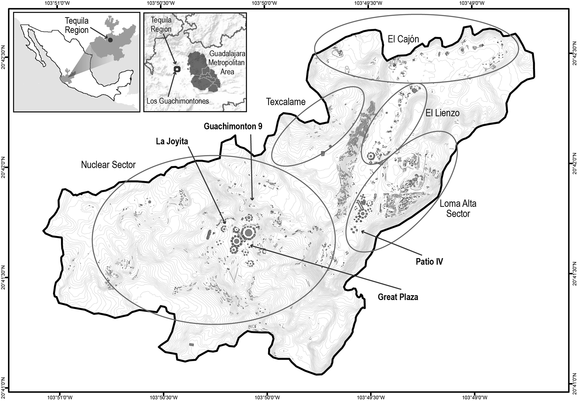
Los Guachimontones was the largest and most complex settlement in the Tequila region of Western Mesoamerica (Figure 1). It contains circular architectural complexes known as guachimontones, as well as ballcourts, shaft tombs, and patio groups—all quintessential features of the Tequila II–IV phases (350 BC–AD 500) and the Teuchitlán culture (Englehardt et al. Reference Englehardt, Heredia Espinoza, Cardona Machado, Heredia Espinoza, Englehardt and Cardona Machado2018). Los Guachimontones is considered to have been the political capital of a complex polity centered south of the Tequila volcano, as well as the religious center for the entire Tequila region and possibly beyond (Heredia Espinoza Reference Heredia Espinoza2017; Weigand Reference Weigand, Mastache, Cobean, Cook and Hirth2008:577, 583). More than two decades of field and laboratory work have demonstrated that political-economic strategies at Los Guachimontones were in line with some of the premises of corporate strategies and collective governance (Beekman Reference Beekman2008; DeLuca Reference DeLuca, McCurdy and Abrams2019; Fargher et al. Reference Fargher, Heredia Espinoza and Torres2014; Heredia Espinoza Reference Heredia Espinoza2019; Muñiz García Reference Muñiz García2017; Sumano Reference Sumano Ortega2016). Based on collective action theory and its implications for the intrasite spatial arrangements of urban settlements, I hypothesize that Los Guachimontones should exhibit an urban landscape that reflects the presence of collective goals that penetrated deeply into the social fabric (e.g., neighborhoods). That is, I will be able to identify centrally instituted ISUs that mediated between government and population as part of broader or larger-scale strategies adopted to provide public goods while also encouraging people's compliance with revenue collection. Public goods include roads, water facilities, market services, public feasting, and large open and accessible spaces such as plazas that are connected to road networks and are independent and separated from elaborate private residences (Fargher et al. Reference Fargher, Blanton, Antorcha Pedemonte, Truex and Pacifico2019:Table 11.2). I also consider the alternative hypothesis that political-economic strategies were comparatively lacking in collectivity. In this case, the built landscape will exhibit a limited supply of the public goods just mentioned, and ISU development may be organized bottom up to solve urban social problems. To test these hypotheses, I use the widely known guachimontón complexes, a pervasive type of public architecture in the Tequila region, to explore intrasite spatial configuration. My map of Los Guachimontones allows me to analyze its internal structure and how it relates to the larger political organization of the site.
Map of Los Guachimontones showing the names of the sectors and architectural complexes mentioned in the text.

Collective Action Theory
Basic Tenets
Application of collective action theory in anthropological archaeology has led to important contributions to our understanding of variation in complex sociopolitical organizations (Blanton and Fargher Reference Blanton and Fargher2008; Carballo Reference Carballo2013; Fargher and Heredia Espinoza Reference Fargher and Espinoza2016). This approach posits that all governments are the result of cooperation and negotiation between rulers and ruled (Blanton and Fargher Reference Blanton and Fargher2008). Cooperation and negotiation can be placed on a continuum from low to high. This variation results in a diverse array of sociopolitical formations that leave distinct archaeological remains. Governments that exhibit comparatively high degrees of collectivity share features such as the bureaucratization of power and authority, widespread distribution of public goods, investment in social capital on the intermediate socio-spatial scale, and inclusive ideologies that should result in fairness and benefits for all (Fargher et al. Reference Fargher, Blanton, Antorcha Pedemonte, Truex and Pacifico2019:161). The bureaucratization of power also implies the creation and implementation of an administrative apparatus that monitors and supervises people but, at the same time, has built-in mechanisms that allow the population to monitor its leaders and bureaucrats. This bureaucracy also ensures the fair distribution of public goods to the population and the collection of taxes and tribute from them. A good example of a collective government, in which people monitored its leaders, is ancient Tlaxcallan. Archaeological research and ethnohistoric documents demonstrate that Tlaxcaltecas enjoyed a variety of public goods, social mobility, and access to luxury goods and high-quality obsidian (Fargher et al. Reference Fargher, Blanton and Heredia Espinoza2010, Reference Fargher, Blanton, Heredia Espinoza, Millhauser, Xiutecuhtli and Overholtzer2011; Millhauser et al. Reference Millhauser, Fargher, Heredia Espinoza and Blanton2015). The investment of power and authority involved highly elaborate rituals in which leaders were subject to harsh treatment from the people (Fargher et al. Reference Fargher, Blanton and Heredia Espinoza2010). Enjoying a high quality of material life and the widespread public goods was an indicator by which Tlaxcaltecas monitored their leaders, because those goods were the material expression that the resources extracted from them in taxes and tribute were being used to benefit the population at large. Important to my argument is that collective governments invest in the built environment through the construction of intermediate administrative offices that facilitate communication between government officials and the general population. Collective governments are costly to build and maintain because they require the creation and implementation of an administrative apparatus that permeates all social scales (Blanton and Fargher Reference Blanton and Fargher2008:276, 278; Fargher et al. Reference Fargher, Blanton and Heredia Espinoza2010).
Materialization of Collective Government in Urban Settlements
Archaeologists recognize great variation in the spatial layout of large settlements and cities but have also identified cross-cultural parallels (Blanton Reference Blanton1978; Blanton with Fargher Reference Blanton and Fargher2016:165–190; Carr and Hazard Reference Carr and Hazard1961; Forest Reference Forest, Albiez-Wieck and Roskamp2016; García Cook Reference García Cook, Sanders, Mastache and Cobean2003; Heredia Espinoza Reference Heredia Espinoza2007; Hirth Reference Hirth, Sanders, Mastache and Cobean2003; Millon Reference Millon1973; Pérez Rodríguez et al. Reference Pérez Rodríguez, Anderson and Neff2011; Pollard Reference Pollard1977, Reference Pollard, Sanders, Mastache and Cobean2003; Smith Reference Smith2007). Some cities are radial, others are laid out on a grid, and still others do not follow either pattern (Blanton and Fargher Reference Blanton and Fargher2011; Blanton with Fargher Reference Blanton and Fargher2016:165–190; Fargher et al. Reference Fargher, Blanton, Antorcha Pedemonte, Truex and Pacifico2019; Pugh and Rice Reference Pugh and Rice2017; Smith Reference Smith2007; Weigand Reference Weigand, Foster and Weigand1985). The lack of some preconceived plan, however, does not necessarily translate into a chaotic spatial architectural arrangement. Some settlements display a palimpsest of layouts, the result of thousands of years of occupation and varying forms of social and political organization. A city's layout can be “read” because it is the result of government policies and people’s initiative to create middle-ground institutions (bottom-up/top-down processes); its layout can also be the outcome of factional competition (top-down processes) or the lack of government involvement in the configuration of settlements (bottom-up processes).
The distribution of types of architecture and the availability of public goods across an urban landscape shed light on the impact that collective state policies have had on the structure of that settlement. Top-down creation of ISUs entails little intervention of governing authorities to build facilities that promote and foster supervision over the populace; rather, it is a process through which factions or powerful individuals create sectoring and segregation. Sectoring could be based on these individuals’ houses or palaces—creating house clusters (followers) around elite residences—and public goods are few and far between. This pattern is emblematic of decentralized segmentary governments (Blanton and Fargher Reference Blanton, Fargher, Charlotte Arnauld, Manzanilla and Smith2012:31–34; Fargher et al. Reference Fargher, Blanton, Antorcha Pedemonte, Truex and Pacifico2019:166). Top-down/bottom-up processes imply a reciprocal and mutually beneficial relationship between rulers and ruled that results in ongoing negotiations between people and political officials. This means that government, through its rulers and administrators, will provide the infrastructure to facilitate communication in exchange for the people's support. Thus, this process should be manifested spatially in a multiplicity of public goods and administrative offices (administrative architecture) that promote communication and trust between the government and the people. Finally, bottom-up creation of ISUs may be the result of low collectivity or little state involvement (Fargher et al. Reference Fargher, Blanton, Antorcha Pedemonte, Truex and Pacifico2019). People create and organize neighborhoods as a means to solve common problems and provide mutual support (material or social). Because these aggregations are autonomous to some extent, they can be closed to outsiders, or access may be regulated. They may also be fortified, walled, or separated from each other by moats and bridges. In this scenario, public goods, if any, will be few and far between or restricted to the population within each ISU. In essence, bottom-up responses will manifest in ad hoc local solutions with no standardization and will show less interest in connecting the local to the larger system; in fact, they may even attempt to inhibit this connection.
Assessing the Degree of Collectivity and the Built Environment on the Intermediate Scale
In societies where collective action prevails, Blanton and Fargher (Reference Blanton, Fargher, Charlotte Arnauld, Manzanilla and Smith2012) and Fargher and colleagues (Reference Fargher, Heredia Espinoza and Torres2014, Reference Fargher, Blanton, Antorcha Pedemonte, Truex and Pacifico2019:160) hypothesized that institutions that invest in social capital on intermediate socio-spatial scales will develop infrastructure consistent with the implementation of collective strategies designed to achieve social integration and provide administrative services, including tribute collection, public participation, and the ability to monitor the behavior of government administrators. As noted earlier, ISUs are those social or political units or both situated hierarchically between the household or house cluster and the highest level of the political structure. They take the form of territorial or geographic subdivisions of an urban landscape (Fargher et al. Reference Fargher, Heredia Espinoza and Torres2014, Reference Fargher, Blanton, Antorcha Pedemonte, Truex and Pacifico2019). The development of these units may signal the implementation of channels that connect authorities to the people and other relevant issues related to political and economic organization.
My focus here is on neighborhoods and districts, two important kinds of ISUs. Districts are larger subdivisions in a city and provide diverse services over a larger range (administrative, economic, and religious), whereas neighborhoods are smaller, more socially oriented subdivisions (Smith Reference Smith2010:139–140; Smith and Novic Reference Smith, Novic, Arnauld, Manzanilla and Smith2012:4–5). Neighborhoods are made up of people living near a certain place or within a certain range. They are informal social units based on interaction: neighborhoods in the social sense (Feinman and Nicholas Reference Feinman, Nicholas, Charlotte Arnauld, Manzanilla and Smith2012:133, 138; Hendon Reference Hendon, Charlotte Arnauld, Manzanilla and Smith2012:160; Mumford Reference Mumford1954:257). They leave tangible material evidence in the archaeological record (Fargher et al. Reference Fargher, Blanton, Antorcha Pedemonte, Truex and Pacifico2019:Figure 11.2).
Review of Field Research at Los Guachimontones
For many years Los Guachimontones has captured the attention of scholars because of its scale and architecture. In the early twentieth century, Adela Breton (Reference Breton1903) depicted the most massive structures. Seven decades later, Joseph Mountjoy and Phil Weigand (Reference Mountjoy and Weigand1975:354–355) published a more complete sketch map and described Los Guachimontones as a settlement covering more than 6 km2. In the 1970s and 1980s, Weigand (Reference Weigand and de Méndez1990) carried out extensive reconnaissance south of the Tequila volcano, identified selected sites north of it, and sketch-mapped the Nuclear and Loma Alta sectors (Weigand Reference Weigand1993:26, 59). Subsequently, Smith Márquez (Reference Smith Márquez2009:132–137) produced a more detailed map with a total station that included the better-preserved public and largest residential architecture but overlooked more modest remains. In 2013, I began a project to investigate Los Guachimontones in its entirety (Heredia Espinoza and Sumano Reference Heredia Espinoza2017; Heredia Espinoza et al. Reference Heredia Espinoza, Martínez Rojo and Cortés Guzmán2013) by implementing an intensive full-coverage survey strategy that covered 5.6 km2; during that survey we identified and mapped thousands of architectural features that reveal the true complexity of architectural arrangements and the occupational history of the site (Figure 1; Heredia Espinoza Reference Heredia Espinoza2019). My discussion is based on my map, the most complete to date because it includes the totality of civic-ceremonial and domestic architecture.
Fieldwork Procedures
During a series of survey campaigns between 2013 and 2017, we applied an intensive site survey method at Los Guachimontones. Surveyors walked between 10 and 20 m apart, locating and drawing all standing architecture using a submeter-accurate GPS with real-time correction. In the field we recorded different categories of architecture, including 25 guachimontones,Footnote 1 four ballcourts, patio groups, and thousands of other features such as platforms, structures, terraces, alignments, banquettes, and steps. We classified these elements broadly as public, domestic, or other. Public architecture includes guachimontones, plazas, and ballcourts. Domestic architecture, drawn as polygons or lines, includes clear rectangular structures, terraces, or platforms associated with domestic debris such as ground stone, ceramics, and chipped-stone lithics. Other architecture includes features such as alignments and terraces of unknown function. In addition, we noted and photographed diagnostic ceramics, figurines, lithics, and artifacts like prismatic blades, which are chronologically sensitive (Esparza and Ponce Reference Esparza López, Ponce Ordaz, Williams, Weigand, Mestas and Grove2005:150; Mireles Reference Mireles, Espinoza, Englehardt and Cardona Machado2018). These data allow relative dating through the identification of specific chronological markers across the site.
Previous Spatial Analyses at Los Guachimontones
A previous version of the map was used for the three main published spatial analyses at Los Guachimontones, all of which dealt with the connection between the built environment and the political organization. A comparative paper on Mesoamerican cities analyzed the degree to which collective action affected the configuration of urban spaces in terms of transportation networks, public spaces, and neighborhood-scale administration (Fargher et al. Reference Fargher, Heredia Espinoza and Torres2014). It concluded that Los Guachimontones exhibited numerous accessible public spaces, such as temples and plazas, presiding over private, restricted architecture. In addition, there was limited manifestation of overt wealth inequality and little indication of personal aggrandizement. This preliminary work was further expanded by later spatial analyses at the site.
Kimberly Sumano's (Reference Sumano Ortega2016) space syntax analysis in both the Nuclear and Loma Alta sectors examined accessibility patterns and whether more exclusionary or more corporate strategies (following Blanton et al. Reference Blanton, Feinman, Kowalewski and Peregrine1996) played out differently in the two areas. Her results showed that the Nuclear sector was more public and open, allowing greater freedom of movement, whereas Loma Alta was more private and secluded, being harder to access. Presumably, these differences can be partially attributed to the functions and services that each provided: a largely public Nuclear area versus a residential Loma Alta precinct (see also Weigand Reference Weigand, Mastache, Cobean, Cook and Hirth2008). Although on the surface this layout may suggest a difference in strategies, Sumano concluded that, overall, corporate political strategies were dominant.
David Muñiz García (Reference Muñiz García2017) examined the relevance of open spaces such as plazas and patios to the organization of space at Los Guachimontones. Based on qualitative and quantitative variables, he distinguished nine sectors, each of which contained an equivalent number of public (plazas) and private (patios) spaces. Plazas and patios were distinguished by size (plazas covered more than 700 m2, whereas patios were below this threshold). His analysis also revealed that each sector contained at least one guachimontón complex, further suggesting that the site was organized into areas that included different architectural types offering a variety of religious and administrative services. Based on topography, Muñiz García (Reference Muñiz García2017:152) also projected the existence of three classes of paths: primary, which connected civic-ceremonial spaces; secondary, which branched off from primary paths and led to residential sectors; and minor paths, which connected domestic groups within residential sectors. These analyses indicate a well-connected settlement with plenty of public spaces.
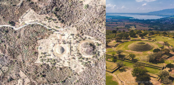
In sum, various independent spatial analyses indicate that, at the site scale, Los Guachimontones exhibits a spatial arrangement marked by multiple public, accessible spaces and a relatively high degree of openness consonant with a landscape that reflects collective policies. This article seeks to test whether collective policies penetrated deeper into the social fabric of the city by examining whether it is divided into ISUs (districts and neighborhoods) that reflect top-down/bottom-up collective goals. To accomplish this, I selected guachimontón architecture as the baseline for the spatial analysis. Guachimontones are complexes of circular public architecture composed of a central circular platform (or altar) surrounded by a circular patio ringed by several platforms (Figure 2; Weigand Reference Weigand1996:94). They are the typical public architecture of the region, a hallmark of the Teuchitlán culture, and an important element in discussions of political organization. The number of platforms in a guachimontón varies (4, 8, 10, 12, 16) and is statistically correlated to its size (diameter)Footnote 2: the eight-platform guachimontón form is the most common (Heredia and Beekman Reference Heredia Espinoza and Beekman2021).
Partial aerial view of the Los Guachimontones Nuclear sector (left) showing Ballcourt 2 and guachimontón 6, Ballcourt 1, guachimontón 4 north of Ballcourt 1, Great Plaza south of Ballcourt 1, and guachimontón 4 southwest of guachimontón 2 (photograph courtesy of Sebastian Albachens). Landscape view of guachimontón 2 (right), looking south toward the La Vega reservoir (photograph courtesy of Lic. María Ramírez Ramírez and Dra. Estefanía Hurtado Llanes @DroneTuVuelasYoVoy 01.11.2020). (Color online)

The meaning and function of the guachimontones continue to be a focus of archaeological interpretations, because they are a pervasive feature of the period and recur throughout the Tequila region and beyond (Weigand Reference Weigand, Williams, Lorenza López Mestas and Esparza2009:60–61). Christopher Beekman (Reference Beekman2003a, Reference Beekman2003b) interprets the guachimontón as the embodiment of the cosmos. Eight-platform guachimontones, he argues, represent the eight-row maize cob (harinoso de ocho) common in Western Mesoamerica (Beekman Reference Beekman2003a, Reference Beekman2003b; Beekman and Baden Reference Beekman, Baden, Williams and Weigand2011). Thus, they are strongly associated with themes involving harvests, fertility, nature, and cosmology, all of which can be related to corporate strategies (following Blanton et al. Reference Blanton, Feinman, Kowalewski and Peregrine1996). In contrast, Weigand (Reference Weigand1996) interprets the guachimontones as arenas for a flyer-type (volador) ritual.Footnote 3 Finally, based on an analysis of ceramic dioramas that depict rituals and scenes from daily life, Kristi Butterwick (Reference Butterwick1998:293) suggests that guachimontones were locations where public and private ritual feasting took place repeatedly. The common thread in these interpretations is that guachimontones are public spaces temporarily occupied by leading families to attend to affairs that fostered community integration and cooperation (Beekman Reference Beekman, Fargher and Heredia Espinoza2016:66–68; Heredia Espinoza Reference Heredia Espinoza, Englehardt, Espinoza and Beekman2020:250; Weigand Reference Weigand1996). Essentially, guachimontones had both religious and administrative functions. Hence, guachimontón architecture occupied a central role in community life throughout the region. They are the equivalent of public architecture found in other parts of Mesoamerica, and I argue that their recurrence may have been an important component in the spatial urban design at Los Guachimontones. Specifically, they may have served as key loci for the division of the site into ISUs.
Spatial Structure of Los Guachimontones during the Tequila II–IV Phases
Archaeologists use various analytical and statistical analytical tools to delimit territories, political boundaries, and areas of influence at regional and site scales (Chase Reference Chase2016; Ducke and Kroefges Reference Ducke, Kroefges, Posluschny, Lambers and Herzog2008; Hare Reference Hare2004; Heredia Espinoza Reference Heredia Espinoza2017; Prufer and Thompson Reference Prufer and Thompson2014; Stoner Reference Stoner2012; Thompson et al. Reference Thompson, Meredith and Prufer2018). I tested several methods in ArcMap (version 10.3) to determine whether guachimontones were central to the organization of space in the form of ISUs. The nearest-neighbor analysis approach proved to be inadequate for the purposes of this article, because it only shows whether architectural elements are distributed in a clustered, regular, or random manner but says little about what areas the guachimontones are servicing.Footnote 4 Hot spot analysis is a visual test developed to show areas of high concentration of architecture (domestic or public) but, like the nearest-neighbor approach, is limited in its usefulness for the objectives of this study because it is concerned primarily with the density of architecture.Footnote 5 Finally, I ran a visibility test from each of the guachimontones, taking into consideration topography, but this type of analysis is unable to deal with the way people perceive things. For example, dwellers in a certain part of Los Guachimontones could feel close to a guachimontón even if it were uphill and they and their neighbors could not see it directly from their patios, though it may be only 30 m away and they could walk to it in a few minutes.
The evaluation of these different methods in relation to the hypothesis of the article clearly indicated the need for a different type of test. Thiessen polygons seemed like a promising option for dividing the territory based on a selected feature (e.g., guachimontones). More sophisticated methods, such as weighted Thiessen polygons, consider a value or weight, such as guachimontón size, to create areas of influence or areas that were under the control of a certain feature. This technique, however, does not assess the primary hypothesis presented in this article. For these reasons, I decided to use a combination of Thiessen polygons and qualitative methods.
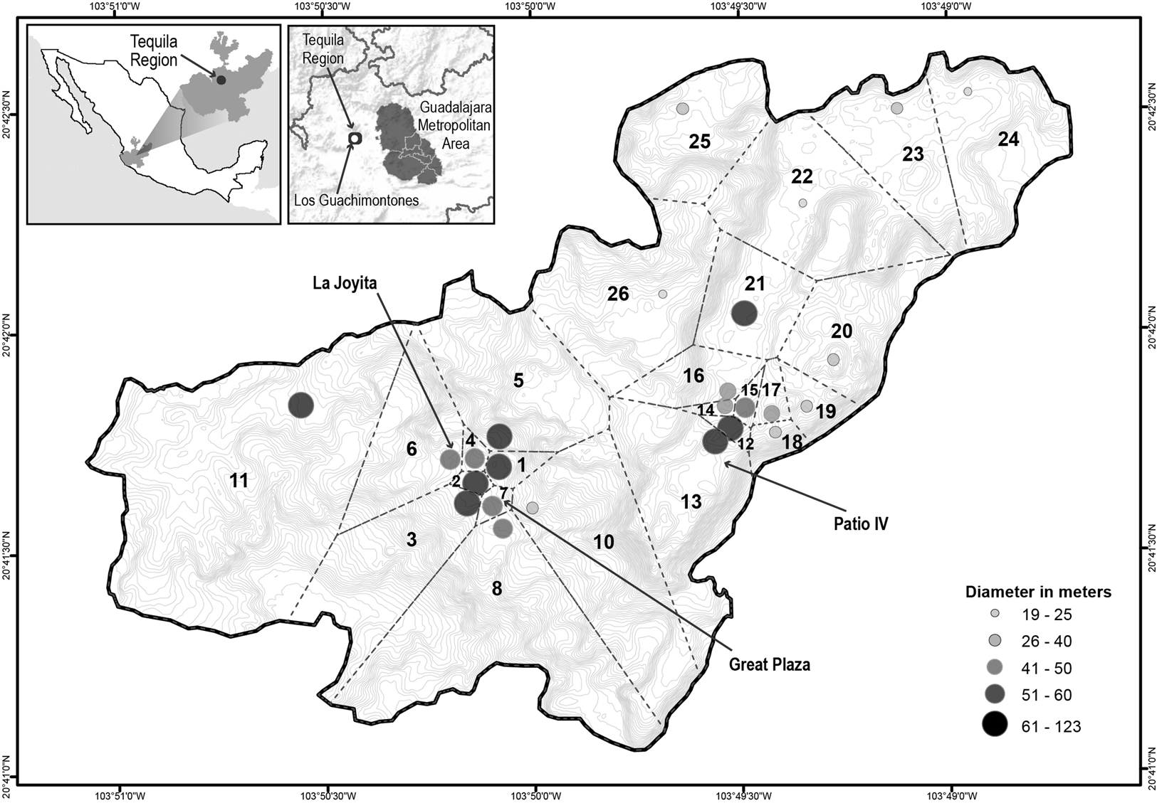
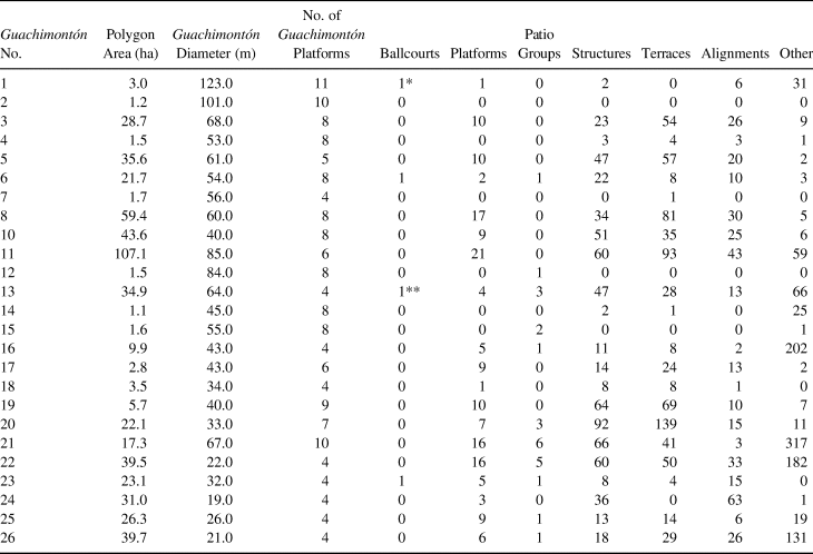
Using ArcMap version 10.3, I ran a Thiessen polygon analysis using the midpoint of each guachimontón (e.g., the central altar or the center of the patio). This method produced a map divided into 25 polygons (Figure 3), each of which includes all the architecture closest to each guachimontón; this map distinguished areas with specific suites of architectural forms (Table 1). Thus, taking account of all the architecture in each polygon and in the vicinity of each guachimontón allowed me to interpret them as potential ISUs. I describe the results in the following section.
Thiessen polygons at Los Guachimontones showing guachimontón diameters.

Architectural Elements by Guachimontón/Polygon Number with Descriptive Data.

* Ballcourt is shared among guachimontones 1, 2, and 4.
** Ballcourt shares a feature with guachimontón 12, but falls within guachimontón 14 polygon.
Results and Interpretations
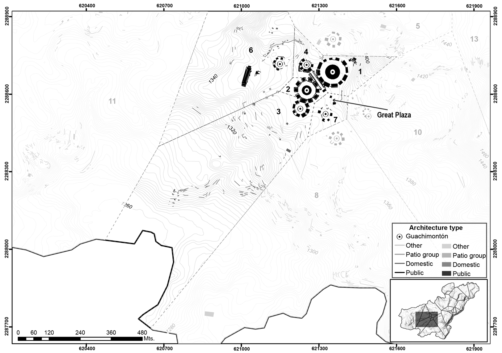
The quantitative spatial analysis and qualitative assessment based on guachimontón architecture distinguished three main patterns: (1) densely packed civic-ceremonial areas with scattered or no residential architecture, (2) densely packed and dispersed residential architecture with guachimontones, and (3) civic-ceremonial precincts associated with sparse residential architecture.
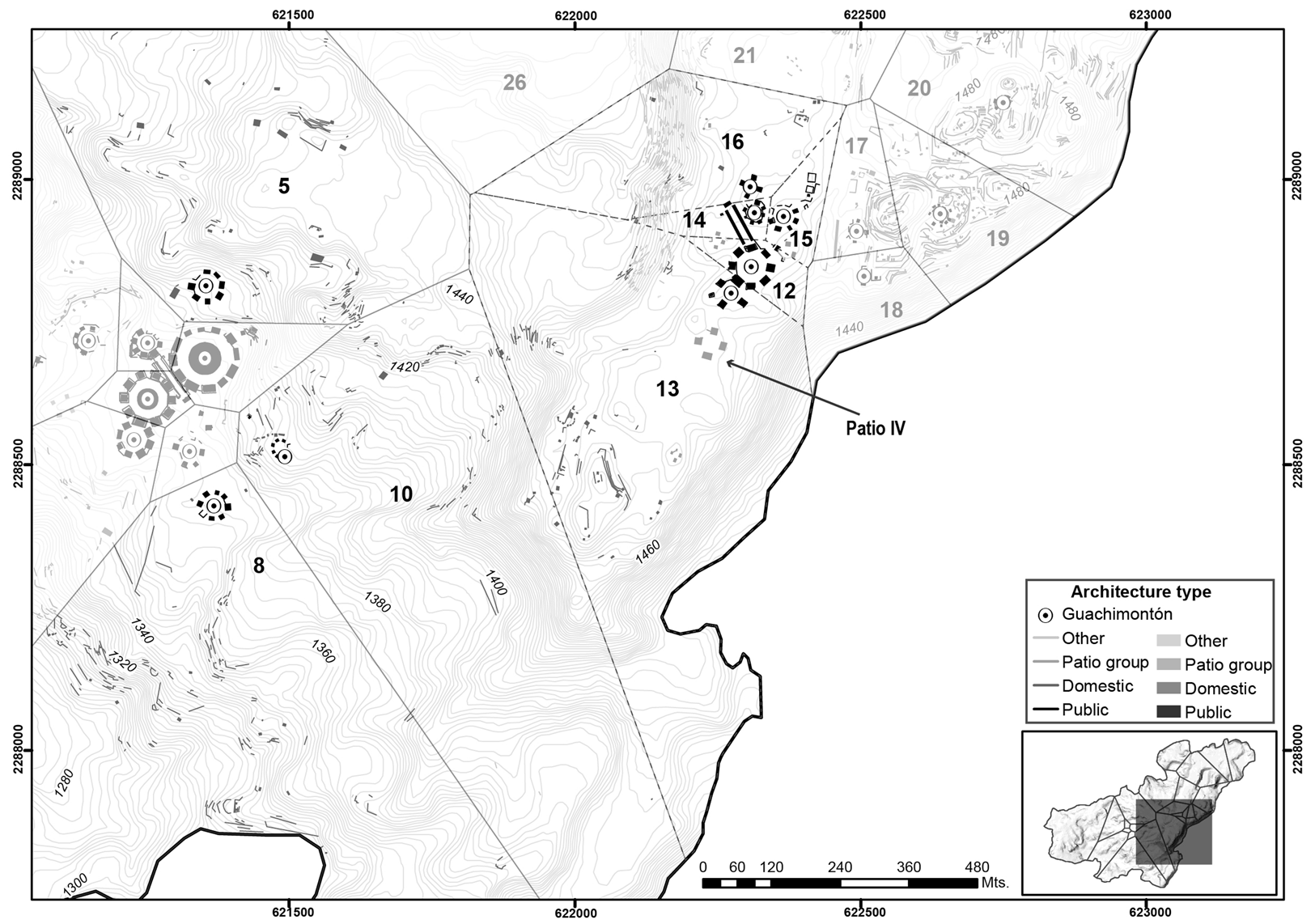
The first pattern is illustrated by the Nuclear and Loma Alta civic-ceremonial sectors (Figures 4 and 5), which encompass several polygons (P) and constitute somewhat similar architectural arrangements. Both sectors have a dense concentration of large guachimontones alongside ballcourts and formal patio groups, with scant residential architecture (Table 1). These guachimontones constitute a distinct sector; they are assemblies of public goods in the form of spaces devoted to community or region-wide public festivities and where the highest-level political events were enacted. The Nuclear sector seems to fit Smith's (Reference Smith2010:138) definition of a civic-ceremonial zone: areas “with concentrated public architecture . . . consisting of a number of public or monumental buildings and formal open spaces that may or may not contain residences, and where the latter is smaller than the public precinct.”
Nuclear sector.

Loma Alta civic-ceremonial sector.

P3 (Figure 4), P5, P8, and P10 (Figure 5) in the Nuclear sector include more residential architecture (Table 1) and appear to have provided more than just public or civic-ceremonial services. In the case of P3, the guachimontón is embedded within guachimontón 2, so it forms part of the civic-ceremonial core. Most of the residential architecture runs downhill from this feature. This is also the case for P3, P5, P8, and P10, which contain dispersed residential architecture. Their nearness to each other (no more than 100 m) suggests that these guachimontones are part of the civic-ceremonial core, and not necessarily the hub of an ISU. There are no natural (e.g., canyons) or cultural (such as intentionally built walls) barriers that impede movement. Additionally, the surface survey indicates that the architectural features farther away from the guachimontones, especially for P3 and P8, have predominantly a Postclassic occupation.
Loma Alta's civic-ceremonial core resembles the Nuclear sector but differs in scale (Figure 5). It contains five guachimontones, a ballcourt, and patio groups. P12, P14, and P15 show very few traces of residential architecture, whereas P13 and P16 include more. P13 comprises a four-platform guachimontón located close to an unusually large and potentially high-status residence, Patio IV (Figure 5). Patio IV and the rest of the residential architecture are separated by a large open and relatively flat area, perhaps a plaza. This group resembles P3, P8, and P10 in the Nuclear sector where the guachimontón is closer to the core of the civic-ceremonial cluster than to the domestic architecture. P16 is focused on a four-platform guachimontón and includes some residential architecture that suggests a wider array of services compared to the larger guachimontones nearby (Figure 5; Table 1). Again, there are no evident natural or cultural barriers that hamper movement.
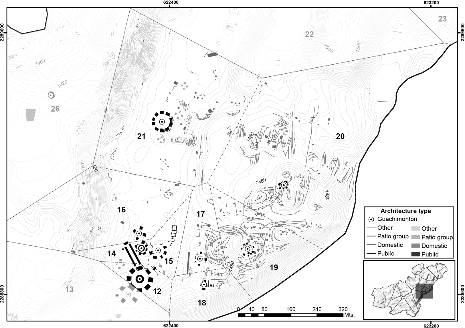
The second pattern may be seen in P17–P20 in Loma Alta and P21 in El Lienzo. Here guachimontones are interspersed with densely packed or dispersed residential architecture (Figure 6). P17–P20 contain guachimontones surrounded by densely packed residential architecture that include patio groups, platforms, structures, and terraces (Table 1). No other civic-ceremonial architecture such as ballcourts appears. This is an accessible area with gentle knolls and dense domestic features. El Lienzo (P21; Figure 6) is in an open space with no apparent cultural or natural impediments to movement. P21 is a well-defined cluster of residences, platforms, and terraces associated with a 10-platform guachimontón (Table 1). This cluster contains several patio groups that may signal high-status formal residences.
Loma Alta residential and El Lienzo sectors.

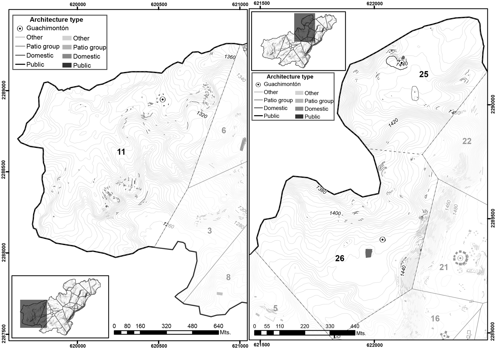
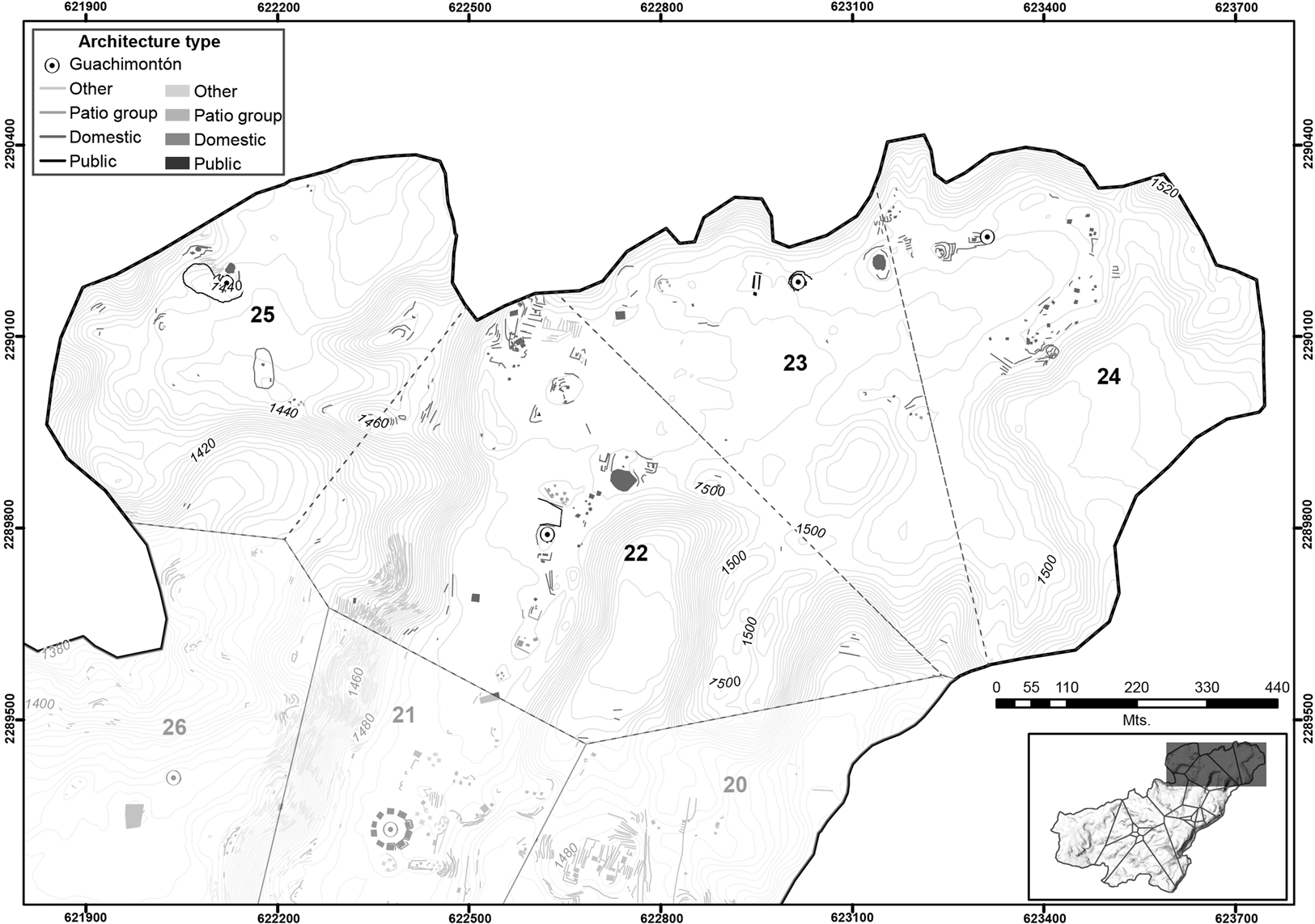
Dispersed architecture surrounding a guachimontón is exemplified by P11, P22 (El Lienzo), P24 (El Cajón East), P25 (El Cajón West), and P26 (Texcalame). P22 and P24 include dispersed residential architecture associated with four-platform guachimontones (Figure 7; Table 1). P11, P25, and P26 are separated topographically from other sectors, and were occupied by fewer people (Table 1; Figure 8). P11 contains an array of different types of residential architecture associated with a deflated eight-platform guachimontón. No patio groups or ballcourts are associated with it. P25 contains a four-platform guachimontón in the vicinity of a small amount of dispersed residential architecture. Finally, P26 (Texcalame) includes a small four-platform guachimontón, a large patio group on a platform, and little residential architecture. Despite being in different areas and separated by topography, these sectors are not cut off from one another by big walls or impassable canyons.
Guachimontón 11 in Nuclear sector (left), guachimontón 25 in El Cajón west (upper right) and Texcalame (lower right).

El Cajón sector.

The third pattern—civic-ceremonial precincts associated with sparse residential architecture—is illustrated by P6 (Figure 3) in the Nuclear sector and P23 at El Cajón (Figure 7). These two, however, vary in scale and in the character of their surroundings. P6 contains the oldest dated residential architecture, along with a large ballcourt and an eight-platform guachimontón with dispersed architecture. It is isolated from residential architecture and is more closely associated with the Nuclear sector. P6 presumably served mostly religious-administrative functions, even though it was not located at the center of a neighborhood or district. Contrasting with this pattern, P23 contains a four-platform guachimontón, a ballcourt, and little residential architecture. In this case, the guachimontón and ballcourt are at the center of the larger El Cajón sector, suggesting a wider array of functions. P23 may have served the surrounding population as a small-scale district offering a full range of administrative and ceremonial services, as well as residential functions. The scale of the civic-ceremonial architecture (ballcourt and guachimontón) highlights its secondary position to Loma Alta. Once again, this ISU correlates with a top-down/bottom-up approach in which the public goods that materialized in the guachimontón and ballcourt were available to the surrounding residents. This entire sector is open and accessible.
The results of these analyses indicate that Los Guachimontones was indeed divided into sectors, some of which can be identified as ISUs in which guachimontones played a key role in the organization of space, though the spatial arrangement is more complex than we expected. In the next section I compare the findings with the expected patterns as dictated by collective action theory.
Discussion
Past research indicates that the Teuchitlán culture and Los Guachimontones exhibit many of the attributes associated with corporate strategies and collective governance. This article set out to inquire further into how the built environment reflects how deeply collective policies had penetrated into people's lives. Focusing on guachimontones, the central hypothesis of the study was that they would be a key factor in the organization of space that created or supported ISUs that resulted from bottom-up/top-down processes. I also considered these alternative hypotheses: (1) that ISUs arose as a top-down process whereby powerful factions or families created a following around their residences or (2) that these ISUs were the outcome of a bottom-up process with little government involvement. The results of the analyses presented here indicate that the built environment at Los Guachimontones was overwhelmingly the result of bottom-up/top-down processes, given what we know about guachimontón functions, their standardized nature, the way that settlement growth is associated with them, and the fact that barriers to movement are rare to nonexistent. However, the patterns determined turned out to be more complex than anticipated.
The Nuclear and Loma Alta sectors exhibit areas with dense public goods, such as guachimontones, plazas, and ballcourts, which point to a more public character for these sectors. They are not ISUs in the form of neighborhoods or districts, properly speaking. Close inspection and analysis, however, highlight significant differences between the two sectors. The Nuclear sector is overwhelmingly public, with perhaps a few guachimontones serving more as the hubs of neighborhoods (P5, P8, P10, and P11). P6 contains a whole set of public architecture along with the oldest dated residences (La Joyita), as well as a large ballcourt, an eight-platform guachimontón, and dispersed architecture. It is isolated from the residential spaces and is like the Nuclear sector, which offers overwhelmingly religious-administrative services but is not at the center of a neighborhood or district. In contrast, P11 has a clearly demarcated neighborhood.
Loma Alta has a concentration of public goods including a cluster of guachimontones and a ballcourt but is more secluded. Given the architectural diversity represented by the ballcourt, the multiple guachimontones, and the patio groups, I propose that the Loma Alta was the hub of an entire administrative district serving the Loma Alta residential sector, El Lienzo, and El Cajón. Thus, the entire ridge included multiple ISUs defined by the occurrence of a guachimontón and surrounding residential buildings, with a smaller-scale administrative ISU that included a ballcourt (P23, El Cajón) and attended to neighborhood affairs (P22, P24, and P25) in the northern limits of Los Guachimontones.
This ridge included multiple neighborhoods and two administrative ISUs in a nested spatial fashion. The Loma Alta civic-ceremonial center may well have acted as the main center of civic-ceremonial affairs. P23 at El Cajón would have dealt only with local matters as a subdistrict. I argue that Los Guachimontones is made up of a nested arrangement of public spaces and ISUs that serviced local and subregional or regional affairs. The scale and number of public architecture in the Nuclear sector indicated that this sector played a religious role extending beyond the site. Loma Alta, in contrast, was potentially a civic-ceremonial area that served as the seat of administration for the site. Loma Alta's provision of site-wide services and the Nuclear sector's service to the larger region suggest that Los Guachimontones had a dual core or decentralized organization at the highest tier. This conclusion stems from the diversity of architectural forms and sizes that represent distinct services (ISUs) for the surrounding population.
P25 and P26 are two somewhat isolated neighborhoods. I believe they are the product of different processes, given the architecture associated with them. P25 contains modest domestic architecture and other features, whereas P26 includes a large patio group on a platform that overshadows its small guachimontón to the east. P26 may be the only sector that indicates a top-down ISU in which a powerful family was able to garner the labor force required to build this large residence, which dwarfs the small-scale guachimontón to the west; perhaps this indicates the prominence of private versus public affairs. This, however, is a preliminary hypothesis that requires further testing.
Public goods in the form of guachimontones, plazas, and ballcourts were widely available at Los Guachimontones. I suggest that the presence of public architecture, rather than large private residences, indicates that a collective structure was in place on the site scale and that these results correspond to previous interpretations of the Teuchitlán culture in general (Heredia Espinoza Reference Heredia Espinoza, Englehardt, Espinoza and Beekman2020). An additional line of support for the collective character of the guachimontones derives from the organization of labor for their construction.
The construction techniques and raw materials used in building the guachimontones indicate that each one was built through a combination of individual and collective labor. Judging by the types of rocks and clay used and the quality of the construction, differences were noted in the platforms in a single guachimontón at Navajas, Llano Grande, and in guachimontón 2 at Los Guachimontones: these differences showed that different crews built each platform (Beekman Reference Beekman2008; DeLuca Reference DeLuca, McCurdy and Abrams2019; see also Mountjoy and Weigand Reference Mountjoy and Weigand1975:358). The patio, for example, shows more homogeneous layers in construction materials and methods, whereas the platforms show clear differences (DeLuca Reference DeLuca, McCurdy and Abrams2019). Hence, the participation of distinct groups is perceptible in the construction of a single circular complex.
Study of ceramic models from several sites suggest that ceremonial events, associated with integration strategies and community events, rather than individualizing or aggrandizing behaviors, took place in public spaces in the Tequila region (Weigand Reference Weigand1996). Some ceramic models portray people gathering in the patios for festivities that involved dancing to music and food consumption (Butterwick Reference Butterwick and Townsend2006:95–97; Townsend Reference Townsend and Townsend2006:113, Figure 27; von Winning and Hammer Reference Von Winning and Hammer1972). The various analyses of ceramics recovered from excavation concur with the models. The assemblages are dominated by large jars and undecorated serving ware, as opposed to individual, highly decorated bowls intended to exhibit wealth as a form of conspicuous consumption (Beekman Reference Beekman, Englehardt, Espinoza and Beekman2020:82–87; Johns Reference Johns2014; Tyndall Reference Tyndall, Weigand, Beekman and Esparza2008). The combination of both sets of data indicate that public ritual events and consumption of food took place inside guachimontones.
Los Guachimontones is the only site that has been excavated extensively in the Tequila region, and analyses of the chronological sequence are still in their infancy. Based on a series of methods that included architectural stratigraphy, radiocarbon dating, and analyses of excavated ceramic debris, figures, figurine fragments, and vessels from offerings, burials, and stratigraphic pits (Beekman Reference Beekman, Englehardt, Espinoza and Beekman2020:67), I am able to note some trends that illuminate the construction sequence. At Los Guachimontones, the first settlement was a household (La Joyita) currently understood as an elite residence (Herrejón Reference Herrejón Villicaña2008). This construction was followed by guachimontón 6, which contained various burials and a shallow shaft tomb. The burial offerings were comparatively modest and were interpreted as foundation rituals rather than family interments (Cach Reference Cach, Williams and Weigand2005:114). In the Loma Alta sector, Patio IV appears as the earliest construction, followed by guachimontones 12 and 13. Patio IV is a large, formal residential group that, given its size, represents a potential elite residence. The ceramic assemblage, however, does not provide any significant clues to differentiate this structure from the public architecture (Beekman Reference Beekman, Englehardt, Espinoza and Beekman2020; Esparza and Weigand Reference Esparza López and Weigand2008). The trend in the construction sequence, with the dates currently available at the site, begins with the establishment of a residence, followed by public architecture. Our current understanding is that these places were likely occupied by political leaders rather than elites attempting to co-opt a segment of the population. Support for this comes from follow-up studies of the construction of public infrastructure in the form of guachimontones and ballcourts, the absence of evident palatial edifices, the lack of overt conspicuous consumption (buildings and artifacts), and the pervasiveness of the public over the private. Wealth inequality, however, does not impede collective strategies, and being collective does not correspond to egalitarianism. Future controlled excavations in key areas will allow us to clarify these rough diachronic trends and obtain more fine-grained information on the diversity of constructions and their associated artifacts.
In summary, the compilation of various kinds of data used in this analysis indicates that guachimontones served varied purposes and, in conjunction with other types of architecture such as ballcourts, potentially suggest an additional layer of services. In general, based on the openness of the built environment and the lack of obvious natural barriers, the ISUs present at Los Guachimontones are the result of bottom-up/top-down strategies, whereby the guachimontones acted as places where interactions between the government and the people occurred. Further, their function as public and accessible spaces argues against a top-down approach. I propose that the only possible ISU that was the result of a top-down process is P26, where the patio group overshadows the small guachimontón.
Concluding Thoughts
This article set out to examine whether collective policies, evident on the site scale, penetrated deeper into the social fabric at the intermediate socio-spatial unit scale. Results indicate that collective policies did penetrate to the level of the neighborhood. The spatial analysis presented here reveals that Los Guachimontones was divided into neighborhoods and districts, as was the case of many other contemporary urban settlements in Mesoamerica (Blanton Reference Blanton1978; Gómez Chávez Reference Gómez-Chávez, Arnauld, Manzanilla and Smith2012; Pérez Rodríguez et al. Reference Pérez Rodríguez, Anderson and Neff2011). These neighborhoods were constructed through top-down/bottom-up strategies, indicating that collective forces were at work. The guachimontón was the basis for the organization of the site into neighborhoods, whereas the presence of ballcourts and large patio groups appears to be indicative of a higher administrative level of management, such as districts that attended to a larger population. The religious character of the guachimontón provided a way to integrate household clusters and was indeed a public good that served the entire population. The proximity of residential areas to one or more guachimontones indicates that people enjoyed easy access to them. In this sense, neighborhoods seem to have been tightly knit entities with common spaces for ritual, feasts, and community integration at the lowest level.
This pattern can be contrasted to places like the Valley of Oaxaca, where Classic period Monte Albán exhibited dense residential neighborhoods, each of which contained elaborate elite residences and palaces (Blanton Reference Blanton1978:75–93). Yet, each of these districts also had a plaza that was open and accessible. Hence, Monte Albán seems to take the middle ground in terms of collectivity, probably shifting to more elite-centric strategies in the Late Classic (Fargher Reference Fargher, Fargher and Heredia Espinoza2016). In contrast, the Mixteca Alta region reveals various clusters of architecture but little investment in public goods and infrastructure. Yucundaa, the capital of a small state, has a royal sector at the top of the hill that is walled off, surrounded by an elite sector below it and commoner residential area down from that (Spores and Robles Reference Spores and Robles García2007). Another example comes from Rio Bec, where sectors were focused on elite houses that were in competition and public space was inscribed within their residences (Nondédéo et al. Reference Nondédéo, Arnauld and Michelet2013). These patterns correlate best with a segmentary type of organization in which investment in labor is minimal in terms of public goods and public facilities and most major construction was private in nature (Fargher et al. Reference Fargher, Blanton, Antorcha Pedemonte, Truex and Pacifico2019).
The past, however, as evidenced by these data, is more complex than our models and theories have envisaged, because we also detected patterns on the site scale that indicate a hierarchical and nested order in the distribution of public architecture. Guachimontones represent the core of some ISUs that took the form of neighborhoods, whereas others emerged as districts due to their association with other civic-ceremonial architecture. Future studies should focus on the sequence of growth between public versus domestic/private spaces to further clarify the bottom-up or top-down development of Los Guachimontones; this focus will enhance our understanding of the way in which collective forces shaped and transformed this urban landscape. Current theory allows a better understanding of the nature of Los Guachimontones in terms of political economy and generates additional hypotheses to consider the guachimontón as an organizing architectural element in the life of the ancient Tequileños.
Acknowledgments
I would like to thank Lane F. Fargher, Stephen A. Kowalewski, Richard E. Blanton, and Christopher S. Beekman for reading an earlier version of this manuscript; their comments and suggestions enhanced it. Thanks to El Colegio de Michoacán, the Secretaría de Cultura del Estado de Jalisco, and the Teuchitlán municipality for providing the financial and infrastructural support to conduct the fieldwork. The Consejo de Arqueología, INAH, provided the necessary permits to carry out this research. I am grateful to the crew who participated in the survey and mapping at Los Guachimontones (Susana Meave, Iziar Martínez, Juan José Cortés Guzmán, Carolina Ramírez, Alex Navarro, and Alba Téllez). Jesús Medina Rodríguez from the Centro de Estudios de Geografía Humana (CEGH) at El Colegio de Michoacán crafted all the figures. I thank Carolina Arévalo Peranchiguay for acquiring the permits to reproduce the photographs shown in Figure 2. This article was strengthened by the comments of Lorenza López Mestas and three anonymous reviewers.
Data Availability Statement
No artifacts were collected in the field during the mapping and survey at Los Guachimontones; however, the 11-year excavated data (artifacts and osteological remains), maps, and analyses in digital from are housed at the archaeological laboratory in the Centro Interpretativo Guachimontones in Teuchitlán Jalisco. All data discussed in this article are available from the author.