Introduction
In 1919, the under-secretary of state at the British colonial office, Leopold S. Amery, after establishing that there was no policy regarding Antarctica, advised the colonial secretary, Viscount Milner, that Britain should assert its claim to the whole continent (Beck Reference Beck1983).
In pursuit of this policy, Australia gained sovereignty over a large sector of Antarctica in 1933. A. Grenfell Price, in describing the process by which this territory was gained in The winning of Australian Antarctica, contends that Australian Antarctic Territory (AAT) was ‘won’ by the Sir Douglas Mawson led British Australian New Zealand Antarctic Research Expeditions (BANZARE) against the ‘advance’ of Lars Christensen's ‘wealth-seeking’ Norwegian whalers who sought territory free of British control (Price Reference Price1962: 14, 168). Price (Reference Price1962: vii) justifies ‘recounting the battle which Mawson fought for Britain and Australia’ to counter the Norwegian version presented by historians Bjarne Aagaard (Fangst of Forskning I Sydishavet) and Hans Bogen (Main events in the history of Antarctic exploration).
This paper, using diplomatic correspondence, where appropriate expands on Price's version of the Norwegian whaling experience in Antarctica which drove Christensen to seek territory void of British control, and shows why the Norwegian whalers were justifiably ‘incensed by the extension of British jurisdiction over territory and whaling’ (Price Reference Price1962: 15, 17, 27). Relying on official documents, the paper examines the process devised at the 1926 Imperial Conference, to extend British jurisdiction over Antarctica, a process which led to the establishment of AAT. The implementation of this process is discussed stage by stage showing the effects of Norway's agreement to refrain from claiming territory of ‘special interest to Britain’ in return for Bouvet Island, the role played by Mawson and BANZARE and the influence of Norwegian whalers on that role. Finally, Norway's reaction to Australia's claim to Antarctic territory is presented.
The paper will show that the Norwegian Government, wishing to remain on friendly terms with Britain, provided tacit support to the claim by Britain to territory for Australia, support that was reciprocated by Britain. Given the relationship between the two countries, this paper will test Price's contention that Australian Antarctica was ‘won’.
Norwegian experience in British Antarctica
Norwegian whaling operations in the southern ocean started in 1904 when C.A. Larsen established an Argentine owned whaling factory on South Georgia. This was followed by Christen Christensen, whose factory ship Admiralen, commenced operations in the South Shetland Islands in 1905, just before Norway seceded from Sweden. Believing they were whaling in no-man's land, the Norwegian chargé d'affairs, London, wrote to the British foreign secretary enquiring about the sovereignty of territories, including the South Shetland and South Orkney Islands, in the area between longitudes 35°W and 80°W and latitudes 40°S and 65°S (Irgens Reference Irgens1906). He also asked if permission could be obtained to establish whale fisheries off the Falkland and South Georgia Islands. The letter generated a sequence of actions.
The first was a reply in May 1906 stating that South Georgia, South Shetlands, the South Orkneys and Graham's Land were dependencies of the Falkland Islands (Grey Reference Grey1906). This was followed by a new Falklands whale fishing ordinance setting an annual fee and limiting the number of licenses and areas in which each licensee could operate (Tønnessen and Johnsen Reference Tønnessen and Johnsen1982: 180). The ordinance required royalties to be paid on every whale killed inside or outside the territorial waters of the dependencies. Norwegian whalers were incensed by the claim for royalties on whales caught on the high seas, and the British claim to the islands and Graham Land (Aagaard Reference Aagaard1934: 864–866). This provoked another letter to Britain from Norway, asking since when had these areas belonged to Britain, on what international custom was the claimed sovereignty based and had the British government notified other countries that these areas were British (Légation de Norvege 1907)? The British foreign secretary replied in April 1907 stating that formal possession had been made by British ship captains on each island and Graham's Land, and that it was not British practice to notify foreign governments of additions to British territory (Grey Reference Grey1907). No mention was made regarding previous claims by other nationals, Norwegian or French. As Aagaard (Reference Aagaard1934: 866) observed ‘no doubt the British had rights to this area and as far as England was concerned no other country had rights.’
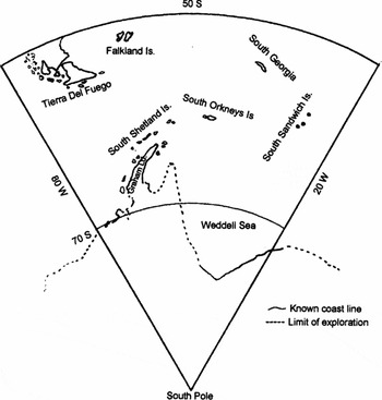
In July 1908 the British government formally claimed South Georgia, the South Orkneys, the South Shetlands, the South Sandwich Islands and Graham's Land all lying between 20°W and 80°W and south of 50°S by letters patent as dependencies of the Falkland Islands as shown in Fig. 1Footnote 1 (British Letters Patent 1908).
The Falkland Islands Dependencies as provided by British letters patent July 1908. The northern boundary through South America was changed by letters patent March 1917 to 58°S between 50°W and 80°W.

Britain's intentions
The establishment of Falkland Island Dependencies (FID) and the issue of whale fishery ordinances enabled Britain to control whaling and derive revenue from the industry. Control was necessary to prevent the exploitation which had seen northern whale stocks depleted. Following the 1914–1918 war, the strategic value of whale oil was fully realised as a source of glycerine, an essential item in the manufacture of explosives. The value of whale oil, both strategically and as a revenue source, and the realisation that this resource must be regulated to prevent exploitation to the point of extinction, resulted in the British colonial office formulating its first policy concerning Antarctica (Beck Reference Beck1983). The policy, based on experience in the FID and a realisation of the potential value of resources in Antarctica and the surrounding waters, convinced Amery and the colonial office, that these should be controlled by Britain (Beck Reference Beck1983). In 1920 Amery advised the governors general of Australia and New Zealand of Britain's intent to extend control over the whole of Antarctica as:
His Majesty's Government have . . . come to the conclusions that it is desirable that the whole of the Antarctic should ultimately be included within the British Empire, and that, while the time has not yet arrived that a claim to all continental territories should be put forward publicly, a definite and consistent policy should be followed of extending and asserting British control with the object of ultimately making it complete (Bush Reference Bush1982a: 104).
This statement is clearly an indication that the whole Antarctic continent, including French Adélie Land, which had already been claimed by France in 1912, should be part of the British empire. However complete domination was thwarted by the French in 1924, when a number of decrees were issued consolidating their claims to Adélie Land and the Iles Crozet, Kerguelen, Saint-Paul and Amsterdam and placing them under the administration of the governor general of Madagascar (Swan Reference Swan1961: 170).
In pursuit of Amery's Antarctic domination policy, the Ross Dependency was claimed by an order of the King in Council in July 1923 and placed under the control of the governor general of New Zealand. The area claimed included all islands and territories between the longitudes 160°E and 150°W and south of latitude 60°S. The claim to this territory, like that of the FID, had been precipitated by a Norwegian enquiry regarding whaling in the Ross Sea. The enquiry was made by C.A. Larsen in June 1922 after advice from the Norwegian minister in London. In December 1922, a licence was issued for whaling from the Balleny Islands to the waters adjacent to Victoria Land (Tønnessen and Johnsen Reference Tønnessen and Johnsen1982: 347). This was before Britain had claimed sovereignty over an area which the Norwegian ministry of foreign affairs believed to be no man's land. According to Tonnessen and Johnsen (Reference Tønnessen and Johnsen1982: 347), ‘Britain's action aroused a storm of fury among the general public in Norway.’ As Aagaard (Reference Aagaard1934: 873) asserted, once again the British had claimed an area of Antarctica because Norwegians were interested in whaling in that area; this time it was in the Ross Sea.
On learning of Britain's claim, the Norwegian minister in London, wrote to the British foreign secretary on 24 February 1925 querying the establishment of the Ross Dependency and voicing the Norwegian government's concern ‘that the annexation . . . may have the effect of jeopardising present or future Norwegian interests and rights’ (Vogt Reference Vogt1925). This and subsequent correspondence, after it was realised by Norway that this was a sector claim to the pole, detailed Norwegian rights with respect to the territories on either side of Amundsen's route to the South Pole, including the Queen Maud Range, and the polar plateau he had claimed and named for King Haakon VII (Vogt Reference Vogt1925). The British response stated that, based on discovery, the dependency was indisputably British and that Shackleton had claimed the plateau when less than 100 miles from the South Pole in 1909 (Chamberlain Reference Chamberlain1925). Britain was also advised that while Scott had sighted King Edward VII Land in December 1902, it had been formally claimed for Norway by Amundsen's second in command, Lieutenant Prestrud, in December 1911 while on a sledging journey to Scott's nunatak (Vogt Reference Vogt1927). Norway reserved her rights to the polar plateau and Amundsen's route between 120°W and 175°W and south of 85°S (Aagaard Reference Aagaard1934: 873). While the correspondence between Norway and Britain over claims in the Ross Dependency was taking place, the 1926 Imperial Conference was being held in London at which Amery's British Antarctic domination policy was being discussed.
The 1926 Imperial Conference
At the Imperial Conference, a process was formulated by the committee on British policy in the Antarctic to annex further territory in pursuit of the policy to claim the whole of Antarctica for the empire. Despite representations made by Norway over the establishment of FID and the Ross Dependency, the committee noted that ‘no protests were received against the assertion of British authority and sovereignty over these areas’ (Imperial Conference 1926). In keeping with this assumption, the committee recommended that a gradual process be followed for the acquisition of further territory as any attempt to do so by immediate acts of annexation of large sectors in the great part unexplored would probably lead to opposition on the part of other Powers who might be in a position to put forward claims to particular areas within those sectors’ (Imperial Conference 1926). The Committee believed that ‘if His Majesty's Government proceed cautiously, and steadily follow up and develop the valid claims they now possess, it may be hoped that foreign Powers will acquiesce, and that practically complete British domination may in time be established’ (Imperial Conference 1926). The process to achieve this was to be undertaken in three stages. The first was to list the seven areas of interest in the conference ‘Summary of proceedings’ by name only, no geographical limits were to be given. The second stage of the process was the formal taking of possession by an authorised officer of any areas not so taken at the time of discovery. The third stage was the annexation of the area and making provision for its government. This process, although it had not been followed in the acquisition of the FID or the Ross Dependency, was essentially in accordance with the requirements of contemporary international law (except for the requirement of permanent settlement)Footnote 2 to gain full title.
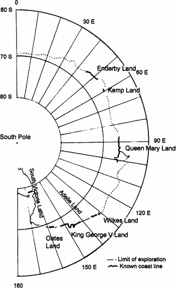
The areas of interest were described in the ‘Summary of proceedings’ as, ‘certain areas in regions to which a British title already exists by virtue of discovery’ (Imperial Conference 1926). While the geographical limits had been specified by the conference they were omitted from the summary. The seven areas were as follows (Fig. 2).
Part of Coats Land between longitude 20°W and longitude 161/2°W
Enderby Land between longitude 45°E and longitude 521/2°E
Kemp Land between longitude 581/2°E and longitude 60°E
Queen Mary Land between longitude 861/2°E and longitude 101°E
Eastern Antarctica showing the territories listed in the 1926 Imperial Conference summary without geographical limits.

An area between longitude 131°E and longitude 1351/2°E denominated Wilkes Land by the Australian Antarctic Expedition (AAE) in 1912 and west of Adélie Land.
King George V Land between longitude 142°E and longitude 153°E lying east of Adélie Land.
Oates Land between longitude 157°E and longitude 159°E
Except for Coats Land, these areas would be part of AAT. In publishing the areas of interest without their geographical limits, the committee hoped to limit challenges from other powers. As the areas were ill defined on maps of the day the extent of the claim was hidden. No mention was made of the large unexplored areas between Kemp Land and Queen Mary Land and between Queen Mary Land and Wilkes Land.
The second stage of the process, that of formal proclamation, would be made by the Mawson-led BANZARE but not before Norway had annexed and claimed Bouvet Island, an island Britain believed was its.
Lars Christensen and Bouvet Island
On 1 December 1927, Bouvet Island was claimed for Norway by the captain of Lars Christensen's Norvegia. Christensen, a Norwegian whaling magnate with an interest in oceanographic science, had spent time in London in 1926 and had written to the colonial and dominion offices regarding whaling in the vicinity of Dougherty Island, (later found to be non-existent). His enquiry regarding a licence was considered at the Imperial Conference and he was advised by the dominion office that the ‘sector between the Falkland Dependencies and west to Ross Dependency was under Great Britain and should be administered by New Zealand’ (Christensen Reference Christensen1935: 27–29). While this was in line with Amery's domination policy no claims had been made in this sector. Christensen did not proceed with whaling activities in this area. Given the Norwegian experience in the South Shetlands, South Georgia and the Ross Sea and concerns over the security of British concessionsFootnote 3 he then sought new whale fisheries in areas void of British control and fees. To achieve this, Christensen (Reference Christensen1935: 32) ‘planned to bring under the sovereignty of Norway all the land between 60°E and 20°W.’ The Norwegian government supported Christensen and formally authorised the captain of Christensen's Norvegia ‘to claim possession of new land which they might find in the name of His Majesty the King of Norway’ (Norwegian minister of foreign affairs 1927). With this authority, Captain Horntvedt landed on Bouvet Island and claimed it for Norway.
In January 1928, the Norwegian minister, London, advised the British foreign secretary of the captain's authority and that ‘Bouvet Island has been occupied on 1st December 1927, a depot has been placed there, and the Norwegian flag has been hoisted on the island’ (Vogt Reference Vogt1928a). This advice prompted the British foreign office via the British minister, Oslo, to provide Norway, in February 1928, with a summary of the 1926 Imperial Conference. (With a pending expedition by Admiral Byrd, a copy was also sent to the United States government.) The letter, which accompanied the summary, reminded the Norwegian foreign minister of discussions which had taken place at the Imperial Conference and that while the British government did not wish to belittle the objectives of the Norvegia expedition it hoped the expedition would ‘avoid the risk of complications arising as a result of any acts which may be performed by . . . [it] in ignorance of the existence of British title to areas referred to in the Imperial Conference report’ (Lindley Reference Lindley1928). Even though the acquisition process developed at the conference had been designed to ‘ward off encroachments by foreign Powers’ so that British title could be established by effective occupation, the foreign office believed that ‘expeditions of the Norvegia, and other Norwegian activities in the Antarctic, constituted a pressing problem’ (GBFORD 1945: 101).
The British government, on learning from their foreign office that their claim to Bouvet Island was weak, agreed to waive their claim to the island in return for Norwegian recognition of British hegemony in Antarctica and in particular, the territories specified in the above summary (Bush Reference Bush1982b: 119). Even though the Norwegian claim to Bouvet Island was valid, since any inchoate title claimed by Britain could be shown to have expired, the Norwegian Government agreed to ‘refrain from occupying any land within those territories’ (Vogt Reference Vogt1928b). According to Bogen (Reference Bogen1957: 60) ‘by agreeing to this it appeared later that Norway had relinquished its right to the occupation of any land discovered by Norwegians between 50°E and 160°E., 5 years before the so-called Australian sector had been set up.”
Norway's acceptance of the British proposal was a reflection of the friendly relationship between the two countries. Maintenance of this relationship was of importance to both. For Britain it was important to have a friend to the east across the North Sea, and for neutral Norway, a powerful friend to the west to provide protection (Burgess Reference Burgess1968: 20–25). Good relations with Britain were important for the Norwegian economy. Britain was the prime market for Norwegian goods and a source of finance. Norway's merchant shipping was dependent on British trade (Derry Reference Derry1957: 222–227). Both Britain and Norway were whaling nations, competing for the same resource. As whaling produced a significant percentage of Norway's foreign income, cordial relations with Britain were essential, not only for whaling concessions but for the many Norwegians employed on British whalers (Tønnessen and Johnsen Reference Tønnessen and Johnsen1982: 343).
Claiming Australian Antarctic Territory
Despite articles in the press, and by Mawson, on the value of whaling to Australia, and agitation by the national research council, the Australian government did not move seriously towards implementing stage 2 of the Imperial Conference acquisition process until February 1929 when the Prime Minister announced that an expedition was to be organised in that year (Swan Reference Swan1961: 186). Norway's claim to Bouvet Island and their subsequent agreement not to claim territory listed in the Imperial Conference summary did not appear to have influenced the government's desire to get the first BANZARE under way. This was not the case with Mawson, the expedition leader or J. K. Davis, captain of Discovery, neither of whom took Norway's agreement seriously (Ayres Reference Ayres2003: 166). As large areas, not specified in the conference summary and therefore not protected by Norway's agreement over Bouvet Island, were still to be explored and claimed, both agreed that the expedition should sail from Cape Town, the closest suitable port to Enderby Land. While the expedition was touted as being primarily scientific the listed priorities show otherwise. The first priority was to raise the flag and formally claim territory for Britain and to do this before the Norwegians reached the unlisted area between Kemp and Queen Mary Lands. Science had the lowest priority and was preceded by looking for possible commercial opportunities (Ayres Reference Ayres2003: 166).
On 10 October 1929, nine days before Discovery sailed from Cape Town, The Cape Times and the London based Daily News, published articles ‘critical of Norwegian annexationist activities in the Antarctic’ (GBFORD 1945: 101). These articles were based on comments made by Mawson who, according to Aagaard (Reference Aagaard1930: 604), ‘verbally attacked the Norvegia expedition.’ Mawson's comments and the Daily News article greatly offended the Norwegians. This resulted in a protest from Norway, repudiation by Britain and Mawson being requested, to refrain from saying anything controversial regarding Norwegian activities in the Antarctic (Price Reference Price1962: 27). The British government also advised the Norwegian government of its dissociation from the ‘attack in the press’ and provided details of the pending Discovery voyage and the intention to formally establish British title to the sector between Enderby Land and the Ross Sea, with the exception of Adélie Land (GBFORD 1945: 102). Norway in turn provided Britain with details of the Norvegia expedition and confirmed that authority to claim territory was issued on the basis ‘that no land will be occupied which falls within the areas mentioned in the Summary of Proceedings of the Imperial Conference’ and that any acts of annexation by the Norvegia would have to be referred to the Norwegian government for confirmation (GBFORD 1945: 103, 104).
Ten days before Discovery sailed from Cape Town with the first BANZARE, the third Christensen sponsored Norvegia expedition sailed from South Georgia for eastern Antarctica via Bouvet Island with Hjalmar Riiser-Larsen as captain. Riiser-Larsen, without knowledge of the pending BANZARE, was on his way to explore Enderby Land for suitable sheltered harbours, map the coast and survey the area for whales. After negotiating the pack ice and aided by aerial reconnaissance, the coast was sighted from the air on 7 December 1929. On 22 December, Riiser-Larsen and pilot Finn Lützow-Holm landed the aircraft on the ice and hoisted the Norwegian flag on a skerry, adjacent to the Enderby Land shore and not far from Cape Ann, at 66°33′S, 50°40′E (Riiser-Larsen Reference Riiser-Larsen1930). They were first to step ashore in an area that had first been sighted by John Biscoe 99 years before and over a month before Mawson reached this area. Riiser-Larsen was not aware that Norway, nearly a year before on 14 November 1928, had formally advised Britain that they would not occupy the territories listed in the Imperial Conference summary. The first he knew of this was provided by telegraphed advice from Christensen on 10 January. Christensen (Reference Christensen1935:172) first congratulated him on his discovery and then requested that ‘the aviators should refrain from occupying any more land east of 45°E or west of 15°W.’ The response of the Norwegian prime minister to the British minister, Oslo, was that the claim was made by a ‘purely private venture and its members could not in any way commit the Norwegian Government’ (GBFORD 1945: 104).
Discovery reached the Antarctic coast on 26 December 1929 when ‘what appeared to be the undulating surface of snow-covered land’ was seen from the ship when at 66°48′S, 72°E (Mawson Reference Mawson1932). This was the first sighting in the unclaimed area between Kemp Land and Queen Mary Land and was named Mac.Robertson Land. The sighting was disputed by the Norwegians who, like the British foreign office, only recognised the sighting made from the aircraft on 5 January from 66°35′S, 62°E (GBFORD 1945: 107). This was later, incidentally, found to be 60 miles south of this position. Based on this sighting and subsequent observations from both the ship and aircraft, Mawson claimed the sector between 47°E and 73°E for Great Britain on 13 January 1930 from Proclamation Island. The next day, Discovery and Norvegia met and Riiser-Larsen went aboard Discovery. Mawson explained they were on a duly organised scientific expedition and to avoid overlap, he hoped the Norwegians ‘would keep west of 40°E. long. and that Norway had been informed that we would not go west of the line’ (Price Reference Price1962: 76). According to Christensen the advice to the Norwegian government did not mention 40°E, only Enderby Land, which he understood to mean 45°E (Christensen Reference Christensen1935: 172). Mawson also told Riiser-Larsen ‘what we had mapped in coast approximately from about 73°E longitude to [the] present position, that we had been right along Kemp-Enderby Land Coast’ (Mawson Reference Mawson and Jacka1988: 317). Price (Reference Price1962: 74) stated that ‘at a later date Mawson emphasized that he had exaggerated the completeness of the BANZARE surveys in order to turn the Norwegians westwards.’ After the meeting, the Norwegians sailed a further 50 miles east where Riiser-Larsen and Lützow-Holm took to the air. They flew south, and west, mapping the coasts of Enderby Land and Queen Maud Land before Norvegia turned back to the west. The first BANZARE continued to survey the Enderby coast to 45°E. Mawson made two more flights, including one over the continent where a flag was dropped and Mawson claimed, ‘all the land discovered and this time including the newly discovered slice at our farthest west’ (Price Reference Price1962: 82). Then, in the belief that the Norwegians had been stalled, and running short of coal, Discovery sailed north.
The Norwegians however, sailed west discovering new territory beyond Enderby Land. With the Norvegia operating in the sector between Enderby Land and Coats Land, the British government warned the South African government that it was prepared to recognise any Norwegian claims to discovered territory in the sector since, ‘no grounds existed on which objection could be taken’ (GBFORD 1945: 104).Footnote 4
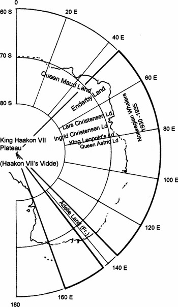
The second BANZARE sailed on Discovery from Hobart in November 1930 to complete the process of formally claiming territory from Oates Land (160°E) west to Mac.Robertson Land. New land was discovered from an aircraft on 9 February when at 66°29′S, 76°15′E (Mawson Reference Mawson1932). This was subsequently called Princess Elizabeth Land and like Mac.Robertson Land, was within the unspecified area between Kemp and Queen Mary Lands. Before Discovery reached this area, large sections of the coast had been sighted and named by Christensen's whalers who had been working in the region since 12 January 1931. Subsequent Christensen expeditions continued to map, name and claim sections of Antarctic between 60°E and 86°E until 1937 as shown on Fig. 3.
Eastern Antarctica showing the boundaries of Australian Antarctic Territory (heavy lines), the position of Enderby Land on Norwegian maps and the areas discovered and named by Norwegian whalers between 1929 and 1935.

The Norwegian prime minister, M. Mowinckel, in response to claims made by Captain Klarius Mikkelsen in February 1935 to the newly discovered Ingrid Christensen Land (which was within Princess Elizabeth Land) was that ‘annexation had not been considered by the Ministry of Foreign Affairs as the country was most probably in the British sector’ (GBFORD 1945: 107). Despite being under pressure from Norwegian whaling interests to annex Antarctic territory, the Norwegian Government did not recognise claims made by Christensen's whalers to territory, which by this time, had become AAT.
Following completion of the second stage of the Imperial Conference defined process, an Order in Council was issued on 7 February 1933 proposing that all the islands and territories, other than Adélie Land, which were situated south of 60°S between the 160°E and 45°E be placed under the authority of the Commonwealth of Australia (Order in Council 1933). The Australian Antarctic Territory Acceptance Bill was introduced into the federal parliament in May 1933. While much of the debate was on the value of whaling, the attorney-general, John Latham, introducing the bill, stated that the territory included the ‘eastern part of Queen Maud Land’ (Australian Antarctic Territory Acceptance Bill 1933). He also mentioned in relation to Mawson's BANZARE that ‘in January, 1930, the Norwegian, Captain Riiser-Larsen, in the Norvegia, visited, shortly after the Discovery, the area west of Enderby Land, and gave it the name of Queen Maud's Land’ (Australian Antarctic Territory Acceptance Bill 1933). This statement was interpreted by the Norwegians as stating that Mawson had discovered Queen Maud's Land before Riiser-Larsen. However the statement does not say this. It simply says that Riiser-Larsen named Queen Maud Land after the meeting with Mawson when Norvegia had sailed east towards Enderby Land. Discovery, earlier on the day of the visit, had sailed west from Enderby Land over the same area. The misinterpretation aroused angst in Norway (Aagaard Reference Aagaard1934). (Riiser-Larsen named Dronning (Queen) Maud Land after his flight on 15 January 1930.)Footnote 5
The act received royal assent on 13 June 1933 and came into operation in June 1938. A copy of the Order in Council was forwarded to the Norwegian government in February 1933.
Norway's response to AAT
The reaction of the Norwegian government to the Order in Council establishing the AAT was expressed in a memorandum to the British foreign office in February 1934 (Vogt Reference Vogt1934). The memorandum expressed the government's concern that nearly two thirds of the Antarctic continent and adjacent islands were under foreign control which might impose future restrictions on Norwegian whaling activities. The memorandum fell short of an outright objection over the inclusion of Haakon VII Vidde (polar plateau) in AAT and that ‘reservations may be made as they had been in respect of the Ross Dependency’ (Vogt Reference Vogt1934).
Concerns were also raised with respect to the western border of AAT being 45°E, as the territory then included a substantial part of Queen Maud Land that had been discovered and mapped by Norwegians. Christensen, although he had earlier advised Riiser-Larsen to refrain from occupying territory east of 45°E, argued that the border should be at 50°E as shown on some maps of the day (Christensen Reference Christensen1935: 220). As the geographical limits were not specified in the Imperial Conference summary for ‘the territories of interest’ they were open to further interpretation.
AAT boundary issues continued with Norwegian incursion into territory that Norway had not yet recognised as being Australian. This prompted a letter from the foreign office in November 1938 seeking recognition of these boundaries and expressing concern that Norwegian explorers were not recognising British sovereignty over the territory. The letter also detailed each of incursion incidents starting with Riiser-Larsen's flight on 22 December 1929 and ending with a flight and landing made by Lars Christensen in January 1937 (Mounsey Reference Mounsey1938). Concerns were also raised regarding the renaming by Mawson of areas discovered and named by Norwegian whalers east of Kemp Land in January 1931.
Norway finally recognised Australian sovereignty on 15 January 1939 by advising Britain that they recognised the boundaries of AAT (Colban Reference Colban1939). This was the day after a royal decree was issued establishing Norwegian Antarctic Territory. The territory was defined as lying between the limits of Australian Antarctic Territory in the east and the limits of the Falkland Islands Dependency (the boundary of Coats Land) in the west (Bush Reference Bush1982b; 149). Norway, in claiming the territory, did not specify southern or northern limits in accordance with their rejection of the sector principle. Britain had supported a Norwegian claim to this sector since early 1930 when the Norvegia commenced operations west of 45°E.
Conclusion
This paper has shown that the Norwegian whalers were incensed by British expansion in the Antarctic. This drove them to seek territory free of British control and to claim Bouvet Island for Norway. British territorial domination of the Antarctic, promoted by Amery led to the development of a process to claim AAT at the 1926 Imperial Conference. It has been shown that AAT was gained in accordance with this process; a process, that was in accordance with international law at the time. The role of BANZARE in this process did not halt the advance of Christensen's whalers who continued to claim territory in the unlisted area between Kemp Land and Queen Mary Land after the Order in Council established AAT.
Norwegian dependence on maintaining friendly relations with Britain is evident in their agreement not to claim territory listed by the Imperial Conference as of ‘special interest’ to Britain in return for title to Bouvet Island and in their rejection of territorial claims made by Riiser-Larsen and Mikkelsen. This, and the absence of an outright objection to the British claim for territory on behalf of Australia, suggests tacit Norwegian government support for the British claim. This support was reciprocated by the British government in recognising Norway's claim to territory between AAT and the FID.
Given the friendly relations between Norway and Britain was there a ‘battle fought for Britain and Australia’ as stated by Price? Based on the information given in this paper, there is little evidence to support even a metaphorical battle. Was Australian Antarctica ‘won’, or simply gained by the diligent execution of the process devised at the Imperial Conference in 1926? If ‘won’, when? Was it when Riiser-Larsen and Mawson agreed the boundary of operations should be 40°E (as reported by Mawson) or 45°E (as stated by Christensen), or was it when Norway failed to object outright to Australia's claim, or when Norway finally recognised the boundaries of AAT in 1939?
Acknowledgements
The author wishes to thank Tor Skjellaug for translating chapters of Bjarne Aagaard's Fangst of Forskning I Sydishavet into English, Julia Jabour for enthusiastic help, advice and corrections to the manuscript, my honours supervisors Marcus Haward and John Gibson for suggesting I write a paper based on my thesis research and finally, Andie Smithies and the staff of the Australian Antarctic Division library for their continued help.