


Introduction
Rates and mechanisms of lowering of moraines and debris-covered ice have been described from many glaciated areas of the world. Mechanisms proposed include ablation of the ice below the debris mantle (Reference ØstremØstrem, 1959, Reference Østrem1964), direct melting of exposed ice (Reference JohnsonJohnson, 1971), melting beneath lakes (Reference DriscollDriscoll, 1980), geothermal heating (Reference DriscollDriscoll, 1980), melting of ice by running water (Reference WatsonWatson, 1980), development of large cracks in the ice (Reference JohnsonJohnson, 1971), steps along shear planes (Reference JohnsonJohnson, 1971), mudflows of the silty unconsolidated moraine veneer (Reference JohnsonJohnson, 1971), development of kettle holes (Reference JohnsonJohnson, 1971), and combinations of two or more of these (Reference DriscollDriscoll, 1980). A new mechanism—wandering lakes—is described here and evidence is provided from Antarctica.
Lake wandering on Flanders Moraine
Three lakes (Fig. 1) on a stagnant ice-cored moraine, Flanders Moraine, in the south-east of the Vestfold Hills, Antarctica (lat. 68° 38’ S., long 78° 12’ E.), show lateral movement which has been measured for two lakes (Table I) and inferred for the third from nested arcs of lake-floor sediment (Fig. 1). The lakes occur in low points on the surface of the moraine, and as they wander across its surface, they inevitably consume higher ice. Wander occurs as a result of the rapid retreat of ice slopes on shores that are too steep to support a stable mantle of insulating till, and by the collapse of near-vertical ice cliffs after formation of thermo-erosional niches at water level. In Pelite and Crescent Lakes, movement is occurring on the side where the bank is steepest, leaving behind a gently sloping bank of lake-floor sediments. This implies that the lakes do not necessarily deepen as they wander.
Location maps of Vestfold Hills (a), Flanders Moraine (b), and Pelite Lake and Crystal Pond (c), showing descending arcuate ridges at Crescent Lake, and changes in the margins of Pelite Lake and Crystal Pond.

Crescent Lake has lowered its bed by at least 20 m during a lateral movement of c. 500 m. leaving behind descending arcuate steps of lacustrine sediment thick enough to insulate the underlying ice. Each tread probably represents a temporarily stable stage in the lake separated by rather sudden lowerings of water level. The water level in Pelite Lake fell suddenly by 4 m over 1 week in the austral summer 1980–81 when a low point in the lake margin was breached. However, sufficient water remained in the lake to ensure its continued lateral movement. Such events may also drain ice-based lakes completely; one small lake near Crystal Pond was drained completely between 1958 and 1979. Several lakes south-east of Pelite Lake drained completely between 1979 and 1981, probably when Pelite Lake partially drained. Localized elevated patches of lacustrine sediments on the surface of Flanders Moraine show the former presence of lakes and relief inversion as the well-insulated lake floors become elevated surfaces.
Rates of Lowering Due to Lake Wandering
Lakes with an area > 1 ha occupy a minimum of 14 ha or c. 7% of the 208 ha of Flanders Moraine. Adding the smaller lakes and innumerable ponds would probably raise the figure to c. 15–20%. If these lakes are as mobile as Pelite Lake and Crystal Pond, i.e. change by 50% in 20 years, then the entire surface of the moraine will be affected in c. 200 years. The average depth of the lakes is unknown but it is certainly more than 5 m and probably more than 10 m. Taking an average depth of 10 m, the entire moraine would be lowered by this amount in 200 years, i.e. c. 0.05 m year−1. If we include lowering due to other causes: creek melt, direct ablation below debris, etc., then the rate may well double.
Crude confirmation of these calculations comes from observed rates of scarp retreat on Flanders Moraine. Reference PickardPickard (in press) found total retreat of c. 2 m year−1 for Pelite Lake and Crystal Pond after 9 weeks monitoring at 35 sites. This is very similar to the 20-year rate determined from air photograph interpretation (Table I). Crescent Lake has moved c. 500 m and has lowered the surface 20 m in its path. At 2 m year−1, this lateral movement would take c. 250 years, which is consistent with the calculation above.
Changes in Pelite Lake and Crystal Pond, 1958–79, Determined Using Air Photographs

Flanders Moraine is probably a relict from the Chelnok Glaciation Reference Adamson and Pickard(Adamson and Pickard, in press), when ice surged northward from Sørsdal Glacier. Other evidence suggests that this occurred between 1 000 and 2 000 years ago. The ice covered the highest hills (160 m a.s.l.) in the south-eastern corner of the Vestfold Hills. Taking 200 m as the minimum altitude of the ice surface implies that c. 60 m has melted. At a linear rate of 0.05 m year−1, this gives a minimum age of 1 200 years for the Chelnok Glaciation. This is consistent with the age suggested by Reference Adamson and PickardAdamson and Pickard (in press).
Discussion
Over most of the area of Flanders Moraine, the ice is protected from rapid melting by 1–3 m of till which forms a substantial insulating layer. One of the important effects of lake wander is to disturb this insulating layer of till and to expose the underlying ice to direct insolation, to flowing melt water, and to lake water. The lakes are laterally mobile hot spots which locally accelerate melting of the stagnant ice as they wander across its surface. Comparison with results from elsewhere is difficult because of differences in climate and techniques used. Even so, the various rates are of the same order (Table II).
Rates of Surface Lowering of Clean and Debris-Covered Ice
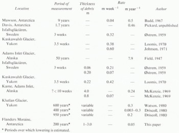
Reference DriscollDriscoll (1980) discussed surface lowering of moraines on Klutlan Glacier due to lakes but proposed deepening rather than wandering as a mechanism. Reference WatsonWatson (1980) described collapse of ice cliffs into lakes on the same moraines but also failed to mention wander as a mechanism. For 5 months each summer the mean daily temperature of Klutlan Glacier is above zero, and the mean minimum is above zero for 3 months Reference Driscoll(Driscoll, 1980). This is considerably warmer than Flanders Moraine Reference Burton and Campbell(Burton and Campbell, 1980); consequently the rate of lake wander on Klutlan Glacier would be more rapid. Possibly, shear zones in the ice of the Klutlan Glacier moraines would effectively prevent lakes wandering great distances as they would drain along the shear zones.
Surface lowering is usually the result of a combination of processes. Partition between these processes is not possible except in favourable circumstances. Reference DriscollDriscoll (1980) has attempted to quantify the component of lowering due to different processes but most studies do not. This is due partially to the difficult climates of such areas but also to very real problems of experimental design. On any one moraine, the dominant process probably changes over each melt season. It will also vary on a daily basis and due to weather changes. Under these conditions, accurate apportioning of contribution is well nigh impossible.
Where lakes exist on ice-cored moraines, they should be regarded as a potentially rapid mechanism for surface lowering. Lake wander is less susceptible to the vagaries of weather changes and can even proceed over winter.
Acknowledgements
I thank the Antarctic Division for financial and logistic support while I was a member of the 1978 and 1980 Australian National Antarctic Research Expeditions. Suggestions from an anonymous referee prompted substantial improvement to the paper.
MS. received 18 December 1981 and in revised form 22 July 1982



