INTRODUCTION
A major objective of the Chignik-Meshik Rivers Cultural Resource Reconnaissance project (Shirar et al. Reference Shirar, Rasic, Barton and Reid2011, Reference Shirar, Barton, Jordan and Rasic2012, Reference Shirar, Barton, Jordan and Rasic2013; Shirar et al. Reference Shirar, Barton and Jordanforthcoming) was to establish a chronology of human occupation of the central Alaska Peninsula. In other parts of the peninsula and throughout southwest Alaska researchers have used a variety of methods to estimate the age of archaeological deposits, including radiocarbon (14C) dating (e.g. Crowell and Mann Reference Crowell and Mann1996), tephrochronology (e.g. Dumond Reference Dumond2011), and identification of artifacts and/or architectural features belonging to temporally constrained cultural horizons (e.g. Steffian and Saltonstall Reference Steffian and Saltonstall2004). However, because so little is known about the prehistoric cultural identities of the people of the central peninsula, and because the sequence, absolute age, and spatial distribution of tephra deposits have not been established, this project instead focused on radiometric age estimation of organic materials recovered from secure cultural and geological contexts. In addition to mapping out a framework of where and when people lived throughout the region, our goal with this chronological sampling was to improve our understanding of landscape change (both geomorphic and ecological) in response to volcanic activity.
This project produced 92 accelerator mass spectrometry (AMS) 14C age determinations, sampled from a large array of field specimens (>350). Of these, 75 were taken from cultural contexts (including house floors, hearths, and other buried features) at 31 unique human settlements. An additional 17 come from non-cultural geomorphic contexts (including stratified bluff faces, river cuts, and peat and estuarine deposits) in five unique depositional settings, and will be described elsewhere. Here we describe the sampling, preparation, and measurement methods used in this project, illustrate patterns of human settlement across the central Alaska Peninsula during the Holocene, and provide preliminary insights about the effects of volcanism on ecological succession and human occupation.
Sample Selection
Sub-surface testing of presumed cultural deposits was designed to accomplish four primary goals: (1) to confirm that features visible on the surface were indeed cultural, (2) to evaluate the depth and superposition of different occupations, (3) to establish the age of these occupations, and (4) to assess the cultural affinities of these occupations. When secure cultural deposits (i.e. stratified, undisturbed, charcoal and artifact rich strata, often separated by tephra deposits and/or house floors and roofs) were encountered, excavators collected large pieces of in-situ charcoal from test unit plans and profiles, but not from the sediment sieves. Selection of samples for AMS 14C dating focused on those from secure cultural components with taxonomic identification. Every effort was made to connect the uppermost cultural component with the architectural feature visible on the surface, thereby capturing the age of the feature type (e.g. single- and multi-room features of various configurations). When test units revealed more than one cultural component (usually separated by deposits of tephra), we sampled both for radiometric dating. Because much of our sub-surface testing revealed multiple cultural components, we elected to provide ages for as many as possible rather than to attempt discrimination of each component from deposits visible only in 50×50-cm test units. More expansive excavations of individual architectural features along with more extensive excavations from each site would surely produce a more detailed, and more tightly constrained chronology for each settlement. Likewise, more thorough excavations might reveal patterns of foundation building, structural refurbishing, and rebuilding that simply are not possible to untangle in small test units. However, our goal with this sampling design was to collect evidence for human occupation over a broad area, and across many millennia. AMS dating of cultural charcoals from multiple test units makes this possible.
Sample Identification
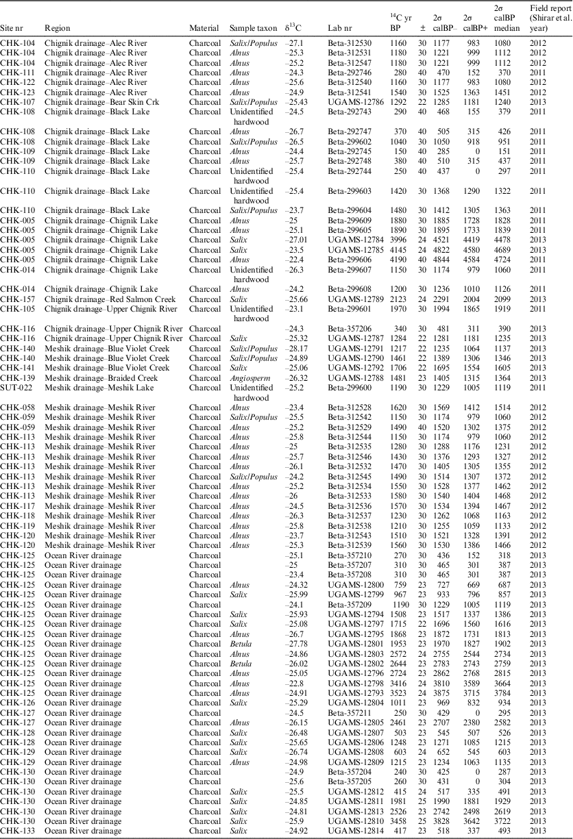
Due to the chemistry of volcanic soils that mantle much of the Alaska Peninsula (Ping et al. Reference Ping, Shoji and Ito1988), organic materials (including bone) in most contexts do not preserve for more than a few centuries. Therefore, inert carbon from burned wood is the most common material available for 14C dating, and the taxonomic identity of each piece of carbonized wood is critical for estimating the age of human activity. The central peninsula is essentially treeless, with woody vegetation consisting of low-lying alder (Alnus spp.), willow (Salix spp.), poplar (Populus spp.), and shrub birch (Betula spp.). Prehistoric inhabitants would have also had access to large pieces of driftwood on both the Pacific and the Bering Sea Coasts. Because the coast was never more than 30 km away, driftwood from large, exotic trees was surely incorporated into the building materials, tools, and fuels of the prehistoric inhabitants. To avoid this “old-wood” problem (Schiffer Reference Schiffer1986), which is potentially exacerbated when large old trees circulate around the North Pacific, we focused our charcoal sampling on locally abundant, short-lived taxa (namely Salix spp., Populus spp., Alnus spp., and Betula spp.). When such taxonomic resolution was not possible, we also considered sampling unidentifiable hardwoods. Softwoods, and conifers of all kinds (including spruce, which is abundant on the northern peninsula, only 300 km away) were avoided. A single piece of unidentified charcoal, associated with several samples of softwood charcoal, was chosen for AMS (Beta-357204). Certainly willows, alders, poplar, and birch can occasionally live to great age, can float around in oceanic gyres, and can be preserved in some surface settings, but carbonized wood specimens from these taxa are likely only a few decades older than when their wood was used by humans. Large conifers on the other hand may be centuries older, and well outside the variance imposed by instrumental error in AMS measurement and the variance in the calibration curve. In only a few cases did we select cultural charcoal samples without taxonomic identification (see Table 1); these age estimates should be viewed with some caution, even though charcoal from coniferous, or otherwise exotic trees is rare.Footnote 1
14C age determinations from cultural contexts. Calibrated with OxCal 4.2 (Bronk Ramsey Reference Bronk Ramsey2009) using the IntCal13 calibration curve (Reimer et al. Reference Reimer, Bard, Bayliss, Beck, Blackwell, Bronk Ramsey, Buck, Cheng, Edwards, Friedrich, Grootes, Guilderson, Haflidason, Hajdas, Hatté, Heaton, Hoffmann, Hogg, Hughen, Kaiser, Kromer, Manning, Niu, Reimer, Richards, Scott, Southon, Staff, Turney and van der Plicht2013). The 2σ upper and lower range and median reflect the 95.4% probability output from OxCal. Context and provenience of each can be found in print (Shirar et al. Reference Shirar, Rasic, Barton and Reid2011, Reference Shirar, Barton, Jordan and Rasic2012, Reference Shirar, Barton, Jordan and Rasic2013; Shirar et al. forthcoming) and in the online dataset (Barton et al. Reference Barton, Shirar and Jordan2017).

Pretreatment, Measurement, and Calibration
All selected samples were sent to one of two labs over the course of three years for pretreatment, graphitization, and AMS measurement: Beta Analytic, Inc. (lab code Beta-) processed 54 samples; the Center for Applied Isotope Studies at the University of Georgia (lab code UGAMS-) processed another 38.Footnote 2
Both labs pre-process carbonized wood samples with a standard acid-alkali-acid (HCl-NaOH-HCl) wash sequence before drying, combustion, and graphitization (following methods described in Hedges et al. Reference Hedges, Law, Bronk Ramsey and Housley1989 and Vogel et al. Reference Vogel, Southon, Nelson and Brown1984, respectively).
Both labs measure graphite 14C/13C ratios using an accelerator mass spectrometer and correct by comparison to measurement of a known reference standard (Oxalic Acid; see lab reports for specifics). Age estimates are calculated using the Libby 14C half-life (5568 yr), and corrected for isotopic fractionation using an independent measurement of 13C/12C, calculated relative to the PDB standard. Corrected lab results are presented in 14C years before present (14C yr BP), conventionally before AD 1950.
General Observations
All age estimates generated by this project are sufficiently precise to meet contemporary objectives for good 14C “hygiene” (see Kennett et al. Reference Kennett, Stafford and Southon2008; Spriggs Reference Spriggs1989). Measurement error across all cultural samples was tight, no samples with marine reservoir effects were used (no marine or aquatic taxa were sampled, and the 13C/12C of all samples fall squarely in the range of terrestrial C3 plants), and we made every effort to eliminate the “old-wood” problem by sampling charcoal from local, short-lived hard-wood taxa. Although nine samples were not identified taxonomically, it is unlikely that any come from exotic old wood because charcoal from such wood was exceedingly rare in the total identified assemblage, and none of the results fall outside of expectation given their archaeological context.
Analytical Framework
To evaluate spatial and temporal patterns of human land-use in relation to volcanic activity and landscape change, we combine calibrated 14C probability distributions (referenced here as summed probability distributions, or SPDs) from multiple samples taken from similar contexts. Combining 14C age estimates in this way serves two useful purposes: (1) it provides a graphical illustration of the probability that some spatially explicit analytical unit (a house, a settlement, or a region) was active at any given time; and (2) it enables both graphical and quantitative comparisons among different analytical units. In cultural terms, we can evaluate the contemporaneity of different houses, the cycles of occupation and abandonment in a single settlement, or broad patterns of human activity in different river drainages.
Over the past 30 years, use of aggregated 14C age estimates (both calibrated and uncalibrated) has become more sophisticated and more creative, in both method and application (Weninger Reference Weninger1986; Rick Reference Rick1987; van Andel et al. Reference van Andel, Davies, Weninger and Jöris2003; Gamble et al. Reference Gamble, Davies, Pettitt and Richards2004; Barton et al. Reference Barton, Brantingham and Ji2007; Brown Reference Brown2017; Hutchinson and Crowell Reference Hutchinson and Crowell2007; Shennan and Edinborough Reference Shennan and Edinborough2007; Kelly et al. Reference Kelly, Surovell, Shuman and Smith2013). Increasingly analysts have come up with different ways to improve the precision for each date (e.g. Bayliss Reference Bayliss2009; Kennett et al. Reference Kennett, Culleton, Dexter, Mensing and Thomas2014) and new ways of aggregating and analyzing multiple calibrated dates (e.g. Brown Reference Brown2015; Woodbridge et al. Reference Woodbridge, Fyfe, Roberts, Downey, Edinborough and Shennan2014). Yet there are still concerns about the robustness of the resulting SPD, and therefore concerns about the utility of it for investigating population patterns, particularly relative and absolute demographic dimensions (Michczynski and Michczynska Reference Michczynski and Michczynska2006; Surovell and Brantingham Reference Surovell and Brantingham2007; Buchanan et al. Reference Buchanan, Collard and Edinborough2008; Culleton Reference Culleton2008; Surovell et al. Reference Surovell, Finley, Smith, Brantingham and Kelly2009; Collard et al. Reference Collard, Edinborough, Shennan and Thomas2010; Bamforth and Grund Reference Bamforth and Grund2012; Williams Reference Williams2012; Shennan Reference Shennan2013; Contreras and Meadows Reference Contreras and Meadows2014; Drennan et al. Reference Drennan, Berrey and Peterson2015).
While the concerns surrounding these debates are well placed, and continued discussion will surely improve the accuracy, precision, and strength of our analytical tools, even in its infancy the SPD is a useful depiction of the likelihood of human activity in the past. For the purpose of this project, which looks at patterns across ~5,000 years over a large geographic area, we are comfortable with the basic level of imprecision associated with calibrated SPDs. Modeled approaches to reducing the calibrated variance by relying on priors such as stratigraphic relationships, blankets of volcanic tephra, or tightly seriated artifact chronologies are unlikely to improve the results of the current study. We simply do not know enough about the cultural or volcanic sequences to warrant this, though anticipate that the results of this project will make future efforts possible. Furthermore, we do not use the SPD as a robust demographic estimator in this study, but rather as a useful graphical depiction of occupation periods in the region. The intent here is to provide a preliminary periodization, and to offer preliminary comparisons.
All graphical SPDs in this report were produced using the CalPal software package (Weninger et al. Reference Weninger, Jöris and Danzeglocke2007) using the IntCal13 calibration curve (Reimer et al. Reference Reimer, Bard, Bayliss, Beck, Blackwell, Bronk Ramsey, Buck, Cheng, Edwards, Friedrich, Grootes, Guilderson, Haflidason, Hajdas, Hatté, Heaton, Hoffmann, Hogg, Hughen, Kaiser, Kromer, Manning, Niu, Reimer, Richards, Scott, Southon, Staff, Turney and van der Plicht2013). Note that there will be minor differences between the calibrated age ranges produced by CalPal and those produced by OxCal, the latter of which are presented in Table 1.
Analytical Units
On the most basic level, our primary goal with this project was to figure out when different places were occupied in relation to the timing of volcanically induced landscape change. We also wanted to know when distinct settlements were occupied and abandoned, and how these patterns might reveal something about how people (and different behaviors, subsistence strategies, and technologies) moved about the landscape. Finally, we hoped to learn something about the timing and distribution of diagnostic cultural attributes known to discrete times and places outside the study region with the hopes of drawing some connection to larger, super-regional population-level processes. This final objective proves the most difficult because our sampling strategy produced so few diagnostic elements (namely artifacts). The only truly ubiquitous diagnostic cultural effects we have are architectural features visible immediately underneath the surface (see Shirar et al. forthcoming). Here we confine our efforts to evaluating broader patterns of occupation, both inside and outside of the study area.
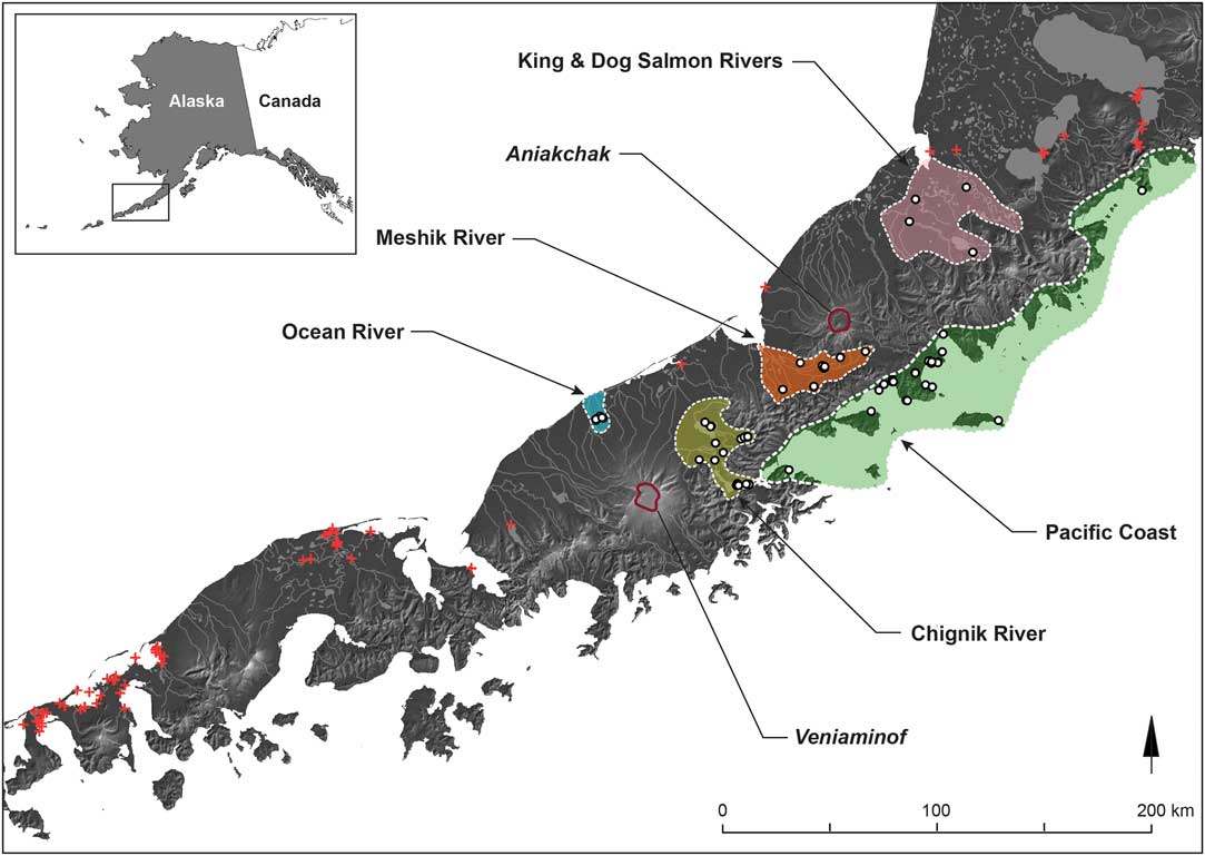
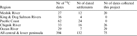
Our survey design targeted a variety of different land-forms and drainages throughout the study area for the purpose of understanding how volcanic activity might have affected biotic productivity (and as a result, human activity) in different settings. For a coarse-grained analysis of 14C data we divide the study area into three analytical units based on contemporary watersheds: the Meshik, Chignik, and Ocean River drainages (see Figures 1 and 2). 14C data are summarized for these units, which include all data collected during this project and all previously recorded 14C data, as reported in both the literature and the Alaska Heritage Resources Survey (AHRS) database.Footnote 3 Though all of the 14C data collected for the current project are reasonably precise, the same cannot be said of all previously reported age estimates, some of which were measured decades ago. Regardless of precision, all available age estimates were calibrated and added to the SPDs for each analytical unit. For the Meshik, Chignik, and Ocean River drainages, most (or all) of the 14C data come from this project; we include previously reported data to ensure that we did not miss important periods of human occupation not captured in our survey (see Table 2).
Analytical units of the central Alaska Peninsula. White circles depict locations of 14C dates included in distinct areas; red crosses depict locations with 14C dates from elsewhere in the central and lower peninsula.

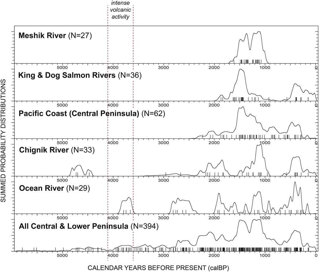
Summed probability distributions of calibrated 14C dates from different analytical units, both inside and outside of the study area, corresponding to those illustrated in Figure 1. Produced using the CalPal software package (see text for justification).

14C age determinations by analytical region. All data and data sources included in this analysis are available online. Note: the category “All central & lower peninsula” represents all cultural dates from this project plus another 319 previously reported 14C dates from archaeological sites both inside and outside the 5 analysis areas. Sites outside appear as crosses in Figure 1.

Analytical units from inside the study area are then compared to analytical units outside of, but adjacent to, our study area, namely the King Salmon and Dog Salmon River drainages, and the Pacific Coast. Comparison of these five discreet spatial units enables a comparison of the timing of human activity in different areas, and enables us to visualize patterns of occupation, abandonment, and re-occupation, and ultimately an assessment of how these patterns match up with chronological evidence for volcanism and landscape change (see Shirar et al. forthcoming). These five analytical units are then compared to a compilation of 14C data (including our own) from the broader region of the central and lower Alaska Peninsula (roughly from the southern end of Becharof Lake in the northeast to False Pass in the southwest). While this broad, regional compilation may not include all existing 14C data, the sample is sufficiently large to illustrate general patterns of activity throughout the region during the middle and late Holocene.
RESULTS
Summed probability distributions of calibrated 14C dates for each analytical unit are presented in Figure 2 to reveal general patterns of occupation. The time frames of known volcanic events (namely, the catastrophic mid-Holocene eruptions of Veniaminof and Aniakchak) are also provided graphically in Figure 2 to enable comparison. Note that the age estimates for these eruptions vary widely, and are the subject of considerable debate (Miller and Smith Reference Miller and Smith1987; Beget et al. Reference Beget, Mason and Anderson1992; Pearce et al. Reference Pearce, Westgate, Preece, Eastwood and Perkins2004; VanderHoek Reference VanderHoek2009; Blackford et al. Reference Blackford, Payne, Heggen, de la Riva Caballero and van der Plicht2014; Davies et al. Reference Davies, Jensen, Froese and Wallace2016); we use them here with caution.
The compilation of all dates from the central and lower Alaska Peninsula suggests that the region was first occupied just prior to 5100 cal BP. There is little evidence for human occupation of the region for the next 1000 years; whether this is because there were few people in the region, or because settlements during this interval have evaded archaeological detection, cannot be addressed with the current data. However, the absence of occupation evidence from ca. 4150–3950 cal BP may reveal the devastating impact of the caldera-forming eruption of Veniaminof, estimated as occurring between ca. 4100–3900 cal BP (Miller and Smith Reference Miller and Smith1987), but this must remain speculative. What we can say is that some parts of the peninsula were occupied from ca. 4000 cal BP to the present day, this in spite of the purported impact of the Aniakchak II eruption of ~3700 cal BPFootnote 4 . This alone does not evaluate the full effects of the Aniakchak II eruption on human habitation, cultural and/or linguistic diversity, or landscape change: it merely notes that people continued to live somewhere in the region, in spite of those effects. We can see that the abundance of evidence for human occupation (in the form of 14C dates) increases after 2500 cal BP, and peaks from about 1500–900 cal BP. A more robust sampling of these cultural and geological contexts would be necessary to interpret the peaks and troughs of this SPD as a demographic proxy.
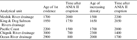
A number of important points (both certain and speculative) can be made from observations of the discreet analytical units in varying proximity to the volcanoes of the region. First, though our survey was designed to identify the nature and distribution of human activity prior to the major mid-Holocene eruptions, we encountered this in only one place: the mouth of Chignik Lake (specifically, at CHK-005). The SPD for the entire Chignik River drainage also suggests that the mid-Holocene eruptions had a significant effect on human activity, as there is no evidence for it from ca. 4400–3100 cal BP. Assuming the date for the Aniakchak II eruption is correct (ca. 3700 cal BP) it took another 700 years for people to occupy the region at a detectable intensity. However, it was not for another 1400 years (by 2300 cal BP) that the Chignik drainage saw an increase in the abundance and distribution of settlements (see Table 3).
A comparison of the age of first evidence for human activity in each analytical area, and the age when the density of 14C data increases markedly for each area, along with the amount of time elapsed for each since the caldera-forming eruption of the Aniakchak volcano (ANIA II eruption).

The SPD from the Ocean River drainage (centered on settlements around Wildman Lake) tells another part of the story. First, in spite of the fact that this small region is immediately north and downslope of the Veniaminof volcano, people lived there soon after its major caldera-forming eruption (ca. 3900–3800 cal BP). If the combination of dates for this eruption can be taken at face value (ca. 4000 cal BP)Footnote 5 , this means that the region was habitable within 200 years. Whether this means that the effects of the eruption were minimal on the north slope of the volcano, or because this short river drainage and coastline were quick to recover from them are open questions. We do, however note that the area was not occupied from ca. 3600–2900 cal BP and suggest this likely reflects the disturbance associated with the Aniakchak II eruption of 3700 BP. If so, it would suggest that people avoided the region for 800 years after the eruption, which was a little more than 100 km away. That people were living at both Wildman Lake and the lower end of Chignik Lake at approximately the same time (within ~150 yr of each other) may point to cultural, or at least adaptive, similarities among people that re-colonized the area. This issue is quite testable as the settlements in both areas are stratified, reasonably well-preserved, and rich in material remains (compare CHK-125 at Wildman Lake and CHK-031 at Chignik Lake).
Archaeological evidence from the Pacific Coast also informs the relationship between volcanic succession and human occupation. Though we recorded settlements along the Pacific Coast, we did not study them on the ground. The bulk of the work in this area was conducted in the process of a cultural resource survey of the Aniakchak National Monument and Preserve (VanderHoek and Myron Reference VanderHoek and Myron2004). Perhaps the most interesting observation of the Pacific coastal data is that there is no evidence for human activity prior to ca. 2200 cal BP. We find it unlikely that nobody occupied these resource-rich, and often sheltered marine habitats, particularly since we have ample evidence for marine-adapted coastal foragers in the eastern Aleutians by 9000 cal BP (Knecht and Davis Reference Knecht and Davis2001; Rogers et al. Reference Rogers, Yarborough and Pendleton2009), by at least 5000 cal BP on the Bering Sea side of the peninsula (Maschner Reference Maschner1999; Maschner Reference Maschner2004a, Reference Maschner2004b), and by 7700 cal BP on the Pacific side only 300 km farther up the peninsula (Schaaf Reference Schaaf2008; Tennessen Reference Tennessen2009).
More likely is that the earliest parts of the Pacific sequence have escaped detection because site locations have been obscured through the combined effects of isostatic, eustatic, and tectonic influence on relative sea level (Jordan and Maschner Reference Jordan and Maschner2000; Jordan Reference Jordan2001): we may simply be looking in the wrong places. However, we also find it unlikely that the entire record prior to 2200 cal BP, or our ability to detect that record, was affected by sea level change in exactly the same way. One expects the pre- and early post-volcanism records found at Chignik and Wildman Lakes to appear on the Pacific coast as well. However, there is no evidence for human activity on the coast until ca. 2200 cal BP. Though it is tempting to use these data to suggest that coastal and nearshore resources were insufficient to support human occupation for another 1500 years after the Aniakchak II eruption, this seems unlikely. If anything, one expects marine habitats to rebound much more rapidly than the terrestrial, riverine, and lacustrine habitats, which should be disproportionately impacted by volcanic deposition and chemical alteration. This assumption may be incorrect. More focused research on the Pacific coast of the central Alaska Peninsula should help to resolve these issues.
As with most of these analytical areas, the evidence from the King Salmon and Dog Salmon Rivers (which both join the Ugashik River at the head of Ugashik Bay) does not reveal anything about human habitation prior to the volcanism of the mid-Holocene. In part this may reflect the difficulty of finding the material remains of small numbers of mobile hunter-gatherers underneath the constantly accreting volcanic sediments, but it also might simply be that big portions of this vast coastal plain were submerged under higher sea-levels or simply so water-logged that they were uninhabitable. However, we do not expect sea level in this area to vary in the same way that it did farther south (cf. Jordan Reference Jordan2001), as the oldest evidence for human occupation at Ugashik Narrows (Henn Reference Henn1978), which is ~50 km northeast of the outlet of the King and Dog Salmon Rivers and today’s coastline, comes from a landform only ~10 m above contemporary sea level; ca. 10,100 cal BP, relative sea level might have been nearly 10 m higher than it is today in the area, but there is no geomorphic evidence that it has been higher than that since. Though the geohydrology of these rivers during the early Holocene was almost certainly different than today, (which might explain why no early Holocene human evidence has been found) we do see that people only started to settle the banks of the rivers after 1950 cal BP, some 1750 years after the Aniakchak II eruption. We suggest this delay was directly related to the timing of ecological recovery in Bering Sea river systems in the aftermath of the Aniakchak II eruption.
The Meshik River drainage is the closest to the Aniakchak volcano, and likely subjected to the most intense ecological disturbance of all the regions evaluated here. Accordingly, the Meshik River drainage was the last to be inhabited after the 3700 cal BP eruption. Indeed, we have no evidence for human activity prior to 1700 cal BP, some 2000 years after the eruption!
It is tempting to attribute the settlement of some of these zones (namely, the rivers of the Meshik, King Salmon, and Dog Salmon drainages) to something other than volcanic disturbance. For example, the earliest evidence of activity in these areas coincides broadly with the expansion of a riverine fishing adaptation, and perhaps demographic expansion often associated with the Norton cultural tradition, which became widespread across the upper peninsula by at least 2200 cal BP (Dumond Reference Dumond1981, Reference Dumond2011; Bundy Reference Bundy2007). Certainly the number of settlements dating from 2000–1000 cal BP seems to spike along the rivers of the central peninsula (as they do in the upper peninsula), and many, if not most of these appear oriented towards riverine resources (likely salmon, given the abundance of net weights and storage features), but it is also important to note that this spike is also visible on the Pacific Coast, which may not be connected with the Norton tradition at all. Furthermore, there is ample evidence for human activity prior to the interval of Norton expansion, in both the lower and upper parts of the peninsula (Maschner Reference Maschner2004b; Dumond Reference Dumond2011), as well as at Chignik and Wildman Lakes (both within the central peninsula study area), and perhaps along the Pacific Coast. The SPD for all dates from the central and lower (see the bottom frame of Figure 2) illustrates that frontier colonists were already in the area. The point is that had these river systems recovered sufficiently to support large aggregations of people, they should have been occupied much earlier. We suggest the delay is a result of the devastating effects of the Aniakchak II eruption and the time these ecosystems required to recover fully from them.
A number of other interesting patterns are visible in this comparison of SPDs. First, the abundance of evidence for human occupation of the Chignik, King Salmon, Dog Salmon, and Meshik Rivers declines considerably (in many cases to zero) ca. 1000 cal BP. This may well be associated with the effects of an as-yet unidentified volcanic disturbance. One possibility is the somewhat poorly documented Aniakchak eruption of 900 14C yr BP or the 1000 14C yr BP eruption of Veniaminof (Neal et al. Reference Neal, McGimsey, Miller, Riehle and Waythomas2001; VanderHoek Reference VanderHoek2009)Footnote 6 . Along the King and Dog Salmon Rivers, this gap in the record lasts about 500 years; in the Chignik River drainage it lasts at least 300 years; and in the Meshik drainage this marks the end of human activity until the historic, Euroamerican period (which we did not attempt to date with 14C).
Pulses in 14C dates beginning after 500 cal BP seem to document re-colonization of the King Salmon and Dog Salmon Rivers, the Chignik River drainage, and the Wildman Lake–Ocean River district. Less pronounced clusters are also visible on the Pacific Coast. What unites each of these pulses in each of the different analysis areas is the appearance of multi-room houses (Hoffman and Smith Reference Hoffman and Smith2007; Hoffman Reference Hoffman2009a, Reference Hoffman2009b; Saltonstall and Steffian Reference Saltonstall and Steffian2009; Shirar et al. Reference Shirar, Rasic, Barton and Reid2011, Reference Shirar, Barton, Jordan and Rasic2013 Reference Shirar, Rasic, Barton and Reid2011), perhaps documenting the spread of the Koniag architectural tradition (and perhaps colonists) from the Kodiak Archipelago (Barton et al. Reference Barton, Shirar, Chisholm, Rasic and Jordan2011).
CONCLUSION
This paper presents the results of one of the primary purposes of the Chignik-Meshik Rivers Region Cultural Resource Reconnaissance Project: to document where and specifically when people occupied different parts of the central Alaska Peninsula in the context of cultural and environmental change. Neither our sampling strategy nor our sample size permit quantitative assessments of the density or intensity of human activity in each area, nor do the summed probability distributions of 14C data permit realistic demographic estimates. But the data do reveal differences in the timing of human activity in different ecological settings, each in varying proximity to the two volcanoes known to have erupted catastrophically during the middle to late Holocene.
This effort builds on an emerging, but still nascent body of work in the region (Yesner Reference Yesner1981; Dumond Reference Dumond1987, Reference Dumond1992; VanderHoek and Myron Reference VanderHoek and Myron2004) that attempts to understand the relationships between volcanic activity, landscape change, ecological succession, and human occupation.
Certainly for some periods of time, the central peninsula was an “ecological frontier” (Yesner Reference Yesner1985) but at other times the region boasted sufficient resources to support large village-level aggregations along all of its rivers, lakes, and coastal ecosystems. Ultimately, the data presented here will help us to evaluate the reasons why some areas remained uninhabited for centuries to millennia, while others recovered sufficiently to permit human occupation. Furthermore, these data (and the material remains collected during this and other research projects) will reveal the cultural (namely technological and social) adaptations that made it possible for some groups to thrive in some areas but not others, or why some groups were more able to manage this difficult landscape more effectively than others. Ultimately we expect these elements will help inform our understanding of the nature of cultural affinities that attended the various waves of environmental disturbance, and the contraction and expansion, aggregation and dispersal, abandonment and re-colonization of the central Alaska Peninsula.
ACKNOWLEDGMENTS
This research was supported by the National Park Service through Cooperative Ecosystem Studies Unit task agreements with the University of Alaska Museum of the North (#J9796100057) and Antioch University New England (#P11AC60559). Special thanks to Jeanne Schaaf, Dale Vinson, Jeff Rasic, and Lois Dalle-Molle of NPS for institutional support; to Fawn Carter, Devon Reid, Sam Coffman, Jillian Richie, Linda Chisholm, Stormy Fields, and Lori Hansen for help in the field; and to the people of Chignik Lake, Chignik Lagoon, and Port Heiden for entrusting us with their cultural heritage. We hope this research will enable future scholarship and stewardship.