Introduction
Within the South Caucasus (equivalent of “Transcaucasia”), previous pollen studies have already been undertaken (Margalitadze, Reference Margalitadze1971, Reference Margalitadze1977, Reference Margalitadze1995; Kvavadze and Connor, Reference Kvavadze and Connor2005; de Klerk et al., Reference de Klerk, Haberl, Kaffke, Krebs, Matchutadze, Minke, Schulz and Joosten2009; Connor, Reference Connor2011; Messager et al., Reference Messager, Belmecheri, von Grafenstein, Nomade, Ollivier, Voinchet and Puaud2013; Joannin et al., Reference Joannin, Ali, Ollivier, Roiron, Peyron, Chevaux, Nahapetyan, Tozalakyan, Karakhanyan and Chataigner2014; Leroyer et al., Reference Leroyer, Joannin, Aoustin, Ali, Peyron, Ollivier, Tozalakyan, Karakhanyan and Jude2016). These studies have delivered quite different vegetation histories. The timing of postglacial forest expansion appears to vary between sites and is quite different from the pattern observed in western Eurasia. In fact, the major warming occurring at the transition between the Younger Dryas and the early Holocene (Reference Von Grafenstein, Erlenkeuser, Brauer, Jouzel and JohnsenVon Grafenstein et al., Reference Von Grafenstein, Erlenkeuser, Brauer, Jouzel and Johnsen1999; Rasmussen et al., Reference Rasmussen, Andersen, Svensson, Steffensen, Vinther, Clausen and Siggaard-Andersen2006; Svensson et al., Reference Svensson, Andersen, Bigler, Clausen, Dahl-Jensen, Davies and Johnsen2006), marked in western Eurasia by the expansion of temperate trees (Huntley and Birks, Reference Huntley and Birks1983; Wick, Reference Wick2000), is still associated with a steppic environment in several records from the South Caucasus (Margalitadze, Reference Margalitadze1995; Messager et al., Reference Messager, Belmecheri, von Grafenstein, Nomade, Ollivier, Voinchet and Puaud2013; Joannin et al., Reference Joannin, Ali, Ollivier, Roiron, Peyron, Chevaux, Nahapetyan, Tozalakyan, Karakhanyan and Chataigner2014; Leroyer et al., Reference Leroyer, Joannin, Aoustin, Ali, Peyron, Ollivier, Tozalakyan, Karakhanyan and Jude2016). Sites located in the eastern part of the region record later forest expansion than sites located in the western part (i.e., on the shore of the Black Sea; Kvavadze and Connor, Reference Kvavadze and Connor2005). Among the records from the eastern region, the pollen sequence from Lake Paravani (central South Caucasus, Javakheti Plateau) has revealed a delayed forest expansion, starting between 9000 and 8000 cal yr BP, almost 3 millennia after the onset of Holocene warming (Messager et al., Reference Messager, Belmecheri, von Grafenstein, Nomade, Ollivier, Voinchet and Puaud2013). Depending on the sequence in the region, the major postglacial ecological shift becomes evident only 2 to 5 millennia after the transition between the Younger Dryas and the early Holocene (ca. 11,650 cal yr BP).
Some authors suggest that the delay between the Younger Dryas–Holocene warming and forest expansion may be explained by a period of aridity (Stefanova and Ammann, Reference Stefanova and Ammann2003; Wick et al., Reference Wick, Lemcke and Sturm2003; Wright et al., Reference Wright, Ammann, Stefanova, Atanassova, Margalitadze, Wick and Blyakharchuk2003; Shumilovskikh et al., Reference Shumilovskikh, Tarasov, Arz, Fleitmann, Marret, Nowaczyk, Plessen, Schlütz and Behling2012; Connor et al., Reference Connor, Ross, Sobotkova, Herries, Mooney, Longford and Iliev2013). However, geochemical and isotopic indicators from several lakes in Turkey suggest increasing annual precipitation during the early Holocene (Lemcke and Sturm, Reference Lemcke and Sturm1997; Roberts et al., Reference Roberts, Reed, Leng, Kuzucuoğlu, Fontugne, Bertaux and Woldring2001; Wick et al., Reference Wick, Lemcke and Sturm2003; Jones et al., Reference Jones, Roberts and Leng2007; Dean et al., Reference Dean, Jones, Leng, Noble, Metcalfe, Sloane, Sahy, Eastwood and Roberts2015). The reasons for these differences among sites and regions are still unclear. In order to obtain a more comprehensive overview of the vegetation dynamics during the Younger Dryas–Holocene transition in the South Caucasus, new sedimentary sequences (Nariani, Saghamo, Kartsakhi, and Tabatskuri) have been cored on the Javakheti Plateau (southern Georgia). This article presents the initial results from this new coring program, consisting of a 180 cm sequence from the Nariani wetland. A previous pollen analysis was carried out in this wetland by Margalitadze (Reference Margalitadze1977) on an undated sequence of 7.75 m.
Regional and local setting
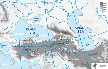
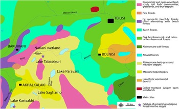
The Nariani wetland (41°41'N, 43°40'E; 2058 meters above sea level [m asl]) corresponds to a completely filled paleolake (area of ~10 km2) that evolved as extensive marshland (Fig. 1). The wetland lies adjacent to the Ktsia River and is located close to Lake Tabatskuri (Fig. 2) on the Javakheti Plateau. This plateau, located in the central part of the South Caucasus, is composed of basaltic-andesitic lavas that erupted during the Late Pliocene to late Pleistocene (Lebedev et al., Reference Lebedev, Bubnov, Dudauri and Vashakidze2008; Nomade et al., Reference Nomade, Scao, Guillou, Messager, Mgeladze, Voinchet and Renne2016). The Javakheti region possesses the largest number of lakes and marshes within the Caucasus (Matcharashvili et al., Reference Matcharashvili, Arabuli, Darchiashvili and Gorgadze2004). Inherited glacial morphologies and formations occur on the Javakheti Plateau, but today there are no glaciers present. The climate of the Javakheti Plateau is continental with long, cold winters and short, cool summers. The mean annual temperature is approximately 5.3°C, and the annual precipitation rate is about 500–600 mm with a maximum in late spring and early summer and a minimum in January (Matcharashvili et al., Reference Matcharashvili, Arabuli, Darchiashvili and Gorgadze2004). Today, the Javakheti Plateau is covered by herbaceous vegetation (Fig. 2) and surrounded by various types of forest (Nakhutrishvili, Reference Nakhutsrishvili1999). The most widely distributed vegetation community is mountain steppe, dominated by grasses (Poaceae family, e.g., Festuca spp. or Stipa spp.). Forest communities are mostly absent from the plateau, and only two small areas of subalpine forest still exist: a patch of Betula litwinowii, Populus tremula, and Sorbus aucuparia, located on the eastern part of Lake Kartsakhi (Matcharashvili et al., Reference Matcharashvili, Arabuli, Darchiashvili and Gorgadze2004); and a patch of dwarf beech forest located on the side of Mt. Tavkvetili (Arabuli et al., Reference Arabuli, Kvavadze, Kikodze, Connor, Kvavadze, Bagaturia, Murvanisze and Arabuli2008). Although the Javakheti Plateau is steppic, the Bakuriani region, located only 20 km northwest of the Nariani wetland (Fig. 2), is covered by different types of mountain forest. These forests are composed of beech (Fagus orientalis)-spruce (Picea orientalis) and fir (Abies nordmanniana)-spruce formations. Open woodland (called Krummholz), characterized by a mix of tall grassland, forbs, scrubs, and trees such as birch (Betula litwinowii), and maple (Acer trautvetteri)), occupies the northern border of the Plateau (Fig. 2).
(color online) Physiographic map of the region showing the location of the Javakheti Plateau (dotted circle), Nariani and pollen records discussed in the text (stars). Adapted from GeoAtlas (http://www.geoatlas.fr/).

(color online) Vegetation map of the region (prepared using EuroVegMap software; Bohn et al., Reference Bohn, Gollub and Hettwer2000). The stars represent the two small areas of natural subalpine forest (Lake Kartsakhi and Mt. Tavkvetili).

Materials and methods
Core site and chronology
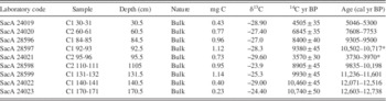
A core 180 cm long, NAR-10, was retrieved using a Russian corer in the eastern part of the Nariani wetland. The core chronology is based on nine AMS (accelerator mass spectrometry) 14C ages determined on bulk sediment (Table 1). Clam v2 (Blaauw, 2010), written for the open-source statistical software R, was used to calibrate the 14C ages with the IntCal13 calibration curve (Reimer et al., Reference Reimer, Bard, Bayliss, Beck, Blackwell, Bronk Ramsey and Buck2013) and to construct an age-depth model. The top of the core (30–0 cm) was not studied because it was impacted upon by modern soil.
List of AMS (accelerator mass spectrometry) 14C dates from Nariani core NAR 10. The 14C ages were calibrated using IntCal13 (Reimer et al., Reference Reimer, Bard, Bayliss, Beck, Blackwell, Bronk Ramsey and Buck2013). Asterisks indicate the rejected ages.

Pollen analysis
Forty-three samples were taken at 2–6 cm intervals for the purposes of pollen analyses. For each sample, 1–2 g of sediment was processed following standard methods in palynology using HCl, KOH baths (Faegri and Iversen, 1989), and heavy liquid flotation (Girard and Renault-Miskovsky, Reference Girard and Renault-Miskovsky1969; Goeury and Beaulieu, Reference Goeury and Beaulieu1979). If significant amounts of silica particles remained, a HF bath was used. After treatment, the residue was suspended in glycerol, mounted onto microscope slides and counted using Zeiss standard and Leica DM 1000 microscopes. Pollen grains were identified using atlases of European and Mediterranean pollen types (Reille, Reference Reille1992; Beug, Reference Beug2004). The pollen concentration ranges from 50,000 to 100,000 grains g−1 in the first part of the sequence (from 180 to 140 cm), and from 150,000 to 300,000 pollen grains g−1 in the second part (from 140 to 30 cm) of the sequence. The pollen sum (reported in the diagram) was higher than 300 in most of the samples. Percentage calculation was based on the total terrestrial pollen (arboreal pollen [AP] + nonarboreal pollen), excluding Cyperaceae and moss and Pteridophyte spores. The diagram was produced using Gpalwin software (Goeury, Reference Goeury1997).
Loss on ignition
Loss on ignition (LOI) analyses were carried out to estimate the organic content of the sediment, following the procedure used by Heiri et al. (Reference Heiri, Lotter and Lemcke2001). Forty samples were collected at 1–3 cm intervals, and these were then dried. Because organic matter is oxidized to carbon dioxide and ash at temperatures between about 200°C and 500°C, the record of sample weights before and after heating (ignition at 550°C during 5 h) allows us to estimate the weight of the organic content. The heating of several test samples to 950°C (for a period of 2 h) in order to estimate the carbonate content yielded so negligible a weight loss (<1%) that this step of the process was abandoned.
Results and interpretation
Chronology, lithology, and LOI
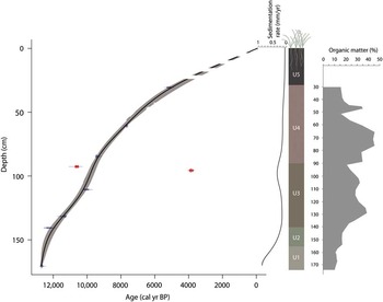
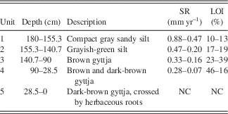
Turning our attention to the age-depth model (Fig. 3), one date (3570 ± 30 14C yr BP) from a depth of 95.5 cm clearly appeared too young and therefore was rejected. The date at a depth of 93–92 cm was also rejected in the age-depth model because it turned out to be too old. Sedimentation rate (SR) is higher (0.88 mmyr−1) at the base of the sequence (180–141 cm) and then decreases along the sequence to reach 0.05 mm yr−1, except in the middle part (close to 100 cm), where it displays a slight rise up to 0.33 mm yr−1.
(color online) Age-depth model, lithology, and organic matter content of the Nariani sequence. Rejected ages are indicated in red.

The stratigraphy of the Nariani sequence was subdivided into five different units from the base to the top of the sequence according to the sediment color (Table 2).
List of units with their lithology, sedimentation rate (SR), and loss on ignition (LOI). NC, not calculated.

The LOI results (550°C) accord well with the sediment description. The compact, gray to grayish-green sediment at the base (units 1 and 2) has lower organic content (10%–19%), whereas the brown upper part features higher (16%–46%) organic content (Fig. 3). In the lowest deposit (unit 1), the lower organic matter input may reflect limited productivity in the former lake water and poorly developed soils in the catchment area. The LOI tests at 950°C did not reveal significant carbonate content in the Nariani sediment.
Pollen results
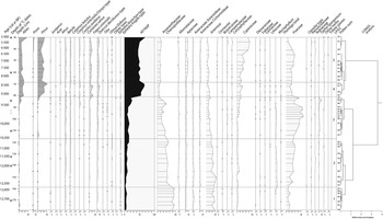
Results of the pollen analyses are presented in the pollen diagram (Fig. 4). Local pollen assemblage zones (LPAZs) have been defined (Birks and Birks, 1980) using the CONISS method (Grimm, Reference Grimm1987). Five main LPAZs have been identified in the Nariani pollen record:
-
∙ LPAZ 1 (depth 178–158 cm) is characterized by a predominance of herbaceous pollen taxa. Pollen assemblages are dominated by Amaranthaceae-Chenopodiaceae (40%–57%), Artemisia (17%–28%), and Poaceae (6%–13%), indicating open vegetation. Other herbaceous families, such as Alismataceae, Apiaceae, and Asteraceae, are well represented. The xeric and steppic taxon, Ephedra distachya t., is frequently identified. Tree and shrub pollen grains are scarce. Betula, Quercus, Fagus, and Pinus are recorded in LPAZ 1, but the AP values (sum of tree pollen grains) never exceed 8%. The end of this zone is marked by a decrease in Amaranthaceae-Chenopodiaceae.
-
∙ LPAZ 2 (depth 158–117 cm) is characterized by relatively stable values for Amaranthaceae-Chenopodiaceae, around 30%. Among herbaceous taxa, Artemisia tends to decrease whereas the Poaceae gradually increase. The environment is still steppic (low AP values). This phase is marked by the significant occurrence of Myriophyllum pollen grains. Myriophyllum is an aquatic taxon, living submerged in water, and its temporary abundance might reflect the presence of permanent water. A very slight increase in tree pollen grains is recorded at the end of this phase (from 10% to 15%).
-
∙ LPAZ 3 (depth 117–81 cm) is characterized by a significant decrease in Amaranthaceae-Chenopodiaceae and Artemisia values, whereas Poaceae values rise significantly, from 27% to more than 58%. The AP values are stable (between 10% and 15%) and increase at the end of the zone (up to 23%). Quercus and Fagus are better represented than in the previous phases. The end of this zone is marked by increasing percentages of Cyperaceae, probably reflecting the beginning of the filling of the lake. A decrease in Poaceae and Amaranthaceae-Chenopodiaceae values is recorded at the same time. The end of LPAZ 3 is also characterized by a weak increase in AP values (exceeding 20%).
-
∙ LPAZ 4 (depth 81–69 cm) is characterized by a simultaneous and significant expansion of Abies and Pinus, suggesting a rapid colonization by coniferous trees in the environs of Nariani. Among the deciduous trees, Fagus displays the same rise (up to 13%) as the coniferous trees but is lower in intensity. Quercus shows a slightly increasing pollen curve (4%–9%). The tree taxon Ulmus/Zelkova displays a continuous curve, and Corylus a semicontinuous curve. AP values reach 65% in this phase. The rise in Cyperaceae, initiated in the previous phase, continues. Poaceae and Amaranthaceae-Chenopodiaceae record a decline within this zone. The end of this phase is characterized by a clear decrease of Pinus and a slight decrease of deciduous trees such as beech (Fagus) and oak (Quercus).
-
∙ LPAZ 5 (depth 69–30 cm) is characterized by almost constant tree pollen values (AP), reflecting relative stability in the contributions of the different tree taxa. Spruce (Picea), which was sporadically present in the previous phase, occurs in greater quantities in this zone. Among herbaceous pollen taxa, the main relevant change is observed in Cyperaceae values, which increase significantly at the end of the phase. The Poaceae values decrease at the same time.
Diagram of selected pollen data from Nariani versus age in cal ka BP. AP, arboreal pollen; LPAZ, local pollen assemblage zones; NAP, nonarboreal pollen. Pollen values lower than 0.5% are represented by dots. Gray stars correspond to rejected 14C dates.

Discussion
Vegetation history inferred from the Nariani pollen record
A two-step steppic phase
The pollen record for the lower Nariani deposits (LPAZs 1 and 2) indicates a steppic and arid environment from 12,700 to 10,500 cal yr BP. For the first part of this phase (LPAZ 1, 12,700-12,500 cal yr BP), Amaranthaceae-Chenopodiaceae and Artemisia together represent more than 70% of the pollen assemblages. Poaceae and other herbaceous plants, such as Asteraceae and Apiaceae, are also observed. Steppic conditions are reflected by the frequent occurrence of the well-dispersed pollen of Ephedra (Connor, Reference Connor2011). Such vegetation, dominated by Amaranthaceae-Chenopodiaceae, is characteristic of glacial phases recorded in the two regional long sequences: Lake Urmia (Djamali et al., Reference Djamali, de Beaulieu, Shah-hosseini, Andrieu-Ponel, Ponel, Amini and Akhani2008) and Lake Van (Wick et al., Reference Wick, Lemcke and Sturm2003; Litt et al., Reference Litt, Pickarski, Heumann, Stockhecke and Tzedakis2014). Similarly, a dry steppe is also observed during the Younger Dryas at Lake Paravani (Messager et al., Reference Messager, Belmecheri, von Grafenstein, Nomade, Ollivier, Voinchet and Puaud2013). In the eastern Mediterranean and the Middle East, the Younger Dryas event is marked by increasing climate aridity (Bottema, Reference Bottema1995; Wick et al., Reference Wick, Lemcke and Sturm2003; Wright et al., Reference Wright, Ammann, Stefanova, Atanassova, Margalitadze, Wick and Blyakharchuk2003).
In the second part of this steppic phase (LPAZ 2, 12,500–10,500 cal yr BP; see Fig. 4), Artemisia and Amaranthaceae-Chenopodiaceae are still dominant, but their proportions decrease slightly, possibly suggesting more humid conditions. Like in the Paravani sequence, the steppic phase spans the Younger Dryas, but also part of the early Holocene. In Lake Aligol (1540 m asl, Tsalka Plateau), a short-lived pioneer phase, composed of Corylus and Betula, was recorded between 12,000 and 11,000 cal yr BP (Connor and Sagona, Reference Connor and Sagona2007). However, neither the Paravani nor Nariani sequences, located at higher altitudes, display this phase. The abundance of Myriophyllum at this time can be interpreted as a sign of the presence of permanent water. However, because Myriophyllum can grow in a wide range of water depths (from a few decimeters to 7–8 m), it is difficult to make definite inferences regarding lake water levels.
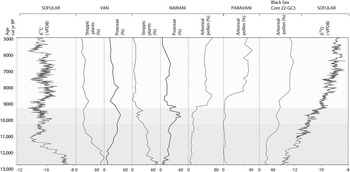
From 10,500 to 9000 cal yr BP, the steppic vegetation evolved progressively (LPAZ 3; see Fig. 4) from Amaranthaceae-Chenopodiaceae steppes to grassland. The Poaceae values exceed 50% at the end of this phase (LPAZ 3). This herbaceous dynamic was recognized in the pioneering study carried out by Margalitadze (Reference Margalitadze1977), but in the absence of absolute dating, an age between about 5000 and 3000 cal yr BP was proposed. Such a pattern, characterized by the rise of Poaceae and the decline of Amaranthaceae-Chenopodiaceae, was also described for the Lake Van sequence (Fig. 5) and dated between 11,500 and 9000 cal yr BP (Wick et al., Reference Wick, Lemcke and Sturm2003; Litt et al., Reference Litt, Krastel, Sturm, Kipfer, Örcen, Heumann, Franz, Ülgen and Niessen2009). The same pattern was also observed in other pollen records from the Near East: in Turkey (Eski Acigöl: Roberts et al., Reference Roberts, Reed, Leng, Kuzucuoğlu, Fontugne, Bertaux and Woldring2001) and in Iran (Lake Zeribar: Van Zeist and Bottema, Reference Van Zeist and Bottema1977; Stevens et al., Reference Stevens, Wright and Ito2001; and Lake Urmia: Bottema, Reference Bottema1986). Interestingly, the Paravani pollen record does not display a “Poaceae phase” (Messager et al., Reference Messager, Belmecheri, von Grafenstein, Nomade, Ollivier, Voinchet and Puaud2013). This might be related to the very low SR (sedimentation rate) observed for the early Holocene in the first Paravani sequence studied (PAR 09-01). Some of the new cores, collected in other sites of Lake Paravani basin, yield thicker early Holocene deposits, in which pollen records display significant Poaceae values (more than 30%) for the early Holocene period (work in progress). In the Nariani sequence, the very end of this phase is marked by a decline in grasses and a very slight expansion of trees (from 9500 to 9100 cal yr BP). Such a pattern, showing a moderate initial rise in AP values, is also recorded in the Black Sea core 22-GC3 (Fig. 5). In the Nariani record, this could reflect an initial tree expansion in lower altitude vegetation belts, perhaps even from the western part of the South Caucasus (by long-distance pollen transport). The end of this phase is marked by the decline of Myriophyllum and the beginning of the Cyperaceae expansion. This probably indicates a lowering of the lake level inducing the colonization of exposed shores by sedges. In such edaphic conditions, some hygrophytic species of Poaceae (i.e., Phragmites) could have grown and contributed to the Poaceae pollen increase we observed.
Comparison of several records from the Black Sea region, showing isotopic data from Sofular stalagmites (Fleitmann et al., Reference Fleitmann, Cheng, Badertscher, Edwards, Mudelsee, Göktürk and Fankhauser2009) and pollen data from Lake Van (Wick et al., Reference Wick, Lemcke and Sturm2003), Nariani (this study), Lake Paravani (Messager et al., Reference Messager, Belmecheri, von Grafenstein, Nomade, Ollivier, Voinchet and Puaud2013), and Black Sea core 22-GC3 (Shumilovskikh et al., Reference Shumilovskikh, Tarasov, Arz, Fleitmann, Marret, Nowaczyk, Plessen, Schlütz and Behling2012). Except for Paravani and Nariani, the pollen curves are based on pollen data from the European Pollen Database (http://www.europeanpollendatabase.net), VPDB (International reference standard “Vienna Pee Dee Belemnite”).

Forested phase
The onset of the forested phase, starting around 9000 cal yr BP, is marked by a significant expansion of trees. Although the AP values rapidly reach 50%, they never exceed 65% during the more forested phase (LPAZ 4). In the neighbouring Paravani pollen record, the AP values also increase rapidly but reach more than 80% (Messager et al., Reference Messager, Belmecheri, von Grafenstein, Nomade, Ollivier, Voinchet and Puaud2013). The question of over- or underrepresentation of trees in pollen records from the Javakheti highlands has already been addressed (Kvavadze, Reference Kvavadze1993; Connor, Reference Connor2011; Messager et al., Reference Messager, Belmecheri, von Grafenstein, Nomade, Ollivier, Voinchet and Puaud2013), and the Nariani paleolake is likely to have been smaller than Paravani, thus probably limiting the “tree overrepresentation effect” seen in large lakes. In the Nariani sequence, the main trees undergoing expansion at the time are pines (Pinus), firs (Abies), and beeches (Fagus). The Abies and Fagus tree taxa do not currently grow in the Nariani watershed, but they are well developed in the Bakuriani area located only 10–20 km to the northwest (see Fig. 2). Considering the low representation of Abies in modern pollen rain on the Javakheti Plateau (Connor et al., Reference Connor, Thomas, Kvavadze, Arabuli, Avakov and Sagona2004; Connor, Reference Connor2011), its significant values in the Nariani record (10%–30%) indicate that fir forests were probably well developed and could have expanded on the Javakheti Plateau at that time. Compared with the Paravani record, the more significant values for Fagus and Abies indicate the presence of higher-altitude vegetation belts in the Nariani area.
The trees representing lower vegetation belts, such as oak (Quercus), elm (Ulmus), or hornbeam (Carpinus), are also recorded in Nariani, but in lower proportions. They probably reflect the midaltitude forest belt that developed on lower plateaus, such as the Tsalka Plateau (Connor, Reference Connor2011). Just prior to 8000 cal yr BP, the tree cover decreased slightly to reach a phase of equilibrium between the different forest formations and the grassland. This situation lasted at least until 5000 cal yr BP (end of the sequence; Fig. 4). Among the herbaceous taxa, no sign of human impact has been detected, and the development of Cyperaceae in the upper part of the sequence probably reflects the filling of Lake Nariani.
Deciphering the delayed forest expansion recorded in Nariani
In the Nariani pollen record, the beginning of the Holocene is not characterized by the expansion of trees as observed in most of the pollen records from western, northern, and central Europe (Huntley and Birks, Reference Huntley and Birks1983; Watts et al., Reference Watts, Allen, Huntley and Fritz1996). Steppes were still the preponderant vegetation type during the early Holocene, as observed in other paleoenvironmental records from southeastern Europe and the Near East (Van Zeist and Bottema, Reference Van Zeist and Bottema1977; Bottema, Reference Bottema1986; Stefanova and Ammann, Reference Stefanova and Ammann2003; Wright et al., Reference Wright, Ammann, Stefanova, Atanassova, Margalitadze, Wick and Blyakharchuk2003; Djamali et al., Reference Djamali, de Beaulieu, Shah-hosseini, Andrieu-Ponel, Ponel, Amini and Akhani2008, Reference Djamali, Akhani, Andrieu-Ponel, Braconnot, Brewer, de Beaulieu and Fleitmann2010; Connor et al., Reference Connor, Ross, Sobotkova, Herries, Mooney, Longford and Iliev2013; Leroy et al., Reference Leroy, Tudryn, Chalie, Lopez-Merino and Gasse2013, Reference Leroy, Lopez-Merino, Tudryn, Chalie and Gasse2014). In the South Caucasus, this delay is well recorded in different sequences, such as those from Gomnis (Margalitadze, Reference Margalitadze1995), Paravani (Messager et al., Reference Messager, Belmecheri, von Grafenstein, Nomade, Ollivier, Voinchet and Puaud2013), Zarishat (Joannin et al., Reference Joannin, Ali, Ollivier, Roiron, Peyron, Chevaux, Nahapetyan, Tozalakyan, Karakhanyan and Chataigner2014), and Vanevan (Leroyer et al., Reference Leroyer, Joannin, Aoustin, Ali, Peyron, Ollivier, Tozalakyan, Karakhanyan and Jude2016). Depending of the sequences studied in the South Caucasus, the afforestation event ranges from 9200 cal yr BP (Nariani) to 8000 cal yr BP (Zarishat: Joannin et al., Reference Joannin, Ali, Ollivier, Roiron, Peyron, Chevaux, Nahapetyan, Tozalakyan, Karakhanyan and Chataigner2014). However, one has to consider a relative synchronicity in these ages because of dating and age-depth model uncertainties. Different hypotheses have already been proposed to explain this pattern: (1) the time lag in tree migration from glacial tree refugia; (2) the impact of burning (Roberts, Reference Roberts2002; Turner et al., Reference Turner, Roberts, Eastwood, Jenkins and Rosen2010); (3) a relatively dry early Holocene climate (Van Zeist and Bottema, Reference Van Zeist and Bottema1991; Roberts and Wright, 1993; Stevens et al., Reference Stevens, Wright and Ito2001, Reference Stevens, Ito, Schwalb and Wright2006; Wright et al., Reference Wright, Ammann, Stefanova, Atanassova, Margalitadze, Wick and Blyakharchuk2003; Djamali et al., Reference Djamali, Akhani, Andrieu-Ponel, Braconnot, Brewer, de Beaulieu and Fleitmann2010); and (4) a negative feedback from the “Black Lake” preceding the filling of the Black Sea by Mediterranean waters (Leroy et al., Reference Leroy, Tudryn, Chalie, Lopez-Merino and Gasse2013).
The time lag in tree migration
The delay in afforestation could be explained by a slow eastward postglacial migration of trees from their refugia. In the South Caucasus, the Colchis region (located in western Georgia, bordering the Black Sea) is considered to be the main glacial tree refugia (Shatilova and Ramishvili, 1990; Kvavadze et al., Reference Kvavadze, Bukreeva and Rukhadze1992; Connor and Kvavadze, 2008). According to different climatic model simulations (different ECHAM models), the eastern coast of the Black Sea and the southwestern coast of the Caspian Sea were highlighted as possible refugia for summer-green trees during the Last Glacial Maximum (Leroy and Arpe, Reference Leroy and Arpe2007; Arpe et al., Reference Arpe, Leroy and Mikolajewicz2011). This area is located only 150 km from the Javakheti Plateau. Of course, the Javakheti Plateau is separated from the refugia by mountains, but there are no high mountain barriers in this part of the Lesser Caucasus, and there are quite large valleys, which would have permitted the reexpansion of trees. The simultaneous expansion of the different tree taxa, recorded in both Nariani and Paravani, shows that as soon as regional climatic conditions were favorable on the Plateau, the trees were able to reach the Javakheti Plateau concurrently (Messager et al., Reference Messager, Belmecheri, von Grafenstein, Nomade, Ollivier, Voinchet and Puaud2013).
The impact of early Holocene burning
The role played by grassland burning, as a brake on the woodland expansion of the early Holocene, has already been investigated (Roberts, Reference Roberts2002; Turner et al., Reference Turner, Roberts and Jones2008, Reference Turner, Roberts, Eastwood, Jenkins and Rosen2010). In the Eski Acigöl sequence (Anatolia), there is a positive correlation between grass pollen and microcharcoal frequency between 15,000 and 8000 cal yr BP, “implying that summer grass fires accounted for a significant part of the regional atmospheric charcoal flux” (Turner et al., Reference Turner, Roberts and Jones2008, p. 321). An increase in fire activity is also recorded for the early Holocene in the Lake Van sequence (Wick et al., Reference Wick, Lemcke and Sturm2003). Is this pattern due to wildfires or anthropic fires? The question of landscape management through deliberate burning by early Neolithic populations has been examined (Roberts, Reference Roberts2002; Turner et al., Reference Turner, Roberts, Eastwood, Jenkins and Rosen2010). For the Javakheti Plateau, although charcoal analysis has not yet been undertaken on the Nariani and Paravani cores, regional fire signals reconstructed from Aligol (Connor, Reference Connor2011) and Zarishat (Joannin et al., Reference Joannin, Ali, Ollivier, Roiron, Peyron, Chevaux, Nahapetyan, Tozalakyan, Karakhanyan and Chataigner2014) records may be considered. Situated on a neighbouring plateau (Tsalka region), the charcoal concentrations from Lake Aligol (Connor, Reference Connor2011) remain very low until the late Chalcolithic (i.e., 5300–5000 cal yr BP). In Zarishat, there is no significant charcoal input before 5500 cal yr BP. Therefore, these regional results do not reveal any fire impact during the time lag in forest expansion (11,500–8000 cal yr BP). Nonetheless, charcoal analysis will be carried out on the Paravani and Nariani sequences in order to test the correlation between Poaceae and fire intensity. However, a potential impact because of early Neolithic fires is unlikely in this part of the South Caucasus because the oldest Neolithic sites identified so far date to 8000 cal yr BP at the earliest (Hamon et al., 2016).
The question of seasonality
Despite the fact that Nariani and other regional pollen records indicate ongoing arid climatic conditions, geochemical and isotopic indicators from Lake Van (Lemcke and Sturm, Reference Lemcke and Sturm1997; Wick et al., Reference Wick, Lemcke and Sturm2003), Lake Eski Acigöl (Roberts et al., Reference Roberts, Reed, Leng, Kuzucuoğlu, Fontugne, Bertaux and Woldring2001; Jones et al., Reference Jones, Roberts and Leng2007), and Nar Gölü (Dean et al., Reference Dean, Jones, Leng, Noble, Metcalfe, Sloane, Sahy, Eastwood and Roberts2015) in Turkey, show much higher water levels and/or lower salinities during the early Holocene. The hypothesis of higher precipitation is also supported by stalagmite records (Bar-Mathews et al., Reference Bar-Matthews, Ayalon, Kaufman and Wasserburg1999; Fleitmann et al., Reference Fleitmann, Cheng, Badertscher, Edwards, Mudelsee, Göktürk and Fankhauser2009; Göktürk et al., Reference Göktürk, Fleitmann, Badertscher, Cheng, Edwards, Leuenberger, Fankhauser, Tüysüz and Kramers2011). These results suggest increasing annual precipitation during the early Holocene but do not necessarily contradict the pollen data. In fact, one of the key bioclimatic parameters that control the growth and development of tree populations is spring (and late spring) precipitation. So, although the annual precipitation might have increased during the early Holocene, the forest expansion was probably limited by low spring precipitation (lack of water during the growing season of trees). The “wet early Holocene” identified by means of lacustrine geochemical and isotopic indicators, as well as stalagmite records, could be the result of increased precipitation in winter and/or in fall (Brayshaw et al., 2011; Göktürk et al., Reference Göktürk, Fleitmann, Badertscher, Cheng, Edwards, Leuenberger, Fankhauser, Tüysüz and Kramers2011; Dean et al., Reference Dean, Jones, Leng, Noble, Metcalfe, Sloane, Sahy, Eastwood and Roberts2015). The winter snowfalls may have melted during spring and summer, thereby generating higher lake stands.
The seasonality of precipitation may be one of the “keys” to understanding the regional ecological shift that occurred throughout the early Holocene, and this issue is the subject of much debate (Arz et al., 2003; Tzedakis, Reference Tzedakis2007; Rohling et al., Reference Rohling, Abu-Zied, Casford, Hayes and Hoogakker2009; Göktürk et al., Reference Göktürk, Fleitmann, Badertscher, Cheng, Edwards, Leuenberger, Fankhauser, Tüysüz and Kramers2011). For the Mediterranean basin, different scenarios, including the following, have been proposed for the period of sapropel deposition (between ~9 and 6 cal ka BP): (a) an increase in summer precipitation (Rohling et al., Reference Rohling, Abu-Zied, Casford, Hayes and Hoogakker2009) and (b) enhanced autumn/winter precipitation (Tzedakis, Reference Tzedakis2007). For the Black Sea basin, the Nariani pollen record tends to support the hypothesis of increasing autumn/winter rainfall at the beginning of the Holocene, followed by a transition period marked by a slight increase in spring-summer precipitation from 10,500 to 9000 cal yr BP, which is indicated by the replacement of Amaranthaceae-Chenopodiaceae by Poaceae steppes. This hypothesis has already been proposed based on the expansion of Poaceae (Rossignol-Strick, Reference Rossignol-Strick1995). These phases are finally followed by a marked increase in spring-summer rainfall beginning between 9000 and 8000 cal yr BP. The hypothesis of increasing spring rainfall has also been proposed on the basis of δ18O values from Zeribar Lake in western Iran (Stevens et al., Reference Stevens, Wright and Ito2001) and Lake Van in Turkey (Wick et al., Reference Wick, Lemcke and Sturm2003). For this region (Near East), the influence of the Indian summer monsoon has already been proposed to explain the shift from a Mediterranean-type climate to one dominated by spring precipitation, which would have favoured the expansion of deciduous oak forest just after the early Holocene (Djamali et al., Reference Djamali, Akhani, Andrieu-Ponel, Braconnot, Brewer, de Beaulieu and Fleitmann2010). In the Caucasus region, the climate reconstructions based on pollen data from Zarishat Fen, in Armenia, also support increasing spring rainfall after 8000 cal yr BP (Joannin et al., Reference Joannin, Ali, Ollivier, Roiron, Peyron, Chevaux, Nahapetyan, Tozalakyan, Karakhanyan and Chataigner2014), but understanding the mechanisms controlling this climatic shift remains a challenge.
The Black Sea influence
In the Black Sea pollen records (Fig. 5), an abrupt increase in deciduous tree pollen is recorded between 9000 and 8000 cal yr BP (Atanassova, Reference Atanassova2005; Shumilovskikh et al., Reference Shumilovskikh, Tarasov, Arz, Fleitmann, Marret, Nowaczyk, Plessen, Schlütz and Behling2012; Filipova-Marinova et al., Reference Filipova-Marinova, Pavlov, Coolen and Giosan2013). The δ18O signature recorded in Sofular stalagmites (Fig. 5) reflects the increasing input of Mediterranean water into the Black Sea (Badertscher et al., Reference Badertscher, Fleitmann, Cheng, Edwards, Göktürk, Zumbühl, Leuenberger and Tüysüz2011). The opening of the Black Sea corridor led to the conversion of lacustrine waters to marine waters (Ryan et al., Reference Ryan, Pitman, Major, Shimkus, Moskalenko, Jones, Dimitrov, Gorür, Sakinç and Yüce1997; Bahr et al., Reference Bahr, Arz, Lamy and Wefer2006; Bardertscher et al., 2011). The emergence of a larger water body, which was marine in nature, in the Black Sea Basin, probably played a major role in determining the nature, quantity, and rhythm of rainfall in the neighbouring regions. Although the Black Sea effect on vegetation in the western South Caucasus is significant at the present time (Volodicheva, Reference Volodicheva2002), its role in the regional climatic mechanism during the early Holocene is not well understood (Göktürk et al., Reference Göktürk, Fleitmann, Badertscher, Cheng, Edwards, Leuenberger, Fankhauser, Tüysüz and Kramers2011).
The change in precipitation seasonality, as attested to by the Nariani and Paravani pollen records, is almost simultaneous with the process of Black Sea opening during the early Holocene. However, further palaeoecological and palaeoclimatic studies are required to clarify these complex relationships. Further east, in the Caspian Sea records, the period corresponding to the early Holocene (11,500–8400 cal yr BP) and characterized by a major regression (Ollivier et al., Reference Ollivier, Fontugne and Lyonnet2015, Reference Ollivier, Fontugne, Lyonnet and Chataigner2016), is marked by a shrub phase associated with low AP values (Leroy et al., Reference Leroy, Tudryn, Chalie, Lopez-Merino and Gasse2013). This has been interpreted as the result of dry climatic conditions in which the two large water bodies (Caspian and Black Seas), filled by cold meltwater, had a negative feedback effect (“lake effect”) by delaying warming (Leroy et al., Reference Leroy, Tudryn, Chalie, Lopez-Merino and Gasse2013). It is worth noting the relative synchronicity (considering the 14C uncertainties) of the end of the steppic phases between the Black Sea basin (9000–8200 cal yr BP, depending on the record) and the southern Caspian Sea basin (8400 cal yr BP). The effect of the Black Sea on the regional precipitation regimes, as well as its potential interactions with the monsoon mechanism (Djamali et al., Reference Djamali, Akhani, Andrieu-Ponel, Braconnot, Brewer, de Beaulieu and Fleitmann2010; Göktürk et al., Reference Göktürk, Fleitmann, Badertscher, Cheng, Edwards, Leuenberger, Fankhauser, Tüysüz and Kramers2011), need to be tested as part of future studies using experimental modeling.
Conclusion
Pollen data from the Nariani paleolake sediment core reveal significant environmental and climatic changes over the last 12,700 years. They indicate semidesert vegetation dominated by Amaranthaceae-Chenopodiaceae, associated with arid climatic conditions during the Younger Dryas and the beginning of the early Holocene. The Nariani record sheds new light on early Holocene vegetation history in the South Caucasus, as it reveals a significant “Poaceae phase” immediately following the Amaranthaceae-Chenopodiaceae semidesert. This transition phase indicates a relative increase in moisture during this period. However, this moisture increase does not appear sufficient for woodland expansion in the Lesser Caucasus at the altitude of Nariani. Between 9000 and 8500 cal yr BP, the vegetation history is marked by a clear shift from open to forested vegetation. The chronology of forest expansion (3 millennia later than in western Eurasia) recorded in Nariani confirms the delay previously observed in the Paravani sequence and in other regional pollen records. The dry climate during the growing season favored steppe vegetation until 9000–8500 cal yr BP. The delay in forest expansion can be interpreted as being the result of variation in seasonal distributions of moisture (transition from an autumn-winter to a spring precipitation regime). The origin of the change in seasonality of precipitation is still open to debate, but the filling of the Black Sea, which occurred at that time, possibly played an essential role.
Acknowledgments
This research was partly supported by the “GATES, Georgian Ancient Transcaucasia: Environments and Societies” LIA (International Associated Laboratory) project, founded by the French Environment and Ecology Institute (InEE, CNRS); the “Past and modern biodiversity” ATM program of the National Museum of Natural History (MNHN); and the ANR (National Research Agency)-12 JSH3-003-01 Orimil project, directed by E. Herrscher. Thanks to L. Perrin for his significant contribution to the fieldwork logistics. Thanks to P. Voinchet for supporting the first expedition at Nariani. Radiocarbon dates were provided by LMC14 Laboratory, Gif-sur-Yvette. We express our gratitude to Rhoda Allanic for correcting the language. Finally, we are grateful to Derek Booth, Robert Booth, and the two reviewers for their suggestions that greatly contributed to improving the paper.