1. DEPTH MEASUREMENT
A knowledge of the depth of water below a ship's keel has always been an important factor in safe navigation. As an old saying has it, “The nearest point of land to a ship is usually the sea bed.” Ancient Egyptian tomb paintings record the use of sounding rods for measuring the depth of water from periods earlier than 3000 BC, and the use of lead and line from about 1500 BC. The lead and line is also mentioned in both the Old and the New Testament of the Bible.
As a primary means of measuring water depth, it has been used to warn against grounding, to prepare for anchoring, for charting, for finding fishing grounds and so on. Even in the largest ships today, there is a lead and line to be used in a port where the water is shallow. Through the ages, the lead and line was used when approaching an unknown port. Either the captain could lower one of his anchors to, say, 10 fathoms and then go slowly until the anchor hit the ground. Or he could have a boat lowered which could go slowly ahead of the ship with a man constantly heaving the lead.
By the beginning of the 20th Century, much of the maritime world was charted. The inclusion of soundings on these charts, at varying densities and to varying degrees of reliability, allowed soundings taken by a ship to be used in a more positive way as an aid to navigation. A sounding observed by a ship could be compared with soundings marked on a chart and, for this purpose, depths of water considerably greater than the draught of the ship were of interest. For measuring these greater depths, sounding machines were developed during the 19th Century, and echo sounders in the 20th Century. As a supplement to depth of water, the nature of the sea bed was also a useful clue to a ship's position, and this was often noted adjacent to sounding information on a chart.
2. LEADLINES
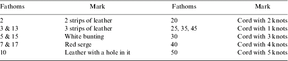
The 20th Century mariner inherited the lead and line in a form with which sailors in antiquity would have been comfortable. The standard leadline, at a time when charts were still marked in fathoms (1·82 metres), was a hemp line marked as in Table 1. In practice, hand leadlines were not usually more than 20 fathoms in length. Such a line would have had a sinker weighing from 3 to 6 kilograms. A hollow in the base of the sinker could be filled with tallow so that a sample of the sea bed could be brought to the surface after a cast. For greater depths of water, a deep-sea lead could be used. This would have a sinker weighing from 12 to 45 kilograms and a hemp line of 100 fathoms or more, wound on a reel.
Leadline markings.
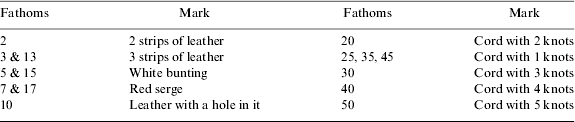
A hand lead could be used from a slow-moving ship, the leadsman casting the lead into the sea ahead of his position at the ship's side and reporting the depth of water when the ship had moved forward so that the leadline was vertical. The leadsman would call a depth “by the mark” if it coincided with one of the marks in the above table, or “by the deep” if it was a whole number of fathoms between marks. Other depths were reported to the nearest quarter of a fathom with fractions preceding the integer number, e.g. “And a half ten,” to report a depth of ten and a half fathoms. Estimates of depths between marks were helped in that a fathom could be taken as the length of line between a man's outstretched arms. At night, when a leadsman could not see the water surface, he would note the mark nearest his hand and subtract the known distance (called the “drift”) between the level of his hand and the surface of the water. The practical use of a hand leadline was limited to depths of up to about 10 fathoms, depending upon the skill of the leadsman and the speed of the ship.
A deep-sea lead could only effectively be used when a ship was stopped or moving slowly. In the latter case, the lead would be cast from a coil of a few fathoms of line by a man standing in the fore part of the ship. The remaining length of line was led outside the ship's rail, clear of all obstructions, to further men standing at intervals along the ship's side and holding similar coils of the line. As the ship progressed, the men would release their coils of line in turn and the last man would attempt to take a reading of the water depth. This was a complex and generally unsatisfactory procedure and the authors have known no-one who has actually been involved in it.
3. SOUNDING MACHINES
As noted above, there was the problem that, when heaving the lead in deep water, the ship's speed had to be reduced considerably to enable the sinker to reach the bottom with the line as close to vertical as possible. The early lines were made of hemp, but friction with the water delayed the time taken for the lead to reach the bottom.
Attempts were made to use wire, which necessitated using a winch. With these, it became possible to obtain useful sounding at greater depths, even with the ship moving at a moderate speed. A knowledge of a ship's speed and the (nearly constant) rate at which the sinker fell through the water, enabled the depth to be calculated from a measurement of the elapsed time between releasing the sinker and it striking the sea bed.
A number of inventors developed sounding devices which depended on the compression of air by water pressure which increases linearly with depth. The Swedish inventor, John Ericsson patented such an instrument in 1836, and Sir William Thomson (later Lord Kelvin) developed his sounding machine through a number of versions culminating in the “Kelvite” Mark IV at the beginning of the 20th Century (Dunn, Reference Dunn2007). Kelvin's design incorporated a glass tube, sealed at one end and coated internally with silver chromate. The greatest penetration of water into the tube during a sounding was indicated by a change of colour in the coating. The corresponding depth was then measured by holding the glass tube against a boxwood scale. Piano wire in the earlier versions was later replaced by a more flexible seven stranded wire.
4. THE ECHO SOUNDER
An echo sounder measures a depth of water by transmitting a pulse of sound vertically downwards from a ship's hull, and measuring the elapsed time before the first echo from the sea bed is received. The development of echo sounders for commercial vessels began after the first World War. Early devices depended on a hammer striking the ship's hull and a hydrophone to detect the returning echo. However, it was not easy to distinguish the weak echo from other audio-frequency noise surrounding the ship. It was not until the introduction of a satisfactory depth recording system in 1930 and the first high-frequency magnetostriction oscillator in 1934 that the echo sounder became a trusted and increasingly fitted device in merchant ships. (Hughes, Reference Hughes1949).
5. USING DEPTH INFORMATION
Measurement of the depth of water has always been an important, although sometimes neglected, source of information for the safe navigation of a ship. In the mid 20th Century, before radar was commonly fitted to merchant ships, the principal methods of navigation were astro when out of sight of land, and compass bearings of landmarks, seamarks and lights when coasting. In overcast conditions, astro was not available and, in poor visibility, none of the above methods could be used. Radio direction finding (RDF) comprising bearings from non-directional beacons (NDBs) were an alternative but they were not widely trusted and tended to be used as a method of last resort. At such times, measurements of the depth of water, and possibly the nature of the sea bed, were an attractive option to back up estimates of a ship's position by dead-reckoning which became increasingly inaccurate with elapsed time since the last reliable fix.
5.1. Warning of danger
In ancient times, the use of a sounding rod or a hand leadline could warn of rapidly shoaling water ahead of a slow-moving boat in sufficient time to prevent stranding. In the 20th Century, a hand lead could be used for the same purpose in a slowly moving ship uncertain of its position. The advent of sounding machines and, more significantly, recording echo sounders, meant that a dangerous shoaling trend could be detected on a faster moving ship in time to prevent stranding. In such circumstances, the standard advice was to turn the ship through 180 degrees, the reverse course being the only one certain to be safe in terms of water depth.
5.2. Defining a Position Line
The increased reliability of charts in the 20th Century gave the possibility of using a measured sounding to define a position line. This was facilitated by the introduction of comprehensive depth contour lines on charts, a policy pioneered by the United States Coast & Geodetic Survey and incorporated in charts of American waters in the 1930s.
Using a recording echo-sounder, it was a simple matter to read the time at which a ship passed over, say, the 20 fathom contour, and this contour would then form a position line. Even before the widespread availability of echosounders, in poor visibility it was sometimes considered worth the considerable labour of locating a depth contour by a series of sounding machine casts. Some bathymetric features leant themselves particularly well to defining position lines, for example steeply shelving ridges or trenches. Others, such as convoluted depth contours, provided ambiguous information that was difficult to use.
5.3. Fixing a Position
In an area where the sea bed was irregular, it was possible to make a number of depth measurements, which could then be plotted against time along a line representing the ship's track. A match to measured soundings, along a line parallel to the ship's course, could then be sought on a chart. In practice, this technique was never much used outside the Board of Trade examination rooms, perhaps because of fears of ambiguity in the contour matching.
As a matter of interest, bathymetric matching became an advanced military technology, particularly for use by submarines, towards the end of the 20th Century. By that time merchant ships had available well developed radar systems and all-weather radio position fixing systems so the technique was no longer needed.
6. THE HAND LEADLINE IN THE MID 20TH CENTURY
6.1. Hand Leadline Experience (Peter Lyon)
While frequently used to sound round the ship when unsure of depths at anchor or alongside, the hand lead was also used when approaching an anchorage, as much for the entertainment of passengers as ‘training’ for the Midshipmen. My recollection is of having to perform this feat during the approach to the Eastern Roads of Singapore.
The lead was swung from the sounding platform; about one metre square, hinged to drop outboard from the starboard side of the centre castle deck, forward of the gangway platform and surrounded by stanchions linked by safety chains. It was located so the leadsman could be seen and, more importantly heard, on the bridge. With the line carefully coiled and the lead armed with tallow, the leadsman would somewhat gingerly step into the ‘chains’ looking along the hull. The inboard end of the line would be secured with the coils of the line held in the left hand and hung over the chains and, with one coil held in the palm of the right hand and gripped with a loop over the thumb, the lead was lowered to just above the sea surface.
The art of heaving the lead to and fro and releasing it at its furthest point forward on the swing while instinctive necessitated an acquired skill. If the lead was swung too high, it would drop back on itself. If the coils of line were not kept free the line would snag and the whole process re-started. If let go too soon the lead would reach the seabed well after the ship had passed over the point of the chains. If the swing was not parallel to the ship's side, a resounding bang would be heard as it struck the hull; alternatively, the lead could land on the foredeck, creating a considerable hazard to the anchor party on their way forward, or indeed to any member of the crew unwise enough to be leaning over the side to give encouragement to the leadsman.
As the lead reached the sea bed, hopefully with the line vertical, it was rapidly hauled back to the chains. The watermark on the line would be detected, traditionally by means of feeling the line with the lips, but usually with fingers, and the reading of the water depth ‘by the mark’, or ‘by the deep’ as appropriate called up to the bridge. This would be continued until the ship reached its anchor position.
The whole operation was geared to a right-handed person. A left-handed person would have to stand in the chains facing aft, to release the lead on a backward swing. There are many expressions that begin with “As useless as a …”. One of the milder ones common to seafarers was “As useless as a left-handed leadsman.”
The lead had other uses once detached from its line. Fishing competitions were always popular during long periods at anchor and would be part of an evening's entertainment to keep the crew from boredom. All would be free to use whatever means (apart from out-of-date distress flares made into depth charges) that might be available to catch fish, with great ingenuity exercised in the choices of lure and bait. At the end of a given period the competition would be halted and the declared winner would be the person with the heaviest catch. On a particularly competitive occasion the angler with the heaviest catch was found to offer a large sucker fish containing the hand lead weight and three beam bolts, but disqualified as the judges refused to believe these additional weights had entered the catch without assistance.
6.2. Hand Leadline Experience (David Page)
The pre-war Athel Line ships did not have echo sounders. Ships built post-war did. Our attempts to suggest a retrofit of the pre-war tonnage produced references to dividends and shareholders, who seemed to be mainly elderly widows according to the Engineer Superintendent. I can remember using the leadline at a Pilots' request in Falmouth in 1947 when moving from anchorage to drydock in fog because, when I reported the depth in fathoms in the time-honoured way as “a quarter less five,” (i.e four and three-quarter fathoms) he asked for the report in feet; no doubt checking up on me. On another occasion I can recollect using the lead when stuck in the mud in the River Plate and waiting for a windshift to raise the water level to allow us up to San Lorenzo.
7. SOUNDING MACHINES
7.1. Sounding Machine Experience (John Kemp)
Even in the middle years of the 20th Century, the Eagle Oil Company ships in which I served were not always equipped with echosounders and we then had to use a Kelvin machine for taking soundings in deep water.
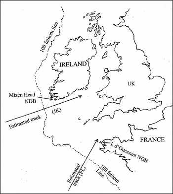
One example of its use was during a voyage from the West Indies to Liverpool. After an overcast Atlantic crossing and no astro observations for several days, attempts were made to find the 100 fathom contour (now replaced on charts by the 200 metre contour). Off the south-west coast of Ireland the 100 fathom contour ran generally north-south (see Figure 1). It therefore made a good cross with a bearing of the radio beacon at Mizen Head. The search was a several hour operation, starting well before the ship was expected to cross the contour. The author and a fellow cadet had the job of re-winding the wire with its heavy sinker after every cast – a testing task for young muscles by the fourth or fifth cast.
Use of Sounding Machine for finding the 100 fathom depth contour by John Kemp and Peter Lyon.

The glass sounding tube, in its metal container, was attached between the sinker and the end of the wire, and the whole was rigged over a block on the taffrail. The second mate was in charge of the operation and we released the brake at his signal by making a half-turn of the handles of the machine. As the wire sang out over the stern, the second mate pressed a metal “feeler” against the running wire. When the sinker hit the sea bed, the feeler sensed the suddenly decreased tension in the wire and the second mate gave the signal for us to apply the brake. This was by a half-turn of the handles in the opposite direction. Not too suddenly or the inertia of the heavy sinker would have snapped the wire. Not too slowly or the sounding tube would touch bottom and fall sideways, resulting in a false reading. When that happened, there was no sharp limit to the discolouration of the coating in the glass tube, and we learned some new (to us) nautical vernacular from the second mate, as well as the finer points of operating a sounding machine.
Having found a 100 fathom sounding at perhaps the tenth cast, the second mate checked his watch and departed with the precious information to the chartroom (see Figure 1). We never learned exactly what use was made of it. In that age, cadets were only tolerated on the bridge to scrub the deck or to polish the binnacle.
7.2. Sounding Machines Experience (Peter Lyon)
The Kelvin sounding machine, which replaced hemp with steel piano wire in the 19th Century, was still very much part of ships' equipment in the 1950s and 60s. Stowed, in my experience, on the starboard side, above and forward of the gangway platform, its varnished boom, or spar, would be lowered outboard on a topping lift and further supported by a guy line or stay leading forward. The wire would be led from the sounding machine reel through blocks to the lead weight suitably primed with tallow to sample the nature of the sea bed.
Apart from the occasional maintenance routine, my sole recollection of its use in earnest was in the traditional hunt for the east-west 100 fathom line on the approaches to Ushant when homeward bound from the Straits of Gibraltar, and only then because of the malfunction of the echo sounder. It was Company policy to pass so far off Ushant that its light could not be seen in poor weather.
The rig was duly set and, at the same time, attempts were made to find a bearing from a shore station using the Radio Direction Finder (RDF), to get a cross with the position line of the 100 fathom contour. (Listening to the RDF was more like a hearing aid test and thus its interpretation was somewhat subjective). The lead would be released by a hand brake and its accompanying screech of the wire running from the reel and through the blocks was repeated at 15 minute intervals in the quest for navigation precision. The electric motor enabled the line to be recovered quite quickly, although winding handles were provided in the event of the failure of the motor. As the handles were located at about head height, the repeated manual recovery of the sounding line would have been an arduous task.
In due course, a sounding of just less than 100 fathoms was achieved and a democratic guess of the RDF bearing made, giving a position fairly close to the Estimated Position (see Figure 1). Ushant was duly found and rounded safely, triggering the setting of double watches through home waters.
A further use of the sounding machine was made in circumstances when the ship had to wait at anchor, often off an Indonesian port for periods of several days. Other co-incident circumstances seemed to be related to timing – shortly after lunch when the Master and Mate could be expected to be taking a nap; the machine's wire reel and blocks were well oiled and the cooks had a drum of kitchen waste ready for disposal. The sounding machine would be rigged, but with the lead replaced by a weighted chicken, stuffed with various pieces of offal and lowered into the sea as shark bait. A catch would usually be made in a fairly short time with the shark landed by swinging the boom around to allow a line to be passed around the shark's tail and hauled on board. The skill, and nimble footwork to avoid the threshing shark, of the Chinese cooks soon produced numerous shark steaks which were quickly despatched below, the deck hosed down and Lord Kelvin's Sounding Machine safely stowed and secured.
7.3. Sounding Machine Experience (Sven Gyldén and Yukito Iijima)
It seems that, by the mid-20th Century, sounding machines were already redundant in many ships, although they were still often fitted in case of need.
Sven Gyldén
In all the ships I sailed in before taking up the job of a pilot, we had mechanical sounding machines in addition to echo sounders, but it never once happened that I got a chance to use one of them. I was, so to speak, born into the echo sounder era. When training for pilot, we had to use a hand lead, although we sorely missed the echo sounder. We had to use our own boat and sounding gear because echo sounders were too expensive in those days.
Yukito Iijima
When I was at sea, the radar was already installed on board and the echosounder was used for approaching to ports. I have no special experiences, but would like to tell a story about the training at nautical school to operate a Kelvin sounding machine. Operating the machine is not easy, especially to sense when the sinker hits the sea bed and one has to haul in the glass sounding tube before it falls down and fills with sea water. In order to give students practical experience, there were sounding machines on the roof of a three-storey building at my college (Tokyo University of Mercantile Marine) fifty years ago. At each machine, there was a vertical down-pipe attached to the wall of the building and each pipe was used as a duct through which the lead sinker and the attached wire could be dropped. Cadets were trained to sense when the lead sinker hit the ground at the bottom of the pipe (representing the sea bed) by holding a “feeler” against the running wire. The Kelvin sounding machines were removed many years ago. However the pipes still survive but nobody now remembers what they were for. Maybe gutters for rain?
7.4. Sounding Machine Experience (David Page)
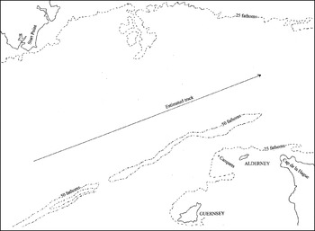
David Page reports having used the sounding machine several times in the late 1940s mainly for practice after routine maintenance, and was surprised how definite an indication there was when the 28lb (12 kg) lead struck bottom, even at ten knots. On one occasion, he was sent aft by the Captain to take a line of soundings as his ship was entering the English Channel after several days without a reliable position fix. As the lead struck bottom on each sounding, DP noted the reading of the Walker log, on the taffrail, and the time. In general, a line of soundings is most useful when there are many changes of depth to be recorded so that these can be matched to the charted depths and thus provide an indication of position (see Section 5.3). This is not the case in Figure 2 where the estimated track is about 30 miles south of Start Point.
Track for a line of soundings in the English Channel (David Page).

In the vicinity of the expected track, the water depth is about 30 to 34 fathoms, with no features to help identify a moderate displacement either along-track or across-track. However, a 10 mile displacement to the south would have been indicated by 50+ fathom soundings associated with Hurd Deep, and a displacement 20 miles north would have been indicated by soundings of less than 25 fathoms associated with the shoal patch off Lyme Bay. In the event, the absence of soundings greater than 50 fathoms or less than 25 fathoms was negative information but, as noted in Section 8·1, knowing where one is not can sometimes be highly reassuring.
8. ECHOSOUNDER
The introduction of the echo sounder as standard equipment on merchant ships, especially when provided with a recording facility, made the finding of depth contours much easier, but it was not welcomed by everyone. One shipmaster, with whom John Kemp sailed, became furious at the not infrequent times when the echo sounder trace did not correspond with the charted depth at his estimate of a DR position. “Turn that bloody thing off!” he would scream. “All it does is tell me we are not where I think we are, – but it doesn't tell me where we are.” He did not appreciate that negative information may be of value. That it can be, is illustrated by the following story.
8.1. Negative Information (Søren Thirslund)
At the end of the 19th Century, we Danes started sailing to the East Coast of Greenland. Due to the pack ice, this was almost impossible with a sailing ship, so the Government had, in 1898, the little wooden steamship Gothaab built in Norway. The first captain was warned that there was a dangerous reef outside Angmagsalik, and someone suggested that, when approaching, he should give a signal with the steam whistle. Then some men would come out in their kayaks and he could ask one of them to guide him to the port.
He did as suggested and sure enough – out came the natives. An interpreter had one of the natives come on the bridge. The captain asked his if he was a pilot. “Yes,” he said. “So you know where the reef is?” The man said, “No.” The captain said, “How can you be a pilot, when you do not know where the reef is?” The answer was, “Because I know where the reef NOT is.”
Probably the main use of the echo sounder in the second half of the 20th Century was in this negative sense, – to provide a warning that a ship was not where it expected to be. This was particularly useful when making a landfall in poor visibility, when coasting, or when approaching an unfamiliar port. An indicated depth significantly less than that along the planned track was a cause for concern. An indication of a shelving sea bed where the depth of water was decreasing steadily toward the ship's draught was a cause for near panic. As noted in Section 5·1, a 180 degree turn was an appropriate response.
8.2. Echo Sounder Experience (John Kemp)
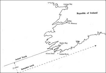
In 1950, John Kemp, still a cadet, was on a ship, again bound for Liverpool, and intending to pick up the Fastnet light and thence follow a track along the southern coast of Ireland. After many overcast days in the Atlantic, the DR position was very approximate and the approach to the Irish coast was made in poor visibility. The echo sounder trace, meanwhile, showed a shelving sea bed and a depth eventually decreasing to less than 25 fathoms – less than it should have been anywhere on the intended track.
A bearing of the Mizen Head radio beacon on the port beam was initially reassuring, until a sheepish Radio Officer announced that his observation had a 180 degree error. Mizen Head was to starboard and the ship was chugging at 12 knots into the cul de sac of Bantry Bay (see Figure 3). The captain immediately did what he had been taught and turned the ship through 180 degrees to make a successful exit from the Bay. An exemplary case of theory actually working in a practical situation. It turned out that the ship had been some 25 miles north of her DR position. Radio bearings had a natural 180 degree ambiguity that was not always easy to resolve.
Use of an Echo Sounder for warning of dangerous shoaling.

8.3. Echo Sounder Experience (Charles Koburger)
The experience of Charles Koburger in United States waters in the mid 20th Century was that measurements of water depth were generally used only as back-up information. In coastal navigation, he explains: “One had to plot ones course over the ground, examining its features, if any. If these features were sharply enough outlined, they could be used for a tertiary or even secondary fix. I do not think that I ever came across a path which had distinct enough features for them to be used for a primary fix. Most of this procedure took place informally, in the navigator's head, of course.”
“Reaching down into the water relied on lead lines first of all, then echo sounders (Fathometers). The Bos'n or able seaman was always proud of his skill with the lead, but the Fathometer was quicker and more accurate. Attention had always to be paid to tides (and currents). There were always problems with water depths, however. For large fishing boats or coastal freighters, the entrance to Coos Bay (Oregon) was deceptive. A swift ocean current here swept across the face of the land from north to south. To enter Coos Bay, one positioned well to the north of the entrance, inside of the considerable, inevitable bar. One then came south, inside the bar, then swung sharp east to enter. Except for small craft, there was no crossing the bar, but every couple of years, someone tried. The entrance and its approaches were buoyed and charted. The sailing directions were clear. If navigators failed to understand them, there is little hope that they did any other navigating.”
Even in his example of Coos Bay, where depth of water is particularly critical, it seems that Charles Koburger's experience is that measurement of water depth was seldom used as a positive navigational tool.
8.4. Echo Sounder Experience (Sven Gyldén)
The value of an echosounder reading is illustrated by the following experiences of Sven Gyldén.
When we were on the North Atlantic run between Scandinavia and the US northeast coast, we normally had a rather uncertain DR position when approaching land on either side. This was because of the weather that seldom provided opportunities for astro positioning en route. At best we could see the sun as a woolly ball through the clouds. This, together with the fact that the horizon was normally very rugged on account of the frequent gales in the area. The normal procedure was always to compare the first RDF and radar bearings with the echo sounder readings.
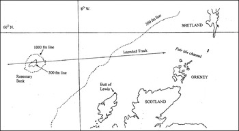
We were lucky in that “the old man upstairs” furnished us with the Rosemary Bank NW of Ireland. We kept a good track of this bank on our Kelvin & Hughes echo sounder, which was extremely good at large depths. It started by giving faint echoes at 700 fathoms and we observed carefully when we passed the 500 fathom line. This line together with an RDF of Butt of Lewis or a position line from the Consol station of Bushmills, gave us a very safe position to shape the next course for the Fair Isle Passage, between the Shetland and Orkney Islands.
On my first trip as second mate in the ship (m/s “Nebraska” of the Transatlantic Shipping Company of Gothenburg) and as such responsible for the navigation, I tried to introduce the former German U-boat navigation system “Sonne” later renamed Consol. I knew that I could find the position within about 5 miles, at least in the North Sea. The Captain and chief officer had some good laughs at my ideas, and comforted me with the advice that I should certainly learn better when I got more experience. Anyway, I persisted and kept on counting dots and dashes on the transmissions from Bushmills, Stavanger and Ploneis. Of course I got tremendously big triangles, but using the centre of inertia of the triangles, I was quite satisfied.
I got my proof on the homeward trip, as I found that we should be passing the 500 fathom curve of Rosemary Bank at a certain log reading. That happened on my watch in the afternoon and, when I marked the echosounder paper at 500 fathoms, the log differed only by 2 cables (0.2 miles) from what I had predicted in the morning (see Figure 4). The chief mate was quite sour at the discovery, but the Captain became very excited and kept on bringing passengers to the bridge to demonstrate when his second mate took Consol positions. I found that the Consol signals were audible and useful about 1500 miles out into the North Atlantic and thus made my job much easier on pitch black and foggy nights. Considering I could only estimate the position to within roughly 5 miles, I had a farmer's luck to end up with only a divergence of 2 cables!
Using the Rosemary Bank for a safe approach to the Fair Isle Channel.

Another occasion when I had use of the echo sounder, was when I and my son went over to Denmark in our small (20 foot) sailing boat the “Gulan”. A couple of hours before our ETA the weather turned really bad, with dense fog reducing the visibility to a minimum and lightning flashes striking the water surface less than 50 metres from the boat. We were approaching the island of Laesö and I had a non-recording echo sounder of the Seafarer 4 brand. I also mistook the reading as I had inadvertently switched the sounder on to the deep range, so when the sounder gave a reading equal to my draft (although I actually still had 20 metres under-keel clearance), I did not dare to continue, so I went in search of deeper water and missed the island of Laesö altogether. By now I had rectified the sounder's scale and I knew that I had found the Danish mainland. I set a new course for the Vesterö harbour, and by luck found one of the channel buoys of Laesö Rende. Now with the sounder readings sorted out it was easy enough to find the harbour entrance even with the rain pouring down and visibility down to zero.
8.5. Echo Sounder Experience (Norman Cockcroft)
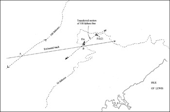
Norman Cockcroft recalls determining position by distance run between crossing depth contours, where the depths were measured by echo sounder. After some 60 years, he cannot identify an actual location, but Figure 5 illustrates the principle.
Position fix by transferred depth contour.

In Figure 5, a ship is approaching the Pentland Firth from the west and is heading 080 degrees to pass ten miles to the north of the Butt of Lewis. When a depth of 100 fathoms is measured, the time is noted and the position A is marked where the estimated track crosses the 100 fathom line. After an interval of time, a 50 fathom depth is measured and position B is marked on the estimated track such that the distance AB is the estimated distance travelled in the observed time interval. Since it is known that the ship's position was on the 100 fathom line at time A, it will be (subject to errors in estimated course and distance) on the transferred section of the 100 fathom line at time B. The ship's position will thus be at the intersection of the 50 fathom line and the transferred section of the 100 fathom line, marked as Fix in Figure 5.
Figure 5 also illustrates that there is the possibility of ambiguous results when one, or both, of the depth contours are convoluted. The transferred position line crosses the 50 fathom line at positions Fix and Fix 2. However this ambiguity could be resolved by noting that the 50 fathom measurement was not the first in the case of Fix 2. Also that further soundings would increase after Fix 2, but would decrease after the position marked Fix.
9. CONCLUSION AND ACKNOWLEDGEMENTS
This paper has been collated to record some personal experiences in the use of depth finding as a primary or secondary aid to safe navigation in the mid-twentieth century. This included warning of danger, defining a position line or position fixing. At that time, few merchant ships were fitted with radar, and many did not have echo sounders. Nowadays, merchant ships are required to be fitted with echo sounding devices conforming to International Maritime Organization regulations; these devices still have a role to play in navigational safety, despite the advent of reliable radar and GPS.
This paper does not, in any way, represent a comprehensive survey of the use made of depth measurements in the 1940s and 1950s. It simply sets out some recollections of a group of old salts whom John Kemp is fortunate to be able to count amongst his good friends. Their contributions to the paper are much appreciated. Additionally, Section 1 of this paper is based on a translation from the “Lead and Line” section of Chapter III in Søren Thirslund's excellent book on the History of Navigation.
Finally, anyone with similar or, better still, different experiences of depth finding techniques in the relevant period is invited to contribute their story to John Kemp, care of the RIN.