INTRODUCTION
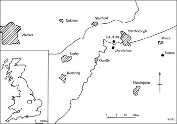
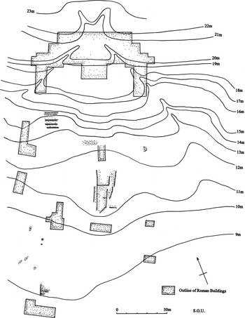
This article provides a summary of various excavations and surveys of a large group of Roman buildings found beneath Castor village, Cambs. (centred on TL 124 984). The village of Castor lies 8 km to the west of Peterborough (fig. 1) and rises on a slope above the first terrace gravel soils of the River Nene to the south. The underlying geology is mixed, with the lower part of the village (8 m AOD) sitting on both terrace gravel and Lower Lincolnshire limestone, while further up the valley side the Upper Estuarine Series and Blisworth Limestone are encountered, with a capping of Blisworth Clay at the top of the slope (23 m AOD).Footnote 1 The slope of the ground on which the Roman buildings have been arranged has not been emphasised enough or even mentioned in earlier accounts of the site.Footnote 2 The current evidence suggests that substantial Roman terracing and the construction of revetment or retaining walls was required to consolidate the underlying geology.
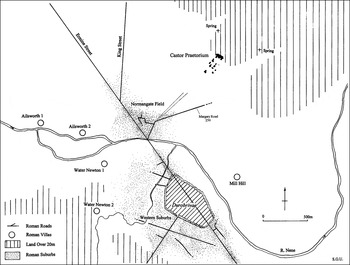
Location of Castor and Durobrivae.

The site lies 1.5 km to the north of the Roman town of Durobrivae and 1 km from the junction of two major Roman roads, Ermine Street and King Street. Roman remains have been reported from the area of the village and the church since the seventeenth century and in 1733 comment was made that Castor ‘as appears by ye ruins, (was) a City of large extent’.Footnote 3 Large-scale antiquarian excavations were carried out by Edmund Artis in the early 1820s when substantial remains of Roman masonry were still visible. Artis recovered the plans of several buildings which he interpreted as one unified structure. He was so impressed by the scale of the building that he termed it the ‘Praetorium’ on his map of 1828.Footnote 4 Throughout the nineteenth and twentieth centuries finds of Roman material were continually made in the area around the church. During the 1970s and early 1980s a series of small-scale excavations in gardens added to the understanding of the site and made considerable additions to Artis' plan. During recent years more information has been accumulated through archaeological watching-briefs, local building developments, and a three-day archaeological intervention by Time Team.
Our current knowledge shows that the Roman building(s) covered an area of 290 by 130 m (3.77 ha), and had at least 11 rooms with tessellated floors and mosaics,Footnote 5 at least two bath-houses and several hypocausts. The masonry which survives points to monumental architecture and the evidence now indicates two major phases of building that may link with political and historical events in the province.
In the post-Roman period the site appears to have had some element of continuity, for there is fifth-century pottery and later eighth-century occupation material from excavated contexts.Footnote 6 A nunnery was supposedly founded at Castor in the mid-seventh century by Cyneburgh (Kyneburgha), daughter of Penda who was the king of Mercia.Footnote 7 The medieval church contains several fragments of eighth- and ninth-century stone sculptureFootnote 8 and there are chance finds of a coin of Offa (c. a.d. 757–796) and a Saxon pin and strap-end, all from close to the church.Footnote 9
ARCHAEOLOGICAL HISTORY OF THE SITE
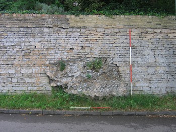
The Roman remains at Castor must have attracted early antiquarian interest owing to the fact that several walls appear to have been standing to a good height even when Edmund Artis surveyed the site in the 1820s. Several sections of wall are still visible to the north-east and north-west of the church (see fig. 2).
Part of a Roman wall incorporated in the later wall of the Castor Rectory on Stocks Hill. Scale in units of 50 cm. (Photo: S.G. Upex)

In 1612 William Camden wrote that ‘the little village of Castor which stands one mile from the river seems to have been part of it [Durobrivae] by the inlaid chequered pavements found here’,Footnote 10 and in 1712 John Morton visited the site of the Roman town of Durobrivae (Chesterton parish, Cambs.) which he described as a ‘Roman station’, but was unsure how the remains he clearly saw at Castor linked with the Roman town. He described Castor as ‘… the Castle or principal Fort or whatever, the Place of Residence of the chief Officer was upon the Hill where the church at present stands’.Footnote 11
In 1724 William Stukeley recorded that ‘below the churchyard the ground is full of foundations and mosaics. I saw a bit of a pavement in the cellar of the alehouse …’.Footnote 12 Stukeley was again at Castor on 10 September 1737 ‘to view the antiquities’,Footnote 13 when he saw several Roman wells and Roman pavements being dug up in the churchyard. He also commented on the fact that the ‘Roman castrum went quite around the church’.Footnote 14 Stukeley's comment about pavements being dug up in the churchyard probably refers to events in early May 1733 when the Secretary of the Peterborough Gentlemen's Society gave an account of ‘… a curious Tessellated Pavement discovered last week in Castor Church yard by ye sexton digging a grave for a poor woman. The squares were very small & of different colours, & so intermixt as to forme larger squares of than a foot w(hi)ch ran thro ye whole work. When washed and cleaned ye colour appeared exceeding bright, but ye whole pavement was so strong cemented together, yt the sexton could get up no one piece of it without defacing it & yt coffin was afterwards layd upon it.’Footnote 15
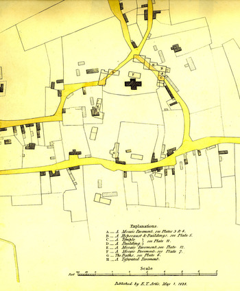
However, the major period of antiquarian work and recording at the site was undertaken by Edmund Artis in the years preceding the publication of his book of plates, The Durobrivae of Antoninus, in 1828.Footnote 16 Artis had been digging in and around Castor for several years and recorded buildings and mosaics from several parts of the Praetorium site.Footnote 17 He was clearly aware of earlier excavations on the site and on the plan he made of the bath-house (marked ‘G’ on his general plan of 1828, and shown here as fig. 3; also shown by Artis in detail in his pl. VI) he indicates the room containing what he thought was the cold bath with a comment ‘Part of the same [room] discovered in the 17th century’, a reference, presumably, to the excavations possibly seen by Morton and Stukeley.
Plate XIII from The Durobrivae by Edmund Artis, Reference Artis1828.

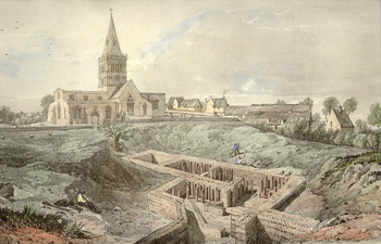
At some time prior to 1823–24Footnote 18 Artis had been digging in the Rectory garden (see fig. 4) and the area of the modern school playing field (Artis pls III, IV, V, VI, VIII); and prior to 1826 in the area called ‘The Cedars’ (Artis pl. XII). In 1828 he produced a general plan of the whole village (Artis pl. XIII; see fig. 3). In addition to the above mentioned plates he also published dated and undated plates of plans and views of his excavations (see figs 5–6).
Castor village showing buildings and areas referred to in the text.

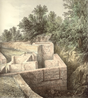
Plate V from The Durobrivae by Edmund Artis, Reference Artis1828, showing the Roman bath-house south of the later medieval church.

Plate II from The Durobrivae by Edmund Artis, Reference Artis1828, showing Roman buildings at Church Hill.

Quite when his general plan of the village (fig. 3) was surveyed remains uncertain, though it may have been some time between 1803 and 1817 if the dated cottages shown in his illustrations are used as a general guide.Footnote 19 It is possible that the survey was originally prepared for use by the Milton estate owned by Earl Fitzwilliam. The estate owned considerable land and property within Castor and may not have required any greater accuracy than is shown in order to deal with property disputes and rents. Thus Artis may have taken such a survey as a basis for his plan and added his overlay of Roman buildings. Some of the Roman buildings he recorded apparently came from his own excavations (see fig. 5), but it is clear that he also recorded some buildings which were revealed when the lanes called Stocks Hill and Church Hill were being lowered in order to produce a more even gradient. Again, it is unclear exactly when this work took place, but it was probably some time around 1810–20.Footnote 20 A considerable number of Roman rooms, which are shown on the Artis plan of 1828 (fig. 3), appear to have been cut by these road works and Artis seems to have recorded what he saw and even seems to have been allowed to clear some of the rooms and make more detailed plans of structures to the north-west of the church along Church Hill (fig. 6). It was probably somewhere in this area that Artis recorded seeing Roman rooms ‘…the walls of which are beautifully painted and from 10 to 11 feet high…’.Footnote 21
The road grading almost certainly accounts for the poor state of preservation of the Roman remains in Stocks Hill, which were re-excavated by Charles Green in 1957–58.Footnote 22 It is possible, however, that the medieval Stocks Hill lane had formed such a hollow way that it had severely cut into the archaeological levels even before the road grading took place, and this is the reason perhaps why Artis did not record the rooms in this area in such detail.Footnote 23
There are several problems and an enormous number of questions posed by the plans and views produced by Artis, which more recent research and excavations have aimed at answering. The scale and accuracy of his drawings are generally good, although some of his small-scale plans seem ‘interpretive’ rather than accurate. In general, his plans are more accurate than his various ‘views’ of the site. For example, his view of the buildings to the north of the church (fig. 6) — which shows room arrangements in a style perhaps more attractive for the general reader of the 1820s — does not match what appears to be a more precise plan of the same rooms,Footnote 24 where size and the layout of wall angles seem more logical and wall lines correspond with those known from the 1970s excavations.Footnote 25 It should be noted that when one makes a comparison between the scale and size of structures on his plans with modern measurements based on recent excavations, there is a fair degree of agreement.Footnote 26
Artis' overall plan (fig. 3) shows some numbered rooms and a series of unnumbered rooms which, in pl. I of the The Durobrivae, he seems to have interpreted as once forming two courtyards: a larger courtyard in the northern part of the site comprising rooms around the later medieval church and extending into the modern school playing field; and a smaller, southern courtyard including buildings he found to the south of the former A47 road. Much of our understanding of the buildings of the Praetorium is based on the work undertaken by Artis, who was operating at a period before the village became built-up. Excavation would have been easier then, and was not restricted to digging in the gardens of modern properties. His view of the bath-house excavations (Artis pl. V; fig. 5), for example, shows the area as a field with the bath-house partly uncovered in the foreground and another small excavation trench (to the left foreground) containing an unnumbered Roman building, which Artis pl. XIII shows to the south of ‘The Cedars’ (see fig. 3).
Artis' overall interpretation of the site was that of a large and possibly public building, hence his term ‘Praetorium’. His excavation techniques were fairly advanced for their day, being both large-scale and systematic.Footnote 27 He understood the size and importance of the arrangements of the separate building units, which he seemed to think were unified. He suggested that the rooms on either side of the church, which sit at the top of the slope, formed opposing ‘wings’ to a central range of rooms and that the eastern wing (Room ‘C’, shown in his pl. XIII; fig. 3) was a temple.Footnote 28 What Artis thought the whole site was used for and how it related to the Roman town of Durobrivae will probably never be fully understood. He planned to publish a second volume containing text, which would have explained both the plates within The Durobrivae and further discoveries he had made, but alas this volume was never printed.Footnote 29
After the death of Artis in 1847 there were other excavations on the site of the Praetorium, although little is known of what was found. A note written in 1904 refers to digging on the north side of the church in ‘Rookery Close’ and ‘no valuable finds of antiques, as the site had been well searched in 1851’.Footnote 30 However, little appears to have been recorded in detail during the late nineteenth century and it is not until the early years of the twentieth century that there are once again references to finds of Roman buildings and mosaics. The Annual Reports of the archaeological section of the Peterborough Historical, Scientific and Archaeological Society, founded in 1871, contain notes on discoveries at Castor with a Mr William Le Queux and Captain S. Walker leading the digging teams. In 1902, for example, they were digging in the south-east corner of the lawn at ‘The Cedars’ (see fig. 4), which was owned by Le Queux, and discovered ‘a bath floor in excellent preservation, paved with square red tiles and probably the atrium to the more extensive Roman Baths, discovered by E.T. Artis, about 1825, north of the site’.Footnote 31 Some of the stonework from these excavations may have been left exposed, along with other fragments of Roman walling in the garden, as indicated in a 1976 magazine article which states that ‘there are still pieces of masonry in other parts of the garden which give evidence of Roman building’.Footnote 32
Again in 1902 it was reported that, ‘In pulling down Colonel White's cottage, south of the church a piece of Roman tessellated pavement, set in red concrete, was discovered …’.Footnote 33 The records that survive do not allow a precise location for this cottage or pavement, but it may have been the site of the ‘L’-shaped cottage partly overlying the bath-house excavated by Artis and shown by him on the map which forms his pl. XIII (fig. 3),Footnote 34 or it could have been the unnumbered Roman building he indicated on the corner of Stocks Hill and the Peterborough Road (the former A47), under part of the present site of the ‘Royal Oak’ public house.
Work during 1957–58, undertaken by Charles and Ida Green, concentrated on two specific areas relating to extensions to the churchyard on the south and east sides.Footnote 35 This work, financed by the then Ministry of Works, saw the excavation of a previously unknown building which may have been a bath-house (see fig. 36) and the re-excavation of the so-called ‘Temple’ site first recognised by Artis (Room C in fig. 3). The bath-house comprised four rooms, some with hypocausts and one with a cement-lined ‘tank’ that may have been a plunge bath. The re-excavation of the ‘Temple’ site fixed the positions of the walls shown by Artis in his drawings and seemed to confirm that the structure indeed had the architectural form of a classical temple, with steps at the front (south side). It was not possible, however, to produce any evidence that supported the view taken by Lewis that the temple originally had a ‘row of prostyle columns’.Footnote 36 Artis' plan shows that he thought the temple-like structure had been linked to the buildings which he saw to the north, but the work by the Greens cast doubts on this, for there were no linking walls found behind the temple-like structure in the area of Stocks Hill Road.Footnote 37
The first systematic survey of the whole of the Praetorium site, since the time of Artis, was published by the Royal Commission in 1969.Footnote 38 This volume listed the known buildings, largely those found by Artis, but with additions made since the 1820s. However, nothing new was added to the overall debate about the range of structures underneath Castor village and no plan was published to show the positions of all the Roman buildings.
Interest in the Praetorium and the problems regarding the full extent of the Roman buildings, their dates and what the overall structure was used for was resurrected in the early 1970s through the work of J.P. Wild and G.B. Dannell. They directed a series of small-scale research excavations during 1970–73 and again in 1980 in the gardens of ‘Elmlea House’ on the north side of the church; cut two trenches in the Rectory garden in 1971 and observed a trench, being dug for drainage, immediately north of the church wall in 1977. In addition, they dug three trenches in 1971 on the site of the bath-house (School Playing Field) that had been identified by Artis in 1828. All this work added considerably to the knowledge of, in particular, the North Range of Roman rooms which lies to the north of the church.Footnote 39 For the first time an architectural balance and cohesion of rooms could be proved and an updated version of Artis' plan produced.Footnote 40 In 1973, Caroline Dallas carried out a further season of work in the gardens of ‘Elmlea’ and explored a Saxon pit and later medieval features, though she also encountered residual Roman material and identified possible Roman surfaces.Footnote 41 Further work was carried out in the gardens of ‘Elmlea’ in 1980 in advance of building development.Footnote 42 This work, directed by Callum Rollo, added details to our knowledge of the north side of the North Range and to the plan already produced by Wild and Dannell. The results of the 1970–80 excavations were used to provide a brief overview of the site at Castor published in 1984, with a reconstruction drawing of what the Roman North Range may have looked like.Footnote 43
From 1980 until the present there have been several ‘developer led’ surveys and excavations based on watching-briefs prior to developments in the area of the Praetorium. These have added some detail to the overall plan of Roman structures within the area of the school buildings and the school playing field,Footnote 44 to the east of ‘The Cedars’,Footnote 45 and to the south of the former A47 in a development based on the conversion of farm barns.Footnote 46 During June 2010 Time Team carried out a three-day investigation and cut five trenches on the site.
Various parts of the site are scheduled under the Ancient Monuments and Areas Act 1979 (shown in fig. 4).
THE EXCAVATIONS OF 1970–80
The aim of the excavations carried out between 1970 and 1980 was to check the position of buildings shown on Artis' plan of 1828 (fig. 3), and also to search for additional rooms or buildings, especially in the area north of the present church where Artis failed to show structures. The village had changed considerably since the time of Artis and the modern excavation trenches were restricted to small, discrete areas of modern gardens. The trench layout was directed not just by archaeological enquiry but by practical horticultural considerations to reduce damage. The trenched areas were consequently small, with the complications that inevitably brings to the interpretation of archaeological features.
ELMLEA HOUSE
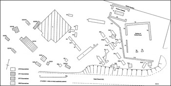
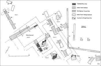
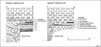
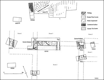
The work in the gardens of ‘Elmlea House’ during 1970–71 was directed by G.B. Dannell and J.P. Wild; in 1973 by Caroline Dallas and in 1980 by Callum Rollo.Footnote 47 The trench plan for all these is shown in fig. 7.Footnote 48 These excavations brought to light the plan of Roman rooms immediately to the west of ‘Elmlea House’ (fig. 7).Footnote 49 Most of the Roman walls here had been robbed (see fig. 9), apart from one small section of rubble wall found in Trench T10. All the rooms had a sub-floor make-up of either mixed clay, mortar and sand, or limestone rubble, on to which opus signinum floors had been laid. The most recent floors in Rooms 10 and 11 (fig. 8) had originally contained central mosaic panels, which had been removed, surrounded by a surviving border of coarser tesserae. It is unclear when these mosaics were removed, but it could have been the work of Artis who may have been digging here at some point after 1828 and, therefore, not recorded in The Durobrivae of that date.Footnote 50 The neatness with which the finer tesserae of the central panel in Room 10 had been removed strongly suggests that the intention was for these floors to be re-laid. A less careful job was done when the floor in Room 11 was removed and some of the smaller, finer tesserae were left in situ (see fig. 10). Enough survived to show that it originally comprised a small polychrome mosaic panel, measuring 2.1 m2. Room 13, to the east of Room 11, contained a coarse tessellated floor. Some of the tessellated floors were laid over earlier floors, as clearly seen in sections cut in Trenches I, XVII and XXIV (see figs 9 and 11). These earlier floors may also have been tessellated, since tesserae were found underneath the later floor levels.Footnote 51
Elmlea House: plan of excavation trenches 1970–80.

Elmlea House: details of excavation trenches in the north-eastern part of the gardens.

Elmlea House: sections through Trench I.

Elmlea House: part of Trench VI (Room 11), showing the remains of the tessellated floor with part of the original central mosaic still in situ, the rest having been removed. Scale in units of inches and centimetres. (Photo: J.P. Wild and G.B. Dannell)

Elmlea House: sections through Trenches XVII and XXIV.

West of Room 10, another larger room (9) was only partially explored (see fig. 8), but appeared to have had an opus signinum floor which was exposed in Trenches XI, XIV and XV. A series of small excavation trenches to the north of Rooms 10–13 suggested the position of a corridor (Room 14), 2.75 m wide and 11.60 m long. Room 14 poses some problems of interpretation owing to the slope of the original Roman ground surface and the small scale of the excavation boxes. It is possible that the area was subdivided into smaller rooms by walls which lay outside the excavation boxes. Alternatively the area may have been one space, but the slope of the ground here would have necessitated at least two steps, possibly represented by the different levels of opus signinum flooring found along the sectional transect (of Trenches XXII, XX, XVIII and XXIII) (see fig. 12).Footnote 52
Elmlea House: sections through Trenches XXII, XX, XVIII and XXIII (Room14; a corridor with steps?).

Beyond Room 14, another large area of opus signinum flooring (see fig. 8) was seen in trenches dug in 1970 and 1980; this has been marked as Room 31. Again, as above, there are problems of interpretation and any possible subdivisions of Room 31 remain a matter of conjecture.Footnote 53
The excavation trenches located at the extreme west end of the ‘Elmlea’ garden (shown in figs 7 and 13) indicate that a further series of rooms lay here. Artis does show some rooms in this part of the Praetorium, where the Roman structures had been cut by the grading of Church Hill at some point in the early 1820s. His view of these rooms, which he illustrated in pl. II (fig. 6) and in his plan (pl. XI, 1), shows walls of typical herringbone masonry with surviving doorways.Footnote 54 These rooms lay immediately south of the rooms described above and appear to have been linked with them to form one large suite.
Elmlea House: excavation trench details in the south-western part of the gardens.

The walls in this part of the building had not been robbed as thoroughly as those to the north-east and the lower courses of limestone masonry survived to indicate the width of the walls and to give some idea of their character. In several cases it was evident that massive stone quoins had been robbed,Footnote 55 leaving the smaller rubble cores of the wall (fig. 13). On average the walls were 1.00–1.30 m wide and were made up of pitched herringbone courses of undressed limestone set in mortar (fig. 14). Trench XXVII produced a well-preserved section of walling (figs 13 and 15), which survived to a height of 1.10 m and was 1.30 m wide; it had been pierced by a hypocaust flue linking the rooms on either side. The width of the walls in this and other parts of the North Range implies a structure that originally could have had several storeys.Footnote 56
Elmlea House: section of herringbone walling forming the northern wall of Room 2 in Trench XXVII; see fig. 13. Both scales in units of 12 inches. (Photo: J.P. Wild and G.B. Dannell)

Elmlea House: the north-western wall of Room 2 in Trench XXVII, looking east and showing the break in the wall line caused by the opening for the hypocaust flue; see fig. 13 for plan. Scale in units of 12 inches. (Photo: J.P. Wild and G.B. Dannell)

None of these rooms had surviving evidence for tessellated floors, although considerable quantities of tesserae of various sizes were recovered and the likelihood is that at least some rooms were tessellated. Several had evidence for opus signinum floors and in some instances (Rooms 1, 2 and 3; fig. 13) these formed the base of a hypocaust, on which the pilae had stood. Many of the walls appear to have been painted, the thick plaster carrying a considerable repertoire of colours. Only one small section of plaster was found in situ in Trench XXXVI, but the rest of the excavation boxes produced large quantities of plaster which had been stripped from the walls during stone robbing.Footnote 57 The quantities of plaster with a coarser white coating may have come from an outside rendering of the structure. Massive quantities of terracotta roofing tiles and the total absence of local Collyweston slates suggest that the roof was tiled.
One problem which the builders of the North Range of rooms faced was that of the slope of the ground. The possible corridor (Room 14; see fig. 8) at the top of the slope could well have had steps along its length, but the builders encountered an even greater slope as they built further to the south. To overcome this problem they appear not only to have provided steps between rooms, which Artis recognised between Rooms 24 and 26 on the eastern side of the North Range (see figs 16 and 33), but also to have terraced into the hillside and retained the earth and rock on the upslope side of rooms. This terracing may account for the huge size (up to 1.43 m wide) of some of the walls (such as that in Trench XXVII; see fig. 15) which acted not only as structural elements of the building, but also as retaining or revetment walls.Footnote 58 Thus each successive room in the western part of the North Range lay at a slightly lower level than its northern neighbour. The basement floor of the hypocaust in Room 2, for example, is 3.40 m lower than the floor of Room 10 at the northern part of the site. Allowing for the hypocaust's suspended floor, the actual living surface in Room 2 would have been about 2.0 m lower than in Room 10.
Plan showing excavation trenches and the wall layout of the east wing of the North Range.

THE RECTORY GARDEN
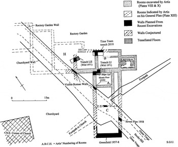
During 1971 two small trenches were dug in the garden of the Rectory (see fig. 4), with a further trench excavated by Time Team in 2010, in order to locate the buildings first shown by Artis in his plans of 1828 (pls VIII and XIII; see fig. 3) and in a view of his excavations shown in pl. X. The position of these trenches is shown in fig. 16. Trench LI cut into the north-western corner of the room that Artis showed as Room ‘3’ in his pl. VIII and Room ‘A’ in his pl. XIII (fig. 3; Room 26 in fig. 33). It revealed both walls (1.10 m wide) and a poorly preserved tessellated floor made up of limestone tesserae (20 × 20 × 20 mm) which was laid on an opus signinum sub-floor. This floor had been extensively exposed by Artis, and he produced two plates (III and IV) which show that it had a central panel with a polychrome geometric design surrounded by a coarse border, which was partly revealed in the 1971 trench.
Trench LII was opened 8 m to the north of Trench LI and located a previously unknown wall which formed a division between rooms in this area. Artis, in his ‘view’ of the site, shows part of a wall which formed the western side of his Room ‘B’,Footnote 59 but he gave no indication of other room divisions beyond that point which would have formed the eastern side of Room ‘H’ (Room 22; see fig. 33). The wall found in Trench LII must have formed this missing wall, and thus acted as the division between two rooms, the one indicated by Artis as ‘H’ and another now labelled as Room 23 (see fig. 33). The recent excavation confirmed that Room 26 had a tessellated floor, while in Room ‘H’ another badly preserved opus signinum floor survived, which may originally have had a tessellated surface (there were large amounts of coarse tesserae in the upper fills), but any trace of this had been obliterated.
These two trenches proved the general accuracy of Artis' plans, which when transcribed onto modern surveys, were shown to be only fractionally out. The excavations by Time Team to the north of Trench LI confirmed a junction between Room 23 and the upper part of Room 24 and also cut into areas which had clearly been excavated by either Artis or other nineteenth-century investigators.
CASTOR CHURCHYARD 1977
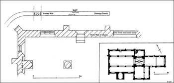
During 1977 a drainage trench was dug in the churchyard 2 m away from the north wall of the church (see fig. 17). There was little chance for excavation, but within the narrow trench a 0.90 m-wide wall of herringbone masonry was recorded, with typical Roman mortar forming the bonding. This wall appeared to be running in a roughly north-north-east to south-south-west direction, although its exact alignment was difficult to confirm. Another spread of limestone was also observed some 4 m to the east of this wall which may have formed a second wall line, but this was very badly damaged. How these walls fit into the overall plan of rooms in the North Range is unclear.Footnote 60
Plan of Roman walls to the north-west of Castor church.

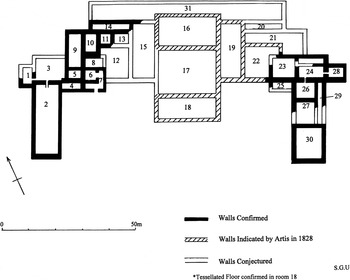
If all the details of the North Range derived from the work of Artis, Green and Wild and Dannell are assembled onto a single plan (fig. 18), it is possible to see how the sketchy overview presented by Artis (pl. XIII; fig. 3) has been extended, especially with the addition of rooms under the gardens of ‘Elmlea House’. An overall plan begins to appear suggesting a single, balanced architectural design for the whole of the North Range, which contrasts with the rather disjointed set of isolated buildings at the bottom of the slope, below the North Range.
Plan showing the known details of the North Range.

There are major problems with the interpretation of the buildings — the North Range — at the top of the slope. This is partly a result of the lack of detail from modern investigation, but also stems from the fact that some of the plans provided by Artis do not seem to have been surveyed accurately. For example, his Room ‘F’ (shown in pl. XIII (fig. 3); Room 18 in fig. 33) appears to be separated from, and at a slightly different alignment to, adjoining rooms to the north-east. This may be owing to the way that Artis discovered the various sets of rooms at different periods of time — or just simple surveying errors.Footnote 61 The other obvious concern is his lack of detail regarding internal divisions in some of the rooms. The interpretation of the North Range will be returned to later.
EXCAVATIONS ON THE BATH-HOUSE IN THE SCHOOL PLAYING FIELD
At the foot of the hill, below the North Range, Artis exposed and recorded a bath-house measuring 28.5 by 19.0 m that he knew had been partly uncovered during the seventeenth century.Footnote 62 It is sited 35 m east of other buildings excavated by Artis, in the garden of ‘The Cedars’ and 27 m west of another Roman building, also shown by him (pl. XIII; fig. 3). He published a splendid general view of the site during excavation (pl. V; fig. 5) and a detailed plan of the bath-house in his pl. VI. Much of the site is now inaccessible beneath the school playing field and the path that leads up to the church from the former A47 Peterborough Road. However, during 1971 permission was given to cut three small trenches at the edge of the playing field to establish the exact position and orientation of the bath-house. Artis' plan of 1828 was shown to be largely accurate. However, the exact orientation of the baths on his general plan (pl. XIII; fig. 3) appeared to be slightly out and the new orientation is shown corrected in fig. 19.
The bath-house first excavated by Edmund Artis and then later in 1971.

The three trenches revealed the positions of four elements in the structure. Room 7 (see fig. 19), as seen in Trench XLI, appeared to have had a hypocaust which is exactly as Artis showed it in his view of the site.Footnote 63 His plan of the baths showed that there had been much earlier stone robbing of the site. However, part of the hypocaust basement floor was found for Room 7 and amongst the debris from this room was a large fragment of coarse tessellated pavement, which may have formed its original upper floor. In addition, a trench dug by Time Team in 2010 produced a small block of white tesserae (5 × 5 × 5 mm) which appears to have come from a figured panel, suggesting that some of the floors in the baths were of a more elaborate design. The eastern end of Trench XLI appeared to cut across one of three small slots (c. 1.0 × 1.80 m) which Artis termed ‘cells’ on his plan; these must have been related to the hypocaust system, although precisely how the ‘cells’ functioned is unclear. These were further explored by the Time Team excavation, but no further light was thrown on their function.
Trench XL, to the south, revealed two other rooms of the baths, and although both had been badly robbed for stone they can be related to Artis' Room 8, which he thought was ‘the dressing room to [for] the cold room’, and Room 9, which he described as a ‘cold bath’. Room 8 originally had a tessellated floor laid on various layers of material which formed a solid sub-floor 0.85 m thick. None of the tesserae for this floor remained in situ, but their impressions were left in the concrete (figs 20–21; Layer 6 in Section A–B). Part of the function of this massive accumulation of floor make-up was to raise the level of the floor to match those of the adjoining rooms which contained hypocausts.
Artis' bath-house: looking west, showing the detail of Roman walling and floor make-up in Trench XL. Scale in units of 12 inches. (Photo: J.P. Wild and G.B. Dannell)

Artis' bath-house: plan and section of Trench XL, 1971.

Room 9 had a much lower opus signinum floor level (fig. 21, Section A–B, Layer 13), which may have formed the lining to the cold plunge bath. The difference in levels between the floors of Rooms 8 and 9 was approximately 0.60 m. Heavy stone robbing, perhaps during the building of the cottages which are recorded on Artis' plan, had removed almost all trace of the wall or sill dividing the cold bath from the cold room. Nineteenth-century pottery in the fill of this robber trench may represent the excavations of Artis, who was attempting to follow wall lines (see Layer 1A in fig. 21).
The wall which formed the division between Rooms 7, 8, 9 and 10 had been damaged and partly robbed, but sufficient remained to show its constructional detail. Courses of pitched herringbone masonry were laid on liberal quantities of a pale yellow mortar with large gravel inclusions (fig. 20). After two or more courses of pitching had been laid, mortar was poured into the construction trench and allowed to partly set before the next course was laid on a new skim of mortar.Footnote 64 This sequence may represent building work on successive days, or perhaps longer intervals of time. There is evidence that the builders had walked on the still-wet mortar surface leaving clear imprints of their hobnailed sandals.Footnote 65
The third trench cut into the baths (Trench XLII) appears to have been placed over the southern edge of the heavily robbed wall line which formed the southern wall of Rooms 8 and 9. This robbing may also have taken place prior to the construction of the cottages which Artis records in this area, or during their subsequent demolition.Footnote 66
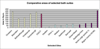
How the baths functioned, the source of water and its supply are a matter of conjecture. Green describes a tiled aqueduct that he found in 1957–58, which led to the bath-house.Footnote 67 However, the comparative size of this structure (72.15 m2) and the bath-house recorded by Artis (337.1 m2) would indicate the need for a much greater quantity of water and a more substantial means of conveying it to the bath-house.Footnote 68 During 2002 residents of Castor surveyed the line of a ‘possible’ aqueduct running from Old Field Pond (TL 132 003) — which is also fed by springs — to the Praetorium site. It was calculated that an aqueduct with a section of 30 by 30 cm could carry a volume of water that was equivalent to a massive 219,229 gallons (997,491 litres) per day.Footnote 69
Artis indicated on his plan (pl. VI) that Room 1 was an ‘ash pit’. Rooms 2, 3, 4 and 7 clearly contained hypocausts, and the ‘cells’ (10) may be linked with the hypocaust system in Room 7. Room 12 (fig. 19, Room 8) is described by Artis as a ‘dressing room to the cold bath’ and Room 9 he describes as the ‘cold bath’. He gives no indication of what he thought Rooms 5 and 6 were, but it seems likely that Room 6 was the praefurnium with a flue leading into Room 4, while another serviced Room 5.
It is not clear how bathers would have used the baths and progressed from cold to warm to hot rooms with this arrangement, especially since the heating source was central to the building. An alternative to the Artis view would be to see Room 1 as a changing-room, with progressively, Room 2 being the cold room, 3 the warm room, and 7 the hot room. This still leaves Room 4 to account for, though this could conceivably have been a sudatorium (hot dry room), while Room 5 could have housed a boiler to provide hot water.Footnote 70 If this were the arrangement, then there still remains the problem of how to interpret Rooms 8 and 9; Artis' changing-room and cold plunge bath. Part of the problem of interpretation is the lack of understanding of any chronological development of the bath-house; Artis' plan suggests alterations in Rooms 1–3 where the thickness of the walls (1.50 m) is much greater than elsewhere in the building, where the walls are 1.0 m thick.Footnote 71
The other question which remains is whether the bath-house was actually an isolated structure or joined to other buildings. Roman buildings exist in the garden of ‘The Cedars’, with others to the east under the school playing field, all of which Artis shows as isolated structures. His ‘view’ of the excavations (pl. V; fig. 5) clearly shows that the southern end of the baths was not fully exposed and it does not illustrate the full extent of Rooms 8 and 9, which his plan, by contrast, does indicate. Pl. V (fig. 5) appears to show another excavation trench — behind the resting workman on the left — which may have held Roman features, although this may be related to the work he did in ‘The Cedars’ garden. The Time Team excavation trench of 2010 (fig. 19) indicated that there were no immediately adjacent rooms or connected structures on the eastern side of the baths, although a geophysical survey carried out to the east of the baths did suggest possible building outlines (see fig. 36).
THE COARSE POTTERY
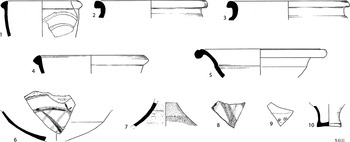
The coarse pottery from the 1970–73, 1977 and 1980 excavations is of little significance because of the very disturbed nature of almost all the deposits which were encountered. The occupation and stone robbing of Saxon, medieval, post-medieval and more recent date have left few sealed Roman deposits in any of the excavated trenches and consequently this hampers the close dating of the buildings. Four sealed deposits were revealed and datable material from these is described below. Two additional sherds are described from Trench L (1973). (Abbreviations: Lower Nene Valley colour-coated ware (LNVCC); Lower Nene Valley grey ware (LNVGW).)
CAS.P. 1970 Trench I, Layer 18 (see figs 7, 8 and 9 and fig. 22 for pottery)
A clay mortar and sand sub-floor which acted as a foundation for the first floor within Room 10, North Range (see figs 8 and 33 for room layout).
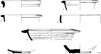
Pottery from CAS.P. 1970. Trench I, Layer 18. Scale 1:4.

1. Beaker with beaded rim and rouletting in LNVCC ware. Greyish brown outer colour-coated surface with lighter brown inner surface; fabric fired to a brown-pink colour. Beakers of this form are fairly common on Lower Nene Valley sites. The kilns from Stanground Park Farm appear to have been producing vessels of this form in the first quarter of the third century.Footnote 72 Similar vessels come from ChestertonFootnote 73 and Normangate Field, Castor.Footnote 74 Howe illustrates two similar vessels, dated to the late second/early third century.Footnote 75
2. Beaker (LNVCC) similar to No. 1 above in colour-coated range and fabric. Slightly heavier rouletting.
3. Beaker with plain rim in LNVCC ware. Inner and outer surfaces light brownish grey. Fabric fired to a light pinkish grey colour. Vessels of this simple form are difficult to date closely unless they are decorated. There are vessels of this type from a kiln group at Stanground (Kiln A)Footnote 76 and they are also known from Chesterton,Footnote 77 Werrington,Footnote 78 and Stonea.Footnote 79 All are dated to the late second century and the first quarter of the third century.
4. Beaker with slightly beaded rim in LNVCC ware. Outer surface light brown, fired to a slightly metallic lustre; inner surface light brown. The rim on this vessel appears to be a variation of the plain rim of No. 3 above; however, this rim type is also found on funnel-necked beakers, which have a slightly later date range.Footnote 80
5. Dish with triangular rim in LNVGW with a light grey fabric. Such vessels are difficult to date since the basic forms appear to last for considerable periods of time. A group of vessels from Chesterton with triangular, rounded and flattened rims have all been dated to the late second to early third centuries,Footnote 81 while similar vessels from Orton Longueville are dated to the end of the second century.Footnote 82 The grey finish on this vessel is not dissimilar to that achieved by the potters working at Sulehay, near Yarwell, who were operating c. a.d. 150.Footnote 83
6. Wide-mouth jar in LNVGW with a light grey fabric. It is difficult to determine the form of this vessel for only a limited amount of the profile can be recovered and what survives does not appear to fit the standard categories of jars found within the Nene Valley. However, the fabric and surface finish are very similar to No. 5 above and this may indicate its date range.
7. Possibly part of a folded or indented beaker in LNVCC ware with vertical impressed lines to mark the divisions between the sections/folds around the girth of the vessel and with a single band of rouletting running above the folds. The outer surface is dark brown fired to a metallic lustre; the inner surface is dark brown and the fabric is an orange-brown. This is not a standard vessel of indented form where the indentations are oval depressions into the wall of the vessel. The wall of this vessel is indented in vertical, straight lines with rounded swellings between. The vessel is at present unparalleled within the LNVCC range of products. The fabric and surface finish of the vessel are similar to that achieved on colour-coated rouletted beakers and indented beakers from Chesterton which are dated to the late second to early third centuries.Footnote 84
8. Fragment of a beaker in LNVCC ware with very dark brown outer surface and dark grey inner surface. The fabric has fired light grey on the inner and grey-pink on the outer wall of the vessel. The outer surface has been decorated with cream painted barbotine lines. Barbotined beakers of this type occur fairly commonly on Nene Valley sites with a date range in the second and third centuries.Footnote 85
9. Small body sherd from a scaled beaker in LNVCC ware. The outer and inner surfaces are dark brown with the fabric fired to a light grey-pink colour. Scaled beakers have a closely dated range within the late second to first half of the third century.Footnote 86
A date range during the late first or early second quarter of the third century would seem appropriate for this deposit.
CAS.P. 1970. Trench I, Layer 12 (see fig. 9 and fig. 23 for pottery)
A limestone and mortar sub-floor which formed a second floor surface within Room 10, North Range (see fig. 33 for room layout).
Pottery from CAS.P. 1970. Trench I, Layer 12. Scale 1:4.

1. Wide-mouthed jar in LNVCC ware. Inner and outer surfaces are reddish brown; the outer surface with a slight metallic lustre. The fabric has fired to a pink-orange. Vessels of this form and finish typically fall within the date range of the late third to early fourth centuries.Footnote 87
2. Flanged bowl in LNVCC ware. Outer surface dark brown, with the inner surface fired slightly darker still; cream-pink fabric. Late third to early fourth centuries.Footnote 88
3. Shallow bowl or dish in LNVCC ware. Inner and outer surfaces are fired a red-brown; pink fabric. Similar date to Nos 1 and 2 above.Footnote 89
4. Pie dish with light brown, slightly burnished finish. Fabric fired dark grey with red-pink outer colour and very small shell inclusions. Similar date range to Nos 1–3 above.Footnote 90
5. Mortarium in pale cream fabric, with pale pink-orange areas on outer surface. Black grit. Similar to the range produced at the kiln site at Stibbington, dated to the late third to fourth century.Footnote 91 The domestic site at Orton Longueville produced two vessels of similar date.Footnote 92
6. Base of a possible imitation samian form (perhaps a 24/5 or a 38?) in LNVCC ware. Inner and outer surfaces are light brown, with a grey-cream fabric. Imitation samian forms seem to be fairly commonly found on Nene Valley sites and usually date to the late third and early fourth centuries.Footnote 93
7. Base of a large wide-mouthed jar in LNVCC ware. Inner and outer surfaces are orange-brown, with a cream fabric. Jars of this size with heavy bases are known from AshtonFootnote 94 and from Orton Hall Farm,Footnote 95 which are dated to the late third and fourth centuries.
This deposit has material in the general date range of the late third to early fourth century and the latest pieces appear to form a possible closing date of c. a.d. 325–335.
CAS.P 1970. Trench XX, Layer 4A (see fig. 8)
From under the floor within Room 14, North Range (see figs 12 and 33).
Sherd (not illus.) identified by the excavatorsFootnote 96 as coming from a bowl from the Stanground kilns and dated to c. a.d. 240–250.Footnote 97
CELM. 1980. Trench 15, Layer 92 (see fig. 8 for plan, and fig. 24 for pottery)
Yellow-grey mortar, opus signinum, gravel and limestone, forming a floor within Room 31 (see fig. 33 for room layout).
Pottery from CELM. 1980. Trench 15, Layer 92. Scale 1:4.

1. Decorated beaker with a bead rim in LNVCC ware. Outer surface dark brown fired to a slight lustre, with slightly lighter inner surface. The fabric is light pink-brown. The shoulder of the vessel is decorated with rouletting and over-painted in a white-cream colour. Decorated funnel-necked beakers of this type are known from several local sitesFootnote 98 and date from the third and into the fourth centuries. The nearest parallels for this vessel are probably those in the collection at Peterborough Museum, which are third-century in date.Footnote 99
2. Beaded rim of beaker in LNVCC ware. Outer and inner surfaces dark brown, with both fired to a metallic lustre. Brown-grey fabric. A similar but smaller vessel to No. 1 above; possibly a similar date range.
3. Plain rim beaker in LNVCC ware. Inner and outer surfaces dark brown, with a light brown fabric. Decorated with a groove and white over-painted lines. Similar plain rim beakers are found within sealed deposits at Orton Longueville,Footnote 100 ChestertonFootnote 101 and, with slight variation, Stonea;Footnote 102 all date to the middle of the third century.
4. Lower part of a Castor ware box in LNVCC ware. Inner and outer surfaces light orange, with a light orange-grey fabric. Decorated with rouletting applied in two bands, each using a different rouletting wheel. Castor boxes seem to develop typologically in size, angularity of profile and decoration through time. This vessel has a very angular lid-seat and can be paralleled by vessels from Chesterton which date to the early to mid-third century.Footnote 103
5. Plain rimmed beaker in LNVCC ware. Outer surface fired purple-brown with a slight lustre; the inner surface is red-brown and the fabric is pink-orange. A rim sherd without any sign of decoration. It is uncertain whether this vessel was a funnel-necked indented beaker or some form of pedestal beaker.Footnote 104 Whichever, a date within the mid- to late third century is likely and the surface finish and fabric would corroborate this.
6. Body sherd of a small jar or beaker in LNVCC ware. Inner and outer surfaces grey-brown with a slight lustre; fabric light brown. Two external bands of rouletted decoration have in turn been over-painted with a light brown-grey paint. It is difficult to know precisely what form of vessel this sherd comes from. The bulbous profile is similar to beakers of the fourth century, but they normally have thicker walls and are much heavier vessels. It may have taken the form of a small bottle-type vessel, but with no exterior decoration, as illustrated by Perrin,Footnote 105 which is dated to the late second to early third centuries. The decoration, fabric and surface finish of this vessel may point to a date in the mid-third century.
7. Base of a LNVCC beaker. Outer and inner surfaces in light brown-orange, with a grey fabric. Some mottling on the coating was caused by finger impressions on the base of the vessel. The precise form of this vessel is unknown, but it is presumably from some form of beaker and probably dates to the third century.
8. Small body sherd in self-coloured cream ware, probably from a narrow-mouthed jar. The inner surface is cream; the outer surface slightly yellow on a cream fabric. Over-painted in dark brown, which in part has thinned to an orange colour. Painted jars of the late second to third century are well represented within the Lower Nene Valley and this sherd may come from a similar vessel.Footnote 106
9. Small body sherd from a beaker or jar in LNVCC ware. The outer surface is light brown and has been fired to a glassy lustre, which then appears to have been over-painted with lines of pink paint. The inner surface is dark brown on a pink-grey fabric. A very well fired vessel of a type not commonly found within the Lower Nene Valley; probably third century.
10. Jar in LNVGW. Inner and outer surfaces fired to a light grey on a cream-grey fabric. This jar has a fabric and finish similar to the mid-second-century vessels which come from the kiln at Sulehay,Footnote 107 though the form of the jar is more akin to vessels from Stanground dating to the early third centuryFootnote 108 and a vessel from Sibson dating to the late second or early third century.Footnote 109
11. Dish in LNVCC ware. Outer and inner surfaces fired to a dark grey on a light grey fabric. Large dishes or bowls with flattened or rounded rims are common in the third century and this vessel matches examples from Chesterton, which are dated to the early part of that century.Footnote 110
12. Wide-mouthed jar in shell-gritted ware. The outer and inner surfaces are a light pink-grey with some darkening towards the rim. The fabric is fired pink on the inner and grey on the outer surfaces. The flattened outer part of the rim of this vessel is matched on similar vessels from Chesterton, which date to the third century.Footnote 111
13. Small body sherd with slightly burnished orange outer surface and orange inner surface (not illus.). Fabric fired to orange with a grey inner core. A mid-third-century fabric and surface finish.
There is a certain amount of residual material within this deposit, but the latest pieces point to a closing date in the latter part of the third century, c. a.d. 260–280.
CAS.P. 1971. Trench XXVII, Layer 48 (see figs 7 and 13 and fig. 25 for pottery)
From a soot and ash deposit within the flue between Rooms 2 and 3 of the North Range (see fig. 33 for room layout).
Pottery from CAS.P. 1971. Trench XXVII, Layer 48. Scale 1:4.

1. Small bowl in LNVCC ware. Red-orange surface on which has been trailed a cream painted arched decoration. The fabric is fired pink with a slightly grey inner core. Bowls of this form and decoration are now reliably dated from their context at the kiln site at Stibbington to the mid- to late fourth century.Footnote 112
2. Wide-mouthed jar in LNVCC ware. Outer surface grey-brown, with a brown inner surface. Fabric cream-grey. Jars of this form and finish are well represented from the Stibbington kiln site and date to the mid- to late fourth century.Footnote 113
3. Wide-mouthed jar in LNVCC ware. Outer surface dark brown, with a slightly lighter brown inner surface. Cream fabric. Date and details as No. 2 above.
4. Shallow bowl or dish with triangular rim in LNVCC ware. Outer and inner surfaces are brown-orange, with a cream fabric. Grey ware forms of these types of vessel with triangular rims are known from the Stibbington kilns and dated to the mid- to late fourth century,Footnote 114 although earlier colour-coated examples have been found in contexts of the late second to third centuries.Footnote 115 In general the fabric and finish of this vessel would fit with a late third- to early fourth-century date range.
5. Imitation samian bowl of form 36 in LNVCC ware. Orange-brown inner and outer surfaces, with a fabric fired pink. This type of vessel appears to have been made from the beginning of the third centuryFootnote 116 to well into the fourth century.Footnote 117 Those with heavy rims, of which this vessel is an example, are later within this date range.
6. Body sherd of a dish, possibly from a vessel of an imitation samian form 36. Self-coloured cream ware with orange painted decoration on the inner surface. Vessels of this type have been found at the Stibbington kiln siteFootnote 118 and Orton Hall Farm.Footnote 119 A date in the mid- to late fourth century seems to be appropriate.
7. Fragment of a flagon neck or narrow-mouthed jar. It has an outer and inner surface fired brown, with dark grey paint added to the shoulder of the vessel which has taken on a slightly metallic lustre. The fabric is fired to the same colour as the surfaces of the vessel. Narrow-mouthed jars of this form and decoration appear in the second century,Footnote 120 but the fabric and finish of this vessel closely match others with different forms, which date to the late third and early fourth centuries.
8. Body sherd of a vessel in self-coloured cream ware, with the outer surface painted with lines in both wide, dark brown and narrow light orange paint. Similar in date to No. 6 above, though perhaps not an imitation samian form 36.
9. Small body fragment in LNVCC ware with brown outer and inner surfaces; the outer surface is fired to a metallic lustre. The outer surface has been decorated with cream-brown barbotine dots. Typical sherd fabric and decoration of late third- and early fourth-century date.
10. Base of a beaker in LNVCC ware. Reddish-brown outer and inner surfaces, with a fabric fired light brown. This base could come from any number of forms of vessel, but the fabric and finish are typically late third- to early fourth-century in date.
11. Body sherd of an Oxford ware bowl (not illus.).
This deposit forms the latest sealed Roman assemblage of material from the site. Products from the Stibbington kilns (Nos 1–3, 6 and 8) indicate a date range at the end of the fourth and into the fifth centuries.
Additional sherds from Trench L (1973)
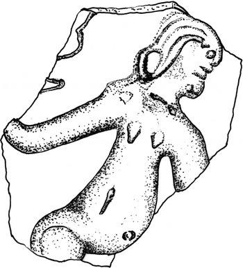
1. A sherd of LNVCC ware (fig. 26) from a beaker with barbotine decoration found in a medieval layer (41) within Trench L (see fig. 7 for trench layout). The sherd has a dark brown-grey finish on the inner and outer surfaces and the fabric is fired a cream-grey. The sherd shows a female figure leaning slightly forward with her arms extended. She has small breasts and a rounded abdomen, which has an added barbotine line drawn on her right lower side. She has a well-defined hairstyle and may be wearing a necklace. Vessels with figures have been the subject of several recent studies and appear to have been special items, possibly made to order.Footnote 121 The date range for this class of vessel, within the late second to third centuries, appears to be the same as that for other decorated barbotine beakers without figures.Footnote 122 Who or what the figure represents is uncertain. It is possible that she is shown in a dancing posture, which may be similar to other dancing figures that have been linked with the cult of Bacchus.Footnote 123 A sherd from Baldock shows a dancing maenad, while two sherds from Ashton (Northants.) each show a maenad with her arms held aloft in a dancing pose.Footnote 124 Alternatively, the rounded abdomen of the figure on the Castor sherd may indicate that she is pregnant and if this is the case, the vessel may fall into the category of Lower Nene Valley beakers which show a repertoire of fertility and erotic scenes.Footnote 125 The stylised eye, pronounced nose and swept back hair of the female on the Castor sherd match the features shown on a figure from Horsey TollFootnote 126 and it is possible that they were both made by the same potter.Footnote 127
Sherd of LNVCC ware decorated with a female figure. Scale 3:2.

2. A sherd of self-coloured ware (fig. 27) which has fired pink-light orange on the outer and orange on the inner surfaces, with an orange fabric. A brown-orange paint has been applied to the outer surface. The piece comes from a layer of medieval disturbance (46) within Trench L (1973). The sherd is part of the upper body of what appears to be a duck, a goose or even a swan with the added paint representing the plumage. The head and neck and most of the body are missing, but originally it may have been c. 150 mm long (breast to tail) and up to 50–70 mm deep. At the break near the tail there is a V-shaped cut, which was made whilst the clay was still plastic. There are indications around this cut that something may originally have been luted to the back of the bird. It is likely that the original object would have been hollow, with the potter having carefully smoothed out the clay into a thin, flat slab and then rolled it around and made a join along the top of the back of the bird, before modelling the rest of the body. Fingerprints from this modelling process can be seen on the inner and outer surfaces of the sherd. At present the item is without parallel. It may have been made as a child's toyFootnote 128 or possibly the figure may have had some religious connection. Ducks, geese and swans figure in both Celtic and Roman religious iconographyFootnote 129 and the Castor bird may have been an effigy for a lararium or shrine.
Sherd of LNVCC ware showing a fragment of an aquatic bird. Scale 1:2.

The character of the excavations and the nature of the very disturbed deposits have resulted in very few significant and stratified finds. Finds of samian, amphorae, copper-alloy objects and coins were few but have been reported on as follows:
THE SAMIAN STAMPS By Felicity C. Wild
Trench L produced three stamped samian bases (fig. 28), all datable to the late second century a.d. or after.
Samian stamps.

1. Form 31, Central Gaulish, burnt, with CΛT[VSS].Λ.M stamped across the kick, which is abraded in the centre. The wall appears to have been removed, after breakage, to perhaps form a lid. The stamp is almost certainly die 1a of Catussa of Lezoux.Footnote 130 The stamp occurs on the late Antonine forms 31R, 79 and 79/80 and at sites in the Hadrian's Wall hinterland which were reoccupied c. a.d. 160. c. a.d. 155–190. (CAS.P. 1973. Tr. L, 62; SF133)
2. Form 32, East Gaulish, with the stamp NΛTΛLISF (or perhaps FE, the F written as E without the top bar). There were several samian potters with this name, but this is likely to be the work of the Natalis who worked at Rheinzabern. Ludowici illustrates a stamp with a similar reading on a bowl of the same form.Footnote 131 Although not the same die, it is sufficiently close to be likely that it is the work of the same potter. A late second- or possibly third-century date seems likely. (CAS.P. 1973. Tr. L, 7; SF61)
3. Form 38, Central Gaulish, stamped VIC/////RI[. This is probably a stamp of Victor iv of Lezoux, who produced the late Antonine forms 31R and 79 as well as 38.Footnote 132 One of his stamps was found in a grave at Sompting, Sussex, with a little-worn coin of Geta as Caesar (a.d. 198–209).Footnote 133 c. a.d. 160–200. (CAS.P. 1973. Tr. L, 69; SF111)
AMPHORAE By David Peacock
Three sherds of amphorae were recovered during the 1970–73 excavations (not illus.).
1. Handle of Dressel 20 from the Guadalquivir Valley (southern Spain); olive oil. (Cas.P. 1970. Tr. XX, 5)
2. Sherd of Gauloise 4 from the South of France; wine. (Cas.P. 1970. Tr. XVII, +)
3. Sherd, possibly Dressel 2-4; wine (Italy/Spain?). (Cas.P. 1970. Tr. XII, 1)
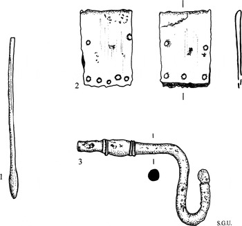
SMALL FINDS OF COPPER-ALLOY
1. Probe, broken at one end (fig. 29). (Cas.P. 1970. Tr. XXIV, 5; SF 19)
Copper-alloy small finds. Scale 1:1.

2. Copper-alloy sheet folded over with punched holes in both leaves; five in one leaf and seven in the other (fig. 29). Five of the punched holes correspond with the opposing leaf; the two remaining holes may have been for attaching the sheet to a fabric or leather strap. (Cas.P. 1971. Tr. XXVII, 13; SF 24)
3. Part of a drop handle, with decoration formed by concentric rings (fig. 29). (Cas.P.1970. Tr. XXV, 2; SF 18)
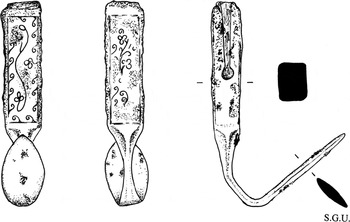
Scalpel handle (fig. 30) By Ralph Jackson
Original length c. 80 mm. Grip width c. 0.9 mm. Grip thickness c. 0.7 mm. (Cas.P. 1971, Tr. XXXII, 3; SF 25)
Copper-alloy scalpel handle. Scale 1:1.

A copper-alloy scalpel handle of standard Roman form, with a rectangular-sectioned block-like grip and a heavily-distorted spatulate blunt dissector terminal. It is a Type I scalpel handle with stout grip which incorporates the normal and distinctive ‘keyhole’ socket to secure a blade of iron or steel.Footnote 134 Although the blade is lacking, its corroded tang remains in the socket. The two principal faces of the grip are ornamented with an incised design, which comprises a stylised vine scroll motif within a wave-crest border. The blunt dissector is of short and broad form, with a strong median ridge on both faces. Considerable force would have been required to bend it (at two points on its slender faceted stem) to its present position. In view of the acute angle it is unlikely that this distortion is an example of a practitioner's adaptation of an instrument, as sometimes occurs.
Unlike spatula probes, scoop probes, ligulae and tweezers which — as general purpose toilet and cosmetic implements sometimes used in medicine and surgery — can only be considered as quasi-medical implements when found on their own, scalpels — the surgical tool par excellence — were foremost among those Roman instruments designed and made specifically for the practice of surgery. Thus, although as a single instrument the medical implications for the Castor find are limited, it is, nevertheless, a diagnostic tool of surgery and may be taken to indicate medical activity in, or near, the locality.
Decoration on Roman surgical instruments, where there was scope for it at all, was principally confined to the non-functional parts — generally grips and handles — and these limited available fields dictated to a great extent the form of decoration and the choice of motif. Thus, mouldings and finials on slender-stemmed instruments are by far and away the commonest, but a few instruments provided the opportunity for more ambitious designs. The grip of scalpel handles, especially the broader block-like grip of the Type I variety, was a favoured field for inlaid motifs. One of these, a scalpel handle from Asia Minor, has a silver- and copper-inlaid image of a bird.Footnote 135 However, the great majority (about 30 examples scattered widely throughout the Empire, though with a concentration in the Rhineland and north-east Gaul)Footnote 136 show only slightly varying versions of a stock motif: a more or less stylised sinuous vine-spray or ivy leaf tendril often enclosed in a wave-crest border. In some examples the design was incised directly into the body metal and filled with niello inlay,Footnote 137 but in other examples an embossed copper panel was soldered into a recessed space and sometimes further ornamented with silver and copper.Footnote 138 Clearly the Castor handle belongs to the former category. The ‘meaning’ of the symbolic Dionysiac/Bacchic décor of these scalpel handles is open to question, but Künzl regards it as ‘positive’ imagery, aligning it with similar motifs found on early Imperial sword scabbards, which he interprets as symbolic of the prosperity of the Empire under the protection of the virtus of the Roman army.Footnote 139 Perhaps, therefore, it was the sort of image that would have instilled confidence in a prospective patient.
The British comparanda include an unpublished example from Colchester (unusually on a Type II handle in Colchester Museum) and a fragmentary example from Gadebridge Park (a Type I handle lacking both its blade and dissector),Footnote 140 as well as a slender version, without the wave-crest border, on a Type I handle in a group of eight instruments said to have been found at Cramond Roman fort.Footnote 141
Künzl concluded that the number of these decorated scalpel handles was too small to permit speculation on common workshop products.Footnote 142 Likewise, while the Gadebridge Park and Castor handles (neither known to Künzl or Büsing-Kolbe) are similar, they are not sufficiently close to imply manufacture in the same workshop.
Dating of the type, too, is imprecise, owing both to enduring imagery and the potential for re-use of scalpel handles. Thus, while it is clear that some examples were probably made as early as the first century a.d., and production seems to have ceased by the late second century,Footnote 143 the contextual dates imply continued usage well into the third century and beyond.
THE COINS By Adrian Challands
1. Æ 3 Constantius II as Caesar a.d. 324–337. Patinated, broken, slightly worn.
Obv. FLIVLCONSTANTIVSNO[BC] Laureate and cuirassed bust, right.
Rev. GLOR[IAE]X[ERCI]TVS Two soldiers one standard.
Mint Mark • TRP • Trier. Minted a.d. 335–337. (Cas.P. Tr. VIII, +; SFN 5)
2. Æ 3 Constantinian Commemorative. Patinated and slightly worn.
Obv. [VRB]S ROMA Helmeted and cuirassed bust of Roma, left.
Rev. No legend. Wolf and twins below two stars.
Mint Mark [?PL]G Lugdunum. Minted a.d. 330–337. (Cas.P. Tr. XIV, 1; SFN 6)
3. Unofficial issue of Constantinian Commemorative. Slightly worn.
Obv. Blundered legend should be CONSTANTINOPOLIS. Helmeted bust of Constantinopolis, left.
Rev. No legend. Victory on prow.
No mint mark. A reasonably good copy, and manufactured at a probably similar date to the official issue minting, a.d. 330–337. (Cas.P. Tr. XIX, 4; SFN 9)
4. Minim c. 11.0 mm diameter. Copy of a Fel Temp Reparatio Type. Slightly worn.
Obv. No legend. Pearl diademed bust, right.
Rev. Blundered legend should be FEL TEMP REPARATIO. Copy of soldier spearing fallen horseman.
No mint mark. BoonFootnote 144 suggests a minting date of a.d. 357–367 for the small size module. (Cas.P. Tr. XXIII, 8; SFN 17)
WALL-PLASTER FROM THE PRAETORIUM
Substantial quantities of painted wall-plaster and lime and mortar rendering were recovered from almost all parts of the site during the excavations of the 1950s, 1970s and 1980s. The excavations by Green in 1957–58 on a building 50 m south of the church (see fig. 36) produced six fragments of painted plaster from Pit 1 and another 20 pieces from Rooms 1 and 2. These fragments were in white, red and brown, with some indicating a striped pattern of brown paint on a white background.Footnote 145 Green also discovered that some of the walls of the eastern wing of the North Range had in part been rendered, although there was no indication of any added colour here.Footnote 146 Similarly the excavations by Wild and Dannell during the 1970s produced large quantities of painted plaster and examples of uncoloured plaster still in situ on walls located within Trench XXXVI (see fig. 7). In-situ plaster was also found on walls in the school playing field (see fig. 36).Footnote 147 Both Rollo and Lucas reported quantities of painted plaster from their excavations in 1980 and 1998, while more recently trial-trenching in 2008, to the south-east of the village hall, produced Roman walls and more painted plaster.Footnote 148
All the painted plaster recovered in recent years has been fragmentary, none being recovered in situ or as undisturbed fallen sections. What plaster had not fallen from walls and ceilings after the buildings and rooms were abandoned or occupied during the post-Roman period, appears to have been hacked off when the site was quarried for building stone. Edmund Artis, who witnessed some of the destruction as roads were cut into the hillside to reduce the gradient of the slope, reported that ‘on the north side of the church [Roman] rooms have been discovered, the walls of which are beautifully painted and from 10 to 11 feet high’.Footnote 149 Strangely, when Artis came to illustrate the site in the series of plates published in 1828, he failed to show any of the excavated buildings with plastered walls; instead he showed the walls constructed in herringbone masonry without any plaster covering.
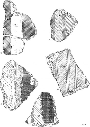
The painted plaster fragments shown in figs 31 and 32 come from rooms on the western side of the North Range and were found during the 1970–73 excavations. They represent just a small fraction of what was actually recovered, but indicate the range of colour and schemes used in the rooms of the North Range. There has been no attempt to quantify the amount of plaster, nor to try and assign decorative schemes to individual rooms. The general history of the site, and particularly the North Range, shows that post-Roman robbing and occupation has disturbed the archaeological deposits to such an extent that such data for individual rooms have been lost.
Wall-plaster showing designs or patterns. Scale 1:2.

Wall-plaster with stripes. Scale 1:2.

The painted plaster fragments which have been examined fall into three groups: (1) monochrome fragments (not illus.), forming the largest assemblage, in white, red-maroon (being most represented),Footnote 150 light blue and light green; (2) fragments which show some form of pattern or design (see fig. 31); and (3) fragments which form parts of striped decorative patterns (see fig. 32).Footnote 151 Clearly all three categories may have originally formed part of an overall scheme in a room or rooms, but it is now impossible to reconstruct such schemes.
Wall-plaster fragments with designs or patterns (fig. 31, A–D)
A. Fragment of a complicated pattern, with a dark green lozenge shape on the right over-painted on a light green background which is edged with light blue. To the left of this edging, a white background has been over-painted with a vertical (?) blue/grey line and on the extreme left of the fragment are brush strokes in pink of yet another element. (Cas.P. 1970. Tr. I, 4)
B. A dark blue background on which are painted dark green leaves, the stems of which are in cream. (Cas.P. 1970. Tr. I, 2)
C. Part of an unidentified feature painted on a dark green background. The feature is curved at the top and flattened at the bottom (as presented in the drawing) and is painted with a purple surround that merges with an orange/ochre paint. The central part of the feature is cream with pink tinges. It may represent some figurative element, with the curvature possibly representing an arm or perhaps a leg. Alternatively, it may have been part of a floral design with the central feature representing perhaps some large bell-shaped flower. (Cas.P. 1970. Tr. IA, 1)
D. Small fragment painted with a light green panel on the right, whilst the left of the piece is painted pink with a trellis-like pattern in cream. (Cas.P. 1971. Tr. XXVII, 12)
Wall-plaster fragments with stripes (fig. 32, E–I)
E. Three joining fragments which form part of a vertical (?) striped pattern or border scheme. Two stripes are in red which has a slight brownish tinge, while the central pattern is in cream. (Cas.P. 1970. Tr. XVIII, 2)
F. Small fragment of a border scheme with vertical red lines interspaced with pale yellow lines. On one of the yellow bands is a thin pink line. (Cas.P. 1970. Tr. IX, 3)
G. Fragment painted with a dark colour on the right-hand side. To the left are lines of light blue, then light green, and finally pale yellow. (Cas.P. 1971. Tr. XXIX, 4)
H. Rectangular fragment, which is painted in light blue with thin vertical (?) lines of light green. (Cas.P. 1971. Tr. XXX, 5)
I. Fragment with a dark green edge on the right and then to the left vertical (?) lines painted in first yellow, followed by lines of light green, and finally orange/ochre. (Cas.P. 1970. Tr. XVII, 7)
The fragments indicate the technique of wall painting, with a coarse backing layer of plaster being first applied to the wall, followed by a coat of finer plaster onto which the paint was laid.Footnote 152 Some fragments appear to display a degree of polishing to the final coat, prior to painting. This shows as a series of very fine curved or straight lines visible under the paint layer and was done, according to Vitruvius, in order to give the surface a much smoother and burnished finish.Footnote 153 There is evidence in some cases for redecoration over time, with several fragments showing one colour scheme which has then been over-painted with a different colour. For example, from Room 2 (see fig. 33) a fragment of plaster was recovered which was originally painted red, but had later been over-painted in green.
Reconstruction of the North Range with room numbering.

The repertoire of twelve colours from Castor is relatively extensive when compared with the ten colours reported from Stonea and a similar range of colours found during the recent exploratory excavations at Bedford Purlieus.Footnote 154 Finds of painted wall-plaster in the Lower Nene Valley have generally been limited, with few published examples. Plaster does not survive well in the plough soil and has only rarely been recovered during field-walking,Footnote 155 and little wall-plaster has been found during recent excavations. The site at Barnwell produced some plaster that may have been associated with a late third- or early fourth-century bath suite, while red and black plaster was recovered from the excavation of Roman buildings at Fineshade.Footnote 156 Probably the best known local illustration of the extensive range of colours and a decorative scheme is provided by Artis, who shows the view of a wall of a Roman bath at Normangate Field, Castor.Footnote 157 His illustration shows a wall (one assumes partly reconstructed), with two panels divided by three painted architectural columns. Each panel has a central area painted red, with a border of light blue, white and green stripes. At top and bottom of these panels is a broad orange stripe with a further scheme of brown, white and purple lines above and below the panels. The painted schemes of some of the rooms in the Castor Praetorium may have been similar to that illustrated by Artis, but others may have been even more elaborate, involving intricate geometrical elements, or incorporating foliage or possibly figurative elements.
MOSAIC AND TESSELLATED FLOORS AT THE PRAETORIUM
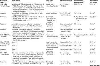
The existence of mosaic floors at the Castor Praetorium has been known for nearly 400 years.Footnote 158 Stukeley recorded seeing mosaics below the churchyard some time before 1724,Footnote 159 and just over one hundred years later in 1828, Artis published detailed drawings of three mosaics.Footnote 160 The positions of the three mosaics are shown in fig. 3, marked ‘A’ ‘E’ and ‘F’ (the mosaic floor in the room marked ‘A’ by Artis equates to Room 26 in the reconstructed arrangement of the North Range shown in fig. 33).Footnote 161 Artis also indicated on his 1828 plans of the Praetorium the positions of other mosaic or tessellated floors which he does not illustrate because they were poorly preserved. Thus in the room marked as ‘H’ (Room 22 in fig. 33), Artis refers to a ‘tessellated floor’, while in Rooms 25 and 29 he refers to ‘pavements destroyed’. The chances are that these rooms (25 and 29) would have had plain tessellated floors. Room 29 appears to have been a corridor or even a stairway and as such may not have warranted a decorative mosaic. On the other hand, Room 22 is more central to the North Range and may have formed part of a formal suite of rooms and thus warranted a decorated floor. Artis indicated in total three mosaic and three (probable) tessellated floors (see Table 1). To these can now be added six other rooms in the Praetorium complex which had tessellated floors.
DETAILS OF THE MOSAIC AND TESSELLATED PAVEMENTS KNOWN FROM THE PRAETORIUM

During the excavations carried out in 1970 by Wild and Dannell, three new tessellated floors were located in the North Range of the Praetorium in Rooms 10, 11 and 13 (figs 8, 18 and 33). It would appear that the floor in Room 13 was plain, using limestone tesserae (typically 20 × 20 × 10 mm in size). However, in Rooms 10 and 11 there may originally have been central mosaics, which had been removed with only the surrounding limestone borders in large tesserae surviving.Footnote 162 In Trench VI (figs 8 and 10) the outer, surviving limestone border (laid in 20 × 20 × 10 mm tesserae) survives with several smaller white tesserae (5 × 5 × 5 mm) abutting it, forming a remnant of the original central mosaic panel.
The 1971 excavations in the area of the Rectory garden (see figs 4 and 16) revealed an additional tessellated floor, located in Room 23 (see fig. 33). Only the edge of the floor, where it abutted a wall, was exposed in Trench LII, so it is not possible to say if it had a patterned panel in the centre or not.
The 1971 excavations also indicated that at least two rooms of the bath-house, first excavated by Artis and shown by him in pls VI and XIII, had tessellated floors.Footnote 163 Room 7 (fig. 19), which was shown by Artis to have a hypocaust, contained a broken fragment (35 by 25 cm) of tessellated floor, which was recovered from part of the robbed out area of the room (Trench XLI). This fragment clearly came from a hypocausted room for it still retained its sub-floor concrete layers. Room 8 also had a tessellated pavement. The actual floor surface of this room had been destroyed, but the impressions of large tesserae on the surviving concrete sub-floor (see fig. 21) indicate that it had been tessellated.
To these accounts of tessellated flooring can be added the likelihood of similar floors in the bath-house excavated by Green in 1957–58. No intact floors were found, but tessellated floor fragments were recovered from the building.Footnote 164 The excavations by Green on the so-called ‘Temple’ site, which formed the east wing of the North Range of the Praetorium also produced quantities of large limestone tesserae, but were not reported in the 1986 publication.
Additional finds of tesserae also came from the 1988 excavation by Lucas to the south of the church; from an evaluation trench against the wall of Castor Primary School dug in 2001; and from archaeological watching-briefs and limited excavations in 2006 to the south of the former A47 road, close to where Artis indicated other Roman buildings.Footnote 165 In all cases it would seem likely that the finds come from floors yet to be located.
THE CASTOR TESSERAE By Jackie Hall
Loose tesserae were recovered from almost all excavation trenches dug during the last 40 years, as well as being observed in situ within surviving areas of flooring. A representative sample of tesserae has been examined in order to make some preliminary comments on the possible geological sources of the stone.
1. Black-grey (size 10 × 10 × 10 mm), jet from Yorkshire or the south coast area. (Cas.P. Tr. XXI, 2)
2. White (size 16 × 15 × 15 mm), fine grained limestone; chalk; nearest source from Norfolk or Lincolnshire Wolds. (Cas.P. Tr. XXIX, 6)
3. White (size 10 × 10 × 10 mm), fine grained limestone; chalk; nearest source from Norfolk or Lincolnshire Wolds. (Cas.P. Tr. X, 2)
4. Red-orange with cream inclusions (size 8 × 8 × 8 mm), very fine grained limestone; possibly an imported marble? (Cas.P. Tr. I, 9)
5. Cut down from ceramic red tile (size 12 × 11 × 10 mm). (Cas.P. Tr. XVI, 3)
6. Buff weathered to grey (size 20 × 20 × 20 mm), medium grained calcareous sandstone; source unknown but possibly from the Midlands. (Cas.P. Tr. XXVII, 48)
7. As No. 6 above (size 10 × 10 × 10 mm). (Cas.P. Tr. XVI, 4)
8. Pale pinkish grey (8 × 8 × 8 mm), fine grained limestone; source uncertain. (Cas.P. Tr. XVI, 2)
9. Dark greyish pink (20 × 20 × 20 mm), medium grained calcareous sandstone. Same as No. 6 above, but different colour. Perhaps part of a bed containing slightly more iron staining. (Cas.P. Tr.I, 3)
In general terms there appear to be four different sizes of tesserae, each with an average size range of: (1) 20 × 20 × 20 mm;Footnote 166 (2) 15 × 15 × 15 mm; (3) 10 × 10 × 10 mm; (4) 8 × 8 × 8 mm. The largest size range is exclusively of sandstone, which had been used to form either monochrome areas of coarse flooring or to create the borders of polychrome mosaics which utilise smaller tesserae.
The wide range of possible sources of stone used at Castor is interesting and indicates the distances from which mosaic workers drew their raw materials. Possible sources from the south coast and Yorkshire, as well as the tesserae from Norfolk, illustrate this point. Local sources of limestone seem to have been ignored for the large tesserae, which dominate numerically, and preference was given to calcareous sandstones, the nearest beds of which are located at Duston and Moulton in Northamptonshire, some 50 km away.Footnote 167
During the 1957–58 excavations twelve glass tesserae — three green and nine blue — were recovered.Footnote 168 Four more blue tesserae (each 4 × 4 × 4 mm) were found in 1970 in disturbed deposits over the rooms of the North Range. Glass tesserae were rarely used in Britain, most notably at Aldborough, Cirencester and Verulamium, where they highlighted features within mosaic designs.Footnote 169 The implication of the glass tesserae from Castor is that some of the mosaics, either on the floors or as wall decoration, were particularly elaborate.
Considering the number of known rooms which had some form of tessellated flooring, and the likelihood of other tessellated floors yet to be discovered, the enormity of the flooring enterprise at the Praetorium becomes apparent. Artis was of the opinion that Room 18 (fig. 33) was entirely tessellated and illustrates a fragment of the mosaic from this room.Footnote 170 If he is right in his assumption that this room was one single tessellated space, then the overall area equates to 165 m2,Footnote 171 and the sheer quantity of tesserae needed to cover such an area would have been enormous.Footnote 172 The total tessellated area, from the known pavements at the Praetorium, is approximately 561.15 m2 (Table 1) and it is possible that this represents only about half of what would have been tessellated in the complex. More tessellated floors and mosaics could certainly be expected in the North Range, especially in the central area which one would assume provided a more formal space and where a show of opulence may have been required. The general distribution of tesserae over the site would certainly support the idea that more floors await discovery, while others have already probably been destroyed.Footnote 173
All the known decorative mosaic floors at Castor have been dated to the late third or fourth century, based on their designs as shown by Artis.Footnote 174 No others have been found or dated in modern excavations and little can be added to refine this range. There are clear examples of concrete floors being re-laid in Rooms 10 (figs 8, 9 and 33) and 31 (figs 8, 11 (Trench XVII) and 33). Certainly in Room 10 the replacement floor had a border of large limestone tesserae and a decorative central mosaic, which had subsequently been removed. The pottery from between the two floors (fig. 23) provided a date range from the late third to early fourth centuries and thus matched the suggested date range for the mosaics given by Neal and Cosh. It is uncertain if the earlier floors in both these rooms had any tessellation, but quantities of limestone tesserae (20 × 20 × 20 mm) were recovered from under the later floor level of Room 10 and may indicate that this earlier floor, which could date to the late first or early second quarter of the third century, was provided with some form of pavement.Footnote 175
MARBLE VENEER
During the 1980 excavations in the garden of ‘Elmlea House’, a single broken fragment of cut and polished veneer, possibly of ‘Alwalton Marble’Footnote 176 was recovered from Trench 3 (see fig. 7).Footnote 177 A similar piece of veneer was recovered during archaeological evaluation work in 2008 to the south of the former A47 road, near the village hall (see figs 4 and 36).Footnote 178 Both fragments are 10 mm thick and show no sign of wear. It is unclear if they were used either as part of floor tiling or, perhaps more likely because of the lack of any wear, as a wall covering (opus sectile).Footnote 179 Artis clearly found evidence of ‘Alwalton Marble’ veneers being used in some of the buildings of Durobrivae and he shows a schematic view of how they were applied to walls.Footnote 180
There is only limited evidence from Roman Britain for the use of marble veneers and they are best represented at Fishbourne.Footnote 181 The closest known site to Castor that has produced stone veneer is Piddington Roman villa in Northamptonshire.Footnote 182
Both the Castor fragments come from unsealed deposits so cannot be securely dated. However, the opulence of the general building programme at Castor, especially the rooms which form the North Range, and the presence of tessellated flooring, would make the use of opus sectile very likely.
HEATING AND THE HYPOCAUSTS WITHIN THE PRAETORIUM BUILDINGS
There are several hypocaust systems which were found either by Artis or during more recent excavations. Artis shows three rooms in the eastern wing of the North Range which were heated.Footnote 183 One of these (Room 28; see figs 18 and 33) had a channelled hypocaust, but it is unclear from Artis' drawing where it was heated from, unless the hot air was drawn from the adjoining Room 24, which in turn may have been heated by a furnace on its north side. There is little indication as to the way Room 24 was heated. Artis simply shows two piers in the south-east corner and comments ‘… Some of the piers intended to support the floor above’. He provides even less information about Room 23, where he simply shows three pilae against the north wall. This provides a problem of interpretation since Wild's later excavations conducted in this room (Trench LII; fig. 16) provided evidence for a tessellated floor, which seemed to be laid on a solid foundation and not on a raised hypocaust floor.
Three other rooms, (1, 2 and 3) in the west wing of the North Range were also heated by a hypocaust system. None of the pilae from these floors remained in situ, but the concrete sub-floors on which they would have been built and the linking openings which would have ducted the hot air through the walls and between the rooms were located (see fig. 13). The opening between Rooms 2Footnote 184 and 3 is interesting in that in its first phase it was built out of tile as a simple aperture in the width of the wall. At some later point an additional tile extension, with a slight splay at its southern end, was constructed projecting some 0.9 m into Room 2. A similar extension to the flue arrangement between Rooms 24 and 28 can be seen in the Artis plan of these rooms (figs 16 and 33). The lengthening of the flues may have been undertaken to create a sufficient draft for the heating system, and to help with the ducting of the hot gasses up the walls through box-tiles.Footnote 185 No box-tiles were found in situ, but the seating for one tile was found set into the north wall of Room 2. If this explanation for the flue extension in Room 2 is correct, then it implies that Rooms 1, 2 and 3 were stoked from the north side. The exact position of the north wall of Room 3 has yet to be found, but beyond its probable line a large pit-like feature, containing quantities of early and middle Saxon material, was excavated in 1973 by Dallas (Trench L; see figs 7 and 13).Footnote 186 It seems very likely that this pit, which probably abutted the outside of the north wall of Room 3 could have been the original stoke-hole for the furnace to heat these rooms.Footnote 187
Since the façade of the Praetorium would have been designed to impress those viewing the site, it would make perfect sense for all the stoking areas of the heating systems to be located out of sight on the north side of the structure. However, the slope of the ground to the south and the prevailing wind direction from the south-west may have posed some problems in heating the rooms from the north and again this may in part at least provide an explanation for the channelled extensions in Rooms 2 and 28, which would have improved the draught and thus heat circulation. The slope of the ground may also have imposed some limitations on which rooms in the North Range could be heated, since hypocausts required raised floor levels. This could account for the need for a flight of steps, shown by Artis, leading up from Room 26 into 24, which had a hypocaust (shown in figs 16, 18 and 33). There are no other known hypocausts elsewhere in the North Range, and the remaining rooms must have used braziers or fireplaces during cold weather.
Only two other heated rooms — beside those in the bath-house described by Artis — are known in the other buildings at the Praetorium away from the North Range. Green found a room with a hypocaust in his excavations in 1957–58 and more recently another hypocaust was found to the south of the former A47 road in the ‘Castor Barns’ area (see figs 4 and 36).Footnote 188 However, vast quantities of box-tile have been found across the whole site of the Praetorium, which suggests that more heated rooms await discovery.
INTERPRETATION OF THE NORTH RANGE
The plan of the North Range of rooms shown in fig. 18 has incorporated all the known evidence from excavations and early accounts of the site, especially that recorded by Artis. The overall view is that of a balanced, architectural arrangement with a central range of rooms which ran across the crest of the slope and with wings to the east and west which extended to the south. Excavations over the last 40 years have determined the positions of the rooms shown by Artis and also exposed newly discovered walls. The biggest problem, however, remains in trying to fit all of the rooms of the North Range shown by Artis into a coherent plan that might make architectural sense. For example, in the case of Room ‘F’ (fig. 3), which contained a mosaic floor, lying just to the north of the church, even Artis' drawing shows that there is a problem, with the room appearing to be isolated and also slightly out of alignment with the other rooms which he shows to the north-east. This may just be a problem with the small scale of his drawings and the intervals between his recordings of the separate elements which make up the North Range. However, it poses problems for any modern interpretation of the site as a whole.Footnote 189 The best solution adopted here has been to shift the position of Room ‘F’ slightly to the north-east and twist its orientation so that it lines up with the other rooms, thereby forming a more cohesive central element to the whole of the North Range.Footnote 190 This arrangement can be seen in fig. 33,Footnote 191 where all of the spaces in the North Range have been numbered and where the confirmed walls are shown in solid black.Footnote 192 The less precisely located walls indicated by Artis on his general plan of the whole village are also shown in fig. 33,Footnote 193 along with walls which are conjectured.Footnote 194
This approach to reconstructing the plan from our present state of knowledge gives an overall architectural impression of the North Range; this appears to show a unified design with east and west wings and a central area containing what were most probably the principal reception rooms.Footnote 195
THE WEST WING OF THE NORTH RANGE
Rooms 4–7 are those shown by Artis in his pl. II (fig. 6), as well as his pl. XI, 1. He shows doorways linking rooms and another leading to the outside frontage to the south of the North Range; one of these doorways even seems to exhibit a chamfered door jamb.Footnote 196 The walls in this illustrated view are typically of undressed limestone set in herringbone fashion, with larger quoin stones at the corners. Artis also shows a curious feature in the end wall of Room 7, which may be interpreted as a blocked-in window or the slots may perhaps once have held timber framing set into the wall line.
To the west of this area, Artis shows (fig. 3) more rooms, but with less detail. The long room extending to the south which forms Room 2 (fig. 33) is connected by hypocaust channels through its north wall to Room 3, which in turn is linked to Room 1 by yet another flue channel. The large pit found by Dallas in 1973 lies to the north of Room 3 and, although the north wall of this room is still to be located, the pit may have formed the stoking pit for the hypocausts in this part of the building (see above).Footnote 197 Room 2 in its present form, which is entirely based on Artis' drawing, is a very large space, measuring 4.5 by 26 m, but it may have been subdivided into smaller units. The southern, short axis wall of this room is shown in fig. 34,Footnote 198 and is discussed below in connection with Room 30.
The remaining block of rooms on the western side of the North Range comprises those which have been found during the excavations in the 1970s (Rooms 9–13) and those which are conjectured (Rooms 8, 12 and 15) and which mirror Artis' room outline on the eastern side of the building.
North Range: south wall of Room 2 showing offset. Scales in units of 10 and 50 cm. (Photo: S.G.Upex)

THE EAST WING OF THE NORTH RANGE
Artis shows a view of part of this eastern set of rooms in his pl. X, which includes Rooms 24, 26, 28 and 29, and they are also partly shown in plan in his pl. XIII. Room 28 is the only room in the whole of the North Range where he shows the detail of a channelled hypocaust, although he indicates that other rooms were heated (by pillared hypocausts), without showing any detail, which may be owing to their poor preservation when excavated.
Room 25, which Artis describes as originally having a pavement, appears to mirror Room 4 and part of Room 7 on the western side of the building. Rooms 26, 27, 29 and 30 all appear to form a wing extending to the south and match the west wing formed by Room 2. On the south side of Room 24, Artis shows a break in the wall line and indicates steps leading down into Room 26. Such steps between the two rooms would have been required first to allow for the fact that Room 24 possibly had a hypocaust and secondly to compensate for the general slope of the ground. Room 29 is a narrow tessellated passage which may have led from Room 24 and connected Rooms 26, 27 and 30.
To the north of these rooms, the arrangement shown by Artis (Rooms 19–22) mirrors the plan on the western side of the North Range.
ROOM 30: INTERPRETED BY ARTIS AS A ‘CLASSICAL TEMPLE’
Room 30 is the only space within the entire North Range to which Artis assigned a function. He states on his plan and section of the room (pl. XI, 2; see fig. 16), ‘Plan of a Temple?’. He saw the room as having three elements to it; firstly steps on the south side leading up to a flat area representing perhaps the portico and entrance to a temple and then a large step down into a square area, which his plan indicates was ‘30 feet square’ (9.15 m). Artis thought that the ‘Temple’ was connected by walls to Rooms 27 and 29 to the north, with 29 perhaps acting as some form of passage to link the areas together. He shows this integration of the rooms clearly in his overall plan of the Roman buildings around the church (pl. XIII; fig. 3), where he labels part of the ‘temple room’ as ‘C’. This view of the unified aspect of the ‘Temple’ with the rooms to the north was tested further during 1957–58 by Green, who re-excavated part of this area in advance of an extension to the graveyard.Footnote 199 Green located the ‘front steps’ and platform to the south of Room 30, but in trenching to the north of the room he found no evidence of linking walls to unify the temple with the remaining parts of the east wing.Footnote 200 M.J.T. Lewis carried out a reappraisal of both the site and Green's excavation notes in the 1960s and came to the opinion that the site was indeed a temple with a ‘row of prostyle columns’ at the south front, but agreed with Green that it was separate from the other buildings of the North Range.Footnote 201
Several points emerge from a review of the evidence for the ‘temple room’. The first is that Artis' dimensions appear to be slightly out.Footnote 202 In addition, although both Green and Lewis argue for the ‘temple room’ to be free-standing, the wall alignments of Rooms 27 and 29 match the alignments of the ‘temple walls’ exactly and there must be a strong case to argue for the rooms on this east side of the North Range being unified and linked together.Footnote 203 In addition, Artis' plan shows a further problem if the main space of Room 30 is to be seen as the cella of a temple. He shows in the centre of his ‘30 feet square’ room a small 3 foot square (0.914 m) raised area of masonry on the floor. In this position, it is unlikely to have been the base for an altar. Mackreth has suggested that the feature was the base of a stone support for a floor above the room,Footnote 204 but how this interpretation fits with the notion of a temple cella is unclear.Footnote 205
Excavations by Time Team in 2010 on the western wing of the North Range revealed that the south wall of Room 2 was a massive 1.50 m wide with an additional 0.5 m wide offset. This width of masonry was clearly part wall foundation, but also must have acted as a revetment to retain the natural slope on which the building sat.Footnote 206 The offset in the masonry, shown in fig. 34, is step-like and matches that found in the east wing of the North Range by both Artis and Green, who there thought that it was part of a flight of steps. Green published a photograph of his ‘temple steps’,Footnote 207 which show a remarkably similar offset to that found in the west wing. Thus the ‘temple steps’ are now better seen as a structural offset for a revetment, a feature which occurs in both the west and east wings, adding further weight to the idea that there was an intended architectural unity to large parts of the North Range.
Room 30 is, therefore, unlikely to represent a classical temple and is more probably part of a range of rooms which balance the intended visual appearance of the North Range.
THE CENTRAL ROOMS OF THE NORTH RANGE
The central area of the North Range remains the preserve of Artis, who is the only person to have made any record of it. A ground penetrating radar survey undertaken during the 2010 Time Team investigations failed to record any features that resembled walls, perhaps owing to the very disturbed nature of the ground,Footnote 208 even though Roman rooms are known to exist in the area (for example, Room 18; see below). In fig. 33, Room 18 has been moved to the north-east from the position where Artis appears to indicate it (see figs 3 and 18) and other rooms (16, 17, and 19) have also been adjusted to produce a ‘best fit’ plan and one that ties them in to the location of recently excavated and surveyed walls. The overall view of these central rooms is, therefore, one of a tripartite arrangement, with Room 18 leading into 17 and on into 16, with Rooms 15 and 19 flanking on either side. Again, caution is needed in visualising the rooms shown in fig. 33, for some could well have been further subdivided into smaller units, in the same way as possibly Room 2 in the west wing. However, since our only knowledge of these rooms comes from Artis and their remains have either been quarried away by road works in the 1820s or are inaccessible in the churchyard, the prospect of further information regarding this part of the complex looks remote.
Room 18 was explored during 2010 in a 0.5 m-wide trench cut to the north of the church within the churchyard as part of the Time Team investigation. No walls were encountered, but the mosaic floor recorded by Artis in 1827 was found with later burials set both on the pavement and cutting through it (figs 18 and 35).Footnote 209
North Range: burials laid on the tessellated floor of Room 18. (Photo: S.G.Upex)

What little can be said with certainty, therefore, is that Room 18, which measures c. 22 by 7.5 m (165 m2)Footnote 210 is clearly central to the whole of the North Range and had a polychrome mosaic. Behind this, Room 17 measures c. 22 by 16.5 m (363 m2) and Room 16 approximately 22 by 12 m (264 m2). As with most of the detail from the North Range, apart from Rooms 6 and 7, there is no information available to suggest entrances or doorways, but one might assume that Room 18 had some form of formal entrance on its south side.
THE LAYOUT AND POSSIBLE FUNCTION OF ROOMS IN THE NORTH RANGE
The tripartite layout of rooms in the central area of the North Range is seemingly rare at villas in Britain.Footnote 211 It might imply a highly formalised arrangement, where perhaps high-ranking visitors would have entered the building through Room 18 and ultimately progressed to Room 16. The arrangements seen in some British villa plans also suggest a formal approach to the organisation of reception rooms.Footnote 212 At Bignor (Sussex) an arrangement of rooms in the corner of the north range has been interpreted as a basilica/audience area and similar sets of corner rooms are known at North Leigh (Oxon.) and Box (Wilts.).Footnote 213 At Spoonley Wood (Glos.) the later phase of the courtyard villa had a central reception room behind which was a triclinium, while the formal central layout at Lullingstone (Kent) is also presumably meant to receive and entertain guests.Footnote 214 However, the scale of the rooms at these sites is small compared with that at Castor. Establishments with larger rooms, such as Woodchester and Fishbourne, are worth consideration in a search for parallels, both in room size and architectural layout. Woodchester, has a great room 15 m2 (Room 1),Footnote 215 which appears to form the main reception room, preceded by an inner courtyard and before that a large block of rooms, two of which (Rooms 25 and 26) J.T. Smith considered to have been ‘in the nature of an audience hall or antechamber … (and) … a justice room’.Footnote 216 At Fishbourne an even more formal arrangement seems to have operated with a large entrance hall, which contained side offices and a fountain, forming the first architectural element through which visitors were led into a peristyle courtyard garden, on the far side of which was an audience chamber.Footnote 217
The size and area of the various central rooms in the North Range at Castor and other villa sites are summarised in Table 2.Footnote 218 Clearly any direct comparison between sites is fraught with danger, including assigning an accurate function to each of the rooms under review (as well as the poor understanding which we currently have regarding any subdivision of the rooms at Castor). However, details of the six sites in Table 2 reveal one or two interesting points that are worthy of comment. The first is the comparison between the entrance areas at Castor and Woodchester. The three rooms at Woodchester (Rooms 25–27), which appear to provide an entrance from the central courtyard to the inner courtyard, are all exceptionally large and may all have been connected by doors. Smith concludes that they served some public function.Footnote 219 Individually these three rooms are similar in size to the possible entrance hall at Castor (Room 18). Turning to the central areas, the corresponding space at Woodchester is much larger than that at Castor (Room 17), while the garden at Fishbourne dwarfs both of them. However problematic the interpretation,Footnote 220 the third room at Castor (Room 16, termed ‘audience room’ in Table 2) compares very favourably with Room 1 at Woodchester and is twice as large as the so-called ‘audience hall’ at Fishbourne. Comparison with other sites — e.g. the ‘Venus Mosaic Room’ at Bignor, the ‘Dining Room’ at Chedworth, and the ‘Central Hall’ at continental examples such as Nennig (Germany) — shows that the Castor rooms were much larger. What becomes clear from this brief comparison is that the Castor rooms in the central area of the North Range seem to be exceptional on current evidence and challenge the view that Room 1 at Woodchester is the largest room known in a Romano-British residential building.Footnote 221
A COMPARISON OF SPECIFIC ROOM SIZES
(Castor Praetorium; Woodchester (Clarke Reference Clarke1982, fig. 1); Fishbourne (Cunliffe Reference Cunliffe1971a, figs 23, 32, 38 and 42); Bignor (Winbolt and Herbert Reference Winbolt and Herbert1963, plan; Frere Reference Frere1982, fig. 2); Chedworth (Goodburn Reference Goodburn1972, 28); Nennig (Wightman Reference Wightman1970, fig. 16))

If Rooms 16 and 18 at Castor were indeed single areas without any divisions then the problem of roofing becomes relevant. Room 16, which is the wider of the two at 12 m is nearing the limit of what has, in the past, been assumed to be the lengths of readily available timber in the Roman Nene Valley. However, a bigger problem would have been the roofing arrangements for Room 17, which is 16.5 m wide. If this area were indeed roofed it may well have had an arrangement similar to that which has been suggested at Woodchester, with a vaulted or domed roof supported by columns.Footnote 222 The rectangular shape of Room 17 at Castor might, however, exclude the possibility of a dome. An alternative view would be to see the area as being partly open in the form of a true peristyle.Footnote 223 The advantage of this arrangement, apart from solving the problem of how the area was roofed, would have been to let light into the central area of the North Range and give access to the rooms in the east and west wings of the range. It should be stressed, however, that much of the above is speculation.
The problems of roofing, light and access, highlighted above, also emerge when considering both the east and west wings of the North Range. The rooms on both sides of the central range seem to be mirror images, but it is difficult on present evidence to determine the means of access into these areas from the many options that are possible. It would make sense to see Rooms 12 and 22 as additional peristyle garden areas, which would have given access to what are clearly a number of small rooms (8, 10, 11 and 13) in the west wing. A similar arrangement may have existed on the eastern side, although our knowledge of the rooms here is poor. Both Rooms 12 and 22 are L-shaped in form and this arrangement could suggest a series of steps, set within the narrow recessed corners, which would have led up to the rooms in the rear of the building; the contours of the ground support the need for flights of steps from the front of the building to the rear.Footnote 224 The large Rooms 15 and 19, which are sandwiched between the central rooms and the east and west wings, may have given a flexibility of access into and around Room 16 and to the rear of the structure.
Rooms 1–3 in the west wing were clearly heated and likewise Rooms 23, 24 and 28 in the east wing and this arrangement provides some element of an architectural balance across the whole building range, especially with the projecting heated Rooms 1 and 28 at either end. Room 31 is entirely conjectural and is based on the broad spread of concrete flooring which was found at the western end of this area (see figs 8 and 18). If it is assumed that Room 30 (Artis' ‘Temple’) was joined to the eastern range, then Room 29 could be seen as an access passage between this and the rooms to its north. The function of these rooms in both the east and west wings remains largely speculation. They may have served as domestic and living quarters and/or had some more specific, perhaps even official, functions which the overall character of the architecture of the North Range might suggest.
If the conjectured plan shown in fig. 33 is accepted as a basic statement of the overall layout of the North Range, then it is possible to see architectural elements in the way the rooms are set out. For example, there appear to be opposing ‘blocks’ of rooms in the west and east wings — that in the west comprising Rooms 3–8 and that in the east Rooms 23–25 and part of 26 — and although the two ‘blocks’ are not exactly the same length (east = 27 m and west = 23 m), they are the same width (14 m).
One point of interest, to which we will return, is that the North Range seems, in our present understanding of its layout, to lack baths. The rooms with hypocausts in both the west and east wings do not appear to form any suitable bathing arrangement. Also, channelled hypocausts, such as that found in Room 28, are more often associated with heated living rooms than baths. If baths were located in the North Range, one might expect them to be in the north-east area of the building, which would have been down-wind of the main complex and, therefore, would have reduced any problems with smoke pollution, as well as being suitably placed to receive water via some form of channelling from springs which occur to the north.
THE INTERPRETATION OF THE ROMAN BUILDINGS TO THE SOUTH OF THE NORTH RANGE
Our main source of detail about the buildings to the south of the North Range (see fig. 36) and at the foot of the slope comes again from the work of Artis and his published plan of 1828.Footnote 225
A plan of the known Roman remains at Castor Praetorium.

‘THE CEDARS’
In the garden of and partly underneath the house called ‘The Cedars’, Artis shows an L-shaped building, including a room marked as ‘E’ on his plan, which contained the mosaic he removed to the dairy at Milton;Footnote 226 but little else is known of this set of rooms. Excavations in 1902 by William Le Queux who owned ‘The Cedars’Footnote 227 appear to have found ‘a bath floor in excellent condition’, though it is not clear exactly where this was.Footnote 228
North-east of ‘The Cedars’, another series of walls was found in 1998 by Lucas,Footnote 229 while to the south of the property Artis shows yet another unnumbered building, apparently divided into two rooms (see fig. 36). Nothing is known of this structure, but it may be that mentioned by Le Queux in 1902. Artis may have shown part of his excavation of this building in his pl. V of The Durobrivae (see fig. 5, behind the resting workman).
ROMAN BUILDINGS TO THE SOUTH OF THE FORMER A47 ROAD
Artis shows two buildings to the south of the former A47 road. One, an L-shaped structure which he shows divided into two rooms and the other, a smaller single-roomed structure (see fig. 36).Footnote 230 Again, little more is known of these structures other than what is represented on his plan.
However, a series of watching-briefs and an excavation prior to the conversion to housing of the early eighteenth-/nineteenth-century barns,Footnote 231 shown by Artis on his plan of this area (see fig. 3), have revealed details of other, previously unknown Roman buildings. Work by Archaeological Project Services (APS) in 2006 revealed occupation material in a series of small trial pits some 30 m to the north of the L-shaped structure.Footnote 232 Further work in 2007 by APS immediately to the north of the same Roman structure uncovered details of a room with a hypocaust, wall lines and paved areas.Footnote 233 It has been suggested by Dr Ben Robinson that some of the rooms in this complex had been exposed before, with the overall impression that such work could have been that of Artis. If he had been excavating here one might presume that it was after 1828, otherwise he would have recorded the detail on his plan of that date.Footnote 234
Artis also shows another small structure (c. 14 by 8 m; see figs 3 and 36) some 100 m north-east of his L-shaped structure, and some 15 m south of the present line of the former A47 road. Nothing more is known of this structure.
ROMAN BUILDINGS IMMEDIATELY TO THE NORTH OF THE FORMER A47 ROAD
A structure c. 7 by 20 m was recorded by Artis to the east of the bath-house (see fig. 36), but nothing is known of its details other than its outline which was located by a proton magnetometer survey in the school playing field in 1971.Footnote 235 East of this building(s) another smaller structure (7 by 9 m) is again shown by Artis. This building lies partly underneath existing buildings, including ‘The Royal Oak’ public house, and apart from being recorded on Artis' plan nothing more is known.
ROMAN BUILDINGS UNDERNEATH THE SCHOOL PLAYING FIELD AND THE PRIMARY SCHOOL
During 2000 and again during 2010 resistivity surveys were carried out in the area of the school playing field, which revealed linear features.Footnote 236 The features detected in the earlier survey were tested in 2000 by two small trenches and were shown to be wall lines.Footnote 237 The indications are that readings from these surveys represent a Roman building, orientated roughly in the same direction as the other Praetorium buildings (see fig. 36) and running between the building shown by Artis just to the north of the former A47 and that excavated by Green in 1957–58.Footnote 238 If all these detected linear features are Roman walls then the building is substantial, being some 38 m long and 20 m wide. The parallel walls on the western side may form a corridor, but the rest of the room arrangements and the function of the structure remain uncertain and await further excavation.
North-east of this structure, other buildings or rooms were detected by resistivity survey in the area of the modern primary school. These remains have been recorded at various times,Footnote 239 some during building work undertaken at the school, and the Roman material that came to light included concrete and mortar floors. Once again it is difficult to know what such material represents and since most of the area is sealed below the school building there is little chance of more details emerging.
THE ROMAN BUILDINGS EXCAVATED IN 1957–58
The excavation of a building at the base of the slope below the church in 1957–58 by Charles and Ida Green was fully published in 1987.Footnote 240 The Greens found a building orientated roughly on the same line as the North Range and the other buildings in the Praetorium complex. The building was 6.5 m wide and at least 11.5 m long, but the walls ran beyond the excavated area on the north side of the trench. There were at least five rooms, including one with a hypocaust and another provided with a concrete-lined tank. This gave the Greens the impression that at least part of the structure had functioned as a bath-house. This suggestion is reinforced by the existence of a small tile-lined aqueduct, which led down the slope on the north side of the building and which could have fed a bath-house.
In 1970 a limited geophysical survey was carried out by Adrian Challands in the area between where the walls ran beyond the excavation on the north side and where the ground started to rise slightly up to the level of the medieval church (see fig. 36). This survey also extended to the west and fills in the gap between the building found by the Greens and that revealed by Lucas in 1998.Footnote 241 The results from this survey were limited by several factors, including the close proximity of wire fences, recent graves and also the spacing between the readings. However, enough data were gathered to suggest that there were yet more buildings or rooms in this area and that they appeared to fill the gap between the possible bath-house and the structure found by Lucas.Footnote 242 An additional indication of rooms within the survey area comes from a section observed during the digging of a grave in 2008. The grave clearly cut through an opus signinum floor sitting over a base layer of limestone fragments.Footnote 243 A Time Team trench cut in 2010 to the south-east of this bath-house failed to locate any wall lines, indicating that there was no link between the baths and other buildings recorded by Hatton (Reference Hatton2001) to the east.
THE BATH-HOUSE FOUND BY ARTIS
A summary of the layout of the baths found by Artis — later investigated by Wild and Dannell in 1971Footnote 244 — has already been given above. Questions still remain regarding the association of these baths with other buildings or rooms on the lower part of the site and how the baths functioned within the Praetorium complex.
Isolated baths are known in villa complexes and the distance one had to walk to bathe may have been a reflection of the status of the owner.Footnote 245 However, the evidence at Castor seems to indicate that the baths, although not necessarily joined to other rooms, were apparently surrounded by other buildings,Footnote 246 and it is necessary, therefore, to keep an open mind on just how the baths relate to other structures.Footnote 247 The baths as shown in the plan and drawing provided by Artis (see figs 19 and 36) would have provided a large and elaborate bathing establishment compared with other local villas.Footnote 248 Their layout and the regularity of plan also seem out of character with other local baths, even allowing for various possible additions to an original set of rooms.Footnote 249 The contrast in size is shown in fig. 37, where the areas of local villa baths are shown (in square metres) in comparison with that at Castor.Footnote 250 fig. 37 also includes other villa bath suites in Southern Britain where the overall areas could be measured. This clearly shows that, apart from the baths in the south-eastern part of the courtyard at Bignor (Sussex), the Castor baths are considerably larger than those at Dicket Mead (Herts.), Gadebridge Park (Herts.), and North Leigh (period 1) (Oxon.).Footnote 251 In fact the size of the Castor bath-house is more in the range of those from military contexts; for comparison, see fig. 37 which shows the areas of five military bath-houses from the North.Footnote 252
Graph showing the comparative areas of selected bath-houses.

The plan and layout of the baths also seems to follow Roman measurements based on a modular system of design.Footnote 253 fig. 38 shows the Castor baths with circular modules of 7.4 m (which equate to circles of 25 Roman pedes, or 10 Roman gradii). This shows that the overall length of the building, through Rooms 1–3, 7 and 8, is close to 100 pedes (97 m), with a width through Rooms 1 and 2 of 25 pedes. Allowing for discrepancies in the modern reconstruction of the building, the western walls of Rooms 4 and 8 also conform fairly closely to this overall modular pattern, as does the east–west centre-line through Rooms 8 and 9. Although there are problems in providing an accurate plan of the baths at Castor,Footnote 254 the likely modular layout of the whole building does suggest that it was carefully planned, in a way that contrasts with the rather haphazard planning of other local villa baths. Such planning of buildings on public and especially military sites is not uncommon,Footnote 255 and it does beg the question as to whom was responsible for the planning at Castor. Was it simply a local architect, or do the size, design and the modular layout of the baths suggest an architect associated more with public or even military structures?
Castor Praetorium: Artis' bath-house with modules of 25 pedes superimposed on the plan.

This leads to the problem of how the baths functioned within the whole complex and here the question of dating is significant. The 1971 and 2010 investigations of the baths produced no stratified pottery. However, the general assemblage of material comprised a predominance of second- and early third-century local wares, with surprisingly few pieces from the late third and early fourth centuries.Footnote 256 This situation also appears to have been paralleled at the bath-house discovered by Green in 1957–58, who concluded that the structure had been demolished by the third century.Footnote 257 What is indicated from the limited evidence is that Artis' bath-house may similarly not have operated from the late third century and may have been at least partly demolished at the same time as the bath-house uncovered by Green: the significance of the dating of this part of the site in relation to the rest of the Praetorium will be returned to below.Footnote 258
THE TOPOGRAPHY AND LANDSCAPE SETTING OF THE PRAETORIUM
The whole site which Artis originally described as the Praetorium was built on two distinct levels, a lower, level area below the site of the medieval church and an upper area on which the Roman North Range and later the medieval church were sited. The difference in height from roughly north to south across the ranges of Roman rooms is 13.7 m; this can be seen in a contour survey carried out in 2007 (fig. 39).Footnote 259 This survey highlights the deep inroads into the site which the grading down of the road surfaces made in the nineteenth century, especially over the western and eastern wings of the North Range.Footnote 260
Contour survey of the whole of the Praetorium area.

The Roman buildings of the Praetorium were arranged in two discrete groups — an arrangement which may be more apparent than real today, given our still limited knowledge of the site. The North Range is set out across the top of a slope, which is formed by a natural terrace of the River Nene. This building range, which appears to form one coherent block, perhaps of several different building phases, is set out so that the central area has a levelled surface in front of it (on which the medieval church was later built). The ground at the back of the North Range is just above 22 m AOD, while that at the front of the central area of the range is at 18.5 m AOD. This drop of 3.5 m across the width of this building (which at this point is c. 48 m) would have posed problems for the builders in terms of rooms having different floor levels and also in roofing the structure. On either side of this central block the east and west wings extended southwards to the very edge of the sloping ground. The wing on the east side appears to have been built where the natural slope of the ground also swings round to the north, so that originally the ground would have sloped steeply on its south (front) and east sides.Footnote 261 To the south of the site, other Roman buildings are set out at the base of the natural slope, below the Roman North Range. Here the ground slopes (north to south) by c. 5 m over a distance of 200 m.
It is clear that the builders of the North Range either utilised a series of minor natural terraces in erecting the complex or created the terracing by forming artificial platforms.Footnote 262 Evidence from the lower part of the site, investigated by Lucas in 1998, reveals that the builders constructed a substantial retaining wall which acted as a revetment to hold back part of the slope.Footnote 263 Similar walls were built at the points where distinct breaks of slope occurred at the top of the incline.Footnote 264 Here there are clear terraces, which have been mapped (see fig. 40). Whether these terraces were natural or artificial, the sloping nature of the ground probably explains why some of the walls, especially some of the east–west walls, are wider than others, since they were being used for both wall foundations and revetments. This can be seen in fig. 33, where the south walls of some rooms (e.g. Room 10) are much wider than their northern counterparts. The same is true of the rooms marked by Artis as ‘H’ (Room 22) and ‘B’ (Room 24).Footnote 265 The differences in floor levels between rooms show how the builders also used the walls to form a series of steps or terraces through the building.Footnote 266 Even at the base of the slope, Lucas reported a difference in floor levels between adjoining rooms of 0.5 m.Footnote 267
Breaks of slope and possible Roman terracing at the Praetorium.

The site contours reveal two other aspects worthy of further investigation. One of these is a feature (marked as ‘A’ in fig. 40) which exists immediately to the south of the medieval church. Here the contour survey shows a slight break of slope aligned to a linear feature running north–south down the face of the slope. It is tempting to suggest that this may represent a formal approach or flight of steps to the North Range. If this feature indeed represents a flight of steps, then it could imply that the area at the base of the slope was largely devoid of buildings, which would support the conclusion made by Green that the bath-house he excavated was demolished prior to the Praetorium being built.Footnote 268 It is possible that the area in front of the North Range was ultimately planted as gardens, laid out to enhance the façade of the Roman complex.Footnote 269 The other features of interest are the slight earthworks in the field (see fig. 40) to the east of the main Praetorium site. These could be exclusively medieval or even modern and represent the remains of buildings partly shown in the views published by Artis,Footnote 270 but equally these terraces appear to be continuations of those on the site of the Praetorium and may have Roman origins.
The setting of the Praetorium in the broader landscape of the Lower Nene Valley is worthy of discussion. fig. 41 shows the relationship of the site to the Roman road system of the area and the Roman town of Durobrivae, which lay some 1.25 km to the south.Footnote 271 A route providing access from Durobrivae via Ermine Street to the Praetorium is still unclear. Air photographs show a Roman road leading from the industrial complex in Normangate Field to the north-east,Footnote 272 but this appears to be heading slightly away from the direction of the Praetorium.Footnote 273 In the same area and running from what was possibly a road junction in Normangate Field, there appears to be a splayed pair of ditches which head precisely in the direction of the Praetorium. These ditches are shown on various air photographs,Footnote 274 but none show any intervening parch marks to signify metalling, which would provide firmer evidence for a Roman road.Footnote 275
Castor Praetorium and the landscape around Durobrivae.

The most plausible route for a service road to the Praetorium is Margary's ‘road 250’, which runs at least part of the way to the site and provides access to the south frontage of the North Range and to the rear of the site on the upper part of the slope. Access may have been achieved by using the slightly shallower gradient provided by the natural valley to the east (see fig. 41). This road, if it is indeed connected to the Praetorium, emerges from the north side of the industrial suburbs of Durobrivae, rather than having a direct link with Ermine Street, a route which was possibly determined by the period at which the Praetorium rose to prominence. The suburbs may have expanded outward from Durobrivae, beyond the river crossing and along the line of Ermine Street by the Hadrianic and early Antonine period,Footnote 276 and any route created after this period would have had to thread its way through the existing industrial sprawl until it could reach open ground where a more direct route could be established.
Another point worth considering is the visibility of the Praetorium in its immediate landscape. The width of some of the foundation walls (1.50–2.00 m) could imply that at least some walls were designed to support upper storeys.Footnote 277 Visibility of the structure, especially the south façade of the North Range, would have been enhanced by a clear view of the site from a distance.Footnote 278 The intention of the builders certainly seems to have been to impress, whether for personal reasons if ownership lay in the hands of a private individual or to give added weight to the importance of the structure if it were in public or state ownership.Footnote 279 fig. 42 attempts to show from how far the Praetorium would have been visible had its rooflines reached a similar height (20.43 m) to that of the medieval church tower (without the steeple).Footnote 280 This plot shows that the Roman building would have been clearly visible from Durobrivae and the suburbs of the town; from a considerable distance in either direction along the valley of the Nene; to the north and south along Ermine Street; to the north along King Street and also from Margary's ‘road 571’, which ran west from the present village of Wansford. As such the complex would have been a most conspicuous feature of the Nene Valley landscape as travellers passed along Ermine Street on their way either north to Lincoln and York, or south to London.
Castor Praetorium and its visibility within the local area.

THE DATING OF THE PRAETORIUM
The history of the site from the post-Roman period to the present day has had a serious impact on the contexts and material which could be used to date the Roman structures discussed here. Nearly all the areas which have been examined during the period 1970–2010 within the North Range were heavily disturbed by stone robbing, and by Saxon, medieval, post-medieval and modern features which had cut into the sealed Roman deposits. In addition, the early excavations by Artis and others also dug through the already mixed up nature of the archaeological layers making the recovery of stratified material a particularly unusual occurrence at this site. This situation can now be seen to apply to the whole site covered by the Praetorium, where Artis and others seem to have ‘delved’ into the deposits.
However, the general picture derived from secure deposits — recovered during work undertaken by Green in 1957–58, and from the 1970–80 excavations at ‘Elmlea’, as well watching-briefs and rescue workFootnote 281 — begins to provide, for the first time, a set of dates for the overall development of the site and in some cases for individual buildings.
Two early, but undated, ditches cut the site of the Praetorium. One of these, located by Green in 1957–58, did produce Roman pottery, but was ‘un-datable’,Footnote 282 while the other, excavated by Rollo in 1980,Footnote 283 appeared to run under part of the North Range (see fig. 7), but again provided no datable finds.Footnote 284
The first period that can be dated is when the buildings at the base of the slope were set out. Green suggested that the bath-house he excavated was a second- to third-century structure and although few secure stratified layers were found, he noted that the deposits ‘reflect considerable activity of an ill defined nature on and around Site III (the bath house) in the early years of the 2nd century’.Footnote 285 He then went on to conclude that the structure was probably ‘demolished before the Praetorium was built’ and points out that there was ‘4th century pottery in the medieval layers over the building, but none apparently from the demolition layer’, suggesting a demolition date at some point prior to the fourth century.
Similar dates have now been suggested for the bath-house excavated by Artis (see above). A recent appraisal of the pottery from trenches dug on this site in 1970 by Wild and Dannell and during 2010 by Time Team — although all came from unstratified deposits — shows that there is a dominant second- to early third-century date range. Some later pieces from the later third and fourth centuries were also recovered, but these are small, abraded fragments and probably represent material unrelated to the working life of the structure.
The same sort of date range also comes from the recent work on Roman buildings in the area of ‘Castor Barns’, to the south of the former A47 road. The pottery report for this site shows that the material related to domestic activity with a ‘concentration of that activity between the 2nd and 3rd centuries [which] may continue, but in a more or less limited way into the 4th century’.Footnote 286
Lucas' excavations to the east of ‘The Cedars’ in 1998 found a similar date range with a late second-/early third-century vessel in the floor make-up (Feature 021) of a building and another group of pottery from ‘the lower layers abutting the robbed northern wall’, which he suggested were late second-century in date. Lucas goes on to say, quite rightly, that ‘these finds are potentially significant as they push the founding of the villa complex back into the late 2nd century’. Unfortunately there was little material to suggest a date for the end of the building.Footnote 287 The date of the building examined by Lucas may have had some links with the structure explored by Artis underneath ‘The Cedars’. Artis found a mosaic floor here in the room marked ‘E’ on his 1828 plan. This mosaic probably dates to the late third or early fourth century,Footnote 288 which implies that there was some late activity on the lower slopes of the Praetorium site, and that not all of the structures in this area had been abandoned by the end of the third century. In general terms, the buildings on the lower slope of the Praetorium site appear to have a date range within the second and third centuries, after which there is little activity, or in the case of the ‘Castor Barns’ structure(s) a much reduced form of occupation. Only one site,‘The Cedars’, has produced evidence of occupation dating from the late third and early fourth centuries, with a building either being erected or refurbished (new mosaics) at this time.
In contrast, the dates provided from the work on the North Range, sitting on the upper part of the slope, indicate a later phase of activity. The earliest sealed deposit from this part of the site comes from the make-up for the first floor in Room 10 (see pottery report), which dates to the first quarter of the third century. Another sealed deposit from under the floor of Room 31 gave a date of c. a.d. 260–280, while a single sherd from under the floor of Room 14 was dated to c. a.d. 240–250. Building work and refurbishment was still taking place in some rooms of the North Range in the late third and early fourth centuries, with, for example, the relaying of a floor in Room 10 (see above for pottery recovered from the make-up of this floor). The latest sealed deposits, dating to the very end of the fourth and beginning of the fifth centuries, come from the flue area of Room 3 (see figs 13 and 25) and seem to show that at least some parts of the North Range were still being used and occupied at this late date.
It is significant at this point to mention that none of the sealed deposits which come from the North Range area, nor indeed any of the residual material which has been so much mixed up by the later occupation phases, yields anything earlier than the late second century, indicating little or no occupation before this date in this part of the site.Footnote 289 Thus in general terms and within the limits of the dating which is available from the North Range, it is likely that construction probably started c. a.d. 225–250 and that the building was still operating, in some form or other, at the very end of the fourth century and perhaps into the fifth century.Footnote 290
The dating across the site, limited though it is, begins to suggest that there were two separate phases of construction. First, buildings on the lower part of the site, which were occupied in the second and early part of the third centuries, followed by the building of the North Range in the early part of the third century, which continued to be occupied until the early fifth century.Footnote 291 If Green's comments on the demolition of the bath-house prior to the building of the North Range are justified — as well as the apparent lack of evidence for late occupation found at the other buildings on the lower part of the site — then his view of occupation on this lower part of the slope being ‘a comparatively modest predecessor to the Praetorium (North Range)’, seems to be valid.Footnote 292
This contrast in dating is also reflected in the differing construction methods between the North Range, with its massive foundations, and those buildings on the lower slope of the site which had coursed masonry foundationsFootnote 293 of a much more modest standard.Footnote 294 Equally important would have been the visual impact of the façade of the North Range that the architect and builders may have desired. A seeming ‘clutter’ of buildings on the lower part of the site may have inhibited this visual impact to such an extent that they were demolished to open up both the view of the North Range and provide better access to it. If ‘Feature A’ (see above and fig. 40) indeed marks the remains of a formal flight of steps leading to the façade of the North Range, then clearly Green's bath-house, and any other buildings in this area, would have been in the way. Green was probably correct, therefore, in his interpretation of the evidence from the 1957 bath-house that ‘one may presume that the latter was demolished before the Praetorium (North Range) was built’.Footnote 295
THE LATER HISTORY OF THE SITE
The latest Roman pottery from the Praetorium site dates to the late fourth and early fifth centuries (see above). After this point there appears to be only some residual fifth-century pottery,Footnote 296 which probably indicates nearby occupation. Generally there seems to have been a hiatus in any settlement until the late seventh and eighth centuries, when finds from the area — including metalwork, worked bone, pottery and sculpture — suggest considerable, high-status activity. The sculpture in particular is interesting and has been reported in full by several writers.Footnote 297 The widely accepted view is that during the seventh century the former Roman site became the focus of the nunnery of St Cyneburgh (Kyneburgha) and her sister who founded a religious house in a.d. 650–675.Footnote 298 The archaeological details of any such nunnery at Castor or any form of Middle Saxon settlement on the site are very ill defined. No stone or wooden buildings have been identified as yet and there is, for example, a marked lack of daub from wooden structures on all of the upper part (the North Range) of the Praetorium site.Footnote 299 It has been suggested that the Castor nunnery was of considerable importance and may be compared with the monastic site at Medeshamstede (later Peterborough). Certainly Cyneburgh and her sister Cyneswith appear to have been buried in their nunnery and although the early medieval scribe, Hugh Candidus, mentions that the Danes laid waste to much of the area in a.d. 870 (and this may have included the Castor nunnery), their remains (and possibly even their nunnery?) seem to have been kept intact and were later transferred to Peterborough.Footnote 300 The later parish area of Castor — linked with the daughter settlements of Ailsworth, Milton, Sutton and Upton — has also been the basis of a debate about a pre-Conquest estate centred on Castor, potentially adding weight to Richard Morris' idea that some Roman estates survived until the early Middle Ages.Footnote 301
The interpretation of the layout of Anglo-Saxon monasteries is beset with problems.Footnote 302 However, it might be assumed that any such monastic site would have been encircled by some form of boundary which formed a limit to the precinct.Footnote 303 The only certain feature to date from the Middle Saxon period in the area of the North Range was a large pit excavated in Trench L (fig. 13) by Dallas in 1971–72.Footnote 304 At the base of the slope, below the church, Green excavated two Saxon huts which lay immediately above Roman layers;Footnote 305 Lucas also found good evidence of Early Saxon structures and Middle Saxon robbing and the reuse of Roman wall lines at the base of the slope and just to the north of ‘The Cedars’ (see fig. 36).Footnote 306
It is possible that the existing road layout, which survives in this part of Castor village, actually represents some fossilised arrangement of perhaps the Roman, but more likely the Saxon occupation of the site. The oddly shaped area formed by the Peterborough Road (former A47) to the south, the line of Stocks Hill to the east, and the curving line of Church Hill to the north and west (shown in fig. 4; see also fig. 3 for Artis' map of 1828) may represent ancient lanes,Footnote 307 encircling not only some of the principal Roman buildings, but also the extent of the known Saxon finds.Footnote 308 The original church founded by Cyneburgh might be presumed to be under the later medieval church, with the associated monastic buildings either reusing Roman structures or in Saxon structures which have yet to be identified. The huts found by Green may be part of this monastic settlement, while the area inside the encircling boundary, mentioned above, could have formed a convenient precinct.
It is possible that the lack of identifiable Saxon structures could imply that the post-Roman occupation continued inside still upstanding Roman rooms and buildings. Roman refurbishment within the North Range was taking place in various parts of the structure with new floors being laid, for example, in the fourth century and it may be that the walls and roofs were still sound in the Saxon period and were being used by the post-Roman population.Footnote 309 Such a view may account for the sets of post-holes cut through the mosaic floors in Rooms 11 and 13 of the North Range (see fig. 8),Footnote 310 which could have held either supports for the roof or for some other form of room fittings.
Almost all the excavated trenches across the Praetorium site which have uncovered Roman rooms, have shown some degree of post-Roman stone robbing. When this robbing occurred is in most cases difficult to determine, but the general impression is that robbing was continuous on the site from the fifth century onwards. Post-Roman pottery from the robber trenches certainly shows this activity took place throughout the medieval period.Footnote 311 Some of the very late trenching is almost certainly the work of Artis in the 1820s and 1830s, and was concerned with archaeological recording rather than stone robbing.Footnote 312 In some areas it appears that the stone robbers were looking specifically for large quoin stones and an examination of the walls of the medieval church at Castor shows massive stones, some with Roman tooling still clearly visible, re-used as quoins; these are particularly noticeable where they have been built into an early part of the west wall of the church. The fabric of this wall appears to be thirteenth-century if not earlier and so too does the north chancel wall, which contains not only large quoin stones and quantities of Roman tile but also fragments of column (c. 25 cm diameter), that appear to have been laid in parallel rows across the width of the medieval wall, so only their circular cross-sections show. Whether the robbed stone from the Praetorium was taken further afield — to the site of the Saxon and later medieval monastery at Peterborough, for exampleFootnote 313 — is debatable. In the seventh to eighth centuries both the nunnery site at Castor and the monastic site at Peterborough seem to have been of fairly equal statusFootnote 314 and the removal of stone from one precinct to aid building at another may have been censured. Besides, there is considerable evidence for a substantial Roman building(s) underneath Peterborough Cathedral, which could have provided stone for the Saxon builders there.Footnote 315
Stone robbed from Roman sites to build churches is a common occurrence and there are several local and regional cases where this has been noted.Footnote 316 At Brixworth, Saxon stone robbers made good use of material from the nearby villa,Footnote 317 while more locally the cathedral at Peterborough has quantities of Roman material built into its fabric, including a column fragment and part of an inscription.Footnote 318 The reuse of Roman material in early medieval churches, especially churches built over or close to Roman buildings, has contributed to the considerable debate with regard to the continuity of Christianity from the late Roman period and the period of re-introduction of Christianity in the seventh century.Footnote 319
VILLA OR STATE RESIDENCE?: THE POSSIBLE FUNCTIONS OF THE PRAETORIUM
There has been considerable speculation about the function of the Praetorium and who resided there. Since a substantial part of our knowledge still comes from the work of Artis and because some parts of the site have been subsequently destroyed — or indeed were being destroyed as he recorded them — it is necessary to rely on his observational and recording skills. In the last 40 years the excavations of J.P. Wild and G.B. Dannell have added considerable detail to the western side of the North Range and other parts of the site and have stimulated interest in and an awareness of the complex as a whole, including the reconstructions of the Preatorium by Mackreth and de la Bédoyère.Footnote 320 The analysis of their work and others in this article allows us not only to understand the plan of the buildings in greater detail, but also to begin to make more sense of the overall site plan, its phasing and dating.
Some scholars have considered the site to be that of a large villa,Footnote 321 which perhaps matches other large villas situated close to the Roman town of Durobrivae.Footnote 322 Five such sites, all within 2 km of the Praetorium (see fig. 41), are known to the south and south-west, four of which were first identified by Artis in the 1820s.Footnote 323 Little is known in detail about these, though plans based on aerial photographs of the villas at Ailsworth (1 and 2) and Mill Hill have been published,Footnote 324 and all three sites had courtyard arrangements. These villas, situated just outside of the urban area of Durobrivae, are in many ways curious and it has been suggested that as ‘suburban villas’ they had little or no agricultural function.Footnote 325 Fieldwalking surveys suggest that they may all be of post-Hadrianic date, at least for their phases of major expansion.Footnote 326 The villa at Mill Hill in Castor parish is sited somewhat similarly to the Praetorium, being built on the edge of a terrace of the River Nene, at c. 12 m AOD, and would have commanded fine views over the river valley and the Roman town, some 400 m to its south-west. Certainly, the central rooms at the Praetorium, assuming they were for the reception of guests or to provide a suitable setting for the morning salutatio or greeting of clients, would have provided an excellent view over the Nene Valley.Footnote 327 Further away from Durobrivae other villas, such as those at Fotheringhay, Yarwell, Apethorpe and Cotterstock, seem to be regularly spaced along the west bank of the River Nene towards Oundle. Whereas other villa sites at Helpston, Upton and Bedford Purlieus are set back from the river on heavier clay soils formed on the interfluves between the River Nene and the River Welland.Footnote 328
Our understanding of almost all the villas within the Lower Nene Valley is still limited, mainly because of the lack of recent scientific excavation. Even an understanding of the plans of some sites is poor. However, there are several comparative aspects which suggest that the Praetorium may have been something much more than a large villa lying close to Durobrivae. Footnote 329 If it can be seen as a single entity, then its plan suggests that it is the largest structure in the valley. The villa at Cotterstock,Footnote 330 which is to date the largest of the known villas, is set around possibly four courtyards and has buildings which range over a total area of 240 by 80 m (19,200 m2); this compares with the Castor Praetorium which has an area of 280 by 130 m (36,400 m2).Footnote 331 Thus, the area covered by the ranges of buildings at the Praetorium is considerable and would make it the largest known villa structure in the province.Footnote 332
Any villa estate lands that belonged to the Praetorium would have extended to the north of the site, although here there are other villas at Sacrewell, Upton, Helpston, and a possible site at Longthorpe,Footnote 333 which would have been in competition for available land. However, a note of caution is required in any discussion relating to the notion of lands of a particular villa estate being concentrated in a single block around a core of buildings. Percival rightly points out that villa lands could be composed of many disparate and sometimes small units of land which made up the whole estate.Footnote 334
If the Castor site is indeed that of a villa, then the best parallels are to be found on the Continent where large, axially-planned, palatial villas are known, in many cases much bigger than the area covered by the Castor complex.Footnote 335 If all the buildings at the Praetorium are plotted, irrespective of their dating, then this produces an approximately rectangular layout divided into two separate courtyards, with the North Range at the head of the larger of the two spaces (see fig. 36).Footnote 336 Such a layout, with apparently separate buildings arranged to form the courtyards, is similar to the plans of several continental villas, such as those at Warfusée-Abancourt, Malapart and Grivesnes (France), all of which have enclosed areas up to 100 m across and over 400 m long.Footnote 337 The villa at Anthée, Namur (Belgium), which is 175 m wide and over 500 m long, is even more impressive and like the Castor Praetorium has a main block of rooms at the head of an inner courtyard, with separate blocks of buildings arranged around an outer courtyard.Footnote 338 On a more modest scale, but again similar to the overall design of the Praetorium, the site at Odrang, Fliessem (Germany) has an inner courtyard where the main residence is situated, while separate blocks of buildings are arranged around the outer perimeter of a second courtyard.Footnote 339 Apart from their large axial plans with blocks of buildings arranged around courtyards, all of these continental examples have formalised large reception rooms within their main block, which is also a characteristic of the layout of the Castor complex.Footnote 340 However, the pursuit of ever more parallels for the Castor Praetorium is probably fruitless, for the growing corpus of dating evidence suggests that not all of the buildings at Castor were contemporary and that at least some of those on the lower, southern part of the site may have been demolished as a prelude to the North Range being built.
If the Praetorium site were a villa in the conventional sense, then it would be easy to see the owner having not only an agricultural estate, but also accruing additional wealth from one of the many industries which operated in the suburbs of Durobrivae, especially those linked with pottery production or iron- and metalworking.Footnote 341 The control of industrial units of production and land that yielded resources, such as pottery clay and iron ore, would have been highly lucrative.Footnote 342 Such aspects of industrial ownership might also be linked to the control of transport systems, especially pack animals, and the organisation of fuel supplies in the form of coppiced woodland which would have fed the industrial areas. The suburbs of Durobrivae would have created considerable wealth, and how and to whom this was apportioned is an interesting question; but it is easy to see how a substantial proportion of this wealth could have been in the control of a few families, who would have had the resources to build lavish villas.Footnote 343 Thus the prosperity generated by the potteries and ironworks in the region could well have contributed to the growth of a villa-based economy — a development which may have owed nothing to an involvement of the provincial administration (see below).
However, there are aspects of the layout and construction of the Praetorium which question its function as a villa. Certainly the scale of the complex, the substantial walling of the North Range and with it the implication of a structure that reached several storeys,Footnote 344 as well as the overall formality of the plan of both the North Range and the site generally, are unparalleled at other local villa sites. If the current evidence — which suggests that the later North Range phase seemingly involved demolition, or at least the partial demolition, of the earlier phase of buildings on the lower slopes of the site — is also considered, then a further ‘unusual’ aspect of the site emerges. However, none of these aspects point unequivocally away from a villa function for the Praetorium and towards an official status for the site. Indeed, without epigraphic evidence the status of the site will likely remain unresolved. The options here are worth reviewing briefly, since the sheer scale of the site is enough to suggest that it could have been meant for some important government official rather than a private individual.Footnote 345
It has been speculated that the site could have been associated with a guild of negotiatores cretarii, pottery salesmen and their associates, and that the complex was built for their own use and also as a guest house.Footnote 346 Guilds or collegia are known on the Continent and in Britain, where they functioned to further the commercial interests of and to provide social support for their members.Footnote 347 Certainly the guild of smiths at Chichester appears to have been wealthy enough to erect a temple to their patron deities.Footnote 348 Whether a local Castor guild, linked to one of the dominant industries, was capable of funding such a large structure remains speculation. However, the complex clearly had costly floor and wall decorations and the general size of the structure may have put such a building enterprise well beyond the purse of a local guild.
Another possible function for the Castor site is to see it as a residence for a high-ranking official involved in the administration of the province.Footnote 349 The geographical location of Durobrivae and the Praetorium, at the periphery of any of the third- and fourth-century provinces of Roman Britain, may however rule out any idea of a provincial governor residing at Castor.Footnote 350 Even more unlikely is the idea that the overall authority for these provinces, which would have been given to a high-ranking civil governor (vicarius),Footnote 351 would have been based at Castor and not in London. The possibility that the site may have been the base from which a junior procurator operated is worth exploring.Footnote 352 Such a post may have been linked with the exploitation and control of iron production to the west of the Nene in areas around Bedford Purlieus, Waverley, Fineshade, Southwick and Bulwark.Footnote 353 Additionally the state control over salt and its production from the fenland may also have been significant,Footnote 354 although neither iron nor salt on their own could perhaps have warranted such an opulent centre as the Praetorium.
It has also been suggested that military personnel — of a rank which would have required accommodation of the standard offered by the Praetorium — may have resided at Castor.Footnote 355 The possibilities include either the commander of the mobile field army, or the commander of the British Saxon Shore. The commander of the mobile field army may have had some form of base or residence as far south as Durobrivae, but a more logical position from which this official may have worked would have been at York, or possibly Lincoln. As for the commander of the Saxon Shore, similar problems of geography may apply.Footnote 356
Any direct relationship between the Praetorium and Durobrivae is also difficult to explain. The plan of the town is known only from aerial photographs, which show a densely packed set of structures within the walled area, including at least two major buildings which may have had public functions.Footnote 357 These structures may be associated with the actual status of Durobrivae, which was known to be that of a vicus, but later may have been elevated to a civitas-capital.Footnote 358 It is hard to see how the Praetorium, with its grandiose design which may give an impression of a more public than private building, could have been linked with local urban or regional municipal officialdom. However, there may be an additional aspect to Durobrivae's political and economic base, which could have provided a link between the two sites, and that lies in the fenland to the east and the role that the town had to play in the regional organisation of eastern England.
The fenland during the Roman period has for long been thought of as being part of a state-controlled area:Footnote 359 land that was confiscated or appropriated — whether after the revolt of the Iceni in a.d. 47,Footnote 360 or the Boudiccan revolt of a.d. 60Footnote 361 — and land taken back against loans by Nero after a.d. 65.Footnote 362 The major stone building identified at Stonea (4 km to the south-west of March in Cambridgeshire and some 34 km to the east of Durobrivae, see fig. 1) within a planned settlement was seen by its excavators as fulfilling an administrative role for the surrounding state-owned territory, with the extraordinary stone structure acting as the official centre.Footnote 363 There has been some dispute regarding the interpretation of this stone structure, which the excavators have interpreted as a tower-like building with a piazza serving as a public square in front.Footnote 364 An alternative interpretation argues that it is a temple, resembling the surviving temple at Autun (France).Footnote 365 However one views this Stonea ‘tower’ complex, the best indications are that the whole foundation of the settlement at Stonea was related to an official mechanism of fenland organisation, which Potter argued convincingly was related to state control and the provisioning of the army.Footnote 366
In addition to the Stonea site, other sub-centres for the collection of state revenues and the annona Footnote 367 may have been established at places such as Grandford and Spalding,Footnote 368 and the list could be extended to include Godmanchester,Footnote 369 as well as Durobrivae. It is at this point that Durobrivae and the Praetorium could have had a role in the management of the fenland, especially if Durobrivae had become a conduit for wealth, produce and administrative personnelFootnote 370 moving in and out of the fenland. Durobrivae, with its good communication links both by water and by road, may in fact have quickly been recognised as the easiest and best route to gain access into the fens.
As an unplanned town, Durobrivae straddled the line of Ermine Street and was bounded to the north and east by the River Nene (see fig. 41); by the Hadrianic period, it appears to have been encircled by densely-packed suburbs. This suburban growth could well have restricted major developments within the core part of the town and so any new public building, especially one which may have acted as a sub-centre to Stonea, would need to have been located outside the town and Castor would have offered both space and a prominent site. Thus the question must be asked: does the Praetorium fit this argument and did it offer a useful and imposing site which could have acted as a state centre for fenland management?Footnote 371
Any discussion of links between the two sites is clearly hypothetical and there are obviously problems which arise from the idea of both Stonea's role in any state control of the fenland and the likelihood of sub-centres. However, it is worth recalling the formality of the design and the impressive appearance of the Castor structure, which is exceptional. Dates are also perhaps significant here, and the revisions to the dating at CastorFootnote 372 may now provide a possible intriguing link between Stonea and the Praetorium. Potter makes the point that the site at Stonea was laid out between a.d. 130 and 150,Footnote 373 and that this may have involved a military presence;Footnote 374 the explicit evidence from the excavations is that the stone complex and other buildings were ‘thoroughly demolished’ c. a.d. 220.Footnote 375 If these dates are compared with those for the Castor Praetorium suggested in this article — with an early phase of occupation on the lower part of the site dating from the early second century,Footnote 376 followed by demolition as a prelude to the building of the North Range, now considered to have taken place c. a.d. 240–260 — then a link between the two sites is possible.
These events could allow a line of argument which sees the Praetorium at Castor forming, in its first phase, a sub-centre for fenland administration which was under the central control of the major centre at Stonea. The clear indications of a military presence at Stonea are lacking at Castor, but slight evidence from the bath-house excavated by Artis, which was laid out using precise Roman measurements, may hint at a military connection. The demolition at Stonea in c. a.d. 220 might then have seen the switching of central fenland administration to Castor with the construction of the North Range c. a.d. 240–260.Footnote 377
It is perhaps also worth noting that these dates coincide broadly with the visits of the emperors Hadrian (a.d. 122) and later Septimius Severus (a.d. 208) to the province. Potter again points out that intervention by Hadrian in the formal state organisation of the fenland during, and in the aftermath of, his visit to the province would have been ‘entirely consistent’ with the evidence from elsewhere in the Empire, where similar schemes were undertaken.Footnote 378 As far as the decline of Stonea and the rise of the North Range of the Praetorium can be linked to the Severan period, the dates are a little less certain. The Severan period was, however, a time of significant organisational change,Footnote 379 and this seems to have been especially so with regard to Imperial estates.Footnote 380 The failings at Stonea, reported by Potter,Footnote 381 may have provided a pretext to officially close the site down. Whatever functions had been performed at Stonea could, therefore, have been transferred to the Durobrivae region and a flourishing fen-edge town, and away from what was a failed fenland settlement.
Perhaps a final point worthy of consideration is the possibility of a link between any late Roman state ownership of the site at Castor — which may or may not have involved the fenland — and the site being used in the Saxon period as an early Christian centre. There are several finds within the immediate area of Durobrivae which indicate its association with the development of the early Christian church.Footnote 382 In addition, it has been noted that there are several instances elsewhere in Britain where Christianity seems to have flourished at sites where there had been some aspect of state or military control.Footnote 383 The survival of the North Range of the Praetorium in some form until at least the late fourth century, if not into the early years of the fifth century, in a region open to Christian influence might well be connected to the early foundation of Cyneburgh's nunnery, but fuller discussion of this topic is beyond the scope of this article.
However one views the site at Castor, it is exceptional and without close parallel in Britain. This point may be in fact part of the key to the overall interpretation of the site. Potter is clear in his assessment of the buildings at Stonea when he says, ‘It is nevertheless already clear that it [Stonea] corresponds with no very obvious model, either in Britain, or elsewhere’.Footnote 384 The same could perhaps be echoed for the Castor Praetorium and one is tempted to think that the two sites, only 35 km apart, may have had a common link.
The archives for the excavations undertaken in 1970–73 and 1980 are lodged in Peterborough Museum.
ACKNOWLEDGEMENTS
Numerous people have given valuable help and advice during the preparation of this article. Particular thanks must be extended to Dr John Peter Wild and Geoffrey Dannell who have provided extensive comments regarding their excavations in the 1970s and have always been very willing to discuss various aspects of the site's complexity.
I am also grateful to Adrian Challands, Dr Jackie Hall, Dr Ralph Jackson, Professor David Peacock and Felicity Wild for their specialist contributions. Dr Ben Robinson has helped locate pottery and other finds in Peterborough Museum and offered useful comment and details regarding the Praetorium and without this help and support this report would have been impossible to write. Dr Rebecca Casa-Hatton also allowed generous access to the SMR at Peterborough Museum. Dr Jackie Hall (Cathedral Archaeologist) provided willing access to the Roman stonework in Peterborough Cathedral and Sarah Botfield helped with work on the Irvine papers held by the Cathedral Library. Professor Miranda Aldhouse-Green, Dr Tony Rook and Dr Louise Revell commented on aspects of small finds and the bath-houses; Jill Johnston and John Hadman both willingly discussed the wall-plaster from Fineshade and Barnwell respectively, whilst Richard Hillier generously helped with early references to the Castor site held by Peterborough City Library. The University of Brunei allowed the use of their surveying equipment during various surveys of the site and Dr Mike Maroney helped with data processing. Considerable thanks are owing to the Reverend Canon William Burke for his support and enthusiasm over archaeological work within the churchyard area; to Mr and Mrs Frank Sismey for access to the garden at ‘Elmlea House’; Jonathan and Jackie Cook for access to their garden at The Old Rectory and to the Governors, Head, staff and children at Castor C of E Primary School. Various members of Time Team's archaeological and production staff, including Jim Mower, Michael Douglas, James Millar and Jane Hammond, have been supportive in helping with work on the site and members of Wessex Archaeology, especially Lorraine Mepham and Steve Thompson, have been helpful in supplying details and the results of the findings. I am also grateful to John Gator and Emma Wood of GSB prospection for their discussions of the geophysical work undertaken during the Time Team surveys. Excavation at the site was generously funded by the Carnegie Trust (UK) and the Inspectorate of Ancient Monuments. The Nene Valley Archaeological Trust have developed a policy to publish the results of all significant excavations within the Lower Nene Valley and have been instrumental in providing the impetus and funding to make the writing of this article possible and all thanks are owing to them for their support. Sylvia Upex corrected various drafts of this paper; in addition I am also grateful to the two anonymous reviewers who have improved the article considerably — all remaining errors are of my own creation.