

INTRODUCTION (LCN)
The linked phenomena of cities and urban life have been an important focus for generations of archaeologists studying the ancient Greek world. Extensive and prolonged campaigns of fieldwork have yielded detailed information about civic and religious buildings from a range of sites, along with insights into other aspects of urban infrastructure, such as street plans, open spaces and city walls.Footnote 1 Such work has generally documented restricted areas of urban centres, with discussion focusing on the location, the range of forms and the architectural design of civic buildings. On occasion some of the houses of the inhabitants have also been revealed.Footnote 2 Both historians and scholars working with archaeological data have sometimes demonstrated a desire to construct complete and detailed pictures of individual Greek cities.Footnote 3 Such discussions continue to be cited extensively long after their initial publication, suggesting that there is a widespread and enduring demand for such information. Yet our current pictures of most Classical Greek cities typically lack the fundamental details that would be necessary for full and accurate reconstructions.Footnote 4 These include: the extent of an entire settlement at different times in its history; the relative proportions of space devoted to civic, religious, residential, agricultural and other uses; the amount of variability in the density of settlement in different districts at different times; and the nature of the divisions between urban, suburban and rural spaces. Perhaps partly as a consequence, although classicists have sometimes asserted the value of the Greek world as a laboratory through which to examine processes such as urbanisation (e.g. De Polignac Reference De Polignac, Osborne and Cunliffe2005), cities of the Classical Greek world have often been excluded from comparative studies and from collected essays on urbanism (e.g. M.L. Smith Reference Smith2003; M.E. Smith Reference Smith2007). Such a state of affairs is disappointing, given that Greek cities are often well-preserved, and some, at least, are well-understood in terms of their political and social systems, so that they could potentially play an important role in modelling various processes involved in the creation, development and even the disappearance of urban communities.
In this paper we therefore suggest that there is a need for a more comprehensive approach to reconstructing Greek cities which charts their growth through time and encapsulates their entire urban landscape, supporting the creation of detailed ‘urban profiles’. As conceived here such profiling constitutes a deliberate attempt to gather data in a systematic and somewhat standardised manner, aimed at providing a basic, factual overview of the settlement. It involves charting the phases in a city's physical development as well as documenting its extent and urban structure during different phases. Thus, the location and dimensions of areas with different uses are established; the boundaries of different neighbourhoods are defined; and variation in the type and density of housing is investigated across those neighbourhoods. We argue that formulating such profiles will provide a more solid understanding of the linked phenomena of urbanisation and urbanism in the Greek context, as well as a firmer basis upon which to reconstruct important aspects of urban life such as population size and the nature of the economy. At the same time, we think that such profiles could serve as a basis for more easily incorporating Greek cities into a broader, comparative framework. We make our argument with reference to the recent work of the Olynthos Project,Footnote 5 which offers the prospect of creating a uniquely detailed urban profile by combining a variety of different data-sets at different scales.
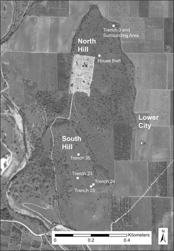
The city of Olynthos is mentioned briefly in ancient historical sources,Footnote 6 but – as is the case for most ancient cities – the texts provide virtually no information about the development and physical characteristics of its urban centre. Archaeological evidence is therefore of crucial importance. Early excavation by David Robinson uncovered a substantial area of housing on the North Hill (Fig. 1) and provided some evidence for the character of the urban centre, identifying an orthogonal street grid, an open area (subsequently understood as an agora), a stoa, a building interpreted as a bouleuterion, and a fountain house. On the South Hill, Robinson located streets, an Archaic ‘Civic Center’ (which seemed to have been destroyed by the start of the Classical period), as well as two further monumental buildings (identified as arsenals) and additional houses.Footnote 7 In the course of further excavation, cleaning, and restoration work by the Greek Archaeological Service (1988–94), the picture provided by Robinson was further nuanced; for example the relatively brief period of occupation on the North Hill was confirmed through the narrow range of material found, even where multiple, superimposed, deposits were identified (e.g. Drougou and Vokotopoulou Reference Drougou and Vokotopoulou1989, 340). Re-analysis of Robinson's data in the 1990s offered some insights into the social lives of Olynthos’ households and aspects of the domestic economy (Nevett Reference Nevett1999, 53–79; Cahill Reference Cahill2002, passim).
Topography of Olynthos showing the locations in which the Olynthos Project has undertaken fieldwork between 2017 and 2019 (David Stone).

While in some ways this earlier work already offered an unusually rich data-set and a correspondingly detailed picture of Olynthos’ urban centre, a range of crucial details were missing: most seriously, the limited range of methods in use when Robinson was working made it difficult for him to understand the nature of the settlement on the South Hill or to estimate the extent and density of habitation, either on the North Hill or on the plain below to the east (referred to by Robinson as the ‘Villa Section’ and by the Olynthos Project more neutrally as the ‘Lower City’). Robinson also hypothesised an extension of the urban grid of the North Hill into the Lower City, although the exterior walls of the houses he excavated there did not always align with his proposed streets (Robinson Reference Robinson1946, pl. 271). In addition, the eastern boundaries of Olynthos were not located with any certainty or precision. At a more fine-grained level, the questions that could be addressed about individual households were limited by the apparent goals of the project, which focused on recording architecture. While some of the finds from individual houses were documented by a team of younger scholars working with Robinson, those recorded were clearly a small proportion of what was originally encountered. The selection criteria were never made explicit, and the stratigraphic contexts of most of the individual pieces were not noted, even if their approximate spatial locations sometimes were (see Nevett Reference Nevett1999, 59–60).
Building on this past research at the site, but keeping in mind the shortcomings of the earlier data, the central goal of the Olynthos Project is to recover a more detailed picture of Olynthos as an example of a Classical city, encompassing its history as well as aspects of its physical, economic and social topographies. The Project's research design adopts a multi-scalar approach to facilitate understanding at the level of the individual household, the neighbourhood, the district and the city as a whole.Footnote 8
The results of geophysical survey within the settlement, as well as surface collection there and in the immediate hinterland, are being used to understand the layout and extent of the built-up area throughout the lifetime of the city. Data from stratigraphic trenches in the oldest district (the South Hill) are revealing details of the long-term occupation history there, while evidence from the upper levels of those and other trenches, as well as from excavation on the North Hill, is providing varying amounts of information about households in the last days of Olynthos’ occupation.
TOWARDS AN URBAN PROFILE OF OLYNTHOS
Data from Olynthos can contribute to wider debates concerning urbanism from a variety of perspectives, through a reconstruction of the process of urbanisation and an evaluation of aspects of its early economic life and cultural links.
Urbanisation: the South Hill
The physical development and organisation of the early community (EBT)
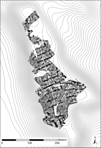
As noted above, Robinson's research on the South Hill brought to light part of the settlement that he referred to as the ‘Civic Center’, together with parts of a few other buildings. However, he did not really understand the sequence and relationship between these buildings, nor the stratigraphy of the area. Furthermore, he suggested that Olynthos was founded by the Bottiaioi (after they had been expelled from their land and moved to the north-western Halkidiki, which was named Bottiki after them) and that the South Hill was the first district to be inhabited, but his excavation did not yield evidence of the earliest settlement (Robinson Reference Robinson1930, x–xi). The Olynthos Project's research on the South Hill concentrated on the history of habitation and the nature of the settlement: these topics were studied through geophysical survey, surface collection and the excavation of six trenches. Work started in 2016 with surface collection, geophysical survey and the excavation of trenches that verified their results (Nevett et al. Reference Nevett, Tsigarida, Archibald, Stone, Horsley, Ault, Panti, Lynch, Pethen, Stallibrass, Salminen, Gaffney, Sparrow, Taylor, Manousakis and Zekkos2017, 187–99). The geophysical survey (electrical resistance and electromagnetic induction) revealed the layout of the settlement on the South Hill: it consisted of two north–south avenues (parts of them had been brought to light by Robinson's research) and at least sixteen east–west streets which intersect with the two avenues at regular intervals without forming an orthogonal grid. The streets located in the northern part of the settlement are straight, but those in the southern part are slightly curved.Footnote 9 Trial trenches confirmed the accuracy of these results. Further electrical resistance (Fig. 2) and magnetometry undertaken in 2017 extended the area covered, while ground-penetrating radar provided information about the stratigraphy in a limited area. We discuss the layout of the district in more detail below in relationship with the other districts of the city. Here we concentrate on the evidence for the history and development of settlement on the South Hill.
Results of the electrical resistance survey on the South Hill following the fieldwork of 2017 (Timothy Horsley).

In the final three years of fieldwork, 2017, 2018 and 2019, we excavated two stratigraphic trenches and extended one of the trenches opened in 2016 to investigate domestic space on the South Hill. All the trenches provided interesting data concerning the history of habitation and the organisation of space.
The development of habitation
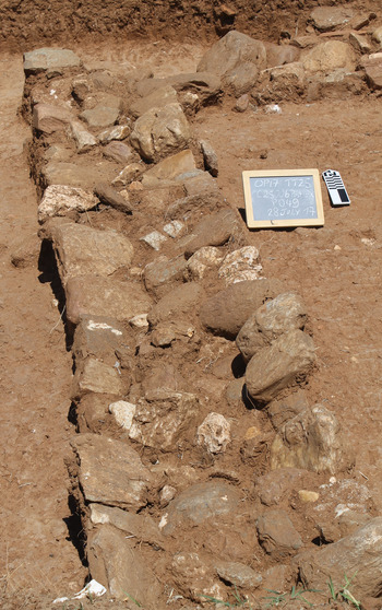
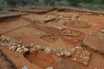
The trial trenches of 2017 revealed that the final occupation of the settlement on the South Hill dates to the same period as that of the North Hill: both were destroyed in the middle of the fourth century bce. Our research on the domestic space was limited (TT24 and TT25: Fig. 1). We investigated part of a street and three rooms of a house that were destroyed in the middle of the fourth century bce. The excavation yielded a large number of ceramic fragments and figurines, along with significant quantities of animal bone. The limited evidence from these trenches shows that domestic space was organised in a significantly different way from contemporary houses on the North Hill. There were also differences in the construction of the walls: mud bricks were occasionally preserved on top of the stone wall socles, and some of the socles consisted of large stones laid to slope inwards towards the centre of the socle (Fig. 3).
Details of Trench 25 viewed from the south, showing large inward-sloping stones in the west wall (Stephen O'Brien).

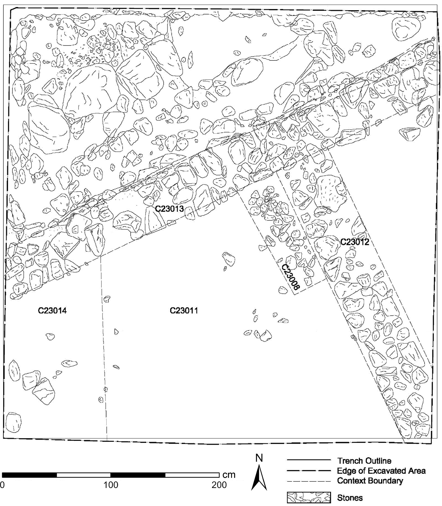
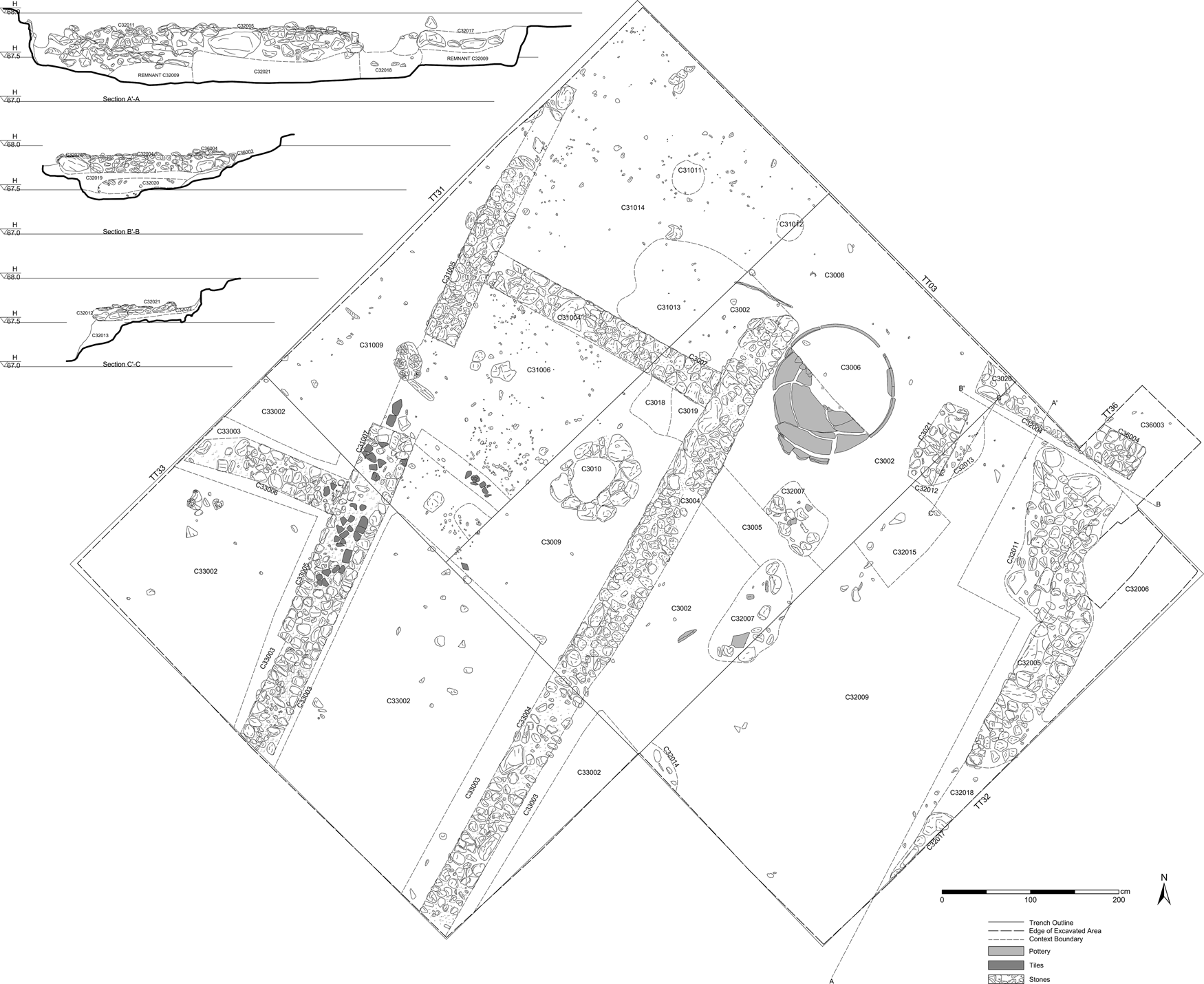
Two stratigraphic trenches were excavated, TT23 and TT35, with the aim of dating the installation of some of the streets making up the grid. TT23 was located in the south-west part of the hill. It measured four by four metres and was laid out on a north–south axis, over one of the slightly curved east–west streets, according to the results of the geophysical survey (Fig. 4). Under the topsoil we located part of a building with the wall of its northern façade and a paved surface to the north, most probably a street. A destruction deposit consisting of tiles, pottery, a few metal objects and animal bones was scattered on the paved street. This material dated the use of the house to the first half of the fourth century bce. The discovery of four post holes in the street, against the façade, implied the existence of a wooden structure there. We did not excavate further inside the house; thus our investigation was restricted to the northern part of the trench, the area of the paved street. Under this street we located a preparation layer and underneath that an earlier paved street consisting of small stones, gravel and pebbles, that also dated to the Classical period. The foundation of the wall of the late Classical house was found in this layer. This earlier street was built on top of a clay-like deposit comprising collapsed architectural material, mud bricks, Archaic pottery, shells and animal bones. This material probably originally belonged to Archaic buildings that were destroyed. Their materials were reused to fill and cover the destroyed buildings, constituting a new level. This clay-like deposit was most probably related to the Persian destruction of 479 bce.
Plan of Trench 23 (Filippos Stefanou).

When this deposit was removed, we came across an ashy deposit with a semi-circular installation of a hearth at the centre and the north wall of a house that extended under the Classical house. This new wall is almost parallel to, and immediately to the north of, the Classical one. Furthermore, we found a series of large stones, almost parallel to and in front of the wall, that probably protected it from erosion by rainwater. A large pit at the centre of the excavated part of the street destroyed part of the wall. It contained imported and local Archaic pottery, Early Iron Age pottery, shells, many fragments of animal bone and a few bones of an infant (or infants). Another large pit related to the Archaic street was seen in the northern and western sections of the trench.
In order to investigate the earliest habitation of the hill and to reach the bedrock, we continued the excavation under the Archaic deposits of TT23. Since we wanted to preserve the features of the Archaic period that had come to light, we investigated a limited area in the western and the eastern parts of the trench. We concentrated on the area between the Archaic wall and the series of stones in the western part of the trench. We located an Early Iron Age deposit and a pit containing Early Iron Age and Prehistoric pottery. Sparse evidence in the eastern part also implies the existence of an Early Iron Age deposit there at a different depth. These scattered data show that the area was probably organised with large terraces extending from the western slope to the centre of the hill. Under the Early Iron Age deposits we located bedrock.
Stratigraphic trench TT35 yielded similar finds. The trench was located north-east of TT23 and measured 3 × 3 m. It was opened over a straight street running east–west, according to the geophysical survey. The excavations located a wall belonging to the south façade of another Classical house and an unpaved open area (the street suggested by the geophysical survey) (Fig. 5). Based on the finds from the fill, the wall and the area in front of it date to the first half of the fourth century bce, the last period of habitation at Olynthos. The interior of the building was not excavated to locate a destruction layer. Instead, investigation concentrated on the open area (street). To the west the foundation of the wall destroyed part of a preexisting pit that accommodated a large pithos, more than 1 m tall, which contained Archaic pottery. Another pit was located along the southern and eastern sections and extended to the centre of the trench. This contained medium-to-large stones and a notable number of ceramics, mainly Archaic pottery, figurines and bones. Under the foundation of the Classical wall, in an Archaic deposit, we came across a second wall, parallel to it and just to its south. This new Archaic wall belonged to a house that extended under the Classical one. Its western end started from the cut of the pit with the pithos. We did not locate the street in front of this Archaic wall, but we located the sub-floor, which was made of small stones, gravel and pebbles. The foundation of the Archaic wall was excavated in this deposit. All the lower deposits of this trench yielded Archaic pottery, bones, shells, a few fragments of Early Iron Age pottery and a few pieces of the bones of infants. The existence of the Early Iron Age pottery implies that the settlement of that period extended to this part of the hill. Since this trench was only opened in 2019, there was no opportunity to continue deeper.
Plan of Trench 35 (Filippos Stefanou).

General characteristics of the settlement on the South Hill
The interim results of this research suggest the following conclusions:
A) The first habitation on the South Hill at Olynthos dates to the Early Iron Age. The sparse evidence implies that the area was organised with terraces extending from the western slope of the hill to the centre.Footnote 10 The pottery of this period is related to the ceramic production of the Thermaic Gulf.Footnote 11 The existence of Prehistoric pottery in a pit of this period has to be further studied and discussed.
B) The Archaic settlement was destroyed. The buildings collapsed and after the destruction a deposit containing, among other things, architectural elements, ceramics, bones and shells covered the ruins. The settlement was rebuilt with the same grid and the buildings on the same orientation. This is seen in the two trial trenches, TT23 and TT35. Thus, we can suggest that the grid was first laid out in the Archaic period and remained the same throughout the history of the settlement.
C) The difference detected in the results of the geophysical survey between the straight and the curved east–west streets is not due to any chronological distinction between them, but is due to the natural landscape. The curved streets, that were also paved, were required in the parts of the hill with inclination, while the straight ones, that did not have to be paved, were used in the flat areas.
D) The district on the South Hill was finally destroyed in the middle of the fourth century bce, like that on the North Hill.
E) The layout of the houses of the South Hill is different from that of the houses of the North Hill, and there are also differences in the construction. The different conception of private and public space in these two contemporary districts (the wooden structure in front of the north wall of the façade of the house on the South Hill in TT23) and different organisation might imply that the inhabitants of the South and the North hills were constructing different identities for themselves, a hypothesis that needs to be investigated further with reference to other strands of evidence.
F) All archaeological deposits on the South Hill yielded animal bones. The quantity of bones from the North Hill is much smaller, and bones are found only in a few deposits.Footnote 12
G) The discovery of the bones of infants in the Archaic deposits of both stratigraphic trenches, TT23 and TT35, suggests specific ideas concerning the social role of infants and has to be studied further.
H) The pottery of the settlement during the Early Iron Age and Archaic periods shows a relationship with the ceramic production of the Thermaic Gulf and presents differences from the pottery discovered in other coastal cities of the Halkidiki (again, see the discussion that follows).
Ceramic evidence for the economic life and cultural links of early Olynthos (AnP)
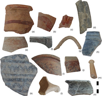
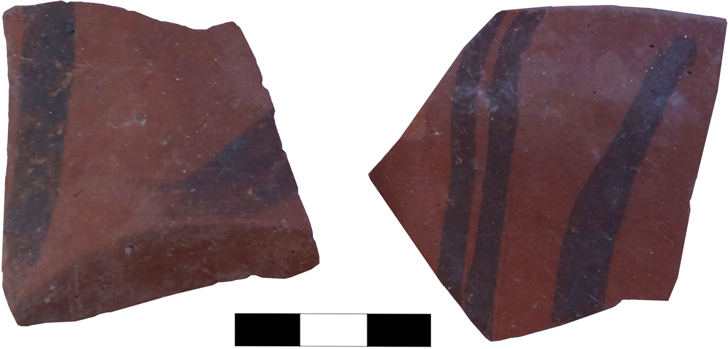
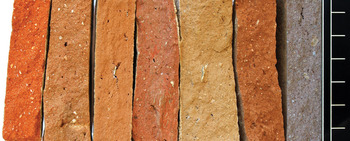
The local and imported wares were similar in both TT23 and TT35. Here we offer an interim summary of the assemblage from TT23, which has so far been studied in the most detail.Footnote 13 The ceramic assemblages of the early habitation phases in TT23 provide some information, not only about the dating of the early settlement, but also about the technologies and economic ties of its inhabitants. The deposits in the lower layers, particularly the fills of the wall foundation trenches and of several pits, differ from the upper levels, dating to an earlier period when hand-made and wheel-made ceramics were manufactured contemporaneously. The wheel-made ceramics can be classified into two broad, distinct types with different origins, based on their fabric, technique and decoration. Local Halkidikian pottery is represented by coarse- and banded-ware (Fig. 6a). A significant number of sherds bear floral or wavy decoration or the common S-motifs (Fig. 6bc). However, the majority of ceramics correspond with the local production tradition of the settlements that developed along the coastal zone of the Thermaic Gulf as well as in its hinterland during the Iron Age, in particular from the eighth century to the end of the sixth century bce (Panti Reference Panti2008, 151–220). Pottery with banded decoration on a dark brown or orange outer surface is predominant in this group. The most common shape seems to be the jug with a cut-away neck and a double handle (Fig. 6d). A significant quantity of monochrome ware, with both thick and thin walls (or ‘egg-shell’) also appears. Cups with a hemispherical body, a flat base and either a plain rim or a rim that is triangular in section with a flat upper surface dominate (Fig. 6e–g). Grey ware with or without burnished, striped decoration (Fig. 6h) and ‘silvery’ ware are also common. Both were produced without typological differentiation from the eighth century until the end of the sixth century bce. ‘Silvery’ ware is decorated with horizontal zones bearing concentric circles, wavy lines etc. (Fig. 6ij). The same decorative motifs also appear on a body fragment, probably from a small pithos with close parallels from Vergina and Karabournaki (Fig. 6k). A few fragments may be associated with the famous Sub-Geometric-type trade-amphora decorated with concentric circles, produced in the region of Sindos (Tiverios Reference Tiverios, Tiverios, Nigdelis and Adam-Veleni2012, 179). Hand-made ware, referred to as Iron Age pottery (Tiverios Reference Tiverios, Tiverios, Nigdelis and Adam-Veleni2012, 181–3), coexists with these wheel-made types, as mentioned above. The principal shape is the jug with a cut-away neck and a twisted or a double handle (Fig. 6l). Phialai with plain rim and a wish-bone or everted handle with ‘mushroom’ type finial are also common (Fig. 6m). Relief ‘rope’ decoration with a row of fingernail impressions appears on cooking ware (Fig. 6n). Τhe lowest layers yielded Late Bronze Age to Iron Age hand-made ceramics with black-on-red or finger-impressed decoration (Fig. 7).
Local early pottery from Trench 23 (Anna Panti).

Iron Age hand-made ceramics from Trench 23 (Anna Panti).

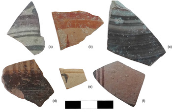
Imported ware, although infrequent among the finds of these lower layers of TT23, suggests commercial relations with several Mediterranean centres. The limited numbers of black-gloss pieces are all from Attic workshops. There are only a few Corinthian imports, but they are distinctive (Fig. 8ab). The limited presence of Late Geometric Euboean imports, for example sherds of an oinochoe with linear decoration (Fig. 8c), is evidence of the dynamic Euboean colonising activity on the coastal zone of the Halkidiki peninsula at that time. A unique fragment of a Subgeometric skyphos from Thasos reveals contacts with that neighbouring island (Fig. 8d) (compare Blondé, Perreault and Péristéri Reference Blondé, Perreault and Péristéri1992, 11–40). Trading relations with East Greek centres during the sixth century bce are indicated by several Ionian type B cups and contemporary kotyle fragments with birds on the handle-zone (Fig. 8e). These are difficult to identify either as East Greek products or as local imitations of the well-known type, since such vessels were both imported and produced in the region of Central Macedonia (Georgiadis Reference Georgiadis, Kefalidou and Tsiafaki2012). However, the earliest import of East Greek origin seems to be a body fragment with vertical lines (Fig. 8f) recalling cups with a bird at the centre and a rhombus on each side of a metope, dating to the seventh century bce (Tsiafakis Reference Tsiafakis, van Der Wielen-van Ommere and De Lachenal2008, 10). It is worth noting that the South Hill at Olynthos is the first site in the Halkidiki where a large quantity of ceramics in the tradition of the local pottery production of the Thermaic Gulf region has been unearthed. ‘Egg-shell’ pottery is found only in a few places in the peninsula (for instance at Sane and Nea Kallikrateia). ‘Silvery’ ware is also only sporadically mentioned among the finds of Halkidikian assemblages. There is undoubtedly a significant difference between the Iron Age finds of Olynthos and those of the coastal colonies like Mende, Torone and Akanthos.
Imported ceramics from the lower levels of Trench 23 (Anna Panti).

The classical cityscape
Having explored aspects of the early settlement on the South Hill together with its economic functioning, we turn now to the city of Olynthos during its final phase of occupation between the later-fifth and mid-fourth centuries bce – the period for which we have the most extensive evidence and when the settlement extended over both the South and North hills and onto the eastern plain below.
Estimating the extent of the city (DLS)
The surface collection, geophysical survey and excavation, together with Robinson's legacy data, provide a basis for evaluating the extent of the ancient city, and the degree to which the excavated area may be representative of the city as a whole. Nicholas Cahill estimated the size of Olynthos at 51 ha and the extent of previous excavation at 4.5 ha (Cahill Reference Cahill2002, 30–2). The first estimate appears to be reasonably accurate, but the second is manifestly too low on the basis of trenches shown in Robinson's fold-out map (Robinson Reference Robinson1946, pl. 272). The work of the Olynthos Project suggests that the city extended over about 54 ha, although given some uncertainty about the precise boundaries on the eastern side, it would be better to suggest a range of 50–60 ha. The digitised outlines of Robinson's trenches suggest that his excavations within the city encompassed a minimum of 7.5 ha – not including areas where he dug outside the city proper, such as the four Classical cemeteries and the Church of Aghios Nikolaos. This figure is certainly a minimum estimate because the Olynthos Project has discovered a number of locations where trenches appear to have been excavated, perhaps by Robinson, although they are not included on any published map. For example, it appears that Robinson searched for a theatre on the south slope of the South Hill, and we did find a trench there, but it is not marked on any of Robinson's plans. Still, a figure of c. 7.5 ha for the excavated area indicates that we know about a much larger percentage of the city than was previously recognised, which should increase confidence in our ability to draw conclusions about it.
Robinson's excavations took place in several areas of the North Hill, South Hill and Lower City. The extent of his work on each one might suggest that all three of these major districts are now well documented, but that is not the case. One should consider the regular plan of streets and house blocks on the North Hill, where Robinson excavated 5.28 ha, to be the only element clearly understood. As noted above, on the South Hill, the street layout, organisation of civic and domestic structures, multiple phases and date of initial occupation eluded Robinson, despite his excavation of approximately 1.49 ha (or 26 per cent) of the total of the 5.73-ha hilltop. In the Lower City, where Robinson excavated 0.73 ha, the density of occupation is poorly known, and both the eastern boundary of the city and the possible construction of a fortification wall protecting the houses located here are uncertain. The city's western boundary is much better-defined, being marked by cemeteries investigated by Robinson and by the Olynthos Project's geophysical work and field survey (see below).
Characterising the districts and immediate hinterland of the late Classical city
Urban layout (DLS; AS, NP and JD; LCN)
By integrating the legacy data with our newer geophysical results, surface survey data and excavated evidence, we are able to compare and contrast aspects of the different residential districts, namely the South and North hills and, to a lesser extent, the Lower City. (This last area lies beyond the boundaries of the modern archaeological site, and the Olynthos Project has therefore investigated it only through surface collection and geophysics. The survey permit did not extend far into the area west of the two hills, but this seems to have lain outside the city, given the presence of the cemeteries noted above, and also the seasonal river that flows through here as well.) On the South and North hills, an arbitrary grid of squares measuring 30 × 30 m created within the fence of the modern archaeological site served as the basic unit for collection of both surface artefacts and geophysical data. Several key areas were chosen to determine the extent, depth and layout of settlement through geophysics. A total of 0.38 km2 (38 ha) was explored with geophysical techniques from 2014 to 2017,Footnote 14 with the majority (0.28 km2) examined in 2017. Some of the coverage was overlapping – as good outcomes can often be achieved when different techniques are employed over the same area so that results can be compared. The total area newly explored with geophysics was thus 0.24 km2 (23.5 ha). In the field survey, the Project covered 234 grid squares (0.21 km2) in total, with 166 of these surveyed between 2017 and 2019. Despite the presence of considerable vegetation across the archaeological site today, all artefacts on the surface of approximately five per cent of each grid square were collected, and a grab sample of diagnostic artefacts was collected in the remainder of the square. The methodology for each survey has been summarised elsewhere (Nevett et al. Reference Nevett, Tsigarida, Archibald, Stone, Horsley, Ault, Panti, Lynch, Pethen, Stallibrass, Salminen, Gaffney, Sparrow, Taylor, Manousakis and Zekkos2017, 161–3), and will be presented in depth in our final report.
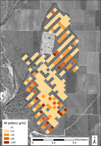
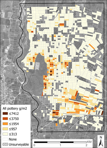
The surface survey of Olynthos highlights differences between the city's housing districts (Fig. 9). The South Hill contains some of the densest concentrations of tile and pottery. These concentrations are highest towards the south end where Neolithic and Byzantine occupation are known in addition to that of the Classical period, but significant quantities of material are also evident across the top of the hill. On the western slope of the South Hill there are additional dense concentrations, although these appear to be a result of material eroding off the edge of the hill or dumped over the side of the hill at the time of Robinson's excavations. Widespread distribution of artefacts on the North Hill indicates that there is likely to have been continuous settlement even in areas where Robinson's excavations did not sample extensively. Between the two hills, where there is a gentle slope down towards the Lower City, the density of material declines. Here, as elsewhere in the lower elevations within the fenced area of the archaeological site, the concentration of material is much diminished, probably because there was little settlement of the lower areas in antiquity, but possibly also because of alluvial and colluvial deposition.
Density of all pottery collected during surface collection within the fenced area of the archaeological site (David Stone).

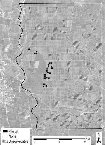
The city extended beyond the fence of the site, where our analysis considers material from the field walking in addition to the grid collection (Fig. 10). The field walking data show concentrations of material on the slopes of the North and South hills. This material is found particularly at the higher elevations on the slopes, but the intensity of the concentrations is diminished as one descends the slope towards the east. The intensity is lower towards the northern end of the North Hill as well. Preliminary distribution maps suggest some broad patterns that will be tested and refined through further artefact study. Plaster – at this point encompassing both painted wall plaster and floor mortar – is a specific category of evidence that is useful for thinking about the location of the inhabited area of the fifth and fourth centuries bce. Outside the fenced area of the site it is found in several of the fields with high densities of material where we have been suggesting the city extended to the east of the modern site boundary (Fig. 11). To the west of the North Hill, archaeological materials may also be found on the ground surface. Very little material – and in some fields none at all – was discovered on the level ground to the south and west of the South Hill, where alluvial deposits extend from the river.
Density of all pottery collected during field walking beyond the fenced area of the archaeological site (David Stone).

Distribution of plaster collected during field walking beyond the fenced area of the archaeological site (David Stone).

Geophysical survey has much to add to this picture of the city's topography. We have already noted that on the North Hill orthogonal housing blocks resembling those excavated by Robinson (consisting of two rows of five houses separated by a narrow drainage alley or stenopos) extended to the north-eastern part of the North Hill as they did in the north-western area where he excavated, and that at the north end of the North Hill there was a less dense and somewhat open area without buildings on the main grid plan (Nevett et al. Reference Nevett, Tsigarida, Archibald, Stone, Horsley, Ault, Panti, Lynch, Pethen, Stallibrass, Salminen, Gaffney, Sparrow, Taylor, Manousakis and Zekkos2017, 166). On the South Hill, as outlined above, further work carried out between 2017 and 2019 supports the reinterpretation of the character and layout of the entire district, suggested in Nevett et al. Reference Nevett, Tsigarida, Archibald, Stone, Horsley, Ault, Panti, Lynch, Pethen, Stallibrass, Salminen, Gaffney, Sparrow, Taylor, Manousakis and Zekkos2017, 188. The layout of the South Hill was originally identified as ‘chaotic’ by Robinson (Reference Robinson1946, 279), or as ‘less regular’ by Wycherley (Reference Wycherley1962, 21–3), interpretations echoed by Hoepfner and Schwandner (Reference Hoepfner and Schwandner1994, 74–6 with fig. 56) and Cahill (Reference Cahill2002, 27). We argue that, to the contrary, the South Hill had an organised plan, albeit the orientation of the streets is different from those of the North Hill (running north-west to south-east, rather than a little east of due north–south), and the layout is not orthogonal (Fig. 2). Two main avenues appear to have run along the east and west sides of the hill. In the wider southern part of the hill, there was a third avenue that split from the East Avenue and ran down the centre. Perpendicular to the avenues we have now detected a minimum of 16 streets. In the north they ran straight across the avenues, but in the wider south, where there were three avenues, the streets did not cross the central avenue in orthogonal fashion. Instead, they were staggered, with the result that it was not possible to take a straight path across the hill.
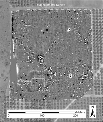
Many houses and buildings appear to be visible in the geophysical results from the South Hill, although, unlike on the North Hill, it is difficult to assess their number or to determine their plans because they do not appear to have had standard shapes, sizes or features. No cobbled courtyards, open pastades or paved andrones are immediately recognisable. The three-room ‘oecus unit’, so characteristic of the houses excavated by Robinson on the North Hill and also present in house B ix 6, excavated by the Olynthos Project (see below), is also impossible to see. Instead, the irregular placement of the walls is (unsurprisingly) closer to the arrangements in the structures Robinson excavated on the South Hill, whose plans were difficult to make sense of as self-contained buildings, partly because of their lack of regularity and partly because he was frequently unable to find evidence for the doorways connecting the spaces (Robinson Reference Robinson1946, 272). Nevertheless, the very different proportions of the blocks themselves are striking: on the North Hill they each measure approximately 36 × 84 m (counting both rows of houses and the stenopos in between). On the South Hill fewer complete blocks can be observed, and the dimensions are more variable due to the irregular shape of the hill, but the central blocks are much narrower, measuring approximately 20 × 80 m. This must have meant either that the individual houses were far shallower front to back, or that streets ran both at the front and the back of each one.Footnote 15 Either way, the experience of occupying the houses on each hill must have been very different in terms of the arrangement of space, the penetration of noise and the range of possible ventilation or light sources. In the Lower City, the size of some of the houses excavated by Robinson is also somewhat less standardised than on the North Hill (see Robinson Reference Robinson1946, pl. 272). To enhance the information from his excavations, we investigated all of this district with surface survey, and five locations with geophysical techniques. A less dense distribution of buildings is suggested by the sparser scatter of archaeological materials in some areas, but the key element is the changing density of settlement in the excavation and geophysical results. These results indicate that parts of the district had closely grouped houses, but elsewhere there were single houses and open spaces (Fig. 12). As for road alignments, we note that these exist along the boundaries of the excavated houses and buildings visible in geophysical results. They do not always appear to follow the lines that Robinson extrapolated from the North Hill grid (East Spur Hill 4 and ‘Villa of the Bronzes’).
Results of the magnetic survey on the east side of the South Hill (Apostolos Sarris).

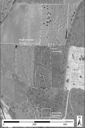
Moving outwards from the core of the city, an important revelation about its layout is the extent of the cemetery on the western side. Robinson excavated two cemeteries here, which he called the ‘Riverside’ and the ‘North’ cemeteries. The Olynthos Project's new results demonstrate that both are part of a single, much larger cemetery that stretches from the Riverside cemetery in the south along the city wall for at least 450 m to the north, beyond Robinson's North Cemetery (Fig. 13). This cemetery extends in places at least 160 m to the west of the city wall. At minimum, it is five to six ha in size. Its signature in the results of the magnetic survey is comprised of many, small, irregularly spaced but densely clustered strong positive–negative anomalies. The disordered arrangement is consistent with the pattern of burials identified in earlier excavations (Robinson Reference Robinson1942, 138). The field survey identified tile tombs in three places along the western slope of the North Hill as well as, in one instance, a human tooth. These locations fall within the broader area in which geophysical techniques succeeded in detecting the western cemetery area of Olynthos.
Results of the magnetic survey on the north-west side of the North Hill (Apostolos Sarris).

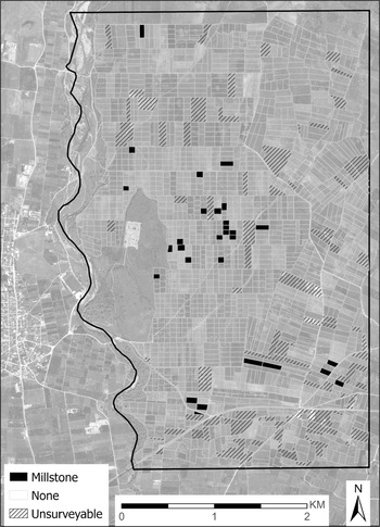
At a greater distance from the urban centre, the Olynthos Project study area contains widespread material of Classical date. Although few Classical rural sites are easily identified, the presence of cut stone blocks, loom weights and mill stones is suggestive of occupation of the countryside during the city's heyday – the fifth and fourth centuries bce – in specific places (Fig. 14). The course of the city's aqueduct is detectable from the city centre all the way to the north-eastern corner of the study area. Additional effort is needed to analyse the ceramic finds from the survey, not only to date materials, but also to understand the composition of surface assemblages, and to examine these assemblages for suggestions of functional variation throughout the survey area.
Distribution of mill stones collected during field walking beyond the fenced area of the archaeological site (David Stone).

In summary, although our different sources of evidence are variable in kind and in the level of detail they provide, comparisons between the different districts of the city suggest that they contrast with each other quite markedly. Whereas the South Hill retains the pattern of narrow streets and building blocks first established during the Archaic period, the North Hill was laid out on a regular, orthogonal grid plan. Here the broad streets and avenues cross each other, intersecting at right angles and continuing the same line. Between them the regular, rectangular housing blocks are almost twice the depth of those on the South Hill, each one providing space for a double row of five houses placed back-to-back. While the Lower City has been investigated less intensively, the density of buildings here seems to be lower (see below).
There are still unavoidable gaps in our knowledge of some parts of the site due to modern patterns of vegetation and land-use.Footnote 16 Nevertheless, our new understanding of the organisation of the South Hill based on the geophysical coverage suggests that the majority of the city's civic spaces were clustered together at its centre, in an area that spans the northern end of the South Hill (Robinson's ‘Civic Centre’ and ‘Arsenals’) and the southern part of the North Hill (the Agora and adjacent stoa, fountain house and ‘Assembly Hall’).Footnote 17
Settlement density of the districts and population size (DLS)
Based on our new, more detailed picture of the extent of settlement in the different districts of Olynthos, it is possible to offer a firmer estimate of the density of settlement, and hence to estimate the city's population size. The latter is a subject treated in some depth by previous scholars who have carefully evaluated the site and composed estimates for the population of Olynthos ranging from 3000 (Cahill Reference Cahill2002, 37–41; Price Reference Price, Bowman and Wilson2011, 22–3) to 5000 (Hansen Reference Hansen and Hansen1997, 30), 10,000 (Hoepfner and Schwandner Reference Hoepfner and Schwandner1994, 72), and 12,000–15,000 (Robinson and Graham Reference Robinson and Graham1938, 44, superseding an earlier estimate of 20,000–30,000: Robinson Reference Robinson1930, xi).Footnote 18 These previous scholars all base their estimates on the evidence from Robinson's excavations rather than on the testimony of ancient literary sources. While there are three literary sources for the population of Olynthos, none of them clearly states the population of the city at any date (Demosthenes 19.263–6; Xenophon 5.2.14; Diodorus Siculus 16.8.4; 32.4.2.). At the same time, modern scholars do not all base their information on the same archaeological evidence, nor do they offer an estimate of the population at the same date.
The data from the Olynthos Project provide a new means of calculating population size. We propose estimates for the South Hill, North Hill and Lower City districts in the middle of the fourth century bce, based on our geophysical and field survey results, as our evidence suggests different occupation densities in each area. The top of the South Hill measures 5.73 ha. The ‘Civic Center’, ‘Arsenals’ and other uninhabited space account for about 0.4 ha, leaving 5.3 ha covered by residential buildings and roads. The highest-density area of housing on the North Hill runs from south of the Agora to the fortification wall at the north end of the hill, and from the east to the west side of the hill. We calculate that this space includes about 19 ha, but if we exclude open spaces, such as the Agora (1.2 ha) and the north-eastern corner of the North Hill (perhaps 0.5 ha), we reach about 17 ha of dense settlement on the North Hill. We calculate about 440 houses in this thickly settled area. Settlement in the Lower City on the eastern slope of the North and South hills was far less dense, as both our geophysical and field surveys reveal. In this area of about 25 ha, there were perhaps 90 houses. We reached this estimate by counting individual houses visible in our geophysical survey (about 22 houses over 6.16 ha) and extrapolating (cf. Figs 11 and 12). Our evidence for this part of the city is not extensive, and our sample may not be representative of the full 25 ha, so we acknowledge some uncertainty here. Still, we think that our evidence for the Lower City is clearer than that available to previous scholars. Hansen (Reference Hansen2006, 43), for example, discounts this area entirely as a proasteion and not part of Olynthos, although it seems more probable that it was a part of settlement that was never completely built up at the time of the city's destruction. In total, therefore, about 29 of the 50–60 ha built-up area of Olynthos has been examined either through excavation or geophysical survey. Field walking has sampled the remainder. We therefore possess information about a relatively high percentage of the city – perhaps as much as any ancient Greek city – to gauge the population size.
Estimates of the populations of ancient cities are often based on the size of the roofed area of individual dwellings, the number of people per house or the number of people per hectare.Footnote 19 At Olynthos, our evidence incorporates all of this information, but we draw most specifically on figures for the number of people per house and the number of people per hectare in creating the following estimates. Olynthian houses on the North Hill were approximately 290 m2 in size, grouped in 10 houses per block, and there were approximately 26 houses per ha in the residential districts.Footnote 20 Since Olynthian houses normally contained both a courtyard and a pastas, neither of which was enclosed, the total walled and roofed living space in the average Olynthian house was approximately 290 minus 37Footnote 21 minus 33Footnote 22 = 220 m2. The figure of 220 m2 includes only the area of the ground floor, not the upper storey, whose presence and size cannot be ascertained without careful excavation. Therefore, we use this figure as a basis for assessing the average number of people per house, although it certainly understates the size of some Olynthian houses.
-
4 people per house, at 220 m2 per house = 1 person per 55.0 m2.
-
6 people per house, at 220 m2 per house = 1 person per 36.7 m2.
-
8 people per house, at 220 m2 per house = 1 person per 27.5 m2.
-
10 people per house, at 220 m2 per house = 1 person per 22.0 m2.
Next, we use the figure of 26 houses per ha on the North Hill to suggest the implications of the choice of the number of individuals living in a house.
-
4 people per house, if 26 houses per ha = 104 people per ha.
-
6 people per house, if 26 houses per ha = 156 people per ha.
-
8 people per house, if 26 houses per ha = 208 people per ha.
-
10 people per house, if 26 houses per ha = 260 people per ha.
For the moment let us pursue the implications of one of these estimates: 6 people per house, or 1 person per 36 m2 and 156 people per ha. Using this figure, we calculate that the North Hill had a population of 2652 people (17 × 156) and the South Hill had a population of 827 people (5.3 × 156). While this figure suggests a high density of population on the North and South hills, where we know there was little open space, it implies a much lower density in the Lower City. Here it yields a population of 525 people (6 people per house with 3.5 houses per ha, or 21 people per ha x 25 ha). Adding the estimated population in the three districts together generates a total population at Olynthos of 4004 people (2652 + 827 + 525).
A word of caution should be expressed before we take the discussion further. We do not have information about family structures or the extent of slaveholding, which would be helpful in determining whether an estimate such as 4, 6, 8 or 10 people per house is more reasonable. Likewise, we cannot say that all of the houses we can identify in the geophysical and excavation data were occupied contemporaneously, which means that our suggestion of 26 houses per ha may be too high. At the same time, estimates of 6 people per house and 26 houses per ha allow us to occupy a sort of middle ground between the possibility of relatively large families and more limited contemporaneous habitation. We therefore offer an estimate of approximately 4000 people as the population size at Olynthos in the mid-fourth century bce, in the years just before the sack by Phillip II. The population of the city might have been at its highest at this time as this probably corresponds to the period in which the greatest number of houses had been constructed in the three districts.
This discussion of various physical characteristics of the districts can be supplemented by considering other dimensions of the Olynthos Project evidence, which speak to aspects of the social and symbolic spheres, including the cultural preferences of their inhabitants.
Consumption practices in the different urban districts (LCN)
Examination of consumption preferences of the inhabitants of the different districts of the city will eventually provide an insight into how they constructed their identities through their individual and shared cultural practices. This issue can be addressed using a range of different data-sets. Here we highlight the potential of faunal, microdebris and ceramic evidence to characterise some of the activities involved in the storage, preparation and consumption of foods. Dimensions for study include the range of meats selected, the methods used to process and store foodstuffs, the styles of cooking adopted and the modes of serving used. In addition, these sources can also be used to reconstruct the spatial organisation of domestic activities as well as to look at some of the choices made about what kinds of goods to procure. Analysis is presently ongoing, but first indications from the faunal and microdebris analyses are that there were significant contrasts in some of these practices between the inhabitants of the North and South hills. The material from the South Hill also offers an opportunity to trace how such practices may have changed through time in a single district. Although the findings are very preliminary, they offer an indication of the kinds of approaches that can be adopted. Our ceramic studies are at a similarly early stage because of the sheer quantity of material involved, but the volume and richness of that assemblage also offers the potential to explore variation across the site statistically, based on a range of different dimensions that we signal below.
Faunal evidence (SMS)
The faunal material from the South Hill represents a stark contrast to the North Hill, where only a small number of bones were present, occurring in only a few deposits (see Stallibrass in Nevett et al. Reference Nevett, Tsigarida, Archibald, Stone, Horsley, Ault, Panti, Lynch, Pethen, Stallibrass, Salminen, Gaffney, Sparrow, Taylor, Manousakis and Zekkos2017, 197–9). On the South Hill the remains are relatively plentiful and are quite well preserved. They appear to be standard occupation refuse discarded by the people inhabiting the area. The upper levels contain material with different states of preservation: some fragments are well preserved but others have edge- and surface-damage that suggests re-deposition and is in keeping with the mixed ceramic assemblage in the area. The nature of the animal bone material appears similar throughout the stratigraphy: various parts of the body are represented, breakage and butchery are common, some fragments have been chewed by dog-sized carnivores and a few have been burnt. These characteristics are all typical of domestic food waste.
Trench TT23 (investigated from 2017 to 2019) produced 1001 fragments of hand-recovered animal bone. These derive predominantly from the standard major domestic livestock species of sheep, goats, cattle and pigs. Of the 378 fragments that could be identified to these taxa, sheep/goat account for 248 (66 per cent), followed by cattle (74, i.e. 20 per cent) and then pig (56, i.e. 15 per cent).
The other trenches on the South Hill produced smaller quantities of very similar materials and species proportions. One bird tibiotarsus fragment is almost certainly from domestic fowl (chicken, Gallus domesticus). A few bones of equids (small horse or mule rather than donkey) and dog have also been found. Some of the horse/mule bones have cut marks on them. A few small bones or bone fragments are acid etched and have almost certainly passed through the guts of animals – probably dogs. Bones of wild species are rare, but apart from occasional hare bones (Lepus sp.) there is also one incomplete bone of a canid that is much smaller than the definite dog bones and is fox-sized (possibly fox, Vulpes vulpes), as well as the antler of a deer.
The residues from bulk sediment samples include plenty of small fragments of unburnt, burnt and calcined bone, emphasising the ubiquity of animal remains in the South Hill trenches. Most of these finds are either small items (such as loose teeth and toe bones) or small fragments of larger bones from livestock-sized animals, but there are also a few from small mouse-sized mammals and occasional bones from fish. At least one of the fish species is freshwater (carp family). Coastal or marine resources are represented by a variety of marine molluscs including bivalves and gastropods. These occur in very small numbers but are widely distributed.
Microdebris (BH, ES)
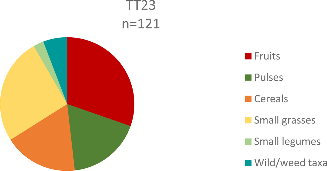
Between 2017 and 2019, 3,187 litres of soil were floated to retrieve paleobotanical remains as well as small artefacts and ecofacts caught in the heavy fraction by the flotation process. The samples were taken from house B ix 6 on the North Hill and from the South Hill trenches. Processing of the heavy fractions is as yet incomplete, but 259 samples were sorted over the three years.Footnote 23 Sampling focused on gathering soil from a variety of contexts, with the aim of recovering plant remains wherever possible and also gathering microdebris from a variety of contexts and features. This established a ‘baseline’ of inclusions and a consistent sampling routine to help teams remember to take samples regularly. Almost all excavation contexts, with the exception of some topsoils and fills already encountered in other trenches, were sampled. Features such as flues, pits and mudbrick walls were similarly sampled, both to recover botanical materials and to gain a better understanding of the composition of a range of contexts. Road and floor surfaces received special attention for reasons discussed below. Spatially, the main focus was on house B ix 6, where each room was sampled and floors were sampled on a grid to allow for spatial patterning analysis.
Precise quantification of artefact densities and variability need to await final study, but some further patterns in the distribution of particular artefact- and material-types were noted that relate to differences in the spatial origins of the samples. In common with the distribution of larger bone fragments (noted above), charcoal and bone in microdebris have been found predominantly on the South Hill: 88 per cent of South Hill but only 28 per cent of North Hill samples include bone. Furthermore, on the North Hill organic material is found mostly concentrated in ashy deposits, and the quantities are smaller. This was not the result of taphonomic processes caused by acidic soil, because pH testing showed that the soil is close to neutral. Further analysis is needed to determine what explains the striking scarcity of bone in most parts of house B ix 6. The South Hill deposits also yielded more ceramics than those from house B ix 6, in line with the broad range of finds recovered by the excavators on South Hill.
Some preliminary observations can also be made regarding roads and interior floors, since both types of contexts were excavated and sampled on the North and South hills. It might be expected that the roads would yield a greater variety and quantity of debris than floors if they were used for disposal of refuse. Our analysis found little difference in density of pottery by weight between the two types of surface, but a significantly greater density of bone by weight in the road contexts. We tested diversity of material from the two types of context and found that diversity was slightly higher in the case of floors. Given that more of the samples sorted came from floors (75) than roads (13), it will be interesting to see if this pattern holds true after more samples from road contexts have been sorted.
Ceramics (NA; BAA)
A variety of red-figure, black-gloss, plain- and coarse-wares of Classical date, from both the North and South hills, have the potential to provide insights into some of the cultural preferences of the inhabitants of the two districts. At present it is too soon to say whether there are significant differences in the shapes, sizes, fabrics, decoration and iconography, or even workshops, favoured in the different districts. However, the large amount and wide variety of the ceramic material offers significant scope for this kind of analysis once excavation and survey pottery have been studied in full and quantified, and the figures considered alongside the material from the surface collection.Footnote 24 Here, we demonstrate the potential of this material to address cultural preferences (among other questions) by discussing selected examples of vessels of various types from the excavation assemblages that show the range and variety of evidence present.
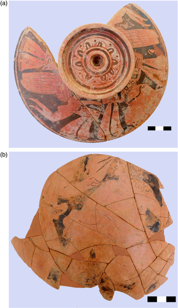
The red-figure pottery from the excavations includes both Attic and local wares, although the former are generally more numerous. Amongst the notable Attic examples is a well-preserved, though fragmentary, lekanis lid from the northern part of house B ix 6, which is decorated with two female figures and two Erotes (Fig. 15a). This can probably be associated with the Group of the Nuptial Lekanides, and it also shows some resemblance to the Painter of Salonica 34.1 or his workshop.Footnote 25 The lekanis should probably be dated around 360–350 bce. Another red-figure lekanis with a Dionysiac scene found by the Olynthos Project in 2015, also in the northern part of B ix 6, should be attributed to the same workshop.Footnote 26
Examples of Attic red-figure vessels (Nikos Akamatis; scale in cm).

A red-figure pelike (C30008PT07) from close to the western boundary of B ix 6 is similarly relatively well preserved (Fig. 15b). The vase shows Dionysos and a standing female figure, probably a Maenad. Dionysos’ posture, as well as the rendering of the details of his head and torso, can be compared with those of Dionysos on pelike B2232 from the Hermitage. This vase was dated to 360–350 bce by K. Schefold (Reference Schefold1934, 51, 141, pl. 8, fig. 2), a dating which is also quite possible for the pelike from Olynthos. Other Attic red-figure vessels include a further pelike and a range of smaller vessels such as a squat lekythos with palmette decoration which has parallels from the second quarter of the fourth century bce (Robinson Reference Robinson1950, 153, pl. 105, nos 113, 115; pl. 106, no. 119; Lilibaki-Akamati and Akamatis Reference Lilibaki-Akamati and Akamatis2014, 192, fig. 86 [second quarter of the fourth century bce]; Akamatis Reference Akamatis2018, 212, no. 21, pl. 111 [370–350 bce]).
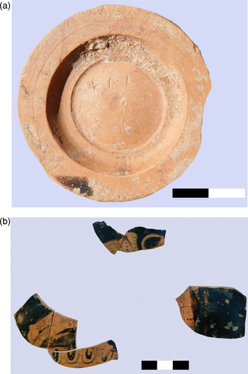
Fewer examples of locally produced red-figure vessels have been identified. The better-preserved examples include part of a small hydria, found in the north-west corner of B ix 6 (Fig. 16). It is decorated with a partially preserved, flying Eros.Footnote 27 The pale brown colour of the clay and the dull glaze allow it to be attributed to the workshop of Halkidiki.Footnote 28 It can possibly be dated around 370–350 bce.Footnote 29 On the underside of the base a graffito with the letters KΛΕ could mark the initials of its owner. Other vessels attributable to the workshop of Halkidiki are more fragmentary.
Red-figure hydria with graffito (Nikos Akamatis; scale in cm).

Black-gloss pottery is much more numerous than red-figure. Various shapes have been identified, mostly preserved in a fragmentary state. These are mainly bowls, one-handlers, bolsals, Attic-type skyphoi and oinochoai. Furthermore, a few fragments of lamps, lekanides, askoi, lekythoi and other shapes have been identified. The vessels are a mix of local and Attic products. Characteristics of local production include the colour of clay, which is usually light brown or pink. The slip is often dull and easily flaked, although in some cases there are vases with a shinier slip on part of, or even the whole, surface. On most vases there is a significant amount of mica, not only on the reserved surfaces, but also in the slip, in contrast with the Attic examples. Moreover, some vases are only partly slipped, normally on the upper part of the body, rim and handle, a decoration technique that is especially common in northern Greece. Local vases are usually small in size and imitate Attic models. Thus, in some cases it is difficult to distinguish between fine quality local vases and Attic variants of a lower quality.
Most of the well-preserved, black-gloss vessels are from the collapse debris of house B ix 6. Among the Attic material, part of the neck of a pelike (from the centre of the pastas in B ix 6) is decorated with an olive branch formed with applied clay. Traces of gilding are evident. The vase could have been red-figure, black-gloss or ribbed. This type of decoration is quite common by the end of the second quarter of the fourth century bce, and throughout the second half of the fourth century bce.Footnote 30 Part of an Attic squat lekythos decorated with a net pattern was found in TT 23 on the South Hill. These lekythoi, related to the Bulas Group,Footnote 31 are quite common at Olynthos, and in northern Greece in general, and are dated to the second and third quarters of the fourth century bce.Footnote 32 In the central pastas/courtyard area of B ix 6, parts of at least two Attic bowls or one-handlers with stamped decoration have come to light. In contrast with the bulk of the pottery from this area, which can be dated to the fourth century bce, these can be dated to the last quarter of the fifth century bce.Footnote 33
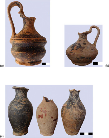
Especially interesting among the finds from 2017 to 2019 are numerous small liquid containers. Examples from the north-west corner of house B ix 6 include an epichysis, three olpai and an oinochoe, all of which are of local manufacture. The epichysis (Fig. 17a) has a ring base, a curvilinear body, a conical neck and a handle that rises above the vase and joins the neck. This is a rather common shape in fourth-century bce South Italian workshops but rarely appears in mainland Greece. At Olynthos, several variations of the shape appear, including black-gloss, red-figure and at least one example decorated with silhouette motifs.Footnote 34 The oinochoe has a disc base, biconical body profile and rising handle (Fig. 17b). Several similar examples were also found in Olynthos during Robinson's excavations (Robinson Reference Robinson1933, 223–4, nos 805, 807, 809, 815, pls 171–2; Reference Robinson1950, 250–1, nos 432, 437, pl. 169). Finally, the olpai (Fig. 17c) belong to different variations of a shape that is extremely popular not only at Olynthos but also in northern Greece more generally.Footnote 35
Examples of small black-gloss containers of local manufacture from house B ix 6 (Nikos Akamatis; scale in cm).

Alongside Attic and local fine-wares such as these, the Project has also documented all vessels of medium household-ware (‘medium-ware’) and coarse-ware encountered. The medium-ware vessels make up the largest class, accounting for very approximately half of the total, by weight. They represent a broad array of shapes: basins, bowls, jars, jugs and lids (with identifications based on fragmentary anatomical features: rims, handles, bases and walls). There are also forms specifically associated with cooking: chytrai (globular stew pots) and lopades (shallow casseroles), both of which are associated with, and may be flanged to accommodate, lids. Charring or smudging through use near fire occurs not only on these latter shapes, but occasionally on other forms as well, particularly bowls (varieties of which we are increasingly able to identify as ‘lekanai’), as well as jugs.Footnote 36
Study of these vessels has begun with house B ix 6 and is ongoing. Medium-ware forms used for storage as well as food preparation and serving are also represented. Pieces of interest include a highly fragmented vessel from the southern part of the house, which was hand-built, closed in form and made of a purple micaceous fabric quite common for smaller medium-ware vessels at the site. It preserves not only the body and shoulder with attached molded bands of clay, but also much of the rim and a triple-barrelled handle, plus many more body fragments (Ault et al. Reference Ault, Lynch, Panti, Archibald, Nevett, Tsigarida, Manakidou and Avramidou2019, 429, fig. 9). Ongoing conservation of this piece will contribute to understanding the overall shape, but at present we are referring to it as a ‘lebes pithos’ (cf. Panti Reference Panti2008, pl. 91β). If this identification is correct, we have here a rarely surviving form, perhaps derived from Archaic fine-ware predecessors, of distinctly local pedigree. Fragments of an amphora-shaped form in similar purple micaceous fabric have also been encountered. Since larger vessels in purple micaceous ware are otherwise poorly represented at Olynthos, this may suggest that they are products of the same workshop. Also notable are the fragments of small, hand-made medium-ware trays. Thus far, seven such trays have been identified from B ix 6, comparable to the number catalogued and published by Robinson from the entirety of his original campaigns at Olynthos (e.g. Robinson Reference Robinson1950, 421, nos 1060–3, with pl. 254). The function of these humble items remains unclear. While they could be related to domestic cult practices, for containing small offerings to tutelary household deities (cf. Ault et al. Reference Ault, Lynch, Panti, Archibald, Nevett, Tsigarida, Manakidou and Avramidou2019, 427, 426, fig. 4), given their frequency, they may equally well have been used as diminutive and unpretentious serving vessels for food.
Vessels identified in coarse-ware fabrics are comparatively few. They include fragments of the basin of a louterion recovered from the courtyard of B ix 6, and another fragmentary basin recovered from the east side of the house. Three coarse-ware kalathos covers from beehives were found in TT 31, in the northern part of the North Hill, and are complemented by the kalathos and kalathos cover fragments recovered from the stenopos behind house B ix 6 (Ault et al. Reference Ault, Lynch, Panti, Archibald, Nevett, Tsigarida, Manakidou and Avramidou2019, 427–8, fig. 10).
The pithos-ware is mostly comprised of undiagnostic wall-fragments. Nevertheless, much of the top of a small storage jar, or pitharaki, was recovered from the western part of B ix 6. Particularly distinctive are the examples of so-called ‘nought-and-cross’ pithoi, fragments of which were recovered from house B ix 6, along with the largely preserved in situ example from TT 35 on the South Hill. Decorated with stamped circles interspersed with incised linear and cruciform patterns, along with other examples from Olynthos, parallels range from the Athenian Agora to the Cyclades and North Aegean, and are of a lineage reaching back to the Archaic period.Footnote 37
Profiling household activity: house B ix 6 (LCN)
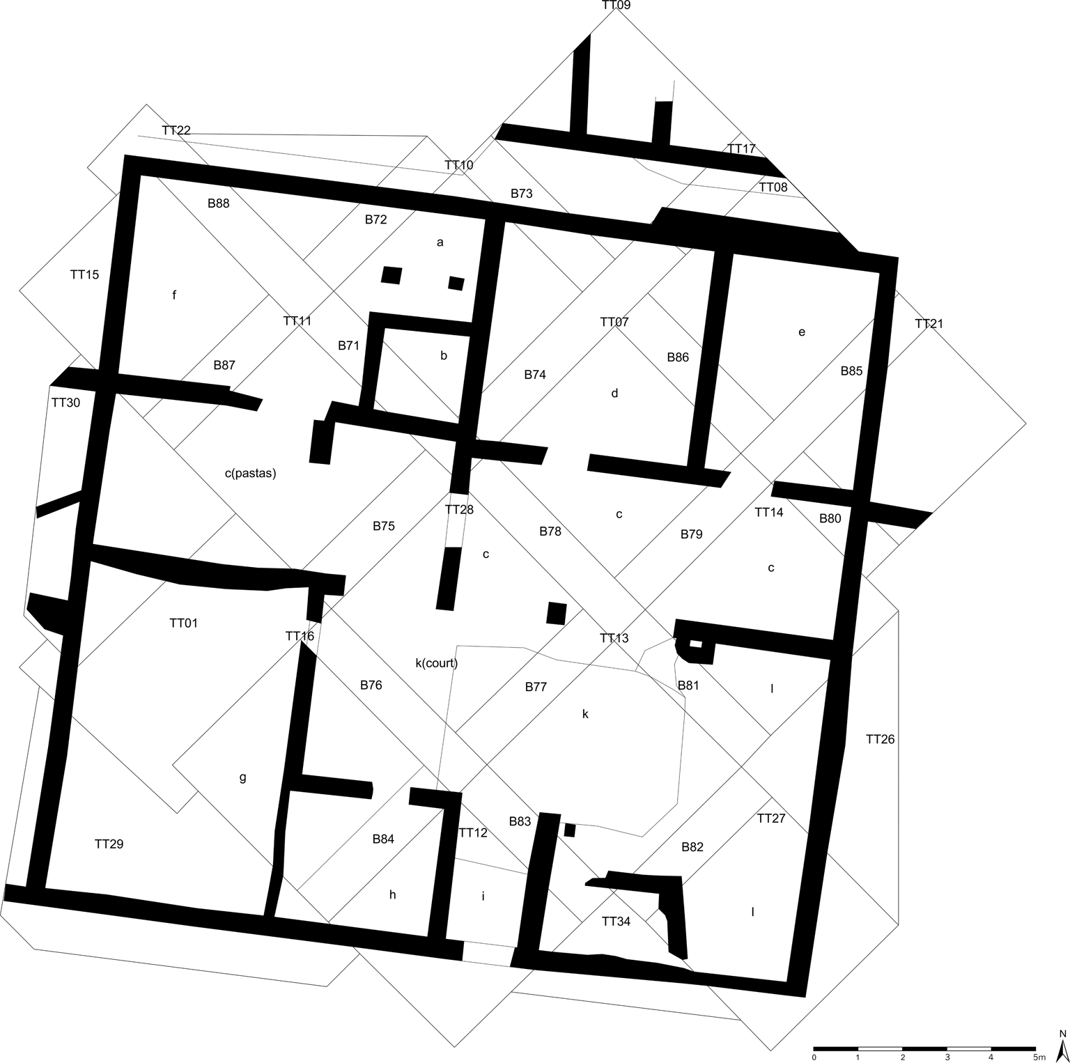
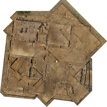
On the North Hill, the excavation of a single house, B ix 6 (using Robinson's numbering system), which is located close to Robinson's open area excavation, has been aimed at recovering as detailed a picture of household activity as possible, based on modern excavation methods (Figs 18 and 19). By the end of the 2019 season the walls had been completely revealed following the excavation of 19 trenches and the removal of the intervening baulks.Footnote 38 The house was first identified based on the Olynthos Project's geophysical data in 2014, and was selected for investigation because it appeared to have many of the architectural and organisational features already identified by Robinson and Graham (Reference Robinson and Graham1938). While most of B ix 6 was relatively well preserved, the shallow depth of soil on its southern and south-eastern boundaries meant that the socle was partly destroyed and floors were difficult or impossible to detect in these areas. During excavation, the surviving final occupation floors were identified macroscopically and the construction history of the building was investigated in selected locations. Although further analysis of the data is planned for future study seasons, we are now in a position to offer a preliminary sketch of aspects of the overall pattern of organisation, which we will continue to test, revise and develop.
Sketch plan of house B ix 6 North Hill (Filippos Stefanou).

Photomosaic of house B ix 6 North Hill (Filippos Stefanou).

Previous attempts to understand the range and spatial organisation of domestic activity in Greek houses, both at Olynthos and elsewhere, have relied on the evidence of architecture and, to a lesser extent, the distribution of artefacts (cf. Nevett Reference Nevett1999, 53–79; Cahill Reference Cahill2002, 74–288; Ault Reference Ault2005, passim). These sources can be used in the context of house B ix 6 alongside new forms of scientific data designed to provide more independent strands of evidence and to detect additional forms of activity. As examples, we offer here interim results of the analysis of microdebris recovered from the heavy fraction of bulk soil samples during flotation, and of the pilot analysis of soil samples from macroscopically identified earth floors.
Architectural evidence (LCN)
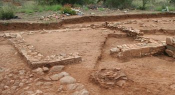
Work from 2014 to 2016 revealed that the house was organised around a cobbled courtyard, with a pastas to the north and a range of rooms behind (Nevett et al. Reference Nevett, Tsigarida, Archibald, Stone, Horsley, Ault, Panti, Lynch, Pethen, Stallibrass, Salminen, Gaffney, Sparrow, Taylor, Manousakis and Zekkos2017, 173–84). Based on our work between 2017 and 2019, we can now say that the house had one, and probably two, entrances from the street on its south side. The main door led through a centrally located corridor (i) into the cobbled courtyard (k). A large space at the south-western corner of the house (g) probably had a separate street entrance, although it is difficult to be certain because the walls defining its southern (street) and eastern boundaries are poorly preserved. We tentatively compare space (h), which lies between (g) and the entrance, with the andrones described by Robinson and Graham. No mosaic or cement floor was located here, even though excavation was continued in one part of the space (TT16) until the euthynteria was clearly exposed. Nevertheless, the use of ashlars on the walls facing the street, entrance corridor and courtyard draw attention to the space, while the doorway is off centre (Fig. 20). Its overall dimensions are just about consistent with the bottom of the range of those that Robinson and Graham identified as andrones based on the presence of a more typical cement or mosaic floor.Footnote 39 To the east, on the other side of the main house entrance (i) was an L-shaped space (j and l) which may have been roofed, but not walled off from the courtyard. While the walls and floor are not well preserved across much of this area, its southern branch was apparently extended northwards into the courtyard after the house's initial construction, sealing a cache of 51 loom weights under the latest floor. (The total of 27 excavated in 2019 can be added to a further 24 already lifted in 2016.)
Photograph of house B ix 6 space (h) viewed from the north showing ashlars in the stone socle facing into the court (Lisa Nevett).

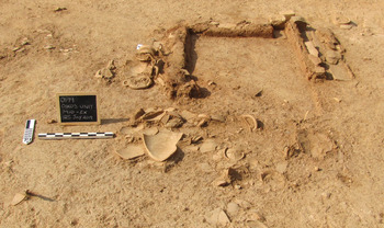
In the northern part of the house, one of the main foci of investigation during the past three years has been a large space (f) comparable to those identified by Robinson and Graham as the ‘kitchen' (Robinson and Graham Reference Robinson and Graham1938, 185–8) and later as the principal room of the ‘oecus unit’ or main living space.Footnote 40 At the centre of (f) is a pi-shaped structure composed of panels of fired clay supported on a core of soil and tile, and placed directly on what we identify macroscopically as a surface, based on the extensive destruction deposit resting at this level (Fig. 21). Although previous work at Olynthos and at other contemporary sites in Halkidiki has sometimes identified hearths in comparable locations,Footnote 41 there was no trace of burning and virtually no ash or charcoal associated with the structure in B ix 6.Footnote 42 Furthermore, this feature is different from the others in that it is rectangular, rather than square, is open at its north end and has a narrow opening at the south end that was blocked with a cube-shaped stone. Multi-element analysis of soil samples and residues from fragments of the sides is planned, in an effort to determine what the role(s) of this feature might have been.
Photograph of the pi-shaped feature in space (f) showing the surrounding destruction debris (Laurel Fricker).

Artefact distributions (BAA)
Comprehensive recording of both complete and fragmentary artefacts found within the house encompasses items such as loom weights, iron and bronze nails, and coins, but by far the most numerous category is ceramics. When study of the individual objects has been completed, the distribution of different artefact- and vessel-types will be examined systematically using the Project's Geographic Information System, to isolate spatial patterns which can then be tested statistically. Here we illustrate the kinds of patterns we are looking for with two examples that we have observed anecdotally in the distribution of ceramics.Footnote 43 In space (f), the central feature described above was surrounded by ceramic vessels. Some of these may originally have rested on its broad rim. They include two lopades, a strainer and a reddish slipped but otherwise undecorated bell-krater, which were associated with other, more fragmentary, vessels and a deer antler. An unusually large number of small whole or nearly complete vessels and implements recovered at the northern end of the structure suggest the possibility that there was a shelving unit located here. These vessels include, in fine-ware, the red-figured hydria, squat lekythos, epichysis and two olpai already discussed above, as well as two salt cellars, an incurving-rim bowl, a miniature pyxis, a lamp, the base of a stand and the handle of a ladle. To these should be added a medium-ware hand-made tray. There were also 5 kg of amphora fragments from one of the clusters of contexts which yielded this material (C15027).Footnote 44 Together these vessels suggest that, even if the terracotta structure was not used directly for heating food, it may have had some related purpose, given the range of food-related ceramic shapes found around (but not in) it, at the time the house was destroyed.
A second example is the distribution of the red-figure lekanis lids discussed above. One group of these, together with fragments of bowls probably associated with them, was distributed between the eastern half of space (c) and space (e). Two knob handles come from (c) and the rest of the lid and bowl fragments from (e). Fragments from a second group were distributed between space (f) and the neighboring space (d). The distribution of these lekanides across four separate spaces suggests that they fell from upper storey rooms which once lay above the northern portion of the house, and begins to provide some insight into the nature of the activities taking place upstairs in the house at the time of the destruction.
Microdebris evidence (BH, ES)
Variations in the amount and proportion of different types of material in the heavy fraction yielded by flotation offer an indication of the habitual breakage and discard patterns across different spaces, and hence a means of exploring the long-term use of those spaces. Within house B ix 6, there are differences both in terms of the density and the type of artefact recovered. The flue and the two rooms straddling the entrance, (h) and (l), show a broader range of artefact types than the rest of the house. Room (h) also included relatively high quantities of fine-ware (0.7 pieces per litre of soil sampled, compared to 0.2 in space (g) and 0.3 in the west pastas), while the western part of the courtyard in front of it had high densities of medium-ware.
Analysis of gridded soil samples (CL, JAM, JJG, AlP, CV)
Although architecture, artefacts and microdebris are all valuable in building up a picture of domestic activity patterns, none is ideal in terms of the level of resolution offered (for discussion, see Nevett Reference Nevett, Raja and Lichtenbergerin press). The Project has therefore sought to investigate the effectiveness of a range of additional techniques which provide further strands of evidence through which patterns of domestic activity can be explored. Here we discuss the results of a pilot study of soil samples taken from the house floor in the southern part of room (d) and part of (c) (the pastas). A total of 26 samples from contexts C7014 and C7015 were selected (Fig. 22). Each one was processed for combined phytolith and starch extraction, geochemical multi-element analysis, and spot tests, following standard laboratory procedures (Madella, Power-Jones and Jones Reference Madella, Power-Jones and Jones1998; Horrocks Reference Horrocks2005; Barba Reference Barba2007; Pecci, Barba and Ortiz Reference Pecci, Barba and Ortiz2017; Rondelli et al. Reference Rondelli, Lancelotti, Madella, Pecci, Balbo, Ruiz Perez, Inserra, Gadekar, Cau and Ajithprasad2014).
Location of samples analysed within contexts C7014 and C7015 (Carla Lancelotti).

Preliminary results of the micro-remains analyses show generally poor preservation of botanical micro-remains. Starch was present, though not abundant, in five of the 26 samples analysed. The absolute majority of starch grains was identified as ‘Panicoidaeae type’, indicating the presence of C4 grasses at the site (i.e. grasses well adapted to arid and hot climates). A few other grains belong to the Triticeae tribe, to which wheat and barley belong. Finally, one starch granule was identified as belonging to an unidentified tuber. Noteworthy was the fact that almost all the starch grains were recovered from context C7015, the south-west corner of space (d), which was less enriched in fatty acids and proteins (see below). Phytolith preservation was unfortunately extremely poor in all samples. Analysis has shown no identifiable morphotypes in any of the samples analysed.
Preliminary statistical analysis of the geochemical results showed minimal differences between the two contexts under study. The similarity in the composition of the floor surfaces allows us to consider that any differences can be attributed to a differential use of the space. It is interesting to note the statistical difference in strontium (Sr) concentration (higher in C7015 than C7014) and the almost total absence of sodium (Na), below the detection limit in the absolute majority of the samples. Strontium-enriched sediments tend to be associated with the preparation of particular foods rich in this element, such as dairy products, leafy greens, legumes and fish, or with sea salt (Wright Reference Wright2005), although the virtual absence of sodium leads us to exclude legumes and sea salt, and further analyses (i.e. organic residue analysis) could help in a better understanding of the origin of the substances that fell on the floor.
Spot test results show a high degree of variability, which might indicate the presence of different activity areas, some of which are enriched with substances rich in fatty acids, protein residues or phosphates. However, the area analysed is too small to understand the distribution of activities at household level or to make strong interpretations on the use of the spaces analysed. In general, C7014 – the pastas – seems to be more enriched than the south-west corner of the space (d) (C7015) (Fig. 23), which is a common pattern at an ethnoarchaeological level. The concentration of fatty acids and so called ‘protein residues’ (Barba Reference Barba2007) in C7014 could be related to food processing that could also have been carried out inside room (d), where fatty acids and phosphates are present. However, further analyses of the whole area are necessary to confirm this hypothesis.
Ordinary kriging maps of distribution of organic residues (Carla Lancelotti).

The geostatistical analyses of these preliminary results focused on the multi-element chemical data. We applied a Linear Discriminant Analysis (LDA) classification method on ordinary kriging interpolations, whereby we assigned a class predictor to each sample based on prior knowledge (starch and spot tests results). We arbitrarily assigned the samples to one of these categories (Fig. 24) and used an RGB visualisation to check the posterior probability that each of the samples belonged to the assigned category (Fig. 25). The results showed that there is a difference between the two spaces created by the east–west wall, but that also the samples pertaining to a single space (C7015) fall into two different categories, roughly distinguishing three different activity areas. By comparison with ethnographic modeling (Rondelli et al. Reference Rondelli, Lancelotti, Madella, Pecci, Balbo, Ruiz Perez, Inserra, Gadekar, Cau and Ajithprasad2014), C7014, the area predominantly blue in Fig. 25, was interpreted as a covered, open space, which agrees with its identification as the pastas.
LDA plots and location of grouped samples (Carla Lancelotti).

Visualisation in RGB based on the posterior probabilities computed by the model with regard to each category (Carla Lancelotti).

Architectural and functional variety on the North Hill: non-residential activities (ZHA)
Geophysical data (from electrical resistance and magnetic surveys) collected in 2014, on the north-east periphery of the North Hill, indicated a wide band of features that did not conform to the orthogonal grid that is so well documented further south, towards the centre of the hill. Trench TT03 (3 × 6 m) was opened in 2014 in order to follow up one of a number of anomalies that attracted attention within this sector. The north-east to south-west orientation of the walls here contrasts with the prevailing north–south orientation of the regular insulae. It was concluded that this area had been designed as an independent focus of non-residential activity, perhaps of an industrial nature, but with some evidence of deliberate deposition in the form of a series of superimposed vessels below a ring of stones (Archibald in Nevett et al. Reference Nevett, Tsigarida, Archibald, Stone, Horsley, Ault, Panti, Lynch, Pethen, Stallibrass, Salminen, Gaffney, Sparrow, Taylor, Manousakis and Zekkos2017, 169–71, with figs 6–7).
TT03 was extended to the north-west in 2018 (TT31) and more than trebled in size in 2019, with partial extensions to the west, south and east, forming a compact series of combined trenches (TT03, TT31, TT32, TT33 and TT36) either side of TT03. The compact area of the combined trench extends 9 m (north–south) by 6 m (east–west). The area exposed revealed a lattice of partially preserved, partially collapsed walls (Figs 26 and 27) associated with what appear to be non-residential, perhaps productive, activities. The structure alongside the over-sized pithos (C3017) in TT03 appears in plan as a H-shaped set of shallow stone foundations, with one complete exterior wing on the west side and a partial wing parallel to it on the east side. Along with two ephemeral post impressions, it creates something akin to a di-style chamber and antechamber in antis. The suggested outline of the structure identified seems further to be confirmed by another wall (C3020–C32004–C36004), immediately north-east of the pithos, lying perpendicular to the H-shaped construction, but broadly aligned with its westernmost surviving extension. This implies that the pithos was intended to be at least partially protected by a roof. The quantity of tile retrieved from the excavation is nevertheless rather limited.
Photograph showing the trenches in the northern area of the North Hill (Zosia Archibald).

Plan of the trenches in the northern area of the North Hill (Filippos Stefanou).

Expansion of the excavated area revealed three further walls, running approximately north-west to south-east, and thus in broad alignment with the H-shaped construction. In plan and elevation, these walls all appear to be related. The easternmost of these walls (C32005–C32017) suffered a catastrophic collapse, with its structural matrix of sub-rounded cobbles of different lithology falling mainly along its northern end, so that parts of its entire mud-brick and stone superstructure were found buried above a thick, mixed deposit of stones, calcareous plaster and a few tile fragments. The southerly section survived in three courses. The collapse filled the putative cellar of a room adjacent to the pithos, at a depth of a metre below the modern ground surface, and at some depth below the lowest course of C32005. It is possible that the pithos was installed at the same level as this cellar floor. The foundation course of wall C3007–C31004, which was identified in 2014 as the deepest feature in TT03, also corresponds approximately to the cellar floor in depth.
It seems that this complex of walls corresponds to several phases or sub-phases of construction, beginning with a rather fine, compact wall (C3007–C31004), built by experienced masons, approximately 1 m below the modern ground surface. Subsequently, the space south and east of it became a cellar, with stone wall foundations raised from a higher ground surface, to the east, with the pithos inserted around the time that the cellar was in use as a storage area.
The precise relationship between the earliest activities, the functioning of the cellar, the collapse of its south-eastern wall, the subsequent reuse of the pithos, and the reuse of the structure containing the deposit found in 2014 (the successive floors of which are higher within the stratigraphy) requires further study. A small but persistent scatter of metallurgical waste fragments, the upper part of an Olynthos-type mill found at the western limit of this structure in 2018, fragments of other grinding stones and the exceptionally large size of the pithos all point to agriculturally related activities.
The overall profile of ceramic finds seems, on preliminary examination, to be sufficiently different from house B ix 6 to suggest that further analyses will help to define this sector more clearly. The percentage by weight of coarse-ware items was noticeably higher than in house B ix 6 (at 21 per cent compared with 9.63 per cent), while medium-wares were somewhat lower than in the house (38:51.52 per cent). Closer study will show whether or not these differences are significant. Cooking-wares and storage-vessels dominated the lower contexts in the excavated sector, while fine-wares, including black-glazed bowls and cups, as well as the base of a red-figure bell-krater, were located in the upper deposits. Among the finds of note were several iron knives, a possible spear head, a lead sling shot, loom weights, fragmentary terracotta figurines and a well-preserved copper alloy trilobate arrowhead.
Profiling the urban economy (LCN)
A range of survey and excavation data can be used to consider aspects of the Olynthian economy, including: the sourcing of ordinary commodities such as those used in house-construction; subsistence practices; and the distances travelled by some of the goods that households consumed. Many of these topics can be addressed using data-sets already discussed above in other contexts: for example, consideration of faunal evidence is an important tool for understanding subsistence practices, while imported ceramics offer a means of assessing the scale and direction of trading links. Here, we discuss additional examples of data which can be applied to consideration of some economic questions, namely: aspects of the use of basic commodities in activities such as house construction, including the evidence of roof tiles; subsistence practices as revealed by archaeobotanical evidence; and the sourcing of goods as suggested by the transport amphoras studied so far.
Understanding the deployment of basic commodities (ZHA)
Olynthos had one of the largest territories of the pre-Hellenistic age, according to the most recent comparative studies; the area under its control in the late fifth century bce is suggested as being c. 630 km2, and ‘in the 380s much larger’ (Flensted-Jensen Reference Flensted-Jensen, Hansen and Nielsen2004, 834, no. 588). The study area included in the Olynthos Project does not allow for full consideration of the topographic implications of such projections, although the political and economic ramifications will be accounted for in our future analytical studies. Using the broadly drawn yardstick of city-size compiled by the contributors to the Inventory of Archaic and Classical Poleis (Hansen and Nielsen Reference Hansen and Nielsen2004), we might expect to see evidence of personal and collective wealth and of a high standard of living, analogous to what is found in Athens, Corinth, Syracuse or Pantikapaion. Excavation has revealed only very limited aspects of urban wealth, as expressed in the quality of materials and of movable property. Robinson's excavations demonstrated the high specifications for residential units on the North Hill, and house B ix 6 reflects precisely what this meant. Many of the materials used for construction were readily available, or could be found within comparatively short distances of the two hills (clay for brick-making; river stones for foundations).Footnote 45 Although only parts of houses have been investigated on the South Hill by the Olynthos Project, these nevertheless provide important information that supplements the data provided by geophysical survey. Any consideration of the labour of construction cannot avoid the key role of tools used in these processes. Most of the iron tools that were used at Olynthos have not survived the rapid corrosion that destroys this metal.Footnote 46
The arguments presented above concerning the sizes of households at Olynthos have consequences for the population of the city as a whole, and for the ways in which we imagine the city's florescence in the mid-fourth century bce. A population of 4000 is more-or-less consistent with estimates for the period 480–432 bce, but not for subsequent decades, until Olynthos’ military defeat in 348 bce and its subsequent demise. By the middle of the fourth century bce, this figure is usually thought by historians to have doubled (Diodorus Siculus 16.8.4; Flensted-Jensen, Reference Flensted-Jensen, Hansen and Nielsen2004, 834 with discussion). Scholars will need to reconsider the relationship between the urban nucleus identified as the heart of the city and its wider material domains. If the territorial reach of the city was as large as historical evidence implies, then a proportion, perhaps even a sizable one, of its citizens, dependents and their retainers will also have been distributed outside the urban nucleus.
Roof tiles (EC)
The sources and manufacturing techniques used to produce roof tiles provide important evidence for some of the economic aspects of house construction. A large number of ceramic tile fragments have been collected during the Olynthos Project's excavation and surface survey on and around the hills of Olynthos. (As an indication, the excavations alone have unearthed a total of 56,739 fragments with a weight of about 3,565,214 kg) The majority of the tiles date to the Classical Period, while there are some that probably point to earlier or later dates. So far, all the tiles in the assemblage seem to belong to the ‘Lakonian style’, with wide, concave pan tiles and convex cover tiles, both tapering in width from one end to the other. One fragment of a tile with opaion was found in the field survey in the Lower City. Opaion tiles are pan tiles with an opening in the centre, surrounded by a raised rim. They served to let smoke out and to bring light and ventilation into the room.Footnote 47 Other examples of this type were found in House A viii 8, A viii 10, the House of Many Colors (Robinson Reference Robinson1946, 49–50, 56, 186, pl. 38:6–7) and in houses in Olynthos’ port town, Mekyberna (Mylonas Reference Mylonas1943, 85). No tile of the ‘Corinthian style’ or any associated antefix, like those published by Robinson (Reference Robinson1946, 91, pl. 84, 186, pl. 208), has been found by the project. These were most likely to have been used on the roofs of public buildings, while the ‘Lakonian-style’ tiles were used on private roofs and in tile-covered graves (Robinson Reference Robinson1942, 158).
The condition of the roof tiles from the excavation is often very fragmentary (the dimensions are mostly between 10 and 30 cm), and no tile has been found so far that is preserved along its entire length. A few partly restored examples have shown that the widths of the tiles are not absolutely uniform, but they are similar to those published by Robinson (Robinson and Graham Reference Robinson and Graham1938, 232, fig. 17ab). The top end of the cover tiles in the assemblage measures 18–19 cm and the bottom end 23–5 cm. The bottom end of the pan tiles measures 44–5 cm and the top end 51–3 cm. The upper sides of the tiles are slipped, ranging in colour from a red, through reddish brown, to black, probably depending on the firing conditions in the kiln. Finger-line marks are often present on the lower sides. These are either related to the forming of the tiles or they served to ensure a steady installation on the roof. There is one example of a stamped tile and one inscribed tile in the assemblage. Paw prints are present on a few tiles and even one human hand imprint.
The large number of houses built on the North Hill to accommodate the increased population from 432 bce and the consequent increase in demand for roof tiles raise many questions about the ceramic building economy. For example, was the production of tiles locally organised, or is there evidence that non-local resources have been exploited, perhaps indicating a movement of ceramics or even their importation?Footnote 48 How specialised was the production of tiles compared to the production of other ceramic wares?Footnote 49 So far, several tile fabrics have been identified through the application of two ceramic compositional analyses: portable X-Ray Fluorescence spectrometry and thin section petrography (for examples, see Fig. 28).Footnote 50 The analysis of the fabrics is still in progress but already reveals several aspects of the acquisition and processing of the clays and the firing of the tiles (for example: the possible provenance of the clays; the use of clay mixing and tempering; and specific firing conditions).
Examples of tile fabrics from Olynthos (Elena Cuijpers).

Archaeobotanical evidence (EM)
The aim of the archaeobotanical analysis is to reconstruct plant consumption, processing and storage practices. The activities involved will eventually be placed within their spatial and chronological contexts within the city, evaluating their significance for the economies of the different households and districts represented in the samples. Here we summarise preliminary results from the study of samples collected by the Olynthos Project from 17 different trenches, mostly from the structures located on the North Hill and the streets on the South Hill.Footnote 51
A total of 194 archaeobotanical samples deriving from various contexts were scanned (Fig. 29). All botanical items under consideration here are preserved by charring. The remains were relatively badly preserved and were often fragmented. Due to their hardness and heaviness, nutshells and fruit stones were better preserved than grains, and were mostly recovered in the heavy fraction. Here we discuss the assemblage from trench TT23, which can be considered as representative because it contains more than a hundred items (seeds, chaff, nutshells and floral parts).
Synthesis of archaeobotanical samples from Olynthos 2017 and 2018 (Evi Margaritis).

The assemblage can be divided into three parts: a third (36 per cent, nmi = 43) consists of crops including cereals and pulses; another third (31 per cent, nmi = 37) is made up of fruits; and the remaining third (34 per cent, nmi = 41) consists of wild or weed taxa, including small grasses and small legumes. There is also a range of unidentified or unidentifiable remains, as well as amorphous residues that could be the remains of food and/or dung.
Among the three categories (Fig. 30), cereals were represented by the caryopses of indeterminate specimens (Cerealia spp.), hulled barley (Hordeum vulgare), glume wheats (Triticum dicoccum and T. monococcum) and naked wheat (Triticum aestivum durum). A single glume base of emmer (Triticum dicoccum) has also been identified. Pulses are dominated by lentil seeds (Lens sp.), but grass pea (Lathyrus sp.), bitter vetch (Vicia ervilia) and indeterminate specimens including Viciaceae (Pisum/Vicia/Lathyrus) have also been identified. The fruit category is to a large extent dominated by the remains of olive stones (Olea sp.), mostly in fragmentary form. The importance of this emblematic Greek taxon is demonstrated by both the number of finds and also their ubiquity (the number of samples in which such remains are present). A total of 125 fragments, as well as six half and two whole fruit stones have been encountered, and the taxon is present in 26 samples, meaning 37.1 per cent of samples from trench TT23. Fruits are also represented by fig achenes (Ficus carica), grape pips (Vitis vinifera) and unidentified remains including nutshell fragments.
Archaeobotanical composition of the assemblage from TT23 (Evi Margaritis).

The wild or weed taxa – many probably coming as contaminants or as part of dung fuel – are mostly represented by small grasses, including Phalaris sp. and Stipa sp. grains. Small legumes (Astragalus/Trigonella and Melilotus/Trifolium) could not be identified to the genus level. Other wild plants such as the Artemisia type, and the Chenopodiaceae and Liliaceae type, require further analysis with the help of an enhanced reference collection to be securely determined.
Despite a majority of identifications to the family or genus level, plants recovered in the TT23 assemblage may reflect various environmental conditions surrounding the archaeological site of Olynthos. Artemisia sp., Chenopodiaceae and small legumes may, for example, represent dry environments, while Phalaris sp. and Cyperaceae can be indicative of a moister habitat such as a riparian vegetation.
Additionally, the numerous (n = 48) and ubiquitous (ub. = 15, fr. = 22 per cent) amorphous residue fragments may derive from human processed food and/or animal dung used as fuel for domestic activities. It is interesting to note that a single area yielded not only fragmentary olive stones, but also pine nuts and sesame seeds, these last two identified nowhere else at Olynthos.
Transport amphoras (CT)
Analysis of the transport amphoras can contribute to our understanding of the dynamics of imports into Olynthos, as well as consumption patterns in the city as a whole and in its different districts. Systematic study of transport amphoras from the Olynthos Project started in 2016, and up to 2019 (the period covered here) it has focused mostly on finds from the field survey. The amphora material has so far been processed from 110 out of the 253 surveyed grids within the intramural area of the ancient city, and 663 out of the 1780 surveyed fields in the immediate hinterland.Footnote 52 The total area of these fields is 3728 km2. From the material collected in this area, a sample has been selected comprising fragments that provide information about date or provenance, and/or allow the number of individual vessels to be estimated. These include all fragments, the total count of which is 322, from rims, handle attachments and toes.
This sample represents between 74 and 322 complete vessels,Footnote 53 which, at first glance, is a surprisingly small number, given the extent of the area from which it is collected. Most fields in the hinterland yielded very few amphora fragments or none at all. This contrasts with the intramural area, where the average density of amphoras is over 20 times higher. More detailed consideration of the density of amphora finds would require factors such as survey methods and surface visibility to be taken into account, and this will be done when all of the material has been processed.
In terms of chronology and provenance, the sample of amphoras from the survey appears homogeneous, showing no difference between the intramural area and the hinterland. The majority of the 67 datable fragments belong to the late fifth and fourth centuries bce. Only seven are certainly earlier than 400 bce, and none can be dated with certainty after the destruction of Olynthos in 348 bce. About 83 per cent of the fragments of identifiable provenance are from the North Aegean, most of them from the area of Halkidiki. Toes and rims of Mendean-type amphoras in particular form more than half (54 per cent) of all recognisable fragments (Fig. 31). The rest of the finds include fragments of mushroom rims and knob toes from the south-east Aegean (13 per cent), alongside a few pieces from Thasos, Chios and Erythrai. The survey yielded four stamped fragments; only two such fragments were found during excavations, both of them of unknown provenance and date.Footnote 54
Amphora toe types commonly found during the field survey in the area of Olynthos (Chavdar Tzochev; scale in cm).

This picture is consistent with published data from Robinson's excavations. He reported only 28 stamped handles and two complete vessels (Robinson Reference Robinson1950, 25, 201–2, pl. 146, 257–62). Fragmentary amphora material was not included in the Olynthos volumes, but a short note mentions a single large deposit of 630 broken amphoras found near the Public Fountain (Robinson Reference Robinson1946, pl. 91, fig. 1; 1950, 18). A photograph illustrating this deposit shows a pile of amphora fragments, most of which appear to be fourth-century bce stem toes of the same Mendean types dominating the material collected by the Olynthos Project.
If any conclusion can be drawn at this stage of the study, it is that Olynthos appears rather isolated in terms of amphora imports. The great majority of containers came from nearby places in Halkidiki, and the overall quantities look unimpressive for a city in the North Aegean. The relatively short existence and the abandonment of the city in the fourth century bce account for these observations at least to some extent. For example, it is easy to explain the paucity of stamped fragments by the fact that stamping amphoras became a regular practice only after the beginning of the fourth century bce. By the time Olynthos was destroyed, only two cities were stamping their amphoras systematically. One of them, Heraclea Pontica, was virtually unknown in Aegean markets; the other, Thasos, exported almost exclusively to the Black Sea during the period in question (Tzochev Reference Tzochev2016, 95–6). This also explains why there are so few Thasian amphoras at Olynthos: simply, the city was ruined before Thasian wine became popular in Macedonia.
The high percentage of local, Halkidikian, amphoras makes sense in the context of well-developed traditions of viticulture and amphora-making in the area, and of the presence of a renowned wine exporter – the city of Mende – located just a few hours sailing or walking distance from Olynthos. While the most common amphora shapes attested at Olynthos are traditionally termed ‘Mendean’, they are really part of a regional potting style that spreads beyond Mende and the Kassandra peninsula and is not yet well understood (Filis Reference Filis and Kotsou2012, 63, 67–71; Reference Filis, Manakidou and Avramidou2019, 250–3). Thus, distinguishing the products of different amphora workshops in Halkidiki emerges as a major challenge for this study, and for understanding the Olynthian economy in general.
The challenge of connecting the local and the global in the economy of Olynthos (ZHA)
The preliminary analysis of transport amphoras (above) shows that some of the assumptions that historians and archaeologists have nursed about what was typical of a Classical city must be revised or reconfigured. Olynthos was manifestly a significant city; its historical role, as well as its territorial reach, make this unquestionable (see Flensted-Jensen Reference Flensted-Jensen, Hansen and Nielsen2004, 834–6). Yet the expectation that we have of material manifestations of this importance must be rethought. The history of Olynthos is closely bound up with the history of the Halkidic peninsula as a whole, and with the wider Aegean world, including some of its most illustrious players – the Athenians, Spartans, Macedonians, Thessalians and Boiotians. The material retrieved by the Olynthos Project gives little hint of this outreach, and transport amphoras, which usually constitute a useful indicator of at least some external partners (as well as items transported by middlemen), point instead to the circulation of vessels and liquid or dry foodstuffs in and around the peninsula.
In order to calibrate the gap between the local, Halkidikian economy, and its wider outreach, we must look elsewhere. The city's diplomatic history offers an obvious resource, but so too can a renewed look at the coins accumulated during Robinson's project. These have recently been restudied by Cahill (Reference Cahill2002, 266–73), Davies (Reference Davies2016, 30–3), and Gatzolis and Psoma (Reference Gatzolis and Psoma2016, 83–9). These authors have underscored the importance of the legacy numismatic data for comparative purposes, as well as for various specific analyses. Here I want to draw attention briefly to the potential of coin data for our understanding of the city's wider economy in time and space. The Olynthos Project has retrieved 25 copper alloy coins, all but seven of which were found close to, or at, floor level in house B ix 6. The coins identified from the floor of the house are exclusively local issues and illuminate exactly what we mean by ‘small change’ in the context of domestic expenditure. These losses suggest that the supply of these low value coin types was comfortable. Of the remaining coins, two were recovered from the field survey, and of the other five, three were from trenches on the South Hill, and two from other trenches on the North Hill. One coin from house B ix 6 (T10002) was from the neighbouring city of Akanthos, which represents an unresolved problem in the city's history. Akanthos was not a member of the Chalcidian League, and the 102 coins of Akanthos found by Robinson's team remain hard to explain (Gatzolis and Psoma [Reference Gatzolis and Psoma2016, 89] think that these simply represent political realities). It is notable that not one single coin in precious metal was recovered, even from flotation samples. Higher value coins were evidently kept safe and secure.
Nevertheless, we do need to consider the significance of absences from the excavation record of the Olynthos Project, particularly the absence of non-Chalcidian issues. ‘Foreign’ coins, that is, coins that were not minted by the political authority in place, are a difficult data-set to explore, precisely because modern scholars usually lack information about the status of such money within the local economy.Footnote 55 Robinson's team were more successful in discovering ‘foreign’ coins. Although ‘foreign’ coins were normally delivered by visitors, these visitors were not random tourists. Travellers operating over large distances were investing in such enterprises, and taking considerable risks. They normally had particular reasons for coming; closer analysis of these coins may help us to understand the interface between commercial transportation and political or cultural objectives, which often have an economic dimension as well. The historic role of the Macedonian kings, and their close interest in Olynthos, is written in the numismatic evidence, beginning with Alexander I and ending with Antigonos Gonatas, long after the city itself had ceased to be physically inhabited. In all likelihood, the reasons why the later royal issues are found here is connected to the strategic importance of the city's farmland and resources, notably its access to timber reserves, as well as to mines (iron and copper reserves). Whilst the city was active, Macedonia's kings ensured that they formally reserved the right to limit access to strategic ship's timber for triremes, but Olynthos and its neighbours were free to exploit other timber reserves (see most recently Karathanasis Reference Karathanasis2019).
The value of timber in Halkidiki was considerable for communities that lacked wood suitable for productive purposes, not just for the construction of triremes, but also for various pyrotechnological ends such as the manufacture of weapons, armour and other large metallurgical commissions, including statuary (Archibald Reference Archibald, Archibald and Haywood2019, 177–94). This may well explain why we find some rather distant communities represented among the silver and copper alloy issues at Olynthos. The range of coins from outside the Halkidic peninsula has not received the attention that these items deserve. A total of 4638 coins was recorded by Robinson's team, of which 3480 copper alloy issues were registered in excavated contexts, out of a total 4237 copper coins (Cahill Reference Cahill2002, 266; Gatzolis and Psoma Reference Gatzolis and Psoma2016, 85). There were 399 silver coins. The most common coins at Olynthos are the copper alloy small denominations that are explicitly inscribed as belonging to the Chalkidians (2489), or to the Bottiaians (322), or can be attributed to either community by type (177: Gatzolis and Psoma Reference Gatzolis and Psoma2016, 84, table 1). Most of the 25 coins that were excavated by the Olynthos Project can be identified as belonging to these types. These items of small change would have been used in standard market transactions, and Cahill has explored the proximity of coined money, including silver, in excavated houses, to the agora (Cahill Reference Cahill2002, 266–8, fig. 60).
Foreign coins do not fit this neat topographic arrangement. Yet these include issues from further along the North Aegean coast (Amphipolis, Abdera, Ainos, Maroneia, the Thracian Chersonese), as well as many individual civic communities in Thessaly, Illyria, Euboia, the Argolid, the Cycladic Islands, Bithynia, Mysia, Ionia, the Persian Empire, as well as the more predictable hubs of commerce, Athens and Corinth. We also find the Odrysian kings of the two middle quarters of the fourth century represented: Hebryzelmis, Kotys I, Kersebleptes and Ketriporis (Gatzolis and Psoma Reference Gatzolis and Psoma2016, 83–4, table 1). These extensive contacts need to be explained. At Athens and Corinth the range of coins found overlaps at least in part with the range of transport amphoras recovered, reflecting these cities’ status as entrepôts and as re-exporting centres. This is not what we find at Olynthos, and a different explanation must be sought.
CONCLUSION (LCN AND DLS)
Analysis of the evidence gathered by the Project is still ongoing, so discussion here is preliminary. Nevertheless, it is already clear that our knowledge of Olynthos has been extended well beyond the picture that David Robinson was able to provide, which was already comparatively detailed. For Robinson, the only means of evaluating what lay buried under the soil was to dig narrow trenches for long distances across the site, which he explained as a means of searching for ‘any important building which might be there’ (Robinson Reference Robinson1930, 5, with reference to trench 4 on the South Hill), but which must also have furnished information about the extent of the inhabited area.Footnote 56 Today the orientation of research has shifted, with new questions stimulated by a different intellectual environment, the focus moving away from a search for specific types of structure. Instead, the goal has been to achieve as complete a profile as possible of the overall urban environment, while at the same time looking at selected areas in unprecedented detail to answer questions about chronology, the economy and society. These new goals have been supported by an increased range of investigative techniques, albeit such methods yield information of varying kinds and levels of detail.
As noted above, Olynthos as a whole covers an area of 50–60 ha, of which Robinson excavated at least 7.5 ha, or approximately 15 per cent of its total area. With the benefit of the new goals and methods of the Olynthos Project, we are now able to speak with increased confidence and precision about the character of the urban plan and some of its component buildings, as well as about the density of occupation in different districts. Slow, stratigraphic excavation of about 450 m2 means that we now have a better understanding of the chronology of settlement on the South Hill, and a more detailed picture of the organisation of domestic and economic activities on the North Hill. At the same time, by supplementing excavation with geophysical survey, we have added an additional 23.5 ha to our picture of the urban plan. Finally, collection of the surface material provides information about the occupation dates and range of activities taking place over more than 50 per cent of the city (much of it also covered through geophysical survey). Digital technologies have a major part to play in enhancing our understanding: photogrammetry, the use of a total station and a differential global positioning system permits much more comprehensive and accurate recording, while at the same time gathering the data in a geographic information system facilitates their retrieval and collaborative analysis. The geophysical and survey data contribute significantly to our ability to ask quantitative questions alongside the qualitative ones to which excavation is particularly suited.
The construction of a detailed profile using the new data we have outlined here, in tandem with the coarser-grained legacy data from earlier projects, will be developed further in the final publication of the Project. Future work will involve more detailed analyses of our data that will enable us to address more complex issues such as: the degree of cultural change through time; the extent of social and cultural homogeneity across the city's districts; and the nature of economic practices within households, districts and the city as a whole. This work will ultimately contribute to wider debates concerning the nature of urbanism and the timing of urban development in Greece, as well as offering a basis for beginning to evaluate in more depth how Greek urbanism relates to the phenomenon of urbanism in other cultures.
ACKNOWLEDGEMENTS
The authors would like to thank the Hellenic Ministry of Culture, the British School at Athens, the Eforates of Pella and Halkidiki, the Universities of Michigan (Department of Classical Studies, Kelsey Museum of Archaeology and Office of the Vice-President for Research) and Liverpool (School of Archaeology, Classics and Egyptology), the American Philosophical Society, the Delmas Foundation, the Loeb Classical Library Foundation, the Mediterranean Archaeology Trust, the National Geographic Society and the Society of Antiquaries for funding and otherwise facilitating our research. The Project could not have taken place without the hard work and dedication of our numerous volunteers, nor the kindness and assistance of the staff at the Archaeological Site of Olynthos and the residents of the village of Nea Olinthos.