

The general characterization of street numbering as a strictly ‘American system’ of urban spatial organization is a historical oversimplification but not an outright misnomer. In this article, I examine the question of why the numbering of streets, whilst pervasive in North America, has remained very infrequent in Europe. On the western side of the Atlantic, the proliferation of street numbering in the nineteenth century was associated with the building of gridiron cities, on the one hand, and the introduction of the number-based systems of house and lot identification, on the other.Footnote 1 Yet, although checkerboard layouts were simultaneously a fad in the ‘Old Continent’, and its cities actually led the way insofar as the rationalization of space through house numbering is concerned, the bestowing of streets with numerical (or alphabetical) names has remained an oddity in the context of European urbanism. Given the lack of historical scholarship on this transatlantic disparity, the current study considers the historico-geographic evidence of street numbering in Europe.
Although the distinction between number-based and non-numerical street naming guides this study, it should be emphasized at the outset that these modes of spatial inscription also have much in common. In their modern institutionalized forms, both practices play the same role of unambiguous spatial identification as part of wider addressing systems and efforts to keep track of urban spaces, processes and people. As Georg Simmel notes in his Soziologie, both techniques of urban inscription ‘individualize’ spatial objects, but only the practice of numbering works through an abstracted ‘ahistorical-schematic’ logic.Footnote 2 In essence, at stake is the difference between nominal and ordinal scales of measurement: ordinary names can ‘only’ bestow landscape elements (districts, quarters, streets, buildings, etc.) with the denotations and connotations of specific words, whereas the ‘higher logic’ of numbering and alphabetical lettering is capable of imposing interval-based representational order on the landscape.
According to Simmel, the more efficient individualization by numbers has overridden conventional naming practices in many technocratic and everyday spheres in the course of modernization – the now generally taken-for-granted nature of house-numbering and postal code systems are prime examples in this respect. Yet, ‘the advent of number’Footnote 3 has been anything but absolute, as a look at the names of streets, neighbourhoods, or cities themselves on a public map from practically any part of the world immediately reveals.Footnote 4 In the street nomenclature of European cities, in particular, the persistence of non-numerical evocations of local history, nationalistic commemorations (especially in city centres) and thematic clusters of names (predominantly in suburbs) is striking.Footnote 5 Inevitably, the (ill) fate of street numbering in Europe has to be appraised vis-à-vis the predominance of these ‘other’ toponymic categories.
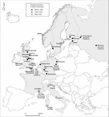
That said, a methodological dilemma met in doing this research was that the European cases of street numbering are very sporadic in both historical and contemporary terms. As such, the following mappings do not pretend to be exhaustive. Rather, the 10 national contexts that I consider were initially selected on the basis of literature and available collegial assistance.Footnote 6 In the next phase, additional national cases of numbered streets – from historically noteworthy and pivotally located ones to small and peripheral instances – were collected through map, street directory and internet searches based on language-specific combinations of specific (1, Zweite, 3e, Fourth, etc.) and generic (Street, Avenue, Gasse, Straat, Via, Gatan etc.) terms (Figure 1). As the aim was to investigate publicly used street names (and not purely technocratic identifiers employed by civil engineering departments and the like), their appearance on city maps was double-checked in due course. In analysing the material, the article's interpretations were guided by the following research questions:
A selection of European cities and towns with numbered streets.

• What types of numbered or lettered street systems have existed in the United Kingdom, Germany, Russia, France, Italy, the Netherlands, Estonia, Norway, Sweden and Finland?
• On which parts of the urban fabric have the cases of street numbering concentrated?
• In light of the documented cases, what other types of naming practices have competed with street numbering in Europe?
• What sort of factors explain the marginality of street numbering in the context of European urbanism?
In the section to follow, I will focus on three medieval and early modern ‘new towns’ – New Winchelsea, Mannheim and Vasilievsky Island, St Petersburg – known for their idiosyncratic street-numbering systems. Next, I turn to the mapping of more numerous, yet typically smaller pockets of, numbered streets given in the 10 national contexts in the modern era. In the concluding section, I draw together factors related to the characteristics of urbanization and nation-building in Europe that seem to explain the marginality of street numbering on the continent.
Three medieval and early modern anomalies: New Winchelsea, Mannheim and Vasilievsky Island
Today, it is safe to argue that not a single cluster of numbered streets exists in the overwhelming majority of European cities. However, pre-modern urban history witnessed several noteworthy cases in which the rapid construction of a regular street layout was associated with the alphanumerical designation of streets or spaces delineated by them. Undoubtedly, New Winchelsea (built and named in the 1290s) in East Sussex, England, the inner city of Mannheim (1610s–) in Baden-Württemberg, Germany, and the proposed hub of the then new Russian capital of St Petersburg, Vasilievsky Island (1710s–), are the most prominent early examples of street numbering in Europe.
New Winchelsea may be the oldest verifiable case of the sequential numbering of parallel streets in the whole of Europe. According to Gösta Langenfelt, the numbered streets of this trade town were the only exception to the rule that the founders of medieval towns ‘did not worry about naming the streets’.Footnote 7 Be that as it may, the rationality of spatial identification in New Winchelsea stands in stark contrast to the portraits of European medieval towns as places in which unstable and organic names referring to topography, shop- or house-owners and religious buildings prevailed.Footnote 8 Indeed, when Edward I ordered the transfer of Winchelsea from its former seashore location to be built anew in the model of the bastides of the time in 1281, all of its eight east–west streets were numbered ‘in military fashion’ from Prima Strata to Octava Strata.Footnote 9
Remarkably, a rent-roll from 1292 shows that New Winchelsea's Latin street names were part of a wider local accounting system that served the purpose of the king and his town planners to gain profits from the foundation of the trade town.Footnote 10 The east–west streets (apparently, north–south streets in the town were left unnamed) divided the town into 39 sequentially numbered quarters (two quarters, occupied by the church and the friary, were not contained in this numeration), which were in turn subdivided into numbered house-plots of merchants and other townspeople. In New Winchelsea's case, a very modern type of combination of a rectangular layout (making taxation-related areal calculations simple) and thoroughly number-based addressing (systematizing the identification of taxed units) was thus implemented, although the town only had a few thousand inhabitants at its best. In the centuries to come, however, the unique numbered appellations for New Winchelsea's stratae fell into oblivion along with the town's economic wane.Footnote 11
Located at the confluence of the Rhine and Neckar rivers, the checkerboard plan of Mannheim similarly represents a chapter of its own in the history of street numbering in Europe. Although New Winchelsea and Malta's Valletta in the sixteenth century pre-dated it in terms of the systematic numbering of quarters, the peculiarity of the system of spatial orientation in Mannheim is based on the alphanumerical addressing of each Quadrat (or Viertel) between its orthogonally intersecting streets. At present, its inner city contains 132 alphanumerically coded quarters but only a handful of named streets – the majority of streets are neither named nor numbered on public maps.Footnote 12 The quarters west of Kurpfalzstrasse (the main south–north artery that traverses the middle of the city) are lettered from A to K and quarters on the eastside from L to U (the lettering runs from south to north on both sides), whereas the number of a quarter indicates its distance from the main artery. The address U2, for instance, designates a location two blocks east from Kurpfalzstrasse on the northern edge of the city.
Along with ancient Roman towns and military establishments, Mannheim is often mentioned as a precursor to modern checkerboard plans in Europe and North America. It also possibly played a role in giving impetus to the number- and alphabet-based street-naming practices in the latter context.Footnote 13 In addition, it is in itself remarkable that the alphanumerical naming system of the ‘Stadt im Quadrat’ (as Mannheim's current marketing moniker goes) has basically stood the test of time in the central European context where no comparable addressing systems exist. Nonetheless, the actual adoption of the system was anything but an overnight procedure of imposing an alphanumerical order on local space. In the decades that followed the founding of the city by Frederick IV, a Protestant Elector Palatine of the Holy Roman Empire, the city was ravaged twice during the Thirty Years (1618–48) and Nine Years Wars (1688–97). Meanwhile, as Hugo Steger has shown, the quarter-based naming system itself underwent several radical changes. In contrast to the contemporary logic of addressing in Mannheim, during the early seventeenth century its eastside quarters were designated with numerals and westside quarters with letters. Moreover, a modified plan of 1663 resulted in a new design where all of the city's 62 blocks bore only sequential Roman numerals in the fashion of New Winchelsea. In fact, it was only in 1832 when the current alphanumerical naming system was nailed down in Mannheim.Footnote 14
A parallel system of spatial referencing akin to the rest of European cities was actually used in Mannheim for about 220 years since its foundation, whereby the city's streets were simultaneously bestowed with non-numerical names until the abolition of most of them in the first half of the nineteenth century. Typical of the early modern era, religious names (e.g. Clostergasse, ‘Cloister Alley’) were used to refer to the city's linear streets, and neither were Mannheim's street names exceptional in honouring rulers (e.g. Friedrichsgasse and Carl-Philipsgasse, both commemorations of the Elector Palatines of the Kurpfalz principality of the Holy Roman Empire).Footnote 15 Even today, its main avenues ‘ideologically’ salute the former glory of Kurpfalz (that officially faced its end in 1803) as well as the more recent unification of German states (e.g., Bismarckstrasse), in the midst of the city's otherwise ‘rationally’ baptized landscape.Footnote 16
A third prominent exception to the rule that medieval and early modern European cities did not have numerical street-naming systems is found in St Petersburg, where the onset of urbanization lagged roughly a century behind Mannheim. In fact, the city's very first official street names – appearing on plans by Domenico Trezzini (1670–1734), Peter the Great's (1672–1725) Swiss-born court architect, in 1718 – were numbered Lines on Vasilievsky Island, the city's projected central district.Footnote 17 Notably, in the visions of Peter the Great, a renewer and Europeanizer of Russian society from tip to toe, this island was to become a ‘New Amsterdam’ that represented ‘everything that Moscow was not’.Footnote 18 Accordingly, its symmetrically designed canals and façades illustrated the utopian rationalism of its planners in both architectural and toponymic terms.Footnote 19 Indeed, although neither the status of Vasilievsky Island as the hub of the new capital nor the blueprint of transforming its marshy lands into a checkerboard of canals were realized as planned, its extant layout of streets bears witness to an extraordinary moment in the history of European urban planning.Footnote 20
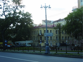
The first thing that strikes a visitor of Vasilievsky Island is the huge size of its half-kilometre long quarters – a characteristic that mirrors the building of Sankt Petersburg (the city's original German-language name) as ‘the city of façades’. More directly to the point, the island features a range of extraordinarily numbered streets (and thus not canals) that intersect three non-numerically christened arteries.Footnote 21 In fact, four Lines were dug through as canals in the first half of the eighteenth century, but as these silted up the whole projected ‘water checkerboard’ was built as a grid of streets instead. A further peculiarity is that the majority of Lines are doubly numbered (Figure 2): for the 15 Lines on the island, there exist 29 numbered streets altogether. Again, the explanation dates back to the time when the ‘drama of St Petersburg's rise from swamp’Footnote 22 was at its beginning: the sequential numbering of Lines originally referred to embankments on each side of a canal, and this feature in Trezzini's plans has never been revised.
The intersection of 4-ya–5-ya Liniya (‘4th–5th Lines’) and Sredniy Prospekt (‘Medium Artery’) on Vasilievsky Island. Photograph by author, 2008.

In the case of Vasilievsky Island's Lines, the literature on the early history of St Petersburg enables some speculation on how the idea of numerically baptizing its Lines was originally born. Whether the idea was the tsar's, Trezzini's or proposed by someone else seems to be unknown.Footnote 23 In any case, if its cue was taken from existing settlements, Mannheim could well have acted as a model. Given that the tsar had spent much of his youth and early adulthood in the cosmopolitan German Village of Moscow (a privileged neighbourhood where mainly Catholics and Protestants from different European countries were settled),Footnote 24 his fondness for mathematics and engineering, multi-purpose journeys and stays around Europe, and his incessant propensity to borrow and apply new ideas, this hypothesis sounds by no means unlikely.Footnote 25 One possible route of travel for the idea also goes through the learned and much-travelled circle of European professionals (architects, master builders, engineers, military persons, etc.) with whom Peter the Great collaborated in realizing his urban utopia.Footnote 26 Neither is it unreasonable to speculate that Philadelphia, the forerunner of street numbering in North America, was among the sources of inspiration (there were actually only 15 intertwining years between the implementation the first numbered streets in Philadelphia and the christening of Vasilievsky Island's Lines).Footnote 27 In the end, however, the adoption of the numerical system on the island was hardly a straightforward borrowing from any single geographical location, but more likely a choice influenced by several rationalist discourses of the time.Footnote 28
An important commonality among New Winchelsea, Mannheim and Vasilievsky Island is that they were all deliberately planned as the centres of political, military or economic power of varying importance, which were quickly planned and built according to a grid layout on previously non-urbanized land. In this respect, they share much in common with the grid-plan cities and towns of North America. Yet, regardless of the rationale that led to the adoption of street numbering in these three European cities, these numerical systems provided a method for adding a further representational layer of rationality on to the geometrically projected checkerboard landscape.
Pockets of numbered streetscapes in modern Europe
As noted above, street numbering has remained a marginal practice in Europe throughout the modern period. In the 10 national contexts mapped for this study, almost all of nineteenth- and twentieth-century numbered streetscapes are inconspicuous and peripherally located anomalies in the urban fabric. This observation is intriguing given that modern urbanization has seen a tremendous range of newly built landscapes across the continentFootnote 29 – among them countless logically ‘numerable’ parallel streets and grid layouts à la New Winchelsea, Mannheim and Vasilievsky Island. At least in principle, the ‘American system’ of street numbering could have become a ‘European system’, too. Why did Europe not follow this trajectory in the rationalization of its urban spaces?
As already evinced by Mannheim and Vasilievsky Island, there have been several endeavours to introduce large-scale, number-based street nomenclature systems in Europe, even in the oldest of its capital cities.Footnote 30 Farvacque-Vitkovic et al. mention one such early proposal as regards the alphanumerical rationalization of urban space in Paris. The utopian-rationalist proposal was devised by the French army general Pierre Choderlos de Laclos in 1787, who
envisioned a system ‘whose apparent logic is a poor disguise for its extreme complexity’. His system divide[d] the city on each side of the Seine into twenty sections or neighborhoods (400 × 1000 toises), assign[ed] them a letter and then number[ed] the streets by assigning ‘uneven numbers to streets running more or less parallel to the river and even numbers to streets that are substantially perpendicular’. Houses [were] then numbered ‘following the flow of the river for streets parallel to it’ and starting from the river on perpendicular streets. Addresses [were] given as a combination of numbers and letters, for example, District D, Street 8, house 25.Footnote 31
The fanciful theoretical plans of this type – in Choderlos de Laclos’ case reminiscent of the systematicity of Mannheim's addressing system, but on a much grander scale and as imposed on the necessarily irregular complex of quarters and streets – carried the day neither in Paris, ‘the capital of nineteenth century’,Footnote 32 nor elsewhere in Europe. In fact, a much more consequential contribution to the European trajectory of street naming was presented only a few years later.
In the tumult of the French Revolution, the Catholic priest and renewer Henri Grégoire (otherwise known for his input to the standardization of the French language) was consulted by the Comité de l'Instruction Publique to consider the problem of street naming. In place of both ‘the royal concern for creating a city in the image of the monarchy’, and piecemeal alterations of nomenclature driven by the ‘enthusiasms of the moment’ (à la earlier re-namings brought along by the Revolution), Grégoire:
insisted that ‘calm reason’ establish not a name here and a name there but a ‘combined system of republican nomenclature’. First, Grégoire emphasized, names should be short, comprehensible, euphonic, and appropriate; and second, they should be morally correct: ‘Each name ought to be the vehicle of a thought, or, rather, of a sentiment that reminds citizens of their virtues and their duties.’ System got citizens to the proper place and got them there properly, that is, with a lesson in mind. ‘Is it not natural to go from the Place de la Révolution to the rue de la Constitution and on to the rue du Bonheur?’Footnote 33
Already in the early modern era, the ruling dynasties had become objects of exaltation in the nomenclatures of European cities.Footnote 34 However, as Priscilla Parkhurst Ferguson notes, streetscapes were projected as landscapes of power more deliberately during the French Revolution than by any previous regime: ‘If the layout of the streets could not be rationalized . . . then rationalization would be partial – nomenclature might yet proclaim the revolution’.Footnote 35 The aim was not only to ‘facilitate business and travel, postal service, police surveillance, and tax collection’ through systematization of urban nomenclature and addressing systems, but also to politicize street names as the tools of republican-nationalist pedagogy. If anything, Grégoire's above-quoted recommendations represent an example par excellence of what Hugo Steger has termed the ‘ideological-rationalizing’ approach to urban naming, so characteristic to the nation-states of Europe since the nineteenth century. Unavoidably, this turn towards street naming as national pedagogy (a predilection for ‘street names with a lesson’) and the understanding of urban names as the vehicles of nation-building has had its effects on the ill fate of street numbering in Europe.
In Paris itself, the ceaseless renamings that occurred during the Revolution, the reign of Napoleon I and the ensuing nineteenth-century regimes made the city's nomenclature an unstable battlefield, an ideological stage to elevate selected aspects of the nation and its history in people's consciousness. Even so, Paris became the principal centre where the novel nineteenth-century models of street naming radiated to the rest of France and Europe.Footnote 36 On the one hand, the city was in the lead of a process where ‘commemorative street naming became a common feature of modern political culture’ in Europe.Footnote 37 On the other hand, it led the way as regards the symbolic clustering of urban nomenclature based upon the compartmentalization of urban space through miscellaneous name-motifs, from national provinces to rustic villages, folk traditions, sailing boat types, star constellations and (as will be seen) occasionally even numbers.Footnote 38
Apparently, the subsequent institutionalization of historically evocative and ideologically laden naming practices has effectively hindered politicians and authorities in European cities and towns to regard street numbering a viable choice. In France, for instance, numerical names for streets are very rare.Footnote 39 Whilst claiming to the contrary, a comment on the issue of ‘numerical landmarks’ by the semiotician Georges Mounin is symptomatic: ‘the designating of the streets themselves by numbers . . . is spreading in France, where I have seen it in the industrial area of Vitrolles-le-Roucas’.Footnote 40 Let me underscore the irony of this observation made in 1980: only one development in the whole of France that the author seems to have come across! While the example that Mounin mentions appears to have disappeared from more recent maps, rare clusters of numerical street names mainly from the post-war period do exist in certain French cities and towns, such as in the port and a separately located industrial area of Lille and the La Plane neighbourhood of luxury villas and winding roads in Cavaillon with two numerically named Avenues, three Rues and five Impasses.
Nonetheless, there are European cases where numbered streets are more abundant (see Figure 1). Obviously in part due to its strong historical, linguistic and economic ties with North America, the United Kingdom is a case in point. Again, it is beyond dispute that British street naming (even if perhaps looking more ‘prosaic’ and ‘unimaginative’ than French street nomenclature) is overwhelmingly dominated by non-numerical names.Footnote 41 However, the numbered streetscapes of relatively limited size in specific suburbs, industrial estates and former mining villages can be found around many cities and towns. In particular, sequentially numbered bunches of Avenues, mainly built and named in the nineteenth or early twentieth centuries, are clearly more common than in the rest of Europe.Footnote 42
At this point, selected glimpses at the British types of street numbering are pertinent. Representing the Regency style of the early nineteenth century, the posh First to Fourth Avenues in the historical seaside resort of Hove, two kilometres west from central Brighton, are located right in the middle of miscellaneously christened streets (among them St Johns Road, Waterloo Street, Holland Road and Grand Avenue) that all run parallel towards the Channel. A sense of arbitrariness of street numbering also applies to the suburbs of the poorer tiers of society, such as with First to Fourth Avenues in Keighley, 10 kilometres north-west from Bradford, originally built by a local textile-industry company for its workers in the 1870s. A uniform cluster of terraced houses and 10 numbered Avenues in Heaton, two kilometres east from Newcastle-upon-Tyne, stands as a late nineteenth-century example of such a residential pocket; next to it, in an identically planned neighbourhood, toponymic references to medieval King John dominate the namescape. By contrast, sequential street numbering has played a wider role in the rational ordering of local space in some mining towns and villages. At one extreme, the only streets within isolated Linton Colliery in Northumberland are still its First to Fifth Rows.Footnote 43 In Newtongrange, south of Edinburgh, the neighbourhood's First to Tenth Streets have been partly encircled by newer suburbanization and name-motifs brought along by it (Figure 3).Footnote 44
A street sign of one of the First Streets in the United Kingdom, located in Newtongrange, Scotland. The neatly lined brick-built cottages of the now partially gentrified neighbourhood were built by the Lothian Coal Company for its miners in the 1890s. Photograph: Maimu Berezkina, 2010.

Speaking of later British developments, the core of Milton Keynes from the late 1960s sticks out as a unique anomaly in the history of street naming in Europe. In fact, the modernist grid layout of the American-inspired new town boasts a fourfold series of numbered streets, including 40 street names such as North Fourteenth Street, Upper Fourth Street, Lower Ninth Street and South Thirteenth Street.Footnote 45 Otherwise, however, novelties figure in suburbs or out-of-town locations. Since the establishment of Trafford Park Village in Greater Manchester (currently embracing a layout of 5 numbered avenues and 11 streets) at the turn of the twentieth century, other estates dedicated to industries, out of which the South Hook LNG Terminal (originally an Esso refinery opened in 1960) with its Streets 1st–13th and Avenues A–S in Pembrokeshire is one of the biggest, have also been bestowed with alphanumerical street names. In addition, in some twentieth-century residential suburbs, in particular, streetscapes have been numbered – as with the numerical Avenues of (the old) York's Heworth or Northumberland's Morpeth – in spite of the irregularity of their layout. As Adrian Room has suggested with regard to England, ‘ordinal numbers’ have seemingly come to represent a particular thematic category of street naming in the British context.Footnote 46
Namescapes with street numbers, however, tend to be less common in continental Europe than in the UK. In some countries, they appear as practically non-existent. For instance, Eerste, Tweede and Derde Oosterparkstraat in Amsterdam and a street system from Gate 1 to Gate 8b in the maritime town of Måløy, Norway, seemingly belong to absolute oddities of namescape in their respective national contexts. The same also rings true for a humble cluster of First to Fifth Lines (apparently named after the model of Vasilievsky Island in the early twentieth century) in Tallinn's industrial area of Kopli; this is especially so since Estonia's Place Names Act of 2004 no longer allows numerical street naming.Footnote 47 In some other national settings, the cases of street numbering seem somewhat more numerous. In Sweden, instances vary between the four parallel ‘Long Streets’ of Gothenburg (in a traditional working-class area that has mutated into a hip concentration of nightlife and creative industries) to the recently built suburban idyll of Första, Andra and Tredje Gatan in the small town of Flen, near Eskilstuna. For their part, the Italian cases of numbered streets are relatively numerous by European standards. The occurrences are concentrated in post-war industrial estates (in Padua, for instance) and more or less upper-scale neighbourhoods in suburbs (San Felice in Milan) or out-of-town locations (Colle Spina in Labico, 40 kilometres south-east of Rome). With its quasi-sequential street-numbering system that runs by jumps from Strada 1 up to Strada 74, a hilly suburb of posh houses, swimming pools and winding alleys in Poggio dei Pini, near Cagliari in Sardinia, is obviously among the biggest concentrations of numbered streets in the whole of Europe.Footnote 48
Initially, an examination of urban toponymy in Germany seemed to suggest that the country is almost empty of numbered streets. Apart from Mannheim's eccentric quarter-based naming system, cases such as Erste – Dritte Strasse (First – Third Street) in Neuenrade and Erste and Zweite Fährgasse (First and Second Ferry Alley) in Bonn, both in North Rhine-Westphalia, are marginal at best. However, the capital city of Berlin itself proves a striking exception. In it, as many as 316 numbered (erratically running from three streets christened as Strasse 1 up to Strasse 994) and 38 lettered street names (from two Strasse As to Strasse Z) were in official use in 2008. Idiosyncratically, the names in question are dispersed throughout metropolitan Berlin – except its most central areas – without any apparent spatial-sequential systematicity.
A couple of examples help to clarify the extraordinary logic and history of this street-numbering (sub)system of the German capital, applied equally in other former Prussian cities and towns.Footnote 49 A very narrow and short Strasse 89, for instance, is currently located in the middle of Strasse 76, Strasse 77 and Strasse 175 in suburban Buchholz, 10 kilometres north of central Berlin. Notably, another Strasse 89 was located in Lichtenberg (five kilometres east from the centre) a century ago, until it was renamed as Schottstrasse after a local politician-industrialist in 1913. In contrast, the name Strasse 15 from 1921 is still used for a dishevelled street in an industrial estate near Schottstrasse.Footnote 50 As a still different type of instance, in Heiligensee on the north-western edge of city, in former West Berlin, Strassen 366, 367 and 368 are located within an area of detached houses from the last few decades. These examples imply that while Berlin's numbered streets have been viewed as a temporary expedient since the outset of their authoritative issuing in the second half of the nineteenth century,Footnote 51 in many cases, they have never been supplanted by non-numerical names. Further, whilst the bulk of today's numerical street names figure in small clusters in the suburbs of former East Berlin,Footnote 52 this is not always the case. Despite the Greater Berlin Act of 1920, many jurisdictions around the metropolis have resorted to numerical street naming in different decades (this is why the city still embraces duplicate, triplicate, quadruple and even fivefold numerical street names), and the practice has occasionally continued even after German unification. Although the quasi-rationally numbered Strassen only amount to 1.5 per cent of Berlin's street names and different types of honorific designations dwarf them in more prestigious locations, they no doubt represent a major anomaly in the modern history of European street naming.Footnote 53
Finally, what about the ‘heirs’ of Vasilievsky Island's Lines? In fact, the practice of christening streets numerically did not remain marooned on the island, but has been occasionally applied elsewhere in St Petersburg, in Russia and in north-eastern Europe. On the opposite side of the Neva River, where the centre of St Petersburg actually rose, the ordinal logic of street numbering was combined with religious and military name-motifs in two grid-patterned areas around the turn of the nineteenth century. In Peski district, north of the principal avenue of Nevski Prospect, 10 parallel streets were christened as First to Tenth Rozhdestvenskaya Streets after the Nativity of Our Lord Church.Footnote 54 More to the south in the current Admiralteisky district, streets that cut across the Izmailovsky Regiment were bestowed with terse names from First to Twelfth Roty in reference to surrounding military barracks.Footnote 55
Given that ideological transformations have forcefully remoulded the namescape of St Petersburg in the course of modernization,Footnote 56 the fate of its numbered streets is of interest from the vantage point of their potential resilience to re-namings. Speaking of the city's street-naming system as a whole, the ideals of modernizing Russian nationalism (with its multiple imperial, socialist and post-socialist variants) have largely dominated its development since the mid-nineteenth century.Footnote 57 Much like the rest of Europe, in some neighbourhoods streets have been named after other cities, provinces and rivers, in others after cultural figures, rulers and political emblems. Predictably, political and historical commemorations, in particular, have been the recurrent objects of toponymic erasures after regime changes. Most dramatically, the first six years after the Bolshevik Revolution saw the re-naming of at least a third of the city's street names.Footnote 58 In 1923, the aforementioned clusters of numbered streets in Peski and Admiralteisky districts were also renamed as 1st – 10th Sovetskie (‘Soviet’) Streets and 1st – 13th Krasnoarmeiskaya (‘Red Army’) Streets, respectively (names by which they are known even 20 years after the dawn of post-socialist rule).Footnote 59 Notably, the numerical elements in these names have thus been preserved, as has been the case with Vasilievsky Island's Lines throughout symbolic cleansings of urban space otherwise experienced in St Petersburg.
In a similar vein, isolated occurrences of variably aged numerical street names have stood the test of time in the outskirts of St Petersburg itself (to mention only an industrial estate in Smolnaya with its First to Fifth Lines and First to Eight Poperechnaya Streets), elsewhere in Russia (several cases in metropolitan Moscow, for instance) as well as in neighbouring countries like Estonia (see above on Lines in Kopli, Tallinn) and Finland. In the latter context, the most prominent cases of numerical street naming date back to the time when Finland was a Grand Duchy of Russia (1809–1917).Footnote 60 In the industrial town of Forssa, for instance, a local textile company zoned a densely built grid-patterned neighbourhood with 10 sequentially numbered Lines for its workers in the 1870s.Footnote 61 Another, better-documented case from the time of early industrial urbanization is found in Helsinki's Kallio, a neighbourhood built quickly to ease a pressing housing shortage in the city.Footnote 62À la Vasilievsky Island, various parallel streets that ran through its working-class quarters were christened as First to Fifth Lines in the late 1880s. Notably, however, once Finland had become an independent nation-state in 1917, the legitimacy of these names was brought into question by patriotic Helsinkians and authoritative committees on several occasions between the 1920s and 1960s. In the petitions, Kallio's Lines were disparaged as ‘mechanistic’ and ‘non-poetic’ in comparison with ‘real street names’, but the efforts to rename them were never sanctioned by the city council. In 1928, for instance, the council voted to preserve the existing names. In the light of this article's investigations, however, there was considerable historical irony in the rationale for this decision, as the Lines were (mis)judged as representing former (and thus historically noteworthy) ‘American’ influence in local street nomenclature.Footnote 63 Be that as it may, the five Lines of Kallio still stick out – as do some other numbered Lines and a couple of newer suburban streets around the country – as anomalous pockets in the otherwise European-style symbolic landscapes of Finnish cities.
Conclusion
Number-based street-naming systems have remained curiosities throughout the urban history of Europe. Aside from a few relatively prominent occurrences, originating in the early modern (Mannheim, Vasilievsky Island) and modern (Milton Keynes, Berlin's oddly disjointed suburban names) periods, the bulk of existing numbered streets in the 10 countries considered here fall into three categories: (1) clusters of parallel streets within suburbs or industry-related settlements built in the nineteenth or early twentieth centuries, (2) industrial estates of relatively recent origin and (3) newer suburban and out-of-town residential and recreational developments with either regular or irregular street layouts. In a number of the national contexts, all of these street-name categories are practically non-existent, while in the United Kingdom, in particular, all categories sporadically dot cities and their outskirts. Even in the British context, however, the significance of the sequential numbering of streets for the rational ordering of local urban space is typically very limited. Instead, a common European feature is that alphanumerical street names are arbitrarily given a role – among a multitude of other name-motifs – in the thematic clustering of more or less minor pockets of the urban fabric. Indeed, the seeming proliferation of street numbering across Europe in the industrial and post-industrial eras has most likely occurred due to the more general need to invent ever more themes of street naming in the face of urban growth.Footnote 64
Given that this article has also evinced instances of the resilience of numerical street names (in St Petersburg and Helsinki, in particular) in the face of ideologically motivated renaming campaigns and proposals, their persistent marginality in Europe is an all the more intriguing enigma. What factors explain the peripheral status of street numbering in the European context? One obvious cause is related to the long history of urbanism and the built environment on the continent. To paraphrase Mounin's somewhat blunt transatlantic comparison, ‘the American conditions of generally starting from scratch, with freedom of space and land configuration’ did not apply when modern gridiron plans and street-naming reforms began to spread across Europe, which in turn hindered the mushrooming of ‘numerical landmarks’ insofar as street names are concerned.Footnote 65
In light of this article's examples from the modern period, an even more crucial explanation lies in the institutionalized favouring of pedagogic rather than straightforwardly ‘rational’ street names. The outset of nomenclature modernization in the tumultuous context of national stirrings, regime changes, geo-political conflicts and border shifts cannot be overlooked. In particular, the mushrooming of mutually competing European nationalisms in the nineteenth century paved the way for the exploitation of street naming as a pragmatic urban application of nationalist history-writing. In contrast to the simultaneous spread of house-numbering as a strictly rational spatio-demographic technique, it was the constitution of the continent's nation-states as historically rooted ‘imagined communities’ that determined the trajectory of its newly institutionalized street and place-naming practices.Footnote 66 As the theorists of nationalism from Benedict Anderson to Pierre Bourdieu have stressed, a boom in the search for ‘people-uniting’ authenticity from the past (a practice that was essentially supported by the exaltation of nation-specific ‘print-languages’ and modern methods of ‘language-engineering’) was a distinctive feature of the symbolic shaping of many if not all European nation-states in the nineteenth century.Footnote 67
As the same legacy of street naming has continued well beyond the nineteenth century, it is not accidental that official namescapes in European cities still very often serve as the linguistic equivalents of nationalistic ceremonies, monuments and museums – spaces in which the established traditions are exhibited and the dissonant ones excluded, among them numerical street names.Footnote 68 By the early twentieth century, the European nation-builders’ obsession with history had consolidated into a custom that stood, in the minds of most policy-makers, planners and street-naming committee members at least, as antipodal to the ‘non-poetic’ rationalism or ‘romanticism of numbers’ rife in North American street nomenclatures.Footnote 69
As my last vignette, an episode from Madrid in 1931 explicitly highlights this hegemonic European attitude frequently encountered in this article. In the midst of the reconfiguration of public spaces and nomenclatures by the newly elected progressivist leaders of the Second Republic (1931–36/39), a royalist councilman made a counter-proposal of adopting a system that in his view was ‘a norm in modern localities’ (evidently a hint at American urbanism), namely to overcome quarrelling over street naming by identifying the capital's new streets with politically neutral numbers.Footnote 70 Symptomatically, the bill was rejected by the city council on the basis of being ‘opposed to the traditional Spanish spirit . . . of honouring citizens by giving their names to cities and villages’.Footnote 71 In a similar vein, in today's European cities instructions regarding official street naming frequently include a de facto rule that ‘the use of numbers should be rejected’ – at one extreme, Estonian legislation even forbids numerical street naming nationwide.Footnote 72 As the above mappings have made clear, the institutionalized privileging of street names with historical lessons has left little room for the rationalization of space through the use of street numbering in Europe.
However, all this ought not to mislead us to conclude that the shunning of numerical street names has been antithetical to the overall rationalization of space in European cities. As said, all institutionalized street names contribute to the systematic identification of places and people, even if non-alphanumerical names do this job somewhat less efficiently than street-naming systems based on the ‘higher’ sequential logic. Moreover, the fate of street numbering in Europe has not only been conditioned by the popularity of honorific and thematic naming, but also by an array of newer technologies of spatially precise knowledge-production and governance, from house numbers to postal codes (an ‘inter-scalar’ system of addressing initiated in the Soviet Union in the 1930s) and the IP-addresses of the Internet age.Footnote 73 In fact, it is plausible that the introduction of overlapping systems of spatial addressing has made the stipulations of bestowing European streetscapes with number-based systematicity increasingly if not utterly obsolete. Despite the experiments and anomalies documented in this article, the ‘Old Continent’ largely missed the boat of street numbering due to the acuteness of nationalistic identity politics, yet this does not mean that its cities are today less rationally organized and governed than urban spaces in the rest of world.