The rise to prominence and subsequent collapse of Classic Maya civilization remain complicated and multivariate problems. As more local and regional historical sequences of change are detailed throughout the Maya lowlands, the complexity of and variation within these processes have become increasingly apparent (e.g., Aimers Reference Aimers2007; McAnany and Gallareta Negrón Reference McAnany, Negrón, McAnany and Yoffee2010; Webster Reference Webster2002; Yaeger and Hodell Reference Yaeger, Hodell, Sandweiss and Quilter2008). Scholars of the lowland Maya often use periods of growth and stasis in the built environment to interpret the dynamics of the ancient Maya political landscape. While perhaps not an ideal proxy, construction histories among ancient Maya centers do reflect labor appropriation and prosperity, and may serve indirectly as a measure of political clout, especially in the absence of carved monuments, murals, and other material classes that display hieroglyphic texts. Changes in the built environment over time can point to periods of rapid growth, relative stasis, decline, and abandonment. Consequently, the precision and accuracy with which scholars are able to measure the growth and decline of the ancient Maya built landscape becomes of paramount importance.
At the archaeological site of La Milpa, Belize, previous work in and around the monumental center pointed to: (1) a nucleated Late Preclassic monumental component largely restricted to the northern end of the site, with (2) modest prosperity during the Early Classic period, followed by (3) a massive Late-to-Terminal Classic expansion, before (4) rapid site abandonment in the early ninth century, apparently prior to the completion of numerous construction projects (Hammond and Tourtellot Reference Hammond, Tourtellot, Demarest, Rice and Rice2004; Hammond et al. Reference Hammond, Tourtellot, Donaghey and Clarke1998). New research calls for a reexamination of the historical trajectory originally proposed for this moderate-sized polity. In this paper, we present new data from the monumental core of La Milpa that point to a much more pronounced Late Preclassic (ca. 400 b.c.–a.d. 250) architectural foundation that extended into the southern plazas area. Our data also suggest that, while the site's greatest phase of construction and expansion did indeed occur during the late eighth to early ninth centuries a.d., there appears to have been a more gradual build-up of the monumental core prior to these large-scale Late Classic period (ca. a.d. 600–800/850) expansions than previously understood. Significantly, our data also push the decline and ultimate abandonment of La Milpa into the tenth century or later, rather than suddenly collapsing in the early ninth century as previously proposed. However, political authority at La Milpa appears to have been significantly reduced during its Terminal Classic period occupation. The historical trajectory of La Milpa's built environment and its persistence into the tenth century in the southern plazas area have significant implications for previous models of ancient Maya population growth and decline in the Three Rivers region, ancient Maya political history and abandonment surrounding La Milpa, and the ceramic chronologies upon which many of these models are based.
MEASURING CHANGE AT ANCIENT MAYA CENTERS
Scholars have traditionally relied upon both archaeological and epigraphic data sets to interpret the growth and decline of ancient Maya polities. In the southern Maya Lowlands, a focus on epigraphic research has been particularly important in deciphering the political actions of kings and historical trajectories of city-states throughout the Classic period (Chase and Chase Reference Chase, Chase, Brown and Stanton2003; Chase et al. Reference Chase, Chase and Smith2009; Grube Reference Grube2001; Houston Reference Houston2000; Martin and Grube Reference Martin and Grube1995). Hieroglyphic texts reveal unparalleled accounts of kingship, warfare, alliance, marriage, and both religious and political actions of ruling elites. Indeed, the Classic period across the Maya Lowlands is, in part, defined by the extensive use of hieroglyphic texts displayed on buildings, carved monuments, and other objects (Sharer and Traxler Reference Sharer and Traxler2006). However, given the comparatively restricted sample upon which archaeologists must rely, the deterioration of the archaeological record itself, and the limited contexts in which ancient Maya writing is found, hieroglyphic texts are often illegible, absent, or otherwise completely unavailable for reconstructing ancient Maya political growth and decline. For the periods preceding and following Classic Maya civilization the written record is scant. Ancient texts dating to the Late Preclassic period have been identified, but they have yet to be deciphered (Hansen Reference Hansen1991; Houston Reference Houston2006; Saturno et al. Reference Saturno, Stuart and Beltrán2006), while the Terminal Classic period is characterized by a decline in the institution of divine kingship and the accompanying display of hieroglyphic statements (Sharer and Traxler Reference Sharer and Traxler2006). In such cases, other material classes, like the built environment itself, take on greater importance to archaeologists in the analysis of political relationships between sites (de Montmollin Reference de Montmollin1988, Reference de Montmollin1995) and the political growth and decline of ancient Maya city-states.
The Built Environment as a Measure of Power
While the built environment encompasses many elements across the landscape, such as terraced-field systems, raised and ditched fields, patio groups, and other edifices, we are particularly concerned with monumental architecture, including prepared plazas, palaces, temples, and tombs. Such constructions require significant planning and engineering, but more importantly, they require appropriation and direction of both skilled and unskilled labor towards their completion. Trigger (Reference Trigger1990) makes a particularly salient argument that monumental architecture among early civilizations represents a form of conspicuous consumption, whereby the control of energy (i.e., labor) is recognized to reflect political power. Furthermore, the expression of that power is symbolically reinforced through monumental architecture, which remains on the landscape as a highly visible signature of authority to all socioeconomic classes of society (Trigger Reference Trigger1990:127). Archaeologists studying the ancient Maya have often interpreted the built environment in a similar fashion, pointing to monumental architecture as a reflection of the political clout of Maya rulers. In the Middle and Late Preclassic periods, for instance, Nakbe and El Mirador are argued to have been the emerging centers of powerful authorities, interpreted in part from their ambitious displays of monumental architecture, early use of cut-stone masonry, spatial extent of their central precincts, and systems of interconnected causeways (Hansen Reference Hansen and Houston1998, Reference Hansen and Grube2001). Elsewhere, Cheek (Reference Cheek, Urban and Schortman1986) utilizes construction data from the Main Group at Copan to measure change throughout the Classic period. He suggests that the scale of work and its periodicity reflect larger social processes related to the appropriation and distribution of resources at a site. While quantitative studies have suggested that some aspects of the ancient Maya built environment may not have been as laborious as they appear (Abrams Reference Abrams1994, Reference Abrams and Houston1998), the ultimate message of power and authority may still be embedded in the monumentality of the final product. Hence, although public architecture among the ancient Maya often accrued incrementally—utilizing earlier buildings as foundations for later constructions—the ultimate scale of construction still reflected communication about power: the larger the construction, the more powerful the message (Trigger Reference Trigger1990; Webster Reference Webster and Houston1998).
Abandoned construction projects constitute a particularly important subcategory of the built environment and can play a central role in understanding loss of power, societal disintegration, and the abandonment process surrounding individual buildings, entire centers, or regions (Inomata and Webb Reference Inomata, Webb, Inomata and Webb2003). This becomes particularly important when contextual consideration is also given to artifact assemblages associated with abandonment. In the Maya region, architectural and artifactual data are often combined to offer insight into the variable speed and nature of abandonment, be it relatively sudden or prolonged (Aimers Reference Aimers, Inomata and Webb2003; Iannone Reference Iannone2005; Inomata Reference Inomata, Inomata and Webb2003; Inomata et al. Reference Inomata, Ponciano, Chinchilla, Román, Breuil-Martínez and Santos2004; McKee and Sheets Reference McKee, Sheets, Inomata and Webb2003; Palka Reference Palka, Inomata and Webb2003; Suhler and Freidel Reference Suhler, Freidel, Inomata and Webb2003). For example, at Aguateca, Inomata and colleagues (2004) identified an unfinished temple based on the remains of a construction ramp, unfaced terraces with exposed rubble core, and other features. Combined with the presence of defensive walls, they interpret this incomplete construction to have been the result of rapid abandonment largely due to military attack. Artifact assemblages elsewhere at the site provide additional support for this scenario, where excavations found burned elite residences along a causeway with large numbers of artifacts remaining in situ (Inomata Reference Inomata, Inomata and Webb2003:46–51). Excavations just outside the city, however, found most spaces in a clean state, suggesting more gradual abandonment as residents took time to collect their belongings, perhaps even returning on multiple occasions (Inomata Reference Inomata, Inomata and Webb2003:57–58). In this case, evidence at Aguateca points to rapid decline in political authority accompanied by sudden abandonment of some elite sectors, while outlying residential areas were abandoned more gradually.
A theoretical framework centered on the built environment can be a useful tool in the evaluation of ancient Maya political history, particularly when hieroglyphic statements are absent. Furthermore, as demonstrated above, the built environment can point to differential patterns of growth and decline within a single center when coupled with analysis of artifact assemblages. However, the veracity of these explanatory models will continue to rest on the precision and accuracy with which the archaeologist is able to measure change over time.
Ceramics and the Measurement of Time
Ceramics have long been the instrument by which archaeologists in the Maya lowlands assess the age of excavated deposits. In some cases, where assemblage characteristics combine favorably with recovery techniques and preservation conditions, radiometric dates in sufficient quantities and from sufficient contexts allow researchers to anchor the ceramic chronology for a particular site or region more precisely in time. They may also permit archaeologists to subdivide otherwise long-lasting complexes into more manageable and meaningful units of time. For example, at Xunantunich, LeCount and colleagues (2002:54) used 22 radiocarbon dates to correlate their ceramic chronology for the Late and Terminal Classic periods. They were also able to separate the Terminal Classic complex from the earlier Late Classic complexes because their assemblages included highly specific Terminal Classic diagnostics (LeCount et al. Reference LeCount, Yaeger, Leventhal and Ashmore2002:45–46).
While the ceramic chronologies proposed for sites in northwestern Belize typically show a Terminal Classic period Tepeu-3-equivalent complex (Sagebiel Reference Sagebiel2005:Figure 4.1; Sullivan and Sagebiel Reference Sullivan, Sagebiel, Scarborough, Valdez and Dunning2003:Figure 3.1; Valdez and Houk Reference Valdez, Houk and Houk2000:Figure 11.2), researchers are usually unable to assign a Terminal Classic affiliation to specific excavation contexts. Sullivan et al. (Reference Sullivan, Houk and Valdez2007:138) have expressed the difficulty of trying to define a clear chronological ‘break’ between the Late Classic (Tepeu 2) and the Terminal Classic (Tepeu 3) periods, specifically noting the absence of Terminal Classic ceramic markers such as Daylight Orange: Darknight Variety, Fine Orange, Plumbate, and other Terminal Classic ‘finewares’ at most upland sites in the area. The problem with identifying the Terminal Classic period from ceramics is not, of course, restricted to northwestern Belize. Chase and Chase (Reference Chase and Chase2007:17–18) describe the process of identifying Caracol's Terminal Classic period material as “a long-term negotiation with the archaeological record,” noting that only rarely could Terminal Classic contexts be easily identified. Even Smith (Reference Smith1955) had problems subdividing Tepeu into subphases at Uaxactun, except when armed with well-preserved mortuary vessels.
The issue, as it relates to this paper, lies in how ceramic chronology affects models of political history surrounding ancient Maya centers. Because, in most excavation contexts, Tepeu 2 and 3 cannot (currently) be reliably separated into discrete chronological units in northwestern Belize, the resulting conversations about features, construction episodes, etc., become muddled and often burdened with labels such as “Late/Terminal Classic” or “Late-to-Terminal Classic,” as imprecise as those descriptors may be. Sagebiel (Reference Sagebiel2005:760–763) provides an excellent discussion of some of the issues with separating the two subphases at La Milpa, and reports some success in identifying Late Classic 3 Coffin Gate complex contexts based on changes in slip, vessel size, and vessel form. However, the general nature of the La Milpa Core Project (LMCP) excavations (non-penetrating and overwhelmingly of collapse debris) limits the recovery of sufficient ceramics from individual contexts to see these differences. Consequently, much of our following discussion uses the “Late-to-Terminal Classic” terminology to describe architectural contexts at La Milpa. However, as presented in this paper, chronometric dates produced from our work open the door to a discussion of a distinctively Terminal Classic period occupation at the site. When placed in the context of the built environment, our data point to a significantly different overall growth curve for La Milpa's political history than previously understood, but importantly, they also suggest a more prolonged and complex process of abandonment associated with the city's final occupation phase.
LA MILPA AND THE THREE RIVERS REGION
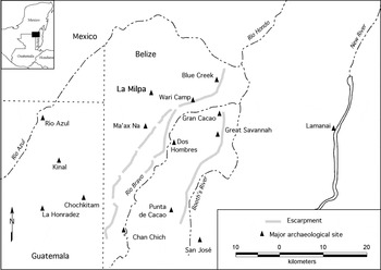
La Milpa is in a geographically defined study area known as the Three Rivers region, which encompasses northwestern Belize, adjacent territory in northeastern Peten, Guatemala, and a small portion of Quintana Roo, Mexico (Figure 1). In addition to La Milpa, the Three Rivers region contains several large ancient Maya cities, including Rio Azul and La Honradez, and a large number of medium-to-large secondary centers with abundant outlying settlements and landscape features. Geographically the region straddles the eastern edge of the Peten Karst Plateau (Dunning et al. Reference Dunning, Jones, Beach, Luzzadder-Beach, Scarborough, Valdez and Dunning2003). Culturally, the plateau loosely defined the Central Lowlands, which was home to some of the largest Maya sites such as El Mirador, Tikal, and Calakmul. The large site of Lamanai lies east of the region in the Belize Coastal Plain, a contrasting physiographic province marked by its low elevations and slow moving rivers.
Geographic location of La Milpa and the Three Rivers region in northwestern Belize.

The Central Lowlands region was home to some of the earliest Maya settlements in the Middle Preclassic and witnessed the development of the first dynasties of divine kings (Sharer and Traxler Reference Sharer and Traxler2006). Thanks to the widespread use of hieroglyphic writing during the Classic period, the political histories of many Central Lowland cities and dynasties are well documented. Unfortunately, much of the Three Rivers region is characterized by a dearth of hieroglyphic texts, and archaeologists working in the region are forced to rely on other lines of evidence to reconstruct the region's history and assess its place in the wider Central Lowlands' political arena. What little is known about individual rulers and historical events in the region comes from just a handful of monuments; only Rio Azul, La Honradez, and La Milpa have carved stelae with legible or partially legible texts. At La Milpa, this is restricted primarily to Stela 7, dedicated in a.d. 780, and the identification of a certain Late Classic ruler named Ukay (Grube Reference Grube1994; Hammond and Tourtellot Reference Hammond, Tourtellot, Demarest, Rice and Rice2004).
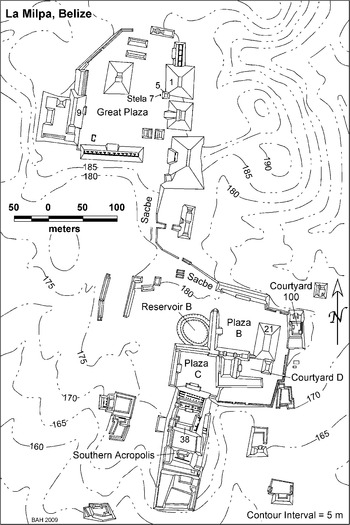
Located in the Programme for Belize ecological preserve, La Milpa sits on a limestone ridge in the uplands of the eastern Peten Karst Plateau in northwestern Belize (Dunning et al. Reference Dunning, Jones, Beach, Luzzadder-Beach, Scarborough, Valdez and Dunning2003). The northern portion of the site is dominated by the Great Plaza (Plaza A) and associated buildings and monuments which include the four largest pyramids at the site, the tallest measuring 24 m in height (Figure 2). The Great Plaza also includes several range structures, two ball courts, and 17 stelae. The southern part of the site is characterized by the smaller Plazas B and C, several courtyards, and the Southern Acropolis. This southern architectural group appears to have been linked to the Great Plaza via a causeway or sacbe, though it is uncertain if the sacbe was ever fully completed (Hammond and Tourtellot Reference Hammond, Tourtellot, Demarest, Rice and Rice2004:292). Reservoir B, one of several associated with the monumental center lies just west of Plaza B (Scarborough et al. Reference Scarborough, Becher, Baker, Harris and Valdez1995). Combined, La Milpa's northern and southern cores of monumental architecture span about 26 ha.
Simplified map of La Milpa's monumental core and principal structures mentioned in the text (adapted from Hammond and Tourtellot [2004:Figure 13.1] and from Tourtellot [Reference Tourtellot1993:Figure 1]).

By its Late Classic apogee, La Milpa may have administered a residential population stretching about five radial kilometers from the monumental core, the distance at which density of residential and land management features (e.g., low terraces, berms) begins to significantly decline (Hammond et al. Reference Hammond, Tourtellot, Everson, Sagebiel, Thomas and Wolf2000; Tourtellot et al. Reference Tourtellot, Everson, Hammond, Iannone and Connell2003). Several moderate-sized centers have also been located within the extent of residential settlement surrounding La Milpa, possibly serving in some administrative capacity for the larger polity (Hammond et al. Reference Hammond, Tourtellot, Everson, Sagebiel, Thomas and Wolf2000; Tourtellot et al. Reference Tourtellot, Wolf, Belli and Hammond2000). Closer to the monumental core, there appears to have been substantial efforts to manipulate drainages and direct runoff to more effectively manage seasonally restricted rainfall, an engineering practice consistent with other centers in the Maya Lowlands (Scarborough et al. Reference Scarborough, Becher, Baker, Harris and Valdez1995; Scarborough and Gallopin Reference Scarborough and Gallopin1991).
La Milpa was initially brought to archaeological attention by Sir J. Eric Thompson in 1938, but it did not undergo focused investigation until the 1990s (Hammond and Tourtellot Reference Hammond, Tourtellot, Demarest, Rice and Rice2004). Preliminary research began with the Rio Bravo Archaeological Project (Guderjan Reference Guderjan and Guderjan1991), but continued most intensively between 1992 and 2002 under Boston University's La Milpa Archaeological Project (LaMAP), which generated the basic framework for La Milpa's political history (Hammond and Tourtellot Reference Hammond and Tourtellot2003, Reference Hammond, Tourtellot, Demarest, Rice and Rice2004; Hammond et al. Reference Hammond, Tourtellot, Donaghey and Clarke1998). In the monumental core, archaeological research was designed to define an architectural history for the site, with a primary focus on the Great Plaza and Southern Acropolis.
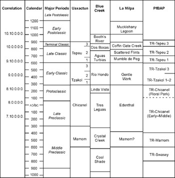
LaMAP's excavations among the western and southern buildings of the Great Plaza identified Late Preclassic beginnings of La Milpa (Hammond et al. Reference Hammond, Tourtellot, Donaghey and Clarke1998), while nearby looter's trenches demonstrate complex construction histories in most areas around the Great Plaza, including a modest Early Classic (ca. a.d. 250–600) development (Hammond et al. Reference Hammond, Tourtellot, Donaghey and Clarke1998). However, the visible phase of La Milpa's Great Plaza dates almost exclusively to the Late-to-Terminal Classic period, evidenced by the predominance of Three Rivers (TR)-Tepeu 2–3 ceramic types associated with the latest phase of construction (Hammond and Tourtellot Reference Hammond, Tourtellot, Demarest, Rice and Rice2004; Schultz et al. Reference Schultz, Gonzalez and Hammond1994) (Figure 3). Hammond and Tourtellot (Reference Hammond, Tourtellot, Demarest, Rice and Rice2004:293) attribute much of this rapid growth to the Late Classic ruler Ukay, who dedicated Stela 7 in a.d. 780. Based primarily on the lack of significant buildings along the Great Plaza's north and northwest sides and the apparently unfinished nature of other constructions—Structure 1, for instance, and possibly the north ball court (Norman Hammond, personal communication 2009)—the latest expansion of Plaza A is argued to have been incomplete at the proposed time of La Milpa's abandonment in the first half of the ninth century a.d. (Hammond and Tourtellot Reference Hammond, Tourtellot, Demarest, Rice and Rice2004; Hammond et al. Reference Hammond, Tourtellot, Donaghey and Clarke1998).
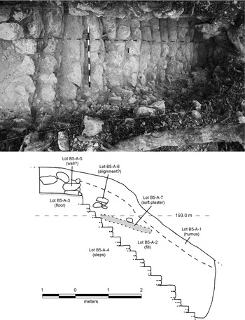
Ceramic chronologies for the Three Rivers region. Uaxactun chronology from Smith (Reference Smith1955); La Milpa chronology from Sagebiel (Reference Sagebiel2005); Blue Creek chronology from Kosakowsky and Lohse (Reference Kosakowsky and Lohse2003); Programme for Belize Archaeological Project chronology, which applies to the general region south and east of La Milpa, from Sullivan and Valdez (Reference Sullivan and Valdez2004).

Contrary to the deep construction history of the Great Plaza area, much of the southern architectural group was thought to have been established late in La Milpa's history. In the Southern Acropolis, excavations revealed multiple renovations, painted benches or thrones, reorientation of access ways, and unfinished expansion projects. At least some of these activities can likely be placed in the early ninth century, evidenced by a calibrated radiocarbon age (cal a.d. 770–880, 1σ) associated with the infilling of a room and the presence of TR-Tepeu 3 ceramics linked to unfinished constructions in the southernmost portion of the Southern Acropolis (Hammond and Tourtellot Reference Hammond, Tourtellot, Demarest, Rice and Rice2004:292–294). Nearby in the Plaza B area, Structure 21, La Milpa's fifth largest building, was also believed to have been an incomplete construction project at the time of abandonment, based in large part on its unusual, flat summit (indicating no superstructure), lack of frontal stairway, and absence of faced masonry (Hammond et al. Reference Hammond, Tourtellot, Donaghey and Clarke1998:833). Despite the recovery of modest amounts of Late Preclassic ceramics from fill contexts in the Reservoir B area (Sagebiel Reference Sagebiel2005:602, 607), monumental construction around La Milpa's southern plazas was not reported for periods prior to the Late-to-Terminal Classic, leading to the suggestion of a massive expansion late in the city's occupational history and with little to no antecedent construction (Hammond et al. Reference Hammond, Tourtellot, Donaghey and Clarke1998:833).
Excavation and ceramic data suggested an abrupt early ninth century abandonment of La Milpa with several major construction projects left unfinished, including Structure 21 in Plaza B and others in the Great Plaza, as well (Hammond and Tourtellot Reference Hammond, Tourtellot, Demarest, Rice and Rice2004; Sagebiel Reference Sagebiel2005). TR-Tepeu 2–3 ceramics account for the vast majority of those recovered by LaMAP within the monumental core, supporting the conclusion of significant Late-to-Terminal Classic occupation and continued construction at the site late in its history. As noted above, although most TR-Tepeu 2–3 sherds cannot be assigned more precisely to either the Late or Terminal Classic periods, Hammond and Tourtellot (Reference Hammond, Tourtellot, Demarest, Rice and Rice2004:297–299) speculated that the absence of clear Terminal Classic diagnostic ceramic types such as Plumbate and Fine Orange could be an indication that the site was abandoned around a.d. 830. With excavated palaces uniformly cleared of their contents and no evidence for violence or destruction, the occupation of La Milpa was suggested to have ended suddenly and unexpectedly, with significant and widely distributed construction projects still underway (Hammond and Tourtellot Reference Hammond, Tourtellot, Demarest, Rice and Rice2004:300). The only subsequent occupation or use of the site documented by LaMAP was a small-scale squatter presence in the Great Plaza during the Early Postclassic period and intermittent monument veneration thereafter (Hammond and Bobo Reference Hammond and Bobo1994).
NEW RESEARCH IN LA MILPA'S SOUTHERN PLAZAS
Since 2007, the LMCP has conducted research among the southern plazas, with particular emphasis on Plaza B and Courtyard D (Houk and Zaro Reference Houk and Zaro2010). Building on previous research outlined above, we present new data from the southern plazas, an area not intensively studied by LaMAP, that significantly alter current thinking about La Milpa's historical trajectory.
Plaza B is the second largest plaza at the site, measuring approximately 73 × 100 m. Its northern, western, and southern margins are defined by range buildings while the plaza's eastern side is dominated by Structure 21, an 18 m-high pyramid with a broad, flat summit. However, the eastern margin of Plaza B is more directly defined by the small Courtyard 100 and its associated mounds. Courtyard D sits adjacent to the southeastern margin of Plaza B, and it measures approximately 25 × 30 m. It is nearly enclosed on its north, west, and south sides by range buildings, while its eastern margin is characterized by the modest Structure 25 pyramid.
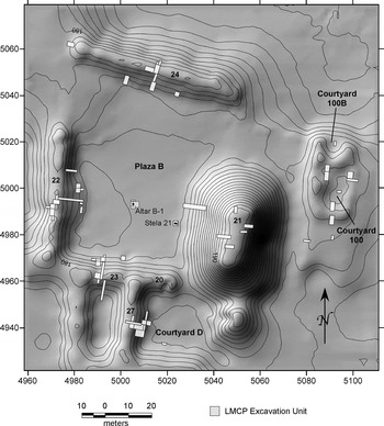
In addition to plaza and courtyard surfaces, our excavations targeted Structures 21–24 around Plaza B, several low mounds in Courtyard 100, and Structure 27 on the west side of Courtyard D (Figure 4). All ceramic analyses mentioned here were conducted by Lauren A. Sullivan at the Rio Bravo Research Station during the 2007–2010 field seasons. Our discussion below is organized around: (1) an expanded Late Preclassic foundation at La Milpa, (2) Classic period renovations around Plaza B, and (3) extended Terminal Classic component into the tenth century.
Shaded relief and contour map of Plaza B area with excavation units completed by the La Milpa Core Project, 2007–2010.

Late Preclassic Monumental Construction in the Southern Plazas
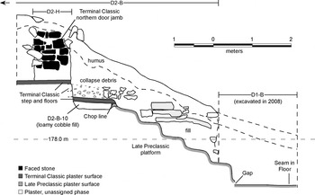
Excavation of Structure 27 in Courtyard D encountered a thick-plastered, multi-tiered platform beneath Late-to-Terminal Classic architecture. Ceramic fragments recovered from overburden, collapse, and construction fill contexts associated with the latest architectural phase of the building are predominantly TR-Tepeu 2–3 types, confirming that the latest construction activity largely occurred during the Late-to-Terminal Classic period. While our excavations did not penetrate the buried platform, its morphology along with the quality and thickness of plaster surfacing strongly suggests a Late Preclassic period of construction.
Horizontal and vertical exposures revealed at least five tiers associated with the platform, with a higher sixth tier truncated by the latest construction episode (Figure 5). The heights of the five preserved tiers range from 32 to 49 cm, with depths ranging from 57 to 65 cm. The preserved portion of the platform measures just over 2 m in height, though given the limited exposure provided by the excavation of Structure 27 (approximately 10 m2), additional dimensions remain unknown. The Late Preclassic platform was chopped by the final construction phase of Structure 27, revealing the platform to have a 20 cm-thick plaster surface, although this may have been composed of two separate layers of plaster (Houk and Smith Reference Houk, Smith and Houk2010:115–116). We suspect an inset stairway is also present on the structure, buried beneath later Classic period renovations discussed in greater detail below.
Cross section of Structure 27 showing buried Late Preclassic platform truncated by Terminal Classic construction. View to the north.

The discovery of the Late Preclassic platform beneath Structure 27 expands our understanding of the early settlement of La Milpa. The buried platform represents the only recorded Late Preclassic monumental construction at La Milpa beyond the Great Plaza, but it is not the only evidence for Late Preclassic settlement outside the northern part of the site. In her ceramic study at La Milpa, Sagebiel (Reference Sagebiel2005:602, 627) identified Late Preclassic ceramics from several test pits in and around Plaza B and suggested there may have been Late Preclassic occupation around Reservoir B. Sagebiel's (2005) ceramic data and the newly discovered platform beneath Structure 27 suggest to us that, indeed, the Late Preclassic settlement at La Milpa included some portion of the southern plazas area as well. If the construction sequence at Structure 27 is representative of other buildings in the southern portion of the site, where looting and penetrating excavations have not occurred to any large extent, then La Milpa's monumental core would have been significantly larger during the Late Preclassic period than previously suspected. Hence, initial growth around the site might have been even more pronounced than once thought.
Classic Period Renovations in the Southern Plazas
While previous work concluded that La Milpa expanded rapidly during the Late-to-Terminal Classic period, excavation of both Plaza B and Courtyard D structures reveal more gradual Classic period architectural growth. This includes incremental modifications of Structure 27 in Courtyard D, as well as both completed and incomplete renovation projects around Plaza B.
Courtyard D
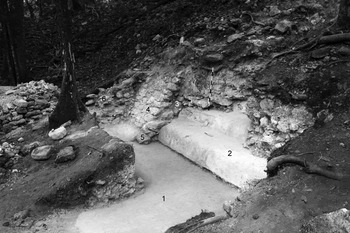
Beyond the unexpected discovery of the Late Preclassic platform beneath Structure 27, excavations also revealed a complicated building sequence between the construction of the platform and the final phase of the superstructure. Renovations included sequentially-constructed battered surfaces within a presumably inset stair of the Late Preclassic platform. These were subsequently covered by later renovations, including the final version of the stairway of Structure 27. Overall, at least six construction phases are apparent, with the latest represented by the final range building and the earliest by a well-preserved plaster surface extending beneath the stepped Late Preclassic platform (Figure 6). Because none of the battered surfaces were removed during excavation, neither ceramic artifacts nor organic matter were recovered to date these sequential architectural phases. However, the quality of masonry became subjectively poorer from oldest to youngest, with cut stone blocks becoming less standardized and more irregularly positioned over time. This suggests that renovations to Structure 27 took place gradually, perhaps beginning as early as the Early Classic, and that the building was likely functioning for many centuries prior to La Milpa's abandonment.
Oblique photograph of Structure 27 excavations showing architectural renovations (1 = earliest, 6 = latest). 1: well-preserved plaster floor initially identified in 2007; 2: buried Late Preclassic multi-tiered platform; 3–5: battered surfaces within presumed inset stair; 6: Late-to-Terminal Classic stair. View to the southwest.

Plaza B
Excavations targeted each of the range structures on the north, west, and south sides of Plaza B, the Structure 21 pyramid to the east, and the plaza surface itself (Houk and Zaro Reference Houk and Zaro2010, Reference Houk and Zaro2011). Ceramic analysis identified predominantly TR-Tepeu-2 and 3 ceramic types from most overburden and building collapse contexts, corroborating previous conclusions regarding a Late-to-Terminal Classic phase of construction for the latest architecture surrounding the plaza (Hammond and Tourtellot Reference Hammond, Tourtellot, Demarest, Rice and Rice2004). However, our results also indicate that, while there is some evidence of unfinished construction projects, most of the buildings surrounding Plaza B had not only been completed, but had witnessed significant architectural renovation prior to La Milpa's abandonment.
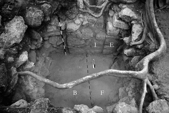
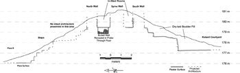
Excavation of range buildings (Structures 20/23, 22, and 24) was designed to partially expose their latest construction phase and to determine their degree of architectural completion. Coupled with surface morphology, the results of our excavations indicate that Structure 22 is a simple range building, while Structures 20/23 and 24 are both tandem range buildings with thick spine walls. Each of the three buildings had undergone some degree of renovation prior to La Milpa's abandonment. Exposed floor surfaces in Structure 24 reveal several re-plastering episodes, while an interior wall in Structure 22 was constructed as part of a renovation project that included raising a portion of the floor to the surface of a pre-existing bench (Figure 7). A small test pit on Structure 23 also revealed a complex construction history, exposing part of a buried wall and fill beneath a Late-to-Terminal Classic floor surface (Figure 8). Unfortunately, no datable material was recovered from the small sampling area within this test pit. Work along Structure 23's summit also identified intentionally infilled rooms and it was determined that the southern half of the building had been covered with large cobble and boulder fill. While this final renovation to Structure 23 does not appear to have been completed, the predominance of TR-Tepeu 2–3 ceramics from overburden, collapse, and construction fill contexts suggest a Late-to-Terminal Classic period for both the latest construction and expansion project. While earlier constructions cannot be dated with the information currently available, it is clear that, along with each of the other range structures surrounding Plaza B, Structure 23 had been completed and was undergoing renovation prior to abandonment. Presumably, range buildings lining Plaza B and Courtyard D served the royal family in some capacity, perhaps administratively, domestically, or both; unfortunately, the artifactual record offers few clues as to their purpose, since none of our excavations encountered in situ artifacts within rooms.
Renovations to Structure 22. Dashed line indicates the resulting seam from raising the plaster floor (F) to the surface of the bench (B). While the exterior wall segment (E) penetrates the raised floor surface, the interior partition (I) does not, suggesting it was added contemporaneously or subsequent to raising the floor. View to the north.

Cross-section of Structure 23 showing location of buried wall from earlier structure, infilled rooms on summit, and dry-laid boulder fill on southern face of structure.

It is perhaps worth noting here that LaMAP documented similar infilled rooms in the Southern Acropolis. Hammond et al. (Reference Hammond, Tourtellot, Everson, Sagebiel, Thomas and Wolf2000:42) note that Structures 38 and 39 were apparently filled and reoriented to face south, rather than north. Neither remodeling episode was ever completed, however.
Additional architectural information comes from Structure 21, the imposing 18 m-high mound on the east side of Plaza B. Its apparent lack of superstructure, front stair, and masonry facing led to previous conclusions that Structure 21 was abandoned prior to completion (Hammond et al. Reference Hammond, Tourtellot, Donaghey and Clarke1998:833). Our summit excavations encountered dry-laid, cobble-sized rocks merging into large cobble and boulder fill immediately beneath the surface. However, approximately 65 cm below surface we revealed a buried structure (Structure 21-Sub), including several wall foundations toward the center of the summit, a rear terrace along its eastern margin, and the uppermost 15 steps of the western face of the building (Figure 9). A vertical joint or seam is evident in the stairs, where those to the south of the seam appear to be of higher quality construction and more regularly positioned than those to the north of the seam. There is also a subtle change in alignment between the two phases of construction, possibly suggesting the seam represents a renovation project that included widening the front stairway.
Photograph of Structure 21-Sub stairs (plan view) and south profile. In the photograph, north is towards the bottom of the image; the dashed line indicates a seam identified during excavation and mentioned in the text.

These results are in accordance with previous conclusions that the visible phase of Structure 21 was never completed (Hammond et al. Reference Hammond, Tourtellot, Donaghey and Clarke1998:833). Curiously, we did not identify any nearby stock piles of building materials, such as cut stones reserved for continued renovation of the platform, or other indicators of ongoing construction (e.g., ramps, bins). Rather, it appears that Structure 21-Sub, after an unknown period of use, had its superstructure demolished before the entire substructure was intentionally buried in preparation for a new construction; this latest phase, however, was never fully completed. While our excavations did not penetrate Structure 21-Sub, TR-Tepeu 2–3 ceramics recovered from overburden and the large cobble and boulder fill immediately beneath the surface indicate this latest expansion was instituted during the Late-to-Terminal Classic period. Whether or not earlier buildings lie beneath Structure 21-Sub remains unknown.
Tenth Century Component
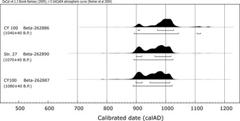
Evidence for a tenth century component stems from construction and other activity contexts. In addition to Late Preclassic monumental architecture with subsequent renovations, excavation of Structure 27 also revealed that final construction activity likely persisted into the tenth century. A charcoal sample (Figure 10) recovered from beneath the latest floor surface of the Structure 27 range building returned an uncalibrated radiocarbon age of 1070 ± 40 b.p. (Beta-262890) with a 2σ calibrated age range of a.d. 890–1030. Unfortunately, our excavations only exposed a small portion of the entranceway to the Structure 27 summit room and therefore could not assess whether in situ artifacts associated with the final use of the building are present. Consequently, based on this limited evidence, we cannot state with confidence that these rooms were void of in situ artifacts in similar fashion to range buildings surrounding Plaza B (see above).
La Milpa Core Project radiocarbon probability distributions for 14C dates mentioned in the text. All samples are originally reported in Houk (Reference Houk and Houk2010:Table 2).

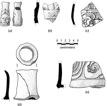
Elsewhere in the southern plazas area, the small Courtyard 100 just east of Structure 21 yielded additional information that indicates tenth century activity. The group consists of a series of low mounds arranged around the north, west, and south sides of a small courtyard, and a low wall or partition defining the eastern margin. Most notable of our excavations is a 1 m-wide trench situated perpendicular to and overlying the low wall defining the eastern margin of the courtyard. The wall is oriented north-south, though several smaller perpendicular partitions are also noted, suggesting an intentional separation of space, possibly for distinct activities or storage. Excavations encountered dense artifact depositsFootnote 1 on both sides of the north-south divide, but particularly so outside the courtyard (east side). Ceramic vessel sherds were most common, but fragments of lithic bifaces, debitage, obsidian, ceramic drum fragments, ceramic whistles and/or flutes, and faunal remains were also recovered (Figure 11). Two peccary bone fragments (Leslie Shaw, personal communication, 2009) from this deposit yielded uncalibrated radiocarbon ages of 1040 ± 40 b.p. and 1080 ± 40 b.p., with 2σ calibrated age ranges of a.d. 895–1040 and a.d. 890–1020, respectively (see Figure 10).
Ceramic artifacts from Courtyard 100 deposits. (a) Flute fragment; (b) figurine or ocarina fragment; (c) Pabellon Modeled-carved; (d) ceramic drum fragment, Palmar Group; (e) Torro Gouged-incised: Variety unspecified. All illustrations by Jenni Gutzeit, except (c), illustrated by Jennifer Bryan.

A test pit placed in the adjacent Courtyard 100B also recovered dense artifactual material and could represent a termination deposit similar to those excavated at other sites in the region (see Adams et al. Reference Adams, Robichaux, Valdez, Houk, Mathews, Demarest, Rice and Rice2004; Houk Reference Houk and Houk2000; Sullivan et al. Reference Sullivan, Houk and Valdez2007, Reference Sullivan, Hageman, Houk, Hughbanks, Valdez, Stanton and Magnoni2008). While full analysis of this material is pending, a single Pabellon Modeled-carved sherd was identified during excavation. This ceramic type is an important Terminal Classic period diagnostic (see Sabloff Reference Sabloff1975:198), and the design—the left profile of a man wearing an earspool, necklace, and headdress—is a common motif on fine orange and imitation fine orange vessels (see Coe [Reference Coe1965], Houk [2000], and Sabloff [1975] for examples). In addition, Lauren Sullivan (personal communication, 2010) tentatively identified the presence of two striated sherds similar to Buyuk or Aventura Striated, dated to a.d. 750–1150 (Sidrys Reference Sidrys1983).
The combination of Terminal Classic ceramics and three radiocarbon dates strongly suggests continued occupation of La Milpa into the tenth century, perhaps anywhere from three to nine generations beyond previous estimates for an early ninth century site abandonment. Moreover, identification of building modification and other activities that date to the tenth century likely points to continued occupation of particular sectors within the site core, rather than post-abandonment squatter activity.
SUMMARY AND DISCUSSION
The results of our work offer three points of refinement to the previously conceived growth curve of the La Milpa monumental core. First, its Late Preclassic monumental beginnings, previously believed to be confined to the Great Plaza area, included some portions of the southern plazas region. While the high degree of overburden and late phase constructions at the site limit any real assessment of the extent of the Late Preclassic built environment, the presence of a Late Preclassic platform buried beneath Structure 27 and Late Preclassic ceramics reported by Sagebiel (Reference Sagebiel2005) around Reservoir B suggest there may be significant potential for similar discoveries elsewhere in the southern sectors. Second, the number of architectural renovations to Structure 27 indicates incremental growth in the constructed landscape over the centuries prior to the Late-to-Terminal Classic period, though this certainly does not preclude the possibility of a historical gap between the Late Preclassic platform and subsequent renovations. However, the presence of sequential architectural modifications does indicate that in some cases—perhaps even many cases—Late-to-Terminal Classic expansion projects had significant foundations upon which to build. This was clearly the case with Structure 21 where an apparently incomplete final phase covered a pre-existing penultimate structure. Hence, the late phase expansion of La Milpa, while still ambitious, may not represent the explosive growth in construction volume formerly hypothesized. Finally, it appears that occupation in the southern plazas area continued well beyond the previously proposed early ninth century abandonment, evidenced by three tenth century radiocarbon dates from both construction and depositional contexts. This suggests that occupation may have lasted upwards of three to nine generations beyond previous estimates for site abandonment.
This modified growth curve of La Milpa's built environment has implications for regional population models in the Three Rivers region, how we understand ancient Maya political history and abandonment surrounding La Milpa, and the growing picture of Terminal Classic variability in the Central Lowlands. Embedded within these implications are the precision and accuracy of the ceramic sequence upon which these interpretations are often made. Though certainly integrated themes, we address these separately in the following discussion.
Regional Population Models
In a recent study, Adams et al. (Reference Adams, Robichaux, Valdez, Houk, Mathews, Demarest, Rice and Rice2004:Table 15.1) drew upon survey data from the area surrounding La Milpa to generate population curves for the region. They identified a long period of growth during the Late Preclassic, followed by a rapid decline in the Early Classic 1 period and subsequent boom into the Early Classic 2–3 periods. A second population decline—about a 75% crash—appears to have occurred at the end of the Early Classic 3 period, but was again followed by another dramatic increase over the course of a little more than a century during the Late Classic 2 period. Both of these growth spurts, it is argued, likely resulted from a combination of in situ population growth and immigration from outside the area (Adams et al. Reference Adams, Robichaux, Valdez, Houk, Mathews, Demarest, Rice and Rice2004:330–332). Elsewhere in the Three Rivers region, Hageman and Lohse (Reference Hageman, Lohse, Scarborough, Valdez and Dunning2003:112) emphasize that “…many of the largest sites (with the notable exception of Blue Creek) were only lightly occupied through the end of the Late Classic 1 (a.d. 550–650)…[but that] much of the region experienced unusually rapid population growth during Late Classic 2 (a.d. 650–850).” Furthermore, they note that this growth is reflected in both rural settlement and many major monumental centers.
While our work at La Milpa corroborates major expansion projects in the Late-to-Terminal Classic period, it also suggests these constructions likely accrued more gradually during the Classic period, and with a more significant Late Preclassic foundation. Occupation across the Three Rivers landscape is clearly most pronounced during the Late-to-Terminal Classic period, but data pertaining to earlier construction histories remain scarce. If this same trend is true of other sites in the region, then the previously proposed population curves are likely misleading. Consequently, the peaks and troughs of population boom and bust cycles were, in all likelihood, less dramatic. As a result, it may not be necessary to look to immigration to explain the Late Classic population growth.
A contributing factor to the abruptness of the apparent Late Preclassic decline is now believed to be a ceramic issue. As Sullivan and Sagebiel (Reference Sullivan, Sagebiel, Scarborough, Valdez and Dunning2003:28) observe, “problems in detecting Early Classic settlement include the possibility that some Late Preclassic ceramic types appear to continue in use throughout the Early Classic.” In particular, there is a continued use of waxy red slips, typical of the Late Preclassic, on Early Classic ceramic forms in the region (Sullivan and Valdez Reference Sullivan and Valdez2006:79). Therefore, the Late Preclassic peak and subsequent Early Classic decline in population may have been overstated (Sullivan and Sagebiel Reference Sullivan, Sagebiel, Scarborough, Valdez and Dunning2003; Sullivan and Valdez Reference Sullivan and Valdez2006).
We suspect that a similar situation may be contributing to the Late-to-Terminal Classic phase of the population curve. As Hammond and Tourtellot (Reference Hammond, Tourtellot, Demarest, Rice and Rice2004:297–298) have lamented previously (and as we discuss above), the resolution of the ceramic chronology in the region is not precise enough to permit a reliable separation of TR-Tepeu 2 and TR-Tepeu 3. Were it possible to separate the two spheres more precisely, we suspect the outcome would mimic our results from the built environment: still peaking at the end of the Late Classic, but with a more gradual rise and less precipitous decline.
Ancient Maya Political History and Abandonment of La Milpa
Settlement data in the area show that some sites were settled as early as the Middle Preclassic, but excavation and survey data from across the region have demonstrated that settlement expanded dramatically during the Late Preclassic (Adams et al. Reference Adams, Robichaux, Valdez, Houk, Mathews, Demarest, Rice and Rice2004:332–333). The monumental core of La Milpa, now demonstrated to have extended into the southern plazas area, is consistent with pronounced Late Preclassic settlement. If the built environment, and particularly as it relates to monumental architecture, can be interpreted to reflect political clout at La Milpa, then clearly the Late Preclassic rulers were more politically savvy in their appropriation and direction of labor during this early period than previously believed.
What little is known about individual Early Classic rulers from the region stems only from carved stelae and painted tombs at Rio Azul. The origins of the Rio Azul dynasty may lie with Tikal, which is believed to have conquered the former polity about a.d. 385 and to have installed a ruling lineage there (Adams Reference Adams1999:139). Rio Azul was probably the dominant site in the Three Rivers region during the Early Classic, but may have been sacked and largely abandoned by a.d. 530 (Adams Reference Adams1999:143, 145). When coupled with conclusions drawn by previous researchers at La Milpa, our data support gradual growth during this period, and, based on ceramic data from both elite and non-elite contexts, a strong Peten influence may have been a factor (Sagebiel Reference Sagebiel2005:732). In addition, Adams et al. (Reference Adams, Robichaux, Valdez, Houk, Mathews, Demarest, Rice and Rice2004:335) interpret the evidence to suggest that La Milpa was part of the Tikal regional state during this time. Moderate growth in monumental architecture (evidenced in part by successive renovations to Structure 27) may not signify strengthening political authority, but it does likely indicate, minimally, a steady maintenance of power by La Milpa's ruling class. While our sample size is small, the evidence does point to the ability of the site's rulers to continue directing labor towards a moderate expansion of monumental architectural complexes.
La Milpa may have emerged as the dominant site in the Three Rivers region during the second century of the Late Classic period. At Rio Azul, Stela 2 possibly mentions a visit to Rio Azul by a ruler from La Milpa sometime between a.d. 690–721 (Robichaux Reference Robichaux and Adams2000:43). It is significant that it makes no mention of Tikal, but possibly cites La Milpa's double emblem glyph (this identification is rather tentative as the glyphs in question are damaged [Robichaux Reference Robichaux and Adams2000:41]). Adams (Reference Adams1999:178) suggests that after a.d. 690, Rio Azul likely lost its role as an administrative center, perhaps falling below La Milpa and Kinal in the regional hierarchy.
While not as ambitious as previously believed, La Milpa clearly experienced significant growth ca. a.d. 700–800. Most structures and plazas visible today were either built or refurbished during this period, evidenced by the predominance of TR-Tepeu 2–3 ceramic types associated with the latest phase of construction (Hammond and Tourtellot Reference Hammond, Tourtellot, Demarest, Rice and Rice2004; Sagebiel Reference Sagebiel2005; Schultz et al. Reference Schultz, Gonzalez and Hammond1994). Grube (Reference Grube1994) reads a partial text on La Milpa's Stela 7, dated to a.d. 780, as identifying a Late Classic ruler named Ukay, who may have been associated with much of this expansion. Though questions regarding the variability in La Milpa's political growth through much of the Classic period cannot be resolved with currently available information, it is clear that the prowess of La Milpa's dynastic lineage peaked during the Late-to-Terminal Classic period. It also seems likely that the political authority of La Milpa's ruling family was inextricably linked to processes beyond the Three Rivers region, but supported by a network of smaller sites nearby that included Dos Hombres, Gran Cacao, Blue Creek, Wari Camp, Ixno'ha, Maax Na, and others.
After its peak, La Milpa and its ruling family began to decline in power, ultimately concluding with the abandonment of the site and surrounding countryside. At issue, currently, is the nature of life at La Milpa in the years or decades between political apogee and abandonment and the timing of that final abandonment. Clues to both can be found in the built environment, which offers scholars a relatively static snapshot of the archaeological record. It is clear that La Milpa, like all ancient and modern cities, was in a state of continuous change for about a millennium of occupational history. As Webster (Reference Webster2002:155) points out, Maya cities probably resembled other urban landscapes across our planet, constantly undergoing phases of construction, renovation, or decay. This is perhaps most apparent in La Milpa's matrix of unfinished public works, ongoing expansion projects, and small scale renovations during the polity's final phase of occupation.
The unfinished public works present the greatest challenge for understanding the abandonment of the site. Hammond and Tourtellot (Reference Hammond, Tourtellot, Demarest, Rice and Rice2004) view the unfinished state of Structure 21 as evidence for rapid abandonment of La Milpa, but that conclusion assumes a continuous construction process. However, as they also point out, “…we have little idea of the ‘normal’ pace of such efforts, and whether multiple projects involving different kinds of buildings would have been simultaneously pursued…” (Hammond and Tourtellot Reference Hammond, Tourtellot, Demarest, Rice and Rice2004:300). Indeed, the timing and duration of the renovation of large buildings such as Structure 21 remain unknown. However, if the abandonment of the renovation project was sudden, we would expect to see piles of building materials nearby. Yet, this is not the case with Structure 21; rather, it appears as if the construction project proceeded in stages—the demolition of the superstructure of Structure 21-Sub, the burial of Structure 21-Sub by large boulder fill, etc.—that may have taken place months if not years apart. Scheduling each stage was likely a matter of balancing labor availability with the demands of multiple construction and maintenance projects within some long-term plan for completing the final structure (such as timing the completion to correspond to a significant date). Failing to complete the structure could be related to the abandonment of La Milpa, or it could just as easily be related to a change in planning agenda or construction priorities, such as might occur with a new ruler's ascension to the throne. While archaeological signatures of expansion projects like in situ construction ramps, partially-faced platforms, or stockpiled materials may tell us much about the mechanics of construction itself and the abrupt nature of abandonment (Inomata et al. Reference Inomata, Ponciano, Chinchilla, Román, Breuil-Martínez and Santos2004), other cases like that of Structure 21 offer few clues as to the process or timing of construction and abandonment. If anything, we propose that the lack of those features associated with Structure 21 indicate a prolonged process—one that might have advanced purposefully in discrete stages over time.
While the rate of abandonment remains difficult to gauge, the clean states of rooms around Plaza B suggest that La Milpa was not likely abandoned chaotically in the face of sociopolitical catastrophe. Excavations failed to recover any in situ artifacts within range buildings, which may indicate a gradual or prolonged period of abandonment of La Milpa's monumental core, where people continued to clean out the contents of these monumental structures for a period of time after their functional role had ceased. Regardless of the rapidity of abandonment, the clean state of rooms would minimally indicate an orderly departure that was not rushed. It is clear, however, that these rooms were never occupied again, suggesting their abandonment, regardless of the process, was permanent. Nonetheless, the combination of cleaned rooms, a tenth century component, and unfinished construction projects requires a new model of explanation.
Taking this evidence into consideration, we suggest a new scenario for La Milpa's final days that includes significantly diminished political prowess, but perhaps not a complete disintegration, accompanied by continued occupation of La Milpa by some members of the royal family into the tenth century. In this case, site abandonment likely did not occur concurrently with a significant decline in political clout. Rather, while the presence of large, unfinished public works projects might suggest rapid abandonment, it may only signal: (1) that the royal family or ruling members of La Milpa lost their ability to appropriate significant amounts of labor for such constructions, or (2) that ruling members actively dismissed corveé labor obligations for a hiatus, perhaps as a result of the hardships commonly experienced more broadly during the Terminal Classic period. In either case, while the surviving members of the ruling class may not have been able to negotiate these monumental works to completion, they were able to continue calling upon skilled laborers and craftspeople in the maintenance and renovation of Structure 27, and in the production and/or appropriation of specialty craft items such as ceramic whistles and drums, like those recovered in the Courtyard 100 deposits.
Without a predominance of iconic Terminal Classic ceramics or other chronometric measures related to these abandoned large-scale public works projects, it is difficult to argue that these were instituted any later than the early ninth century. On the other hand, given the evidence, it would be equally difficult to explain artifact accumulation in Courtyard 100 and minor renovations to Structure 27 without suggesting a tenth century component. Combined with the clean states of royal palaces and/or administrative buildings surrounding Plaza B, the evidence points to the persistence of a reduced faction of elite society at La Milpa for some time after the royal family experienced a significant decline in political power.
Variation in the Terminal Classic
The revised history of La Milpa adds to the growing picture of Terminal Classic variability and complexity in the Central Lowlands. While we see similarities in the final century or so of La Milpa's occupation to events at other centers, in many ways the differences are more informative and compelling.
In addition to Hammond's (Reference Hammond1999) work at La Milpa, researchers have documented the intentional infilling of elite residences prior to site abandonment at a number of centers in the eastern part of the Central Lowlands, including Xunantunich (LeCount et al. Reference LeCount, Yaeger, Leventhal and Ashmore2002), Minanha (Iannone Reference Iannone2005), and Lamanai (Graham Reference Graham2004), leading Morris et al. (Reference Morris, Iannone and Awe2007:5) to conclude that “the effacement of both the physical and social ruling houses of many lowland centers” was one of the first consequences of the “infamous Maya collapse.” Each situation mentioned above, however, has its own unique set of characteristics and suggests that different forces were in play at the various sites.
At Xunantunich, LeCount et al. (Reference LeCount, Yaeger, Leventhal and Ashmore2002:44) propose that a number of Terminal Classic construction projects were initiated in response to Xunantunich's achieving independence from Naranjo, including the abandonment of the royal compound. The process, however, was “orderly and nonviolent,” with most floors and rooms swept clean and at least one structure having its walls partially dismantled and its room filled with debris (LeCount et al. Reference LeCount, Yaeger, Leventhal and Ashmore2002:44).
A similar scenario has been proposed for Minanha, which, like Xunantunich, was a petty kingdom on the periphery of more powerful centers (Iannone Reference Iannone2005). At Minanha, the rooms of the royal residential compound were carefully filled and the courtyard itself buried. The resulting surface was used as a “comparatively mundane Terminal Classic courtyard,” which Iannone (Reference Iannone2005:34–37) suggests was occupied by some group other than the former royal house of Minanha. A sparse Terminal Classic population persisted at the site for some time after the fall of the royal family, but the occupation was less conspicuous than during the Late Classic period (Iannone Reference Iannone2005:37).
At both Xunantunich and Minanha, the Terminal Classic modifications to royal compounds were non-violent, yet still believed to be linked to political transitions immediately preceding the abandonment of the centers. At Lamanai, the situation is somewhat different. Graham (Reference Graham2004) reports Terminal Classic infilling of a courtyard and Structure N10-77, which was preceded by the extensive burning of the rooms' contents. The infilled architecture served as the platform for Structure N10-12, also a Terminal Classic building, which was subsequently razed and modified during the Early Postclassic period (Graham Reference Graham2004:239). The Lamanai example stands in stark contrast to those of Xunantunich and Minanha because of the continued occupation of the site into the Postclassic period.
At La Milpa, we believe the infilled buildings recorded by our work in the southern plazas and by Hammond et al. (Reference Hammond, Tourtellot, Everson, Sagebiel, Thomas and Wolf2000) in the Southern Acropolis are related to the other unfinished construction projects at the site. They represent the initial steps in abandoned projects to expand or renovate structures (Pendergast Reference Pendergast1990:69). The overall picture is of a weakened royal family, one that either lost the ability to continue multiple renovations and expansions or chose to direct the labor under their command to other tasks while still managing to persist for several generations during the Terminal Classic period at La Milpa. The fairly extensive renovations to Structure 27 show that occupation and construction continued despite the fact that many projects were left unfinished.
CONCLUSION
Major construction began in La Milpa's southern plazas as early as the Late Preclassic period, and buildings were incrementally expanded and modified, apparently for centuries. Plaza B became a functioning element of the royal precinct by the Late Classic period, if not earlier, while several of its structures show evidence of unfinished renovations and expansions, with Structure 21's incomplete renovation being the most significant. While additional 14C dates would be helpful in assessing late-phase occupation at La Milpa, the three tenth-century dates presented here from multiple contexts make a compelling argument for some degree of occupation extending beyond ca. a.d. 900. While the specific nature of this late-phase occupation remains unknown, the combination of unfinished monumental works, continued small-scale construction or renovation, and cleaned rooms in royal palaces and administrative buildings may signal rapid decline in political clout, but not necessarily a total and complete loss of power. Consequently, La Milpa's abandonment appears to have been a gradual process, one that likely lasted three to nine generations beyond its initial decline in governance.
This newly proposed model for La Milpa's decline requires a re-evaluation of the Terminal Classic ceramic chronology and models of regional population history, as some of our data contradict the accepted span of TR-Tepeu 3 ceramics at La Milpa and in the Three Rivers region (e.g., Sagebiel Reference Sagebiel2005; Sullivan and Sagebiel Reference Sullivan, Sagebiel, Scarborough, Valdez and Dunning2003). In their discussion of Terminal Classic period variability across the Maya Lowlands, Webster and colleagues (Reference Webster, Freter, Storey, Demarest, Rice and Rice2004:257) address La Milpa's abandonment, somewhat ironically noting that the originally proposed ninth century date “assumes that the chronological duration of the last major ceramic complex is well controlled.” The ceramic chronology in the Three Rivers region, particularly for the Terminal Classic period, relies extensively on cross-dating with sites outside the area. If our data correctly reflect occupation and construction around Plaza B as late as the tenth century, then a re-evaluation of the Tepeu 3 ceramic phase in the region is in order. Because regional population models, which project explosive TR-Tepeu 2–3 population growth in major site and hinterland contexts, are based almost exclusively on ceramic chronology, they too would require re-evaluation.
RESUMEN
El ascenso y el consiguiente colapso de la civilización maya clásica siguen siendo problemas complejos. Con la descripción de más secuencias históricas locales y regionales del cambio en la región de los mayas, la complejidad de estos procesos se hace más evidente. Estudios de los mayas suelen utilizar los períodos de crecimiento y estancamiento en monumentos construidos para interpretar la naturaleza dinámica de las políticas mayas. Aunque quizás no sea una medida ideal, la historia de la construcción de los antiguos centros mayas refleja la apropiación de trabajo y prosperidad, y tal vez pueda servir indirectamente como una medida del crecimiento y declive de la influencia política. Además, la trayectoria de cambio a través del tiempo puede identificar períodos de crecimiento rápido, estancamiento relativo, declive, o aun colapso. En este escenario, la precisión y la exactitud con las que se puede medir el crecimiento y la disminución del paisaje construido por los antiguos mayas se vuelven de gran importancia. En el sitio arqueológico de La Milpa, Belice, nuestras excavaciones durante las últimas tres temporadas han producido información que requiere una nueva evaluación de la trayectoria histórica originalmente propuesta para este sitio. En este trabajo se presentan nuevos datos del centro monumental de La Milpa, los cuales cambian la perspectiva de su ascenso histórico hacia su apogeo de la época preclásica tardía (ca. 400 a.C.–250 d.C.) a la época clásica tardía/terminal (ca. 600–900 d.C.) y los períodos de su abandono posterior. Los resultados de nuestro trabajo sugieren que, mientras que la fase de construcción y expansión más notable ocurrió muy tarde durante el octavo siglo o en las primeras décadas del siglo nueve de nuestra era, parece haber habido una acumulación más gradual del núcleo monumental antes de dichas expansiones. Nuestros datos también sugieren que el abandono de La Milpa ocurrió en el siglo diez—décadas o incluso siglos después de la fecha ya propuesta para el abandono de La Milpa a partir de 830 d.C.
ACKNOWLEDGMENTS
We would like to recognize the staff of the Institute of Archaeology in Belmopan, Belize, for their continued support of our work at La Milpa. This research was supported in large part by a grant from the Research Enhancement Fund of Texas Tech University, and authorized by permits assigned to the Programme for Belize Archaeological Project under the direction of Fred Valdez, Jr. We would like to especially thank Fred Valdez, Jr., Liwy Grazioso, Débora Trein, and Kerry Sagebiel for their helpful suggestions and discussion, and Lauren A. Sullivan for her ceramic expertise and collaboration during laboratory analysis and write-up. We also thank Norman Hammond, Laura J. Kosakowsky, Fred Valdez, Jr., and two anonymous reviewers for their willingness to read and offer constructive comments on an earlier draft of this paper, and Carrie Dennett and the Ancient Mesoamerica editorial staff for their hard work in helping to bring this manuscript to publication. Finally, students of the Texas Tech University and University of Texas at Austin field schools invested significant time and energy in field excavations and laboratory research, without which the ideas presented here would not have been developed. Of course, any errors or omissions are strictly our own.