


Non-technical Summary
Birds foraging on the margins of lakes, rivers, and oceans produce unique traces (biogenic structures) on the sediment surface. This paper describes the traces that various foraging behaviors produce in order to aid with interpreting similar features in the rock record. Biogenic structures emplaced by a bird’s bill or beak include peck marks, probe marks, gape marks, dabble marks, and sweep marks. Biogenic structures emplaced by a bird’s feet include stir tracks, paddle pits, and trample grounds. The traces made by these behaviors are described in this paper, with key features for their identification and interpretation described. Examples of some of these traces from the rock record are provided, but many have not yet been correctly interpreted in ancient successions.
Introduction
Marginal marine and marginal lacustrine settings host an exceptionally diverse array of birds, particularly shorebirds and other waterbirds (Zweers and Gerritsen, Reference Zweers and Gerritsen1997; Ntiamoa-Baidu et al., Reference Ntiamoa-Baidu, Piersma, Wiersma, Poot, Battley and Gordon1998; Beninger, Reference Beninger2018; Mathot et al., Reference Mathot, Piersma, Elner and Beninger2018). Abundant and diverse food resources in these settings offer unparalleled opportunities for foraging and provide essential fuel for migrations that often span thousands of kilometers (e.g., Burger et al., Reference Burger, Howe, Hahn and Chase1977, Reference Burger, Niles and Clark1997; Elner et al., Reference Elner, Beninger, Jackson and Potter2005; Mathot et al., Reference Mathot, Lund and Elner2010; Kuwae et al., Reference Kuwae, Miyoshi, Hosokawa, Ichimi, Hosoya, Amano, Moriya, Kondoh, Ydenberg and Elner2012; Mu and Wilcove, Reference Mu and Wilcove2020; Hall et al., Reference Hall, Del La Cruz, Woo, Kuwae and Takekawa2021). Marginal marine and marginal lacustrine successions have similarly been crucial settings for waterbird aggregation since the middle Mesozoic (e.g., Lim et al., Reference Lim, Zhou, Martin, Baek and Yang2000; Lockley et al., Reference Lockley, Matsukawa, Ohira, Li, Wright, White and Chen2006; Anfinson et al., Reference Anfinson, Lockley, Kim, Kim and Kim2009; Falk et al., Reference Falk, Hasiotis and Martin2010; Falk, Reference Falk2011; Fiorillo et al., Reference Fiorillo, Hasiotis, Kobayashi, Breithaupt and McCarthy2011; Kim et al., Reference Kim, Lockley, Seo, Kim, Kim and Baek2012, Reference Kim, Kim, Oh and Lee2013; Abbassi et al., Reference Abbassi, Kundrát, Ataabadi and Ahlberg2015).
Despite the importance of marginal lacustrine and intertidal flats for migrating waterbirds (e.g., Recher, Reference Recher1966; Burger and Olla, Reference Burger and Olla1984; Colwell and Oring, Reference Colwell and Oring1988; Wilson, Reference Wilson1991; Burger et al., Reference Burger, Niles and Clark1997; Colwell, Reference Colwell2010; Beninger, Reference Beninger2018; Mathot et al., Reference Mathot, Piersma, Elner and Beninger2018; Melnyk et al., Reference Melnyk, Cowper, Zonneveld and Gingras2022a, Reference Melnyk, Lazowski and Gingras2022b) and excellent representation of these settings in the rock record (e.g., Carmona et al., Reference Carmona, Bournof, Ponce, Cuadrado, Noffke and Chavetz2011; Zonneveld et al., Reference Zonneveld, Zaim, Rizal, Ciochon, Bettis, Aswan and Gunnell2011, Reference Zonneveld, Zaim, Rizal, Ciochon, Bettis, Aswan and Gunnell2012; Cuadrado et al., Reference Cuadrado, Maisano and Quijada2021; Lockley et al., Reference Lockley, Kim, Lim and Romillo2021), few reports have discussed the feeding structures produced in sediment by bird activities in either environment in the modern. With a few exceptions (e.g., Swennen and van der Baan, Reference Swennen and van der Baan1959; Elbroch and Marks, Reference Elbroch and Marks2001; Table 1), particularly for some unique and unusual behaviors (e.g., Cadée, Reference Cadée1990; Gregory, Reference Gregory1999; Gihwala et al., Reference Gihwala, Pillay and Varughese2017; Melnyk et al., Reference Melnyk, Lazowski and Gingras2022b), most previous work that discusses modern marginal aquatic foraging behavior is devoid of illustrations of the traces that are produced.
Studies that have discussed modern shorebird foraging behavior and illustrated biogenic structures related to these activities

Invertebrate traces are commonly reported occurring alongside avian ichnofossil assemblages (e.g., Ellenberger, Reference Ellenberger1980; Krapovickas et al., Reference Krapovickas, Ciccioli, Mángano, Marsicano and Limarino2009; de Valais and Cónsole-Gonella, Reference de Valais and Cónsole-Gonella2019), however trace fossils attributed to avian feeding activities have rarely been reported. Rare exceptions come from the Cretaceous of South Korea and the western USA (Lockley et al., Reference Lockley, Chin, Houck, Matsuwaka and Kukihara2009; Falk et al., Reference Falk, Hasiotis and Martin2010; Lockley and Harris, Reference Lockley, Harris, Ulrich and Willett2010; Kim et al., Reference Kim, Lockley, Seo, Kim, Kim and Baek2012), the Cenozoic of Argentina (Melchor et al., Reference Melchor, Bedatou, de Valais and Genise2006, Reference Melchor, Cardonatto and Visconti2012; Genise et al., Reference Genise, Melchor, Archangelsky, Bala, Straneck and de Valais2009), the Eocene Green River Formation (Yang et al., Reference Yang, Lockley, Greben, Ericksen and Lim1995; Lockley et al., Reference Lockley, Kim, Lim and Romillo2021; Zonneveld et al., Reference Zonneveld, Naone and Britt2025), the Miocene of Iran (Abbassi et al., Reference Abbassi, Kundrát, Ataabadi and Ahlberg2015), and the late Eocene of Indonesian Borneo (Zonneveld et al., Reference Zonneveld, Zaim, Rizal, Aswan, Ciochon, Smith, Head, Wilf and Bloch2024). The limited recognition of avian ichnofossils is due, at least in part, to the paucity of detailed descriptions and illustrations of biogenic sedimentary structures emplaced during modern avian feeding and foraging. Neoichnological descriptions are essential for accurate identification and interpretation of biogenic sedimentary structures in ancient successions (e.g., Dashtgard and Gingras, Reference Dashtgard, Gingras, Knaust and Bromley2012; Hembree, Reference Hembree2016; Zonneveld, Reference Zonneveld2016; Brewer and Falk, Reference Brewer and Falk2021).
This study is focused on providing descriptions and interpretations of biogenic sedimentary structures generated during the feeding and foraging activities of waterbirds and other birds that frequent aquatic and marginal aquatic settings. The goal is to build on the expansive avian behavioral literature and bridge the current gap between neo-ethological analyses and ichnological/paleoecological studies. It is anticipated that with clear illustrations of common bird foraging and feeding traces, these structures will be more commonly recognized in intertidal and marginal lacustrine successions in the rock record.
Materials and methods
This project uses a number of different methods and incorporates observations of bird feeding during neo-ichnological analyses at numerous localities over the past decade in North America, including Craig Bay and Semiahmoo Bay (British Columbia), Gull Lake and Beaverhill Lake (Alberta), Antelope Island (Great Salt Lake, Utah), Shepody (New Brunswick), Petitcodiac River (New Brunswick), Selma (Nova Scotia) Hartley Bay/Copper River Delta area, Alaska, as well as The United Arab Emirates at Qantur Lagoon, Abu Dhabi (Fig. 1, Table 2). Seventy-seven species of primarily shorebirds and waterbirds were observed feeding in marginal aquatic settings at these localities (Table 3).
Location map showing the marginal marine and marginal lacustrine study locations discussed in this paper (indicated by green stars). (1) Map of North America showing the location of North American study sites. (2) Hartley Bay and Copper River Delta, Alaska. (3) Map of Alberta showing the locations of Gull Lake (i), Beaverhill Lake (ii), Cooking Lake (iii), and Lesser Slave Lake (iv). (4) Map of British Columbia showing the locations of Craig Bay (i) and Semiahmoo Bay (ii). (5) Map of the southern Canadian maritime provinces showing the locations of the Petitcodiac River (i), Economy Point (ii), Selma (iii), and Shepody (iv). (6) Map of Georgia showing the location of the Ogeechee Estuary. (7) Map of Washington showing the location of Willapa Bay. (8) Map of Utah showing the location on Antelope Island in the Great Salt Lake. (9) Map of the Arabian Gulf region showing the Qantur Lagoon study area, Abu Dhabi.

Study areas, bird taxa, and foraging behaviors observed in this study

Taxonomic names of birds, invertebrates, and trace fossils discussed in this paper

Birds were observed through binoculars and through telephoto lens. Foraging and feeding activities were monitored, and then the location was visited after the birds had vacated. Care was taken to avoid disturbing the birds during foraging and feeding activities. Still images of all foraging- or feeding-related activities were captured photographically using a Canon EOS 5D Mark II full frame camera equipped with a Canon EF 100–400 mm f/4.5–5.6L zoom lens with optical image stabilization.
Traces produced by foraging birds were photographed and, where possible, their dimensions (length, width, depth of penetration, and thickness of fill) were measured. In all study localities physical evidence of foraging and feeding that were not visually linked to the activities of specific birds were also observed. These biogenic structures are also described and photographed, and their most likely makers identified where possible.
Traces emplaced under water in intertidal settings were measured and described after exposure at low tide. When necessary and where accessible, the water depth of aquatically emplaced traces was measured directly using a folding ruler. Where the site could not be directly accessed (primarily to avoid unduly disturbing migratory waterbirds) water depth was estimated based on assessing the proportion of the bird’s leg immersed in the water relative to average species body size. Although imprecise, absolute depths were not needed for this project and this method sufficed.
Traces were measured with calipers or a foldable, meter-scale ruler, whichever was more appropriate. Trace depths were assessed using a ruler or a thin metal probe, depending on their size. Although small traces were measured to the nearest millimeter and larger traces to the nearest centimeter, absolute, precise sizes were not necessary because the shapes, and proportional dimensions are more important. As well, most traces discussed herein were emplaced in soft to soupy sediment and, consequently, some collapse or infilling naturally occurred after removal of the bill or foot.
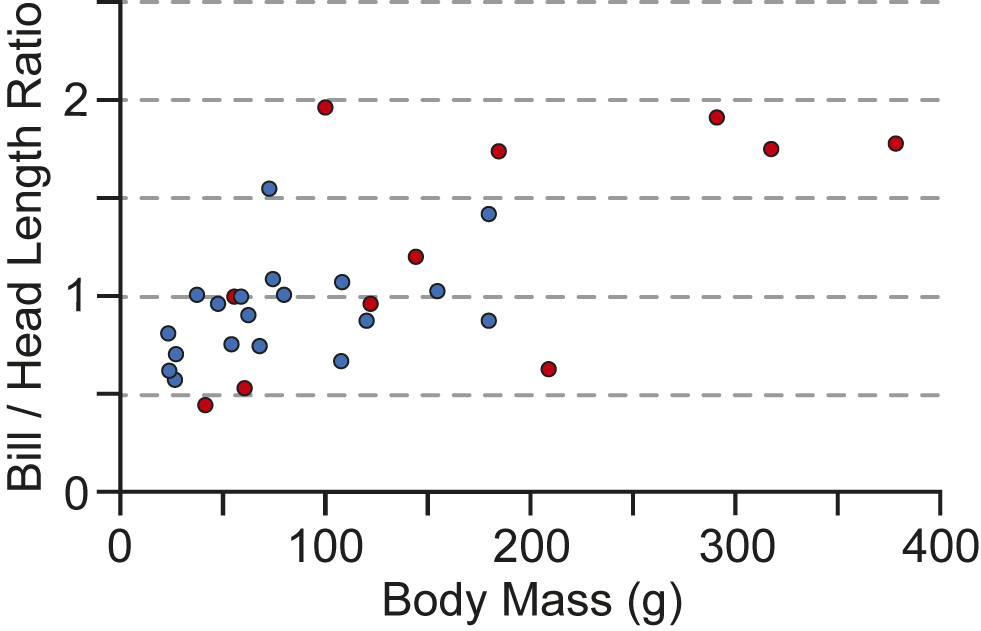
Bill-to-head ratios were calculated for 30 shorebird taxa (selected from Kuwae et al., Reference Kuwae, Miyoshi, Hosokawa, Ichimi, Hosoya, Amano, Moriya, Kondoh, Ydenberg and Elner2012, supplementary information). This ratio was calculated by obtaining five images of the head of each taxon from reputable sources on the internet (most commonly the allaboutbirds.org website run by the Cornell Lab of Ornithology) and from shorebird texts, calculating the bill-to-head ratio, and averaging the results. These results were then compared graphically, depending on which bird taxa have tongue spines (obtained from Kuwae et al., Reference Kuwae, Miyoshi, Hosokawa, Ichimi, Hosoya, Amano, Moriya, Kondoh, Ydenberg and Elner2012) and which ones do not, in order to illustrate a relationship between body size, proportional bill length, and the occurrence of tongue spines, which are utilized in biofilm feeding.
For selected sites in North America, areal images were taken ~3–5 m above the sediment surface with a DJI Mavic 2 Pro quadrotor drone equipped with a Hasselblad L1D-20c camera (4000 × 3000 pixels; 72 dpi). Surface orthomosaics of waterbird trackways associated with biogenic structures related to foraging at Selma and Shepody, Nova Scotia, have been published elsewhere (Melnyk et al., Reference Melnyk, Cowper, Zonneveld and Gingras2022a).
We augmented our field observations with photographs of aquatic and marginal aquatic bird foraging discovered during literature and web searches to ensure that we illustrated the broadest possible variety of traces produced by shorebird foraging activities. In most cases, the absolute size and depth of these traces could not be precisely assessed, however their overall morphology and the relationship of foraging traces to footprints and trackways are clearly discernible.
It is worth noting that the study sites were the locations of a succession of neo-ichnological investigations that initially focused on the invertebrate assemblages. Consequently, the invertebrate faunas were also studied using a variety of techniques including surface grid studies, trenching, vibracoring, box coring, shovel surveys, and spot surveys using clam guns. These techniques have been summarized in numerous other papers (e.g., Gingras et al., Reference Gingras, Pemberton, Saunders and Clifton1999, Reference Gingras, Pemberton and Saunders2001, Reference Gingras, Dashtgard, MacEachern and Pemberton2008a, Reference Gingras, Pemberton, Dashtgard and Dafoeb; Dashtgard and Gingras, Reference Dashtgard and Gingras2005, Reference Dashtgard, Gingras, Knaust and Bromley2012; Pearson et al., Reference Pearson, Gingras, Armitage and Pemberton2007; Hauck et al., Reference Hauck, Dashtgard and Gingras2008; Dashtgard et al., Reference Dashtgard, Pearson, Gingras, Martini and Wanless2014; Zonneveld et al., Reference Zonneveld, Gingras, Hodgson, McHugh, Myers, Schoengut, Wetthuhn, Hembree, Platt and Smith2014; Shchepetkina et al., Reference Shchepetkina, Gingras and Pemberton2015, Reference Shchepetkina, Gingras and Pemberton2016a, Reference Shchepetkina, Gingras, Zonneveld and Pemberton2016b) and are not reiterated here because they are not the primary focus of the present work. Invertebrate fauna identified in this study are listed in Table 1.
Repositories and institutional abbreviations
The modern traces discussed herein were photographed in the field. Photographs are archived in the ichnology collections at the University of Alberta. Trace fossil specimens examined in this study are deposited in the following institutions: University of Alberta Ichnology Collections (UA-ZC), Institut Teknologi Bandung, ITB-M, University of Colorado Museum (UCM), or Brigham Young University (BYU).
Study sites
The feeding activity and the biogenic sedimentary structures, produced primarily by waterbirds and crows, were observed in the field in a number of sites in North America and at one site on the southern shore of the Arabian Gulf (Fig. 1). Sites studied include freshwater lacustrine, saline lacustrine, brackish intertidal, and hypersaline intertidal localities (Table 2).
Freshwater lacustrine sites
Waterbirds at four freshwater lacustrine study locales are included herein (Table 2): Gull Lake, Beaverhill Lake, Cooking Lake, and Lesser Slave Lake, all in the province of Alberta, Canada (Fig. 1.3). Field observations at Gull Lake were made in September 2018 and focused on feeding traces emplaced by Western Sandpiper (Calidris mauri). Ring-billed gulls (Larus delawarensis) were also observed in the field. The water level at Gull Lake reaches its annual high in May or June, gradually dropping through the summer and into the early fall, rendering extensive damp sand flats available to migrating waterfowl.
Field observations at Beaverhill Lake, Alberta, occurred in May 2006 and focused specifically on the biofilm-feeding behavior of Baird’s Sandpiper (Calidris bairdi). Field observations at Cooking Lake, Alberta, occurred in August 2023, and involved Baird’s Sandpiper, Greater Yellowlegs (Tringa melanoleuca), and Lesser Yellowlegs (T. flavipes). Various dabbling ducks were also observed at Cooking Lake but were not observed foraging. Field observations at Lesser Slave Lake focused on gulls, dunlins, and sandpipers during late spring, summer, and early fall of 2020 and 2021. In addition to waterbirds, American crows (Corvus brachyrhynchos) were also observed foraging along the shores of Lesser Slave Lake.
Hypersaline lacustrine sites
A single hypersaline lake site is included in this study (Table 2). Field observations on the Great Salt Lake at Antelope Island, Utah (Fig. 1.6), occurred in May 2018 and focused on the American Avocet (Recurvirostra americana), Willet (Tringa semipalmata), Black-necked Stilt (Himantopus mexicanus), Snowy Plover (Charadrius nivosus), and Western Sandpiper. Multiple other shorebird taxa, including Ring-billed Gull, European Herring Gull (Larus argentatus), California Gull (Larus californicus), Black-headed Gull (Chroicocephalus ridibundus), Black-necked Grebe (Podiceps nigricollis), and American Coot (Fulica americana) were also observed. Observations were conducted on the northern part of Antelope Island, from the causeway connecting the highland to the mainland, to Bridger Bay and White Rock Bay. Water levels in the Great Salt Lake reached a historic high in the mid-1980s and have been dropping for the past several decades (Jewell, Reference Jewell2021) leaving extensive mud and oolitic sand flats along the island margins.
Marginal marine sites
Marginal marine study locales in this project occur on both the Pacific and Atlantic coasts of Canada, on the Pacific coast of Alaska, and on the shores of the Ogeechee estuary in Georgia (Fig. 1.2, 1.4, 1.5, 1.6; Table 2). Field work at Craig Bay was undertaken in all seasons and during multiple years, from 2010 to 2020. Craig Bay, located on the Salish Sea coast on the eastern side of Vancouver Island (Fig. 1.4), is an upper mesotidal ridge-and-runnel complex with extensive sand flat exposure during low tide (Hale and McCann, Reference Hale and McCann1982; Zonneveld et al., Reference Zonneveld, Gingras, Hodgson, McHugh, Myers, Schoengut, Wetthuhn, Hembree, Platt and Smith2014). Craig Bay is a crucial stopover for multiple shorebird and waterbird taxa (Eamer, Reference Eamer1985; Crewe et al., Reference Crewe, Barry, Davidson and Lepage2012). Taxa commonly observed during field research include Western Gull (Larus occidentalis), Western Sandpiper (Calidris mauri), Bufflehead (Bucephala albeola), Greater Scaup (Aythya marila), American Wigeon (Mareca americana), Mallard (Anas platyrhynchos), Black Oystercatcher (Haematopus bachmani), Brant or Brent Goose (Branta bernicla), and Great Blue Heron (Ardea herodias). In addition to these shorebird and waterbird taxa, Northwestern Crow (Corvus caurinus) and Bald Eagle (Haliaeetus leucocephalus) were also observed feeding in the intertidal zone.
Field observations at Semiahmoo Bay, on the southeastern margin of the Salish Sea (Fig. 1.4) were conducted in September 2021. As with Craig Bay, Semiahoo Bay provides a crucial stopover point for many migrating shorebird taxa. A single Glaucous-winged Gull (Larus glaucescens) was recorded via drone while foraging during an ebbing tide (Melnyk et al., Reference Melnyk, Lazowski and Gingras2022b). The resultant trace was described and photographed after the gull had vacated the area. Additional similar traces were also photographed and described. Field observations have been ongoing at Willapa Bay, Washington (Fig. 1.7), since 1996. Herein we include observations of a Golden Eagle (Aquila chrysaetos) in the Willapa Bay intertidal made in July 2023.
Field observations at the Bay of Fundy occurred in September 2019, and focused on several different localities, including tidal flats along the Petitcodiac River in New Brunswick, intertidal mudflats at the Shepody River mouth, New Brunswick, and tidal flats at Selma and Economy Point, Nova Scotia (Fig. 1.5). The Bay of Fundy is a characterized by one of the largest tidal ranges in the world (up to 12 m). Direct observation was made of several taxa including Semipalmated Plover (Charadrius semipalmatus), Semipalmated Sandpiper (Calidris pusilla), American Crow (Corvus brachyrhynchos), Sanderling (Calidris alba), American Black Duck (Anas rubripes), and Great Blue Heron (Ardea herodias).
Field observations at the Ogeechee Estuary (Fig. 1.6) occurred in July 2006. The Ogeechee Estuary has a tidal range of approximately 1.5 meters, with moderately extensive mudflats occurring on the margins of the estuary. Direct observation was made of Little Blue Heron (Egretta caerulea) foraging on channel margin sandflats in the lower part of the upper intertidal zone in very low salinity water (~5‰).
Field observations at Qantur Lagoon, Abu Dhabi, on the southern shore of the Arabian Gulf (Fig. 1.9) occurred in November 2021. The study locality is in southwestern Abu Dhabi, on intertidal flats between Qantur Island and the mainland. Field observations focused on the activities of the Greater Flamingo (Phoenicopterus roseus) although the Common Sandpiper (Actitis hypoleucos) and the Greater Sand Plover (Charadrius leschenaultii) were also observed in the field. Shorebirds were primarily observed in the lower and middle intertidal zones, seaward of extensive algal/cyanobacterial mats, in mesosaline waters (55–65‰).
Terminology
The biogenic structures discussed herein commonly occur adjacent to avian tracks and trackways. In this contribution, the terms ‘tracks’ or ‘prints’ refer to individual footprints whereas the terms ‘trackways’ or ‘series’ refer to two or more associated, typically sequential footprints. We use the words ‘mark’ and ‘trace’ in the broader, non-genetic sense (sensu Zonneveld et al., Reference Zonneveld, Fiorillo, Hasiotis and Gingras2022). These words become constrained when modifying phrases are added to them (e.g., claw mark, scratch mark, trace fossil, etc.). We most commonly use the word ‘trace’ to denote a complete biogenic feature, whereas the word ‘mark’ or ‘marking’ denotes a component of a biogenic feature such as a claw mark at the end of an avian footprint or a beak mark emplaced adjacent to a trackway. This is consistent with the way these terms are used in the avian behavioral literature (e.g., Swennen and van der Baan, Reference Swennen and van der Baan1959; Elbroch and Marks, Reference Elbroch and Marks2001).
Most birds observed in this study are either shorebirds or other types of waterbirds. The term ‘shorebird’ is limited to birds of the order Charadriiformes (Burger and Olla, Reference Burger and Olla1984; Colwell, Reference Colwell2010; Chandler, Reference Chandler2017) whereas ‘waterbird’ is a more informal term and includes a variety of birds that live on or near water (including shorebirds). Several avian taxa that fall outside the ‘waterbird’ umbrella (such as crows and eagles) were also observed foraging in marginal lacustrine and marginal marine areas and are discussed in this paper.
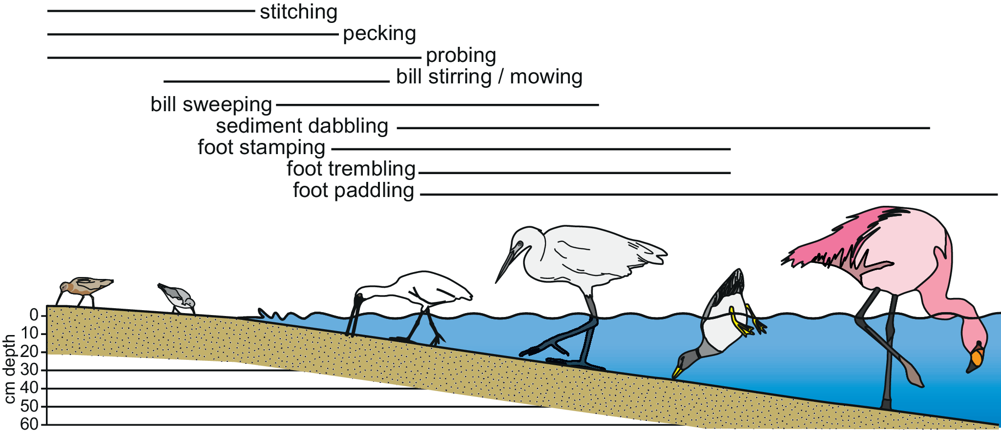
Waterbirds forage using a wide variety of methodologies (e.g., Hamilton, Reference Hamilton1975; Davis and Smith, Reference Davis and Smith2001; Kelly et al., Reference Kelly, Gawlik and Kieckbusch2003; Estrella et al., Reference Estrella, Masero and Pérez-Hurtado2007; Dias et al., Reference Dias, Granadeiro and Palmeirim2009; Rico-Guevera et al., Reference Rico-Guevara, Sustalta, Gussekloo, Olsoen, Bright, Corbin, Dudley, Bels and Whishaw2019) (Figs. 2–5). In this contribution we discuss only those that leave physical evidence in the sedimentary record. This includes foraging behaviors that involve the bill alone and others that involve movement of a bird’s feet. Some of these terms are vaguely defined in the literature. Others have multiple, sometimes contradictory, definitions, which are outlined below.
Feeding strategies in intertidal flat and lake margin settings. (1) Pied Oystercatcher (Haematopus longirostris) probing saturated sand for prey with gaped beak, southwestern Australia. This behavior results in paired oval probe marks in mud and sand. (2) Common Greenshank (Tringa nebularia) probing for prey, Gower, Wales. This behavior produces a single, deep, roughly circular pit. (3) Black-tailed Godwit (Limosa limosa) probing deeply into intertidal mud, Titwell Marsh, Norfolk, United Kingdom. (4) A pair of American Avocet (Recurvirostra americana) on the margin of the Great Salt Lake, Antelope Island, Utah pecking at brine flies. This behavior leaves clusters of singular and solitary circular to oval pits. (5) Long-billed Curlew (Numenius americanus) foraging in the Elkhorn Slough National Estuarine Research Reserve, Monterey Bay, California. (6) Black-faced Spoonbill (Platalea minor) sweeping in shallow intertidal water, Hong Kong, China. (7) Common Teal (Anas crecca) foraging on mudflats along the shores of the River Tyne, Great Britain. Note the pock-marked surface surrounding the Teal, the result of foraging by this and other individuals. Photograph by Wikimedia contributor MPF, used under license through Creative Commons 2.0. (8) James’s Flamingo (Phoenicoparrus jamesi) stamp-feeding on the edge of Laguna Colorado, Bolivia. Photograph by Valdiney Pimenta, used under license through Creative Commons 2.0.

Pecking, probing, gaping, and dabbling by waterbirds. (1) Schematic of a plover-like bird pecking at the sediment surface in a subvertical orientation. Note that only the tip of the bill enters the sediment. (2) Sketch of a shorebird pecking at the substrate surface with an open bill, resulting in a paired peck mark. (3) Sketch of a shorebird pecking at the surface while walking, resulting in an oblique interaction of the bill with the sediment surface. (4) Schematic of a shorebird probing deep into a muddy substrate. (5) Sketch of a bird using distal rhynchokinesis or gaping to create a void in the sediment surface. (6) Close-up sketch of a shorebird using distal rhynchokinesis. (7) Sketch of a probing shorebird using “sewing-machine” behavior where the tip of the bill leaves the sediment between individual probes (adapted from Sibley, Reference Sibley2019). (8) Sketch of a probing shorebird using “stitching” behavior where the tip of the bill remains within the sediment between individual probes. The bill is removed from the sediment at regular intervals between probe clusters (adapted from Sibley, Reference Sibley2019). (9) Waterbird wading in shallow water on an intertidal mud flat, grasping mouthfuls of sediment, filtering the food out, and producing ovoid dabble marks. (10) Swimming waterbird up-ended and sediment-dabbling at the sediment–water interface.

Sweeping by shorebirds. (1) Face-down sweeping by the Black-faced Spoonbill (Platalea minor). (2) Face-down sweeping by the American Avocet (Recurvirostra americana). (3) Side-swipe sweeping by the American Avocet (Recurvirostra americana).

Foot-facilitated foraging by waterbirds. (1–3) Foraging by an egret in shallow water: (1) foraging by walking slowly forward; (2) as each foot is lifted, the egret shakes it in a stirring motion; (3) prey are disturbed from cover and the bird lunges forward to grab them. (4–6) Biogenic structures created via foot-paddling: (4) gull paddling and moving backwards, creating crude off-lapping packages of sediment fill (after Melnyk et al., Reference Melnyk, Lazowski and Gingras2022b); (5) development of a crater-like structure through gull foot-paddling during a falling tide in which the nature of the motion of the gull and its feet results in settling of sediment on an apron surrounding a central, circular pit; (6) flamingo foot-paddling in a circle, producing ring-like structures in which the motion of the feet suspends sediment in the water column, which settles on the central mound.

Pecking and stabbing
Some bill-focused foraging behaviors, such as pecking and stabbing, are dominantly visual techniques. Although stabbing at prey rarely leaves a physical trace in the substrate, pecking commonly does. Pecking has been defined as foraging behavior where the bill touches the surface of the substrate or penetrates the sediment by less than one-quarter of its bill length (Streefkerk, Reference Streefkerk1960; Burton, Reference Burton1974; Hamilton et al., Reference Hamilton, Barbeau and Diamond1975; Puttick, Reference Puttick1979; Barbosa and Moreno, Reference Barbosa and Moreno1999; Nol et al., Reference Nol, MacCulloch, Pollock and McKinnon2014; Touhami et al., Reference Touhami, Idrissi and Benhoussa2020). For the purposes of this paper, peck marks are defined as shallow traces in the sediment surface with depths no greater than their width. Peck marks can have a variety of morphologies, depending on the shape of the beak and the orientation of the bill movement. With stop-and-peck foraging the bill strikes the sediment surface vertically to subvertically (Fig. 3.1, 3.2), whereas during peck-on-the-run foraging the bill strikes the sediment surface obliquely (Fig. 3.3).
Under most definitions, pecking involves the bird obtaining food items identified through visual cues. However, if pecking is defined by proportional bill penetration, is not necessarily a visual foraging technique. For example, the Dunlin (Calidris alpina) commonly uses randomized pecking and shallow stitching (discussed below) as a tactile foraging tactic (Burton, Reference Burton1974; Mouritsen and Jensen, Reference Mouritsen and Jensen1992). Although their bills are typically greater than 25 mm in length, dunlins on Wadden Sea intertidal mudflats were observed to forage tactilely, inserting their bills 1–3 mm into the sediment surface, which coincided with the average depth of burial of their dominant prey (Mouritsen and Jensen, Reference Mouritsen and Jensen1992).
Probing
Probing involves insertion of the bill over one-quarter (or one-third) of its length into the substrate (Hamilton, Reference Hamilton1975; Grant, Reference Grant1984; Ward and Bulloch, Reference Ward and Bullock1988; Piersma et al., Reference Piersma, van Gils, de Goeji and Van Der Meer1995; Barbosa and Moreno, Reference Barbosa and Moreno1999; Finn et al., Reference Finn, Catterall and Driscoll2008; Touhami et al., Reference Touhami, Idrissi and Benhoussa2020) (Fig. 3.4, 3.7, 3.8). Shallow penetration (up to 50% bill insertion) has been referred to as ‘jabbing’ (Holmes, Reference Holmes1966; Burton, Reference Burton1972, Reference Burton1974; Grant, Reference Grant1984; Dann, Reference Dann1999), however jab marks are not differentiable from probe marks, so they are both referred to as probe marks. Although probing is commonly attributed to thin-billed shorebirds (Fig. 2.1–2.4), waterbirds with wide bills may also utilize probing behavior in soft and soupy substrates (Fig. 2.7).
Probing behavior commonly involves regular, systematic behavior that results in emplacement of evenly spaced, systematic traces (Fig. 3.7, 3.8). Criteria that control the occurrence, style, and abundance of probing include substrate type, substrate consistency, prey type, and prey abundance (Grant, Reference Grant1984; Piersma et al., Reference Piersma, van Gils, de Goeji and Van Der Meer1995; Finn et al., Reference Finn, Catterall and Driscoll2008). Pierre (Reference Pierre1994) limited probing to when the bird foraged more slowly and inserted more than 50% its bill into the sediment, and referred to shallower, rapid probing as ‘tapping’. Similar behavior has been reported by other workers as sewing machine-like (Fig. 3.7) or stitching action (Burton, Reference Burton1971, Reference Burton1972, Reference Burton1974; Hulscher, Reference Hulscher1976; Kelsey and Hassall, Reference Kelsey and Hassall1989; Weber and Haig, Reference Weber and Haig1997; Rylander, Reference Rylander2002). Stitching has also been limited by some authors as a technique in which the bird inserts the entire bill into the substrate, moves forwards slowly, bobbing its head up and down without ever fully removing the bill from the substrate (Ward and Bulloch, Reference Ward and Bullock1988; Nol et al., Reference Nol, MacCulloch, Pollock and McKinnon2014) (Fig. 3.8), however it is clear that most authors use the term in the broader sense, to refer to any rapid series of jabs (Burton, Reference Burton1971, Reference Burton1972, Reference Burton1974; Hulscher, Reference Hulscher1976; Kelsey and Hassall, Reference Kelsey and Hassall1989; Weber and Haig, Reference Weber and Haig1997; Rylander, Reference Rylander2002). We refer to closely spaced, systematic groupings of probe marks as ‘stitch marks’ herein.
Gaping
Gaping (Fig. 3.5, 3.6) is conducted when a bird inserts its closed bill into sediment or vegetation, or beneath an object, and opens it to create an opening in the sediment/vegetation or to dislodge/move the object (e.g., Cruz, Reference Cruz1978; Orians, Reference Orians1983). Gaping, in the strictest sense, is a common behavior of icterid Passeriformes and involves enhanced bill-opening musculature (Cruz, Reference Cruz1978; Orians, Reference Orians1983). Rhynchokinesis involves opening of a portion of the bill, commonly the distal tip (Bühler, Reference Bühler, King and McLelland1981; Zusi, Reference Zusi1984; Elbroch and Marks, Reference Elbroch and Marks2001; Estrella and Masero, Reference Estrella and Masero2007), which may occur within the sediment, resulting in a similar trace to those produced by gaping (Fig. 3.5, 3.6). Elongate traces in the sediment are referred to herein as ‘gape marks’. Gape marks are a subset of probe marks, and it is acknowledged that some purported gape marks may simply be probe marks of birds with bills that are oval in outline.
Dabbling
Dabbling is a commonly used, albeit rarely defined, term for a foraging strategy employed by anatid waterbirds. The most common usage refers to swimming or wading birds removing food from the surface of the water, commonly aided by surface tension transport, without submersing the eyes (e.g., Rubega and Obst, Reference Rubega and Obst1993; Rubega, Reference Rubega1997; Johnson and Rohwer, Reference Johnson and Rohwer2000). This foraging behavior is not preserved in the sediment record and is not discussed further herein.
‘Dabbling’ has also been used to describe the activity of some anatid waterbirds (such as Shelduck) wherein they grasp mouthfuls of sediment and sieve it with their lamellae for prey (Olney, Reference Olney1965; Bryant and Lang, Reference Bryant and Lang1975; Thompson, Reference Thompson1981, Reference Thompson1982; Walmsley and Moser, Reference Walmsley and Moser1981; Viain et al., Reference Viain, Corre, Delaporte, Joyeux and Bocher2011). In this usage the bird’s bill is below the water, in contact with the sediment–water interface (Fig. 3.9), and, in deeper water, is accompanied by head-dipping or upending (Fig. 3.10) (Bryant and Lang, Reference Bryant and Lang1975; Thompson, Reference Thompson1981, Reference Thompson1982; Viain et al., Reference Viain, Corre, Delaporte, Joyeux and Bocher2011). The resultant traces have been referred to as ‘dabble marks’, ‘dabbling holes’, and ‘dabble craters’ (Swennen and van der Baan, Reference Swennen and van der Baan1959; Olney, Reference Olney1965; Thompson, Reference Thompson1981, Reference Thompson1982). To separate the two terms, we refer to the latter behavior as ‘sediment dabbling’, with the resultant sedimentary structures referred to as ‘dabble marks’. These features are consistent with the sole previous illustration of a dabble crater (Thompson, Reference Thompson1981).
Scraping
Scraping involves placing the lower mandible on the substrate surface and pushing it forward directly in front of the bird (Hamilton, Reference Hamilton1975). After each scrape the bird tends to lift its head and swallow (Hamilton, Reference Hamilton1975). Scraping was not observed in this study and is not discussed further.
Sweeping
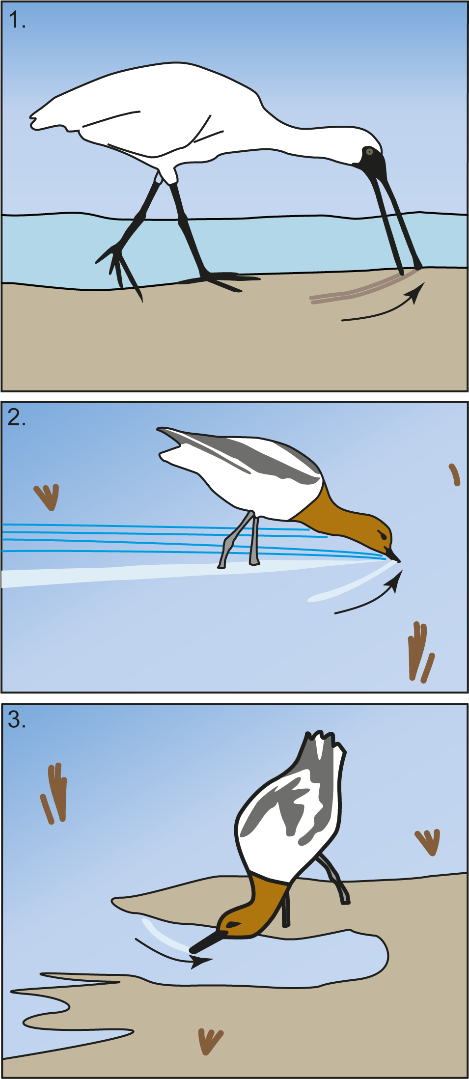
Sweeping involves lateral movement of the bird’s bill through water or across the sediment surface (e.g., Swennen and van der Baan, Reference Swennen and van der Baan1959; Olney, Reference Olney1965; Hamilton, Reference Hamilton1975; Bühler, Reference Bühler, King and McLelland1981; Zusi, Reference Zusi1984; Barbosa and Moreno, Reference Barbosa and Moreno1999; Elbroch and Marks, Reference Elbroch and Marks2001; Colwell, Reference Colwell2010; Nol et al., Reference Nol, MacCulloch, Pollock and McKinnon2014). Sweeping most commonly involves birds foraging in a face-down orientation, with the bill oriented perpendicular to sub-perpendicular to the sediment surface (Fig. 4.1, 4.2), however some taxa (such as avocets) were observed to sweep by rotating their head and sweeping with their bills dragged in a recumbent position, sub-parallel to the sediment surface (Fig. 4.3). Sweeping is also referred to in some studies as scything (e.g., Hamilton, Reference Hamilton1975; Quammen, Reference Quammen1982; Velasquez, Reference Velasquez1992; Cavitt, Reference Cavitt2006). Hamilton (Reference Hamilton1975) separated scything into three categories: single scything, multiple scything, and dabble scything. Single scything involves a single pass over the substrate whereas multiple scything involves back-and-forth motion. Both occur on either wet mud or in shallow water. Dabble scything is similar to single scything but occurs while the bird is wading or swimming in deeper water.
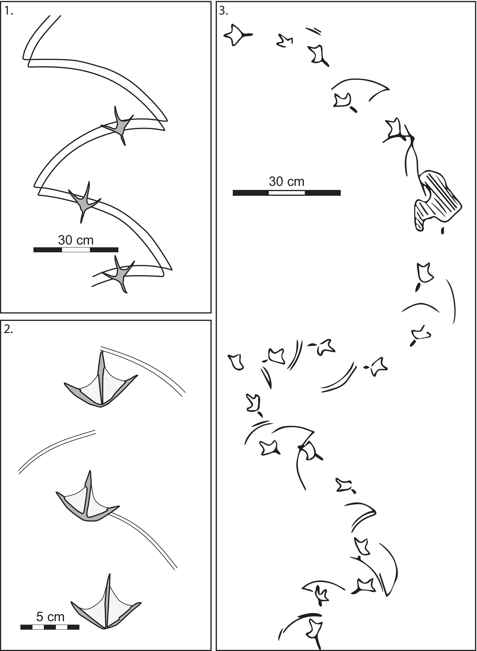
Sweeping/scything, as discussed herein, involves regular movement over a broad arc, typically exceeding 40° of arc, with the length of resultant grooves exceeding the width of associated tracks and trackways. A related behavior, herein termed ‘bill stirring’, involves arcuate to swirling movement over a much narrower range of arc (<10°). Traces resulting from stirring are typically narrower than associated footprints or trackways emplaced by the trace-making shorebird or waterbird but may be as much as twice the width of the individual footprints. Bill stirring commonly involves complete reworking of the sediment in a very narrow trend.
An intermediate behavior has been termed ‘mowing’ (Swennen and van der Baan, Reference Swennen and van der Baan1959). Mowing involves arcuate loops within the sediment surface to the left and right of a trackway (Swennen and van der Baan, Reference Swennen and van der Baan1959). This behavior produces a trace that has been described as “fern leaf” trails (Swennen and van der Baan, Reference Swennen and van der Baan1959; Olney, Reference Olney1965). Mowing has also been referred to as an action carried out while walking wherein the bill is held in a vertical position, with its tip in contact with the sediment and the head moved side-to-side. Bill stirring, sweeping, and mowing are related behaviors, differentiated solely on the extent and nature of the movement of the bill. All three are tactile foraging behaviors wherein a shorebird or waterbird uses its bill to locate food resources in the water or sediment. In this study we observed broad sweep marks with wide (40°) arcs and large unbioturbated areas between each pass and restricted stir marks with narrow arcs (<10°) and full bioturbation within their trends.
Foraging traces involving feet
Evidence of waterbird foraging may also result from traces emplaced by feet. Many birds walk through shallow water or on subaerially exposed sediment regularly probing or sweeping for prey, a process termed ‘walk-feeding’ (Bildstein et al., Reference Bildstein, Frederick and Spalding1991; Glassom and Branch, Reference Glassom and Branch1997; Beauchamp, Reference Beauchamp and Anderson2017). Foot-trembling birds shuffle their feet with a quivering motion, slowly advancing through the sediment and stabbing at any prey that might be disturbed into motion (Meyerriecks, Reference Meyerriecks1959, Reference Meyerriecks1971; Willard, Reference Willard1977; Chandler, Reference Chandler2017) (Fig. 5.1–5.3). Foot-trembling has been reported for some lapwing species, some egret species, and many plover species, but has not been commonly reported for other species (Chandler, Reference Chandler2017).
Foot-stamping involves stamping the feet up and down in order to disturb the substrate to facilitate feeding (Petrie and Petrie, Reference Petrie and Petrie1998). Foot-stamping behavior observed in this study typically involves a significant reduction in normal stride length (measured from a landmark on one footprint to an identical landmark on the next, same-side footprint in the series). A variety of anatid and charadriiform waterbirds have been reported to utilize foot-stamping as a foraging tactic (e.g., Petrie and Petrie, Reference Petrie and Petrie1998; Tatu et al., Reference Tatu, Anderson, Hindman and Seidel2007; Zelenskaya, Reference Zelenskaya2021).
Foot-paddling (also termed trample-kneading and stamp-feeding) involves birds stirring up the sediment with their feet to locate buried prey or resuspend organics in the water (Tinbergen, Reference Tinbergen1962; Burger, Reference Burger1988; Cadée, Reference Cadée1990; Hendricks and Hendricks, Reference Hendricks and Hendricks2006). Gulls may foot-paddle in discrete spots, resulting in circular craters (Fig. 5.4) or they may foot-paddle in a sinuous to linear trend resulting in an elongate trough (Fig. 5.5) (Swennen and van der Baan, Reference Swennen and van der Baan1959; Cadée, Reference Cadée1990, Melnyk et al., Reference Melnyk, Lazowski and Gingras2022b). Flamingo foot-paddling commonly results in ring-shaped troughs on intertidal flats (Fig. 5.6) (Gallet, Reference Gallet1950; Bildstein et al., Reference Bildstein, Frederick and Spalding1991; Glassom and Branch, Reference Glassom and Branch1997).
In shallow, submerged settings, foot-stamping and foot-paddling are related behaviors in which the feet are used to dislodge or startle food items/prey from the sediment. Foot-stamping results in linear trackways, typically with overlapping footprints, whereas foot-paddling results in troughs and pits with completely reworked sediment.
Results
Freshwater lacustrine sites
The sediment at Gull Lake in the area studied consisted of very fine-grained to fine-grained sand. Chironomid larvae and exuviae were observed scattered randomly on the surface of the sediment. Vegetative wrack was common, and biofilm was abundant on the sediment surface. The Ring-billed Gull (Larus delawarensis) occurs in abundance, commonly in flocks exceeding 75 birds. Gull tracks were commonly observed adjacent to low mats of wrack composed of grasses and seaweed, but their foraging did not produce markings in subaerially exposed sediment within or adjacent to the mats.
Three gulls were observed pecking at, and commonly removing prey items (typically bivalves) at the sediment surface, resulting in large, shallow, roughly triangular to ovoid peck marks (Fig. 6.1). Several gulls were also observed conducting foot-paddling behavior in shallow (8–12 cm) water. The site where this behavior was observed was revisited either later the same day or on the subsequent day, after the gulls had vacated the location. Large circular craters were routinely observed where foot-paddling behavior had occurred (Fig. 6.2). The craters ranged in size from 16–24 cm in diameter, surrounded by a low-relief (5–10 cm) ring-like apron. The base of the crater was, in general, 3–5 cm deeper than the adjacent lake bottom. It is not known what prey the gulls pursued in these areas, although the lake does host freshwater bivalves and gastropods.
Foraging structures emplaced by Ring-billed Gull (Larus delawarensis) at Gull Lake, Alberta. (1) Tridactyl palmate footprints adjacent to peck marks in the sand (arrows). (2) Crater-like pits in shallow water emplaced by foot-paddling gulls (arrows). Pit in foreground is 35 cm across.

Baird’s Sandpiper (Calidris bairdi) at Gull Lake were observed foraging along the water’s edge (Fig. 7.1, 7.2), frequently pecking at the moist sediment surface. During field observations only the tip of the beak was immersed in the sediment (i.e., much less than one-fourth of bill length). Most commonly the birds pecked at the ground as they continuously wandered, following an erratic, meandering pathway. On two small islands, sandpipers were observed to walk back and forth continuously pecking at the surface, apparently covering the same small area repeatedly. The peck marks were circular to subcircular hemispherical depressions in the sediment surface (Fig. 7). On several occasions, the sandpipers were observed to stop walking and stand in one spot, shifting their feet only slightly, while repeatedly probing more deeply. The sandpipers commonly foraged alone, or in groups of two or three. Analyses of the feeding grounds (after the sandpipers had moved on) revealed several different biogenic features on the sediment surface. The two small islands mentioned above were covered in dimpled surfaces with abundant tiny roughly circular peck marks with diameters of ~1.5–2.5 mm and depths commonly < 1 mm (Fig. 7.3–7.8). The sand in which the extensive pecking occurred was rich in a biofilm composed primarily of algae and bacteria. Digging into the shallow sand both within and adjacent to the dimpled area did not reveal any prey organisms, thus it is presumed that the dimple ground records biofilm feeding. Deeper probe marks (up to 4 mm) occurred in the same area as the shallow peck marks, many of which were clearly paired (Fig. 7.4, 7.6–7.8). Commonly, the probe marks occur in dense clusters of overlapping marks (Fig. 7.7, 7.8). A number of oval marks were also observed (Fig. 7.3–7.5), which likely represent gape marks. These commonly had a plug of pushed-up sediment at one end (Fig. 7.3–7.5).
Western Sandpiper (Calidris mauri) foraging on the south shore of Gull Lake, Alberta. Note that adult Western sandpipers range in length from ~14–17 cm (O’Brien et al., Reference O’Brien, Crossley and Karlsson2006). (1) Adult sandpiper foraging along the waterline. (2) Adult sandpiper wading on the edge of the lake. (3) Mixed peck marks, probe marks, and gape marks. (4) Close-up of the center of (3) showing paired probe marks, peck marks, and gape marks. (5) Close-up of the oval gape marks in (4). (6) Clustered probe marks amidst abundant scattered peck marks. (7) Close-up of the clustered probe marks in (6). (8) Clustered probe marks. Note scales are approximate based on footprint size.

Baird’s Sandpiper (Calidris bairdi) emplaced similar deep, paired pits along the shores of Beaverhill Lake in central Alberta (Fig. 8.1–8.4). The sand-dominated marginal lacustrine substrate at Beaverhill Lake is rich in biofilm composed of bacteria and algae. Traces at Beaverhill Lake are deeper (> 2 mm) and typically consist of paired roughly circular pits that are 1–3 mm across (Fig. 8.1–8.4). The paired nature of these traces results from a slightly gaped bill as the bird forages. The abundant foraging traces at Beaverhill Lake resulted in a severely dimpled sediment surface.
Foraging traces at Beaverhill Lake and Slave Lake, Alberta. (1–4) Peck marks emplaced by Baird’s Sandpiper (Calidris bairdi) while feeding on biofilm along the shore of Beaverhill Lake, Alberta. Note that Canadian pennies are 19 mm across. (5) Anisodactyl footprints emplaced by an American Crow (Corvus brachyrhynchos) on firm sand in the upper part of the swash zone, Slave lake, Alberta. (6, 7) Scratch marks emplaced by the same crow from Figure 5.5 while foraging for food. Peck marks were not preserved near scratch marks emplaced by the crow’s front digits.

Baird’s Sandpiper (C. bairdi), Greater Yellowlegs (Tringa melanoleuca), and Lesser Yellowlegs (T. flavipes) were all observed wading in shallow water on the margin of Cooking Lake conducting random probing behavior. Baird’s Sandpiper foraged in the shallowest water (0–3 cm deep), with Lesser Yellowlegs and Greater Yellowlegs foraging in progressively deeper water. All three taxa were observed to walk through the water periodically dipping their heads into the water and inserting their bills into the sediment.
Sand flats on the margin of Cooking Lake exhibit numerous foraging traces (Fig. 9). These include random probe marks (Fig. 9.2), systematic stitch marks (Fig. 9.1), and dense accumulations of peck marks (Fig. 9.3–9.5). Numerous invertebrates and their larvae, including heterocerids, anthomyiids, stratiomyids, and chironomids, occur within the upper 1–2 cm of lake margin sediment at Cooking Lake. Biofilm-rich substrate surfaces are also common at Cooking Lake. Most are characterized by abundant bird footprints and numerous, closely spaced peck marks (Fig. 9.3–9.5).
Biogenic structures attributed to foraging shorebirds and waterbirds at Cooking Lake, Alberta. (1) Two closely spaced clusters of probe marks emplaced by a stitching shorebird. Each cluster consists of 5–7 pairs of holes. (2) Random probe marks adjacent to palmate, tridactyl footprints. (3) Tridactyl footprints on a biofilm-rich sediment substrate. Note the dense fabric of peck marks in the biofilm surface. (4) Tridactyl footprints on a biofilm-rich sediment substrate with abundant peck marks. (5) Trample ground on a biofilm-rich substrate exhibiting densely emplaced peck marks.

Solitary probe marks at Cooking Lake were typical ovoid, 3–8 mm long, 2–4 mm wide, and are conical in profile. Systematically clustered probe marks, produced during stitching, consist of elongate troughs with paired divots at their bases (Fig. 9.1). Stitch-mark clusters were ~2–4 mm wide and 15–40 mm long (most commonly in the 20–25 mm range). Peck marks at Cooking Lake were similar in size and shape to those observed in Beaverhill Lake biofilm-rich substrates.
At Cooking Lake, Tringa spp. appeared to forage by pecking at surface insects and probing in the sediment for burrowing larvae. Calidra bairdi foraged both through stitching and pecking at surface microbial mats. Anatid waterfowl were observed swimming in the lake, however their foraging activities were not observed.
Franklin’s Gull (Leucophaeus pipixcan), California Gull (Larus californicus), Sanderling (Calidris alba), Baird’s Sandpiper (C. bairdi), and American Crow (Corvus brachyrhychos) were all observed to graze along water’s edge on the eastern shore of Lesser Slave Lake. All birds were observed pecking and probing in fine-grained sand along the swash zone. Sandpiper and sanderling foraging produced abundant small, shallow, paired and unpaired peck marks along the water’s edge. Most peck marks are tiny (1–2 × 2–4 mm), shallow (generally < 1 mm), and circular to subcircular. Several peck marks that were emplaced while the bird was walking forward rapidly, were elongated, tapered grooves with blunt, rounded ends where the bill entered the sediment surface, narrowing and shallowing at the distal terminus. The peck marks occurred in isolation and in disordered clusters. It is unknown what prey the sandpipers and sanderlings were foraging for, however a variety of arthropods and arthropod larvae, including chironomids, trichopterans, zygopterans, and amphipods were observed in the sand and patches of biofilm-rich sand occurred in some areas.
Although abundant, the gulls left no perceptible foraging traces. They foraged along the waterline and fed just offshore (0.2–0.4 m water depth). Crow foraging observed in this study occurred solely on subaerially exposed sediment. When the foraging occurred on damp sediment in/near the swash zone, lightly emplaced anisodactyl footprints, random peck marks, and elongate claw scratch marks were emplaced in the sediment surface (Fig. 8.5–8.7).
Hypersaline lacustrine site
A single hypersaline lake (Great Salt Lake, Utah) is included in this study. Numerous waterbird taxa were observed at Antelope Island, however only five taxa fed in the area where traces were emplaced or were accessible: Willet, American Avocet, Black-necked Stilt, Snowy Plover, and Western Sandpiper. A variety of gulls, Black-necked Grebe, and American Coot were observed feeding offshore where any traces remaining would have been emplaced on the lake bottom and were not directly observed. Sediment at Antelope Island waterbird and waterbird-feeding sites ranged from oolitic sand to calcareous mud.
Willets were observed individually and in small groups (rarely exceeding three individuals) along the water’s edge visually foraging, stopping periodically to peck at something they observed. Marks observed after they had passed were limited to small (1–2 mm × 2–4 mm; ~2–3 mm deep), circular to tear-shaped divots in the sediment surface, commonly with a small adjacent sediment plug/ridge. Western Sandpiper, Snowy Plover, and stilts were observed foraging in small groups pecking on exposed mud flats and along the water’s edge. Sandpiper and plover peck marks at Antelope Island are tiny (< 2 mm), randomly emplaced, commonly paired divots on the sediment surface. Stilt peck marks were larger (up to 4 mm), deeper, and commonly paired as well.
American Avocet at Antelope Island (Fig. 2.4) were observed to feed in three different ways, all in shallow water, ranging from 2–4 cm depth to >10 cm. A common behavior consisted of pecking at brine flies (Ephydra cinerea and E. hians) and other prey. This occurred most commonly in areas with mats of floating vegetation/algal–cyanobacterial mats, therefore traces on the sediment were not observed.
Two types of sweeping/scything behavior were noted that may be water-depth related. The first type (herein termed ‘head-straight sweeping’) occurred in water with depths exceeding 5 cm. This involves scything with the bill held at a high angle to the sediment surface and the bill very slightly gaped (Fig. 4.2). The head and neck are moved from side to side while the animal walks forward in a meandering pathway, but there is minimal change to either the angle of the beak to the sediment surface or to the distance of the head from the water/sediment while sweeping.
The second type (herein termed ‘head-rotated sweeping’) was observed in very shallow water (1–2 cm). In this type of scything the bill is rotated to a low angle (almost parallel) to the sediment surface and is dragged behind the head while sweeping the water with a slight gape (Fig. 4.3). As each sweep ends, the head is lifted and rotated ~160° to allow the bill to be dragged back in the other direction. The head is lifted, rotated sideways, and lowered with each sweep. It is surmised that this latter behavior is an adaptation for foraging in very shallow water (1–2 cm) that ensures that the maximum amount of the bill is in the water, thus maximizing the prey encountered in each pass.
During both types of scything the birds were presumably feeding on brine shrimp (Artemia franciscana), which were noted in great abundance in the water. Traces on the sediment surface were not noted with head-straight sweeping and do not likely often occur. When bill lengths were compared with water-depth calculations (using estimated proportional leg length), it seems unlikely that the bill often contacted the sediment during head-straight sweeping. However, during head-rotated sweeping, the tip of the slightly gaped bill often contacted the sediment leaving behind thin, gently arcuate, paired grooves on the sediment surface.
The Great Salt Lake margin at Antelope Island consists of a low-relief mudflat with numerous shallow pools on its periphery. The upper surface of the sediment, particularly proximal to wet/inundated areas, is commonly bound by a biomat layer consisting of a complex matrix of cyanobacteria and algae. Exposed marginal lacustrine flats exhibit multiple footprints and trackways in random orientations. Foraging in these areas occurs when the flats are inundated, continuing as the flats are progressively exposed and dry out. Thus, footprints and trackways in these areas potentially represent activities over long periods of time. In one area, where we noted several peck-foraging plovers and sand pipers, the surface was characterized by numerous large (~55 × 65 mm) tridactyl (possibly palmate) footprints that served as nucleation sites for desiccation cracks and occurred interspersed with scattered 1–2 mm peck marks around the trackways. The small, lightweight plovers and sandpipers emplaced no footprints or trackways in the firm, organically bound mud and left only peck marks in the upper 1–2 mm of the surface.
Marginal marine sites I: normal marine conditions
Craig Bay, on the Salish Sea coast of Vancouver Island British Columbia (Fig. 1.4) is dominated by gravel and coarse-grained sand in the north and in the south, between which there is fine-grained to very fine-grained sand (Zonneveld et al., Reference Zonneveld, Gingras, Hodgson, McHugh, Myers, Schoengut, Wetthuhn, Hembree, Platt and Smith2014). All traces observed at Craig Bay were emplaced at high tide or during an ebbing tide. It is worth noting that this seems to be the dominant time for feeding at this site. Feeding is sparse during the first hour or so of a dropping tide but becomes widespread in both subaerially exposed and aquatic intertidal settings by midway through the ebb. During flood tides a wide variety of waterbirds were observed swimming 50–100 meters offshore of the tideline, but feeding activities were rarely observed.
The Craig Bay intertidal comprises a regular series of low-relief, approximately shore-parallel ridges separated by broad, shallow runnels (Hale and McCann, Reference Hale and McCann1982; Zonneveld et al., Reference Zonneveld, Gingras, Hodgson, McHugh, Myers, Schoengut, Wetthuhn, Hembree, Platt and Smith2014). Each ridge–runnel set ranges from 75 to 125 m in wavelength, with runnels 25–45 cm lower than the ridges, The distribution of infaunal invertebrates is controlled by this microtopography (Zonneveld et al., Reference Zonneveld, Gingras, Hodgson, McHugh, Myers, Schoengut, Wetthuhn, Hembree, Platt and Smith2014). Small shorebirds (possibly plovers) were observed from a distance feeding primarily in the runnels in the upper intertidal and proximal middle intertidal, whereas in the distal middle intertidal and lower intertidal (where the runnels were covered by a dense blanket of sand dollars), birds appeared to forage more prevalently on the ridges.
A number of taxa were observed swimming just offshore during the ebbing tide, with no preserved traces or markings preserved on the intertidal flats identified. These included Bufflehead, Greater Scaup, American Wigeon, Mallard, and Brant. Great Blue Heron were observed feeding in shallow water (20–40 cm deep), stabbing at fish and other prey in the shallows. Black oystercatchers were observed solely in exposed oyster and shell beds attached to outcrop in the southern end of the bay.
Northwestern Crow were observed in the uppermost intertidal zone, pecking at shells on exposed flats and at small crabs and snails within shallow pools. Shallow (2–6 mm deep) oval to pointed peck marks associated with the distinctive anisodactyl corvid footprints were observed. Bald eagles were commonly present in the spring feeding on fish and large invertebrates on the sand flats. Traces produced included irregular scratch marks on the sand flats as well as scattered scales and bones.
Western sandpipers were observed feeding at the water line as the tide ebbed. Traces produced include numerous small, paired peck marks (~1.5–2.5 mm diameter; 1–2 mm depth), deeper probe marks (3–4 mm deep), and less common gape marks (~1.5–2.5 mm wide, 3–4 mm long, 4–6 mm deep). Gape marks and probe marks were often characterized by an adjacent sand plug/mound. The sand beds characterized by sandpiper tracks, peck marks, and probe marks are characterized by numerous infaunal and epifaunal invertebrates including nereid polychaetes, amphipods, isopods, decapods, gastropods, bivalves, asteroids, and echinoids (Zonneveld et al., Reference Zonneveld, Gingras, Hodgson, McHugh, Myers, Schoengut, Wetthuhn, Hembree, Platt and Smith2014).
Western gulls were among the most frequent and active intertidal foragers of all birds observed at Craig Bay (Fig. 10.1–10.4). Gulls were commonly observed searching for bivalves at the edge of the ebbing tide (Fig. 10.1, 10.4). The two most common taxa preyed upon by gulls at Craig Bay are the Varnish Clam (Nuttallia obscurata) and Pacific Littleneck Clam (Protothaca staminea) (Fig. 10.1–10.4). Pacific littlenecks often occur at the end of back-filled furrows at the sediment surface (Fig. 10.2). Gulls were observed walking the edge of the tideline (Fig. 10.1) searching for clams. When a clam was located, the gull extricated the clam from the sediment surface (Fig. 10.3) and flew it to adjacent areas with cobble substrate to drop and break it (Fig. 10.4).
Western Gull (Larus occidentalis) feeding and biogenic structures, Craig Bay, Salish Sea, Vancouver Island, British Columbia. Adult western gulls average 55–65 cm in body length. (1) Juvenile gull foraging near the tide line in the upper intertidal zone during an ebbing tide. (2) Horizontal trace made by Protothaca staminea (Pacific Littleneck clam) in the upper intertidal zone. (3) Larus occidentalis footprints and large divot emplaced when the gull removed a P. staminea from the sediment. (4) Larus occidentalis flying over sandy intertidal flats before dropping a bivalve on adjacent gravel flats to efficiently open the bivalve shell. (5) Golden Eagle (Aquila chrysaetos) footprints (bottom left) adjacent to a complex association of scratch marks, peck marks, and tool marks emplaced by the hard shell of the prey item consumed at this location. White box indicates location of (6). The fold-out ruler is a total of 1.8 m in length. (6) Closeup of the complex association of scratch marks, peck marks, and tool mark from (5).

Gulls were commonly observed conducting foot-paddling behavior in shallow water in the upper intertidal zone in areas with sandy bottoms. The locations where these activities were observed were visited after the tide dropped and three distinct trace morphologies were identified. The first consist of roughly circular, crater-like features that are ~25 cm across (range 21–36 cm) with ~10–15 cm fringing aprons (Fig. 11.1, 11.2). These craters typically have basal surfaces that are 5–10 cm lower than the adjacent sediment surface (Fig. 11.5). Also common are shallow trough-like features with a spoil pile at one end (Fig. 11.3). Both the crater-like features and trough-like features range are 8–15 cm deep (sediment surface to base of disturbance). The third morphology consists of a spiral of overlapping pits (Fig. 11.4), wherein each component pit was 19–32 cm across, the overall trace had a maximum width of 62 cm, and a pit depth of disturbance of ~6–12 cm. The pits commonly contain a 1–3 cm layer of phytodetritus (wood chips, pine needles, leaves, etc.). While doing invertebrate census studies using box cores and clam guns, phytodetrital lenses were often encountered (Zonneveld et al., Reference Zonneveld, Gingras, Hodgson, McHugh, Myers, Schoengut, Wetthuhn, Hembree, Platt and Smith2014). When excavated, these lenses were typically 1–5 cm thick, 20–30 cm across, and circular in outline. These phytodetrital lenses likely record avian and other vertebrate foraging pits.
Biogenic structures emplaced by the Western Gull (Larus occidentalis) during ebbing tides on intertidal flats, Craig Bay, Vancouver Island, Salish Sea coast. (1) Maar-like crater in the upper intertidal zone. Note the abundant lugworm (Abarenicola pacifica) castings in the rippled sand adjacent to, and on the pit-structures; scale bar is 7 cm across. (2) Multiple scattered pit structures (arrows) in the upper intertidal zone; image is 2.3 m across in the foreground. (3) Trough-like pit in the upper intertidal–lower intertidal transition zone; image is ~1.75 m across in the foreground. (4) Back-filled structure in the upper intertidal zone; scale bar is 7 cm across. (5) Schematic of gull-generated crater on an intertidal flat. Note the phytodetrital material that accumulates in the bottom of most of these hemispherical pits. At the sediment–water interface these structures commonly exhibit a sediment apron that partially to completely surrounds the pit. In the rock record the apron would be unlikely to be preserved, but a pit with a partial phytodetrital infill would be likely.

There are no preserved tracks or trackways associated with any of the gull foraging structures, which is consistent with their subaqueous emplacement in shallow water. Although tracks may be emplaced in shallow water, the gulls arrived at their location by flying to the general foraging area, and then swimming to the sites where the traces were emplaced.
Gull-generated feeding traces also proved to be abundant and diverse at at White Rock Beach on Semiahmoo Bay, south of the Fraser Delta, coastal British Columbia (Fig. 12). Circular to sub-circular, crater-like traces were common (Fig. 12.1). One gull was observed, and digitally recorded, using foot-paddling behavior (Melnyk et al., Reference Melnyk, Lazowski and Gingras2022b). The gull kneaded the sediment with its feet, slowly moving backwards and periodically probing in the kneaded sand with its bill (Melnyk et al., Reference Melnyk, Lazowski and Gingras2022b). As a result of the continuous kneading, the gull sank into the sediment to close to the length of its legs (Melnyk et al., Reference Melnyk, Lazowski and Gingras2022b). This activity seemingly stirs the sediment enough that varnish clams (Nuttallia obscurata) were advected to the sediment–water interface, likely through dispersion pressure (Melnyk et al., Reference Melnyk, Lazowski and Gingras2022b). The resultant trace looks like a series of overlapping semi-circles of disturbed sediment with a relatively complete, crater-like pit at its terminus (Fig. 12.2). The trace is 1.8 meters in length and is 30–40 cm in width (Fig 12.2). Several observed traces had centimeter-scale fragments of shell or wood at their top surface, which was material that had been lifted from below. Numerous other similar, elongate traces were observed on the intertidal flats at Semiahoo Bay (Fig. 12.3, 12.4).
Gull-generated foraging traces at Semiahmoo Bay, British Columbia, Canada (after Melnyk et al., Reference Melnyk, Lazowski and Gingras2022b). (1) Drone image of the lower intertidal zone showing several circular to subcircular foraging craters with adjacent sediment aprons. (2) Large, elongate, back-filled structure in the middle intertidal zone. (3) Back-filled structure, middle intertidal zone. (4) Back-filled structure, middle intertidal zone.

Similar to Craig Bay and Semiahmoo Bay, gull-generated feeding traces were commonly observed at Willapa Bay, Washington, as were diminutive peck marks emplaced by plovers and sandpipers. The sand-dominated intertidal flats at all three localities commonly host hunting and scavenging raptors. These activities result in raptor footprints on the sand as well as a variety of scratch marks (emplaced by the bird’s talons and bill) and toolmarks (emplaced by hard-bodied food items) on the sand surface (Fig. 10.5, 10.6).
Western Sandpiper (Calidris mauri) are among the most common shorebirds that feed on the intertidal flats at Hartney Bay and the Copper River Delta, Alaska (Senner, Reference Senner1979; Murphey, Reference Murphey1981; Senner et al., Reference Senner, Norton and West1989). These small birds forage on the intertidal flats for a variety of prey, leaving behind clear trackways and foraging traces. Their foraging results in dense trample grounds consisting of randomly oriented, commonly overlapping, footprints (Fig. 13.1, 13.3) with numerous sets of small probe marks (Fig. 13.2, 13.4).
Probe marks and sweep marks/stir marks emplaced by migrating waterbirds at Hartney Bay and the Copper River Delta, Alaska, during the spring migration; scale bars are 1 cm. (1) Probe marks emplaced by Western Sandpiper (Calidris mauri) on intertidal sandflats, Copper River Delta, Alaska (note the random orientation of the footprints and the clusters of paired probe marks); photograph by Michael Quinton, Minden Pictures. (2) Close-up of the area indicated in (1) showing that each probe mark cluster consists of 3–6 probe mark pairs. (3) Probe marks emplaced by Western Sandpiper (Calidris mauri) on intertidal sandflats, Copper River Delta, Alaska; photograph by Milo Burcham, Alamy stock photograph. (4) Close-up of area indicated on (3) showing several clusters of probe marks adjacent to anisodactyl footprints. (5) Palmate tridactyl tracks and associated bill-stir marks, Hartney Bay, Alaska; note the change in pattern from dense and closely spaced stirring at left to more spread-out stir marks in the center-right part of the image. (6) Close-up of the stir marks in (5); note the abundant tiny invertebrate traces on the undisturbed sediment. (7) Close-up of the stir marks in the first part of the trace from (6); these stir marks overlap each other resulting in complete bioturbation of the upper few millimeters of the sediment in the bioturbated trend. (8) Close-up of the stir marks in the center-right portion from (6) showing the more disbursed stir marks leaving significant undisturbed sediment in the bioturbated trend.

The probe marks occur in pairs recording separate markings emplaced by the top bill and bottom bill. In each pair, one probe mark is slightly larger than the other. The individual marks range in shape from crescents, to kidney bean-shaped, to ovoid (Fig. 13.2, 13.4). The probe-mark pairs commonly occur in linear clusters consisting of 2–12 pairs (Fig. 13.2). In some cases, the probe-mark clusters comprise non-linear, approximately ovoid aggregations (Fig. 13.4). The probe marks occur between, overprinting, and overprinted by sandpiper footprints.
A variety of other birds feed on the Hartney Bay intertidal flats. Figure 13.5–13.8 illustrates an approximately continuous trend of overlapping to discrete grooves emplaced as a waterbird meandered across the intertidal zone stirring the surface sediment while tactilely foraging in the sediment. The back-and-forth motion of the bill in the first half of the trace formed regularly spaced grooves, approximately half the width of the footprints, and the back-and-forth markings overlap each other (Fig. 13.5–13.8). In the latter part of the trace the behavior segues into distinctly separated grooves. The traces are spread farther apart and are more distinct (Fig. 13.5, 13.6, 13.8). Each sweep is deeper and more distinct on the right side and shallower, more diffuse on the left (Fig. 13.5, 13.8). This suggests that, rather than back-and-forth stirring, the bird brushed its bill in the sediment surface in a single direction, then raised its beak slightly above the sediment interface when it moved its bill in the return direction. Thus, markings in the sediment are unidirectional. This latter part of the trace illustrates a segue to behavior bordering on true sweeping. The stirring motion occurred in a very narrow trend and thus the resultant traces are referred to herein as ‘stir marks’. The associated bird tracks are tridactyl and exhibit moderate divarication angles with light evidence of webbing, consistent with a variety of waterbirds, including ducks, gulls, and geese. Although the tracemaker of the trace illustrated in Figure 13.5–13.9 is unknown, we have observed herons elsewhere foraging with a similar behavior to that represented by these traces.
Little Blue Heron (Egretta caerulea) were observed foraging on intertidal bars and sandflats on the margins of the Ogeechee upper intertidal estuary (Fig. 14.1). The sand flats on which the herons foraged were characterized by sparsely distributed nereid polychaete worms (Nereis sp.) and amphipods (Corophium sp.). The sediment consisted of upper medium-grained sand characterized by a thick, surficial biofilm layer. The herons foraged by slowly walking across intertidal bars and sandflats sweeping their bills across the flats in a face-down orientation, producing multiple meters-long mounded ridges 20–30 cm wide and characterized by a vaguely arcuate fill pattern and a marginal trough (Fig. 14.2–14.4). Sweeping was conducted in shallow water (5–15 cm) with a consistent face-down orientation and a sinusoidal left-to-right, right-to-left motion. The bill penetrated ~5 cm into the sediment surface, producing a shallow trough with an adjacent low sand ridge characterized by arcuate markings (Fig. 14.2, 14.4). The herons were not observed to capture prey. Low prey abundances and ample biofilm may suggest that the birds were biofilm grazing, although this behavior has not been reported in herons and the depth of bill penetration suggests the birds were searching for buried prey.
Foraging traces emplaced by Little Blue Heron (Egretta caerulea) on intertidal channel-margin flats, Ogeechee Estuary, Georgia. (1) Little Blue Heron (E. caerulea) on the margins of the Ogeechee River adjacent to the channel margin and a channel bar exposed during the ebbing tide; adult blue heron range in height from 56 to 74 cm. (2) Exposed bar top showing a trampled surface and a sweep trail emplaced by a heron; arrows indicate arcuate markings in the sweep trace; image is ~4 m across in the foreground. (3) Exposed tidal flat with abundant heron sweep traces; image is ~1.7 m across in the foreground. (4) Sketch of the trace from the inset box in (2).

Marginal marine sites II: megatidal mudflats
Field research at the Bay of Fundy occurred at four main sites: coast-proximal mudflats at Economy Point, coast-proximal mudflats at Selma, and lower estuary channel-margin mudflats at Shepody and Petitcodiac. These sites have a variety of substrates from Paleozoic and Mesozoic sedimentary outcrop to intertidal sand bars, as well as extensive intertidal mud flats (Furlong et al., Reference Furlong, Gingras and Zonneveld2015; Shchepetkina et al., Reference Shchepetkina, Gingras and Pemberton2016a, Reference Shchepetkina, Gingras, Zonneveld and Pemberton2016b; Melnyk et al., Reference Melnyk, Cowper, Zonneveld and Gingras2022a). Observation in the present study focused on avian traces on the mud flats.
Semipalmated Plover (Charadrius semipalmatus), Semipalmated Sandpiper (Calidris pusilla), and Sanderling (Calidris alba) were observed at all localities. These birds left abundant, distinct trackways and a variety of peck marks, probe marks, and gape marks (Fig. 15). Foraging plovers and sandpipers followed visual cues, with frequent starts and stops, and common changes in path orientation.
Waterbird feeding traces at Economy Point and Selma, Nova Scotia. (1) Clustered peck marks (upper arrow) adjacent to an incumbent anisodactyl trackway at Economy Point; there is also a large divot adjacent to the trackway (lower arrow) where the bird removed an object from the surface (note the raised lip on the edge of the divot). (2) Clustered peck marks (arrows) adjacent to an incumbent anisodactyl trackway at Economy Point. (3) The trackway of a tridactyl shorebird with an isolated paired probe mark (arrow). (4) Close-up of the paired probe mark in (2) (arrow).

Peck marks and probe marks are not physically differentiable at these localities due to the soft substrate and rapid infilling after emplacement. Where observed these traces were commonly paired (Fig. 15.3, 15.4), 2–5 mm in length, generally rounded to oval (Fig. 15.1, 15.2), and ranged from <1 mm to 5 mm in depth. Gape marks were usually longer and were observed to be twice as long as wide. American crows were observed foraging on the mudflats at Economy, pecking at items on the surface and scratching at items with their feet. Oval to oval-pointed peck marks, 4–6 mm wide, and up to 4 mm deep were observed adjacent to crow prints.
At Shepody, avian tracemakers were not directly observed foraging and feeding, however physical evidence of a diverse variety of avian behaviors was recorded and described. Drone footage of the Shepody flats revealed numerous waterbird trackways and biogenic structures related to foraging and feeding during an ebbing tide (Fig. 16). A high proportion of the trackways are oriented towards (and at 90° to) the thalweg of the river (Figs. 16, 17). Trackways include normal walking activity, more meandering foraging activity, and evidence of foot-stirring (Figs. 16, 17). This later activity produced trackways with atypically short stride length and overlapping emplacement of subsequent prints on earlier prints in the series (Fig. 16).
Avian biogenic structures emplaced on the margin of the main tidal channel, Shepody, New Brunswick; dip direction (perpendicular to the channel thalweg) is shown by the circle and stick symbols. (1) Drone orthomosaic of a section of the channel margin showing numerous trackways and feeding structures; note the greenish zones that denote a thick biofilm over part of the channel margin. (2) Close-up of a section of (1) showing abundant short, bilobed sweep marks (SwM), sweep mark clusters (SwMC), and a linear trend of dabble marks in a cluster (DbMC). (3) Close-up of a section of (1) showing a series of dabble mark clusters (DbMC) forming a long, linear to arcuate feeding trail.

Avian biogenic structures emplaced in water-saturated mud on the margin of the main tidal channel at Shepody, New Brunswick. (1) Five trackways (i–v) emplaced during ‘foot-stirring’ behavior. The birds landed adjacent to one another (lp = landing point), and all moved towards the top of the photograph, following the ebbing tide. Channel thalweg to the top of the image. Arrows denote the points where each bird ceased foot-stirring and returned to normal walking. Note the ‘tadpole’ symbol at top left, which points towards the channel and is perpendicular to the trend of the channel. (2) Close-up of the first half of trackway iv. The individual footprints are closely spaced to the point of overlap. The gaps likely occurred when the bird lunged at prey that the foraging bird disturbed. Note the dabble mark (DbM) at bottom right, which is related to the walking trackway along the bottom of (1) and (2) and not to the foot-stirring trail. (3) Close-up of the second half of trackway iv showing the closely spaced, overlapping foot-stirring prints to where they abruptly give way to a change in track orientation and a return to a normal walking gait.

Common non-footprint traces on the Shepody flats include sweep marks and dabble marks. Apparent sweep marks consist of paired, gently arcuate, commonly paired grooves in the sediment surface (Fig. 18). These grooves are 8–10 cm long and each groove pair 4–6 cm wide (Fig. 18.1–18.3). Longer (up to 30 cm) solitary troughs (Fig. 18.4) are also interpreted as sweep marks. Dabble marks consist of large (~4 × 5 cm) ovoid divots or pits, 2–3 cm deep (described as dabble craters by Thompson, Reference Thompson1981). These traces commonly exhibited collapse features at their margins, including small, listric-normal ‘faults’ where a sediment wedge at the edge of the trace slid into the pit. Dabble marks are solitary in some cases (Fig. 17.2) but often occur in clusters (Fig. 16.1–16.3).
Avian biogenic structures emplaced on the margin of the main tidal channel, Shepody, New Brunswick; shovel is 103 cm in length. (1) A short, bilobed sweep mark (SwM); this trace is likely unrelated to the adjacent trackway and was most likely emplaced by a swimming waterbird. (2) A series of short bilobed sweep marks (SwM) adjacent to a dabble mark cluster (DbMC). (3) An isolated dabble mark (DbM), a dabble mark cluster (DbMC), and a sweep mark cluster (SwMC) adjacent to a several palmate trackways. (4) Two long, unilobed sweep marks (SwM) adjacent to a meandering palmate trackway.

Although active trace-making activity related to specific traces was not observed in association with foot-stirring traces, sweep marks, or dabble marks at Shepody, we did observe several American Black Duck and a single Great Blue Heron foraging on the Shepody flats. Herons commonly feed by foot-stirring. The foot-stirring traces we observed (Fig. 17.1–17.3) were emplaced by a waterbird with large anisodactyl footprints, consistent with the Great Blue Heron. A solitary American Black Duck was noted swimming ~4 meters from the mudflat margin during an ebbing tide and another pair were observed swimming farther offshore. Tail-up, sediment-dabbling behavior was noted by the individual swimming closest to the tideline. Black ducks exhibit appropriate behavior and are in the correct size range for the dabble marks observed on the Shepody mudflats (Fig. 16.1–16.3).
Marginal marine sites III: hypersaline marine conditions
Waterbirds were observed on intertidal flats seaward of the Abu Dhabi sabkha successions, south of Al Qantur Island. Both Common Sandpiper and Greater Sand Plover were common on the tidal flats, pecking and probing for marine invertebrates. Both bird taxa were observed covering the same area and, although their tracks can be differentiated (the sandpipers left simple anisodactyl [tetradactyl] prints while the plovers left incumbent anisodactyl [tridactyl] prints), the feeding structures they left behind cannot be assigned to species. The carbonate sand beds characterized by sandpiper and plover tracks, peck marks, probe marks and gape marks are characterized by numerous infaunal and epifaunal invertebrates dominated by amphipods, nereid polychaetes, small crabs and gastropods. It is unknown what prey the plovers and sandpipers were seeking. Linear series of paired oval divots occurred disseminated among abundant trackways (Fig. 19.1, 19.2). All sandpipers and plovers were observed to feed in shallow (1–4 cm) water during the ebbing tide, with the birds following the dropping tide seawards. This likely explains why no sediment plugs or adjacent mounds were observed beside any of the peck marks and probe marks (Fig. 19.1, 19.2, 19.5, 19.7). It was also apparent that the birds inserted their bills deeply into the sediment (~50% bill length) when probing, however the traces observed when the water receded commonly appeared to be quite shallow (< 1 mm; Fig. 19.1, 19.2).
Waterbird foraging structures on the intertidal flats on the mainland south of Qantur Island, Abu Dhabi, United Arab Emirates; scale bars show cm increments and are 10 cm long. (1) Peck marks and probe marks intermixed with tridactyl footprints. (2) Closeup of the inset in (1) showing the linear series of paired markings (arrows). (3) Three ring structures with adjacent mounds created by the Greater Flamingo (Phoenicopterus roseus) on the lower intertidal flats; shovel in foreground of image is ~1.2 m long. (4) Dense cluster of ring structures; foreground of image is ~2.7 m across; arrows denote linkages between adjacent ring structures, forming a figure 8. (5) Two ring structures showing the mounded center; note the abundant polychaete burrows on the adjacent tidal flat; mound in center of ring in top feature is ~50 cm across. (6) Mound at the center of a ring structure showing a tridactyl trackway and several probe marks. (7) Closeup of inset from (6) illustrating probe marks (arrows).

Greater Flamingo were observed from a distance feeding on the lower intertidal flats, seaward of the algal/bacterial mat zone (Fig. 20.4). Their large, tridactyl palmate tracks were abundant in different areas and their feeding structures were noted in several locations in the lower intertidal zone (Figs. 19, 20). On intertidal flats these structures consist of large (50–150 cm in diameter) ring-shaped features, with mounded centers surrounded by circular, depressed troughs that were 6–15 cm deep (Fig. 19.3–19.5). In some cases, a ring structure was linked to an adjacent ring structure forming a structure shaped link the numeral ‘8’ (Fig. 19.4) and in one linear trend, 10 ring structures were linked forming a complex spiral across the tidal flat (Fig. 20.2). The central mounds often exhibit invertebrate traces (Fig. 19.4–19.7). Plovers were observed probing and gaping on the surface of these mounds after they were exposed at low tide (Fig. 19.6, 19.7). Flamingo feeding structures were also observed in one of the main tidal drainage channels (Fig. 20.3). These structures consisted of large (40–80 cm in diameter), simple, roughly hemispherical pits, without central raised mounds (Fig. 20.3).
Flamingo foraging structures on the intertidal flats on the mainland south of Qantur Island, Abu Dhabi, United Arab Emirates. (1) Five ring structures in front of a mangrove tree; the ring structures range in diameter from ~35 cm to > 100 cm (image provided by Stephen Lokier). (2) A linked linear trend of ten ring-structures that comprise the foraging trace of a single flamingo during a single tide cycle (image provided by Stephen Lokier); hammer is 30 cm in length. (3) Multiple foraging pits on the edge of the main tidal channel in Qantur Lagoon with associated flamingo tracks and unassociated plover tracks; shovel is ~1.2 m long. (4) Four flamingos in Qantur Lagoon near low tide.

Discussion
Direct observation of various avian foraging behaviors in marginal marine and marginal lacustrine settings has resulted in identification of a number of discrete biogenic sedimentary structures. Some of these foraging behaviors (pecking, probing, gaping, sediment dabbling, sweeping/scything, and stirring) result in sedimentary structures emplaced by bird bills, whereas other foraging behaviors (walk-feeding, foot-stirring, foot-paddling) are emplaced by bird feet.
Identification of these features in modern settings is essential for their accurate interpretation in the fossil record. Most such surfaces record a brief interval in time, often a single tidal cycle or a brief portion of a season. Preservation of these surfaces is serendipitous but provides essential snapshots that allow for vestiges of the biodiversity of these settings to be assessed. Their recognition in the rock record would provide essential information regarding paleoecological interactions and trophic relationships.
Most foraging traces we observed were accompanied by avian footprints. This association is crucial for identification of many of the features. For example, the crow scratch marks identified on the margin of Slave Lake (Fig. 8.5–8.7) and the eagle scratch marks and toolmarks on the intertidal sandflats at Willapa Bay (Fig. 10.5, 10.6) were identified because the birds were observed clawing at the sand. The Willapa Bay example had clearly defined raptor footprints nearby, as well as scattered prey fragments on the surface. In contrast, at Slave Lake only a few, lightly imprinted footprints were observed (Fig. 8.5). Scratch marks observed in the absence of associated footprints would be difficult to link to an avian tracemaker. Similarly, dabble marks identified in intertidal settings might be difficult to identify in the absence of footprints. The occurrence of these traces in clusters that occur in linear trends would aid in the identification of these traces.
The sedimentary record of avian foraging traces in aquatic and marginal aquatic settings
Sedimentary structures created by pecking, probing and gaping
Pecking is the primary means by which birds feed using visual clues (Hamilton, Reference Hamilton1975; Barbosa and Moreno, Reference Barbosa and Moreno1999; Touhami et al., Reference Touhami, Idrissi and Benhoussa2020). Probing is a tactile (non-visual) foraging strategy and is the most common non-visual foraging behavior (Elbroch and Marks, Reference Elbroch and Marks2001; Colwell, Reference Colwell2010). Typically, in probing, the bill penetrates well over one-quarter of its length (Hamilton, Reference Hamilton1975; Barbosa and Moreno, Reference Barbosa and Moreno1999; Chandler, Reference Chandler2017; Touhami et al., Reference Touhami, Idrissi and Benhoussa2020). The shapes and lengths of shorebird bills have important implications for feeding style and foraging behavior (Pierre, Reference Pierre1994; Zweers and Gerritsen, Reference Zweers and Gerritsen1997; Barbosa and Moreno, Reference Barbosa and Moreno1999; Nebel et al., Reference Nebel, Jackson and Elner2005). Shorebirds that feed by pecking at food resources at the sediment surface are typically characterized by short, straight (to very gently curved) bills whereas shorebirds that probe are characterized by longer, and commonly more acutely curved bills (Ferns and Siman, Reference Ferns and Siman1994; Barbosa and Moreno, Reference Barbosa and Moreno1999; Nebel et al., Reference Nebel, Jackson and Elner2005; Chandler, Reference Chandler2017). Shorebirds with straight, medium-length bills are commonly generalists, capable of both pecking and probing at various sediment depths (Chandler, Reference Chandler2017). Other waterbirds may also peck at exposed food on the surface. Broad-billed waterbirds will emplace broad shallow divots when foraging on subaerially exposed, water-saturated mudflats with soupy substrates (Fig. 2.7). Densely abundant foraging activity by broad-billed waterbirds may result in a hummocky appearance to the substrate surface.
In this study we observed numerous birds pecking at the substrate surface while randomly meandering along lake margins or across intertidal flats. In some cases, the birds were clearly pecking at small prey at the surface. These peck marks may be random or occur in clusters, depending primarily on prey abundance in a given locale, but also on differing behavioral patterns between different taxa. Some peck marks observed were circular to oval in outline and many were paired, the latter indicating pecking with an open bill (Figs. 3.1, 7.3–7.8, 15.1–15.4, 19.2, 19.7). Many others occurred as tapering, wedge- to arrow-shaped grooves. In this study, pecking was observed to be a common behavior of small shorebirds such as sandpipers, sanderlings, and plovers, but was also performed by other birds such as gulls, ducks, crows, and ravens.
A number of taxa have been shown to rely on biofilms as a food resource. Western sandpipers are included in this group and exploit biofilm resources using their specialized barbed tongues to glean the biofilm from the sediment surface (Elner et al., Reference Elner, Beninger, Jackson and Potter2005; Kuwae et al., Reference Kuwae, Beninger, Decottignies, Mathot, Lund and Elner2008, Reference Kuwae, Miyoshi, Hosokawa, Ichimi, Hosoya, Amano, Moriya, Kondoh, Ydenberg and Elner2012; Mathot et al., Reference Mathot, Lund and Elner2010; Jiménez et al., Reference Jiménez, Elner, Falvaro, Rickards and Ydenberg2015; Beninger and Elner, Reference Beninger and Elner2020). In general, shorebirds with tongue spines tend to be smaller taxa with short to moderate bills (Fig. 21; Kuwae et al., Reference Kuwae, Miyoshi, Hosokawa, Ichimi, Hosoya, Amano, Moriya, Kondoh, Ydenberg and Elner2012). In a preliminary assessment, out of 30 shorebird taxa examined by Kuwae et al. (Reference Kuwae, Miyoshi, Hosokawa, Ichimi, Hosoya, Amano, Moriya, Kondoh, Ydenberg and Elner2012), 19 had barbed tongues and 11 did not (Table 4). Birds with tongue spines generally had body masses less than ~200 grams and bill/head length ratios of less than ~1.5, whereas larger birds and those with bill/head length ratios greater than 1.6 did not exhibit tongue spines (Table 4; Fig. 21). Although the dataset produced by Kuwae et al. (Reference Kuwae, Miyoshi, Hosokawa, Ichimi, Hosoya, Amano, Moriya, Kondoh, Ydenberg and Elner2012) is moderate in size, with only a single individual examined for some taxa, the tongue spine adaptation, and, by extension, the habit of biofilm feeding appears to be limited primarily to smaller taxa with short to moderate length bills.
Relationship of body mass, bill length to head length ratio, and the occurrence of tongue spines in selected shorebirds. Body mass and taxa from Kuwae et al. (Reference Kuwae, Miyoshi, Hosokawa, Ichimi, Hosoya, Amano, Moriya, Kondoh, Ydenberg and Elner2012). Bill length to head length ratio obtained from images in books and on the internet (primarily https://birdsoftheworld.org). Blue circles denote shorebirds with tongue spines; red circles denote birds without tongue spines.

Body mass and bill/head ratios of shorebirds with and without tongue spines. Body-mass data and tongue-spine occurrence data obtained from Kuwae et al. (Reference Kuwae, Miyoshi, Hosokawa, Ichimi, Hosoya, Amano, Moriya, Kondoh, Ydenberg and Elner2012, supplementary data)

It is likely that sandpipers at Gull Lake, Beaverhill Lake, and Cooking Lake were responsible for the densely abundant peck marks (Figs. 7.3–7.8, 8.1–8.4, 9.1–9.5) while grazing on biofilm. At Gull Lake, this behavior produced a dimpled or pockmarked sediment surface with several localized clusters of deeper probe marks (Fig. 7). In several locations these ‘dimple grounds’ were quite extensive (tens to hundreds of m2). At Beaverhill Lake this produced a dimpled sediment surface characterized by densely abundant, paired, circular holes (Fig. 8.1–8.4).
Waders foraging on intertidal flats have limited perception of the abundance of prey in any one area because the prey are typically hidden within the sediments and invertebrate prey distribution is typically patchy and inconsistent (Piersma et al., Reference Piersma, de Goeji and Tulp1993, Reference Piersma, van Gils, Wiersma, del Hoyo, Elliott and Sargatal1996; Santos et al., Reference Santos, Saraiva, Palmeirim and Granadeiro2009). Thus, probing may be random until a rich food resource is located, after which the behavior may become more systematic. Many waterbirds have sensors (Herbst corpuscles) at their bill tips, which facilitate tactile feeding by probing (e.g., Pienkowski, Reference Pienkowski1983; McNeil et al., Reference McNeil, Drapeau and Goss-Custard1992; Turpie, Reference Turpie1994; Chandler, Reference Chandler2017; Quindlan-Hotek et al., Reference Quindlan-Hotek, Bloom, Johnston and Barocas2020).
Probe marks commonly occur in clusters (Figs. 7.7, 7.8, 9.1, 13.1–13.4, 19.1, 19.2, 22.3). Densely abundant probe marks may indicate exploitation of a resource-rich location. At Cooking Lake, Alberta, and at Hartley Bay and the Copper River Delta in Alaska the paired probe marks commonly occur in linear and circular clusters of two to ~12 pairs (Fig. 13.1–13.4). At Qantur Lagoon, the probe marks occur in arcuate linear trends (Fig. 19.1, 19.2). Although the birds were observed to insert their bills deeply into the sediment (~50% bill length), the traces produced were shallow paired divots on the sediment surface (Fig. 19.1, 19.2) due to hole collapse of water-saturated sediment. In other cases, the clusters show no clear organization (Fig. 22.3).
Waterbird probe marks. (1) The trackway of a semipalmate bird with an isolated paired probe mark. (2) Close-up of two footprints and an isolated paired probe mark (arrow) from (1); Dreamstime stock image (https://www.dreamstime.com). (3) Probe marks emplaced by the Common Snipe (Gallinago gallinago) in a muddy marsh, Ambleside, United Kingdom; photograph by Ashley Cooper pics, Alamy stock photo (https://www.shutterstock.com/search/alamy).

Most probers insert their bills approximately vertically in order to access prey at depth (Chandler, Reference Chandler2017). Less commonly, shorebirds may probe forward, with their bill held at ~45° to the substrate surface (Chandler, Reference Chandler2017). Dowitchers, dunlins, and sandpipers commonly probe in a rapid (2–3 probes/second), sewing machine-like/stitching fashion (Burton, Reference Burton1971; Hulscher, Reference Hulscher1976; Kelsey and Hassall, Reference Kelsey and Hassall1989; Weber and Haig, Reference Weber and Haig1997; Rylander, Reference Rylander2002) resulting in closely and regularly spaced probe marks. The birds may walk forward continuously, resulting in a long, continuous trend of probe marks, or move in short fits and starts, leaving short linear clusters of traces.
Peck marks and probe marks may be very location specific. Probe marks emplaced by dowitchers on an intertidal sand flat in South Carolina were noted to be significantly more abundant on the crests than in the troughs of ripples, due primarily to differences in penetrability of the sediment (Grant, Reference Grant1984). Plovers on Qantur Lagoon were observed to search the recently disturbed sediment on flamingo feeding mounds to forage for small invertebrates (Fig. 19.5, 19.6). In some tidal pools the central mounds formed small islands of subaerially exposed substrate that were covered with footprints, peck marks, and probe marks. At Craig Bay, British Columbia small shorebirds (possibly plovers) feeding on a lower intertidal ridge-and-runnel complex fed solely on ridges, likely because the intervening runnels hosted exceptionally abundant sand dollars, which largely excluded other shallow infaunal invertebrates (Zonneveld et al., Reference Zonneveld, Gingras, Hodgson, McHugh, Myers, Schoengut, Wetthuhn, Hembree, Platt and Smith2014).
Gaping and rhynchokinesis are adaptations of probing behavior in which the bill is inserted into the sediment and either the entire bill (gaping) or the distal tip of the bill (rhynchokinesis) is opened (Cruz, Reference Cruz1978; Bühler, Reference Bühler, King and McLelland1981; Orians, Reference Orians1983; Zusi, Reference Zusi1984; Elbroch and Marks, Reference Elbroch and Marks2001; Estrella and Masero, Reference Estrella and Masero2007). Deep, oval to elongate holes are interpreted to be gape marks. These holes may be as wide, or wider, at their bases than at their tops (Fig. 7.3, 7.4). It is worth noting that gaping is not a purely aquatic/marginal-aquatic behavior. This behavior is common in terrestrial areas, particularly where birds insert their bills into dense vegetation and part it to search for underlying prey (Cruz, Reference Cruz1978; Orians, Reference Orians1983; Elbroch and Marks, Reference Elbroch and Marks2001).
Although pecking and probing are distinct foraging behaviors and probing involves deeper penetration into the substrate than pecking, the resultant traces may be very similar in appearance. This is in large part because probing most commonly occurs in water-saturated and soft to soupy sediment (Kuwae et al., Reference Kuwae, Miyoshi, Sassa and Watabe2010) and the resultant holes may infill quickly after the bill is withdrawn. Solitary peck marks are commonly circular to ovoid cone-shaped divots but may be elongate tapering, tear-shaped, or arcuate grooves when emplaced by a rapidly moving bird or by a bird that pecked while moving its head laterally (Frey and Pemberton, Reference Frey and Pemberton1987) (Fig. 23.1). Probe marks exhibited a high degree of morphological variability ranging from solitary ovoid cones to paired ovoid, crescent-shaped and kidney bean-shaped cones (Fig. 23.2, 23.3).
Morphology of peck marks, probe marks, gape marks, and dabble marks. Gray around black denotes shallower margins around a deeper center. (1) Sketch of peck marks at Slave Lake, Alberta. The gray drawings are surface sketches, and the brown stippled area shows a cross-section through damp sand. (2) Sketches of variable surface shape of paired probe marks on intertidal sand flat, Hartley Bay, Alaska. Most probe marks form distinct pairs (i–vi), however rare probe marks form bilobed (vii) or unilobed (viii) troughs/grooves. (3) Common morphologies of elongate probe marks and gape marks from ovoid (i, iii) to bilobed (ii). (4) Sketch of “dabble crater” (from Thompson, Reference Thompson1981). (5) Sketch of the dabble marks from Figure 10.3 showing nine distinct clusters of dabble marks. (6) Sketch of a dabble mark showing its ovoid outline. (7) Sketch of dabble mark with collapsed margins and sediment infill.

Peck marks and probe marks may be most readily differentiated by their organization. Peck marks commonly comprise single or paired divots in the sediment surface (Fig. 22.1, 22.2) and may occur randomly (Fig. 22.1, 22.2) or in dense clusters (Fig. 8.1–8.4). Isolated traces are most commonly peck marks. In contrast, probe marks commonly occur in regularly spaced, commonly linear trends or in loosely to highly organized clusters (Figs. 7.7, 7.8, 9.1, 13.1–13.4, 19.1, 19.2). Peck marks observed in this study occurred in soft to firm substrates. Those emplaced in the former were invariably associated with well-defined footprints whereas in some firmer substrates footprints were lightly emplaced or limited to the occasional claw mark. All probe marks observed in this study were associated with footprints. Although most were distinct and well defined, some occurred in soupy substrates leaving deep prints with vague and uncertain shapes. Some birds appear to search for forage grounds by walking and probing intermittently. In these latter cases it is unlikely that peck marks and probe marks can be differentiated.
Peck marks, probe marks, and gape marks in the fossil record
Peck marks and probe marks are not easily differentiated in the rock record. In modern settings these are differentiated by the proportion of the bill that enters the sediment, which cannot be observed directly in fossil material. Herein we recommend, based on direct observations of bird behavior, that the term ‘peck mark’ be reserved for traces with widths that are less than 50% as deep as they are wide, and ‘probe mark’ used for traces that exceed that depth to width ratio. In addition, peck marks result from response to a visible cue and are emplaced only when a potential food item is observed. Consequently peck marks tend to occur in isolation or in irregular clusters. Probing is a tactile search for hidden food items and commonly occurs in regularly spaced trends and well-defined geometric clusters. Thus, randomly emplaced features are more likely to be peck marks, whereas linear and arcuate trends are likely to be probe marks.
Evidence of pecking and probing has been reported from several successions in the rock record (Table 5). Peck marks and probe marks from the Lower Cretaceous Haman Formation of South Korea (Falk et al., Reference Falk, Hasiotis and Martin2010, Reference Falk, Lim and Hasiotis2014; Lockley and Harris, Reference Lockley, Harris, Ulrich and Willett2010) are among the oldest avian foraging traces reported. The purported peck marks are elongate, convex traces that range from 4.0–11.1 mm long and 2.1–3.0 mm wide (averaging 7.5 × 2.5 mm) that occur in high-density clusters of waterbird tracks (Falk et al., Reference Falk, Hasiotis and Martin2010).
Studies that have illustrated shorebird feeding structures in the rock record

Also present in the Haman material are two sizes of double-oval traces (2.4 × 3.1 mm and 2.9 × 6. 9 mm) interpreted as probe marks (Falk et al., Reference Falk, Hasiotis and Martin2010). The nature of the double ovals is consistent with waterbirds that employed a double-probe strategy wherein the bill went down into the sediment, then was raised, but was not fully extracted before it was re-inserted into the sediment. This strategy is similar to that employed by modern sandpipers (Elbroch and Marks, Reference Elbroch and Marks2001).
Sub-oval depressions, averaging 3.6 × 4.3 mm in size occur associated with Ignotornis and Aquatilavipes tracks in the Upper Cretaceous Cantwell Formation in Alaska (Fiorillo et al., Reference Fiorillo, Hasiotis, Kobayashi, Breithaupt and McCarthy2011). These traces are identical to peck marks observed in this study, particularly some of those observed at various sites along the Bay of Fundy and were likely emplaced by a charadriiform-like bird.
Rounded, paired epichnial traces were observed associated with Gruipeda dominguensis tracks on sandstone beds of the Santa Domingo Formation of Argentina (Melchor et al., Reference Melchor, Bedatou, de Valais and Genise2006; Genise et al., Reference Genise, Melchor, Archangelsky, Bala, Straneck and de Valais2009). This unit was formerly thought to be Late Triassic to Early Jurassic in age (Melchor et al., Reference Melchor, de Valais and Genise2002; de Valais and Melchor, Reference de Valais and Melchor2008) but is now recognized as late Eocene (Melchor et al., Reference Melchor, Buchwaldt and Bowring2013a, Reference Melchor, de Valais and Geniseb). Gruipeda dominguensis were likely emplaced by small charadriiform birds and the associated paired traces are consistent with plover peck marks.
Circular, solitary and paired, conical to hemispherical pits occur in association with Aquatilavipes wallacei in the Oligocene Sawahlunto Formation of Sumatra, Indonesia (Zonneveld et al., Reference Zonneveld, Zaim, Rizal, Ciochon, Bettis, Aswan and Gunnell2011, Reference Zonneveld, Zaim, Rizal, Ciochon, Bettis, Aswan and Gunnell2012; Fig. 24.1, 24.2). Aquatilavipes wallacei were purportedly emplaced by small charadriiform birds (Zonneveld et al., Reference Zonneveld, Zaim, Rizal, Ciochon, Bettis, Aswan and Gunnell2011, Reference Zonneveld, Zaim, Rizal, Ciochon, Bettis, Aswan and Gunnell2012). The paired and solitary, conical to hemispherical pits and elongate asymmetrical to V-shaped grooves associated with A. wallacei are similar to peck marks emplaced by plovers and sandpipers and support this interpretation.
Peck marks and probe marks in the rock record. (1) Peck marks emplaced by a foraging waterbird near Aquatilavipes wallacei footprints, Oligocene Sawahlunto Formation, Sumatra, specimen UA-ZC-11001. (2) Probe marks near the holotype of Aquatilavipes wallacei (footprint at upper left), specimen ITB-M09-05-02. (3) Dimple ground from the Eocene Tambak Member of the Tanjung Formation, southern Kalimantan Province, Indonesian Borneo, specimen UA-ZC-15004.

Circular, solitary and paired, conical to hemispherical pits interpreted as peck marks and probe marks occur in abundance on bedding planes in association with a diverse array of waterbird footprints and trackways in the late Eocene Tambak Member of the Tanjung Formation of southern Kalimantan on the Island of Borneo (Zonneveld et al., Reference Zonneveld, Zaim, Rizal, Aswan, Ciochon, Smith, Head, Wilf and Bloch2024). Associated avian ichnotaxa include Aquatilavipes, Ardeipeda, Aviadactyla, Avipeda, Ludicharadripodiscus, and an unnamed corvid-like print (Zonneveld et al., Reference Zonneveld, Zaim, Rizal, Aswan, Ciochon, Smith, Head, Wilf and Bloch2024). Associated invertebrate traces include Arenicolites, Cylindrichnus, Diplocraterion, Palaeophycus, Planolites, Psilonichnus, Skolithos, Taenidium, and Trichichnus. Root traces and wrinkle marks are common in association with the traces. On several beds, abundant, randomly oriented avian footprints occur on surfaces characterized by dense dimpling (Fig. 24.3), reminiscent of the dimpled surfaces created by sandpiper biofilm grazing on the shores of Gull Lake, Alberta (Zonneveld et al., Reference Zonneveld, Zaim, Rizal, Aswan, Ciochon, Smith, Head, Wilf and Bloch2024).
Purported dabble marks from the Eocene Green River Formation that occur in association with holotype of the ichnotaxon Presbyorniformipes feduccii Yang et al., Reference Yang, Lockley, Greben, Ericksen and Lim1995 (Curray, Reference Curray and Seal1957; Erickson, Reference Erickson1967; Yang et al., Reference Yang, Lockley, Greben, Ericksen and Lim1995; Lockley et al., Reference Lockley, Kim, Lim and Romillo2021) are morphologically inconsistent with dabble marks emplaced by modern waterbirds. Four distinct morphologies occur (Zonneveld et al., Reference Zonneveld, Naone and Britt2025). The most common morphology is isolated, small, almond-shaped probe marks that often occur in trends. One variety consists of regularly spaced divots that are 2–5 mm across, with raised rims along their margins and are connected by a narrow marginal trough (Fig. 25.1). This trace, assigned to the ichnotaxon Erevnoichnus blochi Zonneveld, Naone, and Britt, Reference Zonneveld, Naone and Britt2025, was emplaced while the waterbird moved its head laterally from side to side (Zonneveld et al., Reference Zonneveld, Naone and Britt2025). The continuous, consistent nature of the marginal groove suggests that the bird’s bill was kept in contact with the sediment, and the divots reflect either a simple probing or combined probing/gaping behavior (Zonneveld et al., Reference Zonneveld, Naone and Britt2025). The occurrence of a connecting ridge in E. blochi and the occurrence of lateral ridges of pushed-up sediment preclude their emplacement as dabble marks. Dabble marks are typically emplaced subaqueously, and in our experience are both unconnected to each other and lack significant associated sediment plugs or pushed-up ridges. In addition, they are routinely unassociated with trackways.
Presbyorniformipes tracks with associated traces in calcareous mudstone from the Eocene Green River Formation, Utah. (1) Specimen BYU 50694 illustrating seven footprints with associated probe marks/gape marks linked by a thin marginal groove on the holotype slab of Presbyorniformipes feduccii. This foraging trace has been assigned to the ichnotaxon Erevnoichnus blochi Zonneveld, Naone, and Britt, Reference Zonneveld, Naone and Britt2025. (2) Specimen BYU 50867 illustrating three footprints and a meandering trail of stir marks assigned to Aptosichnus diatarachi Zonneveld, Naone, and Britt, Reference Zonneveld, Naone and Britt2025, and probe marks assigned to Erevnoichnus strimmena Zonneveld, Naone, and Britt, Reference Zonneveld, Naone and Britt2025. (3) Close-up of discrete, en-echelon probe marks assigned to E. strimmena between footprints L1 and R2. (4) Close-up of chaotic fill assigned to Aptosichnus diatarachi.

A second, related form, consists of overlapping shallow pits, with raised rims along their margins (Fig. 25.2, 25.3). This trace lacks the marginal groove that characterizes Erevnoichnus blochi and has been assigned to the ichnotaxon Erevnoichnus strimmena Zonneveld, Naone, and Britt, Reference Zonneveld, Naone and Britt2025. Again, the regular spacing, sinuous linear trend of these markings, occurrence of associated sediment plugs and lateral ridges, and their association with crisp, well-defined footprints in a trackway are inconsistent with sediment-dabbling behavior but fit well within the types of traces emplaced by probing waterbirds (Zonneveld et al., Reference Zonneveld, Naone and Britt2025).
Other Presbyorniformipes-affiliated foraging traces (Fig. 25.2–25.4) are more elongate, characterized by either continuous reworking of the sediment, scalloped margins, and a complex fill (Fig. 25.4) or by a simple, elongate, linear to gently sinuous groove with raised margins (Figs. 26). These traces, assigned to the ichnotaxa Aptosichnus diatarachi Zonneveld, Naone, and Britt, Reference Zonneveld, Naone and Britt2025, and Ravdosichnus guntheri Zonneveld, Naone, and Britt, Reference Zonneveld, Naone and Britt2025, respectively, are more consistent with other foraging behaviors and are discussed below.
Specimen BYU 50948 illustrating Ravdosichnus guntheri Zonneveld, Naone, and Britt, Reference Zonneveld, Naone and Britt2025, in calcareous mudstone from the Eocene Green River Formation, Utah. The trace, which occurs between two Presbyorniformipes footprints, was clearly emplaced from anterior to posterior as evinced by the terminal intraclast spill pile and the orientation of the grooves on the lateral ridges. The arrow at the bottom left indicates a second, shorter R. guntheri.

Presbyorniformipes feduccii, the footprint ichnotaxon with which Erevnoichnus blochi, E. strimmena, Aptosichnus diatarachi, and Ravdosichnus guntheri are associated, has been attributed to record the activities of the Eocene waterbird Presbyornis sp. (Feduccia, Reference Feduccia1978, Reference Feduccia1980; Yang et al., Reference Yang, Lockley, Greben, Ericksen and Lim1995). Certainly, Presbyornis was within the right size range, and possessed webbed anisodactyl feet (Feduccia, Reference Feduccia1980; Olsen and Feduccia, Reference Feduccia1980), consistent with the palmate, anisodactyl tracks that comprise Presbyorniformipes. Presbyornis had a body morphology similar to modern charadriiforms with a head more akin to modern duck-like anseriformids (Feduccia, Reference Feduccia1980; Olsen and Feduccia, Reference Feduccia1980). Although formerly interpreted as a potential ancestral form to both lineages, recent work illustrates that these groups are not closely related and places Presbyornis within Anseriformes (Livezy, Reference Livezy1997; Ericson, Reference Ericson2000; Mayr, Reference Mayr2009; Zelenkov, Reference Zelenkov2021). The occurrence of Erevnoichnus blochi, E. strimmena, Aptosichnus diatarachi, and Ravdosichnus guntheri with Presbyorniformipes feduccii clearly indicates that the tracemaker was a tactile forager, searching for moderate-sized to large prey items buried in the substrate. If their inferred emplacement by Presbyornis pervetus is correct, then P. pervetus did not forage solely through filter-feeding (as was suggested by Feduccia, Reference Feduccia1978, Reference Feduccia1995; Olson and Feduccia, Reference Olson and Feduccia1980; Ericson, Reference Ericson2000; Stidham, Reference Stidham2001). Presbyornis pervetus was also clearly capable of tactile foraging for larger, infaunal prey, supporting the interpretation of Zelenkov and Stidham (Reference Zelenkov and Stidham2018).
A cluster of roughly identical, slightly asymmetrical, bilobate, hypichnial mounds occurs on the sole surface of a sandstone bed from marginal lacustrine strata of the Oligocene–Miocene Vinchina Formation of Argentina and was interpreted as probe marks (Melchor et al., Reference Melchor, Cardonatto and Visconti2012). A similar cluster of bilobate, ovoid traces was reported from Miocene strata in the Tarom Valley, Iran, and was also interpreted as probe marks (Abbassi et al., Reference Abbassi, Kundrát, Ataabadi and Ahlberg2015). Both sets of trace fossils are consistent with probe marks emplaced by broad-billed waterbirds observed in this study. The bilobed nature indicates either that the bill was very slightly gaped when it entered the sediment or that the birds used a double-probe method of foraging.
Simple peck marks and probe marks in the rock record easily could be misinterpreted as a variety of invertebrate ichnotaxa including Skolithos, Cylindrichnus, and Arenicolites, particularly where traces are observed solely in bedding-plane aspect. Close analysis should reveal key differences, including a tapered profile and subtle to pronounced asymmetry of the individual components of the traces. Randomly occurring, isolated pairs of asymmetrical divots are most likely peck marks. Shorebirds that forage using tactile techniques, such as probing, forage closer together than visual foragers (Nol et al., Reference Nol, MacCulloch, Pollock and McKinnon2014). As discussed above, closely spaced, systematically emplaced linear trends of holes are likely to be probe marks. In addition, it is likely that many peck marks and probe marks form a component of compound traces wherein a foraging waterbird probed into the opening of an existing invertebrate burrow and extracted the resident.
Sedimentary structures created by sediment dabbling
Sediment dabbling is a type of probe-filtering conducted by broad-billed waterbirds while walking in shallow water or while tipping-up/upending from a floating position (e.g., Swennen and van der Baan, Reference Swennen and van der Baan1959; Olney, Reference Olney1965; Thompson, Reference Thompson1981, Reference Thompson1982; Thomas, Reference Thomas1982; Miller, Reference Miller1983; Guillemain et al., Reference Guillemain, Houte and Fritz2000; Rodríguez-Pérez and Green, Reference Rodríguez-Pérez and Green2006; Olsen, Reference Olsen2017). Sediment dabbling may involve pushing the broad bill into the upper few centimeters of the sediment in order to grasp mouthfuls of sediment and sieve it for small food particles such as gastropods or amphipods (Thompson, Reference Thompson1981, Reference Thompson1982). This may leave behind olive-shaped to hemispherical divots in the upper surface of the sediment (Thompson, Reference Thompson1981, Reference Thompson1982) (Figs. 16.2, 16.3, 17.2, 23.4–23.7).
Sediment dabbling while walking occurs in water shallow enough for the bird to stand in, commonly resulting in trampled substrates with numerous, poorly preserved palmate footprints in association with the dabble marks (Fig. 2.7). This occurs solely in settings with sufficient standing water for the bird to aid in sieving the prey from the sediment. Sediment dabbling while swimming in shallow water involves “tipping up” or “upending” wherein the waterbird rotates its body so its legs and posterior are exposed above the surface, the head is oriented towards the sediment–water interface and the bill is used to grasp mouthfuls of the upper few centimeters of the sediment (Thompson, Reference Thompson1981, Reference Thompson1982) (Fig. 3.9, 3.10). Shelduck dabble traces are shallow (~0.5 cm deep), oval (1.5–2 × 2 cm) ‘craters’ with aprons of sieved sediment (Thompson, Reference Thompson1981, Reference Thompson1982) (Fig. 23.4). Dabble traces observed in the present study are ovoid pits or divots (Figs. 16.2, 16.3, 17.2, 23.5–23.7), which were commonly as deep as they were wide (commonly 3–4 cm wide and 2–4 cm deep), with margins often characterized by small-scale slumping, characterized by listric-normal growth faults (Fig. 23.7) due to their emplacement in very soft, water-saturated substrate. As discussed above, dabble traces observed in this study were devoid of associated sediment plugs or lateral, push-up ridges.
Divots created during sediment dabbling while upending are similar in appearance to those emplaced when waterbirds dabble while walking in shallow water. When the behavior occurs while swimming, footprints will be absent, and the sediment surface will be characterized solely by ovoid divots. Divots may occur in isolation (Fig. 17.2) or in clusters (Figs. 16.1, 16.3, 23.5). At Shepody the clusters are composed of 4–11 dabble marks and were organized in an approximately linear trend (Figs. 16.1, 16.3, 23.5). Each cluster records sediment dabbling conducted during a single “tip up”. The linear trends at Shepody record ducks that sediment-dabbled in a consistent water depth during an ebbing tide.
Neither the dabble marks identified in this study nor those identified in previous studies are associated with footprints attributed to a specific tracemaker (Figs. 16.1–16.3, 17.2, 23.4–23.7) (Swennen and van der Baan, Reference Swennen and van der Baan1959; Thompson, Reference Thompson1981). Previous authors have discussed waterbirds dabbling while walking in shallow water (Swennen and van der Baan, Reference Swennen and van der Baan1959; Thompson, Reference Thompson1981). Divots created when waterbirds dabble while walking in shallow water would presumably be associated with deformed and collapsed footprints emplaced in water-saturated, soupy sediment.
Dabble marks in the fossil record
Dabble marks were reported by several authors from the Eocene Green River Formation (Curray, Reference Curray and Seal1957; Erickson, Reference Erickson1967; Yang et al., Reference Yang, Lockley, Greben, Ericksen and Lim1995; Lockley et al., Reference Lockley, Kim, Lim and Romillo2021). As discussed above, these traces are morphologically inconsistent with dabble marks, but rather, are markings that were likely emplaced during tactile probing and bill stirring. To date, no traces that are clearly attributable to sediment-dabbling behavior have been reported from the rock record.
The dabble marks observed in this study, as well as those described by Thompson (Reference Thompson1981, Reference Thompson1982), bear a remarkable similarity to the purported bivalve-dwelling ichnotaxon Lockeia. Lockeia that occur in Cenozoic marginal marine and lacustrine successions should be reassessed as to their possible tracemaker. Isolated Lockeia will be difficult to differentiate, however those found to occur in clusters, approximately linear trends, or patterns in post-Mesozoic strata may well be avian dabble marks rather than bivalve domichnia.
Sedimentary structures created by sweeping/scything and bill stirring
A variety of waterbirds feed by bill sweeping (= scything) while walking through shallow water or on subaerially exposed sediment, a process termed ‘walk-feeding’ (Bildstein et al., Reference Bildstein, Frederick and Spalding1991; Glassom and Branch, Reference Glassom and Branch1997; Beauchamp, Reference Beauchamp and Anderson2017). Sweeping is employed primarily by long-billed waterbirds such as flamingos, herons, spoonbills, and avocets (Gallet, Reference Gallet1950; Bildstein et al., Reference Bildstein, Frederick and Spalding1991; Moreira, Reference Moreira1995a, Reference Moreirab; Glassom and Branch, Reference Glassom and Branch1997; Swennen and Yu, Reference Swennen and Yu2005, Reference Swennen and Yu2008), although some taxa with shorter bills, such as the Spoon-billed Sandpiper (Calidris pygmaea), also sweep (Putra et al., Reference Putra, Hikmatullah, Zöckler, Syroechkovskiy and Hughes2019). The traces produced by this behavior are amazingly variable. In this study we observed isolated solitary and paired grooves, continuous paired arcs (Fig 27.1), discontinuous paired arcs (Fig. 27.2, 27.3), multiple, short arcs that are composed of meandering trails (Fig. 13.5–13.8), and short paired to solitary troughs (Fig. 18.1–18.4) to trough-and-ridge structures within internal arcuate markings (Figs. 14.2–14.3).
Morphology of sweep marks. (1) Spoonbill sweep marks emplaced on a mud surface (after Swennen and Yu, Reference Swennen and Yu2005); note the continuous sweep marks and the overprinting by simple anisodactyl footprints. (2) Avocet sweep marks showing short arcuate paired grooves on each side of a tridactyl palmate trackway. (3) Sweep marks associated with Ignotornis gaijinensis trackways from the Lower Cretaceous Haman Formation, South Korea (after Lockley and Harris, Reference Lockley, Harris, Ulrich and Willett2010).

Feeding occurs as waterbirds swish their bills through shallow water, across the sediment surface, or through the upper 20 mm of soupy/soft sediment (Moreira, Reference Moreira1995a, Reference Moreirab; Riegen and Dowding, Reference Riegen and Dowding2003; Woodley, Reference Woodley2012; Withington, Reference Withington2015). The Wrybill (Anarhynchus frontalis), a species of plover endemic to New Zealand, has an asymmetric bill, which it sweeps in short arcs through soft sediment, likely while feeding on biofilm (Riegen and Dowding, Reference Riegen and Dowding2003; Woodley, Reference Woodley2012; Withington, Reference Withington2015). Avocets commonly sweep for invertebrate prey by dragging their beaks through the upper ~20 mm of soft/soupy sediment with the beak slightly gaped and held at a very low angle relative to the substrate (Moreira, Reference Moreira1995a, Reference Moreirab). Sweeping, in at least some taxa, is restricted to silt- and mud-dominated sediment, because sand may interfere with the detection and capture of prey that are similar in diameter to sand-sized sediment grains (Quammen, Reference Quammen1982).
Spoonbills walk-feed with their bills held at a high angle to the substrate. The bill of the spoonbill is ideal for tactile sensory feeding, with sensory ‘pits’ lining the edge of the mandible and maxilla (Kushlan, Reference Kushlan1977; Hancock et al., Reference Hancock, Kushlan and Kahl1992; Swennen and Yu, Reference Swennen and Yu2004, Reference Swennen and Yu2005, Reference Swennen and Yu2008). Spoonbills forage by walking in shallow water, sweeping their bills from side to side (Swennen and Yu, Reference Swennen and Yu2005, Reference Swennen and Yu2008). The bill has a broad, expanded tip and is useful for sweeping and perhaps pecking but is not functional for probing (Swennen and Yu, Reference Swennen and Yu2005, Reference Swennen and Yu2008). During sweeping, the bill is kept somewhat gaped, allowing the bird to quickly snap its beak on any prey it may encounter (Swennen and Yu, Reference Swennen and Yu2004, Reference Swennen and Yu2005).
When spoonbill bills interact with the sediment surface during feeding, they produce an arc of paired furrows that is overprinted by the bird’s footprints as it walks forward (Swennen and Yu, Reference Swennen and Yu2005; Fig. 27.1). When the water depth exceeds ankle depth, spoonbills feed with their heads held level with their breast and the bill sweeps well above the sediment–water interface. It is only when spoonbills feed in shallower water (5–7 cm) that arcuate sweep traces are emplaced in the sediment surface (Swennen and Yu, Reference Swennen and Yu2005). These traces are thus rare, and evidence of foraging by spoonbill-like birds in the rock record would most typically need to be gleaned from trackway evidence. Spoonbills are larger birds and emplace paired grooves ~3 cm apart and 50–60 cm in length (Fig. 27.1). Where they do occur, these paired grooves provide unambiguous evidence of trophic interactions and local paleoecology.
The American Avocet also feeds by sweeping (Chandler, Reference Chandler2017). Avocets were observed foraging by walking in shallow (1–5 cm) water and sweeping their narrow beaks through the water or across the sediment–water interface. Sweeping occurred in two ways: (1) with the neck held rigid and the bill held at a high angle to the sediment–water interface, and (2) with the head rotating >120° with each sweep and the bill pulled across the sediment–water interface. Avocets produce foraging traces very similar to those produced by spoonbills, albeit smaller and discontinuous (Fig. 27.2). The bill traces are arcuate and closely spaced. They crisscross back and forth and are overprinted by the avocet’s footprints (Fig. 27.2). Avocet sweep marks differ from spoonbill sweep marks primarily in their much smaller size and lack of connection between swipes from either side (Fig. 27.2). In addition, avocets commonly make make random, single swipes, resulting in solitary or paired grooves that can be parallel with, oblique to, or perpendicular to the trackway.
Wide grooves that may be isolated sweep marks were observed on the tidal flats at Shepody (Fig. 18.1–18.4). These markings were emplaced in a water-saturated soupy substrate, apparently by a broad-billed taxon. The grooves range in length and commonly are paired, consistent with their interpretation as sweep marks. Palmate footprints and ovoid dabble marks are preserved adjacent to the grooves (Fig. 14.1–14.4), however the orientation of these trackways suggests that they are unrelated to, and likely were emplaced earlier than, the grooves and dabble marks. It seems likely that the grooves were emplaced by a broad-billed swimming waterbird during a falling tide, however we did not observe the animal making these traces and we are unaware of any broad-billed North American waterbird that forages via sweeping.
The trace produced by an unknown waterbird at Hartney Bay, Alaska, forms a meandering pathway consisting of short, closely spaced, gently curved, slightly asymmetrical paired grooves (Fig. 13.5–13.8). The behavior changed throughout emplacement of the trace, with the first part consisting of tightly spaced shallow grooves (Fig. 13.7) and the latter part consisting of sequential, unidirectional paired grooves (Fig. 13.8). The behavior associated with this trace is herein called ‘bill stirring’, which is a specialized sweeping behavior that results in an elongate trend of continuously disturbed sediment. Bill-stirring is distinct from the discrete sweep marks that result from true sweeping by waterbirds such as avocets or spoonbills.
Little Blue Heron foraging at Ogeechee produced 20–30-cm-wide continuous traces that commonly stretched for several meters across bar tops. Movement of the bill in the sediment produced a shallow (1–2 cm), gently meandering trough, paired with an adjacent broad, low (1–2 cm) ridge (Fig. 14.2). Arcuate markings are apparent on the sediment ridge (Fig. 14.2, 14.4). The foraging resulted in a continuously disturbed trend of sediment that is more analogous to sediment stirring than to true sweeping. Sand bars in the lower part of the upper intertidal zone at Ogeechee are mottled with numerous heron stirring traces that range in length from < 1 m to > 3 m (Fig. 14.3, 14.4).
True sweep traces always occur in association with waterbird trackways and involve minimal disturbance of the sediment, other than the narrow, typically paired, arcuate grooves. The broad sweep marks swish back and forth across the trend of the trackway. Although a related behavior, bill-stirring involves thorough reworking of sediment within discrete fairways oriented roughly parallel to the direction of travel of the bird. In some cases, these fairways can be narrow (e.g., less than the width of a footprint) and are bifurcated by footsteps. Bill stirring typically involves complete biogenic reworking of the sediment with the trend of the foraging trace, commonly to depths that range from several millimeters to several centimeters. Associated footprints are typically shallow, crisp, and well defined in soft substrates and deeper, somewhat distorted, in soupy substrates.
Sweep marks and stir marks in the rock record
Arcuate marks associated with Ignotornis gaijinensis trackways from the Lower Cretaceous Haman Formation (Lockley and Harris, Reference Lockley, Harris, Ulrich and Willett2010; Kim et al., Reference Kim, Lockley, Seo, Kim, Kim and Baek2012) are the oldest evidence of sweep foraging. These traces occur in fine-grained strata deposited in a fluvio-lacustrine depositional setting (Um et al., Reference Um, Paik, Lee and Bong1987; Kim et al., Reference Kim, Lockley, Seo, Kim, Kim and Baek2012). The I. gaijinensis trackway consists of 20 individual footprints (one of which was removed by slab surface damage), with approximately 20 solitary and paired arcuate grooves that are 2–3 mm wide and 7–18 cm long (Falk et al., Reference Falk, Hasiotis and Martin2010, Reference Falk, Lim and Hasiotis2014; Lockley and Harris, Reference Lockley, Harris, Ulrich and Willett2010; Kim et al., Reference Kim, Lockley, Seo, Kim, Kim and Baek2012) (Fig. 27.3). The edges of the arced grooves are sharp and distinct, and the grooves are 1–2 mm in depth. The sharpness of the grooves suggests that they were emplaced in a subaerially exposed setting in a substrate firm enough to retain groove definition.
The Haman sweep marks have been compared to spoonbill-like traces (Lockley and Harris, Reference Lockley, Harris, Ulrich and Willett2010; Kim et al., Reference Kim, Lockley, Seo, Kim, Kim and Baek2012) and are indeed similar in size to spoonbill traces (Swennen and Yu, Reference Swennen and Yu2005) (Fig. 27.1, 27.3). However, the Haman foraging traces consist of discontinuous sweep marks (Fig. 27.3), with left-sweeping elements and right-sweeping elements that are usually (although not always), isolated from each other. These sweep marks are more similar to avocet traces discussed herein (Fig. 27.2) than the continuous, back-and-forth sweeping trace illustrated by Swennen and Yu (Reference Swennen and Yu2005) (Fig 27.1). The associated footprints are semipalmate anisodactyl tracks, distinct from both the palmate incumbent anisodactyl prints of avocets and the non-palmate incumbent anisodactyl tracks of spoonbills. It is unlikely that the Early Cretaceous waterbird that emplaced the Haman trackways was an offshoot of the same lineage that eventually gave rise to the avocet and/or spoonbill lineages. It is more likely that this behavior, an efficient and logical means of locating prey items, developed multiple times in independent lineages.
Solitary and paired, straight to gently arcuate grooves occur adjacent to a variety of avian ichnotaxa, including Aquatilavipes, Ardeipeda, Aviadactyla, and Avipeda in the late Eocene Tambak Member of the Tanjung Formation of southern Kalimantan on the Island of Borneo (Zonneveld et al., Reference Zonneveld, Zaim, Rizal, Aswan, Ciochon, Smith, Head, Wilf and Bloch2024; Fig. 28.1, 28.2). These traces, interpreted as sweep marks, suggest that several avian taxa practiced sweep foraging on Eocene tidal flats in island southeast Asia (Zonneveld et al., Reference Zonneveld, Zaim, Rizal, Aswan, Ciochon, Smith, Head, Wilf and Bloch2024).
Sweep marks from the late Eocene Tambak Member of the Tanjung Formation, southern Kalimantan, Indonesian Borneo. (1) Three sweep marks associated with a cf. Aquatilavipes footprint, specimen UA-ZC-15006. (2) A single sweep mark associated with a cf. Aquatilavipes footprint, specimen UA-ZC-15006.

In addition to traces interpreted as probe marks and gape marks on the sediment surface, some of the Presbyorniformipes-affiliated foraging traces from the Eocene Green River Formation consist of elongate grooves with chaotic fill assigned to Aptosichnus (Fig. 25.2–25.4), and others consist of a simple, straight to gently meandering groove assigned to Ravdosichnus guntheri (Figs. 26) (Zonneveld et al., Reference Zonneveld, Naone and Britt2025). The first of these traces (A. diatarachi) is consistent with bill-stirring behavior, wherein the bird moved its bill laterally back and forth, completely reworking the sediment surface in a very narrow trend (Zonneveld et al., Reference Zonneveld, Naone and Britt2025). The second form (R. guntheri) appears to be more of a reverse scraping/reverse ploughing wherein the bird dragged its bill backwards across the sediment surface (Zonneveld et al., Reference Zonneveld, Naone and Britt2025). It appears that, similar to many modern waterbirds, the Presbyorniformipes tracemaker was capable of multiple foraging behavior styles. The Presbyorniformipes-affiliated stir-mark trails bear a remarkable similarity to the trace associated with incumbent anisodactyl footprints from Hartley Bay, Alaska (Fig. 13.5–13.8). We concur with previous hypotheses (e.g., Grande, Reference Grande1984) that Presbyornis is a possible, even likely, maker of the Green River P. feduccii trackways and affiliated foraging traces (Figs. 25, 26). Its size and pedal skeletal morphology are consistent with the size and shape of P. feduccii footprints, and its broad, flattened bill is consistent with the morphology of the affiliated dabble marks (see Feduccia, Reference Feduccia1980; Olsen and Feduccia, Reference Feduccia1980; Grande, Reference Grande1984, Reference Grande2013, for images of the skull, bill, and pedal skeleton of Presbyornis).
Most sweep marks, particularly arcuate, paired traces, are unlikely to be confused with other traces, particularly when they occur in association with avian trackways. Some, such as the sweep marks produced by Little Blue Heron at Ogeechee, possibly could be misinterpreted as large, crudely meniscate invertebrate surface traces. It is more likely that the short, often lightly emplaced arcuate grooves would be overlooked, particularly if only a solitary groove is preserved, or possibly that they would be misinterpreted as tool marks or other physical sedimentary structures.
Sedimentary structures created by foot-stirring
Foot-stirring is a behavior displayed by a variety of waterbirds, particularly ardeids such as egrets and herons, but also other lineages such as flamingos. Foot-stirrers advance slowly and stir the sediment with a shuffling, quivering, or vibrating motion of their feet in an effort to disturb prey animals into motion (Meyerriecks, Reference Meyerriecks1959; Willard, Reference Willard1977). Foot-stirring is a combined foraging behavior that may involve both tactile and visual components. Foot-stirring disturbs small fish and large arthropods into motion, with the predator stabbing quickly when prey are disturbed. In some cases, the prey are struck immediately whereas in other cases a pursuit ensues resulting in a shift from shuffling motion of the feet (and the resultant overlapping prints) to a longer pursuit stride. Some foot-stirring behavior leaves no clear paleontological record. The trackways produced may look identical to normal, ambulatory trackways, because the stirring/trembling occurs in the water column between regular steps. In contrast, in some birds, foot-stirring/foot-trembling involves atypically short steps, resulting in a trackway with overlapping footprints on each side. This is particularly true where foraging birds are close stepping in an effort to stir up sediment and stir up prey and particulate organic matter.
Modern plovers exhibit a mating behavior termed ‘high stepping’, where the males raise their feet higher than normal and slam them down in short, stiff steps (Elbroch and Marks, Reference Elbroch and Marks2001). At the end of the trackway the bird slams both feet down, flying straight up into the air (Elbroch and Marks, Reference Elbroch and Marks2001). Trackways emplaced during high-stepping behavior may be similar to those emplaced during foot-stirring. The two behaviors differ in that high stepping is typically conducted on a subaerially exposed, moderately firm sediment resulting in discrete, well-defined prints, whereas foot-stirring occurs in shallow water, in soft to soupy sediment, and the foot-quivering/foot-shuffling that accompanies each step results in cruder, less well-defined individual prints. In addition, in high-stepping the last tracks on each side should be deeper than previous footprints in the series (Falk et al., Reference Falk, Hasiotis, Gong, Lim and Brewer2017).
Evidence of foraging via foot stirring was observed at Shepody in the form of a parallel series of trackways characterized by overlapping simple anisodactyl footprints (Fig. 17). The overlapping footprints were emplaced as the birds shuffled their feet, with each print overlapping the print behind it. Foot-stirring trackways at Shepody were emplaced during an ebbing tide as the birds travelled perpendicularly to (towards) the channel thalweg, Each of the trackways exhibits a landing point where the bird alighted after flight, followed by ~1.5–2 meters of shuffling prints. The foot-stirring behavior terminated when the birds walked with a normal stride (Fig. 17). The trackways were emplaced in shallow water during an ebbing tide and are oriented perpendicular to channel flow, directly towards the deepest part of the channel. These trackways are likely attributable to herons, although the animals were not observed directly undertaking this behavior.
The Shepody foot-stirring trackways are similar to “tramline” trackways produced by flamingos in South African lagoons and salinas (Stuart and Stuart, Reference Stuart and Stuart2019; Helm et al., Reference Helm, Lockley, Cawthra, De Vynck, Helm and Thesen2020). Tramline trackways consist of meandering, looping to linear trends of overprinted footprints (Fig. 29.1). The flamingo tramline trackways are produced as flamingos shuffle forwards with a rhythmic stomping action, stirring up the sediment, in order to filter food particles from the water with their specialized bills (Rooth, Reference Rooth1965; Stuart and Stuart, Reference Stuart and Stuart2019). Similar traces were also observed in the vicinity of a small flock of egret-like birds on the east bank of the mouth of the Kambaniru River, East Nusa Tenggara, Indonesia (Fig. 29.2).
Modern foot-stamping traces. (1) Trackway emplaced by Lesser Flamingo while feeding in shallow water in an ephemeral playa lake, Soa Pan, Botswana; note the closely spaced, overlapping prints on each side of the track, giving the trackway the appearance of a tramline or double tractor tire impression (photograph provided by Chris and Mathilde Stuart); trackway is approximately 18 cm wide. (2) Trackway on intertidal flat near the mouth of the Kambaniru River, Sumba, East Nusa Tenggara, Indonesia; image is 45 cm across.

Foot-stirring trackways in the rock record
Simple anisodactyl trackways, assigned to the ichnotaxon Ignotornis mcconnelli, occur in outcrop of the Cretaceous Dakota Group in Colorado (Lockley et al., Reference Lockley, Chin, Houck, Matsuwaka and Kukihara2009; Lockley and Harris; Reference Lockley, Harris, Ulrich and Willett2010). Ignotornis mcconnelli trackways commonly exhibit pace lengths that are 240–290% the length of an individual print (Fig. 30.1). In rare specimens, the individual footprints are closely spaced, with the next same-side print in the series overprinting the front of the previous same-side print in the series representing a reduced stride length of ~150–170% of individual footprint length (Fig. 30.2). These tracks, which have been interpreted to represent foot-stirring behavior (Lockley et al., Reference Lockley, Chin, Houck, Matsuwaka and Kukihara2009; Lockley and Harris; Reference Lockley, Harris, Ulrich and Willett2010), are similar to foot-stirring trackways observed at Shepody, although the degree of overprinting is somewhat less. The depth of the individual footprints suggests that the Dakota trackways were emplaced in water-saturated sediment, consistent with foot-stirring. In contrast, overprinted Aquatilavipes on bedding planes of the Aspelintoppen Formation, Svalbard, are sharp, discrete, and surficial, suggesting emplacement on a moderately firm substrate and may record foot-stirring, or alternatively, may record high-stepping or some other waterbird behavior (Melchor et al., Reference Melchor, Uchman and Steel2020).
Emplacement and morphology of trackways resulting from foot-stirring. (1) Holotype of Ignotornis mcconnelli (UCM 203.4 = UCM17614), exhibiting normal stride with stride length 10–14 cm (footprint/stride ratio of ~0.4 to 0.5). (2) Ignotornis mcconnelli trackway (UCM 203.6 = UCM98121), exhibiting purported foot-stirring behavior with stride length 3–5.5 cm (footprint/stride ratio of ~0.9 to 2.0).

Paired trough-like structures, attributed to a large extinct flamingo-like bird were identified in Pleistocene strata along the southern South African coast (Helm et al., Reference Helm, Lockley, Cawthra, De Vynck, Helm and Thesen2020). These traces occur in a sandy substrate deposited in an interdune lake or lagoon and are interpreted to record foot-stamping trails (Helm et al., Reference Helm, Lockley, Cawthra, De Vynck, Helm and Thesen2020) similar to tramline trails made by modern flamingos in southern Africa (Stuart and Stuart, Reference Stuart and Stuart2019; Helm et al., Reference Helm, Lockley, Cawthra, De Vynck, Helm and Thesen2020).
Trample-kneading/foot-paddling/stamp-feeding
A number of shorebirds and waterbirds employ various methods to stir up fine-grained sediment with their feet and expose prey animals (Tinbergen, Reference Tinbergen1962; Burger, Reference Burger1988; Cadée, Reference Cadée1990; Hendricks and Hendricks, Reference Hendricks and Hendricks2006). Various gulls and ducks use this behavior in shallow water, commonly on an ebbing tide (Swinnen and van der Baan, Reference Swennen and van der Baan1959; Tinbergen, Reference Tinbergen1962). These behaviors have been provided with various terms including ‘trample-kneading’, ‘stamp-feeding’, and, most commonly, ‘foot-paddling’ (Tinbergen, Reference Tinbergen1962; Burger, Reference Burger1988; Cadée, Reference Cadée1990; Bildstein et al., Reference Bildstein, Frederick and Spalding1991; Glassom and Branch, Reference Glassom and Branch1997; Hendricks and Hendricks, Reference Hendricks and Hendricks2006; Beauchamp, Reference Beauchamp and Anderson2017).
We observed evidence of foot-paddling at Gull Lake (Fig. 6.2), Craig Bay (Fig. 11.1–11.4), Semiahmoo Bay (Fig. 12.1–12.4), and Qantur Lagoon (Figs. 19.3–19.7, 20.1–20.3). At the first three localities the foot-paddling traces were emplaced by gulls (Larus delawarensis, L. occidentalis, and L. glaucescens). Gull foot-paddling produces a variety of biogenic structures, from crater-like circular to ovoid and elongate-ovoid pits to elongate trenches with a meniscate fill pattern. When trenched through, most of the craters and pits exhibited infill that appeared massive and devoid of internal structure, however the elongate infilled trench at Semiahmoo Bay exhibited a crude sigmoidal fill pattern (Melnyk et al., Reference Melnyk, Lazowski and Gingras2022b; Fig. 5.5). At Craig Bay and at Gull Lake, the bases of the hemispherical pits were characterized by sparse to dense accumulations of phytodetritus (Figs. 6.2, 11.1–11.3, 11.5).
Various flamingo species use a circular jogging motion to resuspend sediment and locate prey (Bildstein et al., Reference Bildstein, Frederick and Spalding1991; Glassom and Branch, Reference Glassom and Branch1997; Beauchamp, Reference Beauchamp and Anderson2017). Similar to those observed elsewhere (e.g., Gihwala et al., Reference Gihwala, Pillay and Varughese2017; El-Hacen et al., Reference El-Hacen, Bouma, Oomen, Piersma and Olff2019; Salvador et al., Reference Salvador, Bezzi, Martinucci, Spnza and Fontolan2022), the Flamingo-generated foot-paddling structures that we observed in Qantur Lagoon resulted in both simple pits and ring-like structures with raised mounds in their centers (Figs. 19.3–19.7, 20.1–20.4). Sediment within the pits, within the trenches surrounding the mounds, and sediment that formed the mounds was massive in appearance (i.e., devoid of any identifiable internal fabric). Flamingos are gregarious animals that commonly feed in large aggregations (Gallet, Reference Gallet1950; Beauchamp, Reference Beauchamp and Anderson2017; Salvador et al., Reference Salvador, Bezzi, Martinucci, Spnza and Fontolan2022). When large numbers of flamingos implement this behavior, they can have a major impact on the sediments, leaving a dense patchwork of meter-scale ring-like depressions with raised central mounds and altering the amount and nature of biomass present (Hurlbert and Chang, Reference Hurlbert and Chang1983; Schmitz and Baldassarre, Reference Schmitz and Baldassarre1992; Glassom and Branch, Reference Glassom and Branch1997; Rodríguez-Pérez and Green, Reference Rodríguez-Pérez and Green2006; Johnson and Cézilly, Reference Johnson and Cézilly2007; Krienitz and Kotut, Reference Krienitz and Kotut2010; Beauchamp, Reference Beauchamp and Anderson2017; Gihwala et al., Reference Gihwala, Pillay and Varughese2017; El-Hacen et al., Reference El-Hacen, Bouma, Oomen, Piersma and Olff2019; du Plessis and Pillay, Reference du Plessis and Pillay2022). Flamingos also have been observed to create channel-like features, which comprise elongate trenches rather than ring-forms (Gihwala et al., Reference Gihwala, Pillay and Varughese2017). We did not observe these at Qantur Lagoon; however, presumably these would have a fill similar to that in the ring-structures or in gull feeding trenches. These trenches would likely be similar to the elongate sediment-filled trenches formed by gulls at Semiahoo Bay (Figs. 5.5, 12.2–12.4).
Foot-paddling in the rock record
We are unaware of any trace fossils in the record that have been attributed to foot-paddling waterbirds. Some foot-paddling traces should look similar to the ichnotaxon Piscichnus, which are generally interpreted to represent hydraulic jetting by aquatic vertebrates such as rays and sturgeon (Melnyk et al., Reference Melnyk, Lazowski and Gingras2022b). Large, bowl-shaped pits, possibly with coaly detritus at their centers, in ancient successions interpreted as shallow lacustrine or intertidal flat should be considered possible candidates for avian foot-paddling traces. Certainly, Piscichnus identified in these settings should not, de facto, be considered to be ray feeding pits, particularly in post-middle Mesozoic successions.
Tracks and trackways emplaced during avian foraging
This contribution is focused on biogenic structures emplaced by waterbirds during foraging, however the pattern of individual and multiple trackways (direction, orientation, stride length, association with other trackways, etc.) may also provide evidence of foraging behavior.
Visual foraging for surface prey may produce trackways with variable pace and stride length (Fig. 22.1) and multiple changes in orientation. A gap between individual tracks within an Avipeda trackway from the Eocene Chuckanut Formation in northern Washington was interpreted to represent foraging behavior where the bird jumped forward to obtain prey (Mustoe, Reference Mustoe2002). Avian predators that feed on clustered prey tend to leave tortuous trackways that reflect slow movement and sudden changes in foraging direction whereas predators hunting in prey-poor areas move in straighter pathways (Dias et al., Reference Dias, Granadeiro and Palmeirim2009; Genise et al., Reference Genise, Melchor, Archangelsky, Bala, Straneck and de Valais2009).
Cooperative or social foraging is common in many shorebird species (Chandler, Reference Chandler2017). Dense accumulations of gregarious foragers may create ‘trample grounds’ where tracks occur in multiple directions, with abundant overprinting. Trample grounds commonly occur in association with peck marks and probe marks (Figs. 8.4, 9.5, 13.1) but in other cases only preserve footprints. Trample grounds produced by small shorebirds, particularly trample grounds characterized by a dimpled surface, may represent areas where shorebirds utilized biofilm resources in/on the sediment surface (Fig. 9.3–9.5).
In open lacustrine settings, such as at Bajo de los Huesos Pond in Argentina (Genise et al., Reference Genise, Melchor, Archangelsky, Bala, Straneck and de Valais2009) and at Slave Lake, Cooking Lake, Beaverhill Lake, and Gull Lake (discussed above), birds commonly forage along the shoreline. Avian tracks and trackways occur oriented parallel to the shore, and thus parallel to wave ripples and approximately parallel to long-shore bar forms.
Mudflats adjacent to arid, commonly saline or alkaline lakes provide excellent foraging habitat for numerous waterbirds and shorebirds due to abundant food resources including algal/cyanobacterial mats, brine shrimp and brine flies (e.g., Jehl, Reference Jehl1986; Wollheim and Lovvorn, Reference Wollheim and Lovvorn1995; Aldrich and Paul, Reference Aldrich and Paul2002; Scott et al., Reference Scott, Renaut, Owen, Sarjeant, Bromley, Buatois, Mángano, Genise and Melchor2007, Reference Scott, Renaut and Owen2010; Roberts, Reference Roberts2013; Chandler, Reference Chandler2017). The margins of these lakes commonly include extensive, low-relief, seasonally exposed mudflats and widespread foraging areas. Footprints and trackways emplaced during foraging may form dense trample grounds with footprints in multiple orientations and can record a complex history of sequential activities. Trample grounds at Antelope Island are formed by the activities of multiple bird taxa over many months and overprinting was clearly evident. In one area, where large (~5.5 × 6.5 cm), tridactyl, possibly palmate footprints (likely stilt or avocet prints) formed nucleation sites for desiccation cracks, tiny unrelated peck marks were common in the sediment surface. These peck marks were emplaced by sandpipers and plovers when the sediment was firm and are unrelated to the adjacent large tridactyl footprints.
The Wilkins Peak Member of the Green River Formation preserves numerous tracks and trackways, some associated with wrinkle marks, that illustrate travel in multiple directions consistent with lacustrine mudflat foraging (Curray, Reference Curray and Seal1957; Moussa, Reference Moussa1968; Yang et al., Reference Yang, Lockley, Greben, Ericksen and Lim1995; Bohacs et al., Reference Bohacs, Hasiotis and Demko2007; Olson, Reference Olson2014; Scott and Smith, Reference Scott, Smith, Smith and Carroll2015). Although foraging traces have, to date, only been recognized in association with a single footprint ichnotaxon (Presbyorniformipes feduccii), it is likely that many of the dense footprint assemblages record foraging behavior.
In intertidal settings birds commonly forage on the ebbing tide. Multiple, parallel trackways may indicate gregarious foraging behavior. At Shepody, an unusual megatidal setting, birds were observed following the ebbing tide down towards the main channel thalweg. Heron trackways at Shepody occur as closely spaced foot-stirring tracks, ending in a series of trackways with approximately normal stride length. At low tide, extensive, resource-rich tidal flats may be exposed. Lower and middle intertidal flat successions at Craig Bay were characterized by numerous trackways with orientations in multiple directions. Trackways emplaced by visual foragers were commonly tortuous, with sudden changes in stride length and common ‘stutter steps’ (overprinted footprints where the same foot was lifted and then put down again partially overprinting the original footprint).
The ichnotaxonomy of avian foraging
To date, few of the foraging traces reported from the rock record have been adequately addressed from an ichnotaxonomic standpoint. In the rare cases where foraging behavior has been recognized, it has been acknowledged and described, but not ichnotaxonomically assessed. Most discussions that have identified avian foraging traces have been paleoecological in nature and thus ichnotaxonomy of the foraging traces was not undertaken (Genise et al., Reference Genise, Melchor, Archangelsky, Bala, Straneck and de Valais2009; Falk et al., Reference Falk, Hasiotis and Martin2010; Melchor et al., Reference Melchor, Cardonatto and Visconti2012).
Several ichnotaxonomic contributions have included foraging traces in the description of avian footprint/trackway taxa. The holotype slab of Presbyorniformipes feduccii is characterized by six footprints and approximately 120 dabble marks (Yang et al., Reference Yang, Lockley, Greben, Ericksen and Lim1995). No formal description for this ichnotaxon was provided and the combined ichnogenus/ichnospecies description includes discussion of both the footprints and the dabble marks/dabble trails (Yang et al., Reference Yang, Lockley, Greben, Ericksen and Lim1995). As discussed above, the P. feduccii-associated foraging traces were recently reassessed, with four distinct ichnotaxa (Erevnoichnus blochi, E. strimmena, Aptosichnus diatarachi, and Ravdosichnus guntheri), recording four distinct foraging behaviors, described and named (Zonneveld et al., Reference Zonneveld, Naone and Britt2025). The type description of Ignotornis gaijinensis includes reference to arcuate parallel grooves that were interpreted as sweep marks (Kim et al., Reference Kim, Lockley, Seo, Kim, Kim and Baek2012), however a distinct ichnotaxonomic name for the arcuate grooves was not provided.
We feel that foraging traces should be named and described separately from the tracks/trackways with which they may be associated. To include the occurrence of a foraging trace in the diagnosis of a footprint ichnotaxon would require that tracks and trackways that are identical in all regards, except in the presence or absence of forage marks, would have to be assigned to different ichnotaxa or alternatively be rendered incerta sedis due to insufficient diagnostic attributes. This would needlessly diminish the paleoecological significance of avian trace fossils. Thus, the diagnoses of avian footprints ichnotaxa need to be independent of any structures attributed to foraging, with discussion of these latter structures discussed as possible associated ichnotaxa.
In contrast, we note that many/most foraging traces are likely to only occur in association with footprint ichnotaxa. Thus, the co-occurrence of avian tracks and trackways may be considered a valid ichnotaxobase when describing some foraging traces. In these circumstances we encourage co-occurrence with avian footprints be used in the broader sense (e.g., “co-occurs with avian footprints”) rather than specifically (e.g., “co-occurs with the footprint ichnotaxon Presbyorniformipes feduccii”). We note that almost every modern foraging behavior discussed herein is utilized by multiple avian taxa from diverse lineages, thus the association should be broadly stated if used as an ichnotaxobase on fossil material.
Tracks and trackways devoid of evidence of foraging are common in the rock record. Conceivably, avian foraging traces unassociated with preserved tracks or trackways also occur, although, to our knowledge, have not as yet been described. Certainly, avian foraging traces may be emplaced adjacent to older, unrelated trackways, as evinced by plover and sandpiper peck marks adjacent to avocet or stilt tracks (discussed above). In addition, many bird taxa produce different foraging traces when pursuing different food resources. They may also switch techniques when one foraging technique fails or when foraging in different settings (e.g., firm versus loose mud, clear versus murky water, vegetated versus non-vegetated settings) (e.g., Quammen, Reference Quammen1982; Mouritsen and Jensen, Reference Mouritsen and Jensen1992).
We have noted that some Presbyorniformipes feduccii (including the holotype and paratypes) are associated with distinct and discrete to linked or overlapping ovoid probe marks assigned to the ichnotaxa Erevnoichnus blochi and E. strimmena (Fig. 25.1), whereas others from the same locality form elongate, wide to narrow, straight to slightly curved troughs assigned to Aptosichnus diatarachi and Ravdosichnus guntheri (Figs. 25.2–25.4, 26). Arguably, retaining the occurrence of the foraging traces in the diagnosis of P. feduccii footprints would necessitate establishing a new ichnotaxon for the latter association of traces, despite the fact that the footprints are identical. This is a wholly unsatisfactory situation and should be avoided. Trace fossils record discrete behaviors. Footprints record walking behavior, regardless of what the intention of the locomotion was. Probe marks, sweep marks, and similar traces record foraging behavior and may be emplaced when an animal is walking, swimming, or standing still.
It is clear that avian footprint taxonomy and foraging-trace taxonomy need to be kept distinct from, and not specifically reliant on, each other. In the case of traces such as Presbyorniformipes feduccii and Ignotornis gaijinensis, which include discussions of foraging traces in footprint ichnospecies descriptions (Yang et al., Reference Yang, Lockley, Greben, Ericksen and Lim1995; Kim et al., Reference Kim, Lockley, Seo, Kim, Kim and Baek2012), revised diagnoses should be provided that clearly identify diagnostic morphological criteria of the footprints alone (Zonneveld et al., Reference Zonneveld, Naone and Britt2025).
The paleoenvironmental distribution of avian foraging traces in aquatic and marginal aquatic settings
Avian foraging traces are much more likely to be preserved in marginal aquatic settings than in other depositional settings because these environments are commonly characterized by exposed, impressionable sediment surfaces with, at most, minor to moderate vegetation cover. We have identified no clear differentiation between avian-generated trace fossils among freshwater lacustrine, saline lacustrine, and marginal marine/intertidal flat trace fossils. For example, simple peck marks (Figs. 7.3, 7.4, 7.8, 15.1, 15.2) and probe marks (Figs. 7.3–7.8, 15.3, 15.4, 22) occurred at all marine and lacustrine sites we visited. We have observed the systematic, paired probe marks primarily in temperate and arid tropical intertidal flats (Figs. 13.1–13.4, 19.1, 19.2), although they were also observed at Cooking Lake, Alberta (Fig. 9.1). The birds that made the traces we observed were migratory shorebirds that utilize both marine coastal and inland lacustrine water bodies for foraging during seasonal migration. It is thus likely that these traces are more common in lacustrine areas than observations in this study would indicate. Similarly, sweep marks (Figs. 27, 28) occur in both marine coastal and lacustrine settings.
Foot-facilitated foraging also appears to cross environments (e.g., flamingo foot-stamping and gull foot-paddling both occur in shallow subaqueous locations). Flamingos forage in both lacustrine and intertidal flat settings and leave their unique foraging structures in intertidal-flat (Figs. 19, 20), coastal intertidal-flat, and lacustrine settings (Bildstein et al., Reference Bildstein, Frederick and Spalding1991; Glassom and Branch, Reference Glassom and Branch1997; Rodríguez-Pérez and Green, Reference Rodríguez-Pérez and Green2006; Gihwala et al., Reference Gihwala, Pillay and Varughese2017; El-Hacen et al., Reference El-Hacen, Bouma, Oomen, Piersma and Olff2019; Delfino and Carlos, Reference Delfino and Carlos2021, Reference Delfino and Carlos2022; Salvador et al., Reference Salvador, Bezzi, Martinucci, Spnza and Fontolan2022; Barcelos-Silveira, Reference Barcelos-Silveira, Dentzien-Dias, Francischini and Schultz2023). In contrast, although we observed hemispherical gull-derived foraging pits in both temperate lacustrine and temperate intertidal-flat settings (Figs. 6.2, 11.1–11.3), the elongate and spiraling back-filled, trough-like structures (Figs. 11.4, 12.2–12.4) have only been reported, to date, from intertidal successions (Swennen and van der Baan, Reference Swennen and van der Baan1959; Cadée, Reference Cadée1990; Gregory, Reference Gregory1999; Melnyk et al., Reference Melnyk, Lazowski and Gingras2022b).
Overall, strong similarities occur between foraging traces that occur in coastal marine and continental lacustrine settings. Variables such as substrate type, water saturation, and food depth and type strongly affect the occurrence and distribution of avian foraging traces. In some intertidal settings, shorebirds forage primarily in low areas, such as the troughs between megaripples or ridges, whereas in others they prefer the crests (e.g., Grant, Reference Grant1984; Dann, Reference Dann and Lane1987; Mouritsen and Jensen, Reference Mouritsen and Jensen1992). Regardless, in both coastal marine and marginal lacustrine settings, shorebirds tend to forage near the water’s edges and in shallow water.
Although the occurrences of individual foraging traces do not differentiate marine and nonmarine marginal aquatic environments, they do help differentiate environmental conditions at the time of emplacement. The maximum water depth at the time of trace emplacement for bill-produced traces is likely ~30 cm and 30–60 cm for foot-produced traces (Dann, Reference Dann and Lane1987; Ntiamoa-Baidu et al., Reference Ntiamoa-Baidu, Piersma, Wiersma, Poot, Battley and Gordon1998) (Fig. 31). Stitching and pecking occur in subaerial settings and subaquatic settings that are only a few millimeters to centimeters deep (Fig. 31). Probing can occur in a variety of subaerial settings but is utilized in shallow water (up to ~20 cm water depth) as well (Fig. 31). Bill stirring is utilized in water-saturated sediment in both subaerial settings and in very shallow water (a few millimeters to ~15 cm). Foot-facilitated foraging always occurs in aquatic settings, with foot-stamping and foot-trembling occurring in water depths from ~10 cm to as much as ~40 cm and foot-paddling occurring in water as deep as ~60 cm (Fig. 31).
Bathymetric distribution of various marginal aquatic avian foraging behaviors relative to the water’s edge.

It is not surprising that avian foraging traces are similar between freshwater and marine settings. Most foraging techniques discussed in this contribution are practiced by multiple modern avian taxa. In addition, many migrating shorebirds and waterbirds frequent both marine coastal and lacustrine settings during their migration, tailoring their foraging tactics to fit the setting and food resources.
Continuity of foraging behaviors from the Cretaceous to the present
Modern bird lineages emerged in the latest Cretaceous or earliest Cenozoic (Feduccia, Reference Feduccia1995; van Tuinen and Hedges, Reference van Tuinen and Hedges2001; Clarke et al., Reference Clarke, Tambussi, Noriega, Erickson and Ketcham2005; Agnolín et al., Reference Agnolín, Egli, Chatterjee, Marsá and Novas2017). Anseriformes, Charadriiformes, and Pelicaniformes are thought to have originated in the latest Cretaceous and diversified rapidly during the Paleogene (Clarke et al., Reference Clarke, Tambussi, Noriega, Erickson and Ketcham2005; Baker et al., Reference Baker, Pereira and Paton2007; Agnolín et al., Reference Agnolín, Egli, Chatterjee, Marsá and Novas2017). Footprints attributed to birds and many of the foraging behaviors discussed herein predate the divergence of these modern lineages (e.g., Lim et al., Reference Lim, Zhou, Martin, Baek and Yang2000; Lockley et al., Reference Lockley, Matsukawa, Ohira, Li, Wright, White and Chen2006; Falk et al., Reference Falk, Hasiotis and Martin2010, Reference Falk, Lim and Hasiotis2014; Kim et al., Reference Kim, Lockley, Seo, Kim, Kim and Baek2012). Trace fossil evidence illustrates that pecking, simple probing, and sweeping are foraging techniques that date back to the Early Cretaceous (Falk et al., Reference Falk, Hasiotis and Martin2010, Reference Falk, Lim and Hasiotis2014), long before the evolution of the modern lineages that practice these techniques. It is unsurprising that simple techniques like pecking and simple probing show longevity because these likely are ‘stem’ behaviors.
Sweeping behavior is a more complex technique that has clearly developed in multiple lineages. The occurrence of sweep traces similar to those made by modern charadriiform and pelicaniform birds in the Lower Cretaceous Haman Formation in Korea (Falk et al., Reference Falk, Hasiotis and Martin2010, Reference Falk, Lim and Hasiotis2014; Fig. 27.3) and the Eocene Tanjung Formation in Indonesia (Zonneveld et al., Reference Zonneveld, Zaim, Rizal, Aswan, Ciochon, Smith, Head, Wilf and Bloch2024; Fig. 28) illustrates behavioral convergence. Similarly, foot-stirring traces in middle Cretaceous strata (Lockley et al., Reference Lockley, Chin, Houck, Matsuwaka and Kukihara2009; Lockley and Harris, Reference Lockley, Harris, Ulrich and Willett2010; Fig. 30.2) predate the arrival of modern waterbird lineages but bear a remarkable similarity to foot-stirring traces in modern intertidal settings (Figs. 17, 29). It is clear that ancient birds in deep time used similar foraging techniques in the same environmental settings despite having very different skull morphologies. Although the reported distribution is sparse, the morphology of these shorebird and waterbird foraging traces exhibits a remarkable consistency over geological time. Avian exploration and exploitation of aquatic habitats has utilized similar techniques through the geological record.
Some modern foraging techniques have not, as yet, been recognized in the geological record. For example, patterned or clustered probe mark trace fossils resulting from rapid, systematic probing or stitching (Figs 13.1–13.4, 19.1, 19.2) have not been identified in the fossil record. Similarly, examples of large dish-shaped and ring-shaped structures resulting from waterbird foot-paddling, such as those produced by gulls (Figs. 6.2, 11, 12) and flamingos (Figs. 19.3–19.7, 20.1–20.3) have not, as yet, been recognized from the fossil record. In light of the sparse reports of foraging traces in the rock record, the significance of the absence of traces recording stitching and foot-paddling behaviors cannot be assessed.
Summary and conclusions
With a few notable exceptions, the ichnological record of shorebirds and other waterbirds is limited to description and interpretation of avian footprints. Despite the paucity of mentions in the literature, foraging traces occur in many successions. They are often unrecognized due to the rarity of illustrated foraging traces from modern waterbirds. This contribution identifies biogenic structures created by foraging birds in modern lacustrine and marine coastal depositional settings and provides descriptions to facilitate their identification in the rock record.
Waterbird foraging traces can be segregated into biogenic features that are diagnostic of different behaviors. Foraging traces can involve bird bills, bird feet, or both. Foraging traces emplaced by avian bills/beaks include peck marks, probe marks (including gape marks), dabble marks, sweep marks, and bill-stir marks.
Peck marks result from visual foraging and result in a variety of traces including shallow, solitary or paired, random or clustered circular to subcircular or ovoid pits and grooves. Probe marks are emplaced during tactile foraging. Densely abundant peck marks (‘dimple grounds’), particularly in association with numerous small to moderate shorebird footprints oriented in multiple directions may indicate biofilm feeding.
Simple probe marks can be difficult or impossible to differentiate from peck marks, differing primarily in their depth of penetration into the substrate, something that may be difficult to assess in the rock record. Gape marks are elongate probe marks that are emplaced when a bird inserts its bill into the sediment and opens the tip, creating lozenge-shaped, elongated oval depressions in the sediment. Peck marks and probe marks are commonly accompanied by footprints and commonly have associated, pushed-up sediment plugs or ridges. Dabble marks are emplaced by waterbirds in subaqueous settings, typically when the bird is swimming and ‘tipping up’. Dabble marks commonly comprise oval divots and are typically unaccompanied by footprints and devoid of lateral ridges.
Bill stirring and sweeping are dynamic tactile behaviors that involve rotation of the head, neck, and body. In bill stirring, birds insert the tip of their bill in the sediment and swish their bills in random to patterned orientations, searching for buried prey. Sweeping involves moving the head and bill from side to side, typically while walking, resulting in large, arced grooves back and forth across the waterbird trackways. Both bill stirring and sweeping produce highly distinctive traces. Sweeping produces broad arcuate grooves that may cross from left to right across the trackway, or occur parallel to subparallel to the trackway but, other than the grooves, leave most of the sediment surface unmodified. Bill stirring produces traces that are typically no wider than the trackway and involve complete to nearly complete biogenic modification of the sediment surface within the trend of the trace.
Foraging behaviors involving feet include foot-stirring, foot-paddling, and trampling. Foot-stirring occurs when a bird shuffles its feet in soft to soupy sediment to disturb prey into movement. This behavior typically occurs in shallow water and produces deep trackways characterized by distinctive, overprinted, side-by-side footprints. Foot-paddling or stamp-feeding involves dewatering soupy, water-saturated sediment in shallow water conditions, resulting in pits, rings, or trenches with a massive to crude sigmoidal meniscate fill.
Avian trackways emplaced during foraging can differ, sometimes subtly, but sometimes very distinctly, from normal walking behavior. The trackways are commonly characterized by variable stride length, stutter steps, and sudden changes in direction. Gregarious or communal feeding may produce ‘trample grounds’, which are areas characterized by numerous, commonly overlapping footprints in multiple orientations.
It is anticipated that describing and illustrating these traces in modern settings will facilitate their identification and interpretation in fossil record examples. To date few of these traces have received ichnotaxonomic treatment. Those that have, have commonly had their diagnoses intermingled with the identification of associated footprints. We discourage this practice and argue that the taxonomy of avian footprints and avian foraging traces should be kept separate. Some birds switch their foraging behaviors based on season, food availability, or other stimuli. Linking footprints and foraging behavior complicates ichnotaxonomy and thus the two trace categories should be assessed and described separately.
Acknowledgments
We are grateful to E. Bayne, C. St. Clair, L. Foote, and K. Mathot for discussions and clarification on avian terminology and taxonomy, particularly on the nature of dabbling. We thank S. Lokier for providing the photographs used in Figure 20.1 and 20.2, J. Van Veldhuizen for the images in Figure 30, and C. and M. Stuart for providing the photograph used in Figure 29.1. We are grateful to Journal of Paleontology editor J. Calede, associate editor D. Ksepeka, and two anonymous reviewers for thorough and very helpful reviews and commentaries. JPZ acknowledges ongoing financial support from the Canadian government in the form of a series of NSERC Discovery Grants over the past 17 years.
Competing interests
The authors declare no competing interests.