Introduction
Diatoms from Quaternary Southern Ocean sediments are extremely useful biomarkers for palaeoceanographic interpretation (Gersonde & Zielinski Reference Gersonde and Zielinski2000, Taylor & McMinn Reference Taylor and McMinn2002, Taylor & Leventer Reference Taylor and Leventer2003, Armand et al. Reference Armand, Crosta, Romero and Pichon2005, Crosta et al. Reference Crosta, Romero, Armand and Pichon2005, Stickley et al. Reference Stickley, Pike, Leventer, Dunbar and Domack2005, Maddison et al. 2005, Reference Maddison, Pike and Leventer2006) including glacial–interglacial variability and deglacial processes (Barbara et al. Reference Barbara, Crosta, Masse and Ther2010, Bart et al. Reference Bart, Sjunneskog and Chow2011, Tolotti et al. Reference Tolotti, Salvi, Salvi and Bonci2013). Biological productivity at the surface is closely related to the distribution of sea ice, and diatoms in underlying sediments can record changes in sea-ice extent. Organic particle flux is at a maximum during seasons of open water, whereas vertical flux of diatoms is extremely low during periods with heavy sea-ice cover (Abelmann & Gersonde Reference Abelmann and Gersonde1991). Today, Powell Basin is covered by sea ice for about nine months a year (Naval Oceanography Command Detachment 1985), with primary productivity during times of open water. However, during glacial periods, more extensive sea-ice cover may have precluded primary productivity. The purpose of this study is to investigate the late-Pleistocene glacial–interglacial cycles that are recorded in sediments from cores GC01-PW02 and GC03-PW02 collected in Powell Basin.
Materials and methods
Regional setting
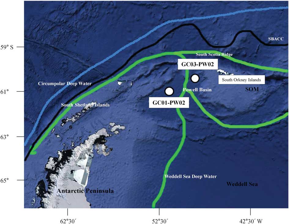
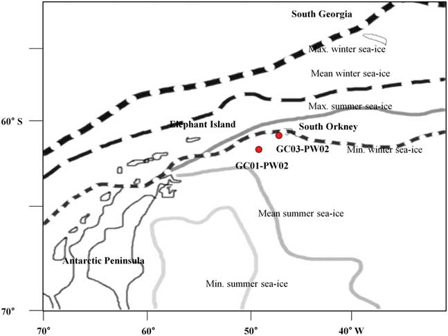
Powell Basin is in the north-west of the Weddell Sea, east of the Antarctic Peninsula and west of the South Orkney Islands (Fig. 1). Powell Basin was created by the eastward motion of the South Orkney microcontinent (SOM) relative to the Antarctic Peninsula (King & Barker Reference King and Barker1988). The SOM was incorporated into the Antarctic Peninsula during the Miocene as a consequence of the end of basin spreading (Rodriguez-Fernandez et al. Reference Rodriguez-Fernandez, Balanya, Galindo-Zaldivar and Maldonado1997). The Antarctic Peninsula is the main source of terrigenous sediments carried into Powell Basin (Pudsey Reference Pudsey1992).
Core locations map of the GC01-PW02 and GC03-PW02 core sediments in Antarctica (Google Earth, 2017). SOM: South Orkney Microcontinent, SBACC: Southern Boundary of the Antarctic Circumpolar Current.

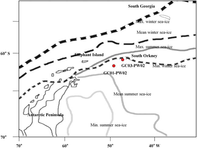
In the region of Powell Basin, Antarctic surface water (ASW) occurs to a depth of c. 200 m. It is very cold, low in salinity and rich in dissolved oxygen. Surface waters show strong seasonal fluctuations due to the formation of sea ice. Below the ASW is Circumpolar Deep Water (CDW), to a depth of c. 800 m. The occurrence of CDW, which is warmer and higher in salinity than the surface water, is significant because this water mass continuously delivers heat to the lower section of the Antarctic ice shelves (Dinniman & Klinck Reference Dinniman and Klinck2004). On the Antarctic continental shelves, CDW transport has an important biological influence. The upwelling of CDW brings nutrients into the euphotic zone and can increase primary productivity of diatoms (Prézelin et al. Reference Prézelin, Hofmann, Mengelt and Klinck2000, Dinniman et al. Reference Dinniman, Klinck and Smith2011). The sea-ice distribution map is taken from Gersonde & Zielinski (Reference Gersonde and Zielinski2000) (Fig. 2).
The schematic diagram of sea-ice distribution is according to Naval Oceanography Command Detachment (1985) and Gersonde & Zielinski (Reference Gersonde and Zielinski2000). Solid line: summer, dotted lines: winter minimum, maximum and mean.
Materials
Gravity cores GC01-PW02 and GC03-PW02 were collected from Powell Basin at 50°31’W, 61°32’S (3144 m below sea level, core length 800 cm) and 48°49’W, 60°14’S (2564 m below sea level, core length 780 cm). GC01-PW02 and GC03-PW02 both are affected by the Weddell Sea Deep Water. It is also the area where the sea-ice distribution changes in the glacial–interglacial period (Gersonde & Zielinski, Reference Gersonde and Zielinski2000). GC01-PW02 mainly consists of mud and sandy mud, with clay distributed in the intervals 20–80 cm, 210–310 cm and 575–625 cm. The interval from 420–480 cm was devoid of sediment. GC03-PW02 consists mostly of mud and sandy mud, with sand and silty mud in the interval from 151–205 cm.
Methods
A total of 38 and 43 samples were collected from cores GC01-PW02 and GC03-PW02 respectively, and the following process was used to extract diatom fossils (Bak & Lee Reference Bak and Lee2017).
The dry samples (2 g) were placed in a 500 ml beaker into which 25 ml of hydrogen peroxide (H2O2: 30%) and 25 ml hydrochloric acid (HCl: 10%) were added. These samples were heated to 100 °C to oxidize the organic material and dissolve the carbonates, and then allowed to stand for 24 h. After completion of the reaction, samples were washed three times with distilled water. The residue was transferred to a 60 ml bottle and diluted to 60 ml for analysis. Slides for quantitative analysis of diatoms were made using the random settling method of Scherer (Reference Scherer1994). All diatoms were counted up to a minimum of 200 specimens excluding the resting spores of Chaetoceros spp. Diatom counts were conducted mainly by using the 400X and 800X magnifications of a Nikon E400 microscope, and small individuals were observed at 1000X. We observed 400 fields of view in slides of the horizons with very few diatoms.
Results
Diatom assemblage zones of GC01-PW02
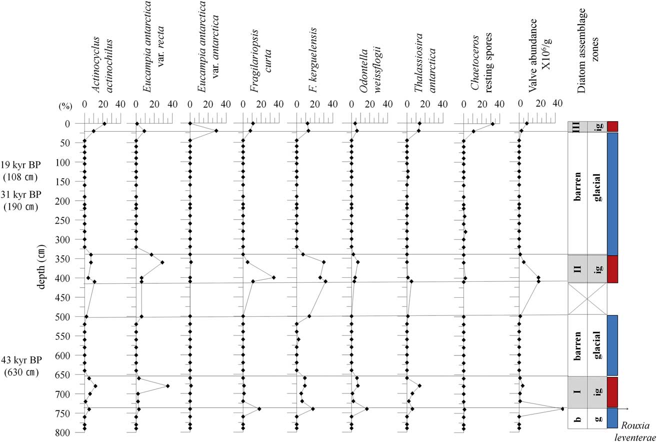
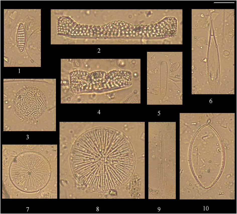
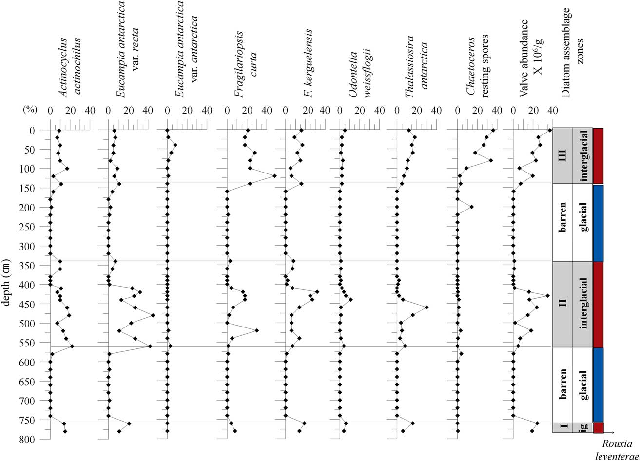
A total of 43 diatom species belonging 21 genera were identified from GC01-PW02 (Fig. 3). Absolute abundance in valves g-1 of dry sediment ranged from 0–48.3 × 10⁶ valves g-1. Valve abundance ranges widely, and the number of samples with diatoms is limited to three intervals within the core. Barren zones are defined as intervals with no diatoms, and occur from 45–320 cm, 520–640 cm and 760–790 cm. The dominant species in the diatomaceous intervals is Fragilariopsis kerguelensis (O’Meara) Hustedt (20%), followed by Eucampia antarctica (Castracane) Mangin var. antarctica (13%), Actinocyclus actinochilus (Ehrenberg) Simonsen (10.1%), Fragilariopsis curta (Van Heurck) Hustedt (9.7%), and Odontella weissflogii (Grunow) Grunow (6.4%) (Plate 1). Chaetoceros resting spores are observed only in the uppermost horizon (0–20 cm).
Downcore variations of relative abundance of the characteristic species and diatom assemblage zones from GC01-PW02. b: barren, Ig: interglacial, g: glacial.
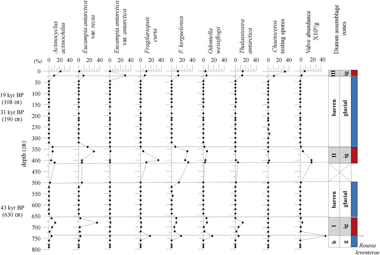
Plate 1. 1. Fragilariopsis kerguelensis (O’Meara) Hustedt, GC01-PW02 20 cm, 2. Eucampia antarctica var. recta (Mangin) stat. nov., GC01-PW02 360 cm, 3. Thalassiosira antarctica Comber, GC01-PW02 1 cm, 4. Eucampia antarctica (Castracane) Mangin var. antarctica, GC01-PW02 20 cm, 5. Fragilariopsis curta (Van Heurck) Hustedt, GC03-PW02 120 cm, 6. Rhizosolenia styliformis Brightwell, GC03-PW02 520 cm, 7. Actinocyclus actinochilus (Ehrenberg) Simonsen, GC03-PW02 480 cm, 8. Actinocyclus octonarius Ehrenberg, GC01-PW02 1 cm, 9. Rouxia leventerae Bohaty et al., GC03-PW02 780 cm, 10. Odontella weissflogii (Grunow) Grunow, GC03-PW02 440 cm. Bar scale: 10 μm.
Based on diatom abundances and assemblages, three barren and three assemblage zones were identified. Absolute diatom abundance and relative species abundances are plotted in Fig. 3.
Diatom assemblage zone I (740–660 cm): absolute diatom abundance ranges between 0.9 × 10⁶ and 48.3 × 10⁶ valves g-1, and reaches a maximum at 740 cm. Eucampia antarctica var. recta (Mangin) stat. nov. peaks at 680 cm. The open water species F. kerguelensis, and O. weissflogii and Thalassiosira antarctica Comber warm type are also common.
Diatom assemblage zone II (500–340 cm): diatom abundances range from 1.2–21.6 × 10⁶ valves g-1. A. actinochilus and E. antarctica var. recta are most abundant between 340 cm and 410 cm. The sea-ice species F. curta reaches a maximum at 400 cm. The open water species F. kerguelensis and O. weissflogii occur throughout this interval.
Diatom assemblage zone III (20–1 cm): diatom abundance is highest in the uppermost sediment. Eucampia antarctica var. antarctica and Thalassiosira antarctica warm type occur at 20 cm, while Actinocyclus actinochilus, Thalassiosira antarctica cold type, and Chaetoceros resting spores dominate the uppermost sample at 1 cm.
Diatom assemblage zones of GC03-PW02
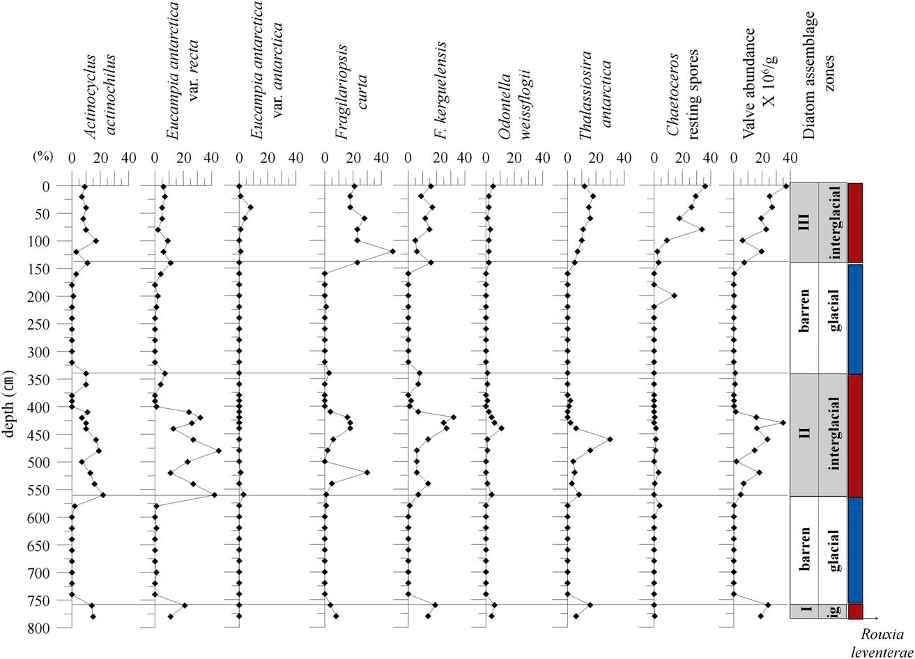
In total, 61 diatom species belonging 27 genera were identified from GC03-PW02. Diatom abundance ranges from 0.1–37 × 106 valves g-1. The dominant species was E. antarctica var. recta (17.6%), followed by F. curta (14.9%), F. kerguelensis (13.7%), A. actinochilus (12.3%), and the warm type of T. antarctica (5.5%). Chaetoceros resting spores are abundant from 2–100 cm. A total of five diatom assemblage zones were established for GC03-PW02, based on the vertical distribution of selected species (Fig. 4).
Downcore variations of relative abundance of the characteristic species and diatom assemblage zones from GC03-PW02. Ig: interglacial.
Barren zones (740–580 cm, 320–160 cm): these intervals are characterized by low abundances, ranging from 0–0.4 × 10⁶ valves g-1.
Diatom assemblage zone I (780–760 cm): diatom abundances range between 19 × 106 and 24.3 × 10⁶ valves g-1. In this zone, the ice edge species A. actinochilus and E. antarctica var. recta are abundant, as are the open water species F. kerguelensis and O. weissflogii.
Diatom assemblage zone II (560–340 cm): diatom abundances range between 0.2 × 10⁶ and 4.8 × 10⁶ valves g-1. The ice edge species A. actinochilus and E. antarctica var. recta and the sea-ice species F. curta are abundant from 560–420 cm. The open water species F. kerguelensis and Odontella weissflogii are most abundant from 460–420 cm, and Thalassiosira antarctica warm type peaks from 480–460 cm.
Diatom assemblage zone III (140–2 cm): Diatom abundance range from 6.3–37 × 106 valves g-1, and increases upcore. Eucampia antarctica var. recta abundances are low as compared to abundances in zone I and II. In contrast, E. antarctica var. antarctica is observed between 40 and 60 cm. The sea-ice species F. curta is more abundant than observed in diatom assemblage zone II, and Thalassiosira antarctica cold type is also abundant. In addition, F. kerguelensis, Odontella weissflogii and Thalassiosira antarctica warm type are consistently present. Chaetoceros resting spores are the most abundant diatom group observed, peaking in the surface-most sediments.
Discussion
Age
Two approaches were utilized to develop chronologies for these cores, radiocarbon dating, in GC01- PW02 only, and a diatom biostratigraphic marker, specifically the occurrence of Rouxia leventerae, which is a marker for the MIS6/5 boundary, with its last occurrence 0.13–0.14 Ma (Zielinski et al. Reference Zielinski, Bianchi, Gersonde and Kunz-Pirrung2002, Cody et al. Reference Cody, Levy, Harwood and Sadler2008). The use of diatom biomarkers is especially useful for Southern Ocean sediments in which calcareous microfossils can be very rare.
Accelerator mass spectrometry (AMS) 14C dates were acquired for three samples in GC01-PW02, all completed on the planktonic foraminifera Neogloboquadrina pachyderma (Ehrenberg) (sinistral coiling). Three dates were based on samples with the diatom barren glacial zones. Low abundances of N. pachyderma (s.) are found in the water under permanent ice in the Antarctic and Arctic (Carstens & Wefer Reference Carstens and Wefer1992). However, N. pachyderma (s.) is also in high abundance in some Antarctic sea-ice samples (Spindler & Dieckmann Reference Spindler and Dieckmann1986). The uncorrected radiocarbon ages increase downcore from 19 kyr bp at 108 cm, to 31 kyr at 190 cm and 43 kyr at 630 cm.
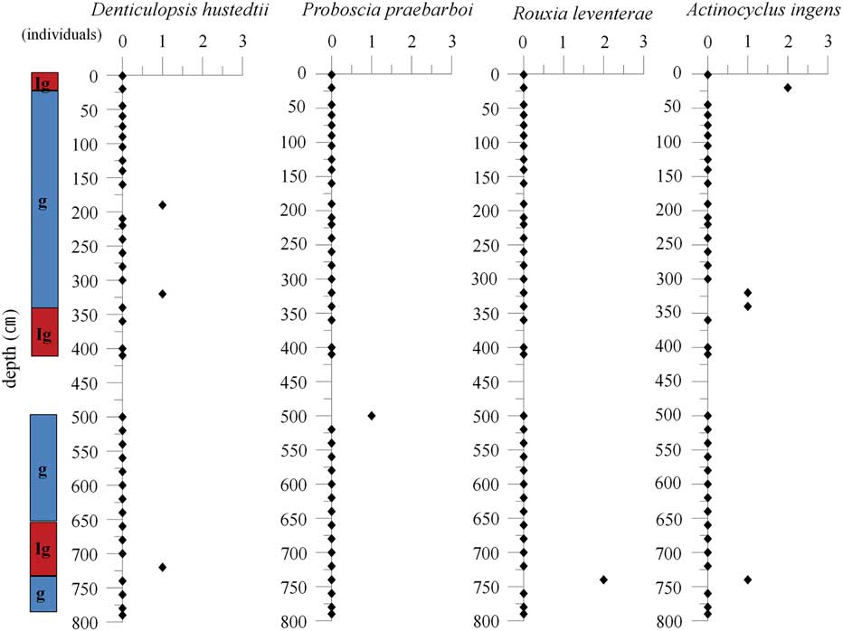
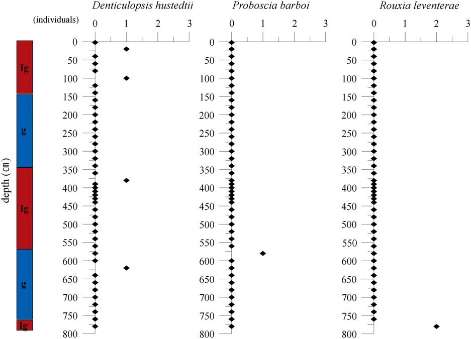
Rouxia leventerae was observed only at 740 cm in GC01-PW02, and at 780 cm in GC03-PW02 (Figs 3 & 4). The total number of R. leventerae was very low, and complete specimens were not observed. In the case of GC01-PW02, the presence of R. leventerae occurs at the boundary between the lowermost barren unit and the overlying interglacial; the data suggest this is the MIS6/5 boundary and that the overlying sediments were deposited after 0.13 Ma. In GC03-PW02, the observation of this species in the lowermost sample may reflect that the core penetrated just barely into MIS 6, and that as in GC01-PW02, overlying sediments were deposited after 0.13 Ma.
Palaeontological interpretation
One of the primary goals of this work was to provide a chronological and palaeoenvironmental context for the alternating diatom-abundant versus diatom-poor sediments recovered in two gravity cores from Powell Basin. Given the role of sea-ice cover in restricting light penetration and hence primary productivity, these sediments are interpreted to reflect interglacial and glacial conditions respectively. The record in these two cores provides evidence for expanded sea-ice extent during glacial periods such that diatom production was severely limited. In the Bransfield Strait during interglacial periods, particle flux peaks occur with open water conditions and the vertical flux of siliceous organisms from surface waters is extremely low under ice cover (Abelman & Gersonde Reference Garrison1991). Across both cores, three presumed interglacial intervals were recovered. In GC01-PW02, two glacial intervals were recovered, while in GC03-PW02, three glacial intervals were recovered.
This study has established six and five diatom zones from the cores GC01-PW02 and GC03-PW02 respectively. At the same time, these cores also contain two and three barren zones that almost completely lacked diatoms; these zones correspond to glacial periods during which the research area was covered with sea ice, and so had almost no diatoms as well as poor preservation.
The interglacial intervals were identified by the presence of abundant diatoms, with assemblages that are typical of the Southern Ocean (Armand et al. Reference Armand, Crosta, Romero and Pichon2005, Crosta et al. Reference Crosta, Romero, Armand and Pichon2005) and reflect an environment with seasonal sea-ice cover. Species present include those associated with sea ice and the marginal ice zone, such as F. curta (Scott et al. Reference Scott, McMinn and Hosie1994, Leventer & Dunbar Reference Leventer and Dunbar1996), A. actinochilus (Gersonde Reference Gersonde1984, Horner Reference Horner1985, Tanimura et al. Reference Tanimura, Fukuchi, Watanabe and Moriwaki1990, Garrison Reference Garrison1991), and those associated with more open Southern Ocean waters, including F. kerguelensis (Crosta et al. Reference Crosta, Romero, Armand and Pichon2005).
Interestingly, Chaetoceros resting spores are only abundant within the uppermost interglacial unit, zone III, and in both cores its abundance increases upward within this unit. In addition, Eucampia antarctica var. antarctica, is also present in higher abundances in the youngest interglacial. These data suggest that this zone may reflect the most productive time period recovered by these cores.
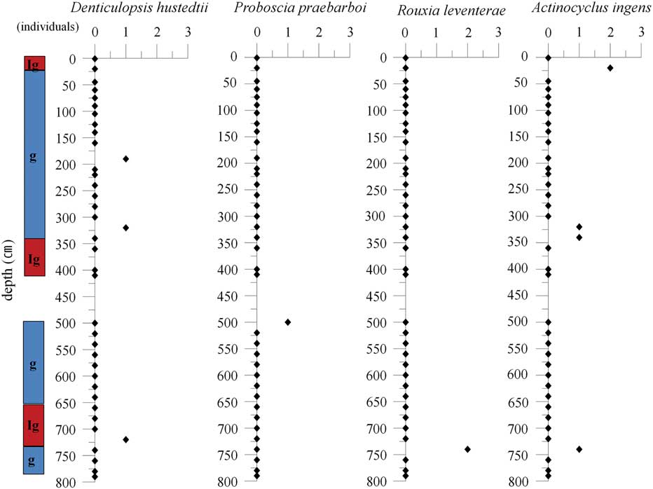
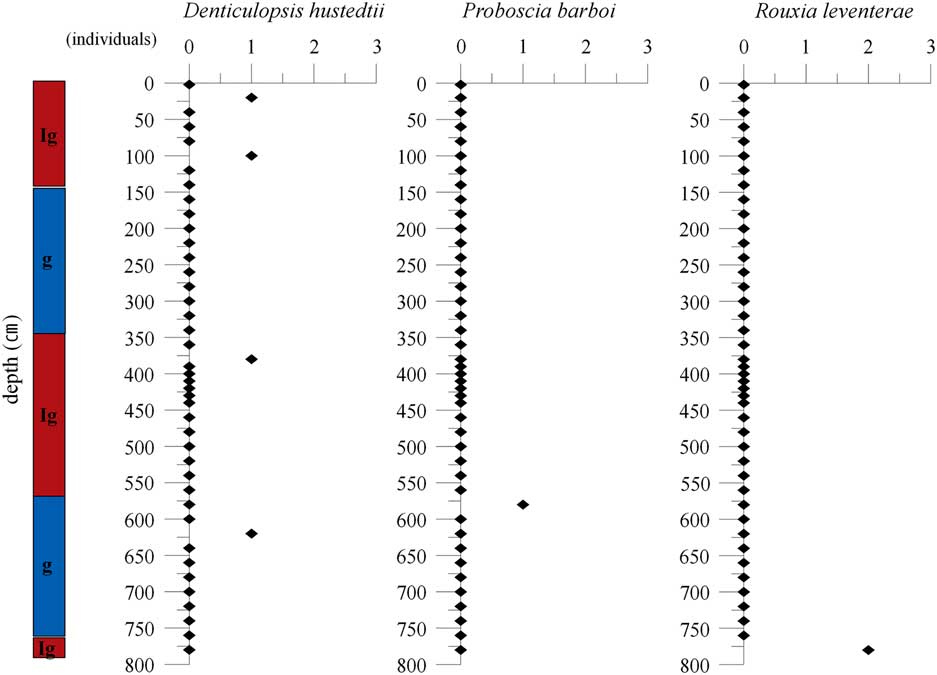
Reworked species were also observed, though in very low abundances. Species observed include Actinocyclus ingens Rattray, Denticulopsis hustedtii (Simonsen & Kanaya) Simonsen, Proboscia barboi (Brün) Jordan & Priddle 1991, and Proboscia praebarboi (Schrader) Jordan & Priddle 1991 (Figs 5 & 6).
Distribution of reworked species and age index (GC01-PW02). Ig: interglacial, g: glacial.
Distribution of reworked species and age index (GC03-PW02). Ig: interglacial, g: glacial.
These reworked species may have been transported by the ice-rafted debris during the summer season of the interglacial periods.
Also, Powell Basin is influenced by a strong bottom current, which causes reworked species to be transported.
Conclusions
A total of 43 species of 21 genera and 61 species of 27 genera of diatoms were identified from two cores, GC01-PW02 and GC03-PW02, collected near Powell Basin. Based on diatom abundance and assemblage data, this study established six diatom assemblage zones in GC01-PW02, comprised of alternating glacial (barren zones) and interglacial (diatom assemblage zones). These changes are directly related to changes in palaeoclimate. GC03-PW02 is defined to five diatom assemblage zones; three zones with abundant diatoms (interglacials), alternate with two barren zones (glacials). Core chronologies based on limited radiocarbon dating and a key diatom biostratigraphic indicator, R. leventerae, for the MIS 6 / MIS 5 boundary provide support for the interpretation that these cores contain sediments deposited since MIS 6.
Acknowledgements
This research was supported by Basic Science Research Program through the National Research Foundation of Korea (NRF) funded by the Ministry of Education (NRF-2018R1D1A1B07048767), and funded by KOPRI Grant PE18030. We thank the two anonymous reviewers for critical comments of the manuscript.
Author contributions
Lee and Yoon led the project planning and field activities. Bak carried out the comprehensive analysis and microscopic observation of the diatoms. Yoo analysed the results from sedimentological data. All authors contributed to the discussion of the results and to writing the manuscript.