

1. introduction
In light of the urgent need for coastal adaptation policies and the impediments to their implementation, this article examines the early experience with coastal adaptation in the European Union (EU) and Australia, and identifies the important features that effective regulatory frameworks for coastal adaptation should possess. Our focus is on regulation because research on coastal adaptation law indicates that the judiciary has neither the jurisdiction nor the capacity to respond proactively or systematically to new policy challenges: while judicial decisions can drive policy change, they can only ever respond to specific disputes and the outcome of such cases binds only those parties to the dispute.Footnote 1 Furthermore, while voluntary or autonomous adaptation may be appropriate in some cases, the interconnectedness of coastal and other impacts demands a planned response in order to minimize adverse impacts arising from the implementation of particular policies.
The identification of the essential features of an effective coastal adaptation regulatory regime draws on a comparison between experiences with coastal adaptation in the EU, in particular in the Netherlands and the United Kingdom (UK),Footnote 2 and in Australia. The Netherlands and Australia each have a heavily populated coastline, and England, especially the greater London area, is vulnerable to the consequences of sea level rise. All three countries initiated early coastal adaptation policies,Footnote 3 but these policies have differed markedly in approach. In 2011, the Netherlands redesigned large parts of its existing laws and adopted new legislation specifically aimed at increased coastal adaptation efforts as a result of climate change. These measures responded to both the deeply rooted memory of the 1953 inundation of the south western coast that killed 1,835 people, and the 1995 high water event during which 250,000 people had to be evacuated from their homes and extensive floods were only just prevented.Footnote 4
The new laws partly follow EU directives in the field of water and marine law, so an examination of the Dutch reforms also serves as a lens through which to consider the EU’s approach to coastal adaptation. In contrast to the Netherlands’ heavily centralized strategy for coastal adaptation, recent reforms in the UK adopt comprehensive coastal adaptation policies using a more localized approach. In Australia, to date, adaptation policies have tended to lack legislative authority, preferring policy statements and planning instruments. Courts have had to deal with an increasing number of cases involving coastal erosion and local authority action or inaction in response to that erosion.Footnote 5 Although this legislative inertia has been heavily criticized by some Australian scholars,Footnote 6 the evolving practices of planning courts and tribunals do bring to light further elements for the model regulatory framework that is the goal of our study.
The remainder of this article is organized as follows: Section 2 briefly introduces the impact of climate change on coasts and coastal adaptation. Section 3 outlines the current international and regional frameworks for adaptation in general and coastal adaptation in particular, including the United Nations (UN) Framework Convention on Climate Change (UNFCCC)Footnote 7 and EU law. Section 4 sets out the policy, legislative and judicial responses to coastal adaptation in the Netherlands, the UK and Australia. Elements of the international and domestic frameworks that are considered essential for effective adaptation are identified and discussed in Section 5, and Section 6 presents our conclusions.
2. the impact of climate change on coasts and coastal adaptation
Responses to the impact of climate change on coastal areas are among the most debated elements of adaptation policy and law. This is not surprising, given the expected effects of climate change on coasts and coastal populations. The Intergovernmental Panel on Climate Change (IPCC) projects an accelerated sea level rise of up to 0.6 metres by 2100, or more if the potential breakdown of the West Antarctica and Greenland ice sheets is taken into account, with levels continuing to rise for many centuries beyond 2100.Footnote 8 Storms can temporarily exacerbate higher water levels, by 20 to 110 centimetres,Footnote 9 and increasing storm intensity and larger storm surges as a result of climate change can combine with rising sea levels to cause more coastal erosion and inundation of low-lying areas.
The situation is further aggravated in some parts of the world by a range of local factors, such as soil subsidence. In north-western Europe, subsidence is a legacy of the last glacial period which ended 10,000 years ago. For example, by 2100, the Dutch coast is projected to have experienced local soil subsidence of 1.0 metre at today’s level.Footnote 10 The combined effect of sea level rise, storm surge and subsidence in the Netherlands is projected to be equivalent to a relative sea level rise of over 1.3 metres by 2100 and 2 to 4 metres by 2200.Footnote 11
Close to one quarter of the world’s population lives within a 100 kilometre zone from the coast.Footnote 12 The coastal population is projected to grow from 1.2 billion people in 1990 to 1.8 or even 5.2 billion people by the 2080s, depending on assumptions about migration.Footnote 13 The value of the economic assets within 500 metres from the European coastline alone is estimated to be €500–1,000 billion. Over one third (€3.5 trillion) of the total gross domestic product (GDP) of the 22 coastal Member States of the EU is generated within 50 kilometres from the coast.Footnote 14 Many of these areas are already just above or even below the current sea level and are protected from the sea by man-made sea defences. In Europe, the North Sea region, in particular, depends heavily on coastal defence works.Footnote 15 Some of these have been in place for centuries and most are vulnerable to the impacts of climate change.Footnote 16 European cities such as London (UK) and Rotterdam (the Netherlands), as well as major Asian coastal cities such as Tokyo (Japan) and Shanghai (China), depend almost entirely on engineered coastal fortification for protection against coastal processes.Footnote 17
Many densely populated coastal areas are estuaries or deltas. The majority of the largest cities in the world are located on estuaries, and include New York City (US), Sydney (Australia), Calcutta (India), Hong Kong (China), Shanghai (China) and Buenos Aires (Argentina).Footnote 18 Not only do these areas face sea level rise, but they are also confronted with altered precipitation and run-off as a result of climate change,Footnote 19 which may lead to freshwater estuarine flooding. Most deltas are also undergoing soil subsidence that results in accelerated rates of relative sea level rise above the global average.Footnote 20 The combination of all of these factors (high river water levels, a storm at sea and increased relative sea level) makes deltas particularly vulnerable to the impacts of climate change.
In light of these projected impacts, the IPCC concludes that effective adaptation is urgently required, and argues that adaptation and disaster response measures should be integrated into coastal management plans.Footnote 21 The IPCC defines adaptation as ‘the adjustment of natural or human systems in response to actual or expected climatic stimuli or their effects, which moderates harm or exploits beneficial opportunities’.Footnote 22
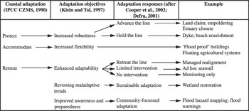
The IPPC recognizes that adaptation can be anticipatory or reactive, planned or autonomous, public or private,Footnote 23 and categorizes coastal adaptation objectives and responses as shown in Figure 1, according to the objectives of protection, accommodation or retreat. Figure 1 shows the variety of responses and measures that can be taken as part of a coastal adaptation policy.
Evolution of planned coastal adaptation practicesFootnote 24

In many places, some options will be technically impossible or economically unviable. Even where technical solutions are feasible, all of these measures face institutional and legal challenges because of different views of the stakeholders involved in coastal development issues.Footnote 25 Societal opposition to adaptation measures varies enormously as a result of individual community preferences, priorities and values, as well as the different costs, impacts and implications of each option.Footnote 26 Opposition may focus on seawalls because of the associated destruction of existing coastal ecosystems. Wetland restoration and floodplain creation may also face opposition because of the perceived increase in flood risks when existing fixed structures are replaced by more natural flood defences.Footnote 27 In Australia, coastal property owners have already challenged adaptation policies aimed at coastal retreat,Footnote 28 and there is public debate over those aimed at building seawalls.Footnote 29
In addition to the technical, financial and political constraints on coastal adaptation options, fragmented and ineffective institutional arrangements and weak governance constitute important barriers to developing and implementing coastal adaptation policies.Footnote 30 In many places, it is difficult, if not impossible, to garner the cooperation of all landowners, local and regional authorities so as to develop coherent new or improved coastal defences.
3. the international and european legal frameworks for coastal adaptation
3.1. The International Framework
Both the UNFCCC and its Kyoto ProtocolFootnote 31 contain provisions relating to adaptation. Article 4(1) of the UNFCCC lists the adaptation commitments of the Parties, including implementing national and regional programmes, integrating adaptation measures in the relevant social, economic and environmental policies and actions, promoting and cooperating in research, exchanging information, and promoting and cooperating in education, training and public awareness. Article 4(1)(e) provides that Parties to the UNFCCC shall:
cooperate in preparing for adaptation to the impacts of climate change; develop and elaborate appropriate and integrated plans for coastal zone management, water resources and agriculture, and for the protection and rehabilitation of areas, particularly in Africa, affected by drought and desertification, as well as floods.
Article 4(8) obliges all Parties to focus on the specific needs and concerns of developing country Parties arising from the adverse effects of climate change and the impact of the implementation of response measures. Small island countries and countries with low-lying coastal areas – that is, countries that are especially vulnerable to sea level rise – are mentioned particularly here. The Adaptation FundFootnote 32 was established in 2001 under the Kyoto Protocol to provide financial assistance to such countries.Footnote 33 Its aim is to finance concrete adaptation projects in developing country Parties to the Kyoto Protocol. The first adaptation project – in respect of coastal erosion caused by sea level rise in SenegalFootnote 34 – was funded in 2010, almost ten years after the decision was taken to establish an adaptation fund. Also within the other funds, such as the Least Developed Countries FundFootnote 35 and the Special Climate Change Fund,Footnote 36 special attention is given to funding adaptation. There is a growing recognition of the need for enhanced international frameworks for adaptation, particularly to assist developing countries: the 2009 Copenhagen Accord and the 2010 Cancún Conference of the Parties (COP) both addressed the importance of adaptation financing, and identified the need for institutional and technical infrastructure to support adaptation efforts;Footnote 37 this resulted in the establishment of the Green Climate Fund to channel new and existing financial resources.Footnote 38
Within other international legal frameworks, there is growing attention to coastal adaptation. Coastal and riverine wetlands are considered to be important in any coastal adaptation policy because they offer natural sea defences (mangroves, dunes and others) or can be used as natural floodplains or water storage areas in high-water situations.Footnote 39 In 2002, the COP of the Convention on Wetlands of International Importance Especially as Waterfowl Habitat (Ramsar Convention)Footnote 40 adopted a resolution on adaptation to climate change and wetlands, in which the Parties are called upon to reduce the risk of flooding and drought by promoting wetland and watershed protection and restoration.Footnote 41 Under the Convention on Biological Diversity (CBD),Footnote 42 an Ad Hoc Technical Expert Group on Biodiversity and Climate Change has been looking at the broad relationship between climate change and biodiversity. In 2010, the Parties to this Convention repeatedly stressed the need to integrate marine and coastal biodiversity policies with climate related policies.Footnote 43
Since 2008, attention has also been paid to coastal adaptation measures under the Convention for the Protection of the Marine Environment of the North-East Atlantic (OSPAR Convention).Footnote 44 In a 2009 Report,Footnote 45 the OSPAR Commission reviewed the national adaptation policies of its Member States and urged its members to integrate adaptation measures into Integrated Coastal Zone Management (ICZM) and marine spatial planning, as facilitated by both the OSPAR Convention, the EU Marine Strategy Framework Directive (MSFD)Footnote 46 and Water Framework Directive (WFD).Footnote 47 The Report specifically mentions Dutch and UK examples of coastal adaptation measures and policies, detailed in Section 4 below. In addition, coastal adaptation is one of the key issues integrated in the North-East Atlantic Environmental Strategy, adopted at the 2010 OSPAR ministerial conference.Footnote 48 Also in 2010, the UN General Assembly encouraged states to develop means of marine and coastal adaptation under the UN Convention on the Law of the Sea (UNCLOS)Footnote 49 and other relevant international frameworks.Footnote 50 The UNCLOS secretariat itself produced a general document on oceans and climate change, in which some attention is paid to adaptation by stating that the resilience of coastal ecosystems such as mangroves, salt marshes and sea grasses should be enhanced, that integrated conservation and management measures to protect marine species should be adopted and that the vulnerability of coastal communities, particularly in developing countries, should be reduced by capacity-building and the transfer of technology.Footnote 51
There are other examples of multilateral organizations in which similar developments are taking place, especially those dealing with regional river basins or regional seas,Footnote 52 but it is fair to say that the legal impact of these efforts so far is relatively low, with the exception of efforts being undertaken in the EU.
3.2. The European Union Framework
As is the case at the international level, the EU’s adaptation policy is generally not well developed because of the EU’s focus on climate change mitigation. The EU, however, has adopted binding legislation forcing its Member States to develop coastal and estuarine adaptation law. These requirements stem from the EU 2000 Water Framework Directive (WFD),Footnote 53 the 2007 Floods Directive,Footnote 54 the 2008 Marine Strategy Framework Directive (MSFD),Footnote 55 as well as a series of non-legally binding policy documents in which Member States are urged to incorporate adaptation in their coastal management.Footnote 56
The WFD provides a holistic legal framework for all water issues – that is, water quality and water quantity issues, in respect of both surface and ground waters, as well as coastal waters. It sets the institutional framework through river basin districts, river basin management plans and programmes of measures. Only the Floods Directive was explicitly adopted to address increased inland and coastal floods caused by climate change. The Floods Directive largely uses the institutional framework offered by the WFD, although it also allows for separate authorities to be appointed to address coastal floods.Footnote 57
The Floods Directive advises Member States to integrate flood mitigation measures into river basin management plans and programmes of measures.Footnote 58 It introduces three steps that are to be taken to address increasing flood risks. First, a Preliminary Flood Risk Assessment (PFRA) must be carried out for each river basin district, based on past floods, but also taking into account long-term developments as a consequence of climate change.Footnote 59 The assessment must include maps of areas that are prone to flooding, as well as an assessment of the potential adverse consequences for human health, the environment, cultural heritage and economic activity.Footnote 60 All assessments were to have been completed by December 2011.
The second step is to draft Flood Hazard Maps and Flood Risk Maps.Footnote 61 Flood Hazard Maps cover potentially flooded areas according to various scenarios (low–high probability, extreme events). For each scenario, Flood Hazard Maps must indicate the flood extent, water depths or water levels, and the flow velocity. Flood Risk Maps show the potential negative consequences for each of the scenarios – the number of people, the type of economic activity and the industrial installations affected (as a result of pollution that may spread as a consequence of flooding), and the areas where sediments, debris or pollution might end up. Both sets of maps are to be completed by December 2013. Based on the PFRA and the maps, the third step involves the adoption of Flood Risk Management Plans, based on the ‘three Ps’: prevention, protection, preparedness.Footnote 62 Plans must include measures that lead to a reduction in the negative consequences of flooding and in the likelihood of flooding through such instruments as flood conveyance routes, flood water retention areas and areas of controlled flooding. These measures may be implemented through reforms to land use planning, nature conservation and port infrastructure laws and requirements. Measures must not simply shift flood risks upstream or downstream. Flood forecasts and other early warning systems must also be set up.Footnote 63 Flood Risk Management Plans are to be completed by December 2015. All of these instruments must be updated every six years.Footnote 64 The Floods Directive may become integrated into a wider climate change disaster management policy which is currently being developed at the EU level.Footnote 65
Like the Floods Directive, the MSFD explicitly refers to climate change, but with less focus on adaptation. The Directive makes clear that integrated coastal zone management is the prime instrument for coastal adaptation and should be developed within the EU using the MSFD’s instruments, which include the marine strategy and an associated programme of measures aimed at achieving improvements in the environmental status of marine and coastal waters.Footnote 66 The MSFD does not refer to flooding or to the Floods Directive. This compartmentalization is a major shortcoming since the Floods Directive addresses both inland and coastal flooding and an integrated set of measures dealing with freshwater and saltwater flooding should be incorporated into integrated coastal zone management.
The discussion in this section highlights the limited scope of international legal instruments dealing specifically with coastal adaptation. The EU directives on water, flood and marine conservation provide more specific guidance for Member States, but even these lack coordinated and coherent requirements for coastal adaptation strategies per se. The next section examines how these requirements have been operationalized in two EU Member States and the approach taken by a non-EU state.
4. current domestic legal frameworks for coastal adaptation measures in the netherlands, the uk and australia
4.1. The Netherlands
Nearly 9 million people live in low-lying parts of the Netherlands and about 65 per cent of GDP is generated in those parts of the country.Footnote 67 Much of this land consists of drained marshes and lakes or land reclaimed from the sea. For a thousand years or so, artificial dikes have been in place to protect areas that are below mean sea level against flooding by the sea and rivers. Without the protection of dikes, dunes and hydraulic structures (such as storm surge barriers) approximately 60 per cent of the country would be flooded regularly.Footnote 68 Most of the land on the coastline, particularly the sand dunes and the dikes, is owned by the state. This makes implementation of coastal adaptation measures easier than in cases where coastal property is privately owned.
This history of land reclamation means that for centuries laws have been in place aimed at stringent dune building and management, and maintaining rigid sea defence structures.Footnote 69 Since the 1990s, regulation has required that the coastline is to be maintained at its 1990 position, irrespective of future sea level and other conditions.Footnote 70 This approach has been criticized for not offering the optimal response to climate change, with critics instead preferring measures that work with coastal dynamics and enhancing natural processes to provide a more resilient coastline in the long run.Footnote 71 This new acceptance of coastal processes is slowly entering Dutch coastal adaptation policy and law.
The Netherlands has taken a holistic approach to all water issues, in line with the EU’s WFD. The Dutch Water Act 2009 and the accompanying Water Ordinance 2009 cover all water law, including rules on the prevention of flooding and the development of a marine strategy.Footnote 72 The Act and Ordinance implement all the EU water, floods and marine conservation strategy directives.Footnote 73 Water policy in general has been decentralized to water boards (based on regional weirs) and provincial authorities, but responsibility for the main dikes and embankments along the coast and along the major rivers rests with the Minister of Infrastructure and the Environment and the national water management agency (Rijkswaterstaat).Footnote 74 The Minister is required to cooperate with the other authorities involved, but has far-reaching powers to either force cooperation or overrule other authorities if necessary.Footnote 75
The National Water Plan 2009–15 articulates the nation’s overarching water policies and incorporates the four river basin management plans as required under the WFD.Footnote 76 The National Water Plan is the policy framework for three programmes relevant to coastal adaptation: the National Flood Defence Construction Programme, the Sand Nourishment Programme and the Room for the River programme. Under the National Flood Defence Construction Programme, the primary weirs – those that are in direct contact with sea water – are reviewed every five years, taking into consideration climate change scenarios for the Dutch coast. Those weirs that fail to meet the required standards must be reinforced immediately. In a dedicated programme, special attention is given to priority ‘weak links’ that have been identified along the coast. These links are currently being strengthened so that they can withstand a 1:4,000-year-storm by 2015.Footnote 77
The Plan’s main response to sea level rise is to promote large-scale beach nourishment along the entire Dutch coast in a manner that disturbs natural processes as little as possible and on a scale necessary to keep pace with the actual sea level rise.Footnote 78 Under the Sand Nourishment Programme, sand nourishment takes place along the Dutch coast to replenish eroded beaches. An innovative experimental sand nourishment project is proposed. The so called ‘sand engine’ project involves the dredging and positioning of a super dune of sand in the sea in such a way and in a location that enables hydrological forces to spread the sand to where it is needed. If the experiment is successful, the sand engine will replace regular artificial sand nourishment.Footnote 79
Under the Room for the River programme, land use plans designate water storage areas to be used for controlled flooding, and natural floodplains are expanded using a combination of land use controls and compulsory acquisition.Footnote 80 These natural floodplains were developed to deal with high water levels in the river and simultaneously to create additional wetlands under nature conservation laws.Footnote 81 Most of these policies are implemented under the Water Act, but some are undertaken pursuant to the Spatial Planning Act.Footnote 82
The Water Act contains safety norms for dikes and embankments, which are based on probability rates varying between 1:250 and 1:10,000 that critical water levels might be reached in any given year, depending on the number of people and the infrastructure protected by the dike.Footnote 83 The specific requirements for dikes and embankments in terms of height and strength are derived from that norm. These norms are currently subject to debate as they are considered to take insufficient account of sea level rise and increased storm intensity.Footnote 84 A 0.7 metre sea level rise increases the flood risk by a factor 10, and if we include the expected soil subsidence by 2100 of 1.0 metre, plus an additional 0.5 metre rise in sea level during storms, the risk increases dramatically.Footnote 85 Therefore, in 2008, an advisory commission advised the Dutch government to increase the safety norms by at least a factor of 10 by 2013 (up to a factor of 100 for some areas), and to implement these increased safety norms before 2050.Footnote 86 It is expected that the government will present its plans to implement this recommendation by 2012–13.
The Water Act contains a range of provisions aimed at protecting land against flooding; these include:
• procedural provisions on decisions to create or change coastal or river defence works;Footnote 87
• the conferral on the Minister of power to take all necessary measures in the event of danger.Footnote 88 A danger is defined as ‘circumstances as a consequence of which water management works are under an immediate and serious threat or can become under such a threat’.Footnote 89 The Minister is even allowed to take measures that are contra legem, as long as they do not infringe the constitution, EU or international law;Footnote 90
• the obligation to organize exercises to deal with dangerous situations;Footnote 91
• the duty on property owners to allow authorized officers to enter or perform works in any place that they deem necessary, and the power of authorized officers to enter a property without the owner’s consent;Footnote 92
• the duty on property owners in water storage areas to allow their land and other property to be flooded;Footnote 93
• a prohibition on property owners in a water storage area to build anything that is considered to be an obstacle for water storage;Footnote 94
• the possibility for property owners in water storage areas to claim compensation in respect of loss or damage suffered as a result of flooding or restrictions on land use;Footnote 95
• compulsory acquisition of land where this is necessary for dike and embankment works;Footnote 96 and
• a prohibition on interference with coastal and river defence works without a permit.Footnote 97
In 2011, three important amendments were made to the Water Act 2009 in order to complete the regulatory framework for coastal adaptation.Footnote 98 These amendments establish a Delta Programme, a Delta Programme Commissioner to oversee implementation of the Programme,Footnote 99 and a Delta Fund. The Delta Programme is a new annual plan with a six-year planning horizon detailing all measures necessary to combat floods and water scarcity as a consequence of climate change. The Delta Fund will provide the resources required to implement the Delta Programme. The Act stipulates that, as of 2020, €1 billion is to be made available annually under the Fund.
The regulatory instruments of the Spatial Planning Act are used to avoid unwanted land use developments taking place. The national Spatial Planning Key Decision to implement the Room for the River programme, for instance, states that a land reservation applies where land will or can be given to the river by setting the dike further back from it. This means that:
• land needed for measures in the basic package will be safeguarded from developments which might stand in the way of a flood defence installation; and
• land where measures are expected to be needed in the long term will be safeguarded against large-scale and/or capital-intensive developments which will seriously impede future river relief measures from being taken.Footnote 100
Provincial and local zoning plans have to be adjusted to accommodate the implementation of the national Spatial Planning Key Decision.
It can be concluded that the Netherlands has a comprehensive regulatory system in place that seems well suited to address the challenges imposed on its coasts by climate change, provided that the funds that have to be made available will indeed be allocated on time. The regulatory system relies on the cooperation of all decentralized authorities involved, but with firm supervision by the competent minister at the central level.
4.2. The United Kingdom
Like the Netherlands, the UK has adopted new integrated water legislation: the Flood and Water Management Act 2010 (FWMA 2010).Footnote 101 The Act is more specific in its focus on coastal adaptation than its Dutch equivalents, as its main objective is ‘to make provision about water, including provision about the management of risks in connection with flooding and coastal erosion’.Footnote 102 Unlike the Netherlands’ more centralized approach to water governance, implementation of the FWMA 2010 rests principally with lead local flood authorities (LLFA) – newly designated local authorities that are typically established at the county level. Each LLFA must develop, maintain, apply and monitor a local flood risk management strategy for its local area and direct and coordinate other local authorities in the area in its implementation.Footnote 103 The measures that can be taken to reduce flood risks are very wide and include such measures as erecting flood defence structures, removing buildings, restoring natural processes, reducing or increasing the level of water in a place, supporting or diverting river banks, carrying out shoreline protection, and a range of other statutory prohibitions, restrictions and powers.Footnote 104
While implementation is occurring at the local level, there is a great deal of coordination taking place at the national level, particularly by the UK Environment Agency.Footnote 105 The Environment Agency, through its Regional Flood and Coastal Committees,Footnote 106 must develop and maintain a national flood and coastal erosion risk management strategy.Footnote 107 The strategy must take into account the impacts of climate change in specifying the objectives for managing flood and coastal erosion risk, in assessing the flood and coastal erosion risk, in detailing measures to address those risks, and in determining how and when those measures are to be implemented.Footnote 108 The Environment Agency is also responsible for funding flood and coastal risk management.Footnote 109
Local strategies and practice must be consistent with the national strategy.Footnote 110 Coastal erosion risk management is not included in the local strategies; only in the national strategy. The implementation of the national coastal erosion strategy is undertaken by coastal erosion risk management authorities, which are the coast protection authorities designated under the Coast Protection Act 1949. There are currently 26 coastal cells in England and Wales, in which local authorities act as coastal protection authorities. The Flood and Water Management Act 2010 has substantially altered the Coast Protection Act 1949, aligning coastal erosion and inland flooding management and conferring overriding powers on national authorities. The Environment Agency can, for instance, carry out coast protection works whenever it thinks that this is desirable, considering the national flood and coastal erosion risk management strategy.Footnote 111 The Minister has the final responsibility and power to overrule local authorities. The Minister can, for example, direct a risk management authority to exercise a flood or coastal erosion risk management function on behalf of another risk management authority that is failing to meet its obligations.Footnote 112
There is no explicit link between the Flood and Water Management Act 2010 and the Climate Change Act 2008 (CCA 2008),Footnote 113 which provides the regulatory framework for mitigation and adaptation policies in the UK. Under the CCA 2008, the Secretary of State is required to submit a programme for adaptation to climate change to Parliament, detailing the central government’s adaptation objectives and policies.Footnote 114 The Secretary of State has the power to require reporting authorities to report on adaptation needs and adaptation proposals and policies, and can also require two or more authorities to draft a joint report.Footnote 115 The CCA 2008, therefore, requires the Secretary of State at least to be aware of the local coastal adaptation measures.
The most important non-statutory instrument used for coastal adaptation planning in the UK is the Shoreline Management Plan (SMP), a strategic plan aimed at coastal defence management, drafted by the relevant local authorities acting as coastal protection authorities. The SMP assesses the risks involved in the current coastal defence system and suggests integrated measures to reduce those risks, ranging from constructing or reinforcing seawalls to beach nourishment.Footnote 116 There is a growing trend towards ‘managed alignment’, in which the capacity of mudflats and salt marshes to act as a buffer and to absorb wave energy is enhanced through carefully setting back artificial defences. The Environment Agency reviews all of these plans to ensure uniformity, and works with local authorities to operationalize and fund activities under the plans. As in the Netherlands, much of the implementation, such as restrictions on new buildings, is done through local land use planning instruments.Footnote 117
Next to this more or less structural approach through legislative and planning measures, the national Department for Environment, Food and Rural Affairs (DEFRA) assists local communities to physically upgrade their coastal defences, with both expertise and funding.Footnote 118
The City of London has been especially active in adopting coastal adaptation measures because of the vulnerability of the city, with 1.25 million people living on the floodplains of London’s river. The London Climate Change Adaptation Strategy pays significant attention to coastal adaptation, as well as adaptation to increased rainfall.Footnote 119 The planned actions relating to general flooding are aimed at:
• improving the mapping of who and what is, and will be, at risk from all sources of flooding;
• working with the various national and local authorities to ensure that flood risk management is integrated across the city and that flood risk management actions are prioritized so that they target the most vulnerable communities, critical assets and infrastructure; and
• raising individual and community-level awareness of flooding in order to increase the capacity to cope with and recover from a flood.Footnote 120
As far as coastal defence measures are concerned, the draft strategy builds on the adaptation provisions of the Thames Estuary 2100 plan (TE2100).Footnote 121 TE2100 was drafted by the Environment Agency and has a planning horizon covering the entire 21st century, split into three transition periods (2010–34, 2035–49, 2050–2100). The plan considers a wide variety of different actions to protect the estuary from sea level rise under scenarios of rainfall and increased storm intensity. Actions include adapting the current Thames Barrier structure, developing a new Outer Estuary Barrier structure, deepening the channel, the designation of rural water storage areas, adapted land use management, and spatial planning and building regulation.Footnote 122
The TE2100 recommends that local authorities rely on the existing Thames Barrier until 2070 (with some improvements, most importantly raising the crest level),Footnote 123 at which time the existing barrier will have to be dramatically improved or a new barrier created with locks at a different location.Footnote 124 Other options were rejected because of their negative impact on the environment and/or shipping, or the high costs involved. The most important measure to cope with tidal floods in the Netherlands – namely designating water storage areas to help to reduce extreme water levels, in conjunction with wetlands creationFootnote 125 – was rejected as an option for the Thames in the short term. It remains open as a potential end-of-the-century measure.Footnote 126
Local adaptation options along the banks of the river rely mainly on floodplain management and improved defences. Land use planning measures aimed at avoiding unwanted development, or at having development that can be used as a means of flood defence, are promulgated here. Measures such as these are necessary because the Thames Barrier protects only against tidal floods. In the case of fluvial floods, the barrier must remain open to get the surplus river water out to sea as fast as possible. Obviously, the combined situation of high river water levels and a storm surge at sea is a situation in which the city will be particularly vulnerable. Computer modelling for a similar situation in Rotterdam (the Netherlands) has shown that, in cases like these, multiple breaches of flood defence systems may occur.Footnote 127
We conclude that, in the UK, new coastal adaptation legislation puts the basic competences at the local level, although provision has been made for national supervision. Such a local approach may make it more difficult to have an integrated coastal zone management in place to address future marine and inland flood risks comprehensively, without risks being transferred from one place to another. From a substantive point of view, the approach is very similar to that of the Netherlands.
4.3. Australia
As the developed country with arguably the highest vulnerability to the impacts of climate change, Australia’s adaptation policy and research agenda is relatively well advanced. The impacts of sea level rise on the coastal zone have received considerable attention from Australian lawmakers over the past five years and continue to dominate the policy debate.Footnote 128 Managing these impacts has involved the interplay of land use planning, coastal management, climate change policy, emergency management and, in some cases, conservation laws. Regulation is split across these sectoral boundaries as well as between local, state and Commonwealth government responsibilities.Footnote 129 This jurisdictional fragmentation and overlap has challenged the development and implementation of consistent adaptation law, but there are also common features of the current legislative response.
All Australian states have planning laws relating to coastal hazards. New provisions enhance, elucidate or partially replace the existing laws with measures aimed specifically at the management of hazards exacerbated by climate change and sea level rise, albeit through the use of traditional land use planning tools.Footnote 130 Most states and territories have adopted a planning benchmark for sea level rise that guides building heights and set-backs from erosion and high-tide lines, and requires decision-makers to consider the effects of king tides and storm surges in calculating such set-backs. The actual statutory planning benchmark differs across the country, ranging from 1.0 metre above 1990 levels by 2100 in South Australia, 0.9 metre in New South Wales and Western Australia, to 0.8 metre in Queensland and Victoria. The asset life of proposed development is relevant in assessing the sea level rise benchmark that must be followed. Some frameworks recognize that certain developments will have a shorter lifespan than others, and set a lower benchmark for sea level rise by dates before 2100.Footnote 131
Areas calculated to be at high risk generally permit only very limited forms of development. This might include relocatable or temporary dwellings, or coastal infrastructure that depends on proximity to the shoreline to serve its function.Footnote 132 While some instruments refer to the importance of retreat as an option, there is little evidence of mandatory or unfunded retreat being adopted yet. The approach currently being advocated is to allow for longer-term staged retreat, by prohibiting new development or intensification in high hazard areas or only allowing development with a limited life span.Footnote 133
Cases in Queensland, New South Wales, Victoria and South Australia have all grappled with how to factor future climate risks into current planning decisions in coastal zones.Footnote 134 For the most part, these cases do not produce a single body of legal precedent because each is heavily dependent on the planning policies and laws applicable to the development in question and the attitudes and approaches of the courts considering the matter. The Victorian Civil and Administrative Tribunal (VCAT) has led the country in its approach to factoring climate hazards into planning decisions. Gippsland Coastal Board v. South Gippsland SC and Others Footnote 135 involved six applications for planning permits for the construction of residences on low-lying flood-affected land within a rural zone in coastal Gippsland, Victoria. The VCAT set aside the local council’s approval of the proposal, and determined that sea level rise and coastal inundation caused by climate change were relevant matters to be taken into account in assessing the suitability of this land for development. The VCAT had regard to the obligation in section 60(1)(e) of the Planning and Environment Act 1987 (Vic)Footnote 136 to consider ‘… significant effects … the use or development may have on the environment or which the authority considers the environment may have on the use or development’. It adopted a precautionary approach to development approval:
[R]ising sea levels are to be expected. The range of impacts may well be beyond the predictive capability of current assessment techniques. In the face of such evidence, a course of action is warranted to prevent irreversible or severe harm … There is a longer term risk of intergenerational liability that can and should be avoided in the absence of no imperative or higher order need for the development that overrides these liabilities ...We consider that increases in the severity of storm events coupled with rising sea levels create a reasonably foreseeable risk of inundation of the subject land and proposed dwellings, which is unacceptable.Footnote 137
The Gippsland decision prompted amendments to Victoria’s planning regime, requiring the application of the precautionary principle and use of a planning benchmark of 0.8 metre by 2100 sea level rise,Footnote 138 and requiring ‘planning and responsible authorities [to] determine if a coastal hazard vulnerability assessment is required to assist in making informed decisions about use and development proposals’.Footnote 139 These new provisions were first considered in Myers v. South Gippsland Shire Council, a case involving an application for subdivision of coastal land.Footnote 140 Applying the precautionary principle, the VCAT decided that a coastal hazard vulnerability assessment should be carried out in accordance with the guidelines in the General Practice Note before any decision could be made on the suitability of the subdivision proposal.Footnote 141 The Assessment was considered by the VCAT in Myers v. South Gippsland Shire Council (No. 2).Footnote 142 The Tribunal rejected the application for subdivision on the basis that the expert evidence in the assessment suggested that the impacts of sea level rise on the site in question would be severe.
In East Gippsland Shire Council v. Taip,Footnote 143 the VCAT overturned the approval of a development that was designed to be above projected flood and inundation levels under climate change. It held that protection of the individual development would be insufficient if the whole area were to become unviable – for example, as a result of the flooding of underground services and drainage, and the blockage of pedestrian and vehicular access. It held that:
from the current understanding of the impacts to Lakes Entrance … without intervention, the development will be subject to conditions that may well lead to it being unviable for occupation. The resultant economic cost would be to those future owners and quite possibly the wider community. It is hardly fair or equitable to see this as a balanced outcome for intergenerational equity.Footnote 144
The VCAT was especially concerned that the Council’s planning framework for Lakes Entrance did not address climate change adaptation impacts. This decision has effectively halted any new development in the area until an adaptation strategy is developed, even where proposed development meets planning benchmarks for inundation and sea level rise.
The experience in Australia highlights the balance between legislative safeguards against intergenerational liability for poor planning decisions and protection of existing property rights. This balance is currently being struck by the specialist courts and tribunals tasked with resolving planning disputes in which development restrictions are contested. Since most state instruments have left considerable discretion in the hands of local planning authorities, litigation over the scope and operation of new planning measures for sea level rise is likely to continue. While this style of planning regulation persists, the role of competent judicial bodies to interpret the new provisions will continue to be critical for years to come.
The Australian experience also illustrates the difficulties of locating the appropriate level of, and agency for, adaptation governance. There are no national-level laws governing coastal hazards, nor any legal authority for such a law to be enacted. There are considerable differences in legal requirements from state to state, and within each state in implementing new measures. While some may question the desirability of a single national standard for coastal hazards, given that projections of the size of sea level rise vary around the Australian coastline, there is a strong case for greater harmonization of the suite of measures that might be used, and the preconditions to, or triggers for, their implementation.
5. features of an effective coastal adaptation regulatory regime
Most coastal adaptation law around the world is still fairly recent. Practical experiences, therefore, are limited. Some case law is starting to emerge, especially in countries such as Australia where land use planning law is used to stop unwanted development. When all of the statutes, plans and policies are fully implemented, we are likely to see a rise in such cases, as landowners will object to adaptation measures that impinge on the use of their property or affect property values. In general, it can be concluded that coastal adaptation law should take an integrated approach to the management of both coastal waters and coastal rivers, in which the consequences of both sea level rise and altered precipitation are addressed. Legal frameworks need to focus on the objective of providing a comprehensive response to increasing flood and erosion risks, while communicating with local communities. This is an immense organizational, procedural and legal challenge. From our examination of nascent examples of adaptation law and policy, the following features emerge as core ingredients of a legal framework for coastal adaptation that is equipped to meet this challenge.
Clarify adaptation objectives for each part of the coast
Any coastal adaptation regime must start by clarifying the adaptation objectives for each part of the coast. Objectives will vary depending on the current land uses and the technical feasibility, economic cost and political and social acceptability of various options. They may range from recognition of the need for eventual retreat to commitments to defend and fortify. Adaptation policy objectives will either be embedded in the law itself, or they must be arrived at for each location, using decision-making processes that are prescribed by the legal framework. The scope of these statutory objectives or the outcomes of objective-setting processes influence every other aspect of the legal framework, so their clarity and enforceability are the most critical elements of coastal adaptation law.
Integration of coastal adaptation into coastal zone management, river basin management and biodiversity policy and law
Coastal zone and river basin management must be closely aligned, especially in deltas, in order to ensure that there is an integrated approach to fresh water management in the coastal region and the marine strategy in that region. Promoting wetland and watershed protection often goes hand-in-hand with restoration and coastal adaptation. Natural floodplains can, for instance, be created to store surplus water, reduce pressure on artificial flood defence systems, and enhance wetland-related biodiversity. Coastal adaptation laws should, therefore, be well aligned with applicable nature conservation law, in terms of both aims and processes.
Planning into the future
The enormity of the challenge to protect low-lying, densely populated land against sea level rise, increased storm intensity and increased inland flooding requires the development not only of an overarching, integrated policy vision, but also one that extends well into the 21st century, if not beyond. Policy options will have to be assessed on their effectiveness and on their environmental impact involving both the various authorities and the general public. Where fortification is the preferred strategy, as will be the case for many coastal cities, legal processes have to be developed that enable large sea defence projects to be carried out, possibly requiring lengthy and expensive expropriation procedures. Planning for a 0.6 metre sea level rise is quite different from planning for a 1.0 metre sea level rise, in terms of the area of land likely to be affected, and the frequency and seriousness of the impacts. The planning thus has to be well into the future, but must also leave room for manoeuvre. There is an emerging body of adaptation literature regarding the best ways in which to maximize current productive uses while preserving future options for adaptation.Footnote 145 Use of adaptive management approaches that require monitoring, revision and in-built flexibility of plans will provide the basics of such a basic requirement.
Distribution and clarification of competencies
Each coastal location is likely to require a different combination of technical, planning and social responses to the impacts of climate change. In this respect, much adaptation is inherently site-specific and the potential for centralized prescriptions is limited. At the same time, highly fragmented regimes lead to uncertainty and, in some cases, a level of regulatory paralysis among key decision-makers. Effective governance arrangements are therefore essential for both designing and implementing coastal adaptation measures that are efficient and effective now and over a multi-decadal future. There are advantages in having some central institution or process that sets overarching standards and coordinates efforts that require multi-level or multi-sectoral engagement.
Supervising implementation
A wide range of legal instruments at various levels of government is required for the smooth implementation of the coastal adaptation policy. Examples of these are the various provisions in the new legislation in the Netherlands and the UK on flood and water management, including spatial planning, building and water law instruments. A key component of effective implementation will be effective review of planning and other decisions relating to development in vulnerable areas. The experience in Australia demonstrates the potential for local authorities and other development agencies to adopt widely differing approaches to adaptation; the critical role of the courts in assessing the appropriateness of these choices is already becoming apparent. Effective coordination and supervision at a supra-local level is necessary in order to achieve the goals of an integrated coastal adaptation policy, thus avoiding the existence of weak chains in the coastal defence system.
Funding adaptation
Coastal defence works involve high costs. Whether the preferred method of protection is large-scale revegetation and beach nourishment, the construction of seawalls, or the construction of a barrier system with locks, funds must be allocated and pre-committed. Legislation has to force the authorities to set aside a fixed amount of money for the future works on a regular basis. These costs may give rise to questions of equity, especially where the number of properties likely to benefit from defences is small but the community as a whole is expected to fund the works. Mechanisms are required by which to determine the allocation of costs and then to implement that allocation over the timeframe required.
Some adaptation instruments may place a heavy burden on property owners in the affected areas. They are faced with far-reaching obligations, such as the obligation to have their land flooded periodically and the prohibition to build certain structures on their land. They may even lose their property altogether. A compensation scheme may be required to relieve at least some of the economic burden. Even the liability issue – historically left to judicial resolution – is considered to be in need of legislative clarification, because tort litigation over climate change impacts faces formidable evidentiary challenges, leads to different results even within countries, causes regulatory paralysis because of the uncertainty associated with pending or potential litigation, and does not allow the comprehensive approach to coastal adaptation that is needed.Footnote 146
Preparedness for natural disasters
With all of the above measures in place, the impact of natural disasters can hopefully be limited. However, risk analysis shows that we should also plan for disasters that do occur, such as extensive flooding despite measures being taken. A wide variety of flood preparedness measures aimed both at the authorities involved and at local communities and individual residents are to be taken, ranging from small- and large-scale flood response and evacuation exercises to education.
6. conclusion
This article has examined the early experience with coastal adaptation law in the EU (with a focus on the Netherlands and the UK), and in Australia, in order to identify important features of a regulatory framework for coastal adaptation. Like many countries, the Netherlands, the UK and Australia face the prospect of a sharp increase in coastal hazards as a consequence of climate change. They have taken the first steps towards adapting to these changing conditions with new policies, plans and legislation, as well as early litigation over the scope and operation of these laws. Even where law reform has been prompted by developments at the EU level, the approach to coastal adaptation law has, to date, relied on traditional legal instruments for managing coastal erosion and flooding.
The above analysis shows that the definitive coastal adaptation regulatory framework does not yet exist. The emerging landscape of adaptation law in general, and coastal adaptation law in particular, shows a relatively fragmented set of principles and rules at multiple levels (international, regional, national/federal, state/provincial, local) and within various policy areas (climate change, marine environment, biodiversity, water management). It is obvious that there is a need for increased cooperation between the various institutions involved and for increased coherence between the various instruments.
Our understanding of the consequences of climate change on coastal areas is still evolving. The nature of the risks is clearer than the likely extent of change, especially given uncertainties over the effect of any collapse of the West Antarctic and Greenland ice sheets. Planning for 2100 and creating legislation that is aimed to facilitate such a long-term policy bears the risk that we simply move forward on the road laid down in that policy, using the instruments in that legislation. We may be required fundamentally to alter the policy and adopt new legal tools if the direst projections of sea level rise eventuate. Research into alternative coastal adaptation measures must therefore continue, and as much as possible we must retain flexibility and adaptability in the legal strategies adopted. An integrated approach to coastal adaptation law would lay the foundations for such a long-term strategy. Such an approach would (i) establish processes by which adaptation objectives are agreed for each part of the coast; (ii) ensure that land use planning can accommodate future change and does not expose new communities to risk; (iii) integrate coastal adaptation with biodiversity and coastal zone policy; (iv) allocate regulatory responsibility in a way that promotes subsidiarity and consistency; and (v) ensure that funds are available for future measures.
Incorporating these features into climate adaptation laws will help to minimize the impacts of climate change on coastal communities. But some losses seem inevitable. Perhaps the greatest challenge for adaptation laws, therefore, will be how well they can address societal concerns about the limits of adaptation.