At some point between the first and fifth centuries a.d., workers built an 18 km long causeway between Uci and Cansahcab, connecting with smaller centers such as Kancab, located 8 km east of Uci, and Ucanha, located 13 km east of Uci (Hutson and Covarrubias Reyna Reference Hutson, Reyna, Arroyo, Paiz, Linares and Lucía Arroyave2011; Kurjack and Andrews Reference Kurjack and Andrews1976) (see Figure 1). The causeway attests to an episode of microregional integration. Measuring between 6 and 9 m wide and between .2 and 1.1 m high, the causeway did not tower over the landscape, but it did require over 50,000 m3 of stone for its construction (not to mention many other materials and forms of labor), suggesting that hundreds of people helped build it. The significant effort required to physically connect these sites via the causeway also suggests that the act of microregional integration represented a transformative moment in the history of this area. Given that Uci is by far the largest site in the vicinity of the causeway, several archaeologists have assumed that the construction of the causeway represents the expansion of Uci's authority into its hinterland (Kurjack and Andrews Reference Kurjack and Andrews1976; Maldonado Cárdenas Reference Maldonado Cárdenas and Pacheco1995).
Map of a portion of the Maya area showing sites mentioned in the text. Straight lines indicate the paths of long-distance causeways. Map by Scott R. Hutson.

The Uci-Cansahcab Regional Integration Project (UCRIP), which began in 2008, has thus far completed five seasons of archaeological fieldwork at Uci and sites to the east near the causeway. The current paper is, in fact, not primarily about the Uci-Cansahcab intersite causeway, but about the interplay between very powerful people from Uci and less powerful people from neighboring communities that were connected to Uci by this causeway. Though the causeway stands as physical testimony to an episode of integration, the broader goal of the first phase of the UCRIP is to understand how the process of integration affected people living near the causeway, and, at the same time, understanding how these people shaped and conditioned the process of integration. Our desire to understand not just how integration affected Uci's neighbors, but also how these neighbors affected the nature of integration, builds from the understanding that all members of society, regardless of their position in fields of power relations, have the potential to play active roles in the production of history, even if historical and structural contexts constrain those roles and even if these actors are only partially aware of the consequences of their actions (Giddens Reference Giddens1979; Ortner Reference Ortner1984; Willis Reference Willis1977). Taking a holistic view of historical transformation requires considering the strategies of centralized authorities as well as the strategies of households subjected to such authority. In Mesoamerica, Elizabeth Brumfiel (Reference Brumfiel, Gero and Conkey1991, Reference Brumfiel1992) helped pioneer this approach by showing how the success of the Aztec state was contingent upon creative labor allocation strategies deployed by members of households in the Basin of Mexico. Several other archaeologists have followed this lead and asked how the dynamic strategies of subject populations shaped political integration and fragmentation (Ashmore et al. Reference Ashmore, Yaeger, Robin, Demarest, Rice and Rice2004; Joyce Reference Joyce and Blomster2008; Levine Reference Levine2011; Lohse Reference Lohse2013; Pauketat Reference Pauketat2001; Robin Reference Robin2003; Sheets Reference Sheets2000).
Here we provide the results of the first systematic settlement surveys of Uci, Kancab, and Ucanha. The UCRIP has conducted excavations in 87 architectural contexts from Kancab, Ucanha, and a variety of smaller sites. Preliminary results of these excavations suggest that, particularly with regard to economic effects, integration brought few benefits to the region. Integration with Uci did not give households access to long-distance trade goods and most households were poor in terms of their nonperishable material possessions (Hutson Reference Hutson2012). Though impoverished, these households nevertheless show various signs of empowerment. Detailed survey and mapping at Uci, Kancab, and Ucanha, combined with chronological data from excavations, permit two discussions of the ways in which empowered actors of various statuses worked together (sometimes at odds, other times in harmony) to transform their societies.
The first discussion focuses on how households at the sites of Kancab and Ucanha worked together to produce a sacred landscape that contrasted with the sacred landscape at Uci. As presented below, Kancab and Ucanha are substantially smaller than Uci and the intersite causeway connects directly with both of them. These data suggest that Kancab and Ucanha lost some autonomy to Uci with the construction of the causeway. Nevertheless, Kancab's and Ucanha's distinct spatial strategies for accessing the sacred suggest that they retained a degree of power and autonomy. The second discussion focuses on how an architectural style used in the largest buildings at Uci and other centers (Izamal, Ake) was also used by households from all wealth levels at sites of all sizes. At the core of this style, referred to as megalithic,Footnote 1 is the use of large (usually longer than 60 cm), dressed facing stones laid horizontally in the construction of platform retaining walls (Mathews and Maldonado Cárdenas Reference Mathews, Cárdenas, Mathews and Morrison2006). Rather than approach the sharing of this style across society as a unidirectional case of emulation or appropriation, we discuss the possibility that it developed through multidirectional contacts. This approach suggests inclusive communities of practice and highlights household contributions to the constitution of ancient society.
BACKGROUND
Though this paper is not primarily about the intersite causeway between Uci and Cansahcab, details about its construction foreground power relations between Uci and the other communities along the causeway. The Uci-Cansahcab causeway is one of four long-distance (10 km or longer) causeway systems in the northern Maya lowlands (Figure 1). The most famous of these causeways measures 100 km long and connects Yaxuna and Coba (Villa Rojas Reference Villa Rojas1934). Long causeways also connect Izamal with Ake and Kantunil (Roys and Shook Reference Roys and Shook1966), and Uxmal with Kabah (Carrasco Reference Carrasco and Perramon1993). In the southern Maya lowlands, long distance causeways center on the sites of El Mirador (Hansen Reference Hansen1991), Calakmul (Folan et al. Reference Folan, Hau, Marcus, Miller and González Heredia2001), and Caracol (Chase et al. Reference Chase, Chase, Weishampel, Drake, Shrestha, Slatton, Awe and Carter2011). These southern causeways permit dry passage across seasonal swamps. The causeway between Uci and Cansahcab does not cross wetlands and therefore does not afford logistical advantages in that respect. If one's goal is to get from Uci to Cansahcab with the least effort, cutting a path is more economical than building a raised causeway. Therefore, archaeologists have proposed that causeways like that linking Uci and Cansahcab function as political symbols and/or ritual technologies. Kurjack and Andrews (Reference Kurjack and Andrews1976) argued that the Uci-Cansahcab causeway was political in the sense that it reflected relations of dominance between Uci and the smaller sites connected to it, and in the sense that the causeway marked and maintained the eastern boundary of the Uci polity in the face of the Dzilam polity to the northeast (Figure 1).
Construction details for the Uci-Cansahcab causeway leave no clues as to whether it was built from west to east or east to west. The causeway actually consists of three unconnected segments: one between Uci and Kancab, the second between Kancab and Ucanha, and the third between Ucanha and Cansahcab (see inset map in Figure 2). In other words, there are two gaps in the causeway: one at Kancab and one at Ucanha. UCRIP project members have excavated seven 8 × 2 m trenches across the causeway itself (three in the segment between Uci and Kancab, three in the segment between Kancab and Ucanha, and one in the segment between Ucanha and Cansahcab). These digs show that very few ceramics are found in the core of the causeway. Two trenches yielded no ceramics whatsoever. Only one trench, placed in the segment between Uci and Kancab, had enough chronologically diagnostic sherds (n = 20) to give us the confidence to assign its construction to a chronological period: The Late Preclassic (300 b.c.–a.d. 250). No sealed contexts presented themselves in the seven trenches. Though each trench revealed a single construction stage, we do not have enough information to determine whether or not the three segments were constructed at the same time. The gaps in the causeway at Kancab and Ucanha suggest that both sites were occupied before the causeway segments were built. The recovery of a complete Middle Preclassic (800–300 b.c.) Kin Naranja vessel cached in the fill of the main plaza at Kancab (Plank et al. Reference Plank, Aragón and Martínez Muñiz2014) confirms that Kancab predates the construction of the causeway segment between Uci and Kancab.
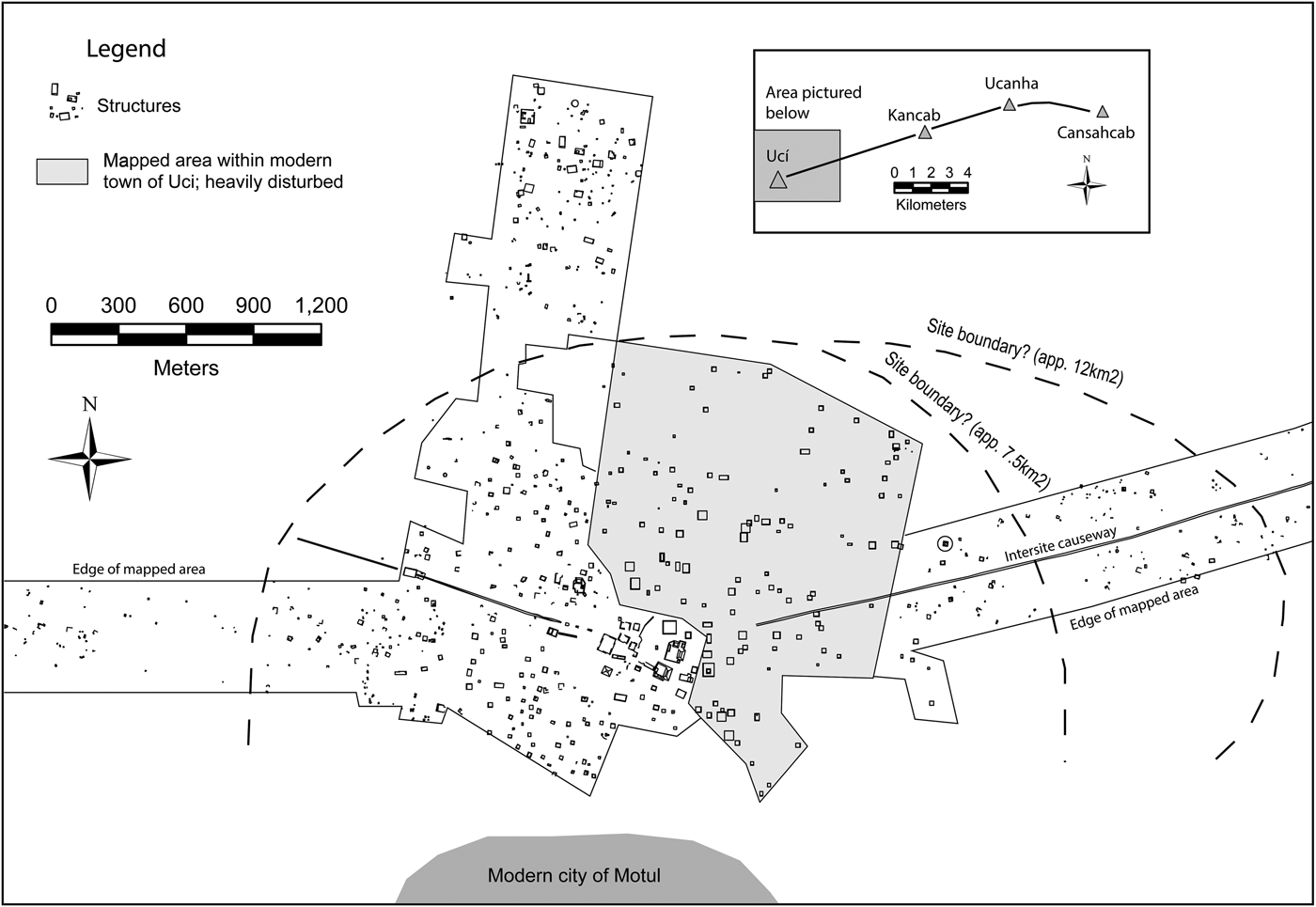
Map of Uci, Yucatan, Mexico, showing limits of mapped area and two postulated edges. The architecture pictured in Figure 6 comes from Structure 4n1, which is circled at the right. Map by Scott R. Hutson.
Causeways are not merely political symbols. Though a causeway may not be absolutely necessary for economic integration, various projects have generated data that suggest that causeways do indeed facilitate commerce (Carrasco Reference Carrasco and Perramon1993; Chase and Chase Reference Chase and Chase2001; Hassig Reference Hassig and Trombold1991; Hirth Reference Hirth2000:186–187). Causeways may also embody religious beliefs and serve as stages for rituals of various sorts (Hutson et al. Reference Hutson, Magnoni and Stanton2012; Keller Reference Keller, Lecount and Yaeger2010; Ringle Reference Ringle, Grove and Joyce1999). We discuss such beliefs and rituals below with reference to intrasite causeways at Ucanha and Kancab. Intrasite causeways, most of which are less than 500 m long, are far more common than intersite cuaseways (Shaw Reference Shaw2008). Given what we know about the blurred or nonexistent boundaries between politics, economics, and ritual among the ancient Maya (Masson and Freidel Reference Masson and Freidel (editors)2002; Wells and Davis-Salazar Reference Wells and Davis-Salazar2007), integration likely took multiple forms—political, economic, ritual, social (Chase and Chase Reference Chase and Chase2001; McAnany Reference McAnany2010:264; Shaw Reference Shaw2008).
The Atlas Arqueológico de Yucatan, which assigned sites to Ranks I through IV on the basis of quantities of large-scale architecture, established Uci as a Rank II site (Garza Tarazona de González and Kurjack Reference Garza Tarazona de González and Kurjack1980). Rank II sites are political centers with less population and fewer monumental buildings than Rank I centers. Of the four Rank I centers identified by the Atlas in the state of Yucatan (Chichen Itza, Izamal, T'iho–Merida, and Uxmal), only Izamal, located 37 km to the southeast of Uci, as the crow flies, was broadly contemporaneous with Uci and its causeway. The largest buildings at Izamal, and two other nearby Rank II centers (Ake and Dzilam), all share megalithic architecture, possibly indicating that these sites were part of a single larger political entity (Burgos Villanueva et al. Reference Burgos Villanueva, Reyna and Góngora2006:177). The Atlas project also documented two Rank IV sites along the Uci-Cansahcab causeway: Kancab and Ucanha. As discussed below, both of these sites contain housemounds clustered around a central plaza with large pyramids. The Atlas project assigned Cansahcab to Rank IV, although the site is heavily disturbed by the modern municipal center of the same name. UCRIP has found hundreds of housemounds scattered across the land beyond the ruins officially registered as sites by the Atlas. Most of these housemounds lack the kind of spatial clustering observable at Uci, Ucanha, and Kancab (see Figures 2, 3, and 4) and are therefore difficult to assign to discrete sites. After the Atlas surveys, Ruben Maldonado Cárdenas (Reference Maldonado Cárdenas and Pacheco1995) investigated Uci and its satellite sites between 1979 and 1982 as part of the Ake project.
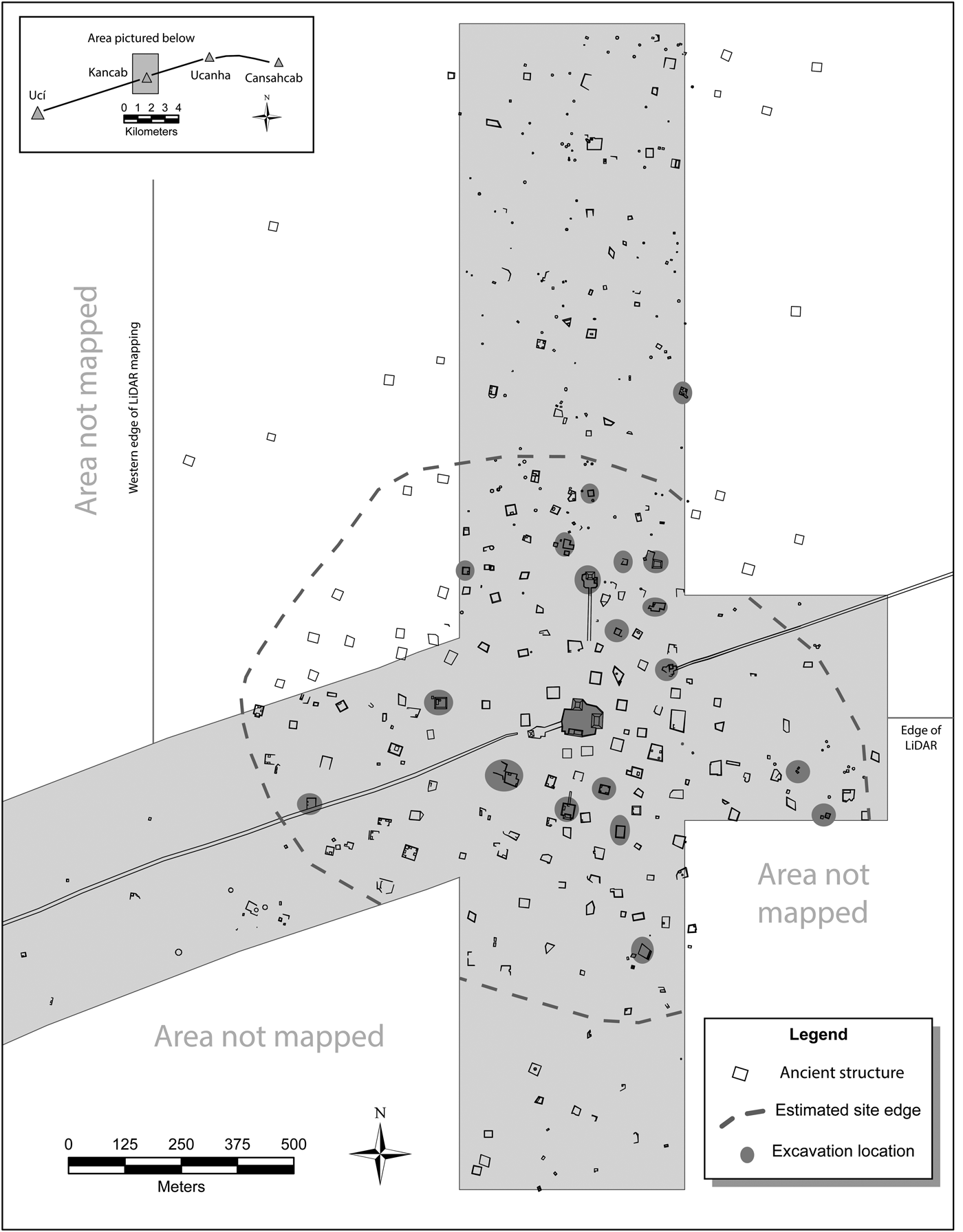
Map of Kancab showing proposed site edges (dotted line) and limits of LiDAR mapping. The large, light gray polygon represents the limits of pedestrian mapping. Architectural compounds that have received excavations or surface collections are circled. Map by Scott R. Hutson and Jacob A. Welch.
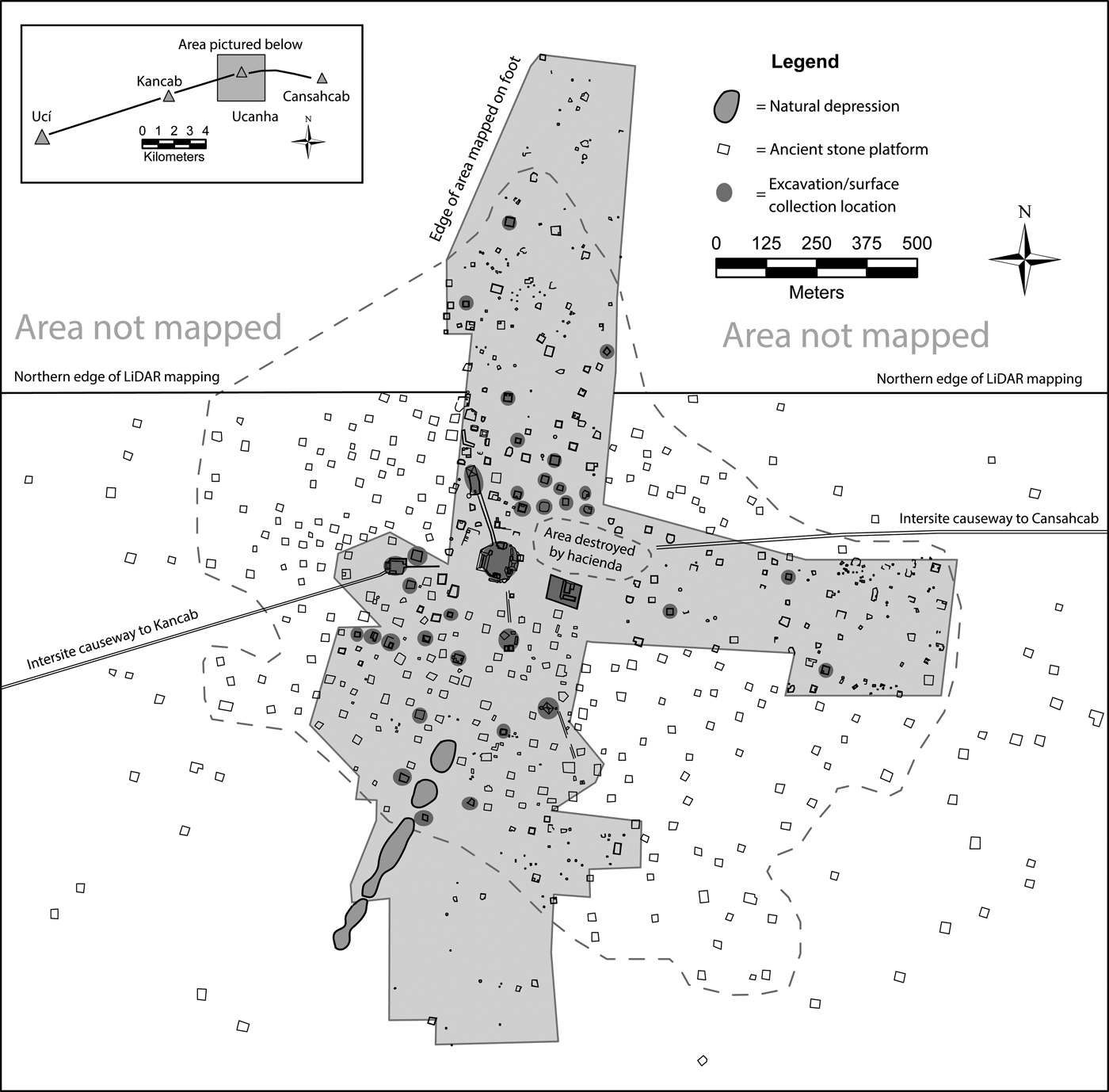
Map of Ucanha showing proposed site edges and limits of LiDAR mapping. The large, light gray polygon represents the limits of pedestrian mapping. Architectural compounds that have received excavations or surface collections are circled. Map by Scott R. Hutson.
The UCRIP project continues the work of the Atlas project and the Ake project. Though UCRIP has mapped and excavated a broad variety of locations in the vicinity of the Uci-Cansahcab causeway, this paper focuses on research at the three largest sites: Uci, Kancab, and Ucanha. UCRIP mapped the Uci site core with total station and then used GPS, tape, and compass to map other parts of the site as well as survey transects to the west, north, and east (see Figure 2). We did not map a south transect due to the proximity of the modern town of Motul to the south. The mapped transects to the west and north were 500 m and 600 m wide, and ended 2.9 km and 2.5 km from the site center, respectively. The 500 m–wide transect to the east of Uci, referred to as the causeway transect, follows the intersite causeway and extends 8 km to Kancab. Building on Maldonado Cárdenas' initial documentation of the site cores of Kancab and Ucanha, UCRIP mapped these site cores with a total station in order to produce digital elevation models of the largest architecture. The project also conducted pedestrian survey of settlement transects (500 m wide at Kancab, variable widths at Ucanha) extending out from the site cores and reaching beyond the site edges (Figures 3 and 4). UCRIP received 25 km2 of LiDAR data in an 11 km–long swath from Kancab to Cansahcab shortly before this article went to press. Though we have not yet excavated at Uci (and the Ake project's digs at Uci were relatively limited), we have test pitted dozens of locations at both Kancab and Ucanha (not to mention excavations at other sites not discussed in this paper). Surface collections have been made at very few structures because leaf litter and other organic debris generally obscure pottery on the ground. Even when organic material has been burnt off as part of the process of milpa farming, pottery is often absent. In spite of these difficulties, surface collections at 11 structures at Ucanha yielded enough sherds for chronological assessment. Figures 3 and 4 display the architectural complexes that have been test pitted or surface collected at Kancab and Ucanha.
Uci
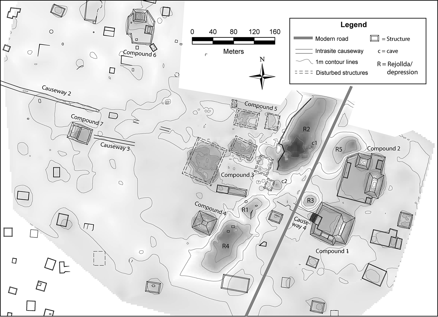
The site core of Uci lies on the southwest edge of the modern village of Uci. Though modern occupation of the village has resulted in poor preservation of the residential areas to the northeast of ancient Uci's site core (Figure 2), house platforms are still visible below modern houses and within modern houselots. The most heavily destroyed ancient structures within modern Uci are those located in the path of the grid of modern streets. Additional destruction has taken place beyond the village in the northwest part of the site core (Figure 5), where heavy machinery was used to extract building materials for the construction of the modern road between Motul and Telchac in the 1950s. Nevertheless, the total station map shown in Figure 5 reveals that the major elements of Uci's site core are still observable. These elements consist of a series of monumental architectural compounds surrounding a linear series of depressions (see Hutson and Covarrubias Reyna [Reference Hutson, Reyna, Arroyo, Paiz, Linares and Lucía Arroyave2011] for more detail about the site center). We return to the relation between the large architecture and the depressions in the section below on sacred landscapes. The Uci-Cansahcab causeway does not actually connect with any of the large compounds in the Uci site center. At 315 m east of the site core, the causeway definitively stops at a low platform located inside a modern houselot. Figure 5 shows the remnants of three other causeways, all running east-west and measuring 80 m, 100 m, and 1,500 m long.
Total station map of the Uci site core. Contour intervals are 1 m. Dark gray areas marked with an “R” are depressions known locally as rejolladas. Other gray areas are platforms above the natural ground surface. Note that Compounds 3 and 5 have been partially dismantled for road construction fill. Map by Scott R. Hutson.
Figure 5 shows that broad basal platforms, averaging about 400 m2 and 1 m high, surround the large architecture in the site center. Such platforms, though often smaller than 400 m2, also dominate other areas of Uci not pictured in Figure 5. Though the UCRIP has not yet conducted excavations on or around platforms of this size, they appear to be residential for three reasons. First, their size and dimensions are similar to basal platforms at nearby sites (Santa Teresa, Kancab, and the Yaxche area) which broad-scale excavations show to be residential. Second, several of Uci's basal platforms have smaller ancillary structures off their edges. Some of these are platforms with formal retaining walls, while others are chich mounds—small (< 25 m2), elliptical, low (< .5 m) piles of unworked stones (usually no longer than 15 cm) with no formal alignments. Ancillary structures often accompany residences at Classic Maya sites (Ashmore Reference Ashmore and Ashmore1981; Tourtellot Reference Tourtellot, Wilk and Ashmore1988) and these chich mounds may be ancillary structures. Third, some of the broad platforms support foundation braces for superstructures whose size (25–50 m2) approximates that of traditional Maya houses in the early twentieth century (Wauchope Reference Wauchope1938), as well as ancient houses excavated at nearby Dzibilchaltun (Kurjack Reference Kurjack1974). Those platforms without stone foundation braces likely supported perishable superstructures. Uci's broad platforms differ markedly from the more common plazuela groups of the southern Maya lowlands.
The 500 m–wide mapping transects to the west, north, and east of Uci permit an etic delimitation of the edges of the site (Figure 2). Though there are few areas around Uci that have no settlement whatsoever, reasonably clear drop-offs in settlement density present themselves on the west transect at 1.65 km from the center and on the north transect at 1.35 km from the center. The settlement documented at the north end of the north transect pertains to a site registered by the Atlas project as 16Q-d(5):14. To the east, there are two potential site edges, one located 1.65 km from the site center, the other located about 2.5 km from the site center. We favor the former site edge, thus embracing a conservative estimate for the amount of land covered by Uci: 7.5 km2.
Of Uci's estimated 7.5 km2, we have mapped 3.73 km2. Several factors compromise our ability to calculate settlement density. Though we mapped a significant sample (what we estimate to be half of the site), about 45% of what we mapped is within the boundaries of the modern town of Uci, where preservation is poor, likely leading to the underrepresentation of settlement density. Thus, our estimates do not use data on ancient remains in the modern pueblo. Another potential distortion factor is that systematic mapping of other sites in northwest Yucatan shows that settlement density may vary with distance from the site center (Hutson et al. Reference Hutson, Hixson, Magnoni, Mazeau and Dahlin2008; Ringle and Andrews Reference Ringle, Andrews, Wilk and Ashmore1988). To adjust for this, we divided the site into 200 m–wide concentric rings and calculated settlement density estimates for each ring. This procedure yields an estimate of 905 compounds that appear to be the architectural signatures of households. We follow the common definition of household as a group of people that share activities such as consumption, production, residence, reproduction, and transmission (Ashmore and Wilk Reference Ashmore, Wilk, Wilk and Ashmore1988:4). We use flexible criteria for what counts as the architectural signature of a household. The most common form of household architecture consists of a single, broad, basal platform (usually between 200 and 500 m2) that supported superstructures or a broad platform with one or more smaller structures within about 15 m. The variability in the size of domestic architecture suggests variability in the number of people pertaining to each household. Less common forms of household architecture include pairs of smaller platforms (100–300 m2) or a cluster of chich mounds not affiliated with a broad platform. Though there is a precedent for identifying isolated chich mounds as residences (Ringle and Andrews Reference Ringle, Andrews, Wilk and Ashmore1988:182–185), we took the conservative position of not counting them as dwellings since none have been excavated thus far at Uci. With 905 architectural compounds in an area of 7.5 km2, Uci's settlement density is 121 households per km2.
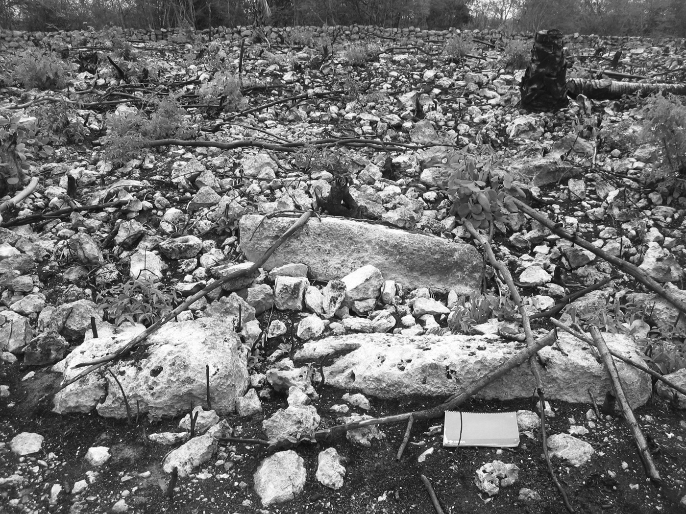
Surface collections and a small sample of test pits reported by Maldonado Cárdenas (Reference Maldonado Cárdenas1982) suggest that Uci reached the height of its occupation in the latter part of the Late Preclassic period (a.d. 1–250) and continued into the Early Classic period (a.d. 250–600). This impression, which UCRIP will evaluate more thoroughly in the future, is supported by additional lines of evidence. Many of the platforms pertain to the domestic megalithic construction style, which features large, dressed facing stones laid horizontally in the construction of platform retaining walls (see also Stair Reference Stair2014) (Figure 6). Extensive UCRIP excavations at Kancab, Ucanha, Santa Teresa, and the Yaxche survey area, as well as research from other parts of Yucatan (Mathews Reference Mathews2001; Mathews and Maldonado Cárdenas Reference Mathews, Cárdenas, Mathews and Morrison2006), show that megalithic platforms date to the latter part of the Preclassic period and the beginning of the Early Classic period. Since megalithic platforms from sites near Uci date to the Late Preclassic and Early Classic, those at Uci probably share this chronology as well.
Megaliths in the retaining wall of Structure 4n1, an example of a small-scale megalithic platform. The gray rectangle in the lower right corner is a notebook measuring 26 cm long.
Kancab
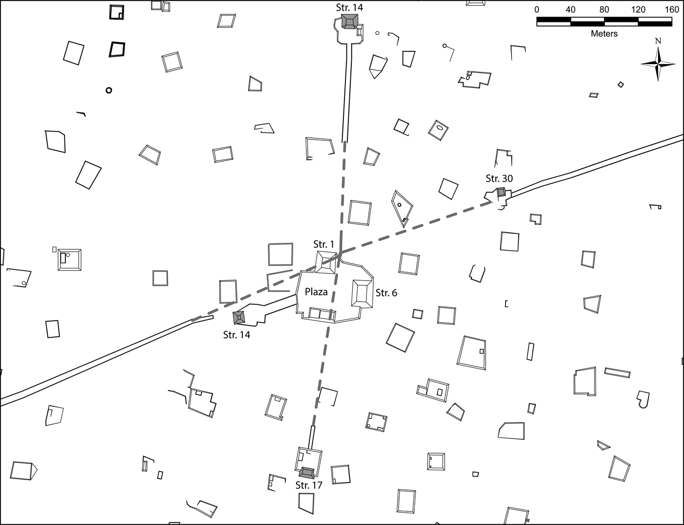
The Kancab site center (Figure 7) is much smaller than Uci's (Figure 5). It consists of a central plaza with a pair of mounds (Structures 1 and 6) rising to a height of 7.5 m. The next three highest mounds at the site—Structures 44, 14, and 17—reach heights of 5.8 m, 5 m , and 3.5 m above the natural ground surface and are located to the north, west, and south of the central plaza, respectively. Though we hesitate to call these buildings monumental, their size stands out from the rest of the site's buildings. Their placement on spacious platforms with connections to intrasite causeways suggests that they hosted larger and more frequent ceremonies than smaller architectural compounds. We call these compounds ceremonial groups while also recognizing that lower structures on top of the platforms may have been residences. In contrast to the Uci site center, which encircles a series of depressions, Kancab's site center is built on a slight topographic rise. The nearest depression is a quarry 120 m south of the site center. This quarry is smaller (16 m long) and shallower (1.5 m deep) than any of the central depressions at Uci, some of which extend over 50 m long with a depth of 5 m. Beyond the site core, small-scale megalithic platforms are common, much like at Uci. Some of these broad platforms support stone foundation braces, although most platforms would have supported entirely perishable superstructures. Our survey of the four cardinally oriented mapping transects identified reasonably clear drop-offs in settlement density in all directions (Figure 3). The drop-offs are located 710 m, 550 m, 550 m, and 640 m from the site core on the west, north, east, and south transects, respectively. These data produce an amoeba-shaped site with an etic size estimate of 1.25 km2.
Map of the central portion of Kancab, Yucatan, Mexico. Note the locations of Structures 44, 30, 17, and 14, each placed in one of the four cardinal directions. The corresponding causeways have been extended (dashed lines) to show how they would converge at a single point in the site center. Map by Scott R. Hutson.
Of the estimated 1.25 km2 pertaining to Kancab, .978 km2 were mapped on the ground, with LiDAR covering an additional .165 km2. In these 1.143 km2 we identified 140 architectural compounds that appear to be the material signatures of households. Settlement density is thus estimated at 122 households per km2, which is very close to the 121 households per km2 estimated for Uci. The UCRIP has conducted excavations in the east causeway terminus mound (Structure 30), 15 domestic platforms (a sixteenth is to the north but outside our boundaries for the site), and two of the ceremonial groups mentioned above (the main plaza and Structure 44) (see Figure 3). The 15 domestic platforms tested comprise a 12.5% sample of household compounds at the site. Fourteen of the fifteen domestic platforms yielded pottery that dates to the Late Preclassic and/or Early Classic periods (ceramic groups include Xanaba, Saban, Shangurro, Sierra, Tipikal, Unto, Huachinango, Carolina, Timucuy, Tituc, and others). At least eight of these platforms may have earlier occupations, given that they contained ceramics from groups first produced in the Middle Preclassic such as Joventud, Chunhinta, and Dzudzuquil. Most excavation contexts also have a substantial amount of pottery from the Late/Terminal Classic (a.d. 600–1000) and Postclassic periods (a.d. 1000–1547). These chronological data suggest that most of the architecture visible today was occupied at the time when the causeway from Uci met up with the site of Kancab. Though Kancab and Uci have nearly identical settlement densities, Kancab is about a sixth the size of Uci, regardless of how one measures size (Table 1). For example, Kancab covers 16.7% of the area covered by Uci, and our estimates suggest that it has 16.3% of the household compounds. Comparison of the largest buildings in the two site cores shows that the volume of architecture at Kancab is 17.3% of that present at Uci. This percentage should probably be smaller given that portions of two large architectural compounds (Compounds 3 and 5; see Figure 5) at Uci were removed for road construction fill in the 1950s. Arranged differently, these data show that both communities have about the same amount of large architecture per household (see Table 1).
Site data for Uci, Kancab, and Ucanha. All three sites have major occupations at the end of the Late Preclassic
Ucanha
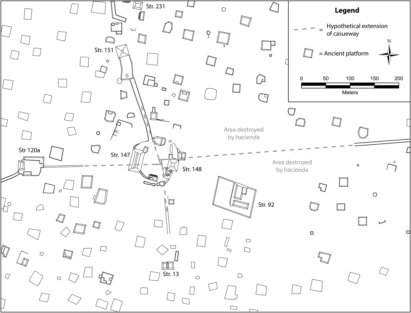
Ucanha is larger than Kancab but smaller than Uci (see Table 1). Ucanha's site core (Figure 8) closely resembles that of Kancab (Figure 7). The site has a main group with pyramids on the west (Structure 147) and east (Structure 148) sides, measuring 8.5 and 7.7 m high, respectively. Pyramids to the north (Structures 151 and 231), west (Structure 120a), and south (Structure 1) reach heights of 10 m, 4.2 m, and 7.3 m high, respectively. These pyramids are part of ceremonial groups that may also contain residences. Unlike Kancab, Ucanha has a palace east of the central plaza measuring 80 × 55 m. Beyond the site core lie hundreds of broad, low platforms, most of which exhibit the megalithic style discussed above. A series of linear depressions much like those at Uci lie to the southwest of the Ucanha site core, yet most of this low ground falls outside our boundaries for the site.
Map of the central portion of Ucanha, Yucatan, Mexico. Causeway termini structures and other structures mentioned in the text have been labeled. The causeways have been extended (dashed lines) to show how they would converge at a single point in the site center. Many of the structures south of the site center were first presented in Maldonado Cárdenas (Reference Maldonado Cárdenas and Pacheco1995). Map by Scott R. Hutson.
Regarding etic site size, 1.4 km2 of mapping with total station or tape and compass and a large swath of LiDAR data suggest that Ucanha covered 2.205 km2, 0.116 km2 of which falls beyond the area for which we have data. Within the 2.089 km2 that we mapped, we located 388 architectural compounds that appear to be the architectural signatures of households. As the map in Figure 4 shows, a 4 ha area directly to the east of the main group lacks pre-Columbian architecture. This is where a variety of edifices pertaining to an early twentieth-century henequen hacienda were built. We believe that about six ancient architectural compounds were destroyed in the construction of the hacienda. If we add these six “missing” household compounds, the data yield a settlement density of 189 households per km2, which is considerably denser than both Kancab and Uci. Given this density, we estimate that another 22 households are located in the 0.116 km2 that we did not map. Since UCRIP excavations at Ucanha continue as we publish this paper, we do not yet know when most of Ucanha's residences were occupied. Nevertheless, preliminary analysis of ceramics from excavations completed thus far suggests that much of Ucanha, including the main plaza, the palace, and many residential platforms underwent major construction episodes during the late part of the Late Preclassic (a.d. 1–250) (Kidder et al. Reference Kidder, Hutson and Stevenson2014).
Given that Ucanha had three times the amount of residential architecture as Kancab (see Table 1), it comes as no surprise that it also had substantially more large architecture, much of it ceremonial. The volume of Ucanha's main group (Structures147 and 148, and the basal platform that supports them), palace (Structure 92), and pyramids (Structures 1, 13, 120a, 151, and 231) is about 36,000 m3, which contrasts with a volume of about 20,000 m3 for Kancab's main group (Structures 1, 6, and the basal platform that supports them) and pyramids (Structures 14, 17, and 44). Uci's seven largest compounds have a volume of roughly 110,000 m3, though the actual volume was higher before fill was taken for road-building in the 1950s.
Summary: Uci, Kancab, and Ucanha
In summary, Kancab has about a third the number of households as Ucanha, which has, in turn, fewer than half of the estimated households at Uci (Table 1). Furthermore, Ucanha has nearly double the volume of large architecture of Kancab, and Ucí has at least three times as much large architecture as Ucanha. It is interesting to note the relatively high volume of architecture per household at Uci compared to Ucanha. Did Uci's leaders draw labor from sites like Ucanha? We cannot answer this question since we lack precise construction histories for the largest mounds. It is possible, however, that the largest structures resulted from a variety of building episodes and therefore may not inform us about the control of labor at any one point in time. Despite differences in size and large architecture, all three sites had similar kinds of domestic architecture (megalithic platforms), and were occupied heavily during the Late Preclassic and Early Classic periods, when the causeway was most likely built.
SACRED LANDSCAPES
In terms of sacred landscape, Uci differed significantly from Kancab and Ucanha, as the following section highlights. The most distinctive feature of Uci's site center is that its five largest architectural compounds (Compounds 1 through 5) cluster around a linear series of depressions. Of these compounds, preservation is good enough in four of them to determine the direction in which they face, and that direction is inward, toward the depressions. In other words, Compounds 1 and 2, on the east side of the depressions, face west. Compounds 3 and 4, on the west side of the depressions, face east. The depressions at the site core are naturally occurring dry sinks. These karst features, called rejolladas, are more common in the center of the Yucatan Peninsula, to the east of Uci (Houck Reference Houck, Mathews and Morrison2006; Kepecs and Boucher Reference Kepecs, Boucher and Fedick1996). The linear alignment of the rejolladas at the center of of the site indicates that they formed over a fracture in the limestone shelf (Mandy Munro-Stasiuk, personal communication 2013). Both pedestrian survey and LiDAR survey reveal only one other linear cluster of rejolladas in the area, located on the southwest edge of Ucanha. Rejollada 2, the largest of the rejolladas at Uci's site core, measuring about 160 × 70 m, contains two small caves that reach the water table, providing a source of water year-round. The entrances to both caves are less than 100 m from contemporary houses and have been visited and cleaned by modern inhabitants of Uci several times. If there were artifacts on the surface, they are gone today. During the rainy season, vernal pools form in the deepest part of Rejolloda 2, about 6 m below the natural land surface. This area is unnaturally deep, as modern residents of Uci have told us that bulldozers modified it in the 1950s. Adjacent piles of fractured bedrock also suggest the use of bulldozers. The bulldozers, however, did not touch the caves. We do not see evidence (quarrying scars, partially removed blocks) of ancient quarrying in this rejollada. Nearby sites with even larger architecture lack such depressions in their site cores; the largest buildings at nearby Izamal and Ake, for example, cluster around a central plaza, not a depression.
The association between the rejolladas and Uci's largest buildings does not seem random: the likelihood that people unintentionally built the largest structures in a 20 km radius next to this rare collection of rejolladas is very low. In Yucatan, modern communities and ancient communities often built the centers of their settlements around openings in the earth, such as caves and waterholes. They serve not just as year-round sources of water, but also as ritually important places. Archaeologists and epigraphers have argued that caves for the ancient Maya signified houses of the gods, openings to the underworld, and places of creation (Brady Reference Brady1997; Prufer and Brady Reference Prufer, Brady, Brady and Prufer2005; Vogt and Stuart Reference Vogt, Stuart, Brady and Prufer2005). In other northern lowland caves and cenotes, such as Balancanche (Andrews Reference Andrews1970), the Cenote of Sacrifice at Chichen Itza (Coggins and Shane Reference Coggins and III1984), Gruta de Chac (Smyth Reference Smyth2012), and Ikil (Slater Reference Slater2014), the ancient Maya performed ceremonies associated with rain. A review of ethnographies on highland Chiapas, Mexico, shows that caves are seen as borders between natural and supernatural, portals to the underworld, and the source of lightning, thunder, clouds, and rain. Vogt and Stuart (Reference Vogt, Stuart, Brady and Prufer2005:180) state that in these capacities “caves were key elements in defining the religious and even political identity of ancient urban communities.” At many sites, rulers attempted to appropriate these sacred landmarks by locating major temples and palaces in relation to them, either by building on top of them, beside them, or linking to them with causeways (Brady Reference Brady1997; Brady and Ashmore Reference Brady, Ashmore, Ashmore and Knapp1999; Halperin Reference Halperin, Brady and Prufer2005; Vogt and Stuart Reference Vogt, Stuart, Brady and Prufer2005). According to Brady (Reference Brady1997:614), the cave “sanctifies the site and defines it as the cosmic center, in the process legitimizing the site and the political organization that stands at the center.” Along these lines, we believe that by siting their largest compounds in such a way that they envelop the depressions and caves, the leaders of Uci created an ideological landscape. Not only did these leaders harness a sacred geography in order to gain access to rain and the gods, but by appropriating this rare complex of depressions, they may have attempted to encourage the notion that they had privileged access to the sacred.
At the same time, the plans of Kancab and Ucanha suggest that Uci was not the only site that embraced a landscape calibrated to access the sacred. Kancab has four causeways (Figure 7)—one to the north of the site center, one to the south, one to the west, and one to the east. The sacbe to the east of the site center is the portion of the Uci-Cansahcab causeway that links Kancab with Ucanha. Ucanha also has causeways in these four directions (Figure 8). At both Kancab and Ucanha, the relatively short causeways on the north, west, and south link or almost link an outlying ceremonial group (consisting of a pyramid and a plaza; see above) to the main group. Such a pattern of relatively short causeways that link major architectural groups has been noted at many different Maya sites in the northern Maya lowlands such as Chichen Itza, Chunchucmil, Coba, Cozumel, Dzibilchaltun, Ek Balam, Komchen, Sayil, Labna, and Yaxuna. The most common explanation of the function of these kinds of causeways is that they hosted ritual processions (Freidel and Sabloff Reference Freidel and Sabloff1984:2; Shaw Reference Shaw2008:120; Tourtellot et al. Reference Tourtellot, Sabloff, Smyth, Whitley, Walling, Negrón, Álvarez, Andrews and Dunning1988). Ringle (Reference Ringle, Grove and Joyce1999) argues that in the Late Preclassic period, these processions helped integrate communities by linking the core with outliers while at the same time legitimating the authority of the community's leaders.
The presence of causeways that are roughly oriented to the cardinal directions and that link, or nearly link, with the main group in the site center suggest a representation of a world with four quarters and a center—a quincunx. Mayanists have found evidence of such representations at many scales: in iconography, individual artifacts, arrangements of multiple artifacts in caches, other structured deposits, single buildings, and layouts of multiple buildings and other features (Ashmore Reference Ashmore1991; Coggins Reference Coggins1980; Estrada Belli Reference Estrada-Belli2006; Fedick et al. Reference Fedick, Mathews and Sorenson2012; Maca Reference Maca, Robertson, Seibert, Fernandez and Zender2006; McAnany Reference McAnany1995; Tourtellot et al. Reference Tourtellot, Wolf, Smith, Gardella and Hammond2002). The meaning of these representations, however, is not straightforward. For at least 50 years, scholars have explicitly discussed the symbolism of cardinal orientations among both past and present Maya. Our own reading of this literature highlights two interpretations that are not mutually exclusive. In the first interpretation, deftly explored by Coggins (Reference Coggins1980), crosses, quartered circles, and other quadripartite figures represent the path of the sun, with east as sunrise, north as zenith, west as sunset and south as nadir. This interpretation, drawn heavily from pre-Columbian iconography, sees four-part figures as illustrations of the shape of time as well as microcosms of the Maya universe, in which the passage of the sun and other celestial bodies connect the natural world with the heavens (north/up, linked to royal ancestors), and the underworld (south/down, linked to the underworld). Following this logic, laying out key aspects of the core of one's town in the form of a quadripartite figure places that town in the center of universe, around which the sun travels.
The second interpretation, exemplified by Freidel et al. (Reference Freidel, Schele and Parker1993), views pre-Columbian iconography from the perspective of contemporary Maya ritual and worldview. Detailed ethnographies (for example, Hanks Reference Hanks1990) document practices of centering, in which, for example, shamans create altars with four sides, four corners, and a center. According to Freidel et al. (Reference Freidel, Schele and Parker1993:130–131), the shaman's act of centering accomplishes many things. Centering creates a portal for accessing supernatural entities, it creates a “spatial order that focuses the spiritual forces of the supernatural within the material forms of the human world,” and it references the Popul Vuh creation myth in which the First Father raises the sky and builds a four-quartered house. Actively moving from the center point—the axis mundi—to the four corners and back appears to accomplish two things: (1) reenactment of the creation, which invests the participants in the ritual with the creative power of those supernatural beings responsible for creation, and (2) the opening of a portal to the underworld, which provides access to supernatural beings (Mathews and Garber Reference Mathews and Garber2004).
These and other interpretations of quadripartite and quincunx arrangements overlap. They both suggest that Kancab's and Ucanha's four causeways and central plaza were arranged to “symbolically equate the architectural center of civic power with the center of the universe” (Ashmore Reference Ashmore1991:200; see also Robin et al. Reference Robin, Kosakowsky, Keller and Meierhoff2014). Did commoners from small centers such as Kancab and Ucanha understand quincunx symbolism? Finds from Belize suggest that modest farmers not only understood quincunx symbolism but replicated it in their own deposits and buildings. For example, Robin (Reference Robin2002) excavated a quincunx-shaped cache of cobbles in a modest rural residence at Chan, Belize, while Zaro and Lohse (Reference Zaro and Lohse2005) excavated a nonelite architectural group with a quincunx layout that marks the solstice and zenith passages near Blue Creek, Belize.
At the same time, there are reasons to be skeptical of studies that identify buildings, site plans, and other materials as representations of Maya cosmology. In particular, Michael Smith (Reference Smith2003, Reference Smith2005:220) believes that these identifications lack methodological rigor. In his words, in their “desire to reconstruct ancient cosmology from fragmentary evidence,” researchers fail to present multiple lines of evidence, act selectively in terms of what data they present, and do not state the selection criteria. Second, Smith believes these researchers lack humility—they present what he calls speculations as if they were confident conclusions.
Regarding Smith's second criticism, we agree that it is important to be humble because we lack texts and images from Kancab and Ucanha dating to the time in which the causeways were constructed that (1) describe the layouts of the cosmos and the ideal town, and (2) state that leaders deliberately followed these ideals when laying out their own town. Nevertheless, heeding Smith's first criticism, we believe it is possible to build a plausible and rigorous argument that built features at Kancab and Ucanha materialized a quadripartite world view. Adding rigor to the data already presented begins by affirming that data presentation is not selective, in that the maps presented in Figures 3, 4, 7, and 8 show all features mapped, not just those that conform to a potentially preconceived idea of site planning. Our data presentation is also not selective because only 5% of Ucanha and 8% of Kancab remain unmapped. In other words, the likelihood of the existence of not-yet-mapped causeways within Ucanha and Kancab that would spoil these sites' clear quincunx patterns sites is very low.
Given that our data are not selective, and should therefore be considered as reasonable representations of all that was (and was not) built, the argument that the layouts of the causeways and main plazas at Kancab and Ucanha represent a quincunx also gains strength by considering the unlikeliness that such a layout was built at both sites, purely by chance, with no intention of representing a quincunx. Our proposal is that the leaders of Kancab and Ucanha built a quadripartite plan because they thought that their followers would recognize the quadripartite symbolism and therefore join them in conceiving of the site center as a legitimate axis mundi and portal to the gods. If building a quadripartite site plan were just an idiosyncratic pursuit of leaders at Kancab and Ucanha, rather than a more broadly understandable strategy grounded in cosmological principals intelligible to other lowland Maya people, we would not expect to find evidence of quadripartite planning at any other sites. Yet we do see quadripartite site layouts at several other centers such as Chunchucmil (Hutson Reference Hutson2010:49) and Ek Balam (Bey et al. Reference Bey, Hanson and Ringle1997), Yucatan, La Milpa (Tourtellot et al. Reference Tourtellot, Wolf, Smith, Gardella and Hammond2002) and Xunantunich (Keller Reference Keller, Lecount and Yaeger2010), Belize, and T'isil, Quintana Roo (Fedick et al. Reference Fedick, Mathews and Sorenson2012). Obviously there was communication between people of Ucanha and Kancab, and this probably goes part of the way in explaining the similarity in site layout. But if that same layout is expressed in various media at many other sites and reflects a well-documented and widespread cosmological principal, a parsimonious explanation for some of the similarity is that there is an actual connection between that principle—the quadripartite worldview—and the physical phenomena in question.
Another means of adding rigor comes from strengthening the analogy made between the subject (the pattern seen at Ucanha and Kancab) and the source (the iconography and epigraphy from codices and other ancient Maya sites as well as ethnography and ethnohistory). The analogy is already strong given that the people on both the subject and source sides speak/spoke the same languages, share a subsistence system based on maize agriculture and, living on the same land, faced similar constraints in terms of climate, seasonality of rains, and fragile tropical soils. Furthermore, this subsistence base is closely connected to aspects of a quadripartite cosmology, particularly that movements of the sun and other celestial bodies have direct impact on farming.
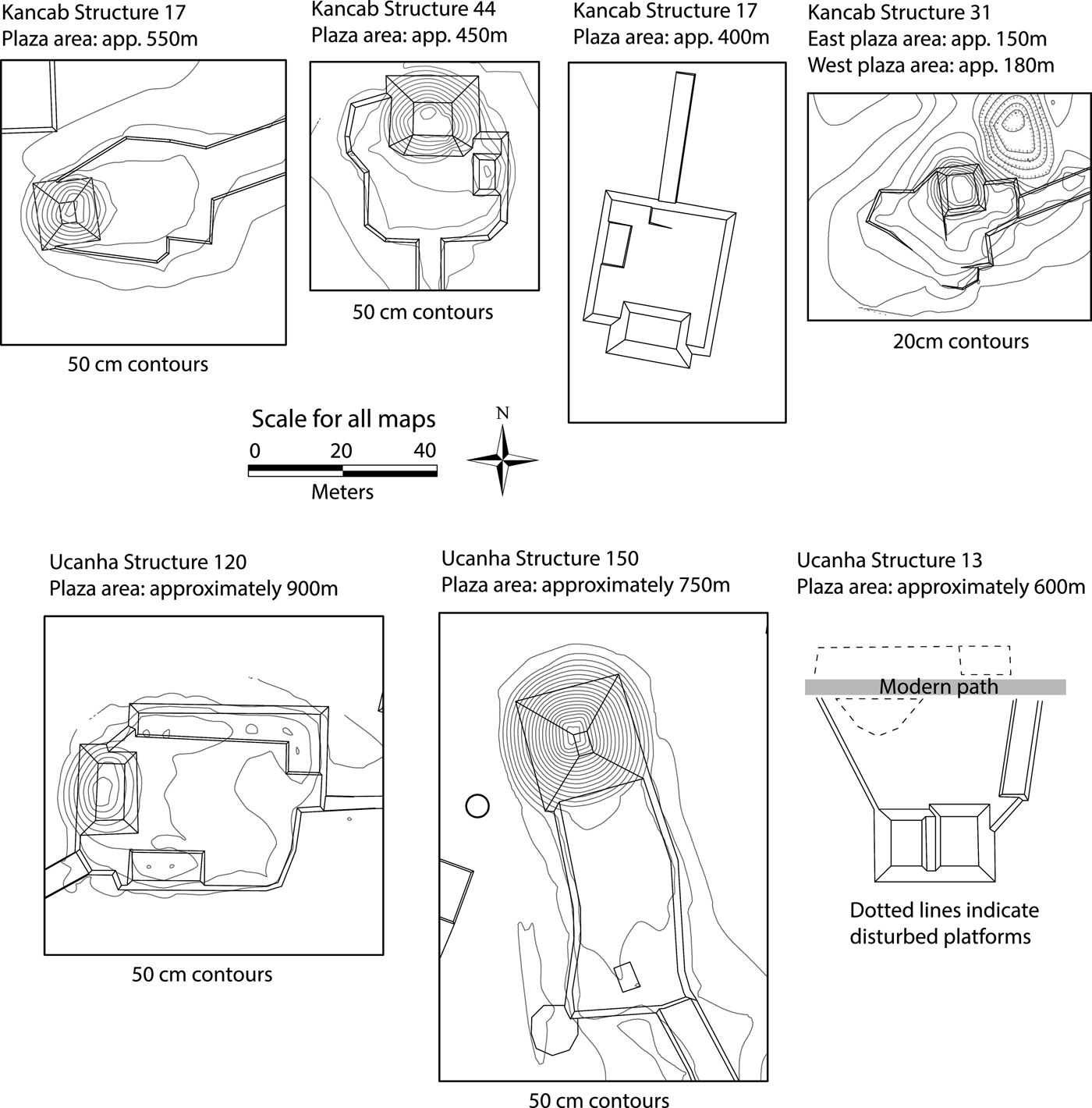
Closer attention to detail on the source side and the subject side further strengthens the analogy and draws out its relational nature (Wylie Reference Wylie and Schiffer1985). On the source side, one of the clearest descriptions of quadripartite cosmology, as it relates to town planning, comes from Landa's description of Conquest-era towns in Yucatan. Landa describes roads placed at cardinal directions, as well as a pair of what he referred to as stone heaps along each road at the edge of town (Tozzer Reference Tozzer1941; see also Coe Reference Coe1965). At the end of each year, townspeople paraded from the center of the town to the stone heaps at each of the four cardinal directions and performed rituals in front of idols placed at the heaps. With the exception of the east causeways at both Kancab and Ucanha, the other causeways at each site link with architectural compounds consisting of a pyramid on top of a broad platform (Figure 9). Earlier we referred to these architectural compounds as ceremonial. Following several other writers who have discussed intrasite causeways (Freidel and Sabloff Reference Freidel and Sabloff1984:2; Shaw Reference Shaw2008:120; Tourtellot et al. Reference Tourtellot, Sabloff, Smyth, Whitley, Walling, Negrón, Álvarez, Andrews and Dunning1988), we propose that they are places where processions stop for rituals, much like the stone heaps at the ends of the main avenues in the contact-era towns described by Landa (see Tozzer Reference Tozzer1941). Assuming a conservative estimate of 2 m of space per person (Inomata Reference Inomata2006), each platform could have hosted over 200 visitors (see Figure 9). The platforms at Ucanha, the larger site, are larger. Regarding the east causeway exceptions, the pyramid at the east causeway terminus at Kancab (Structure 30) has no substantial platform to host a crowd and the causeway extends eastward away from the Kancab site core whereas the other three pyramids at Kancab have causeways extending toward the site core. At Ucanha, there is no east pyramid, perhaps because of historic period destruction. The east causeway approaches the edge of the 4 ha area occupied by the buildings of the historic-period hacienda and then simply disappears without a formal stopping point.
Map of ceremonial compounds located at causeway termini at Kancab and Ucanha. Map by Scott R. Hutson.
The analogy between the ceremonial compounds on the causeways and the paired stone heaps on the cardinally oriented roads reported by Landa at the edge of Contact-period towns (Tozzer Reference Tozzer1941) can be judged formally and relationally, as Wylie advocates. In terms of form, the analogy is inexact because paired stone heaps are different from pyramids on platforms and because we only have solid evidence for ceremonial compounds in three cardinal directions at each site as opposed to four. The relational analogy fares well because the pyramids were likely ritual spaces whose abutting plazas easily could have hosted the kinds of ceremonies and processions discussed by Landa at the four corners of Conquest-era towns. Furthermore, excepting Structure 30 at Kancab, the compounds connected to the causeways at Kancab and Ucanha definitively face the center of the site, the direction from which processions would have arrived.
Finally, the case for a quadripartite plan gains additional rigor if evidence can be marshaled to show that the different elements of the quadripartite design were planned with reference to each other. As each of the four causeways at both Ucanha and Kancab approach the site center, they have a predominant orientation. Though the causeways do not actually extend far enough into the center to intersect each other, if the causeways were extended using the predominant orientations, as is shown hypothetically in Figures 7 and 8, they would come quite close to intersecting at a single point for each site (compare against Normark Reference Normark2008). At Kancab the hypothetical point of intersection is on the main plaza adjacent to one of the site's two largest mounds, Structure 1. At Ucanha, the hypothetical point of intersection is near the center of the main plaza. These alignments suggest that the builders coordinated the orientations of the causeways so that they would create a cross with a single point of intersection. As for chronology, six of the seven architectural complexes with pyramids (Structures 17, 30, and 44, at Kancab; Structures 13, 120, and 151 at Ucanha) received test pits. Ceramics from these pits revealed the basal platforms to have been constructed in the Late Preclassic. If the four causeways and their architectural complexes were not built at precisely the same time, the orientation data suggest that the last two causeways to be built at each site were planned in such a way that their alignments pointed directly to the first two causeways' hypothetical point of intersection at each site. We admit there is room for debate at Kancab. There are two distinct causeways on the west side—one intersite and one intrasite—and if one uses the orientation of the intrasite causeway as opposed to the intersite causeway, the four causeways clearly do not intersect each other at the same spot.
In sum, we argue that aspects of the site plans at Kancab and Ucanha were intentionally built as a quadripartite, or quincunx, design whose meanings were consonant with interpretations commonly given for quadripartite designs elsewhere in the Maya area—as microcosms of Maya time and universe, and as portals to the gods. The people of Kancab and Ucanha created an axis mundi that centered their communities and gave them access to the sacred (see also Stanton and Freidel Reference Stanton and Freidel2005). The cross-shaped plan of causeways with temples at the corners and the main plaza at the center both represents and facilitates agency (Barrett Reference Barrett and Hodder2001:157). The plan represents agency because the people of Kancab and Ucanha could have done otherwise. In particular, the people of Ucanha chose to live very close to a series of depressions nearly identical to those found at the Uci site core. Like the linear depressions at Uci, those at Ucanha also contain caves and year-round sources of water. But whereas the people of Uci harnessed the sacred power of these depressions by building their largest structures around the depressions' edges, the people of Ucanha literally left their own depressions off to the side, choosing instead to create a sacred center from scratch over 400 m to the north of the depressions. The people of Ucanha were not completely oblivious to natural caves with water; they built some of their largest structures close to smaller caves, and they might have chosen the precise location of the palace because it is roughly in line with the linear depressions to the south. Yet, unlike at Uci, natural caves were not the focal points of site planning at Ucanha and Kancab.
Regarding whether or not Kancab and Ucanha's layouts facilitated agency in Barrett's (Reference Barrett and Hodder2001:157) sense, we envision the quadripartite axis mundi as a technology to be used in performances which renewed and fortified both communities. Insofar as this ritual technology was contemporary with the cave-focused sacred landscape of Uci, we conclude that Uci did not hold a monopoly on community ritual practice. Though Uci was much larger than Kancab and Ucanha and subsumed these sites by linking to them with an intersite causeway, the people at Kancab and Ucanha managed to maintain a degree of ritual autonomy. At the same time, the fact that the practice of creating a symbolic center is common in contexts ranging from households to political capitals suggests that the people of Uci may never have even thought of monopolizing something so basic as access to the sacred. Thus, the copresence of two contrasting sacred landscapes may not speak to the issue of explicit negotiations between a superordinate site and its subordinates. Nevertheless, the site layouts at Ucanha and Kancab speak to more basic notions of power; carrying out an intentional plan that makes the community socially and ritually viable through the reproduction of cosmological structures (Dobres and Robb Reference Dobres, Robb, Dobres and Robb2000:9; Lohse Reference Lohse, Gonlin and Lohse2007).
MEGALITHIC ARCHITECTURE
Megalithic buildings of the northern lowlands have made a strong impression on travelers and archaeologists beginning with the first writers to describe them (Brasseur de Bourbourg Reference Brasseure de Bourbourg1865; Charnay Reference Charnay and Viollet-le-Duc1863; Stephens Reference Stephens1843). Stephens (Reference Stephens1843:304), who saw the megalithic monumental architecture at Dzilam, Izamal, and Ake in 1839, described the immense staircase of Structure 1 at Ake as “an approach of rude grandeur, perhaps equal to any that ever existed in the country.” When these sites were explored more systematically, it became clear that megalithic stones were used both in large-scale and small-scale buildings (Maldonado Cárdenas Reference Maldonado Cárdenas and Pacheco1995). “Large-scale” includes buildings like Structure 1 at Ake, which, measuring nearly 100 m in length and 10 m in height, surely counts as monumental. A building like Structure 6 at Kancab, measuring 32 × 25 × 7.5 m, may not fit some archaeologists' idea of monumental but nevertheless counts as “large-scale” because it is the largest building at the site. “Small-scale” refers not to the smallest buildings (though some of the smallest do have megaliths), but to platforms throughout the Uci-Cansahcab area that usually cover between 200 m2 and 500 m2 in area, and usually stand less than 2 m high. Both small-scale and large-scale megalithic buildings often have rounded corners. Though the stones in small-scale megalithic platforms are generally smaller than those in large-scale megalithic buildings (Stair Reference Stair2014), they have the same soft-edged “pillow” shape (Mathews and Maldonado Cárdenas Reference Mathews, Cárdenas, Mathews and Morrison2006; Taube Reference Taube, Fedick and Taube1995). Small-scale megalithic platforms, however, lack two common features of large-scale megalithic buildings—the broad stairways described by Stephens and megalithic apron moldings. Most of the retaining walls of small-scale megalithic platforms are not made entirely of megalithic stones (Stair Reference Stair2014). UCRIP mapping at Uci and its hinterland shows that the megalithic style was common in (small-scale) buildings from sites at all ranks of the settlement hierarchy. In more than 65% of the architectural compounds thus far mapped on foot at Ucanha and Kancab, the primary structure is built in the megalithic style.
We want to know how this style came to be used in both small- and large-scale contexts within the same microregion (see Mathews and Maldonado Cárdenas [2006] on the use of this style in other regions of Yucatan). The situation at Uci, Kancab, and Ucanha, where modest dwellings and larger buildings share key features, frequently occurs in prehistoric contexts. The phenomenon is well known in the eastern Mediterranean during the Bronze Age. For example, late Bronze Age Mycenaean palaces (1600–1100 b.c.) have a core plan—a long rectangular room with a vestibule at one end—that developed out of house plans that were common in the slightly earlier Middle Helladic phase (2000–1600 b.c.) (Castleden Reference Castleden2005:115). This core plan survives in several Classical Greek temples, which were houses writ large, albeit houses for deities (Carpenter Reference Carpenter1962:216–218). Excavations at the Minoan site of Vronda provide an even closer analogue to the Uci case because the public and private structures (in this case a community shrine and common houses) that share the same plan (vestibule and larger rectangular room) date to the same time period (Glowacki Reference Glowacki, Westgate, Fisher and Whitley2007). It should be noted that many Minoan and Mycenaean dwellings do not have the vestibule and central room plan (Carr-Rider Reference Carr-Rider1964). Likewise, at Uci, many small-scale platforms are not megalithic.
In such cases where practices found in households of lesser status are also found in association with emergent or well-established leaders, archaeologists often conclude that such practices originated in one domain and were then copied in the other domain. When households do the copying, it is called emulation. When leaders do the copying, it is called appropriation. Leaders appropriate well-worn practices and ideas as a means of grounding their own initiatives in conventions that potential followers would find sensible and acceptable. In the Maya area, researchers have shown that many of the tropes of authority—ancestor worship, caching behavior, cosmology—were appropriated from earlier Maya villages. Lisa Lucero (Reference Lucero2003:523), reiterating interpretations made by others (for example, McAnany Reference McAnany1995), states this position clearly: “[e]merging Maya rulers expanded family-scale rites, especially dedication, termination, and ancestor veneration rituals, into larger communal ceremonies as part of the process that drew seasonal labor from farmsteads to civic-ceremonial centers.” Regarding architecture in the northern lowlands, a clear example of appropriation comes from Uxmal and Labna, where stone mosaics in the façades of the most elaborate buildings depict mud huts with thatch roofs, a common house form dating back to the earliest Maya villages (Hammond Reference Hammond1991; Lohse Reference Lohse, Gonlin and Lohse2007).
The appropriation argument fits Maya practices like ancestor worship and caching because of time's arrow. There is a clear historical sequence in which norms and forms that appear first in farming villages are taken up in later time periods by extractive leaders. In fact, Robin and colleagues (Reference Robin, Kosakowsky, Keller and Meierhoff2014) make a compelling case that quadripartite planning principles like those discussed in the previous section were first developed in farming communities and later adopted as part of royal ideologies. Kus and Raharijoana's ethnographic and ethnohistorical research on the Imerina state in Madagascar shows that the processes by which leaders adopt local symbols and practices can be complex. They (Kus and Rahrijoana Reference Kus and Raharijoana2000:101) argue that “the introduction and maintenance of state ideology may not just be an issue of the facile appropriation of local symbols.” Imerina state ideology grew from, and was crafted from, a dense engagement with local experience and worldview, involving myths, linguistic allusions, metaphor, material symbols, architecture, and lived space. That the earliest Imerina leaders reputedly lived in and ruled from houses only slightly different from those of other members of society also reflects this close engagement, suggesting that rulers were once level with their supporters. The point is that languages of power can grow from close interaction between associates who are not yet easily sorted into ruler and ruled. These close interactions imply that the flow of influence may not always be unidirectional. In some cases, terms like “shared development” or “co-constitution” may describe the process better than emulation or appropriation. In Uci and its vicinity, megalithic architecture appears in both large- and small-scale platforms during the same time period—the Late Preclassic. This contemporaneity brings the Uci case study closer to the dynamic observed by Kus and Raharijoana and marks a step away from the idea that the megalithic style originated in one domain and spread in a unidirectional fashion to the other.
Houston's comments on the notion of a vernacular architecture among the ancient Maya anticipate the perspective developed by Kus and Raharijoana. He (Houston Reference Houston and Houston1998:526) argues that “the great complexity of interaction between different builders, their techniques, and varied needs and motivations” requires us to be critical of sharp distinctions between so-called high and low styles of architecture. These complex interactions bring us to a final example: building practices in the Late Medieval English countryside. Here, Johnson (Reference Johnson2010) notes that high status and low status houses share fundamental features, making it difficult to distinguish between the two. Though many interpret these similarities in terms of emulation, this interpretation misses the degree to which the lives of people of high and low status were intertwined. It was only in the seventeenth century that elites severed ties with the rest of their rural communities. Elites began to withdraw from community activities and customs and there was an increasing segregation within the house between families and servants (Green Reference Green2007:1–2). Elites marked their difference by embracing imported Renaissance architectural styles. This development of a high style of architecture ruptured what was once a shared style. Building techniques were no longer similar at all levels, cleaving an earlier community of practice (Johnson Reference Johnson2010:119–123). The formerly shared style against which elites began to define themselves came to be known as vernacular.
In the English case study, we are interested in the shared style that existed before the rupture that brought high and low, polite and vernacular, into being. Regarding the explanation of the development of shared architectural styles, this approach “shift[s] the burden onto the physicality of construction” (Pauketat and Alt Reference Pauketat and Alt2005:230) and away from aggrandizing outcomes (see also Joyce et al. Reference Joyce, Hendon and Lopiparo2014). Prior to the rupture between high and low in seventeenth century England, there is precisely the “complexity of interaction between different builders, their techniques, and varied needs and motivations” that Houston (Reference Houston and Houston1998:526) discusses. The lesson here is not so much that post-rupture vernacular builders “make their own histories in the face of authorities trying to make it for them” (Upton and Vlach Reference Upton, Vlach, Upton and Vlach1986:xxiii). Rather, the lesson is that prior to the rupture, builders from all social levels worked together, not necessarily in the sense of servants working inside higher status households as seen in Late Medieval England, but in the sense that builders of different status came at tasks with the same knowledge of form and technique. Ordinary people are indeed still making history (and not just “their own”), but the power that facilitates this is not the kind of power that exalted actors possess and that others reject or emulate. There is no center to this kind of power: we see power at work in widespread interactions, collaborations, and techniques of construction that came together to constitute and reproduce megalithic architecture. Insofar as this form of architecture was widely used, it had its own constitutive power—people came to express and materialize themselves as intelligible subjects through it.
We do not mean to imply that megalithic architecture must have developed in the same way as Late Medieval English vernacular architecture—through close interactions between people of various social statuses. The style might in fact have originated in one domain (be it folk housing or public architecture) and spread unidirectionally to the other. The low resolution of the current chronology certainly makes it possible that the style spread unidirectionally without archaeologists being able to see it. Our goal in presenting the scenario of multidirectional interaction in the development of a style is to get readers to recognize that unidirectional flows of influence are not the only models for approaching questions of how different segments of society come to share the same traits.
Even if the style did spread unidirectionally, households still play an important role. If emerging leaders appropriated the style from folk houses, then the folk should be credited both for developing the style and for constraining leaders to act in ways that drew upon folk traditions. On the other hand, if low- and middle-status households built domestic megalithic platforms in emulation of megalithic works that they first saw in their site's largest buildings, then they acted on their own in making the choice to emulate. We say this because on the eastern side of the northern lowlands, in Quintana Roo, leaders at the regional center of Naranjal and its secondary centers (Victoria, Tres Lagunas) built the largest buildings in the megalithic style but households of intermediate or low status did not emulate this style (Glover and Stanton Reference Glover and Stanton2010). The decision not to emulate in Quintana Roo suggests that households around Uci had a choice of whether or not to emulate the megalithic style.
CONCLUSION
This paper presents the first systematic settlement pattern data for Uci, a Rank II center in northern Yucatan, and two smaller centers—Kancab and Ucanha—linked to Uci by an intersite causeway. Uci, which covered at least 7.5 km2, was substantially larger than Kancab and Ucanha, which covered 1.25 km2 and 2.2 km2, respectively. Uci also had at least three times more large-scale architecture than the other two sites. Excavations show that all three sites reached a demographic highpoint at the end of the Preclassic period and the beginning of the Early Classic period. Research presented in this paper helps address how more powerful actors at Uci and less powerful actors at Kancab and Ucanha both influenced the course of history. Here we narrow in on two data sets: sacred landscapes within site cores and similarities in small- and large-scale buildings. We argue that both of these datasets provide examples of ordinary people contributing actively to power relations in the Late Preclassic and Early Classic periods.
In the example of sacred landscapes, we presented two different strategies for accessing the supernatural world. Uci took advantage of exceptional natural features—large depressions with wet caves—which would have been used as portals to connect with supernatural beings. In contrast, both Kancab and Ucanha built a quadripartite arrangement of causeways and ceremonial compounds which marked their community as an axis mundi. The people of Ucanha chose this option even though they had at their disposal the same kinds of depressions found at Uci. Thus, not only did Uci not monopolize contact with the sacred, people in the lesser centers exercised agency by building very different sacred landscapes than those seen at Uci.
Whereas different and perhaps competing strategies of ritual aggrandizement came into play in the example of sacred landscapes, the second data set features a widespread similarity: the use of the megalithic style in constructing both small- and large-scale architecture. In this case, people of varied statuses used the same stock of knowledge and techniques to build their world. By focusing on building practices we attend to “the agency of people who constructed agendas, asserted identities, made choices, and created cultures through simultaneously mundane and meaningful acts,” be it digging a posthole or quarrying stone (Pauketat and Alt Reference Pauketat and Alt2005:230). Three processes might explain this shared style. Two of these processes—appropriation by elites and emulation by commoners—involve a unidirectional transfer from one domain to the other. The third process is multidirectional and presumes that the style grew in both domains simultaneously as a result of frequent contacts among multiple and different actors. This process envisions dynamic interactions at the core of society which both produce and sustain shared knowledge, techniques, symbols, and metaphors. Such a relational model of Maya society is quite plausible in the Late Preclassic period, when class divisions remained somewhat fluid. Whereas other studies of the temporality of material practices among the ancient Maya show that appropriation indeed occurred, the low degree of chronological resolution in the case of megalithic architecture does not permit a clear choice between these three processes. Nevertheless, all three processes illustrate the ability of common households to make their own decisions and/or to participate in projects that impacted and constrained other segments of society.
The conclusion that people in the vicinity of Uci chose how to make their landscapes sacred and chose whether or not to use and/or develop the megalithic style is important because broad-scale UCRIP household excavations reported elsewhere (Hutson Reference Hutson2012) suggest that regional integration did not empower commoners. Many households did not gain any economic benefits when the intersite causeway linked their communities with Uci. Continuing fieldwork will help the UCRIP address other ways in which regional integration affected these communities and how they worked to shape integration.
RESUMEN
Este ensayo tiene como objetivo mostrar dos maneras en las que las unidades domésticas juegan un papel sobresaliente en las transformaciones históricas. A finales de la época preclásica y al principio de la época clásica, se construyó una calzada de piedra entre Uci y Cansahcab, en el noroeste del estado de Yucatan, México. Investigaciones recientes realizadas por el Proyecto Arqueológico Sacbé de Uci (PASUC) han confirmado que Uci fue el sitio más grande en el área, no solamente por sus edificios monumentales sino también por la cantidad de personas que habitaron el lugar. Se especula que Uci fue la capital política de la región, aunque existieron sitios secundarios que mostraron arquitectura monumental también. Además de sus investigaciones en Uci y otros sitios, el PASUC ha investigado Kancab y Ucanha, los dos sitios secundarios conectados por la calzada. Durante el auge de Uci, en el clásico temprano, Kancab y Ucanha eran mucho más pequeños que Uci. Sin embargo, los ocupantes de Kancab y Ucanha—aproximadamente 100 y 250 unidades domésticas, respectivamente—tenían la capacidad de crear un espacio sagrado en el núcleo del asentamiento. Estos espacios consisten en cuatro divisiones (delimitadas por cuatro calzadas) y un centro. Tales espacios tenían un valor simbólico que conectaba a los habitantes de Uci con los dioses, el cielo, y el inframundo. Esto indica que Kancab y Ucanha mantenían poder sagrado y que la integración bajo Uci no resultó en un dominio total. La segunda manera en que la gente humilde afectó la historia de la región tiene que ver con el estilo arquitectónico denominado “megalítico.” Este estilo se observa en los edificios más grandes de Uci, pero también fue utilizado en plataformas domésticas. La cronología de este estilo sugiere (aunque no confirma) que las unidades domésticas jugaron un papel importante en el desarrollo del estilo megalítico.
ACKNOWLEDGMENTS
We thank the Consejo de Arqueología, Instituto Nacional de Antropología e Historia, for permitting UCRIP field research. The data presented in this paper were acquired with funds from the National Science Foundation (2011:BCS-1063667), The Waitt Foundation/National Geographic, The Selz Foundation, and, at the University of Kentucky, the Office of the Vice President for Research and the College of Arts and Sciences. Rubén Maldonado graciously shared his previous research with us. For field and lab assistance that contributed to this paper, we thank Iliana Ancona, Miguel Covarrubias, Matt Davidson, Gavin Davies, Leigh Anne Ellison, Shannon Iverson, Socorro Jiménez, Barry Kidder, Zada Komara, Céline Lamb, Katie Lukach, David Medina, Kyle Mullen, Shannon Plank, Joe Stair, Kevin Stanfield, Joe Stevenson, Carrie Todd, Rachel Ulrich, Daniel Vallejo-Cáliz, Willem VanEssendelft, Teresa Vazquez, and Camille Westmont. For permission to work on the tracts of land mentioned in this paper, we thank Damian Chim, Javier Chim, the late Felipe Leon, Juan Itza, Galvin Can Herrera, Mario del Pascual Pinto Escobedo, Arcadio Tamayo, Arsenio Pool May, Andrés and Tomás Lopez, and Moises Osorio. David Kotasek corrected the Spanish abstract. This paper has benefitted greatly from comments from Nancy Gonlin and Mike Smith. We thank them both.
Data Availability Statement: Most data used in this paper are available in the UCRIP annual reports, which can be found online at http://www.mesoweb.com/informes/informes.html.