

Introduction
In 1901, on a walk from Kingsclere to Silchester in north Hampshire, W. H. Hudson described how ‘from every high point on the road, I saw far before me and on either hand the woods and copses’.Footnote 1 Beneath the canopy were the hazel and sweet chestnut coppices interspersed with oaks that formed the basis of the woodland management system known as coppice-with-standards. In 1810 this landscape, and the coppice industry it sustained, had inspired Vancouver to name the region ‘The Woodlands District’.Footnote 2 At its peak, in the mid nineteenth century, the industry used up to one thousand acres of standing coppice annually, and the crafts that it supplied are well documented.Footnote 3 The industry finally petered out in the decade from 1950 to 1960, but to the end the uses to which the wood and timber were put, and the pattern of the cutting tools used, were those that would have been familiar to the Anglo-Saxons. During this same decade, and rather incongruously given that wood was still a major fuel for the local communities, the first nuclear reactor was built at Aldermaston.
The woodlands are largely redundant now, although the dominating presence of thousands of acres of coppice-with-standards gives an impression of centuries of permanence, as if the woodland management in Hampshire has remained unchanged for a thousand years; but this is illusory.Footnote 4 The modern woodland landscape is a consequence of eighteenth-century management changes made by private landowners that intensified the production of wood and timber from land that had previously been used extensively for that purpose. In other words, the change in the landscape was the by-product of deliberate economic decisions, rather than of cosmetic alterations such as those resulting from the aesthetic creation of private parks during the same period. The developments and improvements could only be fully implemented by the arbitrary enclosure of thousands of acres of Crown land by private landowners, who used the Statute of Merton of 1235 CE to justify their actions, and then Parliamentary Enclosure Acts to extinguish the ancient customary rights claimed over the same land by individuals and communities.Footnote 5
It is this linkage between the continuously interwoven economic and cultural aspects of woodland usage that is missing from the plethora of woodland and Royal Forest histories that have been published between Oliver Rackham's seminal work Trees and Woodland in the British Landscape of 1976, and his latest book Woodlands from 2006. All of these studies concentrate on the ecological and environmental history of individual or regional woodlands. At the same time, many histories of individual Royal Forests have been published, although R. Cunliffe-Shaw's The Royal Forest of Lancaster (1956) remains the definitive work on this subject. The publication of Colin Tubbs's The New Forest: A Natural History (1986) redressed the balance with regard to Hampshire's ecological woodland history but J. D. Young's unpublished 1976 thesis, ‘An Economic History of Woodlands in Southern England, 1700–1914’, based on the accounts of Winchester College, is still the only history of woodland use and management that traces its economic and cultural roots back to the early Anglo-Saxon period.
In spite of all of these various publications, it is still the case that, as Professor E. J. T. Collins wrote in 1989, ‘there are no histories of the coppice and underwood trades, and little or no research has been done on the subject’.Footnote 6 This also holds true for timber and woodland management in general, as well as for the role that the lay, or private, owner played in facilitating the economic and cultural changes that brought about the eighteenth-century developments and improvements. The history that follows aims to redress the balance.
Geography, sources, and geology
The geographical extent of this study covers north Hampshire as far south as Winchester. Within this area the core of the documentary evidence used is provided by the records of the former Royal Forest of Pamber, five miles north of Basingstoke; the Winchester Cathedral manor of Crawley, three miles north west of the city; and the lay manor of Herriard, five miles south of Basingstoke. These three also represent the major medieval landholders of the region: the Crown, the Church, and the laity. The empirical evidence is drawn from the author's forty years of experience of managing the twenty acres of Pamber Forest Farm, part of the former forest plain known as Bentley Green, which has, over that time, been restored, as far as possible, to its former medieval condition, known today as wood pasture.Footnote 7
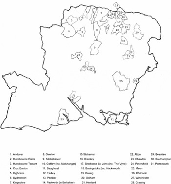
Hampshire Parishes. Settlement names are synonymous with parish names. The three estates in brackets have their seats within the corresponding parish. Padworth is in Berkshire.

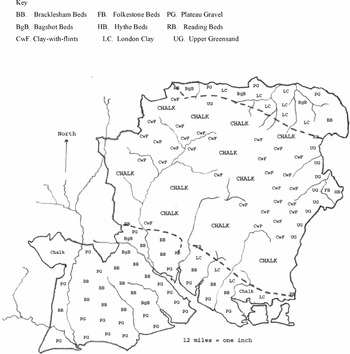
Principal geological deposits. The dotted line of the Reading Beds clay (RB) is the geological divide separating the clays and gravel in the north and south of the county from the central chalk. The clays, gravel, and clay-with-flints support the major woodland areas.

The distribution of woodland in medieval Hampshire was determined by the county's geology. The easily worked chalk soils of the central downlands were used to grow grain and provide natural grass. Interspersed among the chalk are the less easily worked outcrops of clay-with-flints which were used to grow the most used tree species: oak, ash, and beech. Surrounding the downlands are a mixture of soil types, ranging from sand and gravel, greensand, and heavy loam and clay through to fen and gley, on which grow oak, elm, ash, alder, willow and birch. In the late medieval period these less productive soils contained the remnants of the old intercommonable and unenclosed Anglo-Saxon wood pasture system that also formed the core areas of Hampshire's Royal Forests.
Wood pasture
The first Anglo-Saxon settlers in Hampshire brought with them what Kemble referred to as a German tribe's ‘property’ in the ‘settled upon arable, surrounded by forest pastures’.Footnote 8 The ‘property’ was an individual settlement's exclusive rights of common usage over its own cultivated grounds (the common fields) and its shared rights with other settlements to pasture (feed) its livestock and take its wood fuel from the uncleared waste. This was the collective term given to the land that consisted of rough grass, scrub, wood, and timber that lay beyond the cleared and cultivated lands of the settlements. Through continuous use, this waste land was gradually developed into the extensive landscape and communal land use system currently known as wood pasture. It has been suggested that such a system was used in the seventh century by a group of early Saxon settlements in the Micheldever valley, six miles north of Winchester.Footnote 9
A wood pasture landscape is described in detail in the Survey of Pamber Forest made in 1611. It consisted of roughly 1500 acres divided into eighteen plains, each of which had its own coppice of between twenty and forty acres in extent.Footnote 10 This description is similar to the 1791 eyewitness account of the New Forest as tracts of woody country intermixed with patches of pasturage and divided by wide heaths, square or rhomboid-shaped coppices, and thickets of underwood ‘chiefly of the thorny kind’.Footnote 11 These descriptions are close to Vera's modern interpretation of the Domesday term silva as wood pasture: ‘a mosaic of groves and grasslands with trees growing in thorny scrub’.Footnote 12 The pasture element was originally a secondary resource that was largely exploited by the manors for the benefit of their foraging pig herds. Over the centuries, in occupying the same acreage of land year on year, this physical presence eventually gave an individual manor the opportunity to claim, by virtue of long usage, the ownership of the land seasonally occupied by its pigs.Footnote 13 The medieval term for wood pasture was wood ground and the terms for its component parts, as used in the Survey of Pamber Forest made in 1596 and the medieval Crawley records, are coppice, underwood and timber.Footnote 14
Coppice and wood-fuel
The term ‘coppice’ comes from the early English koppis, which is derived from the Old French coupiez or copiez meaning ‘to cut’, but it was also used to describe the management system that was devised to ensure a continuous supply of wood. This took advantage of the ability of most tree species, when cut at any stage up to forty years growth, to produce several new shoots from the cut stool, or stump, which, on a managed rotation, can produce a predictable yield of wood for centuries. This was proved at Bramley Frith, a mile east of Pamber, which is a one hundred acre woodland dating back to at least the mid fourteenth century.Footnote 15 It contains ash stools, measuring from fifteen to thirty feet across that almost certainly date back to that period, if not much earlier. In the 1990s these ancient stools were brought back into rotation after standing uncut for over thirty years.Footnote 16 Bramley Frith proves the claim by J. D. Young that coppiced woodlands resulted in a continual regeneration and not a destruction of woodland.Footnote 17
It is this resilient property of coppice that allowed the woodcutters the flexibility of cutting rods and poles from suitable species at varying ages to suit a particular need, as the following examples illustrate. The earliest documentary evidence of a managed system is from Italy in the first century CE, when Columella recorded that an acre of sweet chestnut should yield 12,000 vine stakes when cut at five year intervals.Footnote 18 In Hampshire, 20,000 vine stakes were produced from one acre of twenty year old coppice at Beaulieu Abbey in 1269 to 1270; in 1762, one acre of coppice cut at twelve years growth produced 2,200 hop poles at Herriard; and in 2002, on the Malshanger Estate five miles west of Basingstoke, an acre of four year old hazel, yielded 10,000 to 15,000 hedging stakes.Footnote 19
Another form of coppicing was the pollarding of trees that were growing on boundary banks and in field hedgerows. Pollards were trees that were managed as aerial coppice, in that the main stem, or trunk, was regularly cut about ten to fifteen feet above the ground. This put the regenerating shoots, which grew a new crop of poles, out of reach of browsing animals. The 315 pollards in a total of 1055 timber trees recorded on a sixty acre farm in Pamber in 1720 underlines their importance in the farm economy.Footnote 20 Their particular use was for making fence pales, posts, and rails. Pollards blur the distinction between coppice and trees. The modern legal definition of timber trees, that they are ‘of the age of twenty years and upwards’, is misleading.Footnote 21 To illustrate this point, a five inch diameter branch cut from a felled 130 year old oak tree on Pamber Forest Farm in 2006 was forty years old, whereas young oak coppice had already grown to nine inch diameter in just twenty years. The real difference is that coppice has several slender stems, or poles, growing from a stool that was cut at near ground level for periods of up to thirty years, whereas a timber tree has one large stem, the trunk, which was usually felled at eighty to one hundred and twenty years old, with no regrowth from the cut stump.
In terms of yield per acre, thirty-four year old poles of up to ten inches diameter yielded 144 tons of wood fuel per acre in Devon in 1941.Footnote 22 For comparison, an acre of twenty large oak trees of eighty years growth will produce between 140 and 160 tons of timber.Footnote 23 Over a period of ninety years, therefore, an acre of oak coppice will produce two and a half times more wood than an acre of mature trees, which is why it was the chief source of wood fuel in north Hampshire. Large quantities of wood fuel were also obtained from the unusable timber that was felled for construction purposes. For example, the main trunk of the abovementioned 130 year old oak measured ten feet six inches long by three feet in diameter and provided approximately one ton of usable construction timber. Above that height, the timber, together with the large limbs and other branch wood, collectively known as the ‘lop and top’, amounted to well over two tons that was only fit for fuel.
A seventeenth-century Hampshire farmer claimed that, ‘Where Woods are raised and maintained, there is a constant Supply of Fewel. . .in every house, as well poor as rich, of good Wood’.Footnote 24 But even where fuel was plentiful, the disparity between the amounts used by rich and poor could be huge. In 1545, Hampton Court Palace managed to get by with 400 faggots and two cords (approximately four tons) of wood for fuel each day throughout the winter, whilst in 1725 a provision was made in a will for a Pamber woman to be given 120 ‘good’ faggots and a load of turf (in all about two tons) for fuel each year.Footnote 25 A more accurate figure for a cottager's family is twenty-five to fifty tons a year. This is based on an estimate, made in 1792, that a cottager's family needed a quarter to half an acre of coppice of twenty years growth per year, or five to ten acres in total, to maintain a constant supply of wood fuel.Footnote 26 The tonnage is almost identical to the thirty-three to fifty-two tons of wood used annually by the households of the eighteenth-century pioneer farmers in America, and in proportion with the yearly average of 153 tons of wood fuel needed by the Herriard Estate over the ten year period from 1684 to 1693.Footnote 27
It is estimated that eighty per cent of the heat generated disappeared up the wide chimneys of the open hearths of the period.Footnote 28 In the twenty-first century this loss has been drastically reduced by using a chimney liner of stainless steel packed around with vermiculite in conjunction with a closed wood-stove. Two such stoves (nine kilowatts and four and a half kilowatts) heat the seven rooms and provide hot water for six months a year in Pamber Forest Farm's nineteenth-century cottage. In mild winters the stoves jointly use six to seven tons of wood from October to April, but if the larger of these had to be used for cooking all the year round, and had to cope with a very hard winter such as that of 1962–3, the consumption rate could more than double. All of the wood fuel comes from Pamber Forest Farm's twenty acres of well wooded land. It is harvested from birch, aspen, and grey poplar, felled at twenty to forty years growth; willow pollards at ten to twenty years growth; ash and oak coppice cut between fifteen to twenty-five years growth; and the overhanging limbs from oak trees of eighty to two hundred years growth. Everything down to one inch diameter is used for fuel. The axe and the crosscut saw that were used for felling timber throughout the medieval period and well into the 1960s, have been replaced by a chainsaw, although a billhook is still used for cutting and trimming the small wood. For haulage, the tractor and trailer have replaced the wagon pulled by horses or oxen. Otherwise, the cutting down, hauling, cutting up and splitting of the wood is the same arduous process as that used by the American pioneer farmers, who expended thirty-nine to fifty-four days a year employed in harvesting their thirty-three to fifty-two tons of annual wood fuel requirement.Footnote 29
Charcoal was the other source of fuel. It is referred to throughout the accounts without giving any details of quantities used or prices paid. It produces an intense heat that makes it suitable for small industrial purposes such as smithery. It takes about seven tons of wood to make one ton of the charcoal.
Underwood, commoners, and customs
In the medieval period, most manorial lands were divided between the arable fields, meadows, pasture (rough grazing), wood ground, and waste (land, such as roadside verges, that was not part of the other categories). The soil of the manor was claimed by the lord but administratively the land was divided between that which was exclusively for the lord's use, and that over which the community had a right of common access and use in order to grow their grain, graze their livestock, or to take their wood fuel. Similarly, the coppice wood and the timber were solely for the lord's use but the inhabitants of the manor were allowed to cut and use the underwood, which was the major source of wood fuel for the majority of a manor's inhabitants. Underwood was literally the wood that grew under the maturing timber and it included bramble, gorse, broom, blackthorn, hazel, hawthorn, and holly. This layer simultaneously supported and protected the oak, ash, or other saplings that were needed to grow on to mature as timber trees. By stipulating where and when the underwood could be taken, and what tree saplings were to be left, the lord was thus able to protect his future timber supplies whilst simultaneously meeting his tenants’ need for fuel.
The means of control used at Crawley was a fine. In the Court Presentments in 1703 it was recorded that ‘it is the custom of our maner. . .to haue the Cut of the Northwood Coopes at five shilling an acker [acre]’. Coopes, a corruption of the French ‘coupe’ or cut, was the allotted acreage of underwood that could be cut for fuel in any one year. The five shillings per acre had been constant throughout the period from 1375–6 to 1448–9, and it was the same price in 1503–4 and in 1755.Footnote 30 Compare this price to the sales of coppice wood at Herriard in 1609, where standing oak coppice was sold for sixteen pounds, thirteen shillings and four pence per acre,Footnote 31 and it appears that the five shillings at Crawley was not a ‘sale’ in the modern sense of the term but a fixed annual payment collectively rendered to the lord by the inhabitants so that they could enter specified areas of his wood ground to cut their fuel. Two customs that were not ‘fined’ were the tenants’ liberty to depasture their sheep within the coppices as long as these were removed by Michaelmas (29th September), and allowing a man to cut and take away from the downland as much scrub for fuel as he could carry on his back.Footnote 32
The Enclosure Act of 1794 finally extinguished the Crawley rights.Footnote 33 Whilst those rights, and their chronology in particular, might be applied to other manors held by the Cathedral, they cannot safely be extended to include the independent lay manors of north Hampshire. At Herriard, for example, 1596 is the last date for evidence of a tenant depasturing his livestock in a coppice, and early eighteenth-century leases from Herriard, and the Hackwood Estate, two miles south of Basingstoke, recite only the right of tenants to take wood fuel from designated coppices, and such timber as was required for the repair of implements, buildings, and fences.Footnote 34
Timber
The principal timber species that were used on the Hampshire manors for building construction and agricultural implement manufacture were oak, ash, and elm. These uses are recorded for the Cathedral manors from the thirteenth to the fifteenth centuries.Footnote 35 In the eighteenth century, Herriard kept a stock of boards and posts, as well as sixty-two different items of agricultural ‘spare parts’, ranging from plough wheels and spokes to waggon sides and tail-ladders.Footnote 36 In 1763 Hackwood felled twenty-five oaks and two elms for repairing a roof, a barn floor and doors, a house floor, gates and a well curb, and twenty-five beech trees for fuel.Footnote 37 Beech was an economically important species favouring the chalk. It does not coppice but was cut at forty years growth for making furniture and treenware (domestic utensils) and used for firewood.
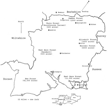
The largest repositories of wood and timber in the county were the Crown's Royal Forests that covered the plains and coppices of the major remnants of the extensive Anglo-Saxon communal wood pasture system. These were centred on Pamber in the north; Hurstbourne Tarrant in the north west; Aliceholt and Woolmer, north east of Alton; Parnholt (West Bere), west of Winchester; East Bere, north of Portsmouth; and the New Forest in the south. In the thirteenth century, oak timber was taken from Pamber for building work on the castles at Windsor and Corfe, and also gifted for repairs to the Priories at Pamber and Chertsey in Surrey, and Godstow in Oxfordshire.Footnote 38 The recorded number of trees taken yearly was less than a hundred. Over the twelve years prior to 1596 the rate of extraction still only averaged 120 young and mature oak trees a year, which included: 304 for work on ‘her majesties house’; five for use on the Royal hunting lodge at Freemantle Park, near Kingsclere; and 234 used for firewood.Footnote 39
The principal areas of Hampshire's Royal Forests in 1600.

Oak coppice wood and oak timber were also the principal source of the bark needed for leather tanning. The coppice in particular, when cut at thirty years, ensured a continuous supply yielding up to twelve tons per acre, and sales of it appear regularly throughout the accounts of the north Hampshire lay estates.Footnote 40 Another by-product of coppice wood and timber was treenware. Given its durability, and the fact that it can be produced from any species, it seems likely that, in a largely self sustaining local economy, treenware was never more than a by-product of wood fuel production. The fifty-three examples retrieved from the wreck of the sixteenth-century Mary Rose are representative of the period and range from boxes, bowls, plates, spoons, and handles, to needles and combs.Footnote 41 Many such objects were produced from beech using treadle operated pole lathes that, to judge from a thirteenth-century illustration, were little different from those still being used commercially in north Hampshire in the 1930s by the Idenden family of Baughurst to produce pharmaceutical pill boxes turned from birch.Footnote 42
Ship's timber
In 1596,168 trees were felled in Pamber for ‘Crosse the Shipwrighte’, and the significance of this event was that it marked the beginning of the end for the forest's medieval wood pasture economy.Footnote 43 The earliest record found for shipbuilding timber taken from north Hampshire is for 1362, when an unspecified quantity was taken from the King's Park at Odiham.Footnote 44 This could have been intended for a galley, the principal fighting ship prior to 1500. The invention of the cannon led to galleys eventually being replaced by Elizabeth I's broadside armed warships, and the increasing size of the guns carried by these vessels also led to an increase in the size of the ships that were built for the Navy. In 1618 there was only one thousand ton ship out of a fleet of thirty.Footnote 45 By 1757, the fleet had increased to 269 ships, of which nearly one hundred were more than that tonnage.Footnote 46 Measured in terms of timber, in the thirteenth century it took forty trees to construct a galley, whereas in 1769 it took two thousand trees to build one seventy-four-gun ship of the line.Footnote 47
The main timber requirement in medieval buildings was for straight posts or beams up to ten inches square, and the post and beam joint that supported the juncture of a wall and ceiling was strengthened by a separate curved piece of timber, known as an arch-brace. There was no shortage of suitable timber for these purposes in England. In the larger warships the posts and beams were up to eighteen inches square but the bracing joint between the side timber and the deck beam was known as the knee. This was a single, solid, piece of timber that weighed a ton or more. It was triangular in shape, with two, four foot long, straight sides, and a curved hypotenuse. The natural grain of the wood, as well as strengthening the decks that carried the guns, also contributed towards the overall solidity and seaworthiness of the ship. Such timber took a long time to grow, and it was the scarcity of trees that were suitable to supply the size and shape of the ‘knees’ required for the bigger ships that appears to have given rise to the perception of a general timber shortage in England. The 130 year old hedgerow oak cut in 2007 on Pamber Forest Farm (see p. 164 above), had a trunk diameter of twenty-eight inches at ten feet from the ground, all but four inches of it solid heartwood. Although suitable for posts, beams, or planking, it contained no timber in its top to produce knees of sufficient size for a seventy-four-gun warship. This is because the tree was growing too close to others of a similar age and size, thus restricting the spread of its side limbs. It was only from the tops of freestanding trees of a similar or greater age, where the side branches had room to grow and develop into large limbs, that ‘the choicest knees’ could be fashioned for use in shipbuilding.Footnote 48
In Hampshire, such trees were only found in any quantity on the forest plains where, in 1608, it was estimated that there were 133,179 loads of ‘fit’ navy timber. Of this, 115,713 loads were in the New Forest, which also contained 118,072 loads of decayed timber.Footnote 49 The latter is an indication that before 1600 the county and the Crown probably had far more timber than they could use. Consequently, there had never been the need for a managed system of replenishment, such as existed with the coppice. Therefore the sudden and ongoing demand for large timber that took over a hundred years to replace meant that by the late eighteenth century there was a shortage of knees ‘on account of the scarcity of timber fit for the purpose’.Footnote 50 Whilst this undoubtedly contributed to the timber stocks in the Hampshire forests having dwindled to 40,812 loads by 1783, other factors were also responsible for the perceived shortages of Navy timber.Footnote 51 Not least of these was the corruption in the Navy's administration, which was rife in the early seventeenth century, and worsened in the eighteenth century.Footnote 52 In 1608, for example, the best Crown timber from Aliceholt and Pamber was being sold to private buyers for building construction and other purposes, whilst the Navy received the poorest, so that the 1,144 loads of timber (four hundred of them from Pamber) that were sent for the repair of three ships at Woolwich and Deptford were insufficient for repairing even one.Footnote 53
The next record for navy timber being taken from the forests of north Hampshire is from Aliceholt in 1776, although there appears to have been no general shortage of wood and timber in the interim period.Footnote 54 In 1611, for example, 230 loads of firewood were taken from Pamber ‘for his majesties [sic] use’; 644 oaks were sold privately from the Sydmonton Estate in 1626; and in 1636 the Crown bought 350 loads of timber from private estates for its own building work.Footnote 55 There is no direct evidence of any shortages following the Civil War. However, given that there were several thousand Parliamentary troops besieging Basing House for periods of up to twenty-four weeks between 1643 and 1645, it seems likely that there must have been some local shortages.Footnote 56 After the War, Herriard claimed £400 as reparation for timber taken from its Estate by the 400 Royalist defenders of Basing House during the hostilities.Footnote 57 A shortage of timber caused by the War could be reflected in its selling price, which at Sydmonton rose from thirteen shillings per tree in 1626, to seventeen shillings in 1683.Footnote 58
Transport
There is little evidence in the manorial records that transportation was the most expensive single item in wood and timber production, because no cost was involved for the owner. It was a service performed by his tenants. In 900 CE, the husbandmen of Hurstbourne had to supply their lord with four cartloads of split wood as part of their dues; in 1280, firewood was delivered from Crawley to Winchester Cathedral as a service; and in 1713 a tenant of Sydmonton manor had to transport twenty loads of log wood to the House each year as part of his farm lease.Footnote 59 With the exception of the Crown, the buyer had to bear the considerable cost of transportation for wood and timber bought from a manor. In the seventeenth century, for example, a load of wood fuel (one hundred faggots) could be bought from Herriard for thirteen shillings but it cost another three shillings and six pence to transport it the five miles to Basingstoke.Footnote 60 The term ‘load’ is imprecise. One hundred faggots, weighing approximately half a ton, constituted a load, as did one oak trunk that was ten feet in length and three feet in diameter and weighed over one ton.
In 1607, transporting Crown timber from north Hampshire overland to Reading and thence, via the Thames, to the royal dockyards at Deptford and Woolwich, cost twenty-seven shillings and six pence. Of this, the Crown contributed seven shillings and six pence and the rest was a charge on the county.Footnote 61 Twenty shillings was nearly double the rate charged for transporting timber locally. In part this arose from the Crown purveyors, who hired the carts needed to transport the timber, procuring far more than were needed and then charging up to thirty shillings a cart to release the surplus back to the cart owners. They, in turn, and aided by the county constables, passed the costs on to the county.Footnote 62 These figures also conceal the hidden cost for the landowners. Because of the poor state of the roads, the timber could only be moved at the driest periods of the year, which was usually in the summer when the manors needed the carts for hauling their own wood and timber, as well as their hay and grain harvest. It was such injustices by the Crown that contributed to the causes of the Civil War.
Fencing and dead-hedges
After fuel, fencing was the greatest consumer of wood. In Domesday Book, entries similar to that listed under the manor of Meon for ‘2 acres of woodland, for fencing’, are frequent in the county's record.Footnote 63 This could indicate woodland to be fenced off, or woodland to be cut and used for fencing. It could also refer to either a ‘pale fence’ or to a ‘dead-hedge’. Both forms required huge quantities of material for their construction. Paling was the most extravagant. In 1530 a total of 24,000 pale posts, shores and rails were used to enclose the King's New Park from the heath at Hampton Court, and in 1604 the cost of felling timber in Pamber Forest and transporting it to Richmond, ‘for paling a park, and building a lodge there’, was £231 or approximately 231 loads.Footnote 64
The dead-hedge was a temporary fence put around the common fields to protect the crops from being damaged or eaten by domestic and wild livestock. These were still in use in the seventeenth century on the Basing Estate, two miles west of Basingstoke, and on The Vyne Estate, three miles to the north. On the former, the fences were constructed on St Andrew's Day (30th November) for wheat, and May Day for barley. These were removed after harvest, when the domestic livestock was allowed in to graze the stubble.Footnote 65 On the latter, the construction consisted of two parallel fences that, for 2,376 yards, took 1000 stakes and 40,000 rods.Footnote 66 Between the fences quantities of bushes and branches were laid, which would have been at the rate of one cart load for every eight and a half yard run of dead-hedge.Footnote 67 At Herriard, and Crux Easton in north west Hampshire, dead-hedges were also used around the coppices to keep the livestock from browsing the new growth of recently cut stools.Footnote 68
In the early eighteenth century, the tenants of Crawley were still expected to maintain the dead-hedges around the common arable fields using the lord's materials and their own labour.Footnote 69 But where the construction was done solely for his benefit it was also paid for by him, either as a rent reduction or as paid labour. For example, on a Hurstbourne Priors manor in 900 CE tenants did the task as part of their ‘dues’.Footnote 70 In 1305–06, the Bishop of Winchester was paying his tenants to maintain the fences around his coppice in the wood ground of his Crawley manor, at the rate of one shilling and fourpence per 220 yards.Footnote 71 The rate for making sixty lugs (330 yards) of hedge on the Beaurepaire Estate, three and a half miles north of Basingstoke, in 1680, was three pence a lug.Footnote 72
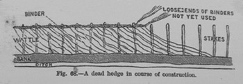
Although the dead-hedge was originally used to protect growing crops against the depredations of livestock, and to limit, in time and space, which land a community could access and use, it was the planting of permanent live quickset (hawthorn) hedges that marked the beginning of the separation of private from public land. Although such hedges were used in Hampshire in the fifteenth century to make small permanent enclosures, such as closes or meadows, it was not until the extensive common field enclosures in the eighteenth century that living hedges wholly replaced the dead-hedges.Footnote 73 Even then, dead-hedges, of the type illustrated in Figure 4, were constructed to protect the newly planted quickset hedges that were used as permanent boundary markers between fields.Footnote 74 For this purpose on the Herriard Estate in 1819, parallel ditches were dug a few feet apart to provide the earth to make a central bank, 321¾ yards long. The ‘quicksets’ were planted along the bank with a dead-hedge, constructed from 5,000 rods, on either side to protect them until they were established.Footnote 75
A dead-hedge under construction.

Enclosure
Early Anglo-Saxon settlement in Hampshire is thought to have begun along the river valleys, with individual community groups, such as those along the Dever valley, each having its own common arable fields and, with other groups, sharing free access to the unsettled and uncleared land beyond the settlements for their grazing, wood-fuel and timber. With the spread of Christianity in Hampshire, the collective settlements of the Dever valley pattern gradually gave way to the parish that contained a nucleated village and a church and, over time, as the population increased and expanded, new settlements were created on the downlands. The unification of the county under Cynegils, and his foundation of the Church of Winchester around 634 CE, brought another major change in the pattern of land holding. The foundation of the Church, which was later to become the Cathedral, included the Chilcomb Grant, a gift of land outside of the city that was intended to provide sustenance for the Church's twenty Benedictine monks.Footnote 76 This provides the first tangible evidence of a new division of land in the county between the Crown, the Church, and the Saxon laity. After 1066, this was further fragmented by the Norman manors, which were not always conterminous with a parish, although they often included a former Saxon church and village but with the addition of a manor house and farm.
Each manor had, within it, its own common fields and commonable woodgrounds. A scaled down layout of the Pamber and New Forest systems formed the basis of the manorial woodgrounds, such as that of Herriard. In 2008, this woodground covered 140 acres, only five acres less than in 1635. It still retains the old name and many of its old boundary banks which, with the presence of long living marker trees, including field maple and box, and rare ground flora, such as Daphne mezereum, provide some physical evidence to suggest that in 1635 this was still wood pasture, and that it was only converted into coppice-with-standards in the eighteenth century.Footnote 77 This also suggests that the Herriard woodgrounds were remnants of the original intercommonable wood pasture system that were isolated and absorbed by the manor as the surrounding land was enclosed, cleared and cultivated.
Other manors, as well as containing their own woodgrounds, also retained their original access to the remaining, and receding, unclaimed and unsettled intercommonable wood pasture areas. The manor of Overton, for example, had one such outlier in Pamber Forest, twelve miles away. This detachment led to transhumance, which was the seasonal migration of a manor's livestock, specifically pigs, to occupy the same area of wood pasture each year.Footnote 78 This subsequently led to its surreptitious enclosure and claim of ownership. The three parts of the process were eventually codified as Possession; Adverseness of Possession, i.e., ‘a holding not permissive or subordinate but exclusive against the world’; and Prescription, i.e., ‘a period of time during which the Adverse Possession has uninterruptedly continued’.Footnote 79 These prescriptive common rights descended with the manor and not with its holder or owner, as did any subsequent enclosures of land that were claimed. In Pamber the claimants were known as the Free Franchisers.Footnote 80
By 1600, about 500 acres of the loamier southern plains of Pamber had been enclosed and divided into small fields, leaving about another 1500 acres of the plains unenclosed.Footnote 81 The first full attempt to enclose this remainder was made by the fourth Marquis of Winchester, hereditary Keeper and Governor of the Forest, who tried to purchase the plains from the Crown in 1614.Footnote 82 His intention was to divide the land into ‘quillets’, or crofts, and sell them on, but his scheme was opposed in a petition to James I that was signed by 300 people from surrounding parishes, who were led by John Littlefield. He owned Padworth, one of the manors that in the past had enclosed land from the plains and claimed prescriptive common rights over the remainder.Footnote 83 Littlefield's petition was successful but by the end of the seventeenth century another 500 acres had been enclosed, some of them possibly through purchases from the Commonwealth Government after the end of the Civil War.Footnote 84
In the eighteenth century many manorial commons were being enclosed either by agreement with other commoners or by Private Acts of Enclosure. These were lengthy and costly processes, as witness the fortunes of the owner of the Oakley Hall Estate. In 1742, Henrietta Worsley wished to enclose the Oakley commons by agreement with the other four freeholders but one ‘in crossness sticks out’ against it, possibly being content with the old customary economy. Without this person's agreement the enclosure could only proceed by passing a private bill in Parliament, which would have been ‘a great expense’ and, in any case, she had ‘not any friends in the House’. The enclosure finally took place by agreement in 1773.Footnote 85 By inheritance, Henrietta also owned the Wyeford Estate in Pamber which, because it had previously formed part of the lands that had been prescriptively enclosed from Pamber Forest by Winchester Cathedral in 909 CE, allowed her to claim the manor's right of common over the forest.Footnote 86
Along with other Free Franchisers, who included the owner of the Padworth Estate, she continued to contest the unofficial enclosure of the remaining 1000 acres of forest plains that had been made in 1720.Footnote 87 The encloser was another Franchiser, Anne Wrighte, who was the great granddaughter of the unsuccessful fourth Marquis of Winchester. The advantages that Wrighte had over her rivals were friends at Court; inherited wealth; and hereditary office over Pamber Forest.Footnote 88 As it was, her opponents could only frustrate her attempt by successfully protecting their prescriptive common rights. Agreement was reached whereby one plain, Frame Green, was left open to allow the Franchisers to exercise their common rights.Footnote 89 The purpose of the Pamber Enclosure Act of 1824 was to extinguish the Franchisers’ common rights over the forest, as well as to enclose Frame Green. In lieu, the Franchisers received allotments from what little land remained to be enclosed in Pamber. More importantly, the Act finally gave them legal freehold title to the lands that they already held in Pamber through the prescriptive enclosures they had made over the centuries.Footnote 90
The unofficial enclosure plan drawn up for Anne Wrighte in Pamber in 1720 was designed to convert the land from its extensive wood pasture use into intensively managed woodland. The former plains and their oak and alder coppices were to be replaced by twelve large coppices, each of between fifty to one hundred acres, in which nursery raised oak saplings were planted for the timber. For its protection, this was interplanted with hazel, for fuel, and sweet chestnut, for poles, as the coppice/underwood. This is the system now more commonly known as coppice-with-standards. The underwood was to be cut on a twelve year rotation, to allow the thinning of the timber saplings, and to prevent the best from being smothered.Footnote 91 Also in the eighteenth century, manorial commons such as Sydmonton (1700 oak trees), and Herriard (4442 ash, oak and beech), were also being enclosed and planted in a similar way and for the same purpose.Footnote 92 Timber was the principal crop, planted to meet the increasing demands from the Navy. The underwood could be sold to the hop market for poles and fuel. However, the gradual replacement of wooden ships by iron-clads from the 1860s onwards, caused a rapid market decline for timber that took a century to mature. Fortunately for the landowners, the market from the hop industry for the underplanted coppice wood proved far more profitable; hence the saying in north Hampshire that ‘the underwood [coppice] will buy the horse, the wood [timber] will buy the saddle’.Footnote 93 The enclosures also included hundreds of acres of Crown heathland that were converted into conifer plantations, causing Cobbett to complain that north Hampshire ‘contains not one plantation of oaks! Plenty of fir trees and other rubbish have been recently planted but no oaks’.Footnote 94
Coppice Products and Markets
The Tudor period saw a revival in hop growing, and its success was such that, by the mid-seventeenth century, an acre of hops was deemed more profitable than fifty acres of arable.Footnote 95 A three acre field enclosed from part of Bentley Green plain in Pamber Forest in 1653 was just one of many created across north Hampshire for growing hops.Footnote 96 This field has a southerly aspect, a medium loam, and good drainage that, with liberal dressings of dung, were the prerequisites for successful hop growing. Initially, an acre of hop bines needed about 3000 poles for support, a quarter of which needed replacing each year.Footnote 97 Added to this was wood fuel needed to dry the hops. The preferred fuel was charcoal, a ton of which was produced from seven tons of wood but actual consumption figures for drying one acre of hops are difficult to find.Footnote 98 The yield of good poles could vary from 850 to 3300 per acre of coppice, and the waste from this contributed towards the fuel required for drying the hops.Footnote 99 Thus, cut on a rotation of twelve to fifteen years, each acre of established hops needed at least twelve to fifteen acres of coppice to sustain it in poles and fuel.Footnote 100 Initially, the existing coppices of alder were used. In the thirteenth century alder poles from the Pamber Forest's coppices were used for scaffolding on the Lodge at Freemantle Park, so they were well suited as hop poles, until they were replaced by sweet chestnut.Footnote 101
In the early 1830s the hop industry across north Hampshire was in rapid decline but other markets opened up for wood products that compensated for its loss. The construction of the Basingstoke Canal (1794), and the Kennet and Avon Canal (1810), followed by the Great Western Railway (1835), and the London and Southampton Railway (1838), put the north Hampshire woodlands within reach of the expanding or new markets opened up across the country by the Napoleonic Wars and the ongoing Industrial Revolution. From October to June each year the woodlands resounded to the woodcutters felling, cutting, trimming, sorting, and carting away, the rods and poles of varying thicknesses and lengths that were fashioned into a number of products. These included barrel hoops, crate rods, hurdles, handles, thatching spars, and besom brooms. Crate rods and besom brooms were sent to the Midlands. The rods were used by the potteries to manufacture packing cases for exporting porcelain, and the brooms were used in the iron foundries to remove the scale that formed as the molten metal made contact with the cold air. Bavins were used by the thousands to fuel the brick kilns and, in 1863 alone, 18,455 were sold by one wood dealer to an independent Pamber brick maker.Footnote 102 Using their own clay and wood fuel, the estates also made bricks for use in improving their own buildings, and tiles for land drainage. Bricks were also made and sold for the construction of tunnels and revetments for the railways and canals.
By the 1870s the whole coppice industry was in slow decline. Iron bands replaced the wooden barrel hoops, and wooden utensils were increasingly replaced by china pottery. In the 1950s, some crate rods were still produced, as were pit props for the coalmines and besom brooms for the smelting industry, but demand was dwindling. Production was finally brought to an end during the severe winter of 1962–3. The steady decline in sheep numbers also greatly reduced hurdle production, although the Herriard Estate continued to sell some coppice for these until the early 1970s.Footnote 103 For a brief period, from 1985 to 2006, a demand for large hurdles for use as garden wind breaks encouraged Hampshire County Council to attempt the revival of coppicing in Hampshire, with the added objective of conserving the flora and fauna associated with coppiced woodland. The initiative failed because it was a fad market that could not be sustained, particularly when faced with the increasingly cheap imports of hurdles from Poland. In 2008, all that remained was the Malshanger Estate still selling one acre of pure hazel coppice a year for hedging stakes, and a part-time hurdle-maker working at Lasham, and another at Up Somborne. A small demand has remained for domestic logs for those dwellings that still have a hearth and chimney, and the recent rise in gas and oil prices has led to an increase in that demand. It is supplied by those private owners who continue to fell timber from their woodlands in furtherance of management plans drawn up for game shooting and nature conservation.
Conclusion
For over a thousand years until 1600, the wood pasture system of north Hampshire made its contribution to the region's economy by producing the wood and timber required to supply the population with its daily requirements for wood fuel, and the material for much of its tools, utensils, and building. A survey of landholdings in north west Hampshire in 1575 shows that most of them contained from one to twenty acres of coppice, and in 1596 even the Crown's coppices in Pamber Forest were being ‘well preserved and kept’.Footnote 104 Pamber was also reported to be ‘full of trees’ in 1586, and was still well stocked in 1596.Footnote 105 The combination of these well managed fuel supplies and the hitherto low demand made on an abundant timber reserve meant that north Hampshire was well placed to supply the increase in demand for wood and timber that was a necessary component of ensuring the success of the Industrial Revolution and the Napoleonic Wars.
The investment needed to increase as well as replenish these stocks coincided with the first coal being brought into north Hampshire in 1692, and the abundance of wood meant that coal never wholly replaced it as a fuel. Consequently, the region does not appear to have suffered the timber and wood fuel shortages that historians have identified in much of England in the sixteenth and seventeenth centuries.Footnote 106 This is reflected in the prices. The rise in the price of a load of timber from thirteen shillings and four pence in 1596, to one pound and eight shillings in 1776, was probably caused by the increasing demand from the Navy. Over the same period the cost of 100 faggots, the basic unit of wood fuel, rose less steeply, from eight shillings in 1604 to thirteen shillings in 1779, suggesting that it was more likely to have been caused by general price inflation rather than by a shortage.Footnote 107 It is also worth noting that any perceived shortages of wood fuel deduced from records of nineteenth-century wood stealing in north Hampshire are also misleading because many of these thefts were perpetrated by people reacting to the loss of their common rights.Footnote 108
The huge increases in the production of wood and timber from 1700 were brought about by intensified use, not the extension, of the existing acreage, through the enclosure of the manorial and Crown common lands. For many agricultural labourers the loss of these commons was more than compensated for by the assurance of winter work in the woodlands, and the opportunity for some to acquire a little capital and land as coppice dealers. For estate owners such as Anne Wrighte, the investment was high but so were the returns. She had been advised that from her enclosure of the Pamber Forest plains she could expect two shillings and sixpence per acre annually from grazing rentals but if she planted wood and timber this could rise to ten shillings. Between 1756 and 1792 the actual return was fifteen shillings.Footnote 109 The returns from Herriard were even higher. Between 1800 and 1847, the average annual income from the average of forty-seven acres of coppice sold there each year, was £528. This was a yearly return of seventeen shillings per acre. Over the same period the sales of timber averaged only £304 per year.Footnote 110 The profitability of the woodlands in the early nineteenth century was such that, in 1833, not only was The Vyne Estate able to use its own timber to improve its buildings, and its own wood to fire its brick and tile kilns, but the surplus sales also contributed £3032 5 shillings 10 pence towards the £3450 15 shillings 7 pence spent on improving the entire estate.Footnote 111
Similar evidence led J. D. Young to conclude that the farming of the woodlands in southern England was as much a part of the agrarian economy as the production of food.Footnote 112 But contemporary evidence from the landowners’ own accounts suggests that, at least from 1600, trees were regarded as capital set aside for a rainy day rather than to meet any wider economic demand. In 1617, part of Sir Henry Kingsmill's legacy from his father was the ‘wood intended you towards defrayinge of deptes and legacyes’, a purpose that was later echoed by another north Hampshire landowner, the Earl of Carnarvon, who described woods as an excrescence sent by God for payment of debts.Footnote 113 If this seems extreme, consider that it was only the Marquess of Ailesbury's sudden death at the age of thirty-one, in 1894, that prevented him from felling Savernake Forest to recoup some of the fortune he had lost in gambling.Footnote 114 Any doubts that trees were a financial and not an aesthetic investment can be dispelled by Jane Austen's friend, Mr Tilson, who admired the trees in Chawton Park in Hampshire ‘very much, but grieved that they should not be turned into money’.Footnote 115