INTRODUCTION
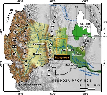
The common occurrence of lakes in intermountain basins results from the interaction of climate and tectonics (e.g., Burbank, Reference Burbank1983). Thus, the sedimentary infill of lakes contains important information about the climatic and tectonic evolution of an area (García-Castellanos, Reference Garcia-Castellanos2006). Understanding the long-term evolution of lacustrine basins is crucial to characterize the processes that shape Earth’s surface. Most lacustrine basins are related to impoundment of paleodrainage systems because of tectonic subsidence or uplift (e.g., Ollier, Reference Ollier1981). A relatively slow tectonic subsidence/uplift can have a great effect in drainage systems (e.g., Kowalewska and Cohen, Reference Kowalewska and Cohen1998; May et al., Reference May, Hartley, Stuart and Chong1999; Sáez et al., Reference Sáez, Cabrera, Jensen and Chong1999). The Mar Chiquita Lake, located in Argentina’s Pampean plains, in northeast Córdoba Province (Fig. 1a), is a conspicuous example of this phenomenon (Mon and Gutiérrez, Reference Mon and Gutiérrez2009). Climate may also be responsible for impoundment and lake development because it controls denudation rates and sediment supply within a basin. Colombo et al. (Reference Colombo, Busquets, Ramos, Vergés and Ragona2000, Reference Colombo, Busquets, Sole de Porta, Limarino, Heredia, Rodríguez-Fernández and Alvarez-Marron2009) described and analyzed terrace levels within alluvial fans related to tributaries of the San Juan and Jáchal rivers in the Precordillera (Fig. 2). They concluded that shallow temporary lakes were the result of slow-growing episodes of alluvial fans that obstructed the Jáchal and San Juan river valleys during late Quaternary. In the case of the Jáchal River, Colombo et al. (Reference Colombo, Busquets, Sole de Porta, Limarino, Heredia, Rodríguez-Fernández and Alvarez-Marron2009) discarded a tectonic origin for the lakes because of the lack of soft deformational sedimentary structures (seismites), slumps, and other neotectonic structures (faults and folds) within the lacustrine sequences.
(color online) (a) Location of the Ullum-Zonda and Tulum valleys within Argentina and San Juan Province. (b) Map of the western border of South America showing the main geologic provinces and the flat-slab subduction segment of the Nazca plate between 28°S and 33°S latitude based on Cahill and Isacks (Reference Cahill and Isacks1992) (compare with the Benioff geometry proposed by Pardo et al. [Reference Pardo, Comte and Monfret2002] and Alvarado et al. [Reference Alvarado, Beck, Zandt, Araujo and Triep2005a, Reference Alvarado, Castro De Machuca and Beck2005b]); main basement uplifts of Sierras Pampeanas (Jordan et al. Reference Jordan, Allmendinger, Damanti and Drake1989) and location of the Precordillera fold and thrust belt (Ramos et al., Reference Ramos, Cristallini and Pérez2002). Modified from Ramos and Folguera (Reference Ramos and Folguera2009).

(color online) The San Juan River basin.

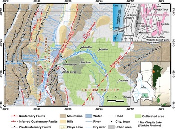
The Ullum-Zonda valley, which is located in the Precordillera of the central Andes, is a tectonic depression with several late Quaternary lacustrine deposits resulting from natural damming of the San Juan River (Fig. 1a). In this work, we use the expression “Paleolake Ullum-Zonda” to refer to the lacustrine and/or palustrine episode(s) and its (their) deposits that occurred in the Ullum-Zonda valley during the late Pleistocene to middle Holocene. These lacustrine deposits have been included in the lithostratigraphic unit that Pandolfo (Reference Pandolfo1975) called the Valentín Formation. This work aims to provide a new insight into the geomorphic evolution of the Ullum-Zonda valley during the late Quaternary, focusing especially on the development of Paleolake Ullum-Zonda to provide new data about past climatic conditions and tectonic events in the central Andes Precordillera.
METHODOLOGY
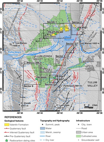
In this work, we analyze topographic, geologic, stratigraphic, geomorphic, and geochronological data. We used GPS mapping, topographic maps, Digital Elevation Models (DEMs), and stereographic aerial photograph interpretation to determine main geomorphic and morphotectonic features. Geologic maps and sedimentary logs from wells across the valley were used to survey the extent of the Valentín Formation. Schematic stratigraphic logs were constructed in the field to characterize Valentín Formation deposits. Six samples were taken for radiocarbon dating with conventional and accelerator mass spectrometry (AMS) methods. Several DEMs were processed with the geographic information system (GIS) software SAGA GIS (System for Automated Geoscientific Analyses) and QGIS (Quantum GIS) to construct paleogeographic models. To gain a better understanding of the study area, we divided it into six sectors, numbered clockwise. To make this division, we took into account the spatial distribution and characteristics of the main outcrops of the Valentín Formation.
GEOLOGIC SETTING
The structural setting of the Andes between 28°S and 33°S is a consequence of the oblique convergence of the Nazca and South American plates and the flat-slab subduction of the Juan Fernández Ridge (Fig. 1b) (e.g., Pilger, Reference Pilger1981; Anderson et al., Reference Anderson, Alvarado, Zandt and Beck2007). The Precordillera comprises a fold and thrust belt located east of the Andes Cordillera, between 28°37′S and 33°05′S, composed mainly of Paleozoic sedimentary rocks. The region was divided into Occidental, Central, and Oriental on the basis of lithology, structure, age, and tectonic setting (e.g., Heim, Reference Heim1952; Baldis and Chebli, Reference Baldis and Chebli1969; Ortiz and Zambrano, Reference Ortiz and Zambrano1981).
The Precordillera Central has been described as an east-verging thin-skinned fold and thrust belt with a décollement within Eopaleozoic strata, whereas the Precordillera Oriental is characterized as a west-verging thick-skinned fold and thrust belt with a deeper décollement in basement crystalline rocks (e.g., Rolleri, Reference Rolleri1969; Ramos, Reference Ramos1988). The interaction between these two opposite verging systems resulted in a north–south tectonic corridor that extends throughout the entire Precordillera. This corridor is called the Matagusanos-Maradona-Acequión (Perucca, Reference Perucca1990; Perucca and Onorato, Reference Perucca and Onorato2011; Perucca et al. Reference Perucca and Onorato2012b, Reference Perucca, Audemard, Pantano, Vargas, Avila, Onorato, Lara and Esper2013; Audemard et al. Reference Audemard, Perucca, Pantano, Avila, Onorato, Vargas, Alvarado and Viete2016).
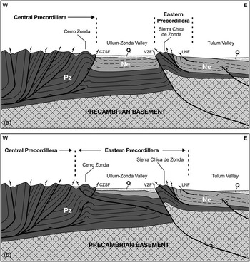
The Ullum-Zonda valley is located within the Matagusanos-Maradona-Acequión tectonic corridor and has an area of 320 km2 with an average altitude of 800 m above sea level (m asl). The deep structure of this valley in a west–east cross section has been interpreted to form a thick-skinned triangular zone (Fig. 3a) (e.g., Zapata and Allmendinger, Reference Zapata and Allmendinger1996; Alonso et al., Reference Alonso, Rodríguez Fernández, García-Sansegundo, Heredia, Farias and Gallastegui2005). However, other interpretations (e.g., Von Gosen, Reference Von Gosen1992; Paredes and Perucca, Reference Paredes and Perucca2000; Siame et al., Reference Siame, Bellier, Sebrier, Bourlès, Leturmy, Perez and Araujo2002, Reference Siame, Bellier, Sebrier and Araujo2005) suggest that this triangular zone is located westward into the Albarracín River valley and between the Lomitas de Matagusanos and Sierra de la Deheza, within the eastern Precordillera Central piedmont (Fig. 3b).
(a) West (W) to east (E) schematic structural profile of the thick-skinned triangular zone hypothesis for the Ullum-Zonda tectonic depression (modified from Siame et al., Reference Siame, Bellier, Sebrier and Araujo2005). (b) W–E schematic structural profile of the west verging valley hypothesis for the Ullum-Zonda tectonic depression (modified from Von Gosen, Reference Von Gosen1992). CZSF, Cerro Zonda Sur Fault; LNF, Loma Negra Fault; Ne, Neogene; Pz, Paleozoic; VZF, Villicum-Zonda Fault.

NEOTECTONIC SETTING
Between 29°S and 33°S, the Nazca plate is being subducted beneath the South American plate at a rate of 6.3 cm/yr (Kendrick et al., Reference Kendrick, Bevis, Smalley, Brooks, Vargas, Lauria and Fortes2003). The flat geometry of the subducted slab may derive from the oblique subduction of the Juan Fernández Ridge underneath the South American plate (Pilger, Reference Pilger1981). This led to the eastward migration of the orogenic front, the absence of current volcanism, high intraplate seismicity, and extensive evidence of Quaternary tectonic activity, mainly in the orogenic front located in the eastern piedmont of the Precordillera (Jordan et al., Reference Jordan, Allmendinger, Damanti and Drake1993; Kay and Mpodozis, Reference Kay and Mpodozis2002).
The La Laja Fault System is associated with the 1944 earthquake (M s 7.0) that destroyed the city of San Juan (Alvarado and Beck, Reference Alvarado and Beck2006). Other noteworthy fault systems include the Villicum-Zonda, Tulum, and Cerro Zonda Faults (Bastías, Reference Bastías1986). The Sierra Pie de Palo was also the epicenter of the 1977 earthquake (M s 7.4) that destroyed the nearby city of Caucete (Fig. 1a) (Instituto Nacional de Prevención Sísmica, 1993).
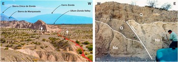
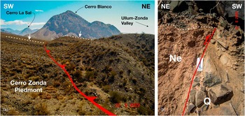
The 145-km-long Villicum-Zonda Fault System is located on the eastern border of the Ullum-Zonda valley comprising a series of west-verging reverse faults and trends north-northeast throughout the western flank of Precordillera Oriental (Bastías, Reference Bastías1986). A segmentation in the age and magnitude of the tectonic deformation can be observed along this fault system. This segmentation seems to be controlled by northwest, southwest, and east–west crustal structures that influence the tectonic and magmatic development of the Andean orogen (e.g., Baldis et al., Reference Baldis, Uliarte and Vaca1979; Siame et al., Reference Siame, Bellier, Sebrier, Bourlès, Leturmy, Perez and Araujo2002, Reference Siame, Bellier, Sebrier and Araujo2005; Oriolo et al., Reference Oriolo, Cristallini, Japas and Yagupsky2015). In the north of the Loma de las Tapias, this fault places Neogene east-dipping strata over Holocene alluvial deposits forming an eroded west-facing fault scarp (Fig. 4; Perucca and Vargas, Reference Perucca and Vargas2014). Siame et al. (Reference Siame, Bellier, Sebrier, Bourlès, Leturmy, Perez and Araujo2002) estimated a mean uplift rate based on 10Be dating of faulted alluvial fans of 0.7 mm/yr for this segment. In the Marquesado and Chica de Zonda sections, Holocene activity is less evident. However, the western piedmont of southern Sierra Chica de Zonda reveals east-dipping reverse faults with west-facing scarps, growth strata, and an anomalous dip in Quaternary alluvial deposits (Perucca et al., Reference Perucca and Onorato2012b).
(color online) Views of the Villicum-Zonda Fault in the northern Loma de las Tapias segment. (a) Inverse fault scarp facing west (W) disrupting a Quaternary pediment level. (b) Natural trench where Neogene (Ne) can be seen overriding Quaternary (Q) alluvial deposits (photo by Nicolás Vargas). E, east; W, west.

The Cerro Zonda Sur and Cerro Zonda Norte Fault Zones are located southwest of the Ullum-Zonda valley (sector 6, Fig. 5). The north–south trending Cerro Zonda Sur Fault Zone is 10 km long and is characterized by east-verging reverse faults with relatively smooth east-facing scarps, where Devonian sandstones overlay Pleistocene alluvial fan deposits. Springs are quite common along this fault trace. To the north, the Cerro Zonda Norte Fault becomes northwest trending and is characterized by west-verging reverse faults with several southwest-facing scarps where Miocene strata overlay Pleistocene alluvial fan deposits (Fig. 6; Perucca et al., Reference Perucca and Onorato2012b).
(color online) Outcrops of the sectors, Valentín Formation, radiocarbon dating sites, and groundwater wells analyzed in this study.

(color online) Views of the Cerro Zonda Norte Fault. (a) Inverse fault scarp facing west (W) disrupting a Quaternary alluvial fan. (b) Natural trench where Neogene (Ne) can be seen overriding Quaternary (Q) alluvial deposits (photos by Nicolás Vargas). NE, northeast; SW, southwest.

GEOMORPHOLOGY
Mountain ranges in the Precordillera fold and thrust belt are predominantly north–south trending. They show an asymmetrical cross-section profile with straighter and steeper slopes along their faulted flanks. The present pattern of the morphotectonic units in this area derives from Neogene and Quaternary reverse faulting. On the other hand, valleys are characterized by relatively large piedmonts and alluvial plains.
Except for Loma de las Tapias and Loma de Ullum, which are low hills formed by Miocene synorogenic strata, the ranges of Precordillera Oriental are largely made up of Eopaleozoic limestones (Figs. 1a and 5). Altitudes range from 970 m asl (at Loma de las Tapias) to 1754 m asl (at Las Lajas peak, in Sierra Chica de Zonda). Devonian sandstones outcrop to the west in the Cerro Zonda, Miocene andesitic-dacitic rocks outcrop in the Cerro La Sal and Cerro Los Baños, and Eopaleozoic limestones and Devonian sandstones outcrop in the Sierra de La Deheza. Lomitas de Matagusanos, which is located eastward from Sierra de La Deheza, is made up of Miocene synorogenic strata and pyroclastic deposits. Altitudes range from less than 1700 m asl in Lomitas de Matagusanos to 2041 m asl in Cerro Zonda (Figs. 1a and 5).
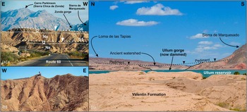
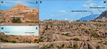
Terraced alluvial fans and pediments are the main piedmont landforms within the study area and are often affected by Quaternary faults. Pediments develop mainly over Miocene soft rocks surrounding Paleozoic-cored mountain ranges. Badlands are a common feature in heavily eroded pediments, with the development of a dense drainage network, a popcorn texture, and piping processes because of the presence of swelling clays (Fig. 7a and b).
(color online) (a) View of two consecutive pedimentation levels (G6 and G5) in Loma de las Tapias. A thin cap of Quaternary (Q) alluvial deposits lies above Neogene (Ne) east (E)–dipping strata. (b) Typical badland landscape of streams and gullies in Loma de las Tapias. (c) Ancient watershed between Ullum-Zonda and Tulum valleys prior to the formation of the Ullum gorge. N, north; S, south; W, west.

The annual rainfall rate is 120 mm/yr, most of which occurs in the summer months during frontal and/or convective storms that can produce torrential rains. In winter, light rain and occasional snow occur in the higher mountain areas. Because of the arid climate, local rivers remain dry most of the year and native vegetation is very scarce. The drainage network is relatively well developed within mountain and piedmont areas. However, the floodplains in the lower areas have suffered severe anthropic modifications, especially regarding land use (agriculture, residential areas, and tourism).
Local base-level changes seem to be controlled by a complex interaction between tectonics, local climate, and the discharge regime of the antecedent San Juan River that orthogonally crosses the main tectonic structures of the Precordillera (Colombo et al., Reference Colombo, Busquets, Ramos, Vergés and Ragona2000). This river is a permanent stream that runs from Cordillera Frontal—situated 200 km to the west—to the Guanacache wetland system in the eastern plains of the provinces of San Juan and Mendoza (Fig. 2). The San Juan River has a glacial-nival regime with an annual mean discharge of 65 m3/s (Departamento de Hidraulica, Ministerio de Infraestructura, Gobierno de San Juan, Argentina; http://www.hidraulica.sanjuan.gov.ar/datos%20y%20estadisticas/km43.html [accessed July 8, 2017]). Its maximum discharge peak occurs during summer (between December and January), and millennial flooding events can reach more than 1000 m3/s (Perucca and Esper, 2009). San Juan River deposits cover a large portion of the Ullum-Zonda valley floor. The San Juan River alluvial megafan located in the Ullum-Zonda valley has an area of 107 km2 with a rectilinear longitudinal profile and a mean gradient of 0.75%. According to groundwater surveys, the estimated thickness of Quaternary deposits is 1200 m. There are no available records evidencing deeper drilling to reach the bottom (Rodríguez et al., Reference Rodríguez, Fiorenza, Damiani and Zambrano2002; O. Damiani, unpublished).
The nearby Tulum valley (Fig. 1a), which is located east of Precordillera Oriental, is a tectonic depression characterized by thick Cenozoic sedimentary deposits. During the late Pleistocene, and probably up to the early Holocene, the San Juan River flowed through the Zonda gorge. From the middle to late Holocene, the San Juan River has flowed through the Ullum gorge, which is located 11 km farther north (Fig. 1a) (Groeber and Tapia, Reference Groeber and Tapia1926). The San Juan River alluvial megafan in the Tulum valley formed during the late Pleistocene and has been abandoned since the middle Holocene. This megafan is 300 km2 and 6.5 km long, and its apex is within the Zonda gorge. This megafan presents three downstream convergent terrace levels with a mean gradient of 0.64% in the lowermost and more recent level and 0.94% in the oldest and uppermost terraces. According to groundwater surveys, Quaternary deposits have an estimated thickness of 800 m (Suvires, Reference Suvires2014).
PALEOLAKE ULLUM-ZONDA
Groeber and Tapia (Reference Groeber and Tapia1926) were the first to describe lacustrine deposits in this valley (sands, silts, and clays). These authors interpreted those sequences as the remains of an ancient lake that encompassed most of the Ullum-Zonda valley. They proposed that differential uplift of the Sierra de Marquesado and Sierra Chica de Zonda during the Pliocene-Pleistocene was responsible for damming the San Juan River. Based on several terrace levels identified in the Loma de las Tapias western piedmont next to the Ullum gorge, Groeber and Tapia (Reference Groeber and Tapia1926) recognized at least four uplifting pulses separated by periods of tectonic quiescence during the late Quaternary (Fig. 7a and c).
Pandolfo (Reference Pandolfo1975) gave the lacustrine deposits the stratigraphic nomenclature of Valentín Formation, without defining a stratotype. She proposed an early Holocene age on the basis of archaeological and paleontological data.
Salinas (Reference Salinas1979) undertook the first sedimentologic study of the Valentín Formation. She identified quartz and feldspar (mainly labradorite) as the main components of sands and silts, and micas, lithic fragments, opaque minerals, and tourmaline as accessory minerals. Apatite and pyroxene are also identified as accidental constituents. Fine planar stratification with beds 1–15 cm thick and scarce evidence of benthic organism activity led Salinas (Reference Salinas1979) to conclude this was a calm and relatively undisturbed depositional environment. She described sediment texture as submature and most of its components derived from reworked sedimentary rocks. The distribution of particle size was bimodal and less often unimodal and multimodal. There was one peak in very fine silts and another one in very fine sands. Salinas (Reference Salinas1979) mentioned this could be interpreted as an indicator of the coexistence of fluvial and eolian sedimentary inputs. Laboratory analyses with sulfuric acid show the presence of synsedimentary metal sulfide and iron oxide. This finding indicates environmental conditions shifted from slightly reducing to oxidizing conditions. X-ray analyses reveal clays are mostly made up of chlorite, illite, and kaolinite (in a lower proportion). This indicates that synsedimentary pH conditions were mainly alkaline with minor intervals of slightly acid conditions in a freshwater body.
García (Reference García1996) describes the presence of Charophyta, Ostracoda, Gastropoda and Percichthys in the Valentín Formation. The thin skeletal structures and the well-preserved state of these fragile fossils led this author to conclude this was a calm and relatively deep, cold freshwater to subsaline environment with neutral to alkaline pH. The species described include the girogonites Chara cf. hispida var. major (Hartman) Wood and Chara cf. papillosa, which are associated with the ostracods Cypridopsis sp., Darwinula sp., Eucypris sp., Chlamidotheca incisa (Clauss) Brehm, and Lymnocythere nov. sp.
Based on archaeological evidence obtained from unpublished reports, Colombo et al. (Reference Colombo, Busquets, Ramos, Vergés and Ragona2000) propose the existence of a great natural lake in the Ullum-Zonda valley originating approximately 6500 yr BP. Contrary to Groeber and Tapia (Reference Groeber and Tapia1926), Colombo et al. (Reference Colombo, Busquets, Ramos, Vergés and Ragona2000) consider that the progradation of tributary alluvial fans in the San Juan River valley was responsible for natural damming of the San Juan River. This would be attributable to the climate shifting toward more humid conditions during the middle Holocene.
Suvires and Gamboa (Reference Suvires and Gamboa2011) obtained the first radiocarbon ages (14C) for Valentín Formation deposits. Their results yield late Holocene ages of 2760±80 (3060–2718 cal yr BP at 2σ) and 1890±80 14C yr BP (1934–1586 cal yr BP at 2σ) for samples obtained within sectors 4 and 6 (Fig. 5). On the basis of these data, Suvires and Gamboa (Reference Suvires and Gamboa2011) propose the existence of one or maybe several small lakes surrounded by wetlands in the Ullum-Zonda valley during the late Holocene. They also state that these lakes and wetlands may derive from warmer climatic conditions in the Andean Cordillera, resulting in an increase of San Juan River’s discharge, and a local base-level rise because of tectonic uplift in the Precordillera Oriental.
According to Blanc (Reference Blanc2014), the formation of lakes in the Ullum-Zonda valley may derive from cyclic shifts between underfilled/overfilled basin stages during the late Pleistocene to Holocene. These stages depended largely on the aggradation/subsidence balance. Blanc (Reference Blanc2014) also concludes that fluvial capture of the San Juan River by the Ullum gorge could have occurred shortly after the end of the middle Holocene (Fig. 7c).
RESULTS
Analysis of the Valentín Formation outcrops
Pandolfo (Reference Pandolfo1975) chose the name Valentín Formation to refer to the fine deposits located in the valley of Ullum-Zonda. Cuerda et al. (1983) established the thickness of the unit in about 30 m. The outcrops of this formation cover an area of at least 200 km2, mainly in the north and south portions of the alluvial fan of the San Juan River. As mentioned before, we divided these outcrops into six sectors, which are described subsequently.
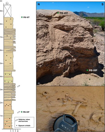
In sector 1, deposits are spread across an area of 5.7 km2. These deposits are mostly planar-bedded white-brownish silts and sandy silts and slightly white-greenish clayey silts with fine to mid-sized sand layers with massive or trough cross stratification (Fig. 8). Gypsum crystals and veins usually fill small cracks, and some silty beds show a blocky texture, probably because of the development of incipient paleosols. Some layers present well-preserved fossil traces (galleries, tubes, and burrows) consisting of sand-filled pipes coated with a thin clay cap (Fig. 8c). AMS radiocarbon dating from a sample of the lowermost exposed level of this sequence yielded a late Pleistocene age of 13,790±50 14C yr BP (16,770–16,440 cal yr BP at 2σ) (Table 1). The topmost level yielded a late Pleistocene age of 12,790±40 14C yr BP (15,330–15,160 cal yr BP at 2σ).
(color online) (a, b) Schematic sedimentary log and view of the sector 1 Valentín Formation outcrop. (c) Trace fossils (galleries, tubes, and burrows) consisting of sand-filled pipes coated with a thin clay cap. N, north; S, south.

Radiocarbon ages for the Valentín Formation.

In sector 2, late Pleistocene alluvial deposits characterized mainly by polymictic matrix and clast-supported conglomerates shift transitionally into sand, silts, and clays of the Valentín Formation (Fig. 9a). We identified fault propagation folds and growth strata that affect these alluvial deposits close to the Villicum-Zonda Fault trace (southern Loma de Las Tapias). However, this deformation does not seem to affect the Valentín Formation, which overlies in gradational contact (Fig. 9b and c). AMS radiocarbon dating of organic sediment in the transition between alluvial and lacustrine deposits yielded a middle Holocene age of 7460±30 14C yr BP (8330–8180 cal yr BP).
(color online) (a) The Valentín Formation transitionally overlapping late Pleistocene alluvial sequences in sector 2. (b) Growth strata in Pleistocene-Holocene alluvial deposits overlapping west (W)–dipping Neogene (Ne) strata. (c) Western flank of the Loma de las Tapias where six late Pleistocene–Holocene pediment levels can be recognized. In the foreground, a fault propagation fold can be seen affecting alluvial sequences. The age of the last deformation event is presumably older than level G2 and younger than level G3. Note that level G3 seems to increase its dip toward W. E, east; N, north; Q, Quaternary; S, south.

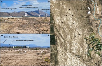
We can identify at least three terrace levels within sectors 1 and 2. This implies that at least three base-level drop events have occurred since the desiccation of the lake. The first base-level drop formed the T3 level (Fig. 10a and b) and was responsible for the destruction and pedimentation of the original “lake” bottom. In the basin marginal areas of sector 1, a thin cap of alluvial deposits resulting from the progradation of surrounding alluvial fans covers the T3 terrace. Toward the basin center, the alluvial fan–capping sediments become discontinuous and present as channelized gravel deposits. This gravel cap protected the underlying deposits from erosion. In the area where gravels are present only as channelized deposits, the second base-level drop formed an inverted relief where gravel channels remained on the top of longitudinal crests as the only remnants of T3. The last event formed level T1 and introduced the current base level. This resulted in the incision and formation of a badland landscape with streams and gullies. These terrace levels have divergent profiles downstream—T1 being steeper than T2 and T3.
(color online) (a) Remnants of channelized gravel deposits in the uppermost level of Valentín Formation topping longitudinal crests as relicts of terrace level T3. This inverted relief is interpreted as result of differential denudation. (b) Photograph of the three terrace levels recognized in sector 1. (c) Satellite image showing longitudinal crests resulting from differential denudation of old channelized gravel deposits. E, east; N, north; W, west.

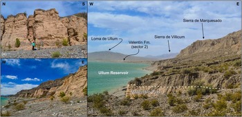
In sector 3, a long remnant slice of the Valentín Formation outcrops in a north–south ravine in the Sierra de Marquesado western piedmont (Fig. 11). Here, fine-grained deposits interfinger with alluvial gravels from the western piedmont of the Sierra de Marquesado. The sequence begins with alluvial deposits constituted by fine monomictic clast-supported calcareous conglomerates. Overlying in sharp contact, the Valentín Formation develops as a rhythmic alternation of clay, silt, and fine sand beds ~5 cm thick. Upward, silt and fine sand beds become thicker and dominant, whereas clays are scarce. There are also some channelized piedmont-related gravel lenses. The top of the Valentín Formation appears truncated by pedimentation processes and then covered by a piedmont-related calcareous gravel cap (Fig. 11c).
(color online) (a) Main outcrop of Valentín Formation in sector 3. (b) The Valentín Formation exposure in this sector has a wedge shape, disappearing to the north (N) and south (S) within the deposits of the western piedmont of the Sierra de Marquesado. (c) View showing pedimentation and alluvial fan progradation on top of the Valentín Formation. N, north; S, south; E, east; W, west.

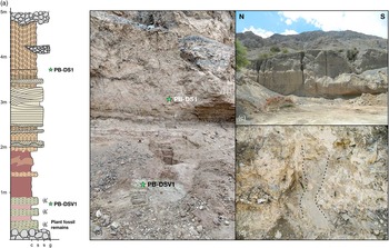
In sector 5, a 10-m-thick succession of the Valentín Formation is exposed in a quarry (Fig. 12). The succession begins with clast-supported monomictic calcareous conglomerates with rounded clasts and a mean size of ~10 cm. The origin of this deposit remains largely unknown because it was discovered and observed only in a small pit on the bottom of the quarry. Its texture seems different from the typical colluvial deposits of the nearby piedmont of Sierra Chica de Zonda, because it has bigger and more rounded clasts. Upward, in sharp concordant contact, we find well-laminated white-greenish clayey silt with abundant plant fossil remains with a superimposed red iron oxide coat. This layer is consistent with the apparent base of the Valentín Formation. AMS radiocarbon dating of organic sediment from this greenish clayey silt yielded an early Holocene age of 8420±30 14C yr BP (9475–9400 cal yr BP). This layer is overlain, in gradational contact, by a 1-m-thick bed of very plastic black-spotted brown massive clays, apparently without fossil content, and by a banded layer of clays with soft sediment deformation structures (pseudonodules) of a few centimeters. Upward, there is a 1-m-thick layer of well-sorted brown sand with planar cross stratification and detrital manganese laminae with a superimposed red iron oxide coat. A pale-brown clayey silt layer, with carbonate cement and a blocky texture, overlies this bed. Piedmont-related gravel lenses are present in the middle to upper part of this layer. Conventional radiocarbon dating of an organic-rich layer (Fig. 12a) yielded an age of 7230±180 14C yr BP (8191–7828 cal yr BP), which coincides with the end of the early Holocene. Sand dikes were also observed in this level, possibly related to a seismic event (Fig. 12d). Finally, the top of the outcrop was truncated by pedimentation processes and a new layer of piedmont-related gravels that overlies the Valentín Formation uncomformably.
(color online) Schematic stratigraphic log (a) and photographs of sector 5 Valentín Formation exposure (b, c). (d) Sand dikes observed in the upper levels of Valentín Formation exposure in sector 5. N, north; S, south.

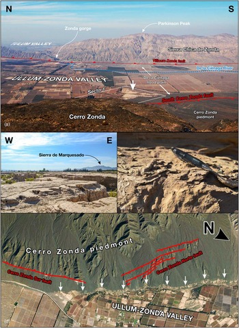
In the southernmost part of sector 6, lateral transition from alluvial to lacustrine facies is present indicating the approximate location of the place where the De la Ciénaga River alluvial plain entered into the lake (Fig. 13a). This outcrop is characterized by ~10-cm-thick fine to middle sand layers with trough cross stratification and lenses of polymictic clast-supported conglomerates. Thin layers of clayey silt and sandy silt with carbonized vegetal remains can also be observed. These layers become thicker and dominant basinward. Desiccation cracks are a common feature in clays, as well as dish structures. Trace fossils (galleries, tubes, and burrows) are also common in these fine-grained layers (Fig. 13c). A little farther north, fine-grained deposits interfinger with the monomictic clast-supported conglomerates of the northeastern Cerro Zonda’s piedmont. These deposits, composed of ~7-cm-thick greenish to brownish clayey silt and fine sand layers (in a lower proportion), are distributed into a long and thin slice that resembles a topographic contour line. This suggests these deposits mark out an ancient shoreline (Fig. 13d). AMS radiocarbon dating of the topmost silt layer yielded an early Holocene age of 6930±30 14C yr BP (7835–7685 cal yr BP).
(color online) (a) View showing the location of sector 6 southern outcrop. (b) Landscape of the sector 6 southern outcrop. (c) Dish structures and trace fossils (galleries, tubes, and burrows). (d) Google Earth oblique view of the Cerro Zonda’s northeastern piedmont (sector 6) showing the ancient lake shoreline and its spatial relation with the Cerro Zonda Norte and Cerro Zonda Sur Faults. N, north; S, south; E, east; W, west.

Groundwater well data
In addition to surface data, we analyzed several geologic logs from existent groundwater wells across the Ullum-Zonda valley (Fig. 5). In the northern part of the valley, these profiles showed a cyclic intercalation of ~1- to 30-m-thick alluvial and lacustrine facies as deep as 140 m (maximum drilled depth). In the deepest well, we identified at least nine alluvial-lacustrine facies intercalations. In the central part of the valley, there are almost no lacustrine facies, whereas alluvial facies are dominant. In the southern part of the valley, we identified one or two lacustrine facies in most profiles, but without the cyclic intercalation observed in the northern part of the valley.
Current and past basin morphology
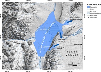
A paleogeographic reconstruction of the paleolake was made using ASTER (Advanced Spaceborne Thermal Emission and Reflection Radiometer) (30 m) DEM and the highest topographic outcrop of the Valentín Formation (820 m asl) (Fig. 14). The resulting lake encompassed an area of 140 km2 that flooded most of the Ullum-Zonda valley. This reconstruction showed that a lake of such size should have had three huge spilling points across the Zonda and Ullum gorges and the Loma de las Tapias–Loma de Ullum watershed. The assumption underlying this scenario is that the spillways had a depth of several meters, which renders the existence of such a lake very unlikely.
(color online) Paleogeography of the Ullum-Zonda valley showing the hypothetical extent of the Paleolake Ullum-Zonda with water level fixed at 820 m above sea level (maximum topographic altitude of Valentín Formation outcrops). The three major overflows across the Zonda gorge, Ullum gorge, and Loma de las Tapias–Loma de Ullum watershed suggest that the shape of the valley has changed since the deposition of the Valentín Formation.

Sector 6 is the only place where the ancient shoreline of the Paleolake Ullum-Zonda could be recognized (Fig. 13d). Although it was not possible to find a fault scarp, GPS data allowed us to identify a 13 m slope between the outcrops south and north of the inferred Cerro Zonda Norte Fault trace. Unless deformed by tectonic activity, shorelines should be horizontal, as they coincide with a gravitational equipotential surface (water surface of the lake).
DISCUSSION
Based on the data obtained through this study, it is possible to identify at least two different and apparently separate chronostratigraphic units within Valentín Formation: a unit of a late Pleistocene age, which is located in sector 1 (Fig. 5); and a unit of early to middle Holocene age that covers all the other sectors. Holocene deposits are located in the marginal areas of the valley (sectors 2 to 6). So far, it has not been possible to establish their relationship with the late Pleistocene unit. There is a 5600 yr gap between the minimum age obtained for late Pleistocene outcrops and the maximum age obtained for Holocene exposures. It is possible that the Holocene unit deposited marginally to the late Pleistocene unit, as there is no correlation between age and topographic height of the samples. For instance, the Holocene deposits of sector 5 are located at a lower altitude than the late Pleistocene deposits of sector 1. Another possibility, though remote, is that late Pleistocene deposits were uplifted and eroded, obliterating any Holocene strata that could have been present in the upper levels of the outcrop. However, according to Colombo et al. (Reference Colombo, Busquets, Ramos, Vergés and Ragona2000), terrace levels that are divergent downstream—like those described in sector 1—may indicate a local base-level drop rather than tectonic uplift. Given the lack of detailed stratigraphic studies, the outcrops usually linked to the Valentín Formation could actually encompass more than one lithostratigraphic unit, and even unrelated lithostratigraphic units.
In sector 1, the Valentín Formation is characterized by an alternation of mainly white-brownish silts and clayey silts and well-sorted fine sands with massive to trough cross stratification. Mehl and Zárate (Reference Mehl and Zárate2014) propose the existence of hyperarid conditions in the Andean foreland and high water outputs from the Andean rivers between 33°S and 34°S prior to 13,000 yr BP. It is likely that those conditions were also present in the Ullum-Zonda valley (31°30′S) during that time. The gypsum crystals observed in sector 1 deposits may indicate arid conditions during deposition. The great extent and thickness of these outcrops may also suggest that the valley received high sedimentary inputs. If the hyperarid hypothesis is true, only the San Juan River could have carried this amount of sediments into the valley. These environmental conditions could already have been established by 13,790±50 14C yr BP (16,770–16,440 cal yr BP at 2σ) and lasted at least till 12,790±40 14C yr BP (15,330–15,160 cal yr BP at 2σ), which coincides with the end of the last glacial maximum. No further data have yet been obtained to reveal what happened between the end of sedimentation and the beginning of terracing of these deposits, which could have occurred sometime after 6930±30 14C yr BP (7835–7685 cal yr BP at 2σ). Conceivably, this base-level “drop” had at least three phases (probably during middle Holocene) and accounts for general terracing and pedimentation of the Valentín Formation.
In sector 5, deposition of the Valentín Formation would have begun at least shortly before 8420±30 14C yr BP (9475–9400 cal yr BP at 2σ). If the underlying conglomerates were deposited within an alluvial environment—and considering their sharp contact with overlying fine-grained deposits—it is possible to assume there was a sudden rise of the base level during this time. The white-greenish clayey silt with a very high content of fossil vegetal remains indicates that this alluvial environment gave rise to a slightly reducing palustrine environment with the development of reeds. The following coarsening upward sequence from brownish clays to banded clayey silts and well-sorted sands may be related to a progradation of fluvial systems. Shortly before 7230±180 14C yr BP (8191–7828 cal yr BP at 1σ), influence from the western Sierra Chica de Zonda piedmont began as white-brownish clayey silts from the upper levels of the sequence are bound with carbonate cement and are interfingered with calcareous conglomerates lenses.
On the other hand, in sector 2, the transition from alluvial to lacustrine facies deposition began around 7460±30 14C yr BP (8330–8180 cal yr BP at 2σ), probably during a second base-level rise. This second expansion would have had its climax around 6930±30 14C yr BP (7835–7685 cal yr BP at 2σ) when the sector 6 shoreline was formed. Sector 3 outcropping deposits could also be related to this second expansion of the lake.
Groundwater well geologic logs show that the occurrence of lacustrine-palustrine episodes within the Ullum-Zonda valley could have been quite common during the Late Pleistocene—with probably nine episodes during that period. The lateral facies changes observed and the lack of apparent correlation between proximal wells may indicate that most of those lacustrine-palustrine episodes were constrained to relatively small areas and were not large enough to flood the entire valley. The considerable thickness of Quaternary deposits within the Ullum-Zonda valley may indicate a high subsidence rate for this tectonic depression. This means that periodic flooding could have derived both from the uplift of mountain blocks and pulses of strong subsidence of the valley floor.
The deformation observed in the ancient shoreline of sector 6 could be related to middle to late Holocene activity of the Cerro Zonda Norte Fault. The 13 m vertical slope that affects deposits of 6930±30 14C yr BP (7835–7685 cal yr BP at 2σ) may imply a mean vertical uplift rate of ~0.8 mm/yr in the hanging wall block. This value is consistent with the rates reported by Siame et al. (Reference Siame, Bellier, Sebrier and Araujo2005) for the northern Loma de Las Tapias segment of the Villicum-Zonda Fault. In sector 2, fault propagation folds and growth strata observed in Quaternary alluvial deposits related to the Villicum-Zonda Fault may have formed during late Pleistocene to early Holocene and were still active prior to, but not far from, 7460±30 14C yr BP (8330–8180 cal yr BP at 2σ), as they affect the underlying alluvial deposits close to (but apparently not cutting through) the Valentín Formation.
Potential of correlation with worldwide climate proxies
The obtained radiocarbon ages show that the Paleolake Ullum-Zonda spanned from at least the last glacial maximum and across the middle Holocene climate optimum producing an important geologic record of major climate shifts in the Andes Mountains and the Andean foreland. The late Pleistocene unit is coeval with the end of Marine Oxygen Isotope Stage (MIS) 2, and, thus, it could contain important evidence of environmental conditions during the end of the last glacial period in the foreland of the central Andes of South America. The Holocene unit, on the other hand, is contemporary with MIS 1 and lasted from 9475 to 7685 yr BP. This unit could be a relevant source for climatic proxies in the Southern Hemisphere for this period, which includes important events like the Northern Hemisphere 8200 yr BP cold stage and the Holocene climatic optimum among others.
CONCLUSION
The Ullum-Zonda tectonic depression, which is located in the central Andes Precordillera, records several episodes of shallow temporary lakes originated from natural damming of the San Juan River during the late Quaternary. This sedimentary infill is called the Valentín Formation. Valentín Formation outcrops currently occupy an area of more than 200 km2.
The Valentín Formation can be divided in two chronostratigraphic units: a late Pleistocene age (16.7–15.2 ka BP) unit and an early to middle Holocene (9475–7685 yr BP) unit. The stratigraphic relationship between these units could not be established.
The Ullum-Zonda valley may have been subjected to high water and sediment inputs from the San Juan River in arid to hyperarid conditions during late Pleistocene. These conditions may have already been established by 13,790±50 14C yr BP (16,770–16,440 cal yr BP at 2σ) and lasted at least till 12,790±40 14C yr BP (15,330–15,160 cal yr BP at 2σ), which coincides with the end of the last glacial maximum.
The Holocene unit evidences two transgressive events. The first occurred shortly before 8420±30 14C yr BP (9475–9400 cal yr BP at 2σ) and the second around 7460±30 14C yr BP (8330–8180 cal yr BP at 2σ), both as a result of a sudden rise of the base level. The paleolake reached its maximum extent in 6930±30 14C yr BP, shortly before the lake desiccated.
Terrace formation in sector 1 occurred because of three stages of local base-level drop sometime after 6930±30 14C yr BP (7835–7685 cal yr BP at 2σ).
Subsurface data show that lacustrine episodes were common during the late Pleistocene—with probably nine episodes during that period. The considerable thickness of Quaternary deposits within Ullum-Zonda valley may indicate a high subsidence rate for this tectonic depression. Uplift of mountain blocks together with strong subsidence of the valley floor may account for periodic flooding in this valley.
Late Pleistocene to early Holocene fault propagation folds and growth strata in Quaternary alluvial deposits relate to the Villicum-Zonda Fault and may indicate Holocene activity for this fault in sector 2. The deformation observed in the ancient shoreline of sector 6 could be related to middle to late Holocene activity of the Cerro Zonda Norte Fault at a mean vertical uplift rate of ~0.8 mm/yr in the hanging wall block.
ACKNOWLEDGMENTS
We gratefully acknowledge Lewis Owen and the Quaternary Research editors, as well as reviewers Franck Audemard and Gustavo Martínez for their constructive comments and suggestions to improve our paper. We personally thank PhD Franck Audemard for our useful in-depth discussions throughout this research. We also thank Flavia Tejada, Martín Mendoza, Nicolás Vargas, and César Villafañe for their valuable help during fieldwork. This work was funded through Projects 1E/750 CS-CICITCA and PICTO 2009 UNSJ-0013- Préstamo BID.