

INTRODUCTION
Much of what has been written about the Athenians and their territory focuses primarily upon topics concerning the city-state's civic institutions, society and economic outputs.Footnote 1 From these studies we understand that there were several opportunities, located in civic centres, markets and cult sites throughout Attica, for individuals to engage with social practices at varying distances from their primary centre of residence. We know, for example, that acts of civic participation in rural demes and Athens were not mutually exclusive activities for the individual (Whitehead Reference Whitehead1986, 317–24, 353–7; Stanton Reference Stanton, Coulson, Palagia, Shear, Shapiro and Frost1994, 220);Footnote 2 the same is true for the markets used by the residents of Attica (Bresson Reference Bresson2016, 236–8). In addition to the identification of a variety of physical spaces in Attica where individuals could come together, scholarship has also reconstructed the diversity of the civic, social and familial connectivityFootnote 3 of Athenian society. Given that we know, from scholarly reconstructions, that networks of connectivity were diverse and that these centres were spread out, we may presume that travel over short-, medium- and long-range distances was part of life for people living in the countryside as well as in the city. Accordingly, individuals living beyond the immediate vicinity of the institution they wished to access may have been willing to spend time travelling to such centres. But as we do not fully understand the practicalities involved in travel, little has been said about how individuals experienced movement through the landscape and the difficulties involved in doing so.
The aim of this research is to test the hypothesis that travel and general mobility of the population occurred throughout Attica as individuals travelled with the intention of fulfilling their civic roles and economic objectives, and practising religious observance; this will be undertaken by using an analysis of the textual and archaeological evidence along with computer modelling. Scholarship has begun to recognise the importance of travel, the landscape and roads as experiences in themselves. Recent interest in the role of roads as essential facilitators of connectivity has offered significant insight into the social role of roads more generally (Gibson Reference Gibson2007; Arrington Reference Arrington2010; Sobak Reference Sobak2015).Footnote 4 For example, the work of Sylvian Fachard and Daniele Pirisino (Reference Fachard, Pirisino and Miles2015) illuminates the importance of roads for cross-border community interactions and connectivity along the Athenian borderland. Moreover, Erin Gibson (Reference Gibson2007) focusses upon the archaeology of movement, particularly on how roads act as facilitators for social interactions within the local community. The investigation presented here shares the interest of recent scholarship in the social importance of roads in fostering and maintaining civic and social interaction, and, in turn, builds upon this work. This article differs, however, in its focus upon the practicalities of short-, medium- and long-distance travel with the aim of differentiating aspects, modes and reasons for travel; it asks how this may have impacted a traveller's ability to engage with wider social institutions.
To explore these issues fully, I intend to investigate the practicalities of travel for the ancient Athenian travelling across Attica. I model the connectivity of the landscape for the individual, whether resident in the city, deme or countryside.Footnote 5 In doing so, I aim to illustrate the extent to which time and distance may have affected the individual's decision to travel and the means by which they could lessen the physical and time costs of travelling over greater distances.Footnote 6 I generate scenarios drawn from the textual evidence discussed throughout this paper and compare them to the descriptions of routes and travel times noted by early nineteenth-century travellers through Attica. My purpose is to test the temporal and physical cost of short-, medium- and long-range travel for individuals between demes and Athens using computational scenarios, with the purpose of exploring the feasibility of travel and, in turn, of understanding the nature of the individual's journey through Attica.Footnote 7
This paper offers a new perspective by focussing upon human movement across the landscape. Questioning the nature of travel in ancient Attica allows us to expand the definition of democratic, ritual or other social participation as an all-encompassing process. In the application of this holistic approach, we can posit better-founded assumptions regarding how travel was realised through physical effort, while generating further questions regarding how travel affected the decisions Athenians made regarding participation in wider social institutions.
THE ATHENIAN ROAD NETWORK
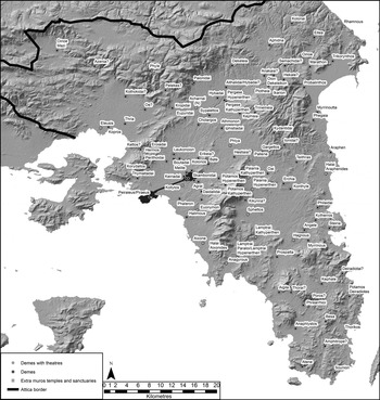
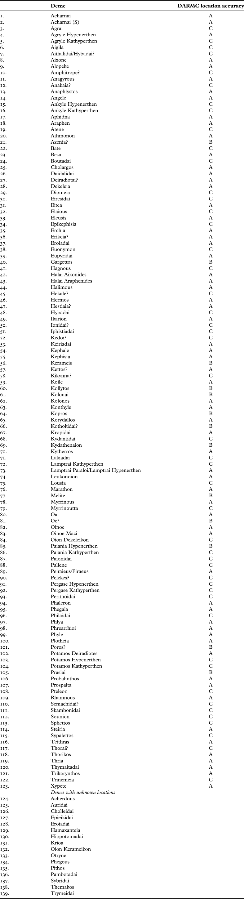
Attica (Fig. 1) was large in comparison to contemporary city-states; in the fourth century bce its territory consisted of 139 demesFootnote 8 (Table 1) spread over an area of 2500 km2.Footnote 9 The settlement dataFootnote 10 reflect a high population count,Footnote 11 with a landscape made up of a patchwork of settlement types falling across a spectrum of social complexity, from nucleated demes to more widely distributed hamlets and individual households dotted throughout the countryside.Footnote 12 As such, some demes had their own social, economic and civic infrastructure, meaning that individuals could access resources without need to travel further afield (Bintliff Reference Bintliff, Olshausen and Sonnabend1994; Reference Bintliff, Olshausen and Sonnabend2002).
Map of Attica showing the locations of demes, deme theatres, larger temples and sanctuaries.

List of demes with location accuracy. Site locations are based on those in the Barrington Atlas of the Greek and Roman World as digitised by The Digital Atlas of Roman and Medieval Civilisations (DARMC; https://darmc.harvard.edu/). Sites ranked A (63 demes) have had their locations confirmed using additional spatial investigation. Sites ranked B (13 demes) have been moved from digitised map coordinates to coordinates based on subsequent research. Sites ranked C (47 demes) have not been moved from their digitised map coordinates and their location is uncertain.

As a result, it is plausible that there were instances when the individual's civic, economic and religious needs could be met within their local territory. For example, the Marathonian Tetrapolis was a cult organisation centred on the demes of Marathon, Probalinthos, Trikorynthos and Oinoe (Strabo 8.7.1). The Tetrapolis consisted of a ‘hierarchical religious network’ made up of small local and regional sanctuaries linked through the structure of the Tetrapolis (Ismard Reference Ismard, Taylor and Vlassopoulos2015, 88). The epigraphic evidence demonstrates that the Tetrapolis had a sophisticated cult organisation within a micro-region of Attica. The grouping of several local and regional cult sites within the territory of Marathon gives a clear indication not only of the complexity inherent in the religious calendar and the social connections upon which these organisations relied, but also the connectivity and repeated movement across the Marathonian plain and surrounding countryside necessary to maintain cultic observance. In addition to the well-developed cult system of the Tetrapolis, the region was also connected to wider Athenian cult practices; the Herakleion of Marathon,Footnote 13 for example, held importance as a regional cult centre and also served as a locus for a civic festival, which included a competition involving 30 men from the 10 Athenian tribes (Vanderpool Reference Vanderpool1942, 333–5). This means that the festival required those living in other regions to travel to Marathon ([Aristotle], Athenian Constitution 54.7; Ismard Reference Ismard, Taylor and Vlassopoulos2015, 92–5). Thus, this instance serves as a good example not only of local travel, but also travel across Attica for participation in cult activity.
The case of the Marathonian Tetrapolis illustrates the potential connectivity of the Athenian landscape, and serves to highlight both how repeated movement could be achieved within a micro-region and, furthermore, how the Tetrapolis connected to broader Athenian civic structures. However, not all settlements within Attica were equally large and self-supporting (Bresson Reference Bresson2016, 155–6). In the case of Atene, for example, Hans Lohmann argues that the deme was made up of a loose cluster of settlements with no defined centre (Reference Lohmann and Wells1992, 33–5; see the archaeological survey of Atene in Lohmann Reference Lohmann1993). As such, we can assume that it was perhaps necessary for inhabitants of such demes to travel to fixed centres to attend civic meetings, markets and other social gatherings.
Whatever the case may be, it is likely that rural individuals chose to travel, perhaps irregularly, further than their local settlement for several reasons. Although we do not have a definitive proportion of the rural population in comparison to its urban counterpart, the archaeological and textual evidence demonstrates that there was active participation in social institutions by rural individuals (Markle Reference Markle1990; Osborne Reference Osborne1991; Kellogg Reference Kellogg2013, 39–53).Footnote 14 With this in mind, we can turn our attention to the practicalities involved in travel, beginning with the Athenian road network.
Despite the uncertainty and dangers inherent in overland travel (Horden and Purcell Reference Horden and Purcell2000, 377), it is likely that there were networks of carriage roads, with deliberately cut grooves to support wheeled carts, throughout Greece (Pikoulas Reference Pikoulas, Adams and Roy2007, 82–6).Footnote 15 In addition to constructed roads, the textual and archaeological evidence attests to a variety of smaller roads, paths and tracks throughout the countryside (Kakavogianni Reference Kakavogianni and Korres2009, 184).Footnote 16 This assertion is supported by region-specific studies, which have identified important routes through their respective landscapes at Euboea, Arkadia, Laconia, the Megarid and the Argolid (Hammond Reference Hammond1954; Young Reference Young1956; Armstrong, Cavanagh and Shipley Reference Armstrong, Cavanagh and Shipley1992; Pikoulas Reference Pikoulas, Nielsen and Roy1999; Reference Pikoulas2012; Wells Reference Wells, Ascani, Gabrielsen, Kvist and Rasmussen2002; Keller and Hom Reference Keller and Hom2010; Fachard Reference Fachard2012). Across mountainous landscapes, road engineers went to considerable lengths to make steeper slopes passable either for carts or on foot. If the terrain allowed, road-beds were carved from the bedrock and supported with retaining walls, as at Phyle (Fachard and Pirisino Reference Fachard, Pirisino and Miles2015, 141). Equally, there is evidence for non-carriage roads that supported travel with a mule or on foot. For example, Pausanias (8.6.4) describes the character of a route into Arcadia travelling over Mount Parthenius, which the locals term ‘The Ladder’ because of the steep rock-cut steps, suggesting that the route supported pedestrian traffic only, rather than carts. Similarly, Berit Wells, writing about the Kontoporeia (an ancient route mentioned in sources running through the Argolid), comments that its name may stem from the Greek word for ‘staff’ (κοντός), because ‘the traveller should be equipped with a staff as the route is an arduous climb’ (Reference Wells, Ascani, Gabrielsen, Kvist and Rasmussen2002, 70).
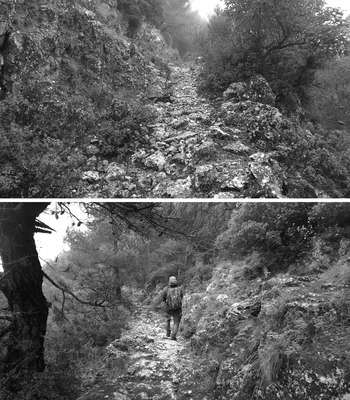
To facilitate travel across a mountainous landscape, such as Attica, ancient road builders engineered switchbacks;Footnote 17 paths across hillsides were levelled out by cutting into the slope and creating retaining walls, which in turn allowed the movement of people along steeper elevations (Hammond Reference Hammond1954, 105–6; Fachard and Pirisino Reference Fachard, Pirisino and Miles2015, 141). Some of the best examples of ancient road engineering in Attica are ‘Hammond's Road’ (the route from Boeotia to the Peloponnese), the ‘Road of the Towers’, Oinoe Road and Panakton Road; there are several places along these routes that feature switchbacks, terrace walls, levelling out of slopes and wheel-ruts cut into the bedrock, all of which illustrate the care taken to make steeper elevations passable for pedestrians and wheeled vehicles (Fachard and Pirisino Reference Fachard, Pirisino and Miles2015, 140–1). Figure 2 illustrates the nature of Hammond's Road and, in particular, how ancient road engineers cut into the slope to make steeper elevations passable. In general terms, it is likely that some roads supported wheeled carts, while others supported pedestrian travel or pack-animals, and that the design and nature of the route depended upon the topography.
Sections of Hammond's Road (photograph by the author).

It is possible that parts of Attica had constructed roads, as opposed to dirt tracks, from the Mycenaean period onward (Kakavogianni Reference Kakavogianni and Korres2009, 183; Fachard and Knodell Reference Fachard, Knodell, Wright, Papadimitriou, Fachard, Polychronakou-Sgouritsa, Andrikou and Banouforthcoming). For later periods, we have limited evidence, based on ancient testimonia, that, during the Archaic period, Hipparchus set up herms along routes through Attica ([Plato], Hipparchus 228d; Quinn Reference Quinn2007, 94–5).Footnote 18 The sole surviving example of such a herm (IG I3 1023) was discovered at the mid-point between Athens and ancient Kephale (Pritchett Reference Pritchett1965, 161; Lohmann Reference Lohmann and Goette2002, 77; Tomlinson Reference Tomlinson and Goette2002, 35). This type of monument, according to Ps-Plato, was set up across ‘Attica along the roads in the midst of the city and every district town’ ([Plato], Hipparchus 228d); they served not only as distance markers, but also encouraged the population to make connections between settlements across the landscape (Fachard and Pirisino Reference Fachard, Pirisino and Miles2015, 143).Footnote 19 The setting-up of these herms implies that there was a road network in place in Attica, at least, by the Archaic period (Kakavogianni Reference Kakavogianni and Korres2009, 183–4).
We have greater evidence of road construction in the Classical period, as there were five elected hodopoioi (road builders) whose job it was to supervise the repair of roads by public slaves ([Aristotle], Athenian Constitution 54.1; Ober Reference Ober1985, 97; Pritchard Reference Pritchard2015, 83). Of course, it is likely that state-funded road maintenance took place, if at all, primarily on the larger roads attested in ancient texts, particularly the sacred route to Eleusis; smaller roads, paths and dirt tracks were maintained, if at all, by local communities.Footnote 20 There is limited evidence for the role or even the existence of the hodopoioi in Attica after the fourth century bce. Although it hails from a different geographical and temporal context, an Attalid law on the municipal administration of Pergamon, placing responsibility for the upkeep of roads and footpaths on owners of property adjacent to a road, serves as a parallel from which we might extrapolate (SEG 8.521 lines 30–5). According to this law, the astynomoi oversaw road maintenance and had the power to issue penalties for non-compliance (SEG 8.521 line 35). In general terms, it is likely that, rather than state officials organising the upkeep of roads, responsibility for road maintenance fell upon the local community with oversight by local government officials. For example, an early third-century bce inscription from Kyrrhos in Macedonia records the agreement between the territories of Kyrrhos and Genderrhos, which includes provision for the upkeep of inter-territory roads (EKM II 401 in Gounaropoulous, Paschidis and Hatzopoulos Reference Gounaropoulou, Paschidis and Hatzopoulos2015). In particular, it states that the community is to contribute to the restoration and repair of the streets (González and Paschidis Reference González and Paschidis2017, 185). Sometimes it appears that the same roads were in use for several centuries. For example, Pausanias (1.44.6) describes the road between Megara and Corinth (the Scironian Road), and reports that it was widened under Hadrian's rule. With this information we can begin to reconstruct a picture of the Athenian road network, which, from the Archaic period, and perhaps earlier, extended through Attica, and was constructed (in parts) and perhaps irregularly maintained, either by the state or local communities, to support the movement of people across the landscape.
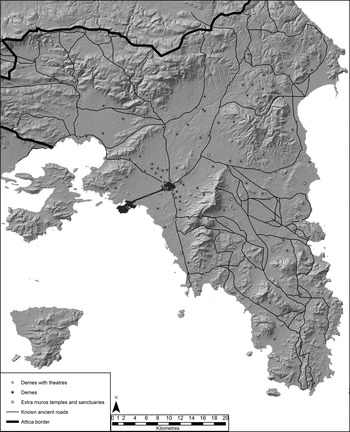
Twentieth-century topographers mapped several ancient roads in the north of the territory; they were originally considered ‘military roads’, as were sections of the Road of the Towers and the Oinoe and Panakton roads (see Ober Reference Ober1985; cf. Fachard and Pirisino Reference Fachard, Pirisino and Miles2015, 139–54). Recently, however, it has been suggested that they facilitated the movement of people for political and economic reasons in addition to military (Fachard and Pirisino Reference Fachard, Pirisino and Miles2015, 142–8). It is conceivable that roads, particularly those reaching demes close to the borders of Attica, served to create a sense of connection between the deme and Athens; these roads could be considered ‘political roads’, intended to encourage integration of those at a distance from the city (Fachard and Pirisino Reference Fachard, Pirisino and Miles2015, 142). These conclusions are supported by the improved quality of the archaeological evidence for ancient Attic roads owing to rescue excavations associated with modern road building (Korres Reference Korres2009; Fachard and Pirisino Reference Fachard, Pirisino and Miles2015, 139).Footnote 21 The routes reconstructed hereFootnote 22 (Fig. 3) illustrate a major road network throughout the peninsula which provided access not only to Athens, but also to demes situated along the course of the roads, and connected other parts of the landscape on these principal routes (Korres and Tomlinson Reference Korres, Tomlinson and Goette2002, 44–5; Kakavogianni Reference Kakavogianni and Korres2009, 184).
Known ancient Athenian roads.

Attica, then, had a framework of roads appropriate to its geographic size, population level and social complexity. These roads, if well-kept, afforded opportunities for the population to engage with a broad spectrum of civic, religious and economic activities at varying distances from their centre of residence. Concerning the individual's journey, these road systems could offer different routes to the same destination. Thus, the nature of an individual's journey, their need to bring supplies or to travel within a group or with an animal would clearly impact their route choice. Consequently, it is possible to surmise that there was a conscious thought process behind the choice to travel and that the individual was actively engaged with, and aware of, their landscape, the nature of routes and their travel intentions when undertaking a journey.Footnote 23 The Athenian road network served as a means to travel throughout Attica, and, in turn, created a point of interaction between the individual, their travelling companions (if any) and the landscape they traversed. Therefore, we can conceive of roads as spaces for interaction and communication within an interconnected Athenian social landscape.Footnote 24
The physical connectivity of the Athenian landscape and the experiences of travelling through it are just as important as any ideological or economic impetus that drove individuals to participate in wider Athenian civic, economic and religious practices. In order to grasp how the Athenian landscape served as an essential facilitator of interaction, we should not conceive of Attica as a passive backdrop made up of mountains, plains and valleys, but as a social landscape made up of nodal points which presented the individual with opportunities to participate in multiple types of activities.
MEANS OF TRAVEL
One difficulty we encounter in trying to reconstruct journeys using the Athenian road network is that the means of travel are rarely expressed in texts; we must, therefore, rely on the implicit context rather than explicit statements in the majority of cases. For example, the movement of individuals is an important aspect of Lysias’ On the Murder of Eratosthenes, where Euphiletus travels to the countryside for an undetermined length of time (but long enough, he alleges, to allow his wife to carry on an affair while he is gone: Lysias 1.11). When Euphiletus wishes to confront the man who is making him a cuckold, he tries to gather witnesses but finds his neighbours not at home (Lysias 1.23–4). Euphiletus does not mention how he moves to and from the city and countryside; since he seems to be travelling alone, should we assume that he is on foot or on horseback?
Concerning the movement of individuals, rather than military groups on horseback, our best evidence comes from Xenophon's Oikonomikos, in which Ischomachus, arguably a ‘typical’ wealthy Athenian, travels frequently to his farm on horseback (11.15–16).Footnote 25 In Ischomachus’ case, however, the purpose of riding the horse is to train it in military discipline, rather than to use it as a mode of travel. Since ancient Greek horses were likely unshod, the risk of injury to the hoof and leg was very high, especially when travelling over rough and uneven mountainous terrain (Griffith Reference Griffith2006a, 197).Footnote 26 It is conceivable that the risk of injury to the horse, and the resulting loss of the animal, made travel exclusively by horse precarious.
Of course, the cheapest form of travel was by foot; there is considerable evidence, albeit related to within the city itself, for people walking while in discussion or being in the process of walking to their destination when they come upon a person or event (Montiglio Reference Montiglio2005, 180 n. 1).Footnote 27 The social relevance of walking meant that the prospect of walking to a destination was not a deterrent to travelling throughout Attica (e.g. for pilgrimage: Dillon Reference Dillon1997, 35–6). Moreover, individuals could travel on a mule or donkey. According to Mark Griffith's in-depth discussion (Reference Griffith2006a; Reference Griffith2006b), mules were favoured animals for work owing to their dependability, longevity and versatility; they were used for labour along with donkeys and oxen. In addition to physical labour, they could be used also by individuals as riding animals (Griffith Reference Griffith2006a, 225). Unlike horses, whose use was confined to male riders (Griffith Reference Griffith2006a, 202), individuals of different ages and genders are shown riding side-saddle on donkeys and mules (Griffith Reference Griffith2006a, 225). In the examples of road types discussed in the previous section, it is likely that the choice of whether to walk or ride an animal to an individual's destination was dependent upon the nature of the route, length of journey and considerations concerning the practicalities of sheltering an animal if the journey required an overnight halt.
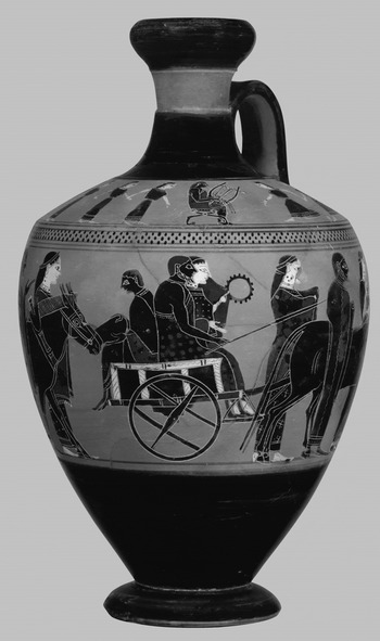
There was a third option, which groups of travellers may have adopted, as illustrated by a remarkable dedication by a coachman.Footnote 28 Its relief illustrates a coachman standing by his cart, pulled by two mules (Kourinou Reference Kourinou, Adams and Roy2007, 88–9). The iconographic evidence of travel by mule-cart has helped illustrate that this conveyance was perhaps used along suitable roads.Footnote 29 In the case of Demosthenes’ Against Phaenippus, the plaintiff travels with witnesses out to the defendant's farm (42.5) and recalls the movement of large amounts of harvested wood off the property using carts (42.7). In addition to industrial labour, mule-carts were also employed for more prestigious roles such as wedding processions (Fig. 4) and Olympic sporting events.Footnote 30 Thus, travel by cart was a possible option for larger groups wishing to travel together along routes that could accommodate a cart. But the textual evidence gives little insight into how groups travelled to a shared destination. For example, in Isaeus’ On the Estate of Astyphilus, Euthykrates is assaulted by Thoudippus on a farm that was contested as part of an inheritance case (Isaeus 9.17–20).Footnote 31 It is feasible that the witnesses travelled to Athens to attend the trial concerning the assault. Should we assume that they travelled as a group, on foot or by cart? If as a group, they may have chosen to travel together to lessen the financial cost of travel by sharing a conveyance, given that they had a shared destination and purpose in mind.
Athenian black-figure lekythos attributed to the Amasis Painter, illustrating a wedding procession with pedestrians and two mule-carts carrying four passengers each (550–530 bce) (New York Metropolitan Museum of Art 56.11.1; https://www.metmuseum.org/art/collection/search/254843).

The experience of a traveller was one which took into account both the individual and the landscape, consisting of multiple decisions aimed at achieving the intended outcome of the journey. This connectivity and the factors that influenced travel would likely affect the experience of the traveller and, in turn, would influence their willingness to undertake repeated journeys. As a result, we can conceive of the traveller's experience as a continuous dialogue between the individual and the landscape, where the individual sets out on their journey with an intended route and outcome in mind, and, while on the journey, remains aware and capable of adapting to changes in their route, travelling companions or destination.
A METHOD TO MODEL MOVEMENT AND TIME
To test the assumptions made above, I employ computational modelling to reconstruct potential route choices, times of journeys and difficulty of travel using documented historical journeys through Attica as case studies. The scenarios below are framed by a concept borrowed from a pre-existing field of social geography known as time geography.Footnote 32 In broad terms, this concept allows us to envisage travel from the perspective of the individual undertaking the journey (Charleux Reference Charleux2015, 262–3). Specifically, the concept supports the notion that the landscape, the traveller and other objects, people, places and things interact with one another and help shape the ultimate outcome of the journey (Mlekuž Reference Mlekuž, Contreras, Forjas and Melero2010, 2). Equally relevant are the geographically and temporally fixed venues, including markets, assemblies and so on, that form space-time anchors (Miller Reference Miller2007, 512), toward which individuals must make a journey if they wish to participate in a specific activity. It is in the following scenarios that I will model the mobility of individuals, and in turn, the accessibility of these fixed space-time anchors. The methodologies employed here are not particularly complex, and the models are generated from the topography of Attica, with no temporal specificity or regional context. The aim in the following sections is to describe the accessibility of the landscape and the feasibility of travel from which we may make assumptions concerning time constraints for travel and interaction. Thus, this method helps to frame the following analyses and ground the abstract notion of the social landscape in real terms by discussing the practicalities of travel.
To create these scenarios,Footnote 33 the archaeological data (demes and roads) were digitised and combined with topographic data (elevation and slope) in order to generate a path-distance model and a least-cost-path model, which measure the difficulty of travel and potential routes across Attica respectively. Path-distance models are created by combining raster datasets of elevation, slope and cost-distance; Waldo Tobler's hiking function, which assigns values of time to movement across a slope, is applied too (Tobler Reference Tobler1993). The application of the path-distance model uses this data to create a cost-of-passage map that illustrates the predicted amount of time, in this case, needed to move from Athens across Attica. In simple terms, the path-distance model generates the length of a journey from a given point in the landscape by taking into account the starting point, elevation, slope and potential difficulty of travel, as defined within a geographic setting and set of parameters. We should be mindful of the fact that the path-distance model creates a time estimate from one source point for travel over all terrain without factoring in how weather or seasonal change may affect travel time. Despite its shortcomings, this is still a useful analysis as it helps to visualise the topography of Attica framed through time, which, as outlined above, is a useful method to measure the landscape in a manner relevant to the individual traveller.
The second analysis used in these scenarios is a model that generates the most physically cost-effectiveFootnote 34 route using the least-cost-path algorithm. A least-cost path is a route that minimises the total cost (physical effort) of moving between two locations (Connolly and Lake Reference Connolly and Lake2006, 294). Like the path-distance model, the least-cost-path model shares the same base data of slope, elevation and cost-distance rasters. Unlike the path-distance model, however, the least-cost-path model calculates a path between two points (in the case of this analysis, Athens and demes) following the path of least resistance based on the accumulated data from the elevation, slope and cost-distance rasters. Similarly to path-distance, this output predicts a route based on topography; we should acknowledge that the routes reconstructed here do not take into consideration any cultural, man-made or natural features in the landscape which may make travel along the predicted route impossible.Footnote 35 Therefore, the routes might not map perfectly onto existing or ancient roads. As a result, least-cost paths are a useful means to compare a known ancient road to a generated route that follows the path of least resistance, which in turn may help shed light on reasons behind certain route choices.
In order to create a thorough estimate of the experience of travel, this research uses a suite of approaches, including computational analyses, to measure the practicalities of travel, in combination with historical sources to gain insight into the human experience. Since our ancient source material gives incomplete descriptions of journeys, the discussion is supplemented with accounts of journeys undertaken by nineteenth-century topographers and antiquarians.Footnote 36 For this paper, Edward Dodwell's and William Gell's accounts of travels through Attica serve as supplements to the ancient texts. Both men intended to describe Attica and their travels with a specific focus on the classical past (Stoneman Reference Stoneman2010, 147–51). Dodwell, in particular, followed Pausanias’ route as closely as possible. As a result, at certain points, Dodwell and Gell came into contact with, travelled upon or at least moved in the same direction as ancient routes; they offer detailed information about the nature of the landscape, the ease of travel and the times of journeys, which we may use to supplement the conclusions drawn from the computational models.
There are, however, a number of caveats to consider when using the accounts of Dodwell (Reference Dodwell1819) and Gell (Reference Gell1819). Unlike Gell's unsentimental recording of distances and times with little or no description of the landscape, Dodwell's descriptions are framed by his wish to record the remains of ancient Greece with Pausanias as his guide (Whitley Reference Whitley2001, 45–6; Dyson Reference Dyson2008, 68; Loughlin Reference Loughlin2016). Thus, his romanticised descriptions of ancient ruins are contrasted with derisory references to the current population of Greece (e.g. Dodwell Reference Dodwell1819, 326–7; Stoneman Reference Stoneman2010, 149–50). Therefore, it is important to read Dodwell's accounts through a critical lens. Likewise, we should be cautious of drawing similarities between nineteenth-century ce and fourth-century bce external factors that affected travel. For example, we should bear in mind that while Dodwell and Gell were travelling on roads through Attica, it is difficult to identify a road as ancient, unless specific remarks are made concerning the construction of the road. As a result, Dodwell and Gell's descriptions are used cautiously with the aim of comparing the computer models’ predictions for time to cross the landscape with their recorded times and how they describe the journey. Therefore, nineteenth-century journeys are not considered facsimiles of the fourth-century bce journeys that are under study here; rather, instead, the application of nineteenth-century travellers’ accounts is an attempt to approximate better a partial understanding of the experience of travel.
This holistic methodology aims to describe the experience of travel for the ancient Athenian by framing these analyses using a concept that defines travel through the experience of the individual. This allows us to describe how the individual may have perceived the difficulty of a journey to their chosen space-time anchor. Through investigating the connections between the traveller and their intended destination, we are able to interrogate the practicalities of travel, the decision-making process necessary before and during a journey, and how the traveller may have negotiated with the landscape.
MODELLING ROUTES THROUGH ATTICA
The courses of ancient roads were chosen to fulfil a purpose, the most logical being to provide access to various points in the landscape. Associated with this is the ease with which one could access these locations. One may assume that a traveller would journey north or south to skirt around Mount Hymettus in order to avoid a difficult climb. However, archaeological investigation has revealed traces of an ancient route across the mountain (albeit on a lesser sloping ridge), which – when coupled with the discovery of Hipparchus’ waypoint herm – indicates that this was another route through Attica (Tomlinson Reference Tomlinson and Goette2002, 35). Therefore, we should not assume that steep and difficult terrain was a deterrent when choosing a route.
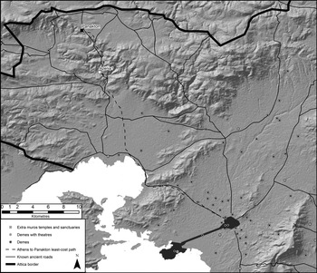
Accessibility of the countryside, enabled by well-built roads, could play an important part in facilitating movement over a large and disparate territory. For instance, the route from Athens to Boeotia via Eleusis typifies the connectivity and diversity of traveller types on routes in Attica (Vanderpool Reference Vanderpool1978; Ober Reference Ober1985, 186; Munn Reference Munn, Lohmann and Mattern2010; Fachard and Pirisino Reference Fachard, Pirisino and Miles2015, 140–4). As illustrated in Figure 5, the route runs north-west from Athens, before turning north at Eleusis; it passes the deme of Azenia where an engineered path continues towards the Skourta plain before entering Boeotia (Vanderpool Reference Vanderpool1978, 238–9). After Azenia, a subsidiary path connects the Panakton fort to the main route (Fachard and Pirisino Reference Fachard, Pirisino and Miles2015, 139–40). The fort is well attested in ancient literature and epigraphy (e.g. Thucydides 5.3.4; Demosthenes 19.326; SEG 46.185; IG II2 1274, 1285), and thanks to this evidence we know that Panakton was occupied by a citizen armyFootnote 37 whose purpose, it seems, was connected to the surrounding landscape (Demosthenes 54.3–5; Munn Reference Munn, Lohmann and Mattern2010, 198). The region around the fort, and in particular Drymos to the east, was claimed by the Athenians in the fourth century bce, and the use of the land was disputed between the Athenians and the Boeotians (Thucydides 5.42.1; Munn Reference Munn, Lohmann and Mattern2010, 192–3). In this instance, the route provided access to the space-time anchors at Eleusis, the demes to the north of Athens and the important fort at Panakton. Depending on the context of its use, or perhaps better yet, the intentions of the traveller, the route could be classed as a ‘military road’, a ‘sacred road’ or a ‘civic road’ (Fachard and Pirisino Reference Fachard, Pirisino and Miles2015, 142–8). This road, then, supported travel for a variety of purposes, and formed important links between sanctuaries, settlements and forts within the landscape.
Known route to Panakton and least-cost path from Athens to Panakton.

Figure 5 allows us to compare the route from Athens to Panakton with a least-cost path to the same destination. Unlike the ancient road, the least-cost path turns north 3.4 km before Eleusis; in general terms, however, the least-cost path follows the ancient route between Panakton and Athens, particularly between Athens and the coast and when the road enters steeper elevations. Since the least-cost path largely mirrors the path of the ancient road, we can infer that the ancient route was a cost-effective means to travel between Athens and Panakton. Therefore, it is possible to conclude that roads facilitated the most direct access to larger sites along their course, like Eleusis, but also that care was taken to provide the least physically demanding route between two points (Fachard and Pirisino Reference Fachard, Pirisino and Miles2015, 141).
Since accessibility between Athens and Panakton was important for the army, we can explore this space-time anchor further by comparing the length of the ancient road to benchmarks of maximum distance and speed travelled by Greek armies in one day (Table 2). The benchmark data for Table 2 is drawn from Herodotus’ description of the Spartan army travelling to Marathon to aid the Athenians in 490 bce: ‘After the full moon 2000 Lacedaemonians came to Athens, making such great haste to reach it that they were in Attica on the third day after leaving Sparta’ (6.120).
Comparative speed and travel times for an army.

Athens and Sparta are approximately 250 km apart; if the army travelled 250 km over three days, it averaged 83.3 km a day. As Table 2 illustrates, to achieve this target the army must have moved quickly for a considerably long period each day. As this was an extreme emergency, it is likely that the army moved at a faster than average speed; studies on the average distances and speeds of armies conclude that 26 km is a more realistic daily maximum distance (Krentz Reference Krentz, Sabin, van Wees and Whitby2007, 161). We can then consider distances between 26 km and 83 km to be the parameters for an army to travel within a day.
The ancient route starting at the north-western wall of Athens to Panakton measures 39 km; from Table 2 we can see that that the journey can be made within five to eight hours depending on the speed of travel, which would perhaps vary depending on the nature of the terrain, the urgency of travel and the individual's motivation. It is also clear that, despite the increased physical effort in traversing the steeper elevations, an army could reach the fort within eight hours.Footnote 38 We have seen already that the surrounding territory was important economically for the Athenians, as the waterlogged plain provided excellent pasturage and extensive forests supporting woodcutting, resin-collecting, beekeeping and hunting (Munn Reference Munn, Lohmann and Mattern2010, 198; Fachard and Pirisino Reference Fachard, Pirisino and Miles2015, 146). Thus, we can estimate the amount of time a group of citizens would be willing to expend, which may have varied depending on the urgency of the travel and the need to reach the fort before a given point in time.
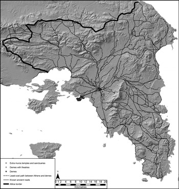
Concerning individual travel, we assume that a traveller could choose from several routes across the landscape to a destination; their choices perhaps reflected the purpose and urgency of their journey too. One of our best types of urgent travel through the countryside comes from those military requirements of the state that required an immediate response from the citizen body. These requirements are demonstrated by the means through which conscripts were notified of their call-up: the monument of the eponymoi in the Athenian Agora was used as an information point for the purpose of spreading news throughout Attica concerning specific individuals.Footnote 39 Athenian roads helped the movement of people, which facilitated their personal, economic, religious or civic objectives; travellers could then act as a means to deliver news, gossip and knowledge to the rural community (Lewis Reference Lewis1996, 70; Lanni Reference Lanni2016, 142). We can infer from this that the state assumed that those who saw the notice would bring the report back to their respective demes. Furthermore, heralds and trumpet calls were used to ensure that announcements were spread throughout Attica (Andocides 1.45; Demosthenes 18.169). It seems, too, that movement of news and persons was multidirectional, and the textual evidence implies that conscripts were expected to travel to Athens to check if they had been called up for military service and also to muster in Athens (Aristophanes, Peace 311–12, 1180–5). For the call-up to be successful, from first conscription to the mustering of the army, not only was the successful transmission of information required, but also the ability for individuals and news to move through Attica efficiently in order for it to reach the maximum number of citizens in the shortest amount of time. Thus, the monument, and also the place for mustering troops, would have acted as a space-time anchor for the traveller by creating a certain point in the landscape that they must travel to before a given time. In order to investigate how the announcement of conscriptions and their response could be achieved, I have modelled routes branching out from demes across the landscape to Athens (Fig. 6).
Known ancient roads and least-cost paths through Attica.

This map helps to visualise possible route choices across Attica, and serves as a comparison with the known ancient routes. In all likelihood, heralds and other state officials would travel along the main roads of the peninsula such as the Sphettia and Astike Hodos, which provided them with the fastest routes possible and also exposure to the majority of settlements, and, resultantly, to the highest number of rural citizens. The least-cost paths do, for the most part, overlap with the known ancient routes, and when the digital paths differ from the model, this owes partly to the fact that these routes are modelled from each deme individually. Since the least-cost paths plot a route directly from each deme, we might assume that these digital routes follow the paths of unknown secondary roads that once connected to larger primary routes.Footnote 40 While it might not be possible to make direct correlations between the course of these least-cost paths and demes not directly on an ancient route, the similarities and differences between the ancient routes and least-cost paths allow us to ask further questions of the data, such as why, in some instances, the ancient roads do not follow the most cost-efficient route. It seems for the most part, however, that most of the landscape could be accessed via these primary routes: the model suggests that the demes along these larger roads may have served as junctions to access all types of site within the countryside.
As such, we can envisage scenarios wherein either demesmen travelled to the main road to hear a herald's announcement or a herald relied upon those travelling towards certain demes to pass on the message. Either way, the formation of junctions that linked primary and secondary routes was of critical importance for the progress of information throughout Attica. Such a network was necessary for the mustering of troops, but for other purposes too: five days’ notice was given before an ostracism (Forsdyke Reference Forsdyke2005, 162-3) to allow citizens to make the journey to Athens; this in itself would have created a specific space-time anchor for those wishing to attend the assembly meeting. Therefore, the generation of least-cost paths and their comparison to known ancient routes help us gain greater insight into the communicative potential of the Athenian road network.
THE PHYSICAL AND TEMPORAL COST OF MOVING THROUGH ATTICA
In addition to the information gleaned from studies of ancient Attic routes and their comparison to least-cost paths, we can gain greater insight into the physical and temporal cost of such journeys through the generation of a path-distance model of the ancient Athenian landscape measured in time. We can compare these estimates using the parameters for the kinds of load, speed and transport for ancient Greek and Roman contexts as illustrated in Table 3 (Bevan Reference Bevan, Dunn and Mahoney2013, 3–24). The aim of this is to gain further insight into the realities involved in travel through the ancient Athenian landscape with the purpose of understanding the extent to which the duration and difficulty of travel impeded movement through Attica.
A selection of ancient performance estimates (Bevan Reference Bevan, Dunn and Mahoney2013, 6).

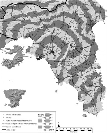
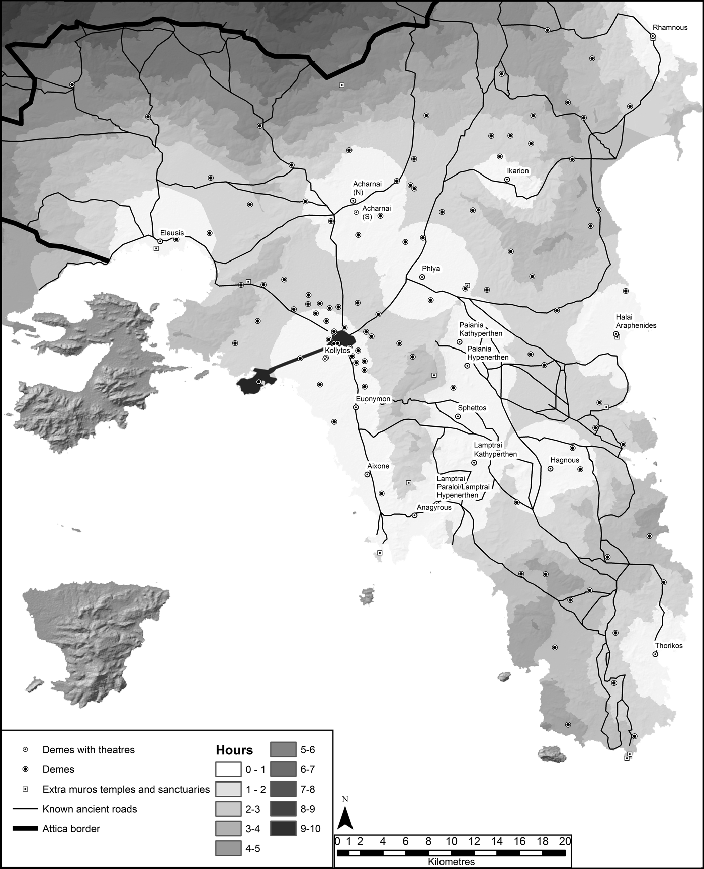
In Figure 7, each halo equals one hour of travel time measured at a walking pace of 5 km per hour. Based on this model it takes approximately 11 hours to walk from Athens to Sounion and two to three hours to walk to Acharnai. Of course, these estimates do not take into account variables such as vegetation, weather, season or stopping for breaks.Footnote 41 Nevertheless, this map illustrates in real terms the effort required to travel through Attica in a way that was meaningful to the ancient Athenian, demonstrating both the diversity of the Athenian landscape and the physical effort needed to move across it. It is clear that areas with steeper elevations have a higher time-cost and the distance travelled is less than on the gentler slopes and plains of the peninsula. For example, it takes approximately one hour to walk the north-western slope of Mount Hymettus to the summit. This section of the route measures 1.7 km, meaning that the average walking speed has fallen below 2 km per hour, reflecting the steep terrain of the mountain.
Distance in hours from Athens along with known ancient roads and least-cost paths.

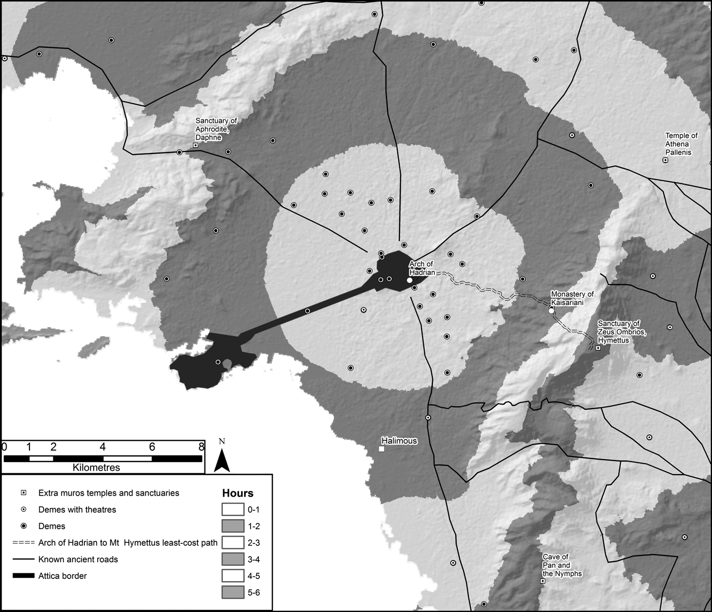
We can compare these estimates of travel time to Dodwell's description of a journey to the summit of Mount Hymettus (Fig. 8) on 8 October 1805 (Dodwell Reference Dodwell1819, 484). Dodwell writes that he and his companion set out on horseback from the Arch of Hadrian and arrived at the Monastery of Sirgiani (Kaisariani) at the foot of Mount Hymettus within 45 minutes.Footnote 42 The least-cost path (Fig. 8) between the arch and the monastery measures 6.7 km, which means that they travelled at a speed of 8.9 km per hour; this is compatible with the benchmarks of a riding horse's walking pace listed in Table 3. Once at the monastery, they broke into the storerooms, helped themselves to a meal and bedded down for the night. On the following day they set out to the summit on horseback. Dodwell claims that it took them one hour and 40 minutes to reach the summit from the monastery. This time, compared to the 2.7 km length of the least-cost path, suggests that the pace had slowed to 1.62 km per hour, illustrating the difficult climb faced by the men and their mounts. From Dodwell's account, it appears that the ascent was steep and difficult, but achievable owing to the experience of the horses. Gell (Reference Gell1819, 93–9) seems to have taken a similar route (he, too, started out from the monastery), and, noting that it was not feasible to make the summit on horseback,Footnote 43 hiked to the summit on foot. He remarks that he made the summit in one hour and 10 minutes. This suggests that horses were not the most efficient means of travel to the summit, perhaps owing to the rugged and difficult terrain. This helps bring into focus the previous assertion that a traveller's choice of transportation had a direct impact on the nature and experience of travel.
Least-cost-path route from the Arch of Hadrian to the summit of Mount Hymettus via the Monastery of Kaisariani.

Turning to the ancient sources, the only detailed account of a deme assembly is Demosthenes’ Against Eubulides in which the speaker offers an account of the disenfranchisement of a deme member. Although the assembly was held in Athens, the plaintiff (Euxitheus) and fellow demesmen resided in the deme of Halimous some 35 stades (roughly 6.5 km) south of Athens. The plaintiff alleged that he had been unjustly struck off the deme's citizen register owing to personal hostility between him and the defendant, Eubulides. One aspect of his defence is the claim that not all demesmen were present for his vote, since by the time the plaintiff's citizenship was to be voted on it was dark and the majority of the demesmen had returned home (Demosthenes 57.9–10). He complains that his case should have been voted on the following day when the assembly was to reconvene, but the speaker claims that Eubulides used the reduced numbers to his advantage and pushed for the vote that evening (Demosthenes 57.15–16).
What is of particular interest to us is that the demesmen travelled to Athens for the assembly and, more importantly, travelled back to Halimous with the intention of returning to Athens the following day.Footnote 44 In this case, it seems that the physical and temporal cost of travel, imposed by the space-time anchor of the deme assembly, was less than that required to source lodgings within Athens. We might assume that his fellow demesmen had left before the voting was finished owing to the difficulty of their journey, which required additional time and/or greater daylight. However, the speaker claims that the voting began late in the evening, and when his name was called it was already dark (57.9). Thus, we can assume that the majority of the demesmen had made their journey home in the fading light of the day: lack of daylight may not have hindered travel. From Figure 8, it seems that the terrain between Athens and Halimous is quite flat in relation to other areas of Attica, and the city centre is within a two-hour walk/wagon ride from the deme. Consequently, the terrain to the south of Athens may not have posed an obstacle to travel. In addition, the potential dangers of travelling at dusk were somewhat mitigated by the likelihood that the majority of the demesmen travelled together through a reasonably well-populated area of Attica.
To investigate this further, we can compare the descriptions of Dodwell, Gell and Hobhouse of the route from Vari (further south of Halimous) to Athens (Dodwell Reference Dodwell1819, 556–7; Gell Reference Gell1819, 89–92; Hobhouse Reference Hobhouse1833, 407–10). All three authors note that the terrain before one reaches the plain around Athens is reasonably difficult to travel over; however, once the road opens onto the plain, none of the authors remarks upon the nature of the terrain or the road. Indeed, neither Hobhouse nor Gell mention the landscape; Dodwell writes of the various archaeological traces but remains silent on the terrain. From Figure 8, we can see that Halimous, in comparison to other demes, is relatively close to Athens, and, from Dodwell's description of his ride from the Arch of Hadrian to the slopes of Mount Hymettus, we might assume that one could quite quickly travel across this gently sloping ground with little physical effort.
It seems, in the case of the plaintiff in Against Eubulides, that the concern over the journey home may not have been a factor in the deme members’ decision to leave the assembly before the plaintiff's vote; perhaps, more importantly, the outcome of the vote, despite the plaintiff's protestations that it was rigged, would have remained the same.Footnote 45 In this scenario, we have a case of travellers coming and going from Athens within a day, and, significantly, it appears that the need to return home impinged on their ability to stay later. Consequently, we can set a potential benchmark travel time of two to three hours one way for a space-time anchor requiring a round-trip in one day, after which it ceases to be feasible for a traveller to make a return journey on foot.Footnote 46
A journey to Athens was not the only opportunity available for a rural Athenian to engage in civic activity. Figure 9 illustrates the location of known deme theatres that provided similar opportunities for inhabitants of dispersed settlements to come together for civic,Footnote 47 economic and religious functions (Thucydides 8.93.1; Whitehead Reference Whitehead1986, 123–4, 218–22; Paga Reference Paga2010, 367, 380–1). These sites could support the civic organisation of the individual deme and also provided opportunities for gatherings of members of trittyes within phylai (Paga Reference Paga2010, 378). Jessica Paga argues that deme theatres were evenly spread throughout Attica, with the intention of having one theatre for each trittys and phyle (Reference Paga2010, 378).Footnote 48 Whatever the trittys’ civic role, for Paga, the distribution of these theatres served not only the deme but also the communities of demes in the surrounding territory (Reference Paga2010, 380). Thus, deme theatres acted as spaces that facilitated multiple types of activities (Reference Paga2010, 381), which in turn needed to be reached by the wider community.
Distance in hours from deme theatres.

Therefore, we can consider deme theatres to be another form of space-time anchor, and, for connectivity between deme theatres and surrounding demes to be effective, we can assume that they were accessible within the two-to-three-hour timeframe proposed above. In this scenario (Fig. 9), we can envisage inhabitants of demes located in the countryside around deme theatres travelling to such sites to fulfil their objectives.Footnote 49 It seems in some instances that demes to the north of Attica and to the far south were at the limit of this benchmark. For northern demes, this likely was a result of the mountainous nature of the landscape, which would slow travel but perhaps not impede it. To the south-west, however, the pattern suggests that demes were less well connected than those in the centre and north of Attica. It was possible, then, that decisions to travel to deme theatres varied depending on their location within Attica. Therefore, on the one hand, this model serves to highlight the potential connectivity of the Athenian landscape and allows us to visualise the landscape's communicative potential,Footnote 50 but, on the other hand, it also seems that some areas of Attica were more accessible than others. This does not necessarily mean that individuals in more remote areas were cut off from Attic institutions; rather, it suggests that travel for these individuals came at a higher physical cost.
It is clear that the greater the intended travel distance, the more physically demanding the journey.Footnote 51 We can assume that there were several reasons for groups and individuals to embark on mid- to long-range overland travel, such as participation in civic institutions, pilgrimage, trade and military service. Scholarship has already identified several ancient roads along the borders of Attica that supported movement of peoples for reasons beyond military purposes (see discussion in Fachard and Pirisino Reference Fachard, Pirisino and Miles2015). Based on the preceding discussion, we can assume that these roads may have supported a considerable amount of traffic, and, as a result, were well-built and energy efficient.Footnote 52 For example, a route from Oropos via Dekeleia is not only cited for its strategic military importance but because it also acted as a ‘carriageable’ route to transport grain from Euboea (Thucydides 7.28.1; Fachard and Pirisino Reference Fachard, Pirisino and Miles2015, 145).Footnote 53
Dodwell recalls travelling on horseback along sections of another ancient road ‘cut in the rock’ between the modern town of KhasiaFootnote 54 and the fort at Phyle (Dodwell Reference Dodwell1819, 503). He writes that the fort was eight hours from Athens and that the journey between Khasia and the fort at Phyle took one hour and 15 minutes. The ancient route from Khasia to Phyle measures 8.7 km, suggesting that Dodwell travelled at approximately 7 km per hour; this is a somewhat reduced walking pace on horseback, but not as drastically reduced as Dodwell's journey to the summit of Mount Hymettus. We can compare this information to Hobhouse's journey travelling from Thebes to Phyle via the Skourta plain (Reference Hobhouse1833, 284–7). Approaching the mountain from the north, he recalls that the path was very steep in places and notes that the pace was slow going until the fort at Phyle was reached. Describing his descent from Phyle to the plain of Athens, a journey of one hour and 30 minutes, Hobhouse writes that the rocky path zig-zagged; it is likely, on the basis of his description of the route, that he travelled on the same path as Dodwell.Footnote 55 It seems that the design of the ancient route to/from the plain of Athens to Phyle allowed access to mountainous settlements.
Another route, this one between Athens and Oropos via the deme of Aphidna, is mentioned by the third-century bce author Ps-Dikaiarchos, who describes it as: ‘To Oropus via Aphidna and the temple of Zeus Amphiaraus, about a day's journey for a pedestrian without baggage, uphill all the way; but the abundance of inns permits frequent refreshments and rests.’Footnote 56
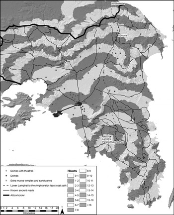
This seems to be the route that provided access to the Amphiareion at Oropos for Athenian suppliants (Dillon Reference Dillon1997, 37). Participation of Athenians at the sanctuary is recorded in epigraphic accounts and in Aristophanes’ fragmentary play Amphiaraus, which is set within the sanctuary. While we do not have the complete play and it is difficult to add context to the existing fragments, one fragment – ‘I'm from Lower Lamptrai’ (Λαμπτρεὺς ἔγωγε τῶν κάτω: Henderson Reference Henderson2008, fr. 27) – suggests that individuals may have travelled a considerable distance to make use of the sanctuary. Admittedly, it may not necessarily be the case that the speaker travelled directly from Lower Lamptrai to attend the sanctuary, as the husband and wife protagonists of Amphiaraus had travelled from Athens. Instead, the speaker may have lived much closer to the sanctuary, but, for the sake of testing the realities of long-distance travel through Attica, it is worthwhile using this as an example to elaborate on further using the distance model (Fig. 10).
Distance in hours from Lower Lamptrai and least-cost path to the Amphiareion.

From the model, it seems that there is no direct route from Lower LamptraiFootnote 57 passing Aphidna and onward to the sanctuary. However, the least-cost path suggests a route through the centre of Attica that makes contact with a number of ancient roads before joining up with the road linking Athens to Aphidna.Footnote 58 It seems unlikely that an individual travelling from Lower Lamptrai to the Amphiareion would have travelled to Athens first unless they needed to. While it is not impossible for a traveller to cut directly across Attica using (unknown) secondary paths to Aphidna, if the traveller had any form of baggage, based on the least-cost path, it is likely that they would have moved further to the east to follow one of the established routes through the centre of the peninsula before linking-up with the main route via Aphidna north of Athens. In total, a journey between Lower Lamptrai and the Amphiareion would take approximately 14–15 hours each way.
Ps-Dikaiarchos claims that it takes a day to travel to the Amphiareion from Athens ‘uphill all the way’; we can see that travelling from Athens it takes approximately five to six hours to reach Aphidna and nine to 10 hours to reach the Amphiareion. It seems from the model that the majority of the journey would be over reasonably accessible terrain, and it is not until the mountainous north of the territory and along the border that the landscape becomes more physically demanding. The distance between Athens and the Amphiareion along the known ancient road measures approximately 42 km. If the model is accurate, this means that a traveller averaged a pace of 4.2–4.6 km an hour travelling on foot, which is slightly lower than the average 5 km an hour on flat ground. It seems, then, that this route between Athens and sanctuary, at least, was relatively easy going; Ober, who has walked the ancient route, corroborates this when he notes that ‘the route by Aphidna into the Athenian plain is quite [physically] easy and may have been carriageable’ (Reference Ober1985, 115).
Like the example from Demosthenes’ Against Eubulides, which helped set a return journey benchmark of two to three hours each way, perhaps we can apply the same principle to the example above, and use this to set a one-way benchmark for a day's journey across Attica. Concerning maximum distances achieved in one day, the benchmarks for travel, time and distance set for an army (Table 2), discussed earlier in this paper, determined that the distance a citizen army might achieve in a day was in the range of 26–83 km. We have similar estimates if we calculate time, distance and speed from Socrates’ recollection that one can walk to Olympia from Athens within five to six days (Xenophon, Memorabilia 3.13.5). If we say that Olympia is approximately 300 km from AthensFootnote 59, to reach Olympia within five to six days an individual would have to cover 50–60 km a day. At an average walking pace of 4–5 km per hour, this would require 10–15 hours of continuous travel, which fits well with the time estimates for journeys between Athens and the Amphiareion (nine to 10 hours) and Lower Lamptrai and the Amphiareion (14–15 hours) discussed above. On average then, we can posit a window of 10–15 hours of travel achievable within a day. This window gives the model a certain amount of flexibility and allows for differences in the physical capabilities of the traveller, the means of travel and the impact of weather and seasons on travel. As a result, these types of estimates allow us to frame the experience of travel for the individual and gain a sense of the amount of time needed to reach a set space-time anchor in the landscape.
Of course, in all likelihood, extended periods of uninterrupted walking, riding or driving a cart would be strenuous; perhaps one of the most pressing concerns for an individual wishing to make a journey longer than three hours would be sourcing rest and refreshment. Ps-Dikaiarchos recalls that travellers could stop off at inns to rest and receive refreshments during their journey north. The textual evidence suggests the existence of kapēleia (taverns) within urban settings, which may have provided a stopping point for those making mid- to long-range journeys.Footnote 60 However, the perception presented in texts is that taverns were linked with social degeneracy (Kelly-Blazeby Reference Kelly-Blazeby2006, 26). Thus, it is difficult for us to know who might be willing to stop at a designated tavern, and indeed the differences between taverns and other types of establishments that might not be suitable for a traveller to stop at.Footnote 61
The identification of taverns in the archaeological record is equally difficult and primarily dependent on the ceramic repertoire, which often bears some similarities to domestic household assemblages.Footnote 62 Yet, an assemblage from a site that served a commercial purpose, such as a tavern, inn or brothel, may contain greater amounts of drinking ware and commercial storage ware than one from a ‘typical’ domestic setting (Trümper Reference Trümper, Ault and Nevett2005, 121–2; Ault Reference Ault, Glazebrook and Tsakirgis2016, 93; Lawall Reference Lawall, Glazebrook and Tsakirgis2016, 73–4). In rural contexts, however, it is much more difficult to identify such a variation in the types of ceramic repertoires, owing to the limited number of fully excavated and published examples. The lack of archaeologically documented examples of such settings does not mean, however, that they did not exist in some form or another, especially in larger settlements throughout Attica. It does mean, though, that it is very difficult for us to describe with any certainty the workings of such sites and their frequency in the countryside. Equally, there is the possibility of opportunistic moments when travellers could purchase food and drink from rural residents or potentially hire a spare bed for the night. Although the example presented in Ps-Xenophon (Athenian Constitution 1.17–18) describes the exploitation of Athens’ allies by renting rooms to them in and around Athens, it does at least highlight the possibility that an enterprising individual might have been willing to hire space out to a traveller.Footnote 63
While it is difficult to pinpoint the existence of taverns and other places to seek rest and refreshment beyond the larger urban centres, the likely presence of taverns, or even inhabitants who were willing to provide rest and sustenance, creates another space-time anchor on the individual's journey to their ultimate destination. Furthermore, it also offers an opportunity for connectivity and communication across communities and between individuals who may be travelling in the same direction or towards the same destination. It seems that, in these scenarios, any perceived difficulty in the journey could have been reduced by stopping at known and recognisable rest points. Therefore, any concerns regarding the distance and duration of travel were eased somewhat by effective means of transport, an efficient road system that allowed one to travel over difficult terrain without too high a time cost or physical exertion and opportunities for rest and nourishment.
CONCLUSION
This paper began by recognising that research has brought to light the multiple social, economic and civic institutions available for the Athenian to engage with throughout Attica. While there is convincing evidence that some settlements (like Acharnai) and micro-regions (like the Marathonian Tetrapolis) had specific social organisations and to an extent were self-sufficient,Footnote 64 there is equally convincing evidence indicating that individuals and groups made journeys beyond their local area with the intention of engaging with civic, economic and cult practices. Owing to this research, new avenues of enquiry have been opened and lately attention has turned to the experience of travel and the importance of roads in fostering social connectivity.
For the individual to engage with these institutions, we may assume that participation necessitated travel across Attica, but until this point there has been little we could say about the journeys themselves and the experiences of the individual. This paper contributes to recent conversations with the primary goal of testing the hypothesis – using computational analyses to model historical examples of journeys – that travel and general mobility of the population occurred throughout Attica. A secondary goal is to understand the experience of travel for the individual by discussing the modes and nature of travel, and to draw conclusions about how variations of these elements may have affected travellers’ choices before and during a journey. These analyses are framed by the concept of time geography, which allows us to place the traveller at the centre of the model and understand the experience of travel from their perspective. Furthermore, measuring distance in time provides an opportunity for us to describe journeys and routes in a manner meaningful to the traveller. Equally, by identifying space-time anchors that help define the duration and destination of a journey, we are able to posit better-founded conclusions about direction of travel, means of travel and route choice. This complexity, and conscious awareness of travel and the considerations of making a journey, is something that this paper has sought to test and model.
The outcome of this study tells us more about the experience of travel for the individual; it is clear that the Athenian landscape did not pose an insurmountable obstacle for travel, although it may have made for physically demanding journeys. Equally important is the fact that individuals did move efficiently within micro-regions, through the countryside and across Attica. Thus, insight into the nature of Athenian travel enables greater awareness of how travel was achieved, as well as how individuals engaged and interacted with their surrounding landscape. It is undeniable that the Athenian infrastructure and the landscape of Attica played significant roles in daily life. From the scenarios presented here, it is clear that, for individuals to undergo any journey, they must have been aware not only of their immediate landscape, but the landscape of their entire journey. We can envisage travellers engaging in dialogue, not only with their travelling companions about how best to achieve the outcome of their journey, but also with the landscape as an active participant in the needs of the individual. As such, the needs of the individual and the accessibility of the landscape worked in tandem to achieve the outcome of the journey. The remains of the Athenian road network and the hills, valleys and plains that make up the Athenian landscape played an ever present and central part in an individual's lived experience. The outcome of this study illustrates that it is important to understand not only how distinct sites supported societal connectivity, but also how the roads and the landscape provided an experience in themselves, which in turn fostered and supported the Athenian social landscape.
ACKNOWLEDGEMENTS
I would like to thank participants in the research reading group of the Classics, Ancient History and Archaeology Department at the University of Birmingham, who have given useful feedback on this paper; in particular, I offer thanks to Andrew Bayliss, Leslie Brubaker, Dan Reynolds, Dominik Maschek, William Mack, Gareth Sears and Roger White. My sincerest gratitude goes to Peter Liddel, John Bintliff, Sylvian Fachard, Mark Munn, Robin Osborne and the anonymous reviewers whose comments have greatly improved this paper. My thanks go also to Catherine Steidl and Evan Levine for their stalwart assistance. All errors are my own.
APPENDIX: GLOSSARY OF TERMS AND METHODOLOGY
Glossary of terms
Anisotropic: ‘dependent on both the direction of travel and any directional attributes (e.g. aspect) of individual map cells’ (Connolly and Lake Reference Connolly and Lake2006, 289).
ArcGIS 10.1: Geographical Information Systems computer programme developed and licensed by ESRI.
ASTER v2: open source 30 m DEM developed by NASA and METI. Available for download through the USGS EarthExplorer portal at https://earthexplorer.usgs.gov/.
Digital Elevation Model (DEM): ‘Digital model of the elevation of the earth's surface’ (Connolly and Lake Reference Connolly and Lake2006, 291).
Cost-surface model: ‘A model of the cost of moving from a specified origin to one or more destinations. The cost recorded at the destination(s) is that incurred when following the least costly route from the origin, as computed by applying a spreading function to a cost-of-passage map’ (Connolly and Lake Reference Connolly and Lake2006, 289).
Cost-distance raster: ‘determines the shortest weighted distance or accumulated travel cost from each cell to the nearest source location … A source and a cost must be created. Cost distance is the prerequisite for finding the least cost path or corridor’. The accompanying cost-backlink raster ‘defines the neighbour that is the next cell on the least accumulative cost path to the nearest source’ (ESRI 2018a).
Cost-of-passage map: ‘A raster map that models the energetic, time, or other cost of travelling across each map cell’ (Connolly and Lake Reference Connolly and Lake2006, 291).
Digitising: ‘Generally, the process of converting conventional paper maps and images into a digital form. Among GIS practitioners the term is often used to refer specifically to those methods that produce vector rather than raster output’ (Connolly and Lake Reference Connolly and Lake2006, 291).
Georeferencing: ‘The process of placing spatial data (such as remote-sensing imagery or digitised paper maps) in its correct geographic location by transforming it to fit an appropriate coordinate system’ (Connolly and Lake Reference Connolly and Lake2006, 293).
Least-cost path: ‘A route that minimises the total cost of moving between two locations on a cost-surface map’ (Connolly and Lake Reference Connolly and Lake2006, 294).
Path-distance model: ‘Calculates, for each cell of a raster, the least accumulative cost distance to the nearest source, while accounting for surface distance and horizontal and vertical cost factors’ (ESRI 2018b).
Raster: ‘Matrix of cells organised into rows and columns, each cell contains a value representing information such as temperature, elevation, slope, etc.’ (Connolly and Lake Reference Connolly and Lake2006, 298).
Shapefile: ‘A vector data storage format for storing the location, shape, and attributes of geographic features’ (ESRI 2018c).
Slope raster: ‘Calculates the maximum rate of change in values (elevation) from neighbouring cells in a raster grid’ (Connolly and Lake Reference Connolly and Lake2006, 298).
Spatial Analyst: ‘ArcGIS toolbox which provides a set of spatial modelling and analysis tools for raster and vector datasets’ (ESRI 2018d).
Tobler's hiking function: estimates the time in hours of moving across a raster based on slope (Tobler Reference Tobler1993).
Vector: ‘A vector represents spatial data using points, lines, and polygons (Connolly and Lake Reference Connolly and Lake2006, 300).
Methodology
The tools used here have become staples in archaeological research; the application, methodologies and criticisms of using computational modelling to reconstruct past environments have been addressed in several publications (e.g. Wheatley and Gillings Reference Wheatley and Gillings2002; Connolly and Lake Reference Connolly and Lake2006; Farinetti Reference Farinetti2011; Bevan and Lake Reference Bevan and Lake2013). Spatial data for demes were downloaded as vector point shapefiles from https://pleiades.stoa.org/, and their location accuracy was recorded from https://darmc.harvard.edu/. The course of known ancient roads and the border of Attica were digitised and georeferenced from paper maps in Fachard and Pirisino Reference Fachard, Pirisino and Miles2015, 140 and Kakavogianni Reference Kakavogianni and Korres2009, 184. The ASTER v2 30 m resolution DEM of Attica forms the basis of the topographic data; it was from this dataset that all other raster outputs were created. This vector point and polyline data, along with the raster elevation data are the baseline datasets for these analyses.
For both sets of models it was necessary to create a slope raster and anisotropic cost-distance raster with the accompanying cost-backlink raster. All models were created using the default parameters within the cost-distance and path-distance toolboxes in ArcGIS 10.1. I chose to use the path-distance method because it is more sophisticated than most default cost-surface methods in adjusting for direction of travel across a slope. The path-distance tool models the cost, in this analysis measured in time, of moving through the landscape (Conolly and Lake 2006, 215) by assigning ‘friction values’ using Tobler's hiking function (Tobler Reference Tobler1993), which estimates time in hours to cross a cell of a slope raster. In this output, for example, if a slope has a value of three, it takes three hours longer to journey across it than a slope with a value of one. Two cost-of-passage models were created, one starting from the walls of Athens and the other from deme theatres.
The same anisotropic cost-distance and accompanying backlink rasters were used to create the least-cost paths. This is a necessary step given that the cost-distance rasters consist of a matrix of cells ranked on their difficulty to traverse. For this analysis the starting point for the cost-distance rasters was Athens. In order to generate a least-cost path, the programme calculates the path of least resistance from demes to Athens using the cost-distance and cost-backlink rasters. It is at this point that the model generates a path that is the most cost-effective route through the cost-distance raster. For this paper least-cost paths were created from demes to Athens, from Athens to Panakton, from the Arch of Hadrian to the summit of Mount Hymettus and from Lower Lamptrai to the Amphiareion.