
This article draws together excavation, survey and historical sources to discuss the transition from the last centuries of prehistory or ‘Late Iron Age’ (first to mid-sixth centuries CE), to those immediately predating the spread of Angkor-style ceramics and ideas, or the Pre-Angkorian period (mid-sixth to ninth centuries CE), in the Upper Mun River Valley (UMRV) of northeast Thailand (fig. 1). The timing, nature, and indeed terminology of this transition are a source of much contention (table 1). This article addresses key questions emerging from this debate, including: What happened to strong Late Iron Age communities of the Upper Mun entering into the fourth to ninth centuries CE? What role, if any, did neighbouring polities in central Thailand and the Tonlé Sap region have in the UMRV's development during this transition?
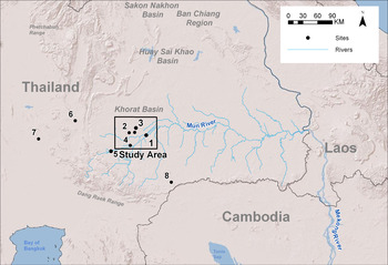
Location of study area within mainland Southeast Asia. Sites discussed in this article: 1. Phimai, 2. Non Ban Jak, Non Muang Kao, and Noen U-Loke, 3. Prasat Phon Songkhram, 4. Prasat Hin Phanom Wan, 5. Muang Sema, 6. Sri Thep, 7. Chansen, 8. Khao Plai Bat

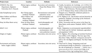
Pre-PSKAS surveys and projects in northeast Thailand

Source: After Chureekamol O. Eyre, ‘Social variation and dynamics in metal age and protohistoric central Thailand: A regional perspective’, Asian Perspectives 49, 1 (2010): 43–84.
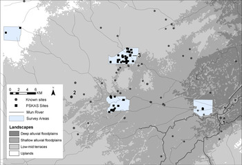
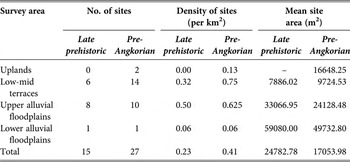
We present new data from recent intensive pedestrian surveys on this period conducted by the Phon Songkhram Archaeological Survey (PSKAS) team. The surveys were conducted over the dry seasons of 2012 to 2014 in a random sample of common UMRV landscapes, including uplands, low-mid terraces, upper alluvial plains, and deep alluvial floodplains (fig. 2).Footnote 1 The survey was intended as a semi-independent project, providing high-resolution, intermediate-scale settlement data for ongoing excavations by the Society and Environment before Angkor (SEBA) project, with the aim of understanding changing patterns of landscape use in the UMRV.Footnote 2 In total, the survey revealed 1,000 temporally diagnostic artefacts: 172 artefacts within 15 sites were attributed to the Late Iron Age and 174 artefacts within 27 sites to the Pre-Angkorian period (fig. 2 and table 2).Footnote 3
Close up of study area with previously known sites from all time periods (grey circle) and those found during PSKAS (black square): 1. Phimai, 2. Non Ban Jak, 3. Prasat Phon Songkhram

PSKAS site statistics

Upon integrating the new survey data with previous research it becomes readily apparent that the fourth to ninth centuries CE were a pivotal period for the UMRV. This was a time of transformation both in terms of the nature of a ‘settlement’ and the wider use of the landscape. Large Late Iron Age occupation and burial mounds contain evidence of gradual (as opposed to rapidly introduced) transition into the early historic period during the fourth to sixth centuries CE, most notably at Noen U-Loke, Phon Songkhram, Non Ban Jak, and Non Muang Kao. We cautiously argue that these three centuries might be best termed ‘proto-historic’. The people of the UMRV were only peripherally engaged with the wider historical world attested by inscriptions and other writings in the broader region. Ceramic styles, interment rituals, and encircling earthworks at these burial mounds all display evidence of adaptation during this time. This signifies the continuation of wet-rice producing Late Iron Age centres in the UMRV, up till — and in the case of Phon Songkhram village, beyond — the ninth century CE.
However, when we examine settlement patterns associated with the later spread of ‘Indic-style’ artefacts and features into the UMRV, two patterns emerge. Temples (primarily brick), monuments (stupas), sema stones, and large administrative complexes appear to be strongly aligned with the linear, riverine trade network. ‘Lay communities’, on the other hand, continued to maintain a presence in Late Iron Age wet-rice producing hubs, cautiously expanding across the high terraces and into the uplands, approaching tributaries of the Chi River Basin to the north. These communities reduced in size by a third, dividing into small, localised clusters of settlements (predominantly 50–200 m in diameter). Timing is key to understanding the relationship between the large floodplain centres, these new communities on higher ground, and the construction of monuments and temples along riverine corridors. There is a need to further refine the exact timing of architectural, inscriptional, and archaeological features specific to the UMRV, and wider mainland Southeast Asia, ideally with absolute dating.
Another key factor in the development of settlement patterns, brought to light in this article, is the continued role of the UMRV itself. Periods of growth and expansion in neighbouring regions of mainland Southeast Asia have been well documented during the early first millennium CE, and certainly these emerging powers were in contact with UMRV inhabitants. Many of these polities and emerging states are said to have arisen from ‘hierarchical’ chiefdoms via a linear, ranked ‘urban-driven’ trajectory of social and economic development. Alternatively, others argue for ‘heterarchical’ foundations, which emphasise the development of multiple, discrete settlement organisations simultaneously.Footnote 4 Consider, for example, Chureekamol Onsuwan Eyre's evidence for a dual approach to settlement organisation in the Upper Chao Phraya Valley, central Thailand: an internally ‘loose’ organisational structure, which emphasises large village production centres of variable size, balanced by a more cohesive, external socioeconomic-driven identity.Footnote 5 In this article, however, we argue that the relatively arid, unpredictable Mun River system somewhat limited and delayed full integration with an external power and the development of a large, integrated polity (as in central Thailand or the Mekong Delta). However, this is only a limitation if we view the appearance of an integrated state as some sort of teleological endpoint. We argue here that a focus on gradual, local adaptation of ideas from the west and southeast, and community ‘complexity’ (in the operational sense), provided strength and ‘resilience’ for UMRV communities during the region's volatile sociopolitical and environmental transition from prehistory to history.
Background to the UMRV
The Upper Mun River Valley constitutes the upper (western) catchment of the Mun — a major tributary extending from the Phetchabun Mountains that separate northeast and central Thailand — and continues east until its confluence with the Mekong in southern Laos. The UMRV is particularly dry and salt-affected, with unpredictable seasonal rains. Paleoenvironmental records suggest the region has been volatile and often water-scarce for at least the last three millennia.Footnote 6 Yet the UMRV's location makes it critical to the development of wider mainland Southeast Asia (fig. 1): in combination with passes through the surrounding uplands, it is an obvious route that connects the region from east to west, as well as south to the Angkor heartland.
Previous research includes regional aerial and pedestrian surveys, excavations, and historical research, and is summarised in table 1. While recent decades have seen much work on UMRV prehistory, the transition from Late Iron Age to the earliest ‘Indianised’ Pre-Angkorian societies has received less consideration.Footnote 7 Attempts to understand the mid-sixth to the ninth centuries CE in northeast Thailand are hampered by poor articulation between historical records, inscriptions, local architectural remains, and archaeological evidence of occupation.Footnote 8 This disconnect is, in part, caused by the lack of overlapping chronological frameworks, or reference points with which different data sources can be related, and the lack of common recording techniques and research priorities.Footnote 9 It is also, perhaps, a limitation of a focus on large-scale site-based excavation. The surface artefact distributions recorded during the landscape-based site surveys discussed here reveal constant movement of settlement centres over time within large prehistoric and historic sites in the UMRV. Such micro-shifts, and thus the complete sequence of occupation at any one site, are not likely to be revealed by one or two (albeit large) excavation squares. Despite these issues it is clear, however, that the fourth to ninth centuries CE were a significant, complex, and rather ambiguous era in the UMRV which deserve further attention.Footnote 10
PSKAS is the first large-scale systematic pedestrian survey of both prehistoric and historical surface artefacts in the UMRV in the last 29 years (tables 1 and 2).Footnote 11 This article will discuss settlement trends of the Late Iron Age and Pre-Angkorian period individually, before using individual site case studies to explicitly examine the transition between these two periods in the fourth to sixth centuries CE.
Late Iron Age in the UMRV
The Late Iron Age (first to the mid-sixth centuries CE) in the UMRV is concordant with Iron Ages 2 and 3 at Ban Non Wat and Noen U-Loke (fig. 1).Footnote 12 Fibre-tempered ‘Phimai Black’ ceramics are characteristic of this period in the UMRV. The primary evidence of prehistoric settlement generally, and of the Late Iron Age specifically, are the large habitation mounds, often found with encircling earthworks, close to waterways, and with large numbers of elaborately interred burials. These sites are visible in aerial photographs, and have been identified in large-scale reconnaissance surveys; a few have also been excavated.
An initial examination of such evidence indicates that Late Iron Age sites were restricted to upper alluvial floodplains and lower terraces in the UMRV. The Khorat Basin Archaeological Project (KBAP) in the Phimai region in the early 1980s revealed a clear preference (84 per cent) for Classic Phimai Iron Age sites (second century BCE–third century CE) to be located in these environments. Twenty-six of these sites were fully or partially ‘moated’.Footnote 13
The PSKAS results reveal a similar distribution of Late Iron Age sites, within our study area (fig. 2). However, it should be noted that the PSKAS Late Iron Age only overlaps the latter half of the KBAP Classic Phimai Phase, or the first to mid-sixth centuries CE. No Late Iron Age sites were found in PSKAS area A, in the dry, sandy uplands. Late Iron Age occupation appeared to be concentrated in the modern alluvial floodplains (53 per cent of the sites), second only to the low terraces (40 per cent). The further we enter the modern floodplains, the larger and denser both KBAP and PSKAS sites tend to become. Ban Tamyae is a prime example.Footnote 14 Located less than 4 km from Phimai town, Ban Tamyae is a large, dense, and rather isolated site. Artefacts recovered from Ban Tamyae account for some 16.28 per cent of all the Late Iron Age diagnostic artefacts (n = 28) recovered during the study.
The distribution of Late Iron Age sites appears to display a strong relationship with the anatomising channel network in the UMRV, which developed in the early centuries of the first millennium CE. When examining known ‘moated’ prehistoric sites of the UMRV, William Boyd noted that they clustered ‘within the approximately one-fifth of the floodplain in which the former rivers flowed’.Footnote 15 When environmental conditions became drier and more volatile (mid-fourth century BCE), fossil channels were adapted to encircle mounded sites, whilst remaining connected with a larger fossil river network. The PSKAS results found that the Iron Age sites maintained a significant relationship with both modern perennial river systems and fossil channel networks. This, however, is likely to relate to the presence of the modern Huai Yai River passing through the elevations where anatomising channels developed, within the study area.
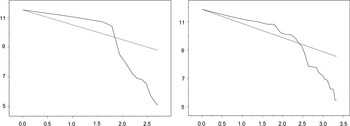
We can use the relative ranking of settlement sizes, or the rank-size curve, to gain an understanding of the physical, and by proxy sociopolitical, organisation of Late Iron Age sites in the UMRV. David Welch has argued that Classic Phimai phase settlement patterns were indicative of a two-tiered hierarchy — large village/town centres and clusters of smaller satellite settlements. Large mounds, containing a high density of Phimai Black ceramics and/or burials, formed the local centres, or marketplaces. These local centres, Welch and Judith McNeill argued, continued to form the focus for settlement patterns well into the ‘Lopburi period’ (tenth–thirteenth centuries CE).Footnote 16 The Late Iron Age rank-size curve in the PSKAS study, however, is decidedly convex, with many comparable (mid to large) sized settlements (fig. 3). There is irregularity and variation in the size of these ‘local centres’. Such a lack of uniformity suggests limited integration of people and communities at a regional scale. It is probable that there were multiple settlement systems within the UMRV. Once again, this ‘disunity’ is consistent with the organisation of prehistoric societies in mainland Southeast Asia and further abroad.Footnote 17 If two tiers of settlement organisation existed by the Late Iron Age, this pattern likely represents highly localised social structures, such as small groups of villages or communities.
Changes in rank-size curves by time period, with late prehistoric (left), Pre-Angkorian (right)

Excavation is perhaps the largest source of evidence for the Late Iron Age. SEBA and its predecessor Origins of Angkor have collaborated with the Fine Arts Department of Thailand (FAD) to excavate seven Iron Age sites in the area. These excavations have revealed a remarkably strong and complex series of Iron Age occupation and burial sequences. There was a notable increase in mortuary wealth in the Late Iron Age (Phimai Black period, second–fourth centuries CE), as demonstrated by the inclusion of large amounts of grave goods, including fine bronze artefacts such as finger and toe rings, bangles, earrings and belts (often in large numbers), occasional gold and silver beads and earrings, and semiprecious stone beads and pendants.Footnote 18 At the beginning of the Iron Age occasional iron jewellery items are found, including bangles, neck rings (torcs) and bimetallic (bronze and iron) rings that are likely fastening pieces for belts or clothing. During the Late Iron Age new standardised, regional ceramic traditions fully developed; this included Phimai Black ceramics, analogues of which appear in Phum Snay in northwest Cambodia and Si Mahosot in southeast Thailand, and Chansen in central Thailand (fig. 1).Footnote 19 Whether this wide distribution is the result of shared ideas or the actual trade of vessels from a few centralised production areas is unclear, although Higham (this vol.) has recently noted that excavations at the new site of Non Ban Jak have revealed small kilns with Phimai Black ceramics in situ, suggesting local, village-level production.Footnote 20
This fluorescence of mortuary wealth (display) is, in many cases, followed by a sudden decrease in grave good ‘wealth’ and even the apparent abandonment of some sites in the fifth and sixth centuries CE, most notably at Noen U-Loke and Non Muang Kao.Footnote 21 Where occupation continues, inhumation burials eventually disappear, streak burnishing is replaced with incising, and iron artefacts and wheel-turned ceramics become common.Footnote 22 Recent experience by one of us (Chang) at Non Ban Jak suggests that inhumation may have continued well into this period, at least at some sites.Footnote 23
The decrease in the density and wealth of grave goods during the terminal Iron Age has received much attention. Talbot suggests that competition within settlements might have become less important, negating the need for overt displays of mortuary wealth during mortuary rituals (and presumably other ritual events in the community) within the region.Footnote 24 Charles Higham, on the other hand, argues that the disappearance of nucleated ‘kin’ burial plots (clear burial clusters) in Iron Ages 3 and 4 of Noen U-Loke indicates the onset of higher-level hierarchical control.Footnote 25 Other researchers suggest the limited display of mortuary wealth is related to a local environmental change, rather than a product of social stratification. Such an environmental change would have rendered certain sites less significant or attractive, and reduced their use for burial by the elite, with movement to other, more resource rich areas.Footnote 26 The abandonment of sites with large encircling ditches or ‘moats’ in particular has led Boyd to suggest that deforestation and a shift in hydrology might have been the deciding factor. He argues that constructed ditches were no longer sufficient to manage or compensate for a changing local environment at some sites, leading to their abandonment.Footnote 27
Overall, the Late Iron Age was predominantly a period of growth and consolidation. Alluvial floodplain centres expand, encircling earthworks are constructed in multiple phases, the mortuary record displays wealth and trade items, and we see the introduction of standardised ceramic styles. There is, however, little evidence of settlement patterns reorganised to support a multi-tier ‘hierarchical’ organisation or religious affiliation, with irregularly sized and spaced villages dominating the pattern.
Transitions post-Iron Age
There is a rather obscure period in the UMRV (c. fourth to sixth centuries CE), where Iron Age remains begin to transition into a new era of material culture, typified by fine, wheel-turned ‘Indic-style’ earthenware vessels (often still with Phimai Black features), early Buddhist/ Brahmanical iconography, the construction of residential spaces, and major changes in interment ritual. We will consider in detail individual sites, including Non Ban Jak, Non Muang Kao, Noen U-Loke, Ban Non Wat, Phimai, Muang Sema, and Phon Songkhram. The first six sites have been extensively discussed in the literature (Higham; O'Reilly and Shewan, this vol.), while Phon Songkhram is presented for the first time.Footnote 28
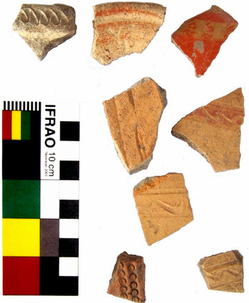
The excavation of the large, oval occupation mounds of Non Ban Jak and Non Muang Kao provide perspective on late to terminal Iron Age occupation in the UMRV.Footnote 29 Excavation of Non Muang Kao (first–sixth centuries CE), has revealed the remains of extensive housing structures, including plastered floors, post holes, graves lined with plaster, and clay floors with doorways and internal wall structures.Footnote 30 Limited burials were recovered, partially due to soil preservation issues. Burials recovered were interred with glass, agate, and metallic (bronze and iron) jewellery, as well as fine Phimai Black vessels, and an abundance of burnt rice. Non Ban Jak (fourth–eighth/ninth centuries CE), also displayed plastered clay floors, wooden sleeper beams, and wattle-and-daub walls, suggesting a housing complex or ‘town’, overlaying in one area an earlier Phimai Black kiln and an iron ploughshare.Footnote 31 The disturbed upper 50 cm–1 m of sediment at these sites includes evidence for fine, wheel-turned ‘Indic-style’ earthenware, most notably stylised wave, impressed circle, and red painted designs (fig. 4).Footnote 32 Indeed, the latest phase of occupation at Non Ban Jak extends, at least at some level, well into the Pre-Angkorian period (eighth, and potentially ninth century CE).Footnote 33 We argue that it is at these two sites, in particular, that we see the first clear evidence of a transition from prehistory into the earliest historical or Pre-Angkorian periods — that is, sites that experienced significant changes in the nature of settlement including ‘residential’ complexes, a ceramic tradition that combines both indigenously-developed and more external qualities, and the modification of encircling earthworks in support of developing an agricultural surplus.Footnote 34
Examples of Pre-Angkorian surface ceramics recovered near Non Ban Jak (photograph by Caitlin Evans, 1 Feb. 2014)

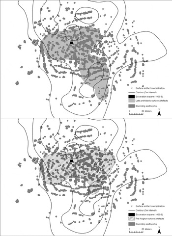
The excavation of Iron Age mounds shows varied and overlapping occupation between sites, weakening the argument for a sudden and widespread abandonment during the terminal Iron Age. As more prehistoric site types are excavated we see increasing evidence of intermittent or permanent use well into the Pre-Angkorian period. A series of excavations at Ban Non Wat, for example, have noted small but significant amounts of early historic ceramics in the upper half-metre of sediment. Indeed, many mounded sites in the area contain the remains of laterite and/or sandstone block structures in living memory, that have (sometimes very) recently been removed and, presumably, recycled. In other cases, as at Noen U-Loke, it seems that the centre of occupation has shifted a matter of metres between the Neolithic, Bronze, Iron Age, and post-Iron Age periods. This was not apparent during excavations at the site, but has been revealed from the high-resolution PSKAS surveys (fig. 5). Thus, abandonment of Iron Age sites in the fifth and sixth centuries CE may be more apparent than real.
Noen U-Loke mound with previous excavation square (black), encircling earthworks (dark grey), and Late Iron Age and Pre-Angkorian surface artefact concentrations recovered during PSKAS (light grey)

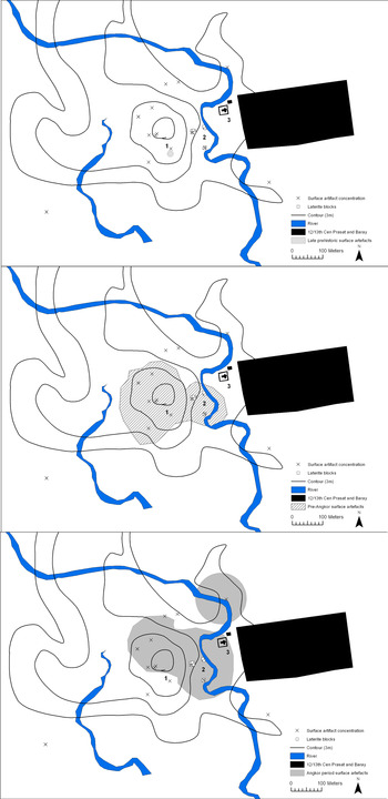
Is the reuse of sites restricted to the wet-rice powerhouses of the UMRV floodplains? Prasat Phon Songkhram is the only excavated multi-period site to be located in the terraces, beside a tributary of the Mun (fig. 1). It provides a perspective on occupation from a strategic position on the riverine trade route, connecting the UMRV to the Mun and ultimately the Mekong. In 2009 the FAD completed a small-scale excavation at Phon Songkhram, within the late twelfth to early thirteenth century laterite Arogayasala complex (hospital/ chapel) and pond complex, built during the reign of Jayavaraman VII (fig. 6).Footnote 35 The hospital is at the eastern edge of a 300 m diameter occupation mound, with the Phon Songkhram River diverted through the eastern third of the mound, between laterite-block embankments (likely a post-Angkor feature). As the excavation was intended to establish the base of the hospital complex as part of a FAD reconstruction project, test pits did not reveal any underlying earlier occupation strata. However, the PSKAS reconnaissance in 2012 did reveal evidence of a substantial early brick structure surrounded by large quantities of Pre-Angkorian ceramics, within the eastern half of the adjacent occupation mound. Several metres west of the brick scatter, closer to the peak of the occupation mound, human remains and prehistoric pottery were reportedly unearthed at an approximate depth of 3 m below ground surface by local residents during construction of a town well. Thus, while Phon Songkhram is best known as an Angkor period site, it is likely that it was a significant settlement during the prehistoric and Pre-Angkorian periods as well.
Phon Songkhram mound with 12/13th century CE structures (black), Phon Songkhram River (blue), and Late Iron Age, Pre-Angkorian, and Angkorian surface artefact concentrations recovered during PSKAS (light grey)

Interestingly, the centre of occupation material within the site separates incrementally over time; Late Iron Age occupation and burial evidence was concentrated on a large mound within the western half of the modern town boundary, whereas Pre-Angkorian period occupation shifted east, some 150 m, towards the banks of the modern Phon Songkhram River (fig. 6). Finally the Angkor-period hospital site was constructed a further 100 m east. We would argue that these micro-shifts appear typical of multi-period occupation sites in the UMRV and warrant further investigation. Furthermore, this site highlights the increasing separation between residential occupation and ceremonial spaces over time.
Excavations at the significant site of Muang Sema, some 65 km southwest of Phimai, also revealed a large, Pre-Angkorian ceremonial centre that developed from, and maintained a co-dependency with, a modest Late Iron Age settlement.Footnote 36 Originally a modest habitation mound containing cultural material dated to the fifth to sixth centuries CE, this phase of occupation is described as characteristically ‘late prehistoric’ by Khemica Wangsuk, or, alternatively typical of a ‘proto-Dvaravati’ period, as argued by Stephen Murphy (this vol.).Footnote 37 By the seventh to ninth centuries CE, a strongly Buddhist community appears to have emerged at Muang Sema. This is followed by a decidedly Angkor phase of occupation at Muang Sema (ninth to tenth centuries CE), when a second, much larger enclosing wall was built along with a central Angkor-period temple. Buddhist monuments and buildings were increasingly constructed outside the boundary of the complex, including a large reclining Buddha and a ‘wheel of law’ southwest of the wall. These construction episodes exemplify the gradual shift in nature of a settlement — away from something contained or easily defended by earthwork structures and towards a more sprawling urban centre with greater religious symbolism. Murphy describes this as a ‘cognitive change’ in the concept of a site — likely influenced by the introduction of ‘Dvaravati’ culture and Buddhist faith from central Thailand.Footnote 38 Murphy also points out that a large residential population would need to produce a surplus of rice to sustain a Buddhist monastery, such as at Muang Sema. In the UMRV, religious sites would be limited to locations near large wet-rice producing populations on the relatively fertile floodplains.Footnote 39 Here we see the likely limits on religious and sociopolitical development imposed by the UMRV's aridity.
At the Phimai complex we see the transition from Late Iron Age to the historic era as a consolidation. Prasat Hin Phimai is the central Angkor period sanctuary of a large moated settlement located along the banks of the Mun. The modern town of Phimai surrounds the site with the central sanctuary preserved as an historic park. The park area was restored and excavated during a series of projects from 1954 to 1971 led by UNESCO, FAD, Silpakorn University, and B.A.V. Peacock (table 1). An area within the central sanctuary of Prasat Hin Phimai was excavated in 1998.Footnote 40 The late prehistoric and historic sequences of Phimai indicate that it has remained a prominent site on the route between the Khorat Plateau and Chao Phraya Delta for at least the last 2,000 years.Footnote 41 Excavations uncovered a Pre-Angkorian brick structure that underlies the reconstructed eleventh-century CE Angkor-style central sanctuary. The earlier ‘square sump [un puisard carré]’-shaped temple made of finger-marked bricks is similar to an example found underlying an Angkor-period sanctuary at nearby Prasat Phanom Wan, and has been radiocarbon dated to the seventh to ninth centuries CE.Footnote 42 Ceramics from the layer contemporary with the construction of the brick temple are cord-marked or incised fine earthenware, including carinated pots. These ceramics are immediately followed by the wheel-formed, thin, well-fired, orange or pink earthenware, often with an incised shoulder, typical of the pan-regional, standardised ‘Dvaravati’ tradition of the sixth centuries CE.Footnote 43 Phimai Black and red-slipped cord-marked ceramics were recovered from layers underlying the temple, and appeared to be Iron Age (fifth century BCE–third century CE).Footnote 44 This observation was supported by earlier excavations at the adjacent site of Ban Suai, where a significant Iron Age occupation mound was revealed, including over 400 sherds of Phimai Black ceramics. The Ban Suai mound lies within the Angkorian period town boundary identified by a significant laterite wall and surrounding moat.Footnote 45 Thus, the evidence from Phimai suggests a single site or group of significant occupation sites established in the Late Bronze or Early Iron Age, and associated with the strong regional ceramic tradition (Phimai Black). Prasat Hin Phimai potentially acted as a point of consolidation for these neighbouring late prehistoric villages, including Ban Suai. By the Pre-Angkorian period Phimai had developed into a (relatively modest) regional centre, but was redeveloped extensively (reusing some pre-existing materials) during the reign of Jayavarman VI (late eleventh to early twelfth century CE) and later by Jayavarman VII (late twelfth to early thirteenth century CE), into the significant Angkor temple complex evident today.
In his discussion on KBAP, Welch stresses that the transition to the ‘Muang Sema’ period in the UMRV is dominated by the continuation of large ‘moated’ sites at the centre of Iron Age communities. This site reuse, he argues, continued well into historic times. The sites surveyed throughout PSKAS largely support this contention. Indeed, the project revealed that half of all Late Iron Age sites were occupied into the later period. Large, Late Iron Age centres in the floodplains, which successfully transitioned, tended to maintain a staple crop production focus, with intense wet-rice agriculture, animal husbandry, iron and stone tool production, and carnelian beads. Such specialisation in the (selective) reuse of these sites is further reflected by the presence of hoes and sickles, and ploughshares, along with abundant rice found in mortuary contexts at Noen U-Loke, Non Muang Kao and Non Ban Jak.Footnote 46 Multi-period sites of historical significance, such as Phimai and Muang Sema, often grew from modest Late Iron Age settlement(s), acting as a point of consolidation for the community.
There is evidence for the gradual modification of site features, most notably moat adaptation (circular–oval–rectangular), perhaps to facilitate the irrigation of field networks (Higham; O'Reilly and Shewan, this vol.). Furthermore, the cultural assemblage, interment ritual, evidence of housing, and centre of occupation all show signs of physical and cultural ‘shifts’ or development over time. Certainly by the mid-to-late Pre-Angkorian period, cultural traditions within the UMRV, despite continuing within the bounds of many large Late Iron Age centres, have changed markedly.
A Pre-Angkorian era
Following the terminal Iron Age, but prior to the spread of artefacts associated with Angkor (green and brown glazed stoneware, pale green gres, greenish-white Qingbai ware, etc.) in the mid-ninth and early tenth centuries CE, is a period when distinctive ‘Indianised’ or ‘Dvaravati’ style artefacts (sema stones, finger-marked bricks, carinated vessels, kendi, etc.) become well-established in the UMRV. This period, which we term ‘Pre-Angkorian’ here, dates to the seventh to early ninth centuries CE and encompasses an early body of texts and Khmer and Sanskrit inscriptions. Evidence for the Pre-Angkorian period in the UMRV includes limited excavation, survey, and a large body of art historical research. Together with the PSKAS results, these sources describe two major settlement trends: the construction of religious/sociopolitical/administrative features, and associated epigraphy, aligned with tributaries of the Mun, and the spread and division of lay communities across all landscapes of the UMRV.
Archaeological evidence regarding site density in the UMRV during the mid-sixth to ninth centuries CE is somewhat conflicting. KBAP describes a rise in the number of ‘Muang Sema’ (sixth–tenth century CE) sites in the ‘uplands’ (upper terraces), but a reduction in floodplain sites. This suggests an overall stable site density by the sixth century CE, and by inference, a stable population size. The KBAP results, however, only consider sites visible to aerial photography. In the floodplains and low terraces, PSKAS has revealed many small mounds and flat surface artefact scatters, not visible in aerial photographs, which contained Pre-Angkorian style artefacts. When these small, usually single-period sites were included in settlement patterns, PSKAS found that the total number of sites rose markedly during the Pre-Angkorian period; from 15 Late Iron Age sites, to 27 Pre-Angkorian sites.
Where KBAP and PSKAS are in accord is that Pre-Angkorian period sites tended to be smaller and less densely occupied then their Late Iron Age counterparts. PSKAS recorded a 31.19 per cent reduction in average site size and a marked drop in the average density of artefacts within a site, and KBAP also noted a reduction in ‘Muang Sema’ period site sizes by approximately a third. A rise in site numbers, thus, is more likely to reflect the structural reorganisation of sites and the introduction of small, isolated ‘hamlets’, rather than a boom in population or a sudden influx of people. KBAP suggests this reduction in the average site size may be associated with the appearance of small satellite settlements.Footnote 47 Seasonal or temporary accommodation, useful during planting seasons, or (small-scale) production sites (for salt, laterite, clay), must also be considered here.
There is a notable colonisation of the upland hill slopes during the Pre-Angkorian period. PSKAS recorded four sites in the uplands, located along the relatively fertile corridor (likely the remains of a fossil channel), linking a tributary of the Chi system (Luek River), to a tributary of the Mun system (Khamin River). KBAP also argues for a broad shift of population centres towards upland areas locally and inter-regionally to the north of modern Thailand.Footnote 48 The KBAP team suggests that this spread into higher elevations, and proliferation of small sites in terraced zones, may relate to salt production.Footnote 49 However, initial results from the PSKAS distance-analysis, between all known Pre-Angkorian sites and saline soil, does not support a significant relationship (table 3). In fact, the very pervasiveness of salt and potentially lateritic deposits, across much of the UMRV, coupled with increasing evidence for household production well into late prehistory, would have made monopolisation of this resource challenging.Footnote 50 Furthermore, when new settlements in higher elevations are examined in detail, it is clear that although they are located in challenging and agriculturally unviable areas, they can also be interpreted as upriver extensions from pre-existing Late Iron Age communities. It would appear that lay communities cautiously extended into new, challenging areas by following the remnants of fossil channels emerging from the floodplains. This further reinforces the strong relationship between water features, past and present, and these early historic settlement patterns.
Distance of Pre-Angkorian sites from saline soil and salt outcrops

This spread into new landscapes and division of sites is not sufficiently systematic — in site size or spacing — to suggest reorganisation into a single, unified, settlement system.Footnote 51 PSKAS noted that the rank-size of Pre-Angkorian period sites in the UMRV is somewhat convex, similar in shape to Late Iron Age site-size ranking, but with a greater proportion of mid-sized sites and a less pronounced drop-off as we approach the smallest site sizes. This indicates a slight increase in regional integration through time, but not the full integration one might expect from a single, unified polity.Footnote 52
When archaeological evidence of the Pre-Angkorian period is considered overall, two major trends emerge. There were changes in lay communities during the mid-sixth to ninth centuries CE: site size reduced by a third, the number of sites increased markedly and spread into small–medium villages in the heavily forested uplands, and site types become more varied. While the upper elevations are heavily reorganised, it appears there is still occupation of alluvial floodplain sites. Modest-sized centres develop within or near these sites — the material assemblage from reused sites suggests these are production and staple crop-focused. Such production was, perhaps, necessary to support dependent monastic communities and a growing population living in less agriculturally viable regions (i.e. upland areas). Occupation at many of the centres, however, is likely to be seasonal or intermittent, certainly by the eighth and ninth centuries CE.
In contrast, religious/sociopolitical/administrative features (monuments, temples, and sema stones) were constructed in a regularly-spaced, linear pattern along the banks of perennial tributaries, connecting the northwest UMRV to the Mun River itself, and ultimately the Mekong. Potentially, the PSKAS or KBAP survey areas may not encompass key large or intermediary residential centres associated with these features. Alternatively the large floodplain sites and small to medium-sized new villages might be a true representation of ‘residential’ occupation or lay communities, whilst the significantly larger complexes (Muang Sema, Phimai) and associated monuments and inscriptions were constructed and placed to meet particular religious, political and/or administrative needs. The nature and timing of these continuously occupied sites needs to be examined in further detail, and in comparison with wider trends in mainland Southeast Asia.
Regional comparisons
This section discusses the archaeological and art historic findings from or about the UMRV in the context of mainland Southeast Asia, specifically the role of neighbouring central Thailand and a northwest Cambodian/ Mekong Delta-based polity or polities. Whilst the art historical evidence emphasises the relationships and commonalities between the UMRV and these polities, the archaeological and settlement data indicate that the UMRV had a relatively delayed or limited developmental sequence from prehistory to history, with little evidence of integration into a neighbouring polity, or development of a unified polity in its own right. This, we argue, stems from the relative aridity and unpredictability of the UMRV landscape.
Contemporary with Pre-Angkorian UMRV, and leading into the Angkor period proper, is the spread of sites across central (and perhaps northeast Thailand), which are defined by coincidences of architecture, statuary, and ceramics, attributed to ‘Dvaravati’ culture.Footnote 53 Described by contemporary Chinese travellers as the ‘To-lo-po-ti’ state and later translated as Dvaravati by the Ayutthaya chronicles (‘… krung thep dvaravati sri ayutthaya …’), the Dvaravati are thought to be an ethnically Mon polity (or group of related polities) based in the Chao Phraya Basin during the fifth to the eleventh centuries CE.Footnote 54 Unlike Funan and the later Zhenla (Chenla) to the southeast and east of the UMRV, Dvaravati predominantly utilises Buddhist, and to a lesser extent Brahmanical, iconography.Footnote 55 Iconographic evidence in monuments, temples and isolated statues found in the UMRV has led many to describe its western half as the Dvaravati ‘hinterland’.Footnote 56 Phimai and Muang Sema are two well-known examples of sites located in northeast Thailand that contain evidence of Pre-Angkorian temples and monuments in the Dvaravati-Mon style. In northeast Thailand features of this style include brick or laterite wat (monastery or temple) that usually consists of a viharn (assembly hall), ubosoth (ordination hall), and a stupa or chedi (stepped hemispherical mounds).Footnote 57 Discoveries of Buddhist bronzes indicate an early relationship between southern India, via central Thailand, and the UMRV. There is a concern, however, voiced over the original provenance of these statues, as they are often isolated finds with high portability.Footnote 58 However, in 1964 the Prakhon Chai hoard was discovered within a small seventh-century brick temple, in Khao Plai Bat, Buriram province (fig. 1).Footnote 59 The hoard likely contained over 300 statues dating as far back as the sixth century CE. The design of these statues varied greatly, incorporating a combination of Dvaravati and Mekong Basin styles, mixed with local traits. This regional, and inter-regional, variability in religious iconography was highlighted by Srisakra Vallibhotama following his 1982 settlement pattern survey.Footnote 60 Vallibhotama noted that Buddhist wheels, figures of Buddha, and other Buddhist iconography were more prevalent in the west, while iconography associated with Hinduism, in particular, Vishnu and Shiva, were more prevalent in the east. The site of Sri Thep in the Pasak Valley, 175 km west of Phimai, depicts ‘numerous [types of] Hindu gods, both large and small’.Footnote 61 This variation led Vallibhotama to argue for multiple Dvaravati regions in Thailand. One such regional power, described as Sri Canasa, was potentially based at Muang Sema, or nearby Sri Thep.Footnote 62 Sri Canasa is mentioned on a stela (K.400) of the tenth-century temple of Bo Ika near Muang Sema, with an inscription dated to 868 CE commemorating the gift of a gold linga and slaves by Ansadeva, who obtained them from an abandoned domain ‘outside Kambudesa [Cambodia]’.Footnote 63 On the other side of the stela is a second inscription, dated to the seventh century, which describes gifts of labourers and buffaloes to a Buddhist monastic compound by the leader of Sri Canasa.Footnote 64 Sri Canasa is the only Pre-Angkorian polity in northeast Thailand for which we have evidence.Footnote 65 However whether Sri Canasa existed at all, and whether it was independent or a component of a larger neighbouring power, remains a source of debate.
Scattered inscriptional evidence, primarily on sema stones, supports the presence of independent local chiefs or rulers from the late sixth/early seventh century onwards in the UMRV.Footnote 66 Of particular note is an eighth-century inscription (K.1000), located at Prasat Hin Phimai, describing a new, local king called Sauryavarman, with Buddhist affiliations. Additionally, the Hin Khon (stone marker) inscriptions (K.388 and K.389) near Muang Sema are written with a mix of Khmer and Mon scripts, paired with a Sanskrit version, to describe how a Buddhist monk, identified as King Nrpendrahiphativarman, erected a Buddhist monastery and temple, to which he donated ten pairs of cattle, gold and silver utensils, rice fields, and betelnuts. This inscription also references two other local leaders, including another Buddhist king — Sauryavarman, possibly the same person noted above and who ruled in the Phimai region during the eighth century CE.Footnote 67 These inscriptions indicate a continued succession of local leaders with Sanskrit names, paying homage to Buddhist deities and ruling over a populace that primarily spoke local Mon-Khmer dialects.Footnote 68
Archaeological evidence presented by Higham and Rispoli strongly supports the integration, or at least regular trade, between central Thailand and the UMRV, via a pass in the Phetchabun Range.Footnote 69 They argue that similarities in exotic gold, glass, carnelian, and agate ornaments from mortuary contexts indicate elite exchange between the UMRV and Lopburi province in central Thailand, during the Late Iron Age. This relationship also encompassed an export–import relationship with regards to the mining and consumption of copper-based artefacts, and the spread of ideas relating to iron-smelting technology, large-scale construction of encircling moats, and housing infrastructure. The question is whether this trade remained a mutually beneficial relationship between two distant, independent neighbours, or was there an organisational or sociopolitical integration of these two regions.
A comparison of settlement organisation and ranking, on the other hand, highlights the disparity in settlement patterns between central Thailand and the UMRV. The Kok Samrong-Takhli Undulating Terrain (KSTUT) systematic pedestrian survey of the Upper Chao Phraya River Valley (UCPRV) in central Thailand noted that occupation spread into a variety of landscapes during the metal ages, with average site size increasing markedly in the upland areas during the Bronze Age.Footnote 70 Depopulation of the central Thai uplands began in the Iron Age (first–fourth centuries CE), and was completed by the mid-sixth century. This coincided with an increase in alluvial floodplain sites, a third of which were continuously occupied from the first century onwards. These reused sites, Eyre notes, are primarily on soils well suited to wet-rice agriculture (Lopburi low phase and Ban Mi). Overall, occupation evidence declined during the Pre-Angkorian period in the UCPRV. PSKAS noted an almost exactly contrary pattern in terms of landscape use, with a spread into higher elevations and a slight increase in occupation levels during the mid-sixth to ninth centuries CE. However, the reuse of Iron Age sites located on floodplain soils, well-suited to wet-rice, is common between the two project areas. This may (partially) relate to the need for a large rice surplus to support a growing Buddhist monastic community in both central Thailand and the UMRV.
Rank-size analysis in the KSTUT survey metal age (including Late Iron Age) sites have returned very similar results to those from PSKAS, with a strongly convex shape to the graphic representation of the data (fig. 3). KSTUT's post-Iron Age or ‘Dvaravati’ results are dominated by the large town of Chansen. In comparison, the PSKAS results for the mid-sixth to ninth century CE remain poorly integrated, even when large nearby towns, such as Muang Sema, are adjusted for. It is likely that the large Late Iron Age mounds of the UMRV, such as Non Ban Jak and Non Muang Kao, continue to grow entering into the Pre-Angkorian period, and create multiple competing centres. Muang Sema has been identified potentially acting as a second-tier settlement in the Dvaravati ‘hinterland’.Footnote 71 If the UMRV was the hinterland of a large and established supra-regional settlement, one might expect similarities in site-size ranking between the UMRV and UCPRV. However, the UMRV could not be said to mirror the ranked pattern of settlement integration developing in the UCPRV.
Beyond a focus on wet-rice agriculture, there appear to be few connections in land use between the UMRV and central Thailand. The other point to consider is the low number of Buddhist boundary markers or sema stones (seventh–twelfth centuries CE) in the Mun River, and their (relatively) isolated placement. Murphy suggests this indicates less of a Dvaravati influence and a ‘much stronger Chenla and later Khmer influence in the region, which could have made its way here by following the Mekong River, originating from the area around Sambor Prei Kuk in present day Cambodia’.Footnote 72
Thus we turn to the southeast. There is strong historical evidence for communication and perhaps trade, between northeast Thailand and late prehistoric communities located northwest of the Tonlé Sap Basin, below the Dang Raek Mountains.Footnote 73 Several early inscriptions recovered from the UMRV describe invasions by southern Cambodian leaders along Mekong tributaries, principally the Mun River. This includes a late-sixth-century CE Sanskrit inscription at Tham Pet Thong cave, near the present Thai–Cambodian border, by Sitrasena (Citrasena), the brother of Bhavavarman I.Footnote 74 Inscriptions attributed to Sitrasena are also found at Wat Sri Mueang Aem in Khon Kaen and include the Pak Nam Mun Inscription One, the Pak Nam Mun Inscription Two, the Wat Supattanaram Inscription One and the Tham Phu Manai Inscription in Ubon Ratchathani.Footnote 75 Another such inscription, this time located at Phimai (K.1106) describes a military victory beyond the Dang Raek Mountains (presumably originating from the south). This has led researchers to suggest Chenla leaders Mahendravarman (550–611 CE) and later his son Isanavarman, invaded towns along the Mun River, appointing relatives to rule over the conquered territory.Footnote 76 However, a lack of subsequent inscriptions suggests the early invasion and control of Mun River settlements was a brief event, without any long-term consolidation of governance over the area.Footnote 77 Vickery notes that the tenor of Isanavarman's inscriptions does not reflect direct rule or control from south of the Dang Raek range, rather,
[l]ocal elites merely evoked his suzerainty while maintaining their own local authority … Outside his core kingdom in Kompong Thom the records suggest rather autonomous local chiefs sometimes voluntarily acknowledging some kind of super-ordinate hierarchy, but not subject to direct rule by the suzerain.Footnote 78
Archaeological evidence of a relationship between northwest Cambodia and the UMRV is growing, as more ‘pre-state’ sites (first–eighth centuries CE) in northwest Cambodia are recovered. The recently published Late Iron Age site of Phum Lovea highlights antecedent qualities that preceded the development of the Angkorian state in full, in the early ninth century CE; these qualities included ‘increasing sociopolitical complexity, intensified inter- and trans-regional mercantile activity, differential access to resources, social conflict, technological transfer, and developments in site morphology’ (O'Reilly and Shewan, this vol.). Higham (this vol.) presents evidence that similar qualities in Late Iron Age settlement are present in the UMRV, most notably: the development of a sophisticated canal structure from encircling earthworks to encourage a rice surplus, the presence of ‘elite’ families, the industrial exploitation of iron and salt, and commonalities in interment ritual and ceramic styles. Phimai Black ceramics, for example, which originated in the UMRV, have been found as far southeast as Prei Khmeng, Phum Snay, Phum Sophy and Kok Treas in northwest Cambodia.Footnote 79 Similarities in the organisation of agricultural field systems further emphasise a relationship between northwest Cambodia and northeast Thailand. Scott Hawken has revealed a localised and irregular ‘radial’ field structure in the Tonlé Sap region.Footnote 80 Although undated, these structures display similar qualities to those constructed in Late Iron Age northeast Thailand, in support of a decentralised and highly localised Iron Age community. These archaeological parallels support a strong relationship, and perhaps even a tandem cultural development, having occurred either side of the Dang Raek Mountains.
Further southeast, within the Mekong Delta itself, an ‘overgrown tribal confederacy’ was emerging during the first half of the first millennium CE.Footnote 81 There are indications that this confederacy consisted of several competing polities, with Chinese documentary sources describing the ‘kingdom’ of Funan (first–sixth centuries CE) located in the Delta and encompassing the major trading port of Oc Eo.Footnote 82 Did related settlement and cultural traditions stretch as far southeast as the heart of the Delta?
Similarities in the transition through ceramic assemblages can be used as evidence of a common sociopolitical and/or economic trajectory over time, or as direct evidence of trade or partnership. When comparing the Mekong Delta to the UMRV several parallels in ceramic sequences are apparent. Early cord-marked, paddle-and-anvil earthenware vessels, recovered from Angkor Borei (fifth century BCE–second century CE) have obvious parallels with the cord-marked earthenware vessels typical of the Bronze and Iron Ages in the UMRV (fifteenth century BCE– fifth century CE).Footnote 83 Furthermore, the succeeding ‘fine orangeware’ (first century BCE–third century CE) and ‘fine buffware’ (third century CE onwards), or ‘Type V’ ceramics, recovered from various settlements of the Mekong Delta, display striking similarities in form, fabric, and finish with the ‘Indic-style’ thin, buff, wheel-turned earthenware vessels recovered in Pre-Angkorian UMRV sites (mid-sixth to ninth centuries CE).Footnote 84 However, the ceramic sequence appears to have occurred some three centuries earlier in the Mekong region. Evidence for a somewhat delayed transmission and trade of material culture between the Mekong Delta and northeastern Thailand is supported by Alison Carter's 2013 study of Iron Age trade and the manufacturing of stone and glass beads across Cambodia and Thailand.Footnote 85 Carter's study noted that the trade of beads between the Mekong Delta and northeast Thailand regions occurred following an expansion of inland trade networks in the mid-first-millennium CE.
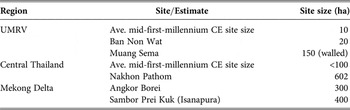
Comparisons in settlement patterns between the UMRV and the Mekong Delta are less convincing, however. The site, and by inference sociopolitical, organisation in mid-first-millennium CE Mekong Delta, is developing tiers, well above that recorded in the UMRV — with the largest recorded sites several times larger than those recovered from the UMRV (table 4). This discrepancy may be partly explained when we note that Mekong Delta settlement size estimates are (primarily) based on a walled structure enclosing the settlement, rather than the spread of surface artefacts. Both Matthew Gallon and Karen Mudar have demonstrated that walled enclosures (in central Thailand ‘Dvaravati’ complexes) do not accurately represent residential settlement. Large areas of open, unoccupied land within walled settlements can substantially exaggerate site size and population estimates. Within Kamphaeng Saen of central Thailand, for example, only 68 per cent (or 35.7 ha) of the enclosed area contained evidence of occupation.Footnote 86 When large, walled centres in the Mekong Delta are reduced in size by approximately a third, results become more comparable with the UMRV, but are still (on average) far larger than their northeast Thailand counterparts.Footnote 87 There remains little evidence of the upper levels of site hierarchy in the UMRV, which characterise neighbouring polities of the Mekong Delta.
Comparison of site sizes in the UMRV, central Thailand and the Mekong Delta

Comparisons between the UMRV and neighbouring polities to the west (Dvaravati) and to the southeast (northwest Cambodia/ Mekong Delta) that emerged in the first half of the first millennium CE, demonstrate that the UMRV was at the crossroads of several inland exchange and communication routes, bringing an influx of architectural styles and technologies, trade items, and cultural practices. Furthermore, art historical and epigraphic evidence does support the expression (at least locally) of religious and sociopolitical practices. This display of epigraphic, architectural, inscriptional, and stylistic features characteristic of the Dvaravati, Chenla/ Funan, and later ‘Angkor’ language in the UMRV, has led many to perceive the existence of pan-regional unified states or kingdoms in mainland Southeast Asia, including (peripherally) the UMRV. Indeed, there is currently a push in the literature to describe the development in the UMRV in terms of much earlier relationships to neighbouring polities to the west and southeast — and by inference suggest that the seeds of religious and sociopolitical development in this region are present by the Iron Age. However, consideration must be given to the purpose and source of documentary evidence, when interpreting it.Footnote 88 Colin Renfrew points out that common art or styles do not necessarily imply the direct influence of a unified state.Footnote 89 The visibility and permanence of monuments and structures from, or related to, foreign ‘Indianised’, Chinese, and Mekong Basin sources, in comparison with the regional or local products, favours an interpretation of this period as sudden and introduced, rather than gradually and indigenously developed.Footnote 90 Common artistic and architectural traditions could also be a product of multiple interactions between peer polities.Footnote 91 Religious and/or sociopolitical features along the riverine route may have acted as a display of territorial boundaries and ownership by powerful individuals, or a measure of spiritual protection for new visitors.Footnote 92 Or they may have served their purpose during construction: the very act of building these temples, monuments, and enclosing walls and moats would have facilitated a break away from the kinship-based communities of prehistory towards a more complex and cohesive form of community.Footnote 93
Archaeologically, the evidence for integration, or development of an organisational structure to rival the major polities of mainland Southeast Asia, is much weaker. There are common features of settlement: the reuse and development of wet-rice agriculture in alluvial floodplain sites, participation in the growing maritime trade network, and the construction of ‘Indic-style’ Buddhist temples, monasteries, and sema stones in the sixth to eighth centuries CE. Furthermore, there appears to be a particularly strong relationship, in terms of cultural tradition and site morphology, with Late Iron Age communities of northwestern Cambodia, and links in ceramic-style with Angkor Borei and the Mekong Delta. However, these can (predominantly) be explained in terms of the transmission of ideas and goods through trade networks. When we examine overall settlement patterns in the UMRV, there is little evidence for an integrated or multi-tier settlement system, such as we already see developing in central Thailand and the Mekong Delta, until much later in the chronological sequence, if at all. Up till, and perhaps including, the ninth century CE, settlement appears to have been a relatively modest and divided affair in the UMRV. If a UMRV polity (or polities) existed, it was certainly not large or cohesive enough to rival contemporary ones in the Mekong Delta or central Thailand.
Conclusion
Evidence presented here, from excavation and survey, historical sources, and PSKAS, has confirmed the complex and unique transition from Late Iron Age to the early historical era in the UMRV. The Late Iron Age was a period of growth and consolidation, with large, alluvial floodplain centres expanding, the construction of encircling earthworks in multiple phases, the display of wealth in the mortuary record, trade items, and the introduction of standardised ceramic styles. There was, however, little evidence of reorganisation of settlement patterns, to support a multi-tier hierarchical organisation or religious/sociopolitical associations with external parties, at this early stage.
Immediately after the Late Iron Age, there appears to have been a gradual transition within large burial and occupation mounds of the UMRV. Systematic surface artefact collection by PSKAS has revealed early historic material in the upper layers of a number of key UMRV sites, including Noen U-Loke, Non Ban Jak, and Phon Songkhram. The sudden ‘abandonment’ of Late Iron Age sites leading into the early historic period appears unlikely, or at least to have occurred at a much later period (i.e. ninth century CE). However the archaeological expression of cultural traditions, interment ritual, housing, and irrigation, were all heavily adapted during this transitional period. This supports Murphy's argument (this vol.) for a new transitional or ‘proto-Dvaravati’ period in the fourth to fifth (and we would argue early sixth) centuries CE at large Iron Age sites. By the time characteristically ‘Indianised’ ceramic assemblage entirely infiltrates the UMRV (seventh, eighth, and ninth centuries CE), we would argue, settlement patterns change markedly and occupation at these transitional or ‘proto-Dvaravati’ sites, may have been more of an intermittent, seasonal, or production-focused nature.
By this later period there is evidence for a rise in site numbers, a diversity of site types, and a spread of small-to-medium habitation sites into terraced and dry uplands of the UMRV; furthermore, monuments, temples, and inscriptions enter the archaeological record. These results highlight the drawn-out and rather restricted nature of the transition from prehistory to history in the UMRV.
The separation in settlement patterns by the seventh, eighth, and ninth centuries CE also point to a cultural division or physical split in the community. Monuments, temples, sema stones, and other religious architecture, often in enduring brick or laterite, could be viewed as a display of power for visitors by local leaders struggling for control, or perhaps placating religious specialists/devotees who frequented the site (Revire, this vol.), whilst lay communities continued to maintain their long-term settlement and structure, with a local village or kinship focus, well into the historic periods, with expansion into nearby upper terraces and uplands. Indeed, the cautious spread of lay communities into the previously unoccupied ‘uplands’ of the UMRV may relate to a need to move away from increasing displays of power, and potentially landownership, of Mun River-based leaders. Certainly the UMRV appears to have retained a degree of separation between lay communities and sociopolitical or religious machinations. This, perhaps, developed into a somewhat hybrid or cooperative approach to sociopolitical organisation, by the time the Angkorian state declares northeast Thailand a frontier or hinterland.
Researchers have argued for earlier and more emergent evidence of cultural development (Murphy, this vol.) and a wider network of pan-regional communication and trade in the UMRV (Higham, this vol.), than previously thought. However, this article has confirmed the unique, localised, and somewhat delayed transition from late prehistory to history in UMRV, which resists full integration under an external power, or development into a competitive polity in its own right. Given its strategic positioning, facilitating early communication and trade with neighbouring polities, this seems surprising. The cause may lie in the land-locked, arid, and water-scarce landscape of the UMRV. Such a challenging landscape is more likely to foster multiple, strong kinship links, rather than an overarching organisation. From a complexity approach: the stronger and more multitudinous the small-scale connections, the more resilient a population are to environmental and social fluctuations, which might cause a collapse.Footnote 94 This, however, also renders a population less likely to undertake sudden religious and/or sociopolitical change.Footnote 95 Complexity encourages the gradual, indigenous adaptation of emerging ideas, and may explain the delayed or restricted sociopolitical development within the UMRV.
A full examination of this idea will require an expanded research effort, with comparative high-resolution pedestrian surveys in a variety of mainland Southeast landscapes. Our main problem in proceeding with this sort of research is perhaps a good one to have: it is simply that the scale of the work is great. To date, over four decades of survey and excavation have been carried out in the general PSKAS area, and yet we are more aware than ever that we are just scratching the surface.