INTRODUCTION
Lakes can be viewed as connections and points of interaction between subsystems of Earth and thus serve as important archives for global environmental changes (Goldsmith et al., Reference Goldsmith, Broecker, Xu, Polissar, Demenocal, Porat, Lan, Cheng, Zhou and An2017; Tierney et al., Reference Tierney, Poulsen, Montanez, Bhattacharya, Feng, Ford and Honisch2020). Paleoenvironmental changes at different timescales can be reconstructed based on proxy records from lake sediments and landforms (Zhang et al., Reference Zhang, Peng, Ma, Chen, Feng, Li, Fan, Chang, Lei and Wünnemann2004; Melnick et al., Reference Melnick, Garcin, Quinteros, Strecker, Olago and Tiercelin2012; Wang et al., Reference Wang, Liu, Zhao, Yin, Zhu and Snowball2012, Reference Wang, Cheng, Luo, Zhang, Deng, Yang and Liu2019). However, the relationship between lake evolution and the hydrological cycle in arid and semiarid regions is complex (Yang and Scuderi, Reference Yang and Scuderi2010; Garcin et al., Reference Garcin, Melnick, Strecker, Olago and Tiercelin2012; Shen, Reference Shen2013; Wang et al., Reference Wang, Ning, Li, Wang, Jia and Ma2016). Such changes are influenced by both climatic factors, including precipitation and evaporation (Yang et al., Reference Yang, Ma, Dong, Zhu, Xu, Ma and Liu2010; Jin et al., Reference Jin, Li, Li, Duan, Wen, Wei, Yang, Fan and Chen2015), and non-climatic factors, such as neotectonics (Wang and Ji, Reference Wang and Ji1995), river diversion (Jin et al., Reference Jin, Li, Li, Duan, Wen, Wei, Yang, Fan and Chen2015), and glacial meltwater input (Fan et al., Reference Fan, Xiao, Wen, Zhang, Huang, Yue and Wang2019). In some areas, non-climatic impact factors play a more important role in lake evolution than climatic factors (Hartmann and Wünnemann, Reference Hartmann and Wünnemann2009; Yang and Scuderi, Reference Yang and Scuderi2010). Therefore, determining the driving factors for lake evolution in arid and semiarid regions is essential for the accurate assessment of paleoenvironmental changes. Moreover, this will further current understanding regarding regional environmental changes as a response to global climate change.
The Badain Jaran Desert, located in the arid region of northwestern (NW) China, lies in the climatic transition zone between the Asian summer monsoon and the westerly belt. This region is sensitive to climate change and is of great significance for discussing the interaction between the Asian summer monsoon and westerly circulation systems and its impact on the regional climate (Yang et al., Reference Yang, Liu and Xiao2003, Reference Yang, Ma, Dong, Zhu, Xu, Ma and Liu2010; Li et al., Reference Li, Wang, Li, Ning, Cheng and Zhao2015b, 2018; Wang et al., Reference Wang, Ning, Li, Wang, Jia and Ma2016; Chen et al., Reference Chen, Lai, Liu, Wang, Wang, Miao, An, Yu and Han2019). A total of 110 closed inland lakes lie between megadunes in the southeastern desert (Wang et al., Reference Wang, Ning, Li, Wang, Jia and Ma2016). In previous studies, researchers have reconstructed lake evolution and discussed effective moisture changes based on these lake shorelines (Wang et al., Reference Wang, Ning, Li, Wang, Jia and Ma2016) and sediments (Chen et al., Reference Chen, Lai, Liu, Wang, Wang, Miao, An, Yu and Han2019; Ning et al., Reference Ning, Wang, Lv, Li, Sun, An and Zhang2019). However, lakes in the desert hinterland are mainly recharged by groundwater and not by river runoff (Dong et al., Reference Dong, Wang, Chen, Li, Chen, Chen and Ma2016; Wang et al., Reference Wang, Ning, Li, Wang, Jia and Ma2016). Therefore, it is unclear whether these local lake-level fluctuations in the desert hinterland were sensitive to the climate change between arid and humid environments during the Holocene. Therefore, reconstructing millennial-scale precipitation and effective moisture changes is useful for addressing these questions.
Calcareous root tubes (CRTs), also called rhizoliths, are pedogenic carbonate encrustations produced by roots and microorganisms in calcareous soils or in eolian deposits in the rhizosphere of terricolous plants (Klappa, Reference Klappa1980; Li et al., Reference Li, Wang, Li, Ning, Cheng and Zhao2015b; Zamanian et al., Reference Zamanian, Pustovoytov and Kuzyakov2016). CRTs are widely distributed in the desert (Li et al., Reference Li, Wang, Cheng, Ning, Zhao and Li2015a). Yang (Reference Yang2000) first used radiocarbon methods to date the CRTs and discussed the landscape evolution and precipitation changes in the desert. In contrast to lakes in the desert hinterland, which are affected by groundwater flows, the formation of CRTs is mainly controlled by changes in soil moisture, which is affected by precipitation and evaporation but not by groundwater (Li et al., Reference Li, Wang, Cheng, Ning, Zhao and Li2015a, Reference Li, Wang, Li, Ning, Cheng and Zhao2015b; Gao et al., Reference Gao, Li, Wang and Li2019; Zhu et al., Reference Zhu, Li, Gao, Chen and Yu2019). Moreover, 14C carbonate dating for Holocene CRTs is reliable at the millennial scale (Kuzyakov et al., Reference Kuzyakov, Shevtzova and Pustovoytov2006; Pustovoytov et al., Reference Pustovoytov, Schmidt and Parzinger2007; Gocke et al., Reference Gocke, Pustovoytov, Kühn, Wiesenberg, Löscher and Kuzyakov2011; Li et al., Reference Li, Zhu, Gao, Chim and Liao2020b). As a result, CRTs have been considered a suitable material for reconstructing paleoenvironmental changes in the deserts of NW China (Li et al., Reference Li, Zhu, Gao, Chim and Liao2020b). They have been used in numerous paleoenvironmental reconstructions of effective moisture, precipitation, and paleovegetation (Li et al., Reference Li, Gao and Han2017; Gao et al., Reference Gao, Li, Wang and Li2019, Reference Gao, Li, Zhu and Wang2020b). Among these, Mg/Ca ratio is viewed as a proxy of effective moisture (Gao et al., Reference Gao, Li, Wang and Li2019), and phytolith assemblages can be used to reconstruct mean annual precipitation (MAP) quantitatively at the millennial scale during the Holocene (Gao et al., Reference Gao, Li, Zhu and Wang2020b). However, such methods have not previously been applied in the Badain Jaran Desert to reconstruct such changes.
In this study, 10 Holocene CRT samples were collected from the southeastern region of the Badain Jaran Desert, and effective moisture and precipitation changes during the Holocene were reconstructed from the CRTs. We then compared the results with the evolution of the groundwater-recharged lake to clarify whether the lake-level fluctuations are sensitive to climate change between arid and humid environments.
STUDY AREA
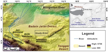
The Badain Jaran Desert (39°04′–42°12′N, 99°23′–104°34′E) is located in the western part of the Alashan Plateau of NW China (Fig. 1), covering an area of 52,100 km2 with an elevation of 900–1500 m (Zhu et al., Reference Zhu, Wang, Chen, Dong and Zhang2010). It is characterized by a strong continental climate (Xu and Li, Reference Xu and Li2016; Li et al., Reference Li, Wei, Zhou and Tian2020a). In this desert area, the mean annual temperature ranges from 8.8°C to 9°C (Li et al., Reference Li, He and Chen2018). Precipitation occurs predominantly in summer (from June to August), and the annual average precipitation is approximately 35–115 mm, which decreases markedly from southeast to northwest across the region (Ma et al., Reference Ma, Wang, Zhu, Chen, Chen and Dong2011). The annual evaporation from water surfaces is more than 1000 mm, far outpacing precipitation (Yang et al., Reference Yang, Ma, Dong, Zhu, Xu, Ma and Liu2010; Li et al., Reference Li, Pan, He and Zhang2016a).
Overview map showing the study area and atmospheric circulation system: (a) location of the study area; (b) atmospheric circulation system: arrow shows 70-year mean summer (June, July, August) wind streamline (1000 hPa) based on National Centers for Environmental Prediction/National Center for Atmospheric Research (NCEP/NCAR) reanalysis data from 1948 to 2016.

There are 110 perennial closed inland lakes lying between megadunes in the southeastern Badain Jaran Desert, and most of these lakes have a surface area of less than 1 km2 (Wang et al., Reference Wang, Ning, Li, Wang, Jia and Ma2016). There are also more than 50 springs in the desert, mostly near the lakes (Dong et al., Reference Dong, Wang, Chen, Li, Chen, Chen and Ma2016). Precipitation observation in this area revealed that local atmospheric precipitation does not contribute significantly to groundwater recharge (Ma et al., Reference Ma, Wang, Zhao, Zhang, Dong and Shen2014). Thus, due to the extremely low precipitation and high potential evaporation, inland lakes in the desert hinterland are mainly recharged by groundwater (Yang et al., Reference Yang, Ma, Dong, Zhu, Xu, Ma and Liu2010; Dong et al., Reference Dong, Wang, Chen, Li, Chen, Chen and Ma2016; Jin et al., Reference Jin, Rao, Tan, Song, Yong, Zheng, Chen and Han2018). The southern-central groundwater flow system in the Badain Jaran Desert originates from meltwater from the Qilian Mountains (Zhao and Li, Reference Zhao and Li2018; Yi et al., Reference Yi, Lu, Nie, Wang, Cheng, Yang and Li2020). Fresh groundwater emerges under pressure from the lake bottom and/or springs and is supplied to the lakes (Wang et al., Reference Wang, Ning, Li, Wang, Jia and Ma2016).
The vegetation of the desert is dominated by xerophytic and ultra-xerophytic shrubs, semishrubs, and annual herbs. Some halophytes are distributed around the lake basins (Wang et al., Reference Wang, Dong, Luo, Lu and Li2015).
MATERIALS AND METHODS
Sample collection
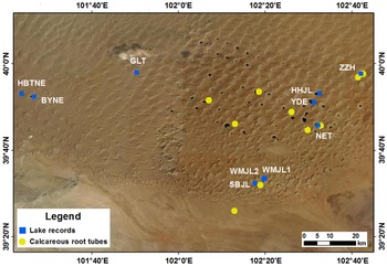
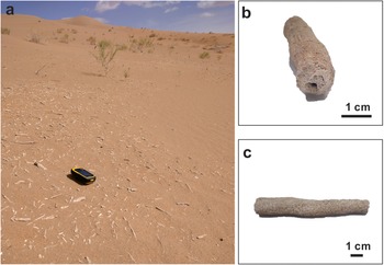
The evolution of some of the lakes in the southeast area of the Badain Jaran Desert (Fig. 2) during the Holocene has previously been reconstructed (Yang et al., Reference Yang, Ma, Dong, Zhu, Xu, Ma and Liu2010; Wang et al., Reference Wang, Ning, Li, Wang, Jia and Ma2016; Chen et al., Reference Chen, Lai, Liu, Wang, Wang, Miao, An, Yu and Han2019; Ning et al., Reference Ning, Wang, Lv, Li, Sun, An and Zhang2019). In this region, CRTs are mainly scattered horizontally on the surfaces of the sand layers at different altitudes of the megadunes (Fig. 3a). These CRTs record regional precipitation and effective moisture conditions in the desert (Li et al., Reference Li, Wang, Li, Ning, Cheng and Zhao2015b). In the swale around the interdune lakes, the soil moisture content was previously found to be higher than in the megadunes and interdune depressions. CRTs located in these areas usually contain local soil moisture, which is unsuitable for regional paleoclimate reconstruction studies (Li et al., Reference Li, Wang, Li, Ning, Cheng and Zhao2015b; Sun et al., Reference Sun, Huguet and Zamanian2021). Therefore, we collected CRT samples at different elevations of the megadunes (Fig. 2). The proxy records from these samples may indicate regional climatic conditions. The spatial distribution of the sample sites is consistent with the location of most of the perennial lakes, as can be seen in the remote sensing image (Fig. 2).
Locations of the Holocene calcareous root tubes (CRTs) sampled and lake records from the southeastern Badain Jaran Desert. Yellow dots indicate the Holocene CRT sample locations in the Badain Jaran Desert. Blue squares are the high lake-level records from previous studies. These records are abbreviated as follows: HBTNE, Habutenuoer (Wang et al., Reference Wang, Ning, Li, Wang, Jia and Ma2016); BYNE, Bayannuoer (Wang et al., Reference Wang, Ning, Li, Wang, Jia and Ma2016); GLT, Gailite (Wang et al., Reference Wang, Ning, Li, Wang, Jia and Ma2016); ZZH, Zhunzhahanjilin (Ning et al., Reference Ning, Wang, Lv, Li, Sun, An and Zhang2019); HHJL, Huhejilin (Yang and Williams, Reference Yang and Williams2003); YDE, Yindeer (Chen et al., Reference Chen, Lai, Liu, Wang, Wang, Miao, An, Yu and Han2019); NET, Nuoertu (Yang et al., Reference Yang, Ma, Dong, Zhu, Xu, Ma and Liu2010); WMJL1 and 2, Womenjilin 1 and 2 (Chen et al., Reference Chen, Lai, Liu, Wang, Wang, Miao, An, Yu and Han2019); SBJL, Shaobaijilang (Yang et al., Reference Yang, Ma, Dong, Zhu, Xu, Ma and Liu2010).

Distribution and morphology of calcareous root tubes (CRTs) in the Badain Jaran Desert: (a) CRTs are scattered horizontally on the surfaces of sand layers at different altitudes of the megadunes; (b and c) morphological characteristics of CRTs.

Most CRTs have a tubular morphology with a central void formed by the cementation of white carbonate minerals, predominantly calcite (Fig. 3b). The CRTs vary in length from a few cm to more than 100 cm, and their diameters range from 0.2 to 3.2 cm (Fig. 3c). The surface of all sampling sites is covered by >1 m of eolian sand, which had a median sand particle size of 0.2–0.4 mm.
Chronology
The results of 14C dating of pedogenic carbonate can be affected by various factors, such as recrystallization and incorporation of older and younger carbon (Gocke et al., Reference Gocke, Pustovoytov, Kühn, Wiesenberg, Löscher and Kuzyakov2011; Li et al., Reference Li, Zhu, Gao, Chim and Liao2020b). The carbon source for CRTs is a mixture of soil CO2 derived from root respiration and atmospheric CO2 (Gao et al., Reference Gao, Li, Zhu and Liao2020a). Li et al. (Reference Li, Wang, Cheng, Ning, Zhao and Li2015a) determined that the incorporation of older carbon slightly influenced 14C ages for CRT samples from the Badain Jaran Desert. The age difference between the CRTs and aquatic mollusk shells from the desert was less than 300 years, indicating that the Holocene 14C dates for the CRTs are robust at the millennial scale (Li et al., Reference Li, Wang, Cheng, Ning, Zhao and Li2015a). This is consistent with the results previously reported by Pustovoytov et al. (Reference Pustovoytov, Schmidt and Parzinger2007) and Gocke et al. (Reference Gocke, Pustovoytov, Kühn, Wiesenberg, Löscher and Kuzyakov2011). Li et al. (Reference Li, Zhu, Gao, Chim and Liao2020b) showed that the inner precipitated carbonate layer of the CRTs was not affected by recrystallization. Therefore, carbonate from the inner belt of CRTs is a suitable material for 14C dating.
In this study, we collected carbonate from the inner belt of five recently collected CRT samples, which were then dated via accelerator mass spectrometry (AMS) radiocarbon analysis. During pretreatment, ultrasonic cleaners were used to remove small amounts of carbonate attached to the exteriors of the CRT samples. AMS 14C dating was conducted at the Laboratory of Scientific Archaeology and Preservation of Cultural Relics, School of Archaeology and Museology, Peking University, China. All radiocarbon ages were converted to calendar year ages using the IntCal20 model of the Calib 8.2 program (Reimer et al., Reference Reimer, Austin, Bard, Bayliss and Talamo2020).
Major elements analysis
The concentrations of major elements in our bulk samples of CRTs were determined by X-ray fluorescence (XRF) spectrometry at the Key Laboratory of Western China's Environmental System, Lanzhou University. The samples were powdered and sifted through a 200-mesh screen, and 4 g of each sample was poured into the center of a column apparatus with boric acid and pressurized for 20 s using the YYJ-40 semiautomatic oil hydraulic apparatus. The compressed samples were approximately 4 cm in diameter and 0.8 cm thick. They were then measured by XRF spectrometry (Panalytical Magix PW2403, Netherlands).
Analytical results for major elements were reported in the form of oxide compound concentrations. The accuracy and precision of the result of the XRF method met the analysis requirements, which have been described by Gao et al. (Reference Gao, Li, Wang and Li2019). The results of element analysis for the samples were compared with standard values from GBW07401 (GSS-1). The repeatability for major element analysis was estimated by the standard deviation of triplicate measurements. The standard deviations were <4% for CaO and MgO.
Phytolith extraction and classification
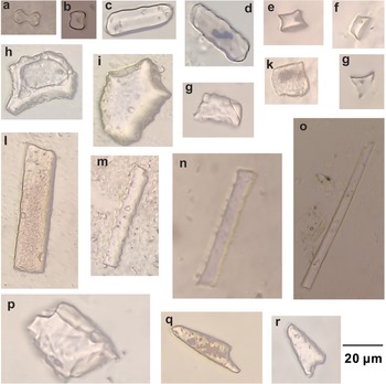
Phytolith extraction from CRTs followed the wet ashing procedure, as reported in Gao et al. (Reference Gao, Li, Zhu and Wang2020b). Phytolith counting and identification were performed using a microscope (Shanghai Changfang Optical Instrument Co., China) at 400× magnification. Each sample contained more than 300 phytoliths. Phytolith abundance was described as a percentage of the total number of phytoliths. The phytoliths were divided into 14 types based on the classification systems of several previous studies (Twiss et al., Reference Twiss, Suess and Smith1969; Lu et al., Reference Lu, Wu, Yang, Jiang, Liu and Liu2006, Reference Lu, Wu, Liu, Jiang and Liu2007; Gao et al., Reference Gao, Li, Zhu and Wang2020b) and international phytolith nomenclature (ICPN2.0; ICPT, 2019) (Fig. 4). The corresponding ICPN2.0 nomenclature is placed in brackets after each morphotype: (1) dumbbell (BILOBATE), (2) short-saddle (SADDLE), (3) wavy-narrow-trapezoid (TRAPEZOID), (4) rondel (RONDEL), (5) fan-reed (BULLIFORM FLABELLATE), (6) fan (BULLIFORM FLABELLATE), (7) square (BLOCKY), (8) rectangle (TABULAR ENTIRE), (9) board-elongate (ELONGATE ENTIRE), (10) sinuate-elongate (ELONGATE SINUATE), (11) smooth-elongate (ELONGATE ENTIRE), (12) long-point (ACUTE BULBOSUS), (13) short-point (ACUTE BULBOSUS), and (14) gobbet (BLOCKY).
Phytolith morphotypes identified from the CRT samples in the Badain Jaran Desert. The ICPN2.0 nomenclature is placed within brackets after each morphotype: (a) dumbbell (BILOBATE), (b) short-saddle (SADDLE), (c and d) wavy-narrow-trapezoid (TRAPEZOID), (e–g) rondel (RONDEL), (h) fan (BULLIFORM FLABELLATE), (i) fan-reed (BULLIFORM FLABELLATE), (j) rectangle (TABULAR ENTIRE), (k) square (BLOCKY), (l) board-elongate (ELONGATE ENTIRE), (m and n) sinuate-elongate (ELONGATE SINUATE), (o) smooth-elongate (ELONGATE ENTIRE), (p) gobbet (BLOCKY), (q) long-point (ACUTE BULBOSUS), and (r) short-point (ACUTE BULBOSUS).

Effective moisture and quantitative precipitation reconstructions
The Mg/Ca ratio in CRTs is considered a proxy for effective moisture (Gao et al., Reference Gao, Li, Wang and Li2019). In arid regions, the transport of soil solutions may trigger CO2 degassing under high evaporation rates, promoting prior calcite precipitation (McDonald et al., Reference McDonald, Drysdale and Hill2004; Cruz et al., Reference Cruz, Burns, Jercinovic, Karmann, Sharp and Vuille2007). Thus, according to the Rayleigh distillation, the correlation between the Mg/Ca ratio and residual Ca in soil solution is negative (Gao et al., Reference Gao, Li, Wang and Li2019). Therefore, a higher effective moisture and soil water content in the desert would result in higher actual evaporation and more Ca would be precipitated from the soil solution, resulting in an increase in the Mg/Ca ratios in the residual soil solution and an increase in the Mg/Ca ratios in the CRTs (Gao et al., Reference Gao, Li, Wang and Li2019). Accordingly, a higher Mg/Ca ratio corresponds to higher effective moisture, and vice versa (Gao et al., Reference Gao, Li, Wang and Li2019; Zhu et al., Reference Zhu, Li, Gao, Chen and Yu2019). Recrystallization occurring in the CRT detrital layer may result in geochemical changes in the bulk CRT samples (Li et al., Reference Li, Zhu, Gao, Chim and Liao2020b). However, this has little effect on paleoenvironmental reconstruction results when the Mg/Ca ratios in CRTs are used as a proxy (Li et al., Reference Li, Zhu, Gao, Chim and Liao2020b).
Phytoliths are noncrystalline SiO2 minerals deposited in and between plant cells that can be preserved in soil and sediment for long periods after plants die and decay (Webb and Longstaffe, Reference Webb and Longstaffe2000; Piperno, Reference Piperno2006; Zuo et al., Reference Zuo, Lu, Li and Song2021). Some plants produce distinctive and diagnostic phytolith types that can indicate special climatic conditions (Wang and Lu, Reference Wang and Lu1993; Prebble et al., Reference Prebble, Schallenberg, Carter and Shulmeister2002; Esteban et al., Reference Esteban, Albert, Eixea, Zilhão and Villaverde2017). Phytoliths from surface soil samples have already revealed that the distribution of some common phytolith types was affected by climatic conditions (Strömberg, Reference Strömberg2004; Lu et al., Reference Lu, Wu, Yang, Jiang, Liu and Liu2006; Biswas et al., Reference Biswas, Ghosh, Agrawal, Morthekai, Paruya, Mukherjee, Bera and Bera2021). In warm and humid conditions, some phytolith types such as square, rectangle, and fan types have high percentages; whereas in cold and arid conditions, elongate, point, trapezoid, and rondel phytolith types have high percentages (Wang et al., Reference Wang, Liu and Zhou2003; Zuo et al., Reference Zuo, Lu, Li and Song2021). Therefore, phytolith assemblages from various archives have been used to reconstruct paleoclimates (Horrocks et al., Reference Horrocks, Deng, Ogden and Sutton2000; Blinnikov et al., Reference Blinnikov, Busacca and Whitlock2002; Carter, Reference Carter2002; Zuo et al., Reference Zuo, Lu, Li, Song, Xu, Zou, Wang, Huan and He2016; Liu et al., Reference Liu, Gu, Huang, Yu, Xie and Cheng2019). Phytoliths within CRTs originated from local surface vegetation during CRT formation (Gao et al., Reference Gao, Li, Zhu and Wang2020b). Using the phytolith-precipitation transfer function, phytolith assemblages can be used to reconstruct Holocene millennial-scale precipitation (Lu et al., Reference Lu, Wu, Yang, Jiang, Liu and Liu2006; Gao et al., Reference Gao, Li, Zhu and Wang2020b).
The transfer function method used 238 surface-sediment samples along broad ecological and climatic gradients across China as the training set (Lu et al., Reference Lu, Wu, Yang, Jiang, Liu and Liu2006). MAP values were inferred quantitatively using a unimodal response model in R with the rioja package, which is based on weighted-average partial least squares regression and calibration (ter Braak and Juggins, Reference ter Braak and Juggins1993) using C2 v. 1.3 (Juggins, Reference Juggins2003). The results showed that phytoliths provide robust estimates of MAP (R 2-boot = 0.90, root mean-square error of prediction = 148 mm). Then, to clarify whether the training set from the whole of China could be applied to arid or semiarid areas, the 30 sites within the surface-sediment training set from Lu et al. (Reference Lu, Wu, Yang, Jiang, Liu and Liu2006) were used in the model to simulate results with precipitation of less than 300 mm. There was a relatively high correlation coefficient between the simulated MAP and the deviation (y = 0.747*x − 95.520, R 2 = 0.622, P < 0.01) (Gao et al., Reference Gao, Li, Zhu and Wang2020b), which can be used for model correction of Lu et al. (Reference Lu, Wu, Yang, Jiang, Liu and Liu2006). After optimization, the new standard errors of the quantitative precipitation reconstruction results were between 37 and 39 mm. This transfer function has been confirmed as suitable when using phytolith assemblages from CRTs in this region to quantitatively reconstruct Holocene millennial-scale precipitation (Gao et al., Reference Gao, Li, Zhu and Wang2020b).
In this study, the transfer functions were applied to 10 phytolith assemblages from CRTs in the desert. First, phytolith assemblages from 238 surface-sediment sites were used for model training (Lu et al., Reference Lu, Wu, Yang, Jiang, Liu and Liu2006). Second, quantitative precipitation reconstructions of the desert were achieved using the rioja package in R (Juggins, Reference Juggins2003). Finally, the regression equation of Gao et al. (Reference Gao, Li, Zhu and Wang2020b) (y = 0.747*x − 95.520) was used to optimize the reconstructed MAP.
RESULTS
14C dating
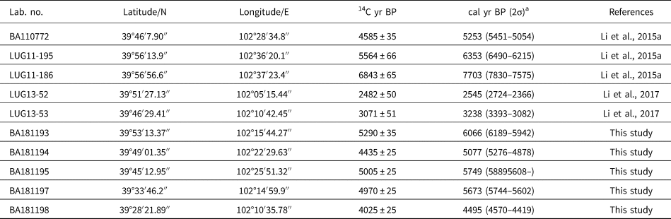
We have dated 21 CRT samples from the Badain Jaran Desert in our previous studies (Li et al., Reference Li, Wang, Cheng, Ning, Zhao and Li2015a; Li et al., Reference Li, Gao and Han2017) and this study. According to radiocarbon dating, 11 CRT samples dated to the late Pleistocene (Li et al., Reference Li, Wang, Cheng, Ning, Zhao and Li2015a), and 10 samples dated to the Holocene. The 14C dating results of the 10 Holocene CRT samples (Fig. 2; Table 1) yielded a range of dates, with one sample older than 7000 cal yr BP, six samples dated to 7000–5000 cal yr BP, and three samples dated to 5000–2000 cal yr BP (Table 1).
14C dates for the Holocene CRT samples collected in the Badain Jaran Desert.

a The calibrated 14C ages (2σ) were all calculated using Calib v. 8.2 (http://calib.org/calib/calib.html).
Mg/Ca ratio variation and effective moisture reconstruction
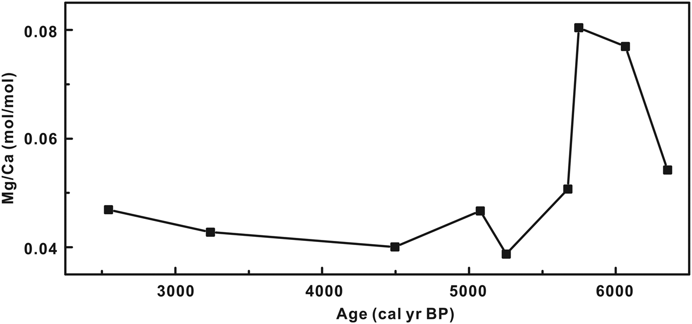
XRF results revealed that the Mg/Ca ratio values had fluctuated between 7000 and 5000 cal yr BP, with an average ratio value of 0.058 mol/mol (Fig. 5). Although the Mg/Ca ratio increased slightly between 5000 and 2000 cal yr BP, with an average of 0.043 mol/mol, it remained significantly lower than the values at 7000–5000 cal yr BP (Fig. 5). Thus, based on the environmental significance of the Mg/Ca ratio, higher effective moisture conditions occurred during 7000–500 cal yr BP and lower effective moisture conditions during 5000–2000 cal yr BP.
Changes in Mg/Ca ratio from calcareous root tubes (CRTs) in the Badain Jaran Desert during 7000–2000 cal yr BP.

Phytolith assemblage variation and quantitative precipitation reconstruction
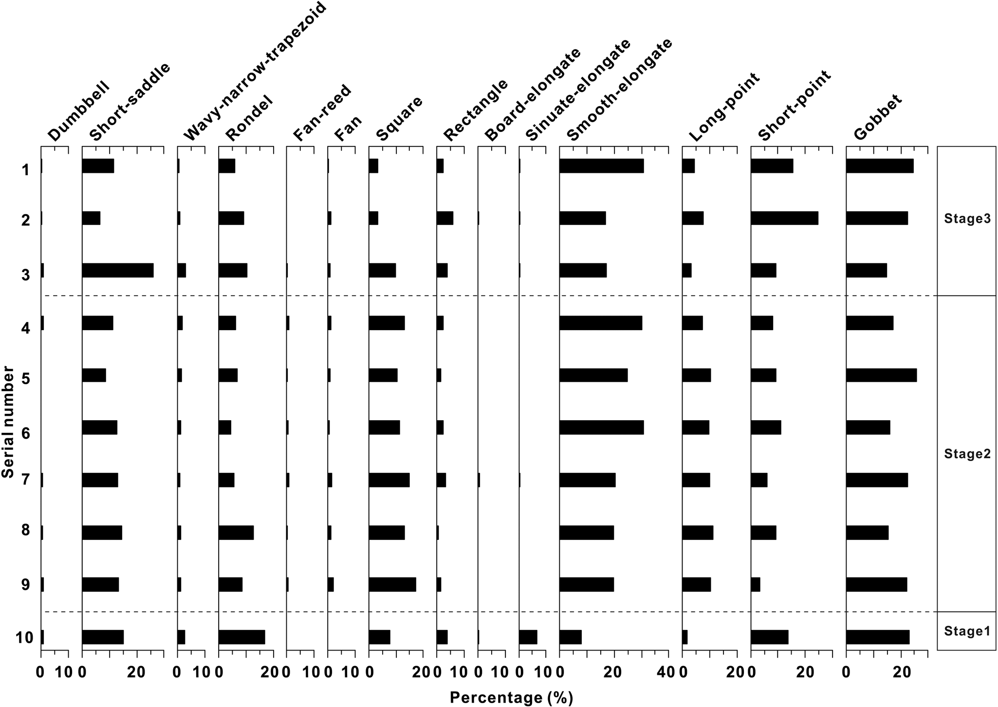
The 14 phytolith types and the variations in abundance in the 10 CRT samples are summarized in Figures 4 and 6. The major phytolith types included smooth-elongate, gobbet, short-saddle, square, short-point, long-point, rondel, rectangle, wavy-narrow-trapezoid, and fan types. The relative abundance of these types was higher than 1%. The phytolith assemblage characteristics and quantitative precipitation reconstructions in the Badain Jaran Desert during the Holocene are described in the following paragraphs.
Relative abundance of phytoliths observed from calcareous root tube (CRT) samples in the Badain Jaran Desert. Stages 1, 2, and 3 indicate before 7000 cal yr BP, 7000–5000 cal yr BP, and 5000–2000 cal yr BP, respectively.

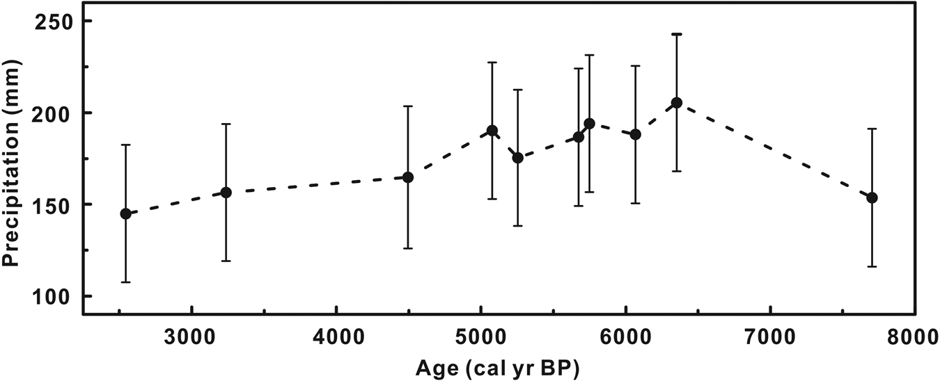
Stage 1 (before 7000 cal yr BP): The phytolith assemblages were dominated by gobbet types (23%). The percentage contents of rondel (17%), short-saddle (15%), short-point (14%), smooth-elongate (8%), square (8%), and sinuate-elongate (7%) types were relatively high, whereas the percentage contents of rectangle (4%), wavy-narrow-trapezoid (3%), and long-point (2%) types were relatively low (Fig. 6). The relative abundance of the other types was less than 1% (Fig. 6). The distribution of phytolith assemblages reflected a relatively arid climate. Based on the phytolith–precipitation transfer function, the reconstructed MAP was 154 ± 38 mm during this period (Fig. 7).
Phytolith-based quantitative reconstructions of millennial-scale precipitation changes in the Badain Jaran Desert during the Holocene.

Stage 2 (7000–5000 cal yr BP): The phytolith assemblages were dominated by smooth-elongate (23 ± 5%) and gobbet (19 ± 4%) types. The percentage contents of short-saddle (14 ± 6%), square (13 ± 3%), long-point (9 ± 3%), short-point (8 ± 3%), and rondel (8 ± 3%) types were relatively high, whereas rectangle (2 ± 1%), wavy-narrow-trapezoid (1 ± 1%), and fan (1 ± 1%) types were relatively low (Fig. 6). The relative abundance of the other types was less than 1% (Fig. 6). The distribution of phytolith assemblages reflected a relatively humid climate. Based on the phytolith–precipitation transfer function, the reconstructed MAP was 175 ± 37 to 205 ± 37 mm during this period (Fig. 7).
Stage 3 (5000–2000 cal yr BP): The phytolith assemblages were also dominated by smooth-elongate (24 ± 10%) and gobbet (24 ± 2%) types, but relative abundance increased compared with stage 2 (Fig. 6). The percentage of short-point types (20 ± 7%) increased significantly, whereas the short-saddle (9 ± 4%), rondel (8 ± 2%), long-point (6 ± 2%), and square (3 ± 1%) types declined (Fig. 6). The percentage of rectangle types (4 ± 3%) increased slightly (Fig. 6). The relative abundance of the other types was less than 1% (Fig. 6). The distribution of phytolith assemblages reflected a relatively arid climate compared with the period between 7000 and 5000 cal yr BP. Based on the phytolith–precipitation transfer function, the reconstructed MAP was 145 ± 37 to 165 ± 39 mm (Fig. 7).
DISCUSSION
Comparison of climate change and lake evolution
Relatively high effective soil moisture is conducive to the formation of CRTs and was a controlling factor for CRT formation in the Badain Jaran Desert (Li et al., Reference Li, Wang, Cheng, Ning, Zhao and Li2015a). The distribution frequency of CRTs showed relatively few CRTs before 7000 cal yr BP (Li et al., Reference Li, Wang, Li, Ning, Cheng and Zhao2015b), which indicates an relatively arid environment with low effective soil moisture that was not suitable for the formation of CRTs. The MAP was approximately 154 ± 38 mm during this period (Fig. 7). Moreover, in the Tengger Desert, located to the southeast of the Badain Jaran Desert (Fig. 1), a low frequency of CRT distribution occurred in the corresponding period (Li et al., Reference Li, Wang, Li, Ning, Cheng and Zhao2015b). The quantitative reconstruction of precipitation showed that the MAP in the period 10,000–7000 cal yr BP (138 ± 16 to 149 ± 18 mm) was 40 mm less than in the period 7000–5000 cal yr BP (179 ± 26 to 192 ± 26 mm) (Gao et al., Reference Gao, Li, Zhu and Wang2020b). In addition, the accumulation of loess on the southeastern margin of the Badain Jaran Desert also indicated low effective moisture during this period (Gao et al., Reference Gao, Tao, Li, Jin, Zou, Zhang and Dong2006). These results are evidence of a relatively arid climate before 7000 cal yr BP.
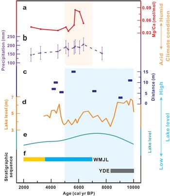
A millennial-scale climate reconstruction of the Badain Jaran Desert suggested a relatively humid climate during 7000–5000 cal yr BP, and the MAP was 175 ± 37 to 205 ± 37 mm (Fig. 8a and b). During 5000–2000 cal yr BP, the effective moisture was low, with a MAP of 145 ± 37 to 165 ± 39 mm (Fig. 8a and b), and the climate became relatively arid.
The comparison of climate changes and lake evolution in the Badain Jaran Desert during the Holocene: (a) changes in Mg/Ca ratio from calcareous root tubes (CRTs) at the millennial scale (this study); (b) quantitative precipitation reconstructions revealed by phytolith assemblages (this study); (c) lake-level elevation above the present water surface (Yang et al., Reference Yang, Ma, Dong, Zhu, Xu, Ma and Liu2010), the record contained Huhejilin, Nuoertu, and Shaobaijilang lakes; (d) the quantitatively reconstructed consecutive paleolake-level fluctuations from Zhunzhahanjilin (ZZH) section (Dong et al., Reference Dong, Li, Li, Lu, Wang and Ning2022); (e) high lake levels during the Holocene in the Badain Jaran Desert, including records for Habutenuoer (HBTNE), Bayannuoer (BYNE), and ZZH lakes (Wang et al., Reference Wang, Ning, Li, Wang, Jia and Ma2016); and (f) stratigraphic sequence for the Yindeer (YDE) and Womenjilin (WMJL) sections in the Badain Jaran Desert (Chen et al., Reference Chen, Lai, Liu, Wang, Wang, Miao, An, Yu and Han2019): orange represents eolian deposits, blue represents lacustrine deposits, and gray represents gyttja deposits. The pink shadow indicates the humid climate during the Middle Holocene. The blue shadow indicates the lakes with high levels during the Early and Middle Holocene.

However, Holocene lake evolution in the Badain Jaran Desert is not fully consistent with our effective moisture and precipitation reconstruction results (Fig. 8). Previous studies revealed that the lake levels were relatively high during the Early and Middle Holocene. In the southeastern margin of the desert (Yang et al., Reference Yang, Liu and Xiao2003, Reference Yang and Scuderi2010), at 10,000–4000 cal yr BP, the water levels of the lakes were approximately 2–15 m above the present water level (Fig. 8c). The quantitative reconstruction of the consecutive paleolake-level fluctuations from the Zhunzhahanjilin (ZZH) section indicated that high lake levels occurred between 10,600–4700 cal yr BP with fluctuations of 3.41–9.21 m (Dong et al., Reference Dong, Li, Li, Lu, Wang and Ning2022). Wang et al. (Reference Wang, Ning, Li, Wang, Jia and Ma2016) revealed that many lakes in the desert hinterland reached their maximum water levels during the period 8600–6300 cal yr BP (Fig. 8e). Moreover, Chen et al. (Reference Chen, Lai, Liu, Wang, Wang, Miao, An, Yu and Han2019) proposed that lakes were developing in the desert during the period 10.7–3.6 ka (Fig. 8f). The incomplete synchronization between lake evolution and climate change indicates that lake evolution may be influenced not only by climatic factors but also by non-climatic factors.
Factors influencing lake evolution in the Badain Jaran Desert
Fluctuations in the depths and areas of inland lakes usually provide significant evidence of the water budget, which is directly linked to atmospheric precipitation. However, there is a different water budget for lakes located in the desert hinterlands and other inland regions. First, there was no direct surface runoff flowing into the lakes in the Badain Jaran Desert hinterland (Dong et al., Reference Dong, Wang, Chen, Li, Chen, Chen and Ma2016). Second, there is evidence that atmospheric precipitation did not contribute significantly to the groundwater system (Ma et al., Reference Ma, Wang, Zhao, Zhang, Dong and Shen2014). Third, measures of evaporation and estimated water balance indicate that groundwater recharge contributed a much greater portion of the total lake replenishment (Dong et al., Reference Dong, Wang, Chen, Li, Chen, Chen and Ma2016; Sun et al., Reference Sun, Hu, Wang, Zhao, An, Ning and Zhang2018). As a result, the amount of groundwater recharge drives changes in lake levels in the desert hinterland (Wu et al., Reference Wu, Wang, Zhao, Zhang, Chen, Lu, Lü and Chang2014; Dong et al., Reference Dong, Wang, Chen, Li, Chen, Chen and Ma2016). Although there is an ongoing debate regarding the origin of groundwater (Yang et al., Reference Yang, Liu and Xiao2003; Chen et al., Reference Chen, Li, Wang, Barry, Sheng, Gu, Zhao and Chen2004; Ma and Edmunds, Reference Ma and Edmunds2006; Gates et al., Reference Gates, Edmunds, Darling, Ma, Pang and Young2008; Shao et al., Reference Shao, Zhao, Zhou, Dong and Ma2012; Dong et al., Reference Dong, Wang, Chen, Li, Chen, Chen and Ma2016), deep phreatic water is likely the main replenishment source. Therefore, lake-level fluctuations in the desert must be influenced by a combination of atmospheric precipitation, evaporation, and groundwater recharge.
During the Holocene, lake levels in the study area increased before 7000 cal yr BP (Yang et al., Reference Yang, Liu and Xiao2003, Reference Yang, Ma, Dong, Zhu, Xu, Ma and Liu2010; Wang et al., Reference Wang, Ning, Li, Wang, Jia and Ma2016), but the precipitation was relatively low, resulting in a relatively arid climate. At the same time, high solar insolation resulted in high temperatures (Berger and Loutre, Reference Berger and Loutre1991), which could have led to increased evaporation. This climate condition was not beneficial for the lake-level increase. Thus, the high lake levels during this period were probably influenced by the increase in groundwater recharge. High temperatures could increase meltwater in the lake recharge areas, such as the Qilian Mountains and the Qinghai-Tibet Plateau, which recharged the lakes with groundwater, causing a rise in lake levels in the desert hinterland. Li et al. (Reference Li, Wang, Cheng and Li2016b) have shown that abundant runoff occurred in the western Qilian Mountains during the Early Holocene (10,500–8800 cal yr BP). Wünnemann et al. (Reference Wünnemann, Wagner, Zhang, Yan, Wang, Shen, Fang and Zhang2012) also suggested that, in the case of Hala Lake in the period between 10,000 and 9500 cal yr BP, stepwise lake-level rise was most likely a response to intense glacier melt in the Qilian Mountains. Moreover, there is also evidence of meltwater from glaciers resulting in abundant runoff and lake-level rise in the Qinghai-Tibet Plateau (Gyawali et al., Reference Gyawali, Wang, Ma, Wang, Xu, Guo and Zhu2019; Hou et al., Reference Hou, Long, Shen and Gao2021). These studies provide evidence of abundant meltwater before 7000 cal yr BP. Thus, a rise in lake levels before 7000 cal yr BP can be attributed to an increase in meltwater transformed to groundwater, which then recharged the lakes.
In the present study, quantitative precipitation reconstruction results showed that the MAP reached 175 ± 37 to 205 ± 37 mm in the period 7000–5000 cal yr BP, which is approximately twice the current precipitation level. During this period, many lakes reached their highest levels (Yang et al., Reference Yang, Liu and Xiao2003, Reference Yang, Ma, Dong, Zhu, Xu, Ma and Liu2010, Reference Yang, Scuderi, Paillou, Liu, Li and Ren2011; Wang et al., Reference Wang, Ning, Li, Wang, Jia and Ma2016; Chen et al., Reference Chen, Lai, Liu, Wang, Wang, Miao, An, Yu and Han2019), and evaporation decreased with the decline in solar insolation (Berger and Loutre, Reference Berger and Loutre1991). Our results also revealed a humid environment with high effective moisture and precipitation during this period (Fig. 8). Therefore, the lake-level fluctuations were consistent with the effective moisture and precipitation at 7000–5000 cal yr BP. However, whether the increase in groundwater recharge led to synchronous increases in lake levels requires further study.
After 5000 cal yr BP, precipitation and effective moisture decreased (Fig. 8a and b), resulting in an arid environment. Under these circumstances, lake levels declined (Yang et al., Reference Yang, Ma, Dong, Zhu, Xu, Ma and Liu2010, Reference Yang, Scuderi, Paillou, Liu, Li and Ren2011; Wang et al., Reference Wang, Ning, Li, Wang, Jia and Ma2016; Chen et al., Reference Chen, Lai, Liu, Wang, Wang, Miao, An, Yu and Han2019).
Thus, lake evolution in the desert hinterland during the Holocene was influenced by precipitation, evaporation, and groundwater recharge. Before 7000 cal yr BP, lake-level rise can be attributed to an increase in meltwater flowing into the groundwater in the lake recharge areas. In other periods, lake-level fluctuations are sensitive to climate change between arid and humid environments.
Mechanisms possibly forcing climate changes
The study area is located in the Asian monsoon margin of NW China (Li et al., Reference Li, Wei, Zhou and Tian2020a). In this region, precipitation and effective moisture changes at the millennial scale during the Holocene differed from those observed in the typical monsoon region (Li et al., Reference Li, Wang, Li, Ning, Cheng and Zhao2015b; Gao et al., Reference Gao, Li, Zhu and Liao2020a, Reference Gao, Li, Zhu and Wang2020b). Precipitation during the Early and Middle Holocene in this region was affected by changes in the northernmost margin of the Asian summer monsoon (Lu et al., Reference Lu, Miao, Zhou, Mason, Swinehart, Zhang, Zhou and Yi2005; Gao et al., Reference Gao, Li, Zhu and Wang2020b).
Before 7000 cal yr BP, with increased insolation (Berger and Loutre, Reference Berger and Loutre1991), the Asian summer monsoon reached its greatest intensity (Dykoski et al., Reference Dykoski, Edwards, Cheng, Yuan, Cai, Zhang, Lin, Qing, An and Revenaugh2005; Wang et al., Reference Wang, Cheng, Edwards, He, Kong, An, Wu, Kelly, Dykoski and Li2005). However, because of the suppression of the high-latitude ice sheet (Dyke, Reference Dyke2004; Peltier, Reference Peltier2004), the global sea level was lower during this period. The East Asian continental shelf was exposed to the surface, increasing the distance of moisture transported from the ocean to inland (Liu et al., Reference Liu, Milliman, Gao and Cheng2004; Dutton and Lambeck, Reference Dutton and Lambeck2012; Li et al., Reference Li, Li, Liu, Qiao, Ma, Xu and Yang2014). Therefore, the northernmost margin of the Asian summer monsoon stalled farther south (Wen et al., Reference Wen, Xiao, Fan, Zhang and Yamagata2017; Gao et al., Reference Gao, Li, Zhu and Wang2020b). Furthermore, the highest temperatures occurred in the Early Holocene (Long et al., Reference Long, Lai, Wang and Li2010), leading to increased evaporation. Therefore, the Asian monsoon margin area had an arid climate with low precipitation before 7000 cal yr BP. During the Middle Holocene, with the decline of insolation and the disappearance of the ice sheet at high latitudes around 7 ka (Peltier, Reference Peltier2004), the northernmost edge of the Asian summer monsoon moved northward, and monsoon precipitation increased. Moreover, low evaporation resulting from low winter solar radiation and high summer cloud cover in Central and East Asia could have led to an increase in effective moisture during this period (Li and Morrill, Reference Li and Morrill2010). Therefore, a more humid environment, with higher monsoon precipitation and lower evaporation, occurred during this period.
With the decline of insolation, the intensity of the Asian summer monsoon weakened, and monsoon precipitation decreased in the Late Holocene, eventually producing a relatively arid environment.
CONCLUSIONS
Mg/Ca ratios and phytolith assemblages in Holocene CRTs from the Badain Jaran Desert were used to reconstruct changes in effective moisture and MAP, respectively, at the millennial scale during the Holocene. Before 7000 cal yr BP, the reconstructed MAP was 154 ± 38 mm, indicating a relatively arid environment. The effective moisture was high, with a MAP of 175 ± 37 to 205 ± 37 mm (twice the current precipitation) during 7000–5000 cal yr BP. However, the effective moisture decreased, with a MAP of 145 ± 37 to 165 ± 39 mm between 5000–2000 cal yr BP.
Holocene lake evolution in the desert is not fully consistent with effective moisture and monsoon precipitation changes. Lake-level fluctuations are influenced by precipitation, evaporation, and groundwater recharge. Before 7000 cal yr BP, the rise in lake levels can be attributed to an increase in groundwater recharge that likely originated from meltwater in the recharge area. During other periods, lake-level fluctuations were coupled with climate changes between arid and humid environments. During 7000–5000 cal yr BP, high lake levels correspond to increased monsoonal precipitation and groundwater recharge. The gradual decline of lake levels during 5000–2000 cal yr BP reflected a relatively arid climate with decreased monsoonal precipitation and groundwater recharge.
Acknowledgments
The authors thank two anonymous reviewers as well as Derek Booth and Xiaoping Yang for their constructive comments, which led to the significant improvement of this article. This study was supported by the National Natural Science Foundation of China (no. 41771211) and the Special Fund of Chinese Central Government for Basic Scientific Research Operations in Commonweal Research Institutes (no. SK202105).