

Information as a source of central government power has long been a theme in the historiography of the nineteenth century.Footnote 1 The subject also has salience for public policy history, a major theme in which is the trend toward centralizing of government power. Since territory is a defining component of the state, how can a state know its territory and its internal delimitation: a vital prerequisite for the precise application of policy? This article examines a particular instance of the extension of state power through control of information in the form of cartographic knowledge. The specific focus is the Ordnance Survey’s survey of administrative boundaries in England and Wales, undertaken between 1841 and 1889 alongside its large-scale mapping survey. This was an era of great change in Britain; industrialization and urbanization continued apace and changes in forms of local administration were seen as necessary to cope with it. Thus the article explores the context in which central government was able to initiate its policy objectives with regard to gaining knowledge of and reshaping the internal boundaries of the local state, and the significance of such a policy.
Although the Ordnance Survey was founded in 1791, this article will concentrate on the mid-nineteenth century period, after it was placed on a statutory footing and began to produce detailed maps, principally for civilian uses. The original military role of the Ordnance Survey clearly involved a motive of strengthening knowledge of the territory in the interests of efficient organization and knowledge of the internal space of the state.Footnote 2 This study concentrates on the mature phase of Ordnance Survey activity when it began to record local administrative areas in reliable and minute detail on large-scale maps.
This article asks how we should characterize the Ordnance Survey’s role in first recording the traditional local administrative boundaries of the United Kingdom and then aiding the articulation of a system of local government with rationalized spatial expression. Where did the Ordnance Survey “sit” between central government and the localities? Did the Boundary Survey (henceforth referred to as the OSBS) serve to further a possible standardizing agenda of central government in the mid- to late nineteenth century? Did the Ordnance Survey’s definitive survey of public boundaries represent an unsympathetic intrusion by central government upon the localities? After all, it might be supposed that mapping is one of the most intrusive forms of information gathering that the state or any other body could undertake. What kind of new administrative geography emerged in the nineteenth century and what was the Ordnance Survey’s role in the process? An integrated system of local government developed, where arguably none had existed before, with many new functions such as poor-law unions, registration, and sanitary districts. All used the framework set by the ancient territorial units as building blocks and thus how much innovation was involved? The case study thus provides an examination of British state policy on the development of its knowledge apparatus through the medium of mapping of local administrative boundaries.
The Ordnance Survey had to decide how carry out the task given by its Whitehall paymasters and set out in legislation of 1841, which established the organization on a statutory footing.Footnote 3 It is shown that the process was not simply one of top- down imposition, but also involved respect for tradition and local usages as well as reflecting the agenda of the mapmaker. The cartographic arm of central government through this particular extension of its knowledge apparatus laid bare the administrative geography of Britain. However, the distinctiveness and particularism of forms of local administration, especially in terms of their spatial manifestation, was not seriously eroded.
A useful reference point here is Scott, who sees “legibility as a central problem in statecraft.”Footnote 4 While his thesis treats twentieth-century large-scale utopian schemes designed to improve the human condition, some of his findings are instructive in the context of the present article. Scott makes a case against central planning that “excludes the necessary role of local knowledge and know-how.”Footnote 5 My argument illuminates this notion by proposing that the case of the OSBS suggests that nineteenth-century policymakers had the foresight to understand the inherent logic of Scott’s hindsight in the context of nineteenth-century Britain. I argue here that large-scale state-sponsored schemes, in this case administrative boundary mapping, are not necessarily incompatible with the use of local expertise and preference. Rather, I propose that such schemes were seen to benefit from the incorporation of local customary knowledge. Perhaps such wisdom receded amid the “big is beautiful” mentality characterizing parts of the twentieth century.
To this end, the Ordnance Survey was highly conscientious and painstaking in its execution of the Boundary Survey and arguably exceeded the minimal requirements set for it by the 1841 Act.Footnote 6 The boundaries were recorded in the minute detail the large-scale maps allowed. As well as meticulous, the Ordnance Survey was sensitive in its mode of proceeding. It provided a graphic backdrop to plan local government reform while respecting ancient traditional units of civil and ecclesiastical administration with painstaking detail and precision. Thus, at a time of great social and economic change, the Ordnance Survey carefully blended the possible requirements of central government for administrative efficiency with local preferences and customs, and with knowledge of boundaries gained from local sources since there was no central and comprehensive data on such matters. By maintaining the wider generally acknowledged excellence of its brand, the Ordnance Survey was able to secure its future as a state-funded mapping enterprise in an era generally hostile to central government sponsorship of such initiatives.
This sensitivity is appropriate given the predominantly liberal flavor of British politics in the mid-nineteenth century, where intrusions by the state upon local matters or private enterprise were not generally welcomed without very good cause. In this period, British political culture was plainly more democratic that authoritarian. This may help to explain why central government did not attempt to override local preference and why the Ordnance Survey mirrored such caution. The notion of local government has been significantly linked with wider notions of liberty and freedom. De Tocqueville remarked that a nation “without the spirit of municipal institutions . . . cannot have the spirit of liberty.”Footnote 7 If, in the process of recording the spatial domains of local administration, the Ordnance Survey compromised the localism of these units, then the government mapmaker might have played a role in transforming the relationship between central government and the localities. The present case study enhances our understanding of the way central government and the localities interrelated in the nineteenth century and how the Ordnance Survey acted as an intermediary in the development of a system of local government based on an ancient spatial framework.
The Modernization of the British State and Its Knowledge Apparatus in the Nineteenth Century
The nineteenth century witnessed the modernization of the British state in a number of respects. Fundamental to this article is an analysis of central government policy, as nuanced by the Ordnance Survey, for recording and reforming the myriad ancient units of local administration. To what extent was mapping intended to bring about this process and how should the effect of the Ordnance Survey’s cartographic record of the administrative geography of England and Wales be regarded? To some extent, the answers emerge from a study of mentalities and intentions of policymakers and officials. However, as I will show, the key players were not located only in Whitehall, but were to be found in the localities and also in the officers of the mapmaker: the Ordnance Survey itself.
As general context, it is necessary to examine the development of Britain’s knowledge apparatus in our period. David Eastwood documents central government’s growing appetite for information arguing that “the peculiar achievement of the English state by the mid nineteenth century was to have laid bare its soul . . . through its own bureaucratic productions.”Footnote 8 There was a growing interest in the early nineteenth century in statistical inquiries, sometimes styled as political arithmetic. There is a vast literature on information and state power to inform the context of this article. Notably, Higgs has analysed the growth of the Information State in England, and, importantly for this article, he shows that information-gathering need not wipe out local distinctiveness, finding that “Victorian official statistics . . . were used to reveal local differences rather than simply give a unitary picture of the nation.”Footnote 9 Higgs also finds that central information-gathering initiatives such as the census could underpin “homogenous representations that would consolidate the nation state.”Footnote 10 Thus central government information gathering is complex in its effect on the central-local power balance. I will show that as an agency of central government, the Ordnance Survey’s role in clarifying and reforming the spatial manifestation of local government areas still required, and arguably welcomed, local cooperation. This is understandable in the context of the development of information gathering in early modern England, which Higgs sees as a decentralized state in which surveillance occurred at the level of the locality.Footnote 11 Local administration did not amount to a coordinated system of local government but relied on local elites, as unpaid officers, entering into a pact with the center to run the localities, collect taxes, and feed certain information to London.
The specific element of the knowledge apparatus relevant to this article is maps. Theoretical statements of the link between maps and power allow an assessment of the potential role of the OSBS as a transformative tool of government policy, with maps as potentially part of the “authoritative resources of the state.”Footnote 12 Biggs argues that delimited territory is the basis of every sociological definition of the state and that “the formation of the modern state depicted on the map was constituted in part through cartography—as a store of knowledge reflecting surveys that rulers sponsored to penetrate the ground over which they ruled.”Footnote 13 This notion can be extended to the local state by examining the role of the Ordnance Survey in transforming the essence and composition of local administrative areas in England by mapping them. Biggs contends that “parallel to the demarcation of boundaries was the homogenization of territory.”Footnote 14
Much of the literature argues that maps are a means of perpetuating already-established power. In Maps, Knowledge, and Power, Brian Harley argues that “knowledge is a form of power, a way of presenting one’s own values in the guise of scientific disinterestedness,”Footnote 15 and that maps are such a form of knowledge and thus of power. Hence the mapmaker represents “the territorial imperatives of a particular political system.”Footnote 16 Central government policy on commissioning mapping of the national space through internal boundary delimitation can be examined in this light. Harley’s argument draws on Foucault in regarding some of the practical effects of maps as part of that author’s category of surveillance that would encompass the preservation of law and boundary making.Footnote 17
There are many similarly argued examinations of the connections between maps and power in a variety of contexts. Edney looks at the role of mapping in the construction of British India, finding that “to govern territories, one must know them.”Footnote 18 Brotton examines the use of maps to make claims to global authority and possession.Footnote 19 Monmonier sees maps as the perfect symbol of the state through the delimitation, naming, and coloring in of the area owned or claimed.Footnote 20 Buisseret also shows us the link that formed in rulers’ minds after circa 1500 between better knowledge and mapping of territory and stronger actual control over it.Footnote 21 At a more intimate spatial scale, Kain and Baigent have explored the role of mapping as an aid to state power, suggesting that a cadastral map “is an instrument of control which both reflects and consolidates the power of those who commission it.”Footnote 22 Harley aims to understand the locus of political power in society as exercised using maps, one of his principal arguments being that cartographic knowledge is concentrated in the hands of the few: a “science of princes.”Footnote 23
The present article scrutinizes and challenges such notions of an inextricable link between maps and centralized power in one specific historical context: the modernization of England’s internal administrative geography in the nineteenth century using maps as a policy tool. Evidence is adduced of an actual mapping operation: the OSBS, which drew on a combination of national expertise and local knowledge and preference, showing that cartographic power was not monopolized by an élite. Hence, a national mapping exercise can be quite compatible with the preservation of local structures of authority and discretion and is not always used as an instrument of subjugation or the kind of homogenization already referred to.
The Ordnance Survey Boundary Survey: The Task Ahead
The case study of the Ordnance Survey Boundary Survey nicely illustrates the tensions described in the foregoing examination of maps as potential agents of central government power as played out through the assembly of the knowledge apparatus of the state.Footnote 24 The Ordnance Survey was formed in 1791 essentially as an arm of central government, albeit a military offshoot making small-scale maps, usually one-inch to one mile (1:63,360), of areas that might have been under enemy threat.Footnote 25 In these early days, the Ordnance Survey was reluctant to incur the expense of depicting parish boundaries. However, for the large-scale survey of Ireland, ascertaining boundaries had been central to the operation. The Ordnance Survey six-inch to one mile (1:10,560) mapping of Ireland from 1824 was undertaken principally because there was a need for a survey of the townlands, to remedy the great inequalities in tax assessment.Footnote 26 In Oliver’s view, the Irish mapping changed the Ordnance Survey from “a casual operation into one which was deliberate and highly organised.”Footnote 27 The large-scale mapping and investigation of fiscal affairs of a subordinate part of the United Kingdom could be seen as a form of cartographic subjugation.Footnote 28 In contrast, it is argued here that the survey of England and Wales was considerably less insensitive and intrusive, not altering property boundaries and not being concerned with the imposition of a tax system. Furthermore, the Ordnance Survey record of Irish boundaries had legal standing, unlike the counterpart operation in Great Britain.Footnote 29
The OSBS proceeded as a parallel operation alongside the general large-scale topographic survey of Great Britain. On June 21, 1841, Parliament passed the Ordnance Survey Act, which was particularly concerned with authorizing and facilitating a survey of boundaries. This legislation gave the organization a clear identity as a national and primarily civilian mapmaker and placed it on a statutory footing.Footnote 30 This transformation owed much to the drive and vision of Colonel Thomas Colby, superintendent of the Ordnance Survey from 1820 until 1847. Owen and Pilbeam argue that under his stewardship the survey progressed from being a small piecemeal operation to a substantial, efficient, and well-organized organization. Colby, they suggest, was “aware of the work in terms of scientific achievement as a base for planning national improvements.”Footnote 31 Hence, the Ordnance Survey could be seen as a modernizing force: an instrument of the contemporary notion of progress.
Thus the task facing the Ordnance Survey can be seen as part of a discourse of reform. Reform was not new in the 1830s, Burns and Innes finding its antecedents as a political slogan and ambition at least as far back as the 1780s.Footnote 32 Although often discussed in the narrow context of the reform of parliamentary representation in 1832, there was in the same decade a whole swath of changes affecting local administration and the relationship between central government and the localities. These included reform of municipal corporations, the poor law, the commutation of tithes, and of vital registration. All these initiatives required the clear definition of local administrative boundaries.
At the opening of the nineteenth century, there was no “system” of local government as would be recognized by the contemporary mind, or even a reforming mind of the period. Arguably, there was no unified concept of local government at all that could be seen in distinction to central government and in some sense competing with it. Though local government as a formal constitutional arrangement may have been new in the nineteenth century, as noted already, local administration under central control but with a degree of local discretion was the norm. Local preference and custom carried weight and the Ordnance Survey drew strongly on this as the only comprehensive repository of boundary information.
It is necessary to comprehend the nature of the different local administrative units which came down from the Middle Ages and which the Ordnance Survey had to anatomize. Principal among these is the parish: originally an ecclesiastical unit and until the nineteenth century the basic territorial unit in the organization of the country.Footnote 33 John Clare referred to “the Parish State” to stress its all-embracing importance in people’s daily lives.Footnote 34 The parish certainly has been seen as “the level of most collective social behaviour.”Footnote 35 While the parish came to be the mainstay of local administration, there was also a reputedly older unit of local civil territorial organization—namely, the township, with its origin in the ancient vill, which usually signified a settlement and the land connected with it.Footnote 36 Then there was the manor: a unit of property. These different units did not always spatially coincide and so the administrative geography could be extremely complex. The Webbs describe the many distinct and overlapping organs of government.Footnote 37 The chaos was satirized by one respondent for the Royal Sanitary Commission who observed that “in all country districts there is one authority for every privy and another authority for every pig-sty.”Footnote 38 To complicate matters further, some places lay outside the parish structure: the ancient immunities known as extraparochial areas, and many parishes, townships, and manors had detached portions. Furthermore, there were often divisions and sometimes even further layers of subdivision of such units. Importantly, these units had usually developed by local initiative rather than central administrative fiat.Footnote 39 The Webbs suggest that before the nineteenth century “there had been no systematic treatment of the parish as a whole and no attempt at co-ordination in any general scheme of constitutional development.”Footnote 40 All in all, this array of local administrative units was a hotchpotch. It did not stand in a nested geographical hierarchy, boundaries frequently overlapped, and the functions of the units were often similarly uncoordinated and confused.
In the course of the nineteenth century, some of these complexities were tidied up. To a degree, as new units and structures were created, the situation became still more complex. Since 1601, the originally ecclesiastical parish was given civil functions, most notably care of the poor, and so the lines between categories of units came to be blurred.Footnote 41 Eventually the areas defined by the 1601 statute came to be known as civil parishes, but as these were reformed by statute, so the ecclesiastical and civil parish began to diverge.
Mirroring the lack of system was the absence of a systematic record of parish and other local administrative boundaries until the Ordnance Survey created one.Footnote 42 Even traditional written records of parish boundaries were not compiled systematically.Footnote 43 In spite of their importance, the Webbs suggest that parishes “had no better warrant than ancient tradition handed down from generation to generation, seldom embodied in any document . . . of which no one outside the localities concerned had any exact knowledge.”Footnote 44 It is thus not surprising that until the nineteenth century, mapping of parish boundaries, even on large-scale maps, was rare.Footnote 45 It is evident that before the advent of the Ordnance Survey there was no consistent policy on mapping local government boundaries, nor was there anything like comprehensive mapping of them.Footnote 46 Thus, local knowledge of boundaries of local authority units was at a premium until the advent of the Ordnance Survey. The lack of such mapping was sorely felt and was out of step with the growing information needs of central government agencies. This may have influenced the direction of policy. In 1848, though the OSBS had begun, in England it had touched by then only Lancashire and Yorkshire. Various departments of state were expressing frustration at the want of a map of parishes. The Poor Law Board view was that the lack of such a map is inconvenient, “as a great part of the business of the Poor Law Board relates to parochial matters, and to the division of the country into districts for various purposes.”Footnote 47 In the same vein, George Graham, the Registrar General, responsible for the census, notes that “no map of England or of the counties of England has ever been published in which the boundaries of parishes have been laid down.”Footnote 48
The 1841 Ordnance Survey Act
This lack of comprehensive boundary mapping might explain the priority given to local administrative boundary determination in the text of the 1841 act, which authorized a survey of the boundaries of every “county, city, borough, town, parish, burghs royal, parliamentary burghs, burghs of regality and barony, extra-parochial and other places, districts and divisions.”Footnote 49 The boundaries were to be ascertained alongside the topographical survey, almost as a separate operation. Placing the Ordnance Survey’s work under statutory protection would seem to locate the organization still more squarely within the role of strengthening the state’s knowledge apparatus. A detailed scrutiny of the act, however, provides a mixed picture of the degree of reforming ambition of government in this regard. On the one hand, its tenor is rather authoritarian: it is a piece of legislation. The act specifies penalties for noncompliance or interference with the work of the Ordnance Survey.Footnote 50 The 1841 act gave powers to Ordnance Survey surveyors that transgressed what some might have regarded as sacrosanct property rights. The surveyors could “after Notice in Writing . . . to the Owner or Occupier . . . enter into and upon any Estate . . . for the Purpose of making . . . any Survey authorized by this Act.”Footnote 51 Furthermore, the act permitted surveyors to fix any necessary boundary stones or other markers on the property. So the actions of the Ordnance Survey were to have an impact on the physical landscape as well as in its cartographic record. Was this an intrusive policy initiative by central government?
It would seem not. The act included many safeguards for local liberties and concessions to local sensibilities. Local justices of the peace were to “nominate and appoint . . . fit and proper . . . persons to aid and assist, . . . any Officer appointed . . . in examining, ascertaining, and marking out the reputed Boundaries.”Footnote 52 Hence, local involvement was seen as an essential source of intelligence for the state cartographer, the act providing that the clerk of the peace for each county should provide for the Ordnance Survey “a List containing the Names and Descriptions of the several Hundreds, Cities, Boroughs, Burghs, Towns, Parishes, or other Places within such County.”Footnote 53
Perhaps the most important safeguard of liberty, as expressed in the right to private property, was the statement that “this present Act, . . . shall not extend . . . to ascertain, define, alter, enlarge, increase or decrease, nor in any way to affect, any Boundary.”Footnote 54 While the survey would not of itself change or define such boundaries, it could be argued, however, that a comprehensive boundary determination on the scale of the OSBS could reveal and clarify uncertain boundaries or administrative status. In these respects, the Ordnance Survey Act had consequences. Perhaps more convincingly, the act goes on to stipulate that “all right and title of any owner or claimant of any land or property whatever . . . shall remain to all Intents and Purposes in like State and Condition as if this Act had not been passed”Footnote 55 This claim is more credible since the Ordnance Survey has never recorded property boundaries as such. Thus it can be inferred that it was not the intention of government policy to interfere with private property boundaries, nor did they do so.
The Execution of the Boundary Survey
As mentioned, the OSBS was undertaken alongside the large-scale topographic mapping of the Ordnance Survey. A separate Boundaries Branch was established in 1849 in London, demonstrating the policy commitment to the initiative. For England and Wales, work commenced in Lancashire in 1842, and was not completed until the end of the survey of Devonshire in 1889.Footnote 56 The survey was slow, only a third of English and Welsh counties were completed by 1880 and only just over half five years later.Footnote 57 The OSBS was an enormous undertaking. The 1811 Census of England and Wales shows that there were well over fifteen thousand parishes, townships, and similar divisions for which boundaries had to be ascertained, and this necessitated twenty-three hundred footnotes to explain the related complexity.Footnote 58
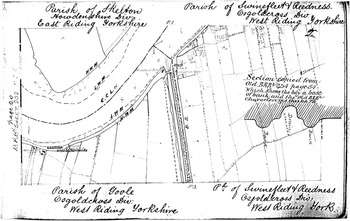
The OSBS was a painstaking operation in all its stages. Perhaps the most significant aspect to emphasize was that of public consultation which served to legitimize the process in the localities. This covered all stages from ascertaining the precise boundary alignments, through recording them on draft maps for public display and comment, to publication of topographic maps that made the spatial basis for established and reformed local politics graphically evident to all. First, the position of parish and other boundaries was marked in Boundary Remark Books in which the detailed alignment of the boundary was plotted with assistance from recognized parish officials and bearing their signatures in their capacity as meresmen.Footnote 59 The books consisted of strip maps, covering the full length of the boundary and showing its minute relationship to ground detail, such as whether the boundary follows the center or side of a stream, the face of a fence, or center of a ditch (see Fig. 1).Footnote 60
Boundary Remark Book, dated 1888, showing boundary determination in the Goole area, Yorkshire. Reference: OS 26/11810. By permission of The National Archives of the United Kingdom.

The detailed investigation of boundary alignment was accompanied by verification of name, status, and nomenclature of the administrative units in Parish Name Books.Footnote 61 Printed standard questionnaires were sent to parish overseers. For Appleshaw in Hampshire, it is recorded that the parish was not divided for the assessment and collection of rates.Footnote 62 Many other standard questions follow, such as whether constables are appointed, and if so whether for constituent divisions or hamlets, if these exist.Footnote 63 This laborious collection of detailed topographic and administrative information went somewhat beyond what the 1841 act demanded. Arguably, in collecting such data, the Ordnance Survey was aiming to establish itself as the ultimate repository of topographic data on administrative units.
After the initial survey of boundaries and nomenclature, the public was invited to comment on the maps displayed in Journals of Inspection.Footnote 64 These documents used a pro forma that included the applicant’s name and residence, the townships or parishes inspected, details of any old maps and other documents referred to, remarks made or differences pointed out, and the results of investigations made by the Ordnance Survey. The exhibition of a group of parishes in west Kent was held at the Ordnance Survey office at Tunbridge on January 15, 16, and 17, 1867, and then the following week in London. Notice of this was printed in the Estates Gazette of January 15, 1867 and in other local and national papers.Footnote 65 By making the draft maps of boundaries available for public scrutiny, the Ordnance Survey was enabling a degree of democratic participation in the exercise, while also ensuring that the boundaries were thoroughly scrutinized against local knowledge and usage. The notice of the inspection was addressed to “landed proprietors, clergymen, agents of estates, parish overseers . . . and all others interested in having the boundaries . . . correctly ascertained and accurately laid down on the plans of the Ordnance Survey.”Footnote 66 Many entries are indeed by those with an interest in landed property. For Capel Parish in Kent, the parish boundary was examined by the Marquis of Camden’s agent and found to be correct.Footnote 67 However, it was not only the parish establishment and local élite who were involved. In establishing the boundaries at Haworth Township in Yorkshire, inquiries went deep into the community. Local sheepkeepers on the common, Joseph Clayton and James Fether, were consulted by the main informant, Joshua Sunderland, the gamekeeper, to show the boundaries “betwixt Stanbury and Wadsworth.”Footnote 68
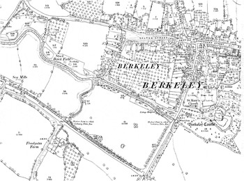
It was through the resulting published maps that the policy expressed in the 1841 act made its most obvious public impact. The depiction of boundaries on the largest-scale maps was done in a detail unprecedented in earlier maps. For most of the country, the mapping was made from the 1850s at the very large-scale of 1:2500, which permits the depiction of land parcels and related boundaries in great detail (see Fig. 2).Footnote 69 The process of mereing, “The Act of surveying, ascertaining and agreeing, on the ground, the true legal boundary line and describing the boundary in relation to the existing physical features by measurement as necessary” provides this precision, with mereings such as “4 Ft. RH,” that is, four feet from the root of the hedge were surveyed and recorded on the maps.Footnote 70 Thus the OSBS achieved a level of exactness and spatial intimacy that made the mapping a potentially intrusive record of the domains of local administrative units for all the public to see. More than a survey of boundaries, the Ordnance Survey published areas of administrative units on the largest-scale maps, such as indicating that Urswick Parish in Lancashire had an area of 3,904 acres, two rods, and three perches.Footnote 71 This areal data was indispensable to the Census and to government departments concerned with population density.
Ordnance Survey 1:2500 published map of Berkeley, Gloucestershire, showing boundary alignments and mereings. Gloucestershire Sheet 47/16, first edition, 1880–85. © Crown Copyright and Landmark Information Group Limited (2012). All rights reserved.

The Ordnance Survey’s published mapping was of clear utility in developing democracy in Britain in several related ways. Since no central record of parish and other public boundary alignments existed, the Ordnance Survey was based on local information, thus giving it legitimacy. It was available to all at reasonable prices rather than being kept secret or unpublished. Furthermore, once the existing boundaries of local administrative units were mapped, these could form the basis for planning a new system of local government to provide for local democracy and administration in the changing conditions of the nineteenth century.
As the OSBS proceeded, legislation was introduced to tidy many elements of traditional local administrative boundaries. After eliminating extraparochial places in 1857, the main provisions were the 1876 and 1882 Divided Parishes and Poor Law Amendment Acts, which enabled and then compelled merger of detached fragments of parishes with their neighbors.Footnote 72 Furthermore, in 1879, the Treasury ruled that the Ordnance Survey should no longer show mother (or ecclesiastical) parishes, as the often-now-different civil parish had become the only one of significance for local government purposes.Footnote 73 However, it took some time before the depiction of ancient units could be replaced by their modern successors: thus for much of the country, the OSBS stands as valuable historical record of a vanished administrative geography.
As well as reforming existing areas, many new kinds of local government units were created in the nineteenth century, such as the Poor Law union and registration and sanitary districts. These were central government creations rather than ancient survivals from a distant past. They were run by centralized bodies such as the Poor Law Commission, the General Register Office, and the Local Government Board and this may have meant more coordinated supervision of local officers under the Crown than previously. In recording boundaries of such new units, the Ordnance Survey was facilitating new kinds of central-local relations, but this did not ride roughshod over traditional basic units of local authority. There was no wholesale replacement of the basic administrative geography of the country. New administrative geographies emerged at a level higher than the parish, but they were composed from aggregations of that basic unit: after all, the union was a union of parishes and took on poor-law functions from that ancient unit.
Once an archive of boundary records had been amassed, it could be used as a basis for revision.Footnote 74 OSBS documents were annotated to record changes and new categories of document were created to systematize records of changes, such as Poor Law Union Files.Footnote 75 Such a file for Hollingbourn in Kent includes a pro forma for a “Divided Parish Inquiry” on which is summarized detached parts of parishes to be merged with neighbors.Footnote 76 The file includes correspondence with the Local Government Board, showing the working links between the two from notification of change by the board through to recording on archival boundary documents and on published maps. For Hermitage Parish in Dorset, attention is drawn to “an inconveniently situated part of this parish nearly surrounded by the parish of Minterne Magna.”Footnote 77 Copies of the divided parishes and poor-law legislation are held in the file for Lunesdale, stating specifically the changes to be made; in this case that detached portions of Farleton and Hornby townships be amalgamated with adjoining neighbors.Footnote 78 Once implemented, such changes were recorded on working documents, such as in Wiltshire, where a Boundary Remark Book is annotated prominently in red ink to indicate that “By L.G.B. Order 16,482, dated 14/12/83 this det[ached]. part of Highworth becomes amalgamated with Blunsdon St. Andrew on 24th March 1884.”Footnote 79
The Role of the Ordnance Survey in the Modernization of the State’s Knowledge Apparatus
From this examination of the processes of the OSBS, it is possible to assess how it should be characterized. Did it further the possibly centralizing policy ambitions of central government by creating a graphic inventory of local government areas that could then be analyzed with a view to rationalization? There are elements that might point to this. The Ordnance Survey could be represented as the cartographic arm of the executive, mapping the topography and boundaries of Britain in hitherto unprecedented detail and accuracy and imposing order on the landscape. This publicly funded work would not have been undertaken and funded were it not in the interests of central government. The Ordnance Survey was the first comprehensive and uniform national survey of Britain, drawn to a common specification and with high accuracy standards. As Delano-Smith and Kain observe, the Ordnance Survey can be said to constitute the first true national survey of Britain.Footnote 80
In anatomizing the spatial structure of local government units, the Ordnance Survey’s endeavors suited the ever-widening remit of central government in a number of ways. In the debate on the 1841 Ordnance Survey bill, utility to the legislature was advocated. Sir Hussey Vivian used the precedent of the survey of Ireland to note how useful it would be were this extended to Great Britain, where without such maps, “the greatest inconvenience had been experienced in carrying some of the recent acts of the legislature into effect.”Footnote 81 Vivian cited the Tithe Commutation and Poor Law Amendment Acts as examples where lack of reliable maps of administrative boundaries had been inconvenient and argued that a national survey would be productive of savings, an efficiency that would appeal to the government as sponsor.
As mentioned, a number of government departments were asking for maps of parish boundaries. Such mapping was of clear utility to democracy, allowing central government better to organize its dealings with emergent local government by having a clear cartographic overview of substate-level administrative areas. The work of boundary commissions charged with reforming electoral representation and ensuring that there was a better fit between parliamentary divisions and population would also be aided by national mapping of constituent administrative units. This utility seems to have been recognized in the employment in 1867, and again in 1884, of officers of the Ordnance Survey, as commissioners on the Boundary Commissions.Footnote 82 The task of the Census Office was facilitated by the calculation of accurate areas for parishes and other units: a by-product of an accurate survey of boundaries. Until the Ordnance Survey calculated acreages, census officials had “to resort to estimation and to admeasurements from County maps and other documents of a questionable character.”Footnote 83
That a clear policy commitment to public spending on mapping still obtained some years after the Ordnance Survey Act is evident from a letter of 1853 from Sir Charles Trevelyan at the Treasury to William Gladstone, then Chancellor of the Exchequer: “It is for the general advantage that this particular service should be performed for the community by the Government.”Footnote 84 Hence, in suggesting that the Ordnance Survey should be funded entirely at the public expense, the mapmaker’s work was being placed center-stage among the public services created, and sponsored, by central government for the benefit of all—a truly progressive nineteenth-century conception of public service. The boundary-mapping element of the survey was a vital part of this provision.
However, the case for government funding of mapping was contested, reflecting changes of ministries and exigencies of national finances. The Ordnance Survey Act of 1841 was introduced by the Melbourne administration, but later that summer it was superseded by that of Peel. This would seem to signify that central government lacked the political and financial will for the major funding that a nationalized mapping enterprise would require. This may have reflected ideological disputes on the role and size of government and the kinds of informational oversight that such a cartographic enterprise would facilitate. There was thus no long-term policy on the acquisition by the British state of topographic information on its internal boundaries, nor on large-scale public mapping per se.
The OSBS displayed elements of continuity with earlier mapping and surveying practice suggesting that the operation was evolutionary rather than representing a policy of radical reform by central government of local administrative areas. This was mirrored by the robustness of surviving ancient spatial structures of local administration. Over a century later, Lipman observed that the present local government system could be said to date from 1832, but a “striking feature . . . is that, with one exception of the poor law unions, the new units of administration were all based on existing areas.”Footnote 85 While a coordinated system of local government was created, it was made out of ancient units of local administration, with some anomalies such as detached areas and extraparochial areas tidied up. The Ordnance Survey was sensitive to this organic style of development. Its mode of operation is akin to the census in this regard, with John Rickman, its chief officer, observing in 1811 that the topographical arrangement of the data should not differ from established precedent and so it was “absolutely necessary to enter more minutely into the relative connection and identity of places than before.”Footnote 86
There was also continuity in the use of traditional administrative units as a basis for mapping. Even in the mid-nineteenth century, the Ordnance Survey used the parish as the basic unit of mapping for its large-scale maps (1:2500). Until the 1870s, maps were produced with areas beyond the parish edge left blank and were known as parish maps, accompanied by books of reference that itemized the acreages of plots of land numbered sequentially throughout the parish.Footnote 87 Continuity was also provided by the use of preexisting maps as evidence of boundary alignment.Footnote 88 The 1880 Boundary Remark Book for Great Glemham parish in Suffolk records that “the boundary in this Book transferred from the Tithe Plan of Great Glemham.”Footnote 89
These elements of continuity with earlier practice find their most significant expression in the use of local information, preference, and custom as the mainstays. The established order of private property, in particular, was not affected as the OSBS ascertained only public or administrative boundaries: the 1841 act is clear on this point. It was the landed property interest that was primarily called upon for the public inspection of boundaries. The standard notice, published also in local and national newspapers, stresses that “as the boundaries laid down on the Government Maps . . . may possibly become evidence respecting the Boundaries, and thus affect the right of Rating Lands . . . Therefore, Proprietors . . . are particularly requested to examine the Sketch maps . . . and to bring with them plans of their Estates for comparison.”Footnote 90
Thus the sensitive issue of private property was carefully nuanced by the Ordnance Survey. The only sense in which private property was investigated by the Ordnance Survey was over the issue of “property right,” where the alignment of public boundary is defined by a private property limit. This had the effect of asserting the primacy of property in determining public boundaries. A Boundary Remark Book for Yorkshire records that “the owners of hedges, banks, &c. in the parish of Haldenby generally claim 4 feet space into the adjoining lands, and they, the owners, can appropriate this space to any purpose they choose subject to all existing rights.”Footnote 91 Similarly, local custom was observed in the parish of Penrith in Cumberland, where the meresman Robert Nicholson affirms “that in all cases of measurement for purchases of land (that I have seen) the ditch has been included with the fence.”Footnote 92 In some cases, the Ordnance Survey even delayed the close of survey to allow time for a landowner’s interest to be protected. In determining the boundary of Anderton Township in Lancashire, the owners of the Anderton Hall estate thank the Ordnance Survey for “courtesy in postponing the close of the survey in order to give us an opportunity of reconsidering our client’s interests.”Footnote 93 These cases reveal the privileging of private property as evidence for public boundaries.
This sensitivity toward the totem of private property explains why the Ordnance Survey did not constitute a national cadaster or property map. This mapping of property boundaries was only undertaken by the Land Registry, and this only on a piecemeal basis, as registration was not compulsory until 1897, after our period. It was not retrospective and so property that stayed in the same ownership remained unrecorded.Footnote 94 The voluntary system of land registration from the establishment of a Land Registry in 1862 is in keeping with contemporary notions of liberty, which were hostile to intrusions into the enjoyment of property as a private concern. As Beech notes, relations between the Ordnance Survey and Land Registry were strained and there was little cooperation; not until 1888 did the Land Registry call in the Ordnance Survey to help with mapping for registration purposes.Footnote 95
An evaluation of the extent to which the OSBS was possibly implicated in a policy of strengthening the knowledge apparatus of central government would not be complete without a consideration of the role of the mapmaker itself as intermediary. The Ordnance Survey had justifiable technical requirements in boundary mapping. However, I argue here that the Ordnance Survey had a more ambitious agenda than simply to act as the disinterested provider of technical services to central government. The aim, I suggest, was to make the organization seem indispensable to national well-being through skillful self-promotion using the mechanism of annual reports and submissions to Royal Commissions. The comprehensive national survey of Britain’s administrative geography was a key part of this.
Paramount in the minds of Directors General of the Ordnance Survey was maintaining the high reputation of their maps. Great stress is laid in policy documents on the production of a uniform national survey. As has been suggested, this ambience, which the Ordnance Survey was keen to promote, was achieved without imposing similar uniformity on the administrative landscape of the country. Although a common cartographic specification was used to record the traditional boundaries and administrative names, they were recorded in all their perplexing oddness and diversity.
Utility to central government and the public alike is stressed in the first annual report of the Ordnance Survey in 1857.Footnote 96 The value of maps supplied to public departments is recorded, as are sales to the general public. Use of economical production methods such as anastatic printing ensure that “the public now have the plans at an extremely cheap rate . . . and it must be observed that the Government has thus conferred a great benefit on the community at large, and made the survey subservient to every practical purpose connected with property.”Footnote 97 A pitch is made for the utility of this mapping for a range of civilian purposes, perhaps relatively new to the thinking of a formerly military cartographer, such as transfer and valuation of property, “and many other important measures for which an accurate detailed survey is the necessary basis.”Footnote 98 All this needed a record of administrative boundaries overlain on the topographic detail. James was politically skillful: he was attempting to justify a sustained and increased financial commitment for public spending from a Treasury that had a visceral feeling against such public works, and especially the funding they required. He proactively promoted the utility of his maps for an ever-widening range of uses to make them still more indispensable as part of the knowledge apparatus of the state.
The technical requirements of the Ordnance Survey led it in some places to attempt to influence the timing of local government boundary reform. In a letter to the Local Government Board, Major Owen Jones of the Ordnance Survey Boundary Office sends a map of counties where the Ordnance Survey was ascertaining the boundaries of parishes and argues: “It would of course greatly facilitate our work if any changes in parish boundaries by the Local Government Board under the Divided Parishes Act 1876 could be made previous to the present boundaries being perambulated by our men or inserted on our plans.”Footnote 99 Was the speed of implementation of central government policy affected by the mapmaker’s pressure?
The Ordnance Survey went further than merely trying to affect the pace of implementation of legislation, perhaps raising questions about the legitimate scope of a government cartographer. In an overt attempt to sway central government policy on the spatial composition of the emerging local government system, Henry James, director general of the Ordnance Survey, writes in 1871 to the Local Government Board that “the present extreme confusion in all the civil divisions of the country . . . was such as to demand the attention of Government and Parliament.”Footnote 100 Ordnance Survey maps were appended for polemical effect to highlight examples of parishes and townships existing in numerous intermixed and detached portions, demonstrating the spatial irrationalities. James’s initiative seems to have had effect. A reply from the Local Government Board in 1873 states that “the President [of the Board] has given notice of his intention to move for a select committee of the House of Commons to enquire . . . whether existing boundaries . . . may be so altered and adjusted so as to prevent the inconvenience in matters of social administration and taxation.”Footnote 101 Such a committee was established and had the remit of reporting on whether boundaries should be adjusted to make local administration and taxation more convenient.Footnote 102 Arguably, the legislative reforms of local government areas followed in the wake of this report.
Conclusion
The OSBS cannot be construed simply as an imposition by central government upon the localities to enhance its knowledge apparatus, mediated by the state mapmaker. This “knowledge” was in large part derived from the localities and so its status in monopolizing power in the hands of central government has to be qualified. There is no doubt that the Ordnance Survey’s large-scale mapping of England and Wales, including a detailed perambulation of boundaries, served the interests of central government squarely, and was potentially a tool of standardization and imposition. An external committee of inquiry into the Ordnance Survey in 1871 resolved that the importance and specialized nature of the boundary work made it desirable that the separate Boundary Department in London is retained.Footnote 103 The OSBS was an aid and even a stimulant of local government reform, and though it was not its cause, it was probably necessary to have the backdrop of the maps for planning changes. It has been shown that the OSBS was of great utility to democracy, both nationally and locally and in a number of ways. This has a broader significance in indicating that mapping can have different potentialities and outcomes in different institutional and constitutional contexts.
Richard Oliver contends that the Ordnance Survey became central to national mapmaking in the course of the nineteenth century because it delivered mapping that met most national needs. For him, the Ordnance Survey’s activities were a significant step in extending central government activity.Footnote 104 The OSBS needs to be seen against the backdrop of the time of considerable change and controversy in which it played a part. Seymour argues that nineteenth-century industrialization and social change witnessed a clash of old and new interests and that “to some the large-scale survey represented another extension of state intrusion, and to others an unwarranted incursion into the field of private enterprise.”Footnote 105
The Ordnance Survey had a difficult task in balancing central government requirements for reform and efficiency with the possibly conflicting long-cherished English notions of local self-government, however illusory these may have been.Footnote 106 This mentality can perhaps be understood from the 1873 Select Committee report on the boundaries of parishes, in which the registrar general refers to “the absence of symmetry and system which is a peculiar in our national organization . . . that makes us hesitate to [have] . . . centralized administrative organization.”Footnote 107 While the Ordnance Survey was principally implicated in the activities of central government, of which it was an extension, it took account of the sensitivities of localities that it was charged with anatomizing. Long-standing usages, knowledge, and cartographic traditions were drawn upon, thus avoiding the coarse imposition of an amorphous and alien territorial blueprint for the local state, ab initio, as central government extended its gaze into the localities in the course of the nineteenth century.