

Introduction
A bad history, reified within political systems, has directly impinged on the prospects of peace between India and China, and without academic overreach it can be argued that there is no clearer understanding today of the minutiae of claims relating to the boundary between the countries than there was in 1962 when the two countries went to war. The efforts to define and delimit a linear boundary between India and China in the late-nineteenth and early-twentieth century can be seen in consonance with the principle of “exclusive territorial jurisdiction”Footnote 1 that had developed during the seventeenth and eighteenth centuries (moving away from the overlapping layers of jurisdiction in medieval times) in favour of linear territorial delimitations. The latter lent legal impermeability to the state in relation to foreign powers, as well as exclusive jurisdiction and supremacy over its territory and inhabitants.Footnote 2 The process of boundary-making between British India and China, then, was very much the exemplar and product of the political practice of the times.
The India–China boundary is usually trifurcated intro three segments – the Western Sector (covering proximate areas of the Ladakh region of Jammu and Kashmir with Tibet, and also the segment which technically is now Pakistan-occupied Kashmir, with Sinkiang); the Middle sector (proximate areas of Uttarakhand and Himachal Pradesh with Tibet); and the Eastern sector (the proximate areas of Arunachal Pradesh with Tibet). While previous studies (chiefly, creditable accounts of scholars such as Parshotam Mehra, A.G. Noorani, Alistair Lamb, Karunakar Gupta, Neville Maxwell, among others) have examined the claims and counterclaims on the boundary by both countries to varying degrees, this article brings into focus hitherto unused archival material and diplomatic correspondence from the boundary-making exercises in the Western and Eastern sector.Footnote 3 It also introduces cartographic evidences from Chinese sources and expeditionary travellers.
The theoretical point of departure is the constructivist paradigmatic optic it employs in order to discern how creation of knowledge, beliefs and norms in each country's decision-making process evolved over time to alter the meaning and construction of the material reality of the boundary.Footnote 4 Such perception relating to the boundary, the article suggests, does not overlap with the actual historical evidence emerging from either side on the same issue but which each country nonetheless tends to reproduce in pursuance of a socially constructed reality. This is best exemplified in claims of a ‘traditional and customary’ boundary. The constructivist dependent variable, loosely defined, would be the ‘preferred boundary line’ by each country over time. The independent variables identified here comprise ideational and material shifts in the historical preferences revealed by India and China (revealed as such through diplomatic correspondence and cartographic evidence). The article intends to answer two key research questions – namely:
1. Are there discernible internal inconsistencies in the representation of what each country claims as its ‘traditional/customary’ boundary?
2. Were the boundary-making processes [definition and eventual delimitation] in the Western and Eastern sectors delinked from each other?
Evolution of Boundaries: the Western sector
India's claim in the Western sector evolved out of Britain's attempts to define and delimit a boundary with China. Here, the boundary falls into three main sections – the stretch from Wakhan (Afghanistan edge) to the Karakoram pass, namely between Kashmir and Sinkiang, followed by the stretch from the Karakoram pass to the Lanak La that comprises the area between the Karakoram and Kunlun mountain ranges (an alignment which covers the barren wastes of Aksai Chin and Lingzi Tang plains), and the third section of the boundary, from the Lanak La to Demchok (between Ladakh and Tibet).Footnote 5 The Indian position has been that the entire Ladakh area (including Aksai Chin) became a part of the Jammu and Kashmir State as a result of a treaty signed in 1842 on behalf of Maharaja Gulab Singh and the Lama Gurusahib of Lhasa, and the representative of the Emperor of China.Footnote 6 The British commissioned several surveys in the second half of the nineteenth century (having acquired Kashmir in 1846) to discern the limits of Kashmir, but the Chinese did not take part in these surveys. A clarification by the Chinese CommissionerFootnote 7 on 13 January 1847 notes:
I beg to observe that the borders of these territories have been sufficiently and distinctly fixed so that it would be best to adhere to this ancient arrangement, and it will prove far more convenient to abstain from any additional measure for fixing them.
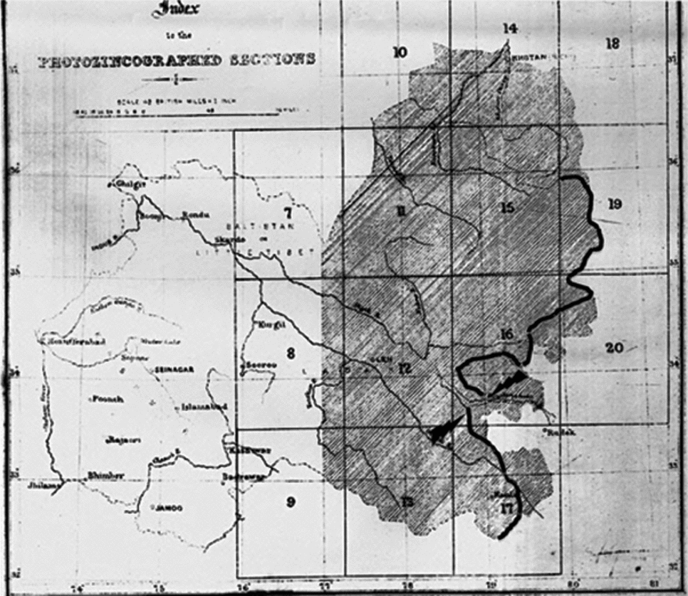
One of the earliest official delimitations of the northern frontiers of India appears in photozincographed sections of part of the survey of Kashmir, Ladak and Baltistan or Little Tibet showing the “Boundary of His Highness the Maharajah of Kashmir” (8 miles to 1 inch, Dehradoon, October 1868).
The need for defining and delimiting the boundaries of India are best understood in the context of the “Great Game”, which referred to the rivalry between Britain and Russia in Central Asia throughout the nineteenth century.Footnote 8 Growing fears of Russian proximity to India (creeping in from Central Asia to the trijunction of Afghanistan, India and China) meant that the “inhospitable lands to the north of the Vale of Kashmir” became the playground for this rivalry.Footnote 9 Until the mid-1870s, “the British were satisfied to leave direct jurisdiction over these northern marches in the weak hands of the Maharaja of Kashmir through his Waziri-Wazarat at Gilgit”.Footnote 10
This assessment of a threat from Russia had concrete basis, and Chinese Turkestan (present-day Xinjiang 新疆) was a case in point. It was under the Manchu emperor Chien Lung (清乾隆皇帝) that the outlying Turkestan was annexed by China in 1759.Footnote 11 In Kashgaria (also known as ‘Little Bokhara’) (presently the region comprising the southern part of Xinjiang), disorders were stirred up from 1820 to 1860 and a series of Muslim insurrections in I862 (known as the Dungan rebellion 同治陕甘回变) emerged farther east in Turkestan.Footnote 12 The warring factions were subdued by Mahomed Yakub (subsequently called Yakub Beg), who was able to establish himself as ruler of all the western tip of Chinese Turkestan.Footnote 13 Yakub Beg succeeded in seizing almost the entire strip of territory beyond the mountains of Kashgar, owing to the weakness of the natives, the Khokand Khans.Footnote 14 As a result of these disturbances, the Russians edged closer and occupied the district of Ili in 1871, and secured more advantages thereafter in 1872 from the native rulers.Footnote 15
Yakub Beg interrupted Emperor Chien Lung's rule in Turkestan since 1759 for fifteen years, from 1863 until 1877.Footnote 16 Subsequently, when the Chinese re-established their rule in Kashgaria in 1878, they adopted Yakub Beg's frontier line.Footnote 17 Following the Chinese return, Russia obtained the area near to the Great Karakul Lake by the treaty of St Petersburg (1881) and strengthened her position by the extension of communications and rail and road infrastructure in the area.Footnote 18 The British confidential assessment was that “in case of war between Soviet Russia and China, the former would occupy at least the portion of Sinkiang to the north of the Tian Shan (天山) mountains and probably also Kashgar and Yarkand”,Footnote 19 bringing them proximate to British territory.
The alternative was either to move the British frontier northwards of the Karakoram range to include places such as Shahidulla (ruled out by Captain Edward Francis YounghusbandFootnote 20 as being “offensive to the Chinese”) or to make China assume “efficient control” over territories such as Raskam to keep the Russians at a distance.Footnote 21 The Russian threat was perceived in both the Foreign Office and the India Office (in London). The policy drift was that were Russia to occupy Kashgaria, a wedge of territories between Kunlun (昆仑) and Karakoram could be arranged as a ‘neutral state’,Footnote 22 and for that to happen Britain needed some locus standi by way of a treaty arrangement with China to avoid a coterminous boundary with Russia in the event of the latter turning successor to China in ruling Xinjiang.
It is also useful to note that the confidential Gazetteer of Kashmir and Ladak (together with Routes in the territories of the Maharaja of Jamú and Kashmir), compiled under the direction of the Quarter Master General in India in the Intelligence Branch (1890), while discussing the eastern boundary of Ladak notes that “from the Kuenlun mountains (昆仑山脉) southwards to the head of the Changchenmo valley, the boundary between Ladak and Tibet is quite doubtful”.Footnote 23 Reference is also made to the “neighbourhood of the Pangong lake where there have been boundary disputes”.Footnote 24 The northern boundary of Kashmir and Ladak is described as extending from Nagar (on the western extremity) to the frontier of Tibet on the east and, more importantly, that “it has not yet been definitely determined”.Footnote 25 The Gazetteer also notes that: “From the Karakoram pass eastwards to past the meridian of 80 there has been no authoritative demarcation, and as the country is quite uninhabited for more than 160 miles in every direction, the actual state of occupation is no guide”.Footnote 26 Although the names ‘Lingzithang’ plain and Aksai Chin are used interchangeably in this Gazetteer, the detailed description for the location notes that the “Lokhzung range is fixed as its northern boundary”.Footnote 27
‘Great game’ strategising resulted in a few solutions being prescribed. A. G. Noorani describes the “Forward school” which advocated the Kunlun range as the boundary (Ardagh line of 1897),Footnote 28 as implying that the areas hitherto designated to become neutral states would be included within India, while the other school was exemplified by the Macartney–MacDonald line of 1899, which followed the Karakoram alignment for the northern frontier. The latter excluded Aksai Chin from India but retained a part (the Lingzi Tang plains) in India, thus overlapping with the 1890 Gazetteer of Kashmir and Ladak’s description of the Lingzi Tang plains as bounded by the Lokhzung or Lak Tsung Range.
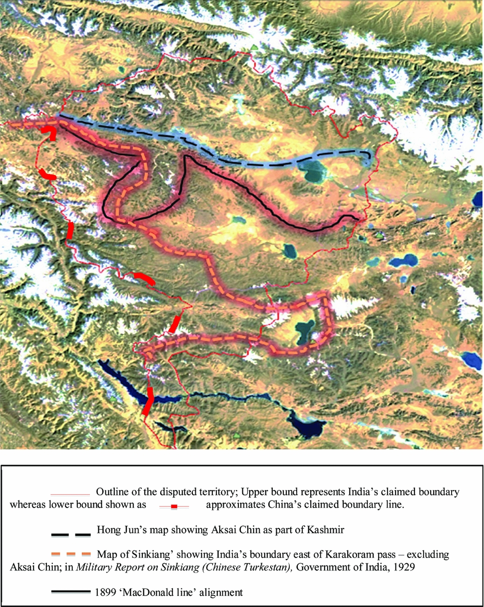
Eventually, Sir Claude MacDonald, British minister in Peking, addressed a formal note to the Tsungli Yamen (Chinese Foreign office 总理衙门) on 14 March 1899 which remains the only official communication from the British government to the Chinese government (without any accompanying map), defining the limits of India for purposes of a boundary with China in the western sector.Footnote 29 The basis of the 1899 line (see Figure 2) was geographical features and a reference to Sir George Macartney's (Special Assistant for Chinese Affairs, and subsequently consul-general in Chinese Turkestan) input relating to a map shared by Hong Jun (洪钧) (erroneously cited as Huang Tachin),Footnote 30 showing Aksai Chin as part of Kashmir. Thus, also the name, “Macartney-MacDonald” line.
Published in the Office of the Superintendent, Great Trignometrical Survey of India, India Office Records; Note in particular: (a) partition of the Pangong Lake in inset 16; (b) boundary rounding off south-west from Hanle in inset 17, implying that Demchok is excluded from India. The large-scale version of each of the inset maps notes that they are compiled from surveys and rough sketches (italicised for emphasis) by W. H. Johnson, Civil Assistant, GT Survey. Bold insert added for emphasis in maps throughout this article.

Conceptions of the boundary line for India's western sector.

To complicate matters, further modifications of these lines in the western sector were effected by the British government (in 1905 and 1912, chiefly coinciding with the collapse of the Qing dynasty 清朝 in 1911). But none of these changes were communicated to China. The assumption in reverting to the forward school, as opposed to the 1899 line communicated to the Chinese, is that as the Chinese never responded to that line, the British government were not bound by it. Interestingly, it was Foreign Secretary McMahon himself who demanded in 1912 that India go back to the 1897 Ardagh boundary, i.e. the Kunlun (昆仑山) mountains alignment, which, he noted, “exactly suits our political interests”.Footnote 31 A later note of the Viceroy (dated 12 September 1917, labelled “Foreign Secret”) revisits the status quo of areas between the Karakoram and Kunlun ranges:
in Chinese hands this claim is harmless, but transferred to Russia it will prove embarrassing. . .demand as a preliminary to negotiations, recognition of a boundary line which will place Taghdumbash, Raskam, Shahidulla, and Aksai Chin outside Russian and within our territory. . .A line similar to that proposed by Sir John Ardagh in 1897 vide our Foreign dispatch No 170, Secret/Frontier dated 23 December 1897 will obtain this effort.Footnote 32
However, this was not the last on the boundary in the Western sector. Scholars such as Alistair Lamb and Noorani discuss the redrawing of India's boundaries in the north in 1927 where the government of India resolved to abandon most claims north of the Karakoram watershed using a variant of the Macartney–MacDonald line excluding a greater portion of Aksai Chin.Footnote 33 Noorani's work does not reproduce that realignment of the Macartney–MacDonald line, although he does marshal the work of others such as H. A. F. Rumbold (official in the India office) who is cited to the effect that in 1929 such a map of India's northern frontier excluding Aksai Chin (roughly along the crest of the Karakoram range) was attached to Volume 1 of the Report of the Simon Commission that came out in 1930.Footnote 34 With regard to Aksai Chin, per se, there was some clarity by the late nineteenth century that there are two distinct localities named Aksai Chin (one partly in the Lingzi Tang plains and the other to the east of the plains; the latter, as A. Stapleton, Deputy Secretary, had noted on 7 January 1897, has “never been included within our boundaries”.)Footnote 35
In all likelihood, the alignment that Noorani and others refer to can be found in an official map of the government of India in the Military Report on Sinkiang (Chinese Turkestan), 1929 (see Figure 2). The Map of Sinkiang which accompanied this military report shows Aksai Chin (located in Sinkiang) as also partly based in Tibet; and the trijunction of Kashmir–Xinjiang–Tibet boundary lying west of the 79° E longitude, even though Indian territory is shown to extend until west of the 80° E longitude at its proximity with Tibet further south. This map was based on multiple sources including Survey of India sheets, with inputs from surveyors such as Sir Aurel Stein, Major Mason, Russian staff maps, among others. This alignment, which depicted the boundary east of Karakoram Pass, was not seen in Independent India maps, where the shift from “boundary undefined” to rigid boundaries under an overall Ardagh–Johnson alignment has been adopted since 1954.
Examination of Key Cartographic Evidences (China's Representation of the Boundary in the Western Sector)
China's reaction to the status of these boundary lines, has been that:
British imperialism, seeking a short-cut for invading the heart of Sinkiang, laid covetous eyes on the relatively flat Aksai Chin in the eighteen sixties and dispatched military intelligence agents to infiltrate into the area for unlawful surveys. In compliance with the will of British imperialism, these agents worked out an assortment of boundary lines for truncating Sinkiang. The British Government did try at one time to alter according to its own wishes the traditional customary line in the western sector of the Sino- Indian border, but was promptly rebuffed by the Chinese GovernmentFootnote 36 [italicised for emphasis].
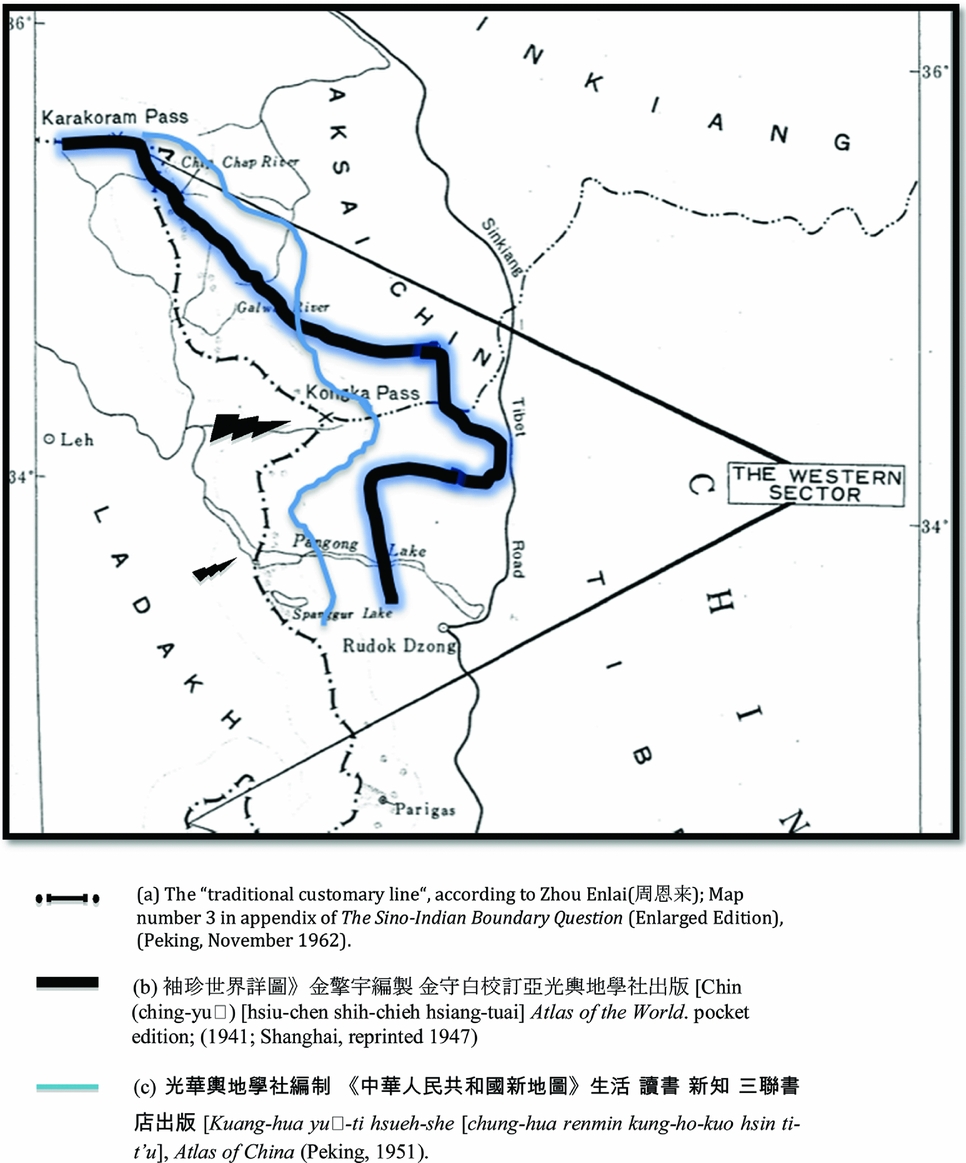
China's claim of what it perceives as its “traditional customary” boundary vis-à-vis India is depicted in Figure 3 (index key a), which was the map appended by Zhou Enlai (周恩来), first Premier of the People's Republic of China and Nehru's counterpart, in his official letter to Asian and African leaders (dated 15 November 1962).Footnote 37 Three features in Zhou's map demand attention, namely:
1. The India-China boundary is fixed by a line which dips south sharply from the Karakoram Pass to the east of the 78° E longitude,
2. The tri-junction of Kashmir, Xinjiang and Tibet is shown at Kongka Pass and
3. The boundary cuts Pangong Lake at its widest stretch.
Shifting conceptions of the boundary line for China.

However, Zhou's claim of the “traditional customary line” is not substantiated by the presentation of the boundary in this sector in other official maps issued by China. For instance, as shown in Figure 3 (index key b), the Atlas of the World (pocket edition; 1941; reprinted 1947), clarifies in its editorial note (dated 1935) that north of India is Xifu Kela-kunlun Shan (西附克拉昆仑山) [not the Karakoram range or Kelahulu, loosely in pinyin] indicating, in all likelihood, the spur of the Kunlun running southwards. This map was approved by the Ministry of Internal Affairs/Security (Nei Zheng Bu 内政部) under, what was then, the Republic of China.Footnote 38
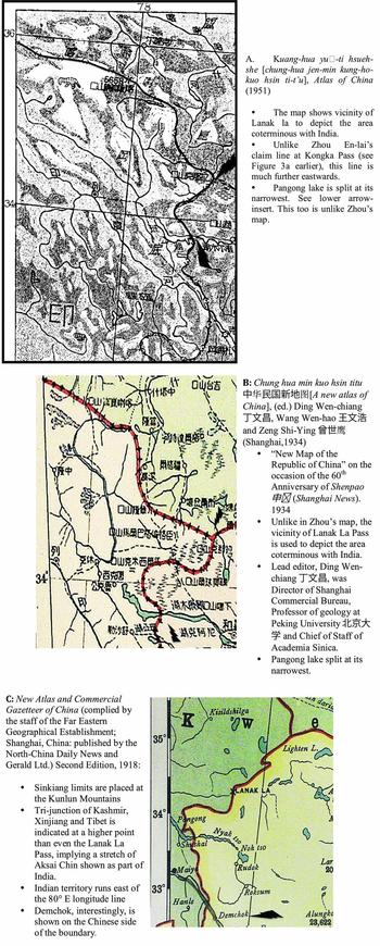
Likewise, the 1951 Atlas of China was one of the earliest maps published by the PRC (see Figure 3 index key c). The agency accrediting the maps was Zhongguo Tushu Faxing Gongsi (中国图书发行公司; a government–approved office, the same as that which approved the 1947 map mentioned above). What is interesting in this map (original reproduced in Figure 4 A for detail) is that the vicinity of Lanak la is used to depict the area coterminous with India (unlike Zhou En-lai's claim line at Kongka Pass which lies much further westwards). Pangong lake is split at its narrowest between India and China. Interestingly, the editorial note in this map cautions that “at some places the editors were not sure of drawing the exact line and whether to do that or not was also problematic” (the editors, curiously, sought time from the readers).
Official Chinese maps depicting the Indian boundary (Western sector) (Boundary/inserts highlighted in bold by author).

While scholars such as Parshotam Mehra, A.G. Noorani and Alistair Lamb have noted the Chinese position on the MacDonald line in terms of an absence of official response to the 1899 British proposal, there is evidence on China's official presentation of an alignment similar to the MacDonald line alignment, as well as the lack of a consistent “traditional customary line” that Zhou En-lai claimed China has for this sector (see Figure 4).
With the insight of cartographic evidence from Chinese sources (and not limited to Figure 4 A, B, C), it may be deduced that the Chinese “traditional customary line” was not an unambiguous fixed one, since clearly the line was mutable from the early twentieth century onwards. The contention here is not to stress the legal validity of claims on territory established through cartographic evidence.Footnote 39 This article suggests from eclectic archival sources the phenomenon of mutability of boundaries as represented in official cartographic presentations. The stress is on the observation that the vicinity of Lanak La (which was the extremity of India in the last officially communicated boundary line to China, i.e. the Macartney–MacDonald Line) has been implemented in several official maps published by China.
Evolution of the Boundary Line in the Eastern Sector
As with the Western frontier (discussed earlier), trouble was emerging in the second half of the nineteenth century on China's southern front. In 1888, a series of Tibetan aggressions on the Sikkim border resulted in the intervention of the Indian government.Footnote 40 In consequence, at the request of China, Britain consented to the conclusion of the Anglo-Chinese Agreement of 1890 that aimed at regulation of commercial and frontier questions – on the explicit understanding that China would enforce the terms of the treaty in Tibet.Footnote 41 To settle the question of border pillars and demarcation on the Sikkim–Tibet frontier, Tibetans (Sonam Topkye and Tenzing Wangpo) and Chinese (Major Li Teng Shan 李腾山, then commanding Ching-His district) were initially deputed (the latter being replaced by Major Tu Hsi-hsun 涂思隼 in 1895).Footnote 42 It is interesting to note the explicit communication that the “three parties” (India, China and Tibet) could agree upon a date for starting together on the work of demarcation.Footnote 43 Owing to several difficulties in realising gains either in commercial or frontier matters, a conference was convened on 17 November 1898 under J. C. White, Political Officer in Sikkim, in the presence of Li Yu Sen (李宇森) Special Deputy for Frontier Affairs, Dungen Tenzing Wangpo, the M. Depon and the Chanzod of Tashi Lempo.Footnote 44 White's conclusion was:
ii. The Tibetans know the position of the boundary as laid down in the Convention, but assert that the Amban had no right to place it there. . .iii. The Tibetan officers are unable to give any answer as to trade concessions. . .v. That the Chinese authority has of late years much declined at Lhasa, and that now they have practically no authority over the Tibetans, and that the Tibetans are asserting themselves and wish to throw off Chinese yoke. The Chinese acknowledge they have no authority, and the Tibetans say the Chinese have no right to treat for them. [italicised for emphasis].Footnote 45
Diplomatic correspondence from the time reveals a stalemate as far as demarcation of the boundary and commercial intercourse was concerned owing to deliberate obstruction of the Tibetan Government and its representatives on the one hand, and to the inertia of the Chinese on the other. . . all trade with India has been stopped by the Tibetan Government. . . Perhaps, however, the most conspicuous proof of the hostility of the Tibetan Government and of their contemptuous disregard for the usages of civilisation has been the arrest of two British subjects from Lachung at Shigatse, whence they have been deported to Lhasa, and, it is credibly asserted, have been tortured and killed. . .Footnote 46
The British response was in the form of expeditionary-style force under Francis Younghusband to “initiate a change in Tibetan behaviour”Footnote 47 in 1903–1904 (and also to check the fears of growing Russian influence in Tibet).Footnote 48 This was, in plain terms, an attack on Tibet that forced onto the Tibetans direct engagement with the British through the Anglo-Tibetan Treaty of 1904. This also ended with the occupation of Chumbi valley until the Tibetans paid a punitive indemnity. Article nineFootnote 49 in the 1904 Anglo-Tibetan Treaty specifically stated that “The Government of Tibet engages that, without the previous consent of the British Government –
a. No portion of Tibetan territory shall be ceded, sold, leased, mortgaged or otherwise given for occupation, to any foreign Power;
b. No such power shall be permitted to intervene in Tibetan affairs;
c. No representatives of agents of any foreign Power shall be admitted to Tibet;
d. No concessions for railways, roads, telegraphs, mining or other rights, shall be granted to any foreign Power or the subject of any foreign Power. In the event of consent to such concessions being granted, similar or equivalent concessions shall be granted to the British Government;
e. No Tibetan revenues, whether in kind or cash, shall be pledged or assigned to any Foreign Power, or the subject of any foreign Power”
(italicised for emphasis)
The Diaries of Sir Ernest Satow, British Envoy in Peking (1900–06), Vol.2 (1904–06) records in fair detail the unease of the Chinese towards this article. This lead to negotiations over two years on an adhesion agreement with China in order to confirm China's rights in Tibet. Referring to Tong Shoa-yi (唐绍仪), Vice-President of the Board of Foreign Affairs, Ernest Satow records how the former demanded that “China must pay the Tibetan indemnity, and that the principal object of his mission to Calcutta was art. 9 of the Convention”.Footnote 50 The ‘Calcutta talks’ were the first instance wherein China's locus standi vis-à-vis Tibet was contested as between ‘suzerainty’ (as the British desired) and ‘sovereignty’ (as China insisted).Footnote 51 Eventually, Satow notes, “she herself preferred to omit it (‘suzerainty’), we I thought need not object. I wld. teleg. as he proposed”,Footnote 52 referring to the 1906 adhesion agreement (which eventually omitted out the word ‘suzerainty’). Satow suspected that China's unwillingness to sign onto ‘suzerainty’ descriptions vis-à-vis Tibet, and offering to pay the punitive indemnity imposed on Tibet by Britain, did possibly entail “a wider plan which aimed to claim outright sovereignty over Tibet”.Footnote 53
The British government was having a tough time in the three trade marts in Tibet (at Yatung, Gyantse and Gartok), where they wanted trade to be opened up (the chief gain from the Younghusband expedition). The Tibetan unwillingness to transact with the British at that time (either on frontier affairs or trade concessions) and the Chinese dissatisfaction with any British communication with Tibet directly was duly recorded.Footnote 54 By 1908, unlike previous instances of Britain's direct diplomatic intercourse with Tibet, the signing of the Tibetan trade regulations on 20 April 1908 was executed at Calcutta by E.C. Wilton, CMG, the British commissioner, Chang Yin-tang, Chinese commissioner and Wangchuk Gyalpo, the Tsarong Shape (Tibetan delegate). Around the same time, the armed offensive of Chao Erh-feng (赵尔丰) [Imperial Commissioner for the new territory on the Frontier of Tibet (and subsequently Amban in Tibet)] to consolidate effective authority in Tibet, signalled to the British government that China was in the process of converting “her loose traditional suzerainty into a rigorous and effective sovereignty” in Tibet.Footnote 55 With China at its weakest in 1911, Tibet attempted revolt with the mutiny of the Chinese garrison at Lhasa and an appeal to British mediation – which was refused by the British.Footnote 56
The context of the ‘Great Game’ between Britain and Russia was still relevant. By the turn of the century, this rivalry had resulted in “rapid forward movements towards Tibet by both countries”, with the British suspecting “collusion between the Dalai Lama and the Russian Tsar”.Footnote 57 To the British, the conclusion of the URGA protocol and the Russo-Mongolian Agreement of 1912, The Mongol–Tibet treaty of January 1913, the Russo-Chinese agreement in regard to Mongolia (5 November 1913) had changed the status quo in Tibet (much in line with the recognition of autonomy that Tibet wanted to secure).Footnote 58 The British response was to organise a treaty that would settle once and for all the issue of Tibet's status under international law, and thus the idea for the Simla Conference was born.Footnote 59 A confidential note from the India office to the Foreign office reveals that what ultimately took the form of the ‘Simla Conference’ was convened at the request of Tibet.Footnote 60
In terms of diplomatic precedence, whether it concerned demarcation of the Sikkim–Tibet boundary or the question of opening of trade marts in Tibet, clearly Britain was aware (and practised) the need for obtaining Chinese concurrence/adhesion agreements in matters pertaining to Tibet. This was clear from the Younghusband expedition to Lhasa in 1904 (and the need for a confirmation convention between Britain and China subsequently in 1906), and the 1908 Trade regulations. However, the British were dealing with Tibet differently now. With the Republican government in place in China (following collapse of the Qing dynasty), on 5 June 1913 Yuan Shihkai (袁世凯) accepted the tripartite conference by notifying the appointment of Ivan Chen (Chen Yi-fan 陈贻范; controller of foreign affairs based at Shanghai) as Chinese plenipotentiary on 6 June 1913 (on 14 June Henry McMahon was appointed and Longchen Shatra (prime minister of Tibet) was nominated by the Dalai Lama (达赖喇嘛)).Footnote 61 McMahon interestingly records that acceptance by China for the tripartite conference in India was obtained by the “threat of a dual settlement between England and Tibet independently”.Footnote 62
The ‘Simla Conference’ was thus convened from November 1913 (after the plenipotentiaries assembled on 13 October), and from McMahon's early memos on 6 November 1913 on the same, it is evident that a map referring to the frontiers of Tibet as claimed by Chinese and Tibetan plenipotentiaries (drawn by the parties themselves) was circulated [it has claim lines in yellow by the Chinese; a green claim line by Tibet; blue and red claim lines for inner and outer Tibet respectively] at the conference.Footnote 63 This was a small-scale modified Royal Geographical Society map of 1906.Footnote 64 McMahon proposed the division of Tibet into inner and outer zones, where “the outer zone, which included Lhasa, was to be autonomous: the inner zone, though remaining an integral portion of Tibet, was to be subject to some degree of Chinese control” – a proposal that, according to him, was approved by His Majesty's Government.Footnote 65 Interestingly, the British strategy to block Russian influence at the Kunlun mountains by keeping Aksai Chin in TibetFootnote 66 also found its way into the map, where Lingzi Tang is marked as lying south of the Tibet zonal boundary.
China was not a reluctant participant in the proceedings of the conference, nor was it averse to discussion on Tibet's frontiers. The communication from the Viceroy [marked Foreign/Secret/Tibet conference; P4798 No. 54] on 24 November 1913 clarifies that the “Chinese plenipotentiary has informed McMahon that he has received a telegram from his government, authorizing him to join in discussion regarding territorial limits of Tibet, on condition that other clauses of Chinese statement of counter-claims will be discussed as soon as there is a prospect of reaching a settlement of the frontier question”. Following five months of negotiation the draft convention was placed upon the table on 11 March 1914, but which was rejected by the Chinese plenipotentiary under instructions from his government following which, by McMahon's own admission, China was threatened for the second time with the likelihood of Britain concluding an independent settlement with the Tibetans.Footnote 67 The draft was subsequently initialed by Lonchen Shatra and McMahon on 27 April 1914 and, according to McMahon, at the last moment, before the conclusion of the meeting, the Chinese plenipotentiary added his initials to the document.Footnote 68
Subsequently, the initials of the Chinese plenipotentiary were repudiated by China, which instead brought fresh proposals in regard to the map attached to the initialed convention, aimed at the recognition of a Chinese–Tibet frontier within 200 miles of Lhasa.Footnote 69 Not only were the initials repudiated by the Chinese government, the convention itself was amended by McMahon.Footnote 70 Normally, an amendment to any legal document adopted by three parties should reflect the subsequent alteration of the original consent of the parties, but, curiously, at the Simla Conference the three plenipotentiaries did not initial the amended convention. McMahon himself acknowledges that the original initialing of 27 April 1914 had “possibly become invalidated in consequence” due to the amendment effected.Footnote 71 When the amended draft was conveyed to Peking (along with the invitation to sign), McMahon indicates that Peking reopened the whole question, to which Britain threatened China a third time with “the alternative of co-operation with us or of seeing the conclusion of an independent agreement with Tibet”.Footnote 72 At the final meeting of the conference on 3 July 1914 – the Chinese plenipotentiary conveyed his inability to signature on a tripartite basis, and Britain concluded an independent agreement with Tibet. The play of events therefore points to a final Convention and Declaration – which did not have any initials of the Chinese plenipotentiary.
But this was not the only play of events. Even as threats to negotiate separately with Tibet were issued thrice by Britain to China, on 24 March 1914 itself notes were exchanged (along with two maps) and signed between the Tibetan plenipoteniary and Henry McMahon in Delhi (where the conference moved to in view of the winter in Simla) regarding the India–Tibet boundary between the Isu Razi Pass on the Salween–Irrawaddy divide on the east and Bhutan on the west. The map in two sheets (General Staff, India, North-East Frontier, Provisional Issue, scale 1 inch= 8 miles) bearing endorsements signed by the Tibetan plenipotentiary and McMahon – were not the same as the small-scale map circulated at the tripartite talks. This act of defining and demarcating the southern boundary of Tibet along with elaborate agreement on concessions relating to pilgrimage routes and the safeguard of Tibetan ownership in private estates on the British side of the frontier did not involve the Chinese. By McMahon's own admission in his memo, “the section of frontier in question although over 800 miles in length has hitherto been absolutely undefined”, and the Chinese were probably not aware of all the documents executed at the conference. The British threat to negotiate separately with Tibet (even as late as June 1914) was, it appears, a bogey, since an agreement had been signed on 24 March 1914, and clearly the ‘McMahon line’ had been established even before the tripartite convention involving China was initialled on 27 April 1914.
The process of arriving at the ‘McMahon line’ may be questionable, but the basis of the line vis-à-vis the southern limit of Tibet was not contested by China at any time, nor did it record any objection to the lines dividing Tibet and India – a process in which China participated for nine months. Translation of a telegram received from Wai-chiao Pu (外交部) (communicated by the Chinese Embassy, dated 29 June 1914) states that “differences in the Tibetan negotiations only arise from the boundary question; that Chiamdo (昌都) and Jyade (thirty-nine tribes) have always been within China's military operations, and the fact that China has recognised them to be within Inner Tibet already constitutes a very great concession”.Footnote 73 The reference to the thirty-nine tribes/Jyade is the area proximate to the Indian frontier, but that stretch of territory lies distant from present-day Arunachal Pradesh.Footnote 74
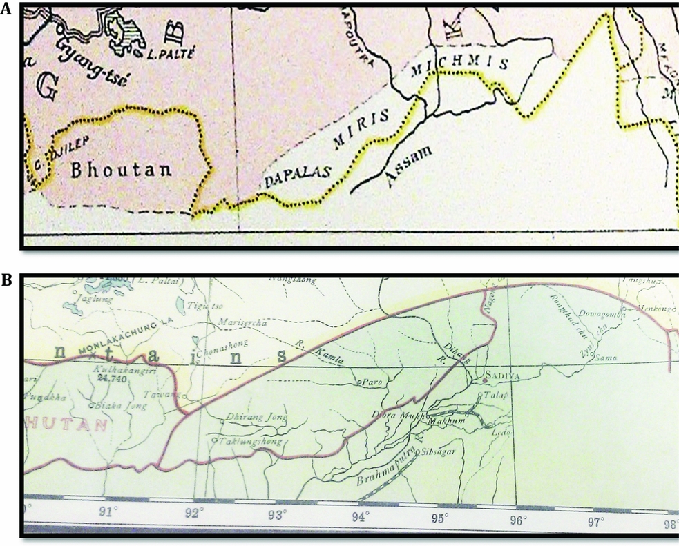
In addition, it is also useful to add that cartographic representations of these areas do attest to the distinctness of these parts from China proper. French explorer Fernand Grenard, who travelled extensively in Xinjiang and Tibet in the late nineteenth century, mapped large parts of present-day Arunachal Pradesh as distinctly non-Tibetan with a separate colour scheme from China (Figure 5a). They are marked as areas inhabited by Dapalas, Miris and Michnis in Grenard's map (though technically they are marked outside the limits of the Indian empire).
Representation of the Eastern Sector.

Rose notes that:
the Daphlas, the Miris, the Mishmis, the Singphos or Kachins, and the Nagas all live within this Brahmaputra basin of Assam, and, though little touched by the direct administrative agencies of the Indian Government, they have been visited from time to time by British officers and have acknowledged their Indian allegiance, whilst the difficult nature of their country and the lack of natural communications cut them off from the Chinese sphere in Tibet.Footnote 75
Similarly, another map published in The New Atlas and Commercial Gazetteer of China (published by the North-China Daily News and Gerald Ltd, Shanghai,; Figure 5b) depicts the McMahon line alignment with the exception of the Tawang area (which is shown as part of China).
It is important to note that for several points on the ‘McMahon line’, there was no sufficient information. The letter from the Viceroy, dated 21' November 1913 and repeated to Peking, notes that the:
proposals regarding Indo-Tibet boundary are based on recent survey and information obtained of limits of effective occupation and territorial rights on either side. . .We do not know source of Subansiri, nor the southern limits of Tibetan possessions in and south of Tawang. The line can only be defined in general terms as running in general south-westerly direction along mountain range which forms main northern watershed of rivers draining southward into the Brahmaputra basin until it reaches limit(s) of Tibetan district of Tawang, and thence following southern limits of Tawang to Bhutan. . .should question hereafter arise we can recognize Tibetan right to any area south of line to which her claims may be established.Footnote 76
It is evident that an Indian claim based entirely on ‘traditional boundaries’ for this region would be problematic. Nehru himself admits to the overall nature of this line:
There is the McMahon line. By and large, apart from minor variations, that is a fixed line, which some parts, in the Subanasiri area or somewhere there, it was not considered a good line and it was varied afterwards by us, by the Government of India. But, broadly, it follows the watershedFootnote 77 (italicized for emphasis).
That was before the 1962 war. Following the war, Nehru clarifies, “The Agreement of 1914 only formalised what was the traditional and customary boundary in the area which lies along the highest Himalayan watershed ridges”Footnote 78 (italicised for emphasis).
Conclusion
It is beyond the remit of this article to examine the 1962 war, or the policy influences in India and China that fomented an inflexible interpretation of boundaries. Nehru's own views were not entirely irredentist, to begin with. On the Western sector he held:
The actual boundary of Ladakh with Tibet was not very carefully defined. It was defined to some extent by British officers who went there. But I rather doubt if they did any careful survey. They marked the line. It has been marked all along in our maps. They did it. As people do not live there, by and large, it does not make any difference. It did not make any difference. At that time, nobody cared about it.Footnote 79
On the Eastern sector too his position was not entirely inflexible, noting that:
having accepted broadly the MacMahon Line, I am prepared to discuss any interpretation of the MacMahon Line; minor interpretation here and there; that is a different matter– not these big chunks but the minor interpretation whether this hill is there or this little bit is on that side or on this side, on the facts, on the maps, on the evidence available. That I am prepared to discuss with the Chinese Government.Footnote 80
Similarly, the Chinese attitude was not hardwired to the idea of irredentism or inflexibility in the beginning. One of the points, which Zhou Enlai (周恩来) conceded to Nehru in 1960, was:
Since we are going to have friendly negotiations, neither side should put forward claims to an area which is no longer under its administrative control. For example, we made no claim in the eastern sector to across south of the McMahon Line, but India made such claims in the western sector.Footnote 81
This was also clear from Zhou's interaction with the press in New Delhi that:
we have asked the Indian Government to adopt an attitude towards this western area similar to the attitude of the Chinese government towards the area of the eastern sector, that is, it may keep its own stand, while agreeing to conduct negotiations and not to cross the line of China's administrative jurisdiction as shown on Chinese maps.Footnote 82
The official Chinese position appeared to draw some support from cartographic representations elsewhere, such as the Times Atlas of the World (mid-century edition; 1958), where according to the Chinese, “the traditional Sino-Indian boundary line and the so-called McMahon Line were both drawn with the words ‘Disputed Area’ marked between the lines”.Footnote 83 However, The Times Index Gazetteer of the World (published subsequently in 1965) clarifies the location of Aksai Chin in Kashmir with the geographical coordinates of 35.08 N and 79.45 E (p. 14). The Gazetteer preface notes that the volume provides an instant reference to “where or which country in the world the sought for location belongs” (italics added for emphasis). In the case of Aksai Chin, it is reasonable to assume that a part of what comprised Aksai Chin was recorded as part of India, even though it may not corroborate the Indian claims up to the 80.30 E longitude line. Likewise, Tawang is listed in the Gazetteer as located in “Assam, India” with coordinates of 27.34 N and 91.54 E (p. 838). The Gazetteer recording presents itself in opposition to the controversy over the Times Atlas, where the latter was believed to have supplanted China's overall position.
Other cartographic representations such as in the 1961 Nelson's Concise World Atlas (printed in Edinburgh, Great Britain; Figure 6a) showed the India–China boundary in the Western sector approximating the ‘Macartney–MacDonald’ line alignment (at variance with India's current claims), even as the ‘McMahon line’ alignment is shown for the Eastern sector (at variance with China's claim). Even the The McGraw-Hill Illustrated World Geography, (ed.) Frank Debenham, (New York, 1960) Figure 6b retains the ‘McMahon line’ alignment for the Eastern sector (although the disputed status of Kashmir is highlighted in the Western sector).
Representation of the India-China boundary in international atlases.

Between India and China, the negotiating positions gradually hardened over time. Zhou's idea of maintenance of the ‘status quo’ (in 1960) was at variance with the idea of a swap-settlement (no territorial claims by China to the south of the McMahon line in exchange for a similar approach by India in the western sector) ingrained in Deng Xiaoping's (邓小平) proposal to settle matters on the basis of the existing status quo, i.e. as it existed in the early 1980sFootnote 84 (emphasis added). Deng's articulation that China “never asked for the return of all the territory illegally incorporated into India by the old colonialists after independence”Footnote 85 is linked to, and yet at variance with, China's subsequent articulations on Arunachal Pradesh (beyond just Tawang).
Currently, India and China hold on to an absolute reversal on the initial relatively conciliatory understanding. China claims the entire Arunachal Pradesh while India retains the Ardagh–Johnson alignment with respect to the whole of Aksai Chin, reflecting what has been the entrenchment of the narrative of ‘traditional and customary boundaries’. Ironically, both sides at one time, effectively, refuted the argument of traditional boundaries. The Chinese plenipotentiary at the Simla conference, in no uncertain terms, stated that:
The territorial limits of a State in any part of the world can only be decided by the connection which has lately existed between the territory and the state which claims to have it, and not by any remote connection, and still less by any such remote connection which has been long replaced by later ones. . .the territorial limits of Tibet in the time of the Tang dynasty (唐朝) cannot, therefore, be admitted as evidence of any value for her present claim to the regions of Chinghai, Batang, Litang and Tachienlu. If one were to abide by such hoary connection in deciding the limits of her territory, what could be said about the connection of the same nature which Tibet had once had, also in the time of the Tang dynasty, with the valley of the Ganges in India and what could be said about the subjugation of India by China in the time of the Yuan dynasty?Footnote 86
Likewise, Nehru stated in the Indian Parliament that:
The Chinese State today is a great, very big, colossal State. Was this Chinese State born as such from head of Brahma? How did it grow so big and great? Surely, in past ages by the ability of its people and the conquests of its warriors, in other words, by Chinese imperialism. . .But where do you draw the line from which a kind of certainty comes there is no imperialism after and only before? At times, if one discusses the history of Tibet, well, there were periods when the Nepalese armies occupied the Chinese capital. You go far enough. We had even in India, peaceful as we are, empires going right over to a large part of Central Asia, in Asoka's time, Chandragupta's time, the Kushan period, and all that. Now, where do you draw the line in history? History is full of changes, full of ups and downs, full of all kinds of things and full of the mixtures of people and countries. And if one does go back that way, there is no century in the wide world which may not be shaken to its foundations and split up and certainly the great Chinese State will not survive if that argument is applied. We do not apply that argument.Footnote 87
In the context of the evolution of boundary making in the Western and Eastern sectors, it is fair to conclude that present-day narratives on boundaries that stress ‘traditional and customary boundaries’ evolved over time. From a theoretical perspective, the political importance of these premises did not lie in their being ‘true’, or in the claim being ‘real’ or even the lines being consistent but in their being shared by a process of political selection and then being reified as ‘taken for granted’.Footnote 88 Clearly, the lines were mutable. In many ways, the intractability in the understanding today between India and China on boundaries as being ‘fixed and unchangeable’, valorised for national pride, in theory emerge from ‘institutional facts’ that exist within systems of ‘constitutive rules’.Footnote 89 This points to a need for new interpretations of ‘reality’ to be introduced to the conversations between India and China by changing the epistemic (and normative) premises of the understanding of boundaries.Footnote 90 And this flexibility, as this article points out, is latent in the fluidity of boundary lines that emerged and mutated during the course of boundary–making between the two countries.