Walls and other defensive structures provide a concrete manifestation of military conflict and serve as solid archaeological data for the study of ancient warfare. Most studies of Maya defensive systems have been either site specific or rely exclusively on comparisons to other Mesoamerican examples. There has been a general lack of rigorous comparison to defensive systems from other regions of the world. Much of what has been written about the defensive nature of the walls at Mayapan itself has relied primarily on ethnohistoric data to establish the military nature of the wall and has typically overlooked other important secondary functions of the massive construction. It is one goal of this article to put the fortifications at Mayapan into a broader cross-cultural context, comparing the form of the site's defenses to historically documented examples. This will be accomplished by applying a recent typology of defensive features developed by Keeley, Fontana, and Quick (Reference Keeley, Fontana and Quick2007). I will then continue on to explore a number of secondary functions served by the enclosure.
My recent survey work at the site included remapping the Mayapan wall with modern global positioning system (GPS) equipment, observing firsthand the configuration and present condition of the wall's gates. I further surveyed portions of the settlement zone located immediately outside of the wall up to a distance of 1 km from the wall (Russell Reference Russell2008). Survey and mapping was accompanied by extensive test pitting of architectural groups to determine both chronology and function of observed features. The densest settlement zones encountered beyond the fortification cluster close to the wall and within short distances of its entrances, suggesting that the location of gates greatly influenced the patterning of settlement outside of the walled enclosure. Clustering of residential areas near gates means that when under threat the site's inhabitants living beyond its defenses could rapidly flee inside to relative safety. This also suggests that much of the settlement area outside of the wall appeared after the wall was built. This is further supported by decreasing densities of artifacts as one moves away from the site center toward the wall and then past it. I did not conduct any new excavations of the wall itself. So, this article will rely to a large degree on earlier observations and maps made by twentieth century researchers.
Keeley et al. (Reference Keeley, Fontana and Quick2007) provide a specific, cross-culturally applicable set of features to look for in a defensive fortification: V-sectioned ditches outside of defensive walls, defensible gates, and bastions. The authors examined a number of historically documented fortifications and found that these features shared similar designs despite the time period, size of settlement, level of political complexity, even the construction materials and techniques used to build the enceinte or enclosure. Form clearly follows function for fortifications. The authors do not rely on features such as strategic placement of constructions on the landscape or the presence or absence of certain features like crenellations that may not have exclusively military function or are not likely to preserve well archaeologically. The partially preserved parapet along the top of Mayapan's wall falls into this category. I believe that both the parapet wall and the placement of certain gates on the landscape were part of a carefully planned fortification system at Mayapan. But, they are not the core on which my arguments are based. Specifically, I focus on the features of the Mayapan wall that suggest unambiguous defensive functions—the system of defensible gates. Neither ditches nor bastions are present at Mayapan.
An additional goal of this study is to outline several secondary functions of the massive feature. I will:
1) Demonstrate how peacetime movement of people and goods into the city was monitored and controlled by the city's elites.
2) Examine the layout of the wall and related features to highlight ritual functions served by the enclosure.
3) Make the case that the wall was a means for site rulers to control the masses of people living within it.
4) Examine the symbolic functions of the wall and how its meaning is reflected in a variety of colonial period documents.
Taken together, this will provide a far more comprehensive view of the wall's form and various functions than has appeared to date.
A REVIEW OF WALLED SETLEMENTS IN THE MAYA AREA
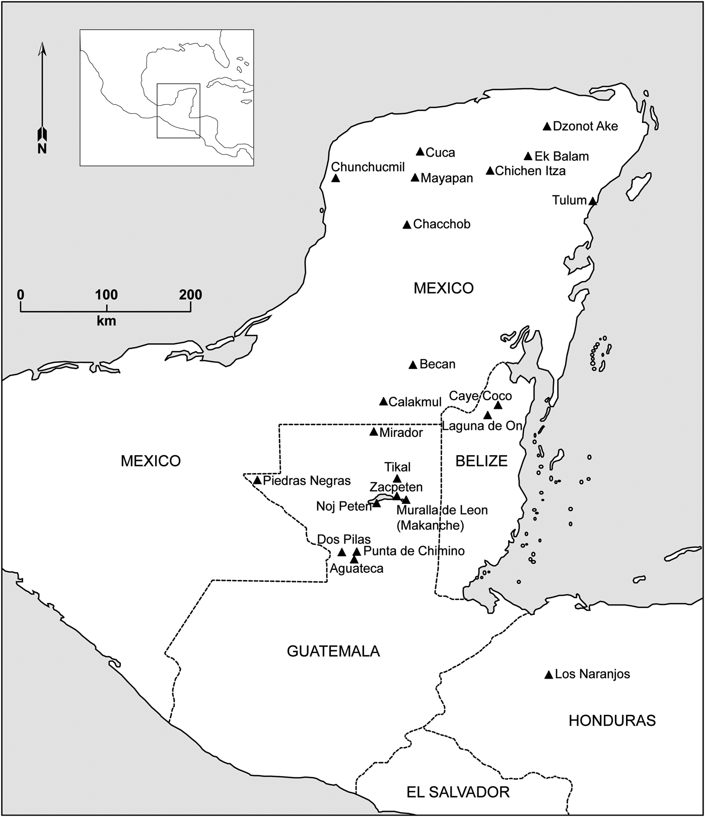
Webster (Reference Webster, Feinman and Marcus1998:324–325) suggested that there were three main types of fortification in the Maya area (Figure 1). First, there are those systems which protected large areas and functioned as “distant defensive screens” such as have been recorded Los Naranjos (Baudez and Becquelin Reference Baudez and Becquelin1973). Second are those that were erected immediately around site centers to protect the ruling elite such as those found at Tulum (Lothrop Reference Lothrop1924; Sanders Reference Sanders1960), Ek Balam (Bey et al. Reference Bey, Hanson and Ringle1997), Becan (Webster Reference Webster1976b), Chacchob (Webster Reference Webster1979, Reference Webster1980, Reference Webster1982), Cuca (Kurjack and Andrews Reference Kurjack and Andrews1976; Webster Reference Webster1978, Reference Webster1979, Reference Webster1982) and Dzonot Ake (Webster Reference Webster1978, Reference Webster1980, Reference Webster1982). The third kind of fortification, found only at Chunchucmil (Dahlin Reference Dahlin2000; Demarest et al. Reference Demarest, O'Mansky, Wolley, Van Tuerenhout, Inomata, Palka and Escobedo1997; Palka Reference Palka2001) and Mayapan (Brown Reference Brown1999; Masson et al. Reference Masson, Hare, Lope, Schwartz and Nichols2006; Masson and Peraza Lope Reference Masson and Lope2014; Milbrath and Peraza Lope Reference Milbrath and Lope2003; Paris Reference Paris2008; Peraza Lope et al. Reference Peraza Lope, Masson and Russell2005, 2006; Pollock et al. Reference Pollock, Roys, Proskouriakoff and Smith1962; Russell Reference Russell2008) were large enclosures intended to protect the majority of the urban population from attackers.
Map of the Maya area featuring fortified Maya sites mentioned in text.

Formal walls such as those at Mayapan are built during peacetime in anticipation of future hostilities or, better yet, to prevent attack entirely by making it too costly to adversaries. Unlike emergency fortifications (Dahlin Reference Dahlin2000; Demarest et al. Reference Demarest, O'Mansky, Wolley, Van Tuerenhout, Inomata, Palka and Escobedo1997; Palka Reference Palka2001; Webster Reference Webster, Feinman and Marcus1998), these constructions do not rely on materials taken from the site's structures. Rather the material was brought to the construction site, often from nearby barrow pits or quarries. Substantial limestone quarries are found in many locations around and in close proximity to the wall's exterior, although they do not connect to make a formal ditch (Russell Reference Russell2008:Figure 7.44). Mayapan's wall undulates and curves to include or exclude pre-existing architecture and natural features. It does not typically cross or incorporate architecture. The deliberate way that the wall avoids and snakes through the various architectural groups without disturbing them suggests that the wall is a late addition to the site, constructed after a significant amount of the population was already in place. Its continued presence would in no way suggest annihilation of the population as has been argued for emergency fortification (Dahlin Reference Dahlin2000). In fact, defeat for a center with a pre-planned, formal defensive system of this sort may involve its partial or complete destruction. As we will see, this was the fate of Mayapan's fortifications.
The need for fortifications rose and fell over time in the Maya area. These changes reflect evolving tactics, motivations, goals, populations and technologies associated with warfare. Preclassic fortifications from sites such as Becan (Ruppert and Dennison Reference Ruppert and Denison1943; Webster Reference Webster1972, Reference Webster1974), El Mirador (Dahlin Reference Dahlin1984), Los Naranjos (Baudez and Becquelin Reference Baudez and Becquelin1973) and Muralla de León (Rice and Rice Reference Rice and Rice1981), suggest a period of military tensions around the time that the first Maya states were emerging.
The Classic period saw sites such as Calakmul (Folan Reference Folan, Evans and Webster2001; Folan et al. Reference Folan, Marcus, Pincemin, Carrasco, Fletcher and Lopez1995) adopting walled fortifications possibly motivated by the tensions now thought to have existed between it and neighbor Tikal (Martin and Grube Reference Martin and Grube2000:24–52, 100–115). Recent work at Tikal (Silverstein et al. Reference Silverstein, Webster, Martinez and Soto2009; Webster et al. Reference Webster, Silverstein, Murtha, Martínez and Straight2004, Reference Webster, Murtha, Straight, Silverstein, Martínez, Terry and Burnett2007, Reference Webster, Murtha, Silverstein, Martínez, Straight, Mastache, Cobean, Cook and Hirth2008), on the other hand, refutes earlier findings that the large earthworks there were defensive in nature (Puleston Reference Puleston and Hammond1974, Reference Puleston1983; Puleston and Callender Reference Puleston and Callender1967), suggesting instead water control functions. Becan (Ruppert and Dennison Reference Ruppert and Denison1943; Webster Reference Webster1972, Reference Webster1974) and Los Naranjos (Baudez and Becquelin Reference Baudez and Becquelin1973) continued to be occupied throughout the Classic period, presumably maintaining the Preclassic fortifications. While present at several minor centers, walled fortifications around major centers remain relatively uncommon through the most of the Classic, possibly reflecting the introduction of Teotihuacan inspired Tlaloc-Venus or “star wars” (Freidel et al. Reference Freidel, Schele and Parker1993:296–297, 310–312, 323–324; Schele and Freidel Reference Schele and Freidel1990:130–131, 162–164). A main goal of these conflicts was to replace rulers of foreign sites rather than to destroy and depopulate them, perhaps making hardened defenses of the sites and their occupants less of a priority. Rice and colleagues (2009) argue that during most of the Classic period, warfare was largely ritualized with combat taking place between small groups and having little impact on commoner populations.
The Late Classic period and the unfolding Maya collapse saw a significant rise in the number of centers looking to either constructed or natural defenses for security, coinciding with the Putun Maya intrusion into the lowlands. This trend intensified through the Terminal Classic with the arrival of migrating Itza populations. Archaeological work examining defensive systems in the Petexbatun region in particular suggested a brand of warfare resulting in site destruction and abandonment. Sites in the area such as Dos Pilas, Punta de Chimino, and Aguateca show a mix of pre-planned and emergency fortifications (Demarest Reference Demarest1993; Demarest et al. Reference Demarest, O'Mansky, Wolley, Van Tuerenhout, Inomata, Palka and Escobedo1997; Inomata Reference Inomata1995, Reference Inomata1997). A number of important centers fell during this period including Chunchucmil (Dahlin Reference Dahlin2000; Demarest et al. Reference Demarest, O'Mansky, Wolley, Van Tuerenhout, Inomata, Palka and Escobedo1997; Palka Reference Palka2001) with its large emergency fortifications. Other sites apparently adopting fortifications in this period included Chacchob (Webster Reference Webster1979, Reference Webster1980), Cuca (Kurjack and Andrews Reference Kurjack and Andrews1976; Webster Reference Webster1978, Reference Webster1979), and Ek Balam (Ringle Reference Ringle2004; Ringle et al. Reference Ringle, J, Freeman, Hanson, Houck, Smith, Demarest, Rice and Rice2004). Dating of the fortifications at Ake (Garza and Kurjack Reference Kurjack1980; Roys and Shook Reference Roys and Shook1966) remains unclear, but may also be from the Late Classic as it appears to overlie numerous earlier sacbes (Webster Reference Webster1976a). Webster suggests a similar late date for the walls at Muna. Yaxuna (Ambrosino et al. Reference Ambrosino, Ardren, Manahan, Gubler and Martel2001; Ardren Reference Ardren1997; Stanton Reference Stanton2000; Suhler et al. Reference Suhler, Ardren, Freidel, Johnstone, Rice, Rice and Demarest2004) appears to have adopted the use of defensive walls as the site came under pressure from the newly dominant center of Chichen Itza. Xuenkal adopted walled fortifications late in its long occupation during the Terminal Classic based on the presence of Sotuta and Cepech ceramics recovered in recent excavations (Cortes-Rincon Reference Cortes Rincon2007:Table 5.1). Dzonot Ake also adopted fortifications around the same time (Webster Reference Webster1980).
Ethnohistoric evidence for the Postclassic period suggests that the arrival of Itza groups resulted in a series of site destructions and depopulations culminating in the founding of Mayapan. It further suggests that with the aid of imported Gulf Coast mercenaries known as the Canul, the rulers of Mayapan, in particular the Cocom lineage, set out on a significant diplomatic and military effort resulting in the incorporation of numerous new territories into a confederacy covering the majority of the Northern lowlands (Roys Reference Roys, Pollock, Roys, Proskoriakoff and Smith1962:38–49). With this backdrop it appears that the leaders of the site chose to construct an unprecedented defensive system. As noted above, its course deliberately deviates to enclose significant amounts of Late Postclassic architecture. The oddly amorphous shape of the wall certainly gives the general impression that it was fitted around a dense, well-established and sprawling urban community. Ethnohistoric data explored in more detail below offer additional support for a late construction. Additional excavation, however, would be required to fully confirm this interpretation. To date, excavations have not penetrated the wall itself. A firm date could be well established by the presence of Chen Mul ceramics in construction fill, as they date to the latter half of the city's occupation.
Several other Northern lowland sites such as Ichpaatun (Sanders Reference Sanders1960), Tulum (Lothrop Reference Lothrop1924; Sanders Reference Sanders1960), and Xelha (Lothrop Reference Lothrop1924) also adopted walled defensive systems in the Late Postclassic. Other lowland settlements of the period such as Noj Peten (Tayasal) in the Peten Lakes region of Guatemala (Pugh Reference Pugh2003; Rice Reference Rice1987:235–240; Rice and Rice Reference Rice and Rice1981; Rice et al. Reference Rice, Rice, Pugh, Ruiz, Marquínez, Campillo, de León, García-Gallo and Castro1998), as well as, Caye Coco and Laguna de On (Masson Reference Masson2000) in northern Belize cropped up on islands, relying on the water to help thwart possible attackers. Still others like Punta de Chimino (Demarest Reference Demarest1993) and Zacpeten (Rice et al. Reference Rice, Rice, Pugh, Ruiz, Marquínez, Campillo, de León, García-Gallo and Castro1998; Rice et al. Reference Rice, Rice, Pugh, Polo, Rice and Rice2009) chose locations that were bounded on multiple sides by water then employed additional fortifications on the vulnerable side, even digging canals cutting them off from land entirely. These natural defenses are reminiscent of the Aztec island capital of Tenochtitlan (Smith Reference Smith2003:183–191) with its multiple defendable causeways and drawbridges, albeit on a much smaller scale. With no such natural defenses to call upon, the planners at Mayapan turned to a single, massive wall, the likes of which had never been seen in the region before.
ESTABLISHING THE DEFENSIVE FUNCTION OF WALLED ENCLOSURES
Not all walls are primarily defensive in nature and secondary functions should not be overlooked in their study. So, how is the archaeologist to distinguish between a defensive construction and one that may have served other uses such as a simple, formal site boundary? Webster (Reference Webster1978) suggests that establishing the primary function lies in eliminating competing explanations as well as demonstrating “that the size and configuration of boundary features are consistent with defensive functions.” He also suggests establishing a motive for construction—a real or perceived threat. In Mayapan's case, that motivation can be found in the ethnohistory of the Late Postclassic and early Colonial periods which document extensive conflict across the Northern lowlands, including the destruction and depopulation of entire towns and cities (Roys Reference Roys, Pollock, Roys, Proskoriakoff and Smith1962:38–49). Other factors such as internal revolts were also an issue (Masson and Peraza Lope Reference Masson and Lope2014; Roys Reference Roys, Pollock, Roys, Proskoriakoff and Smith1962). I will return to a full discussion of the size and configuration of the Mayapan walls shortly.
The current study draws on a model of defensive fortifications devised by Keeley and colleagues (2007). By examining historically documented sites they found that V-sectioned ditches, defensible gates and bastions were the most consistent indicators of defensive functions for walled enclosures. The system at Mayapan contains defensible gates. But, it lacks the other two features. The authors do not consider certain attributes of many fortification systems including, architectural features such as crenellations (which may not preserve well or have more ambiguous functions) and defensive use of natural landscape features. I discuss both in this specific case as I believe that both the partially preserved parapet along the top of the wall and the placement of certain gates on the landscape were intentionally defensive at Mayapan.
FORM OF MAYAPAN'S CITY WALL
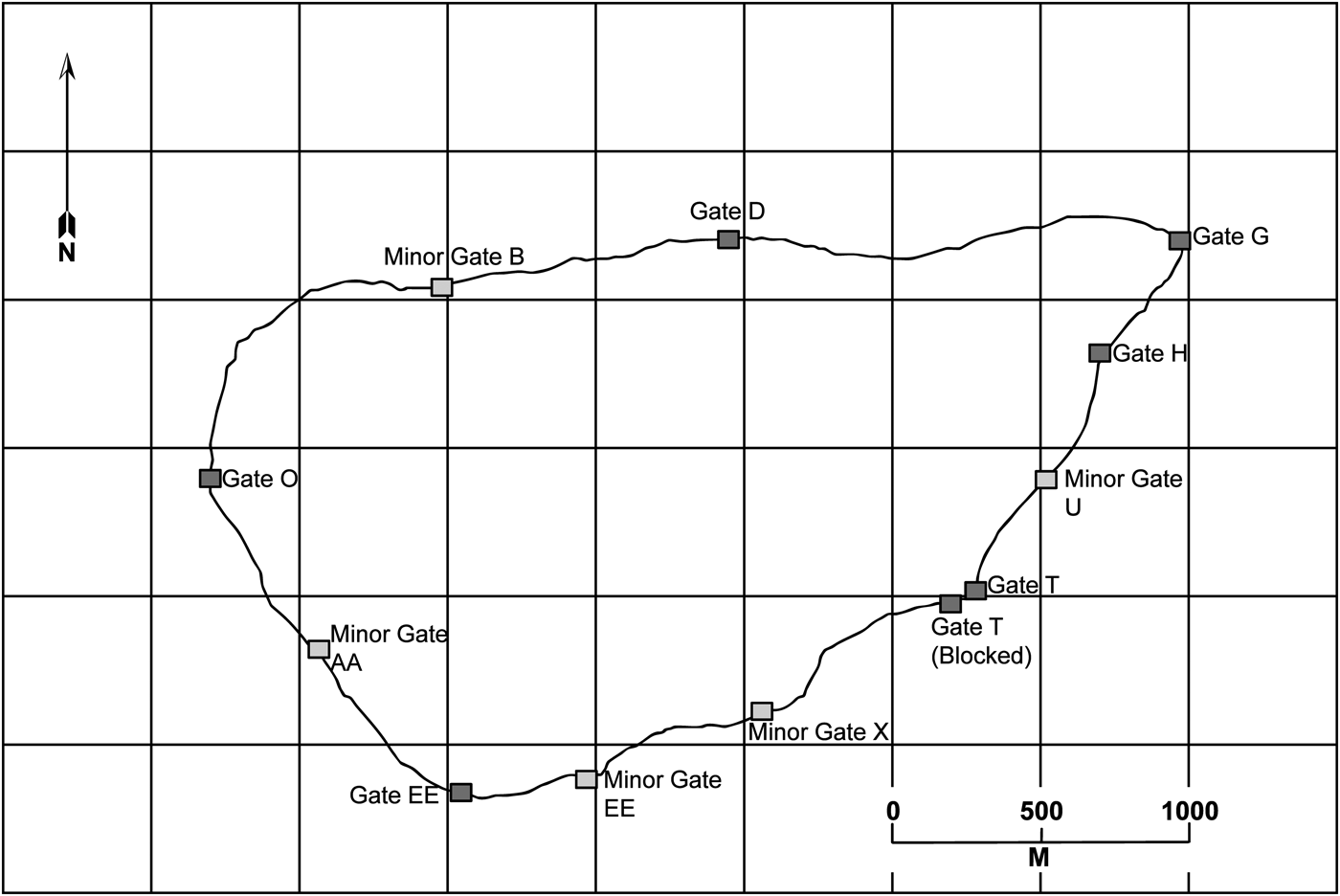
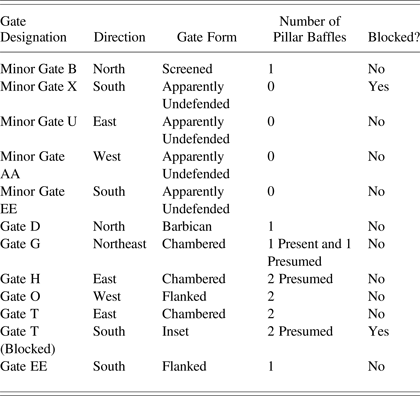
The 9.1 km-long enceinte at Mayapan enclosed 4.2 km2 of the site. It consists of an encircling curtain wall (Keeley et al. Reference Keeley, Fontana and Quick2007:57) with at least 12 reasonably evenly spaced entrance gates located along its circumference (Figure 2). Of these, seven are considered “major gates” and five “minor gates.” It is possible that other gates once existed that have been destroyed in later years as there are numerous other breaks in the remains of the wall that accommodate modern roads and foot trails (Table 1). Most are easily identified as later disturbance but, exactly what was disturbed is impossible to say.
Map of the Mayapan wall showing location of both minor and major gates.
Details about form and orientation of all 12 known gates in the Mayapan wall
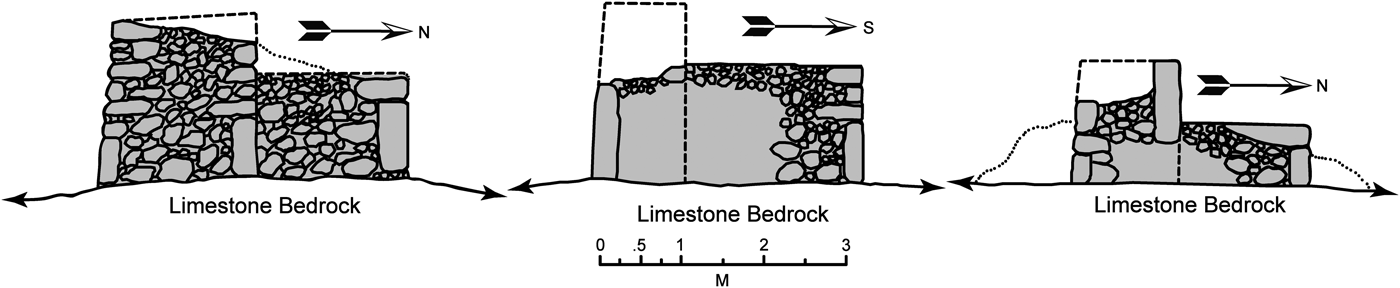
The wall itself was constructed in two stages which are easily seen in cross section (Figure 3). The first involved construction of the dry-laid, outer wall and parapet between 1.5 and 2 m tall and about 1 m wide. The second phase was construction of a lower inner walkway which Shook (Reference Shook1952) called a “bench.” This walkway is typically a little less than a meter shorter than the outer wall and offers about 2 m of surface to move along or use as a platform for firing projectiles while protected by the parapet and likely palisade. The masonry of both the wall and walkway consists of dry laid, rough-cut, limestone slab retaining walls which were then filled with rubble and soil. The outer surface was apparently coated in lime plaster. This construction technique is common throughout the site's architecture. Shook (Reference Shook1952:10–16) also found remains of lime plastered floors at many of the gates where he excavated. Limestone outcrops and surface cobbles are ubiquitous around the site, providing ample raw materials for construction (Russell Reference Russell2008:15–18).
Cross section drawings of three points along the wall showing outer wall and bench construction method. Redrawn from Morris (1952:Figures 1a–1c). Wall portion was most likely topped with a wooden palisade of the type witnessed and described by Díaz del Castillo (Reference Díaz del Castillo and Keatinge1927).
As noted above, the enclosure at Mayapan appears to have been built sometime after settlement patterning had been well established, likely in response to growing inter- and intra-site violence in the last century of occupation (Masson and Peraza Lope Reference Masson and Lope2014; Roys Reference Roys, Pollock, Roys, Proskoriakoff and Smith1962). This period also saw the arrival of Canul mercenaries imported from the Gulf Coast who introduced new methods of warfare and weaponry (Masson and Peraza Lope Reference Masson and Lope2014). As a result, the unusual feature may well reflect Gulf Coast/central Mexican influences. The wall's unusual layout is roughly oval in shape measuring about 3,200 m east to west and 2,000 m north to south. Close examination of the Carnegie Institution of Washington map compiled by Jones (Reference Jones1957) reveals both large scale decisions to incorporate expansive existing settlement zones and more fine grained adjustments to the course of the wall to incorporate single architectural groups. The wall extends out in the northeast of the city to enclose the area around the Itzmal Chen temple/cenote complex. I have argued elsewhere (Russell Reference Russell2008:666–671) that this portion of the city was occupied sometime during the Terminal Classic period, well before the founding of the site's main monumental center to the west and retained its importance throughout the site's history.
The enclosure's large size allows it to surround some 4,000 structures. Results of my own survey work suggest that approximately 1,200 structures are found outside of the wall within a distance of 1 km, and planned LiDAR mapping efforts at the site should refine this estimate. Most of the residential structures at the site are found within or close to the wall (within a distance of roughly 500 m). Beyond that point, structures tend to be related to agricultural, livestock, and lime plaster production. Survey work additionally documented three shrines located at the interface of the residential zones and these economic production areas which I will discuss in more detail later in the article. The vast majority of the residential population was protected by the wall. Even those residing outside would have been able to retreat inward rapidly if needed. As noted previously, this is extremely rare in Mesoamerica where the majority of defensive enclosures surround only important parts of sites that would have served as much smaller refuges.
Late construction of the feature poses numerous interesting questions, many of which I will address below, while others are beyond the scope of this paper. What was the labor force employed in its construction and what was required in terms of manpower to do it? Were they corvée laborers? Was slave labor involved? Were imported mercenaries called upon to help construct it? Some mix of the above? To what degree was placement of the gates determined by pre-existing routes of travel and to what degree were new ones created by it? How did the city's residents view the wall? How were people's lives different after its construction? Was it a well received defense against external threats or was it resented as a restriction on the freedom of everyone living inside of it? What were the motivations behind its construction at that specific point in time? How did it serve the goals of those directing and funding its construction? How well did it serve those goals? What were its economic impacts, both the construction itself and its effects on commerce and transport?
ETHNOHOSTORY OF “FORTRESS” MAYAPAN
The unusually detailed ethnohistoric record we have for this late site gives us hints about how the enclosure was viewed by local populations at the time of Spanish contact. The Maya chronicles (Brown Reference Brown1999:484–572; Roys Reference Roys, Pollock, Roys, Proskoriakoff and Smith1962:68–77) make it clear that its authors considered Mayapan's walls to be primarily defensive fortifications. There are repeated references to Mayapan as a “fortress” in the stories of the later days of the site. One such passage from the Tizimin Chronicle (cited in Roys Reference Roys, Pollock, Roys, Proskoriakoff and Smith1962:72) reads, “8 Ahau was when there was fighting with stones in the fortress of Mayapan, because of the seizure of the wall, because of the joint government within the town of Mayapan.” Ultimately, this “seizure” of the walls appears to have taken place from within during the last days of the city. Another reference (Roys Reference Roys, Pollock, Roys, Proskoriakoff and Smith1962:73) states, “Katun 4 Ahau was when occurred the pestilence, when the vultures entered the houses within the walled enclosures [or fortresses].” It is somewhat unclear whether this passage refers to the main defensive wall or the low stone wall or albarrada enclosures that typically surround the site's individual residential groups.
The remaining chronicles make similar references which are variously translated as “fortress” or “walled enclosure.” Tozzer (Reference Tozzer1941:23–26) provides two useful references to walls at the site. The first comes from the Relación de “Quinacama” and Muxuppipp which reads, “This city conquered all these provinces, for it was very strongly built, walled in like those of our Spain, and within the walls there are reckoned to have been more than sixty thousand dwellings, not counting the environs.” This passage clearly indicates a belief that the wall was a key to Mayapan's military conquest of surrounding areas. The second, longer passage from the writings attributed to Diego de Landa reads:
This Kukulcan established another city after arranging with the native lords of the country that he and they should live there and that all their affairs and business should be brought there; and for this purpose they chose a very good situation, eight leagues further in the interior than Merida is now, and fifteen or sixteen leagues from the sea. They surrounded it with a very broad stone wall, laid dry, of about an eighth of a league leaving in it only two narrow gates. The wall was not very high and in the centre of this enclosure they built their temples, naming the largest, which is like that of Chichén Itzá, the name of Kukulcan, and they built another building of a round form, with four doors, entirely different from all the others in that land; as well as a great number of others round about joined together. In this enclosure they built houses for the lords only, dividing all the land among them, giving towns to each one, according to the antiquity of his lineage and his personal value. And Kukulcan gave a name to this city—not his own as the Ah Itzas had done in Chichén Itzá, which means the well of the Ah Itzas, but he called it Mayapan, which means ‘the standard of the Maya,’ because they called the language of the country Maya and the Indians (say) Ichpa which means “within the enclosure.” (Tozzer Reference Tozzer1941:23–24)
These descriptions do not match well the remains that have been documented on the ground. As we know from the Jones (Reference Jones1957) map, the main wall only encloses some 4,000 structures, far short of the number cited in the quote above. At the same time it is clearly larger than the one eighth of a league mentioned by Landa. As previous scholars including Tozzer (Reference Tozzer1941:24) and Shook (Reference Shook1952) have pointed out, it appears that these two passages discuss two different walls, one larger wall enclosing thousands of dwellings and a second much smaller wall enclosing just the temples and houses of the elites. While no remains of inner wall have been recorded, it is possible that the colonial Rancho San Joaquin wall incorporated and relocated it (Brown Reference Brown1999:496–499). There are indications that there were two main entrances to the central precinct at the site, one through a vaulted arch to the east of the monumental center and another from the west (Russell Reference Russell2008:717–725). If correct, it would lend some support to the second passage describing a smaller inner wall around the site center, as would the fact that the passage describes the wall being constructed at the time the site was founded rather than late in its history as seems to be the case for the main fortification. It is quite possible that the inner wall was simply no longer needed once the outer wall was in place and that it was removed in antiquity. There is of course also the possibility that the account is simply incorrect.
EARLY ARCHAEOLOGICAL RESEARCH ON MAYAPAN'S CITY WALL
The fortification was first explored in detail when Ralph T. Patton visited the site in the late 1930s and mapped the wall and many of the structures in the site center under the auspices to the Carnegie Institution of Washington. Unfortunately, Patton did not publish his findings. However, his notes and maps were used in the preparation of later publications on the site including the final Jones (Reference Jones1957) map of the site. During his work, Patton identified nine gates in the wall. Additional entrances were later located by Jones during his extensive mapping work at the site. An incomplete and unpublished manuscript from Patton's work (Andrews and Patton Reference Andrews and Patton1938) recounts his initial thoughts on the defensive nature of the wall which I will detail here at some length due to their lack of publication elsewhere. Reading Andrews and Patton's (Reference Andrews and Patton1938:204–205) manuscript reveals that he had doubts about it being an effective defensive barrier:
Function of the Wall
It is natural to suppose that a wall encircling a city served primarily for defense. Certain characteristics of that at Mayapan, however, make it a rather poor fortification:
1. The masonry structure is low. (Added height may be given by palisades.)
2. The entrances appear to have been located for convenience rather than protection, both in number and distribution.
3. The terrain is not used to the best advantage in the course of the wall.
4. The large and irregular size of the enclosure could not have been intended to secure a maximum defensive water supply. One cenote lies just 30 m outside of the wall.
5. The size and distribution of the remains within the walled enclosure seem to lack the compactness one would expect for a defensive unit. We are ignorant of course of the extent to which the areas inside the city were populated. Nevertheless, it is the usual custom at fortified cities to wall in only a concentrated central enclosure, thus effecting maximum economy of the actual works to be defended. The wall at Mayapan ignores this sensible usage, and would be extremely difficult to defend. It is at least five times the length of any similar construction known in New World prehistory.
After wrestling briefly with the inconsistencies in ethnohistoric descriptions of the site's wall(s) mentioned above, Patton returns to his discussion of the barrier's function. Despite early reservations, Andrews and Patton (Reference Andrews and Patton1938) still seem to settle on defensive functions for this structure:
Other factors indicate strongly that the wall was defensive in nature. In the first place, in a period we know as decadent to the extent that the most important ceremonial constructions were built with a minimum of care and effort, one doubts strongly whether for the purposes of mere symbolism the natives would have built a structure nine kilometers long involving the cutting, transportation and laying of well over two hundred million pounds of stone!! Knowledge gleaned from early histories indicate that in its final period the city of Mayapan enjoyed a military hegemony over large portions of an unwilling Yucatan, from whom they extracted tribute and sufficient hatred to culminate in their eventual destruction. A defensive wall would have been extremely useful. And we have no knowledge of any such constructions elsewhere in the area serving any other purpose.
A wooden palisade based upon the permanent masonry bastions around Mayapan would have made them a formidable fortification. And such palisades are known to have surrounded at least a large portion of both north and south Yucatec towns at the time of the conquest*. Lothrup [sic] further believes that many of these were actually walled with stone.
* Bernal Díaz del Castillo (Reference Díaz del Castillo and Keatinge1927. p. 69) describes a city of the province of Cehache in the south of Yucatan as “a newly built town, fortified and barricaded, with very strong palisades in two circles, one of which was like a barbican, with loop holes and trenches sunk before it.”
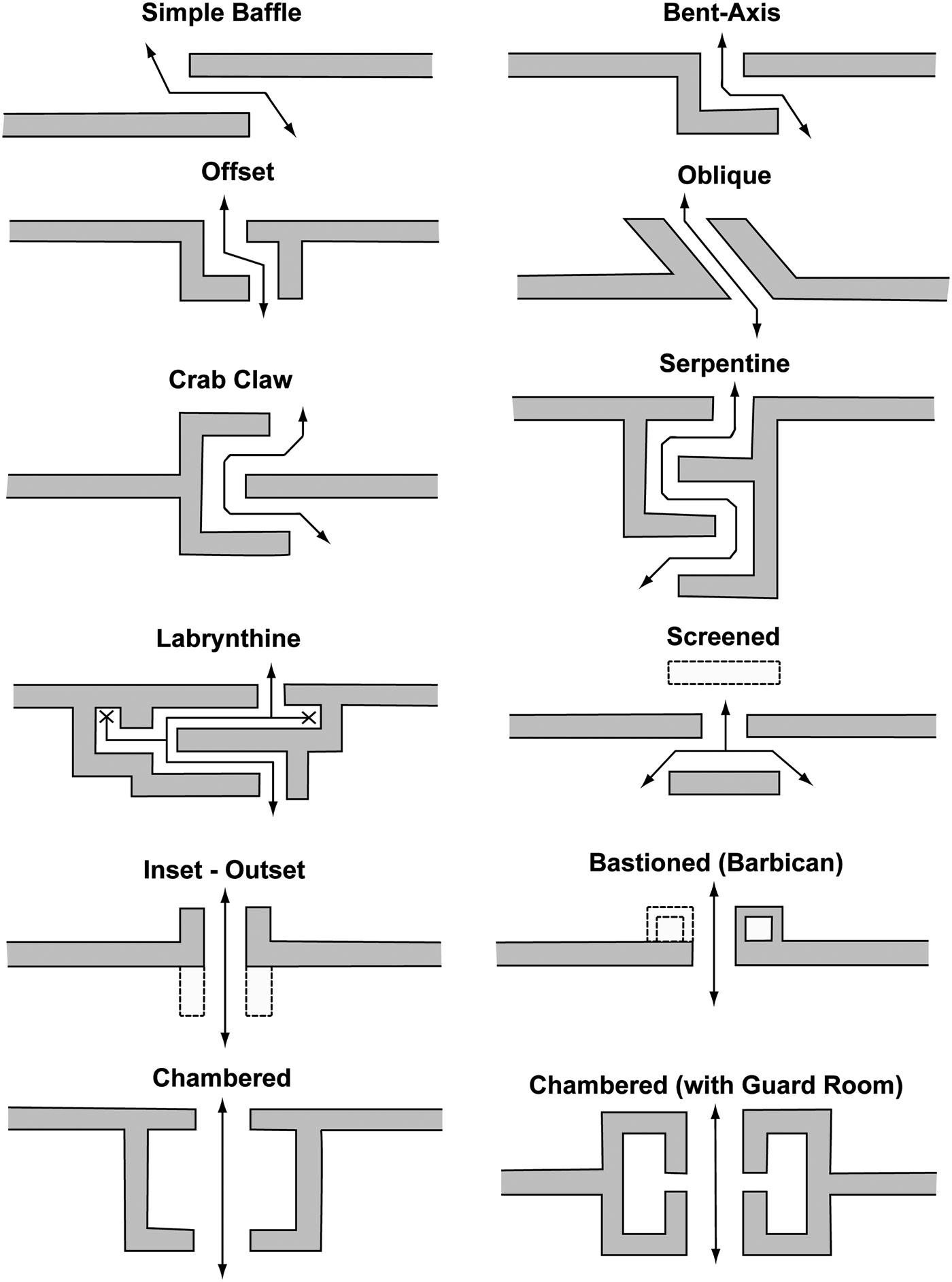
(Andrews and Patton Reference Andrews and Patton1938:206–207)Patton's observations on the features of the wall and his recognition of the conflict between a supposed smaller inner wall and the large outer wall described in ethnohistoric accounts (Tozzer Reference Tozzer1941) were significant contributions, as was his linkage of the form of the wall and its likely palisades with the description of early Colonial period fortified towns discussed by Díaz del Castillo. Fortunately for him, the barbican he described had been abandoned just prior to his arrival eliminating the need to breech its defenses. We will see below that Mayapan too has an outwardly projecting bastioned (barbican) gate, like the one noted by Díaz del Castillo (Reference Díaz del Castillo and Keatinge1927) in his chronicles (Figure 4).
Diagrams of historically and cross-culturally documented defended gate forms. Redrawn from Keeley et al. (Reference Keeley, Fontana and Quick2007:Figure 3).
While Jones was mapping the bulk of the site, including the full route traversed by the wall, Shook (Reference Shook1952) was focused on mapping and testing the gates in detail. He mapped all seven major gates. Of these five were partially excavated. Gates G and H were not excavated during the team's work. In the latter case Shook's reporting notes that Gate H did not present enough soil to make the preservation of remains possible. He does not offer a reason for not breaking ground at Gate G. He also tested and mapped two of the five minor gates, Minor Gates B and AA. Only half of each gate was excavated. His excavations extended in a radius of 50 m from the gate and were intended to locate associated architectural features like guard houses or armories and to determine if there were any signs of ritual dumps of ceramics just outside of the gates. He was also looking for evidence of conflict at the gates themselves. All of the excavations were carefully backfilled to prevent increased deterioration of the wall resulting from the work. The excavations yielded only “a scant quantity” of artifactual remains and produced no scatters of weapons that would suggest a specific conflict event. However, the detailed maps and observations he provided greatly inform the observations and arguments presented below.
NEW EVIDENCE OF WARFARE AND MILITARISM AT MAYAPAN
Our ongoing work and that of Peraza Lope's team from the Instituto Nacional de Arqueología e Historia (INAH) have uncovered significant evidence of state promoted militarism, sacrifice of war captives and specific warfare events in recent years (Masson and Peraza Lope Reference Masson and Lope2014; Milbrath Reference Milbrath2005; Milbrath and Peraza Lope Reference Milbrath and Lope2003). As suggested by ethnohistoric documents, sacrifice was apparently common. The Q-89 platform/altar which sits in the courtyard in front of burial shaft temple Q-95 was adorned by numerous skeletal heads and most likely served as a skull rack or tzompantli like the much larger example at Chichen Itza. Modeled stucco work from the now exposed façade of an early construction phase of the central Q-162 radial temple depicts skeletal individuals flanked by floating sacrificial knives that look strikingly like those depicted by the Aztecs. The heads are replaced by small niches that contained cranial fragments and even ceramic mandibles, apparently used to prop up jawless trophy skulls from war or sacrifice. Alternately, Milbrath identifies the knifelike features as bee wings, interpreting one figure to be a skeletal form of the Maya bee god (Milbrath et al. 2003:Figure 16). Mass graves from the center, including one from the Templo Redondo contain numerous individuals, likely sacrificial victims as do a series of burial shaft temples around the city. Additionally, the enigmatic semi-circular structure Q-84 has been linked with gladiatorial sacrificial ritual where prisoners were tethered to a stone and forced to fight with mock weapons. Many temples are associated with tapered sacrificial stones. One example from Itzmal Chen depicts a sculpted feline at its base, a possible reference to a specific military order. State-sponsored artwork in the site center frequently features militaristic themes, including some that appear to reference specific military orders associated with various animals as is common in the artwork of Chichen Itza and central Mexico.
Ethnohistoric sources tell of Canul mercenaries introducing the bow and arrow and a number of other military technologies late in site history. Bows were said to be vastly superior to existing weaponry, which reportedly relied on spear throwers as their main projectile type (Roys Reference Roys, Pollock, Roys, Proskoriakoff and Smith1962:58–59). Much hunting relied on traps and snares. The introduction of the bow led to an arms race of sorts with the mercenaries having an immediate advantage over local populations, including those from competing lineages in the city itself. Soon the new technology was assimilated by the general population, a fact attested to by the widespread distribution of small, side-notched arrow heads around the city. Landa (cited in Roys Reference Roys, Pollock, Roys, Proskoriakoff and Smith1962:59) describes the events in the following terms; “And the Yucatecans, finding themselves in this situation, learned from the Mexicans the use of arms, and they soon became masters of the bow and arrow, the lance and the axe, their shields and jackets made strong with salt and cotton, as well as other instruments of war, so that finally they neither admired the Mexicans nor feared them; on the contrary they took no account of them; and in this situation they lived several years.”
Analysis of extensive lithic collections from more than a decade's work including surface collections, test pits, and horizontal excavations show a well-armed populace (Masson and Peraza Lope Reference Masson and Lope2014). Both projectiles and pointed knives are common in many different contexts. Combined they account for 27.1% of all formal lithic tools recovered. Projectile points have been recovered at every single horizontally excavated structure we have worked on to date. They have been found in high percentages in commoner (L-28) as well as elite (Y-45) houses suggesting the importance of warfare to both groups of society. Projectile points break down into two main size classes: (1) small, typically basally notched arrow points made by reworking a unifacial obsidian blade or bifacially knapped in chert or chalcedony, and, (2) a slighter larger variety that may have been either arrow or atlatl points. Points were probably made when needed by most households in the community. The residents of the city even appear to have had a booming industry growing their own arrow shafts. The Standley cactus (Cereus yucatanensis) is found in abundance throughout the site but is far less common in other parts of the northern Yucatan (Brown Reference Brown1999:255). When they die or a limb is removed, the bulk of the plant rots rapidly away leaving behind a large number of straight, woody shafts that would have been appropriate for the task.
Projectile points and knives are both key components of a lithic tool collection recently excavated from a mass grave located just east of the H-15 colonnaded hall in the Itzmal Chen temple-cenote group (Paris and Russell Reference Paris, Russell, Masson, Lope, Hare and Russell2012). Lithics recovered from the large deposit were 80% projectile points. Many of these were very well made bifacial points, suggesting a high degree of skill and investment when compared with the typical small, reworked obsidian blade variety. This may tell us something of the relative investment in points made by military specialists and those producers who were primarily hunters. An additional 10% of the collection was comprised of pointed knives. A similar example was found embedded in a victim's ribs from a burial near Q-79/Q-80 (Adams 1953:Figure 1). Masson and Peraza Lope (Reference Masson and Lope2014) argue that this mass grave and another excavated near structures Q-79/Q-80 in the site center most likely contain war victims tied to a period of internal strife in the mid-1300s that foreshadowed its eventual fall (Paris and Russell Reference Paris, Russell, Masson, Lope, Hare and Russell2012; Peraza Lope et al. Reference Peraza Lope, Masson, Hare and Kú2006; Serafin Reference Serafin2010). The Itzmal Chen mass grave contained 18–20 individuals, mostly adults who had been killed, their bodies burned then their bones smashed to small pieces. Interestingly, a single adult male skull was burned but spared smashing. Missing its mandible, it was placed upright, facing west in a pit excavated in the center of the deposit. We believe these were the elite patrons of the Itzmal Chen group. Unceremoniously deposited with the victims of this violence were numerous smashed, anthropomorphic Chen Mul effigy censers which made up 30% of the ceramic material recovered, indicating that defacing religious symbols of one's enemies was important in some Late Postclassic Maya warfare. Smashed effigies were also a large part of the Q-79/Q-80 mass grave deposit. Calibrated radiocarbon dating of bone samples collected from the Itzmal Chen material produced a date of a.d. 1271–1394. Dating for the Q-79/Q-80 deposit is similar yielding a.d. 1200 to 1390 (Peraza Lope et al. Reference Peraza Lope, Masson, Hare and Kú2006). Consistent with this are data showing the burning and abandonment of a number of buildings around the same time, one of these buildings was the adjacent H-15 colonnade. Two important ethnohistorically reported events occur in this window. First was a period of internal “revolution” dating to Katuns 9 through 5 Ahau (a.d. 1302–1362). This was followed in Katun 3 Ahau (a.d. 1362–1382) by a purge or inquisition of sorts that resulted in some elites being killed and their bodies desecrated in a description that recalls the completely disarticulated and highly fragmentary state of the bones recovered from both deposits (Roys Reference Roys, Pollock, Roys, Proskoriakoff and Smith1962).
Other weapons may also have been used by Mayapan's combatants (Masson and Peraza Lope Reference Masson and Lope2014). Obsidian blades are ubiquitous around the site and may have been fitted into wooden weapons. High densities of obsidian blades were recovered from the Itzmal Chen mass grave. The context was second only to two known production sites in density of blades excavated. They are not discussed in colonial accounts, however, and their use as weapons remains uncertain. They may also have been used in post-mortem defleshing of the victims or even present in fill soil used to cover the deposit. The possible use of slings, which is also suggested in ethnohistoric accounts, is indicated by the presence of at least one skull with an apparent blunt force trauma consistent with that weapon. Some of the worked limestone balls and other stones currently identified as hammer stones for knapping may have been sling stones. Axes, which are specifically referenced in the above list of weaponry adopted from the Canul, are mainly linked to craft production locations. So, they appear less key to Mayapan's arsenal of weaponry than Colonial period documents would suggest. Their longstanding association with decapitation and ritual sacrifice in Mesoamerica may have made them useful in more limited ritual contexts and they are associated with some temple locations such as Itzmal Chen's H-17 (Delgado Kú et al. Reference Delgado Kú, Masson, Ojeda and Russell2009). It is notable that none were recovered from the nearby Itzmal Chen (H-15) mass grave.
GATES AS KEY DEFENSIVE FEATURES
Keeley and his colleagues (2007) published 12 specific plans for defended gates (Figure 4). Among these, the authors identify three main forms of defended gate: baffled gates, screened gates, and flanked gates. Among the most popular forms worldwide are baffled gates (also known as lateral, bent axis, offset, staggered, crab-claw, serpentine, and labyrinthine). The goal of these gates is to slow entry and force attackers to turn a corner, thereby exposing their flanks if carrying a shield. Once through, their already reduced numbers could be cut down even further by overwhelming forces using projectiles or melee weapons behind cover of the wall. These features range in complexity of design. They can be as simple as overlapping the end segments of the wall into complex labyrinthine designs that involve many turns and even dead ends or traps. The authors suggest that because these gates are difficult for everyday traffic to negotiate, they are primarily used for narrow secondary gates or “sally ports,” gates used to launch counter-attacks from within the wall. Early baffled gates are found in many regions including Africa, Mesoamerica, and eastern North America. They note that even after gun powder weapons such as cannons were developed, these gates remained popular. Screened gates are essentially double facing baffled gates formed by placing a screen or wall section in front of the gate, behind it or both. This design was popular with Roman fortifications and fortified camps. Flanked gates are entrances with straight or direct pathways. But, they were also flanked on one or both sides by walls or towers that served as platforms for massing fire on attackers. These gates form straight passageways that can be blocked on one or both ends. Attackers can be forced to breech a second, inner entrance under tight space and heavy fire conditions. The authors correlate this form with “main gates” where everyday peace time traffic is better accommodated. Several variants of each of these three broad categories exist at Mayapan.
One variant of the flanked gate with particular relevance to this study are chambered gates that have an inner and outer portal separated by a small open space or guard room(s). In some cases these portals project outward from the wall (bastioned or barbican gates). The authors suggest that the open spaces or chambers in these gates served as space for people monitoring traffic flow, collecting taxes, tolls, etc. Modern day Manhattan accomplishes the same function today by setting up toll booths at tunnels and bridges entering the city, the natural choke points for traffic flow.
THE GATES OF MAYAPAN
According to the Keeley et al. (Reference Keeley, Fontana and Quick2007), defensive city walls typically exhibit a mix of gate forms reflecting their individual functions. Some facilitate larger scale movement of peacetime traffic. Others were designed to slow attackers allowing defenders to face fewer at a time and force them to expose their flanks to attackers while entering. Still others are essentially complex traps awaiting those successful enough to get that far. All gates restricted the number of people who could pass at one time to lesser or greater degrees. Given the number and variable placement of gates around Mayapan's enceinte, we should expect to find a mix of defended gate forms employed. Close examination of the entrances reveals just such a mix of gate features (Table 1).
Mayapan's enceinte has numerous gates whose form and placement on the landscape provide a wealth of support for the defensive nature of the wall. Patton's (Andrews and Patton, Reference Andrews and Patton1938) observations in the draft manuscript discussed earlier contain only the hand drawn squares with labels marking where the maps he made of the gates were to have gone…eventually. To the best of my knowledge these have not appeared elsewhere. Fortunately, the detailed maps made by Shook (Reference Shook1952) provide all the information we need to discuss their design features.
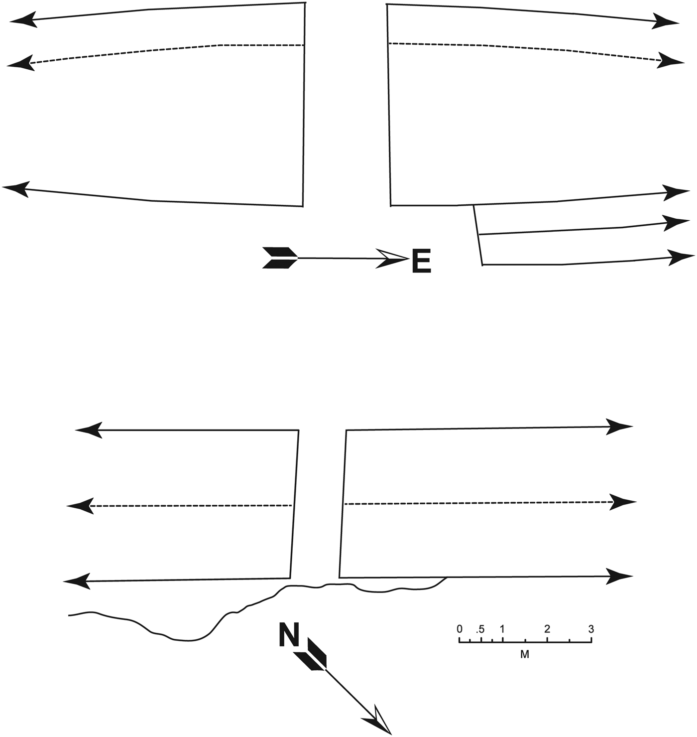
The Carnegie team (Shook Reference Shook1952) identified two main classes of gates, “major gates” and “minor gates.” They are distinguished in part by the presence or absence of clear defensive features. Minor gates generally lack the tell-tale features of defended gates (Figure 5). They are very narrow and it is likely that in times of conflict the minor gates were simply walled up. Minor Gate X was, in fact, found blocked up when encountered by Shook in 1952. This and blocked Gate T (discussed below) may suggest just that kind of response to hostilities. On the other hand, it is possible they were blocked to channel peace time traffic in ways more beneficial to those controlling the barrier. Minor Gate B was slightly thickened walls and does seem to have a single-pillar baffle set inside of the entrance creating a very basic screened entrance (shown on Jones' [1957] map).
Diagram of Minor Gates B (top) and AA (bottom). Redrawn from Shook (Reference Shook1952:Figures 3a and 3b).
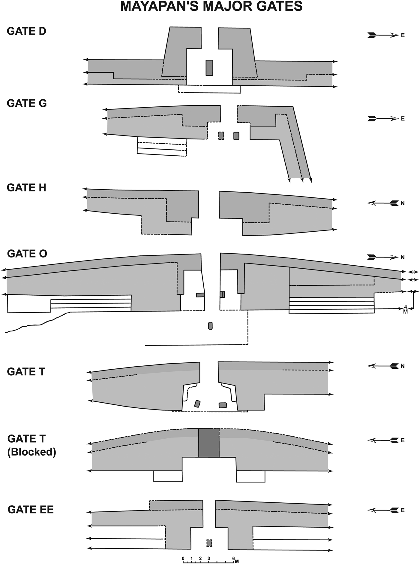
Mayapan's major gates (Figure 6) provide the most unambiguous support for the defensive function of the barrier. They vary in form to a degree but share some common features. In general, the major gates at the site show an increased wall thickness when compared to adjacent wall sections. This widening accommodates what Shook (Reference Shook1952) called a “portico,” a small chamber that built into the inner side of the wall. The entrance to the portico is a narrow gap between one and two meters wide. As noted above within the portico were placed pillars, many monolithic, to direct movement and possibly support a perishable roof. Shook's excavations yielded no evidence of fallen masonry roofing. These pillars are typically shorter than the columns supporting roof beams in much of the other architecture at the site, making them less suitable as roof supports. I suggest the pillar-baffled gate as a general form. In two cases pillars were not found, but, are suspected to have once existed based on other similarities to gates where they remain.
Diagrams of all seven major gates in the Mayapan wall. Redrawn from Shook (1962:Figures 1d–1f, 2a–2c, and 3d).
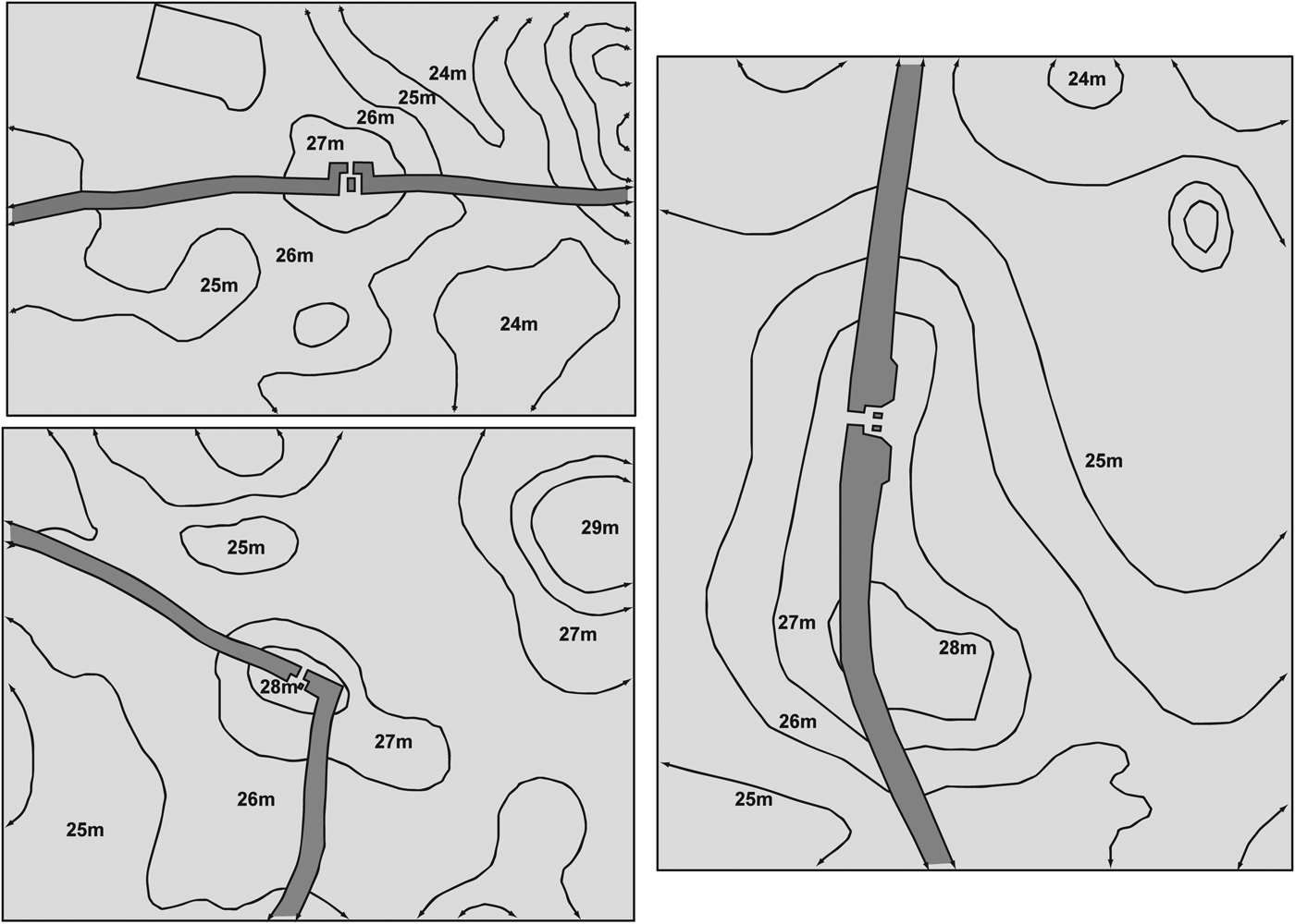
Gate D is located roughly in the center of the north portion of the wall. The gate takes the form of an outward projecting chambered or barbican style gate, the same type of gate referred to above in the quote from Díaz del Castillo (Figure 6). The authors note that barbican gates are usually main gates for the city as their straight passageways facilitate maximum movement of peacetime traffic. Placed at the center of the gate is a single large pillar that forces incoming traffic to divert to the right or left to enter. In this case the pillar is made of stacked stone slabs. In other cases, a single large monolith does the job. Either or both entrances in this gate could easily have been blocked off providing a second point that would have to be breached to storm the enclosure. This gate is located at the top of a low limestone hill or altillo that would have offered some height advantage to defenders (Figure 7, top left) as it would slow attackers running up hill and increase the range of projectile weapons. The barbican gates that Keeley and his colleagues document are straight passages. As noted, Gate D incorporates the basic element of baffling or screening in a combination not seen in the examples presented by the authors. In this case we have a pillar-baffled, barbican gate (also present are flanked gates, chambered gates and inset gates, all with pillar baffles).
Topographic maps for Gate D (top, left), Gate G (bottom, left) and Gate O (right). Redrawn from Jones' (1957) site map; showing intentional placement to take advantage of altillo elevations.
As seen in other examples, Gate G seems strategically placed atop a natural altillo, with 2–3 m of rise on approach (Figure 7, bottom left). It is located at the far northeast corner of the wall where it makes a near 90° turn from an east-west to a north-south orientation. This form is probably best described as a pillar-baffled, chambered gate since the space where the pillars were placed creates a chamber between the walls with three exits, each of which would be easy to control or monitor (Keeley et al. Reference Keeley, Fontana and Quick2007). In the case of Gate G, only one of the pillar baffles remains. A second is presumed to have existed.
Gate H also appears to be another pillar-baffled, chambered gate with the narrow entrance opening into a portico. Oddly, the placement of the portico in this gate is asymmetrical, with most of the portico placed south of the entrance. All other gates have a portico centered on the entrance. No pillars remain today. However, the form of the wall with the inward facing projections narrowing the gap at the front of the wall and widening to a portico between inner portions of the wall is quite consistent with well preserved examples like Gate T and suggests that pillar baffles were also likely present at one time. I should stress that more excavation is required to confirm these assumptions.
Gate O in the west takes the form of a pillar-baffled, flanked gate by virtue of the twin pillars used to divide traffic into three possible access routes and the flanking platforms and stairway features located on either side (Figure 6). The platforms are poorly preserved and overgrown today, like much of the wall. They were immediately recognizable in form on the ground, however. They were substantial enough to support a good number of defenders. Looking at the map published by Shook (Reference Shook1952), it appears that this gate may once have had an inset form and the platforms added somewhat later. This gate is placed atop a long linear-shaped altillo rising approximately 3 m to the level of the gate (Figure 7, right). The drop-off is unusually abrupt for the area's terrain. When we surveyed the area, we recorded a wedge-shaped ramp constructed with stacked flat limestone slabs just beyond the limits of the Jones (Reference Jones1957) map that was designated Ramp O (Russell Reference Russell2008:720–723). It starts near the base of this drop-off and reduced the incline of the approach. Oddly, this feature was not noted by Shook who undertook his most extensive investigations at this gate. While it makes the walk up easier for peacetime traffic, it also narrows the approach causing attackers to bottleneck at the feature. The bedrock outcrops flanking it would have been much more difficult to scale under fire.
Two gates in the wall along Grid Square T are particularly interesting. Blocked Gate T takes the form of an inset gate as identified by (Keeley et al. 2007) by virtue of its two inward facing wall projections. Based primarily on the form, the gate probably had twin pillar baffles as seen in the nearby unblocked gate a suggested by Shook (Reference Shook1952). The nearby Gate T presents the typical entrance, portico, and pillar-baffle configuration already seen, with the addition of two low platforms in the inner corners of the portico. Each platform would be about large enough for a single person to stand on. The close spacing of the two gates in this grid square is unique at the site, suggesting that the two gates did not function simultaneously. If the second was constructed when the first was sealed, the pillars there may simply have been relocated the short distance. More research would be required to determine an exact construction sequence for the two entrances. The relationship of the two gates in Grid Square to the X-coton temple-cenote group is noteworthy. It is possible that the change in wall was simply made to manage movement of people around that group. Perhaps the blockage was associated with specific construction in the group, another question for future research.
The form of Gate EE differs somewhat from those just discussed and bares more similarity to Gate D (Figure 6). As seen in gate D, the entrance to this gate leads into a chamber that is then divided by a single pillar-baffle. However, this example lacks the outward projection that qualified Gate D as a barbican style gate. This gate also has relatively broad flanking platforms to hold defenders. I would call this a pillar-baffled flanked gate by virtue of this feature. Shook (Reference Shook1952) notes that this gate was thickened by a second stage of construction in which a second wall was build up in front of the existing barrier. This is not common at the site. He speculated that this addition may have served as added buttressing to support a sagging or crumbling wall.
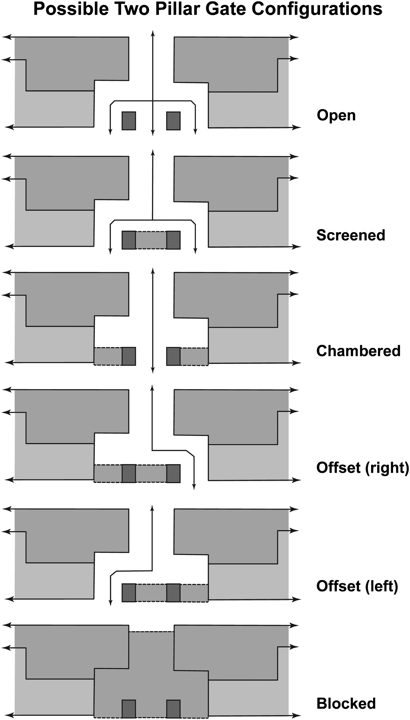
These pillar-baffled gates are interesting when compared with the examples documented by Keeley et al. (Reference Keeley, Fontana and Quick2007). Thickening of the walls at the gate and flaking platforms would have provided extra room to mass defenders. The double or triple passageway created by the pillars would have been easy to control. In peace time, leaving the center passage open would have allowed desired traffic to move directly through. In times of hostility, the configuration could rapidly be changed by blocking off sections. In this way, the gate could have been rapidly converted into a screened gate by blocking the center path or a left of right offset gate by blocking an end and the center (Figure 8). The innovative form allowed a great deal of flexibility for defenders.
Diagram of possible configurations of two-pillar baffled gates.
SECONDARY FUNCTIONS OF THE MAYAPAN ENCLOSURE
Even though many walled fortifications serve primarily as defense for settlements, they often take on additional functions that should not be overlooked. Some of these were likely intended at the time the wall was constructed, while others developed over time. I want to point to four likely secondary functions of the Mayapan wall that are suggested by my research.
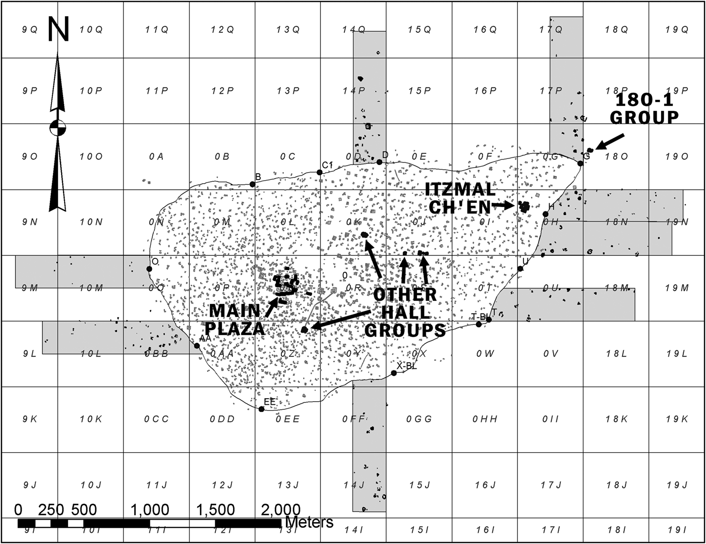
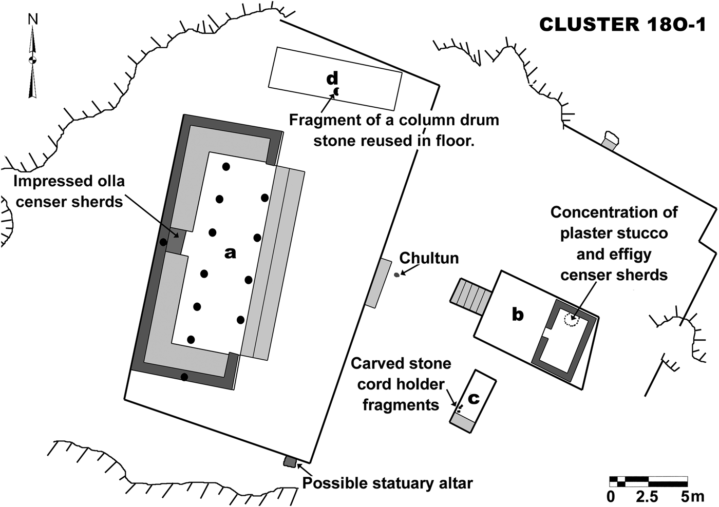
First, the wall apparently served as a means of monitoring and controlling entrance into the city. Most of the major gates have some form of chamber or “portico” that likely held officials monitoring traffic flows. The 18O-1 colonnaded hall group (Figures 9 and 10) is located just to the northeast of Gate G. Anyone entering the city along the major roadway leading in that gate would be forced to pass directly in front of the group. Immediately across the roadway from the 18O-1 colonnaded hall group Jones (Reference Jones1957) shows a large rectangular platform that may have served storage functions. I have argued previously that this group likely served as a sort of checkpoint for people and possibly goods passing into the city (Russell Reference Russell2007, Reference Russell2008:573–577). Survey work outside of the wall indicates that the bulk of crops being produced were grown in a large agricultural field area to the east of the city itself. Our project's ongoing mapping effort within the walls suggests that the roadway passing through Gate G provided a direct route of travel to two large plazas that appear to have served as central markets. This suggests that much of the agricultural goods being moved into the city for distribution through its markets would have passed through this gate. Controlling this major gate and route of travel would have allowed management of both people and goods entering into those markets and other areas of the city. The Book of Chilam Balam of Mani (cited in Roys Reference Roys, Pollock, Roys, Proskoriakoff and Smith1962:79) indicates that three of the four major directional gates of the city were controlled by different lineages residing at the site. These lineages were referred to as “guardians” of the gates and the document indicates that the east gate of the city was guarded by the “Couoh” or Kowoj lineage. Mayapan's colonnaded halls are commonly interpreted as lineage-based administrative structures. As such, it seems likely that the 18O-1 group was the location from which access to the city's east gate was controlled or “guarded.”
Map showing location of all known colonnaded hall groups including Group 18O-1, a likely control point for people and goods moving into the city through Gate G. Survey suggested that much of the agricultural goods being produced at the site came from east side field areas detected near this gate in grid squares 18N and 19N. Further survey is required to establish the full extent of this production zone.
Map of colonnaded hall group 18O-1. Jones (Reference Jones1957) recorded a large platform just to the south of this group that may have been a storage structure.
Second, it seems to have served as a kind of ritual barrier delimiting both positive and negative ritual space. As noted above, Andrews and Patton (Reference Andrews and Patton1938) pointed out that the layout of the wall did not seem to take maximum advantage of all available water sources. In particular, he noted the exclusion of “one cenote” by a mere thirty meters. It appears that he was referring to Cenote Sac Uayum in Grid Square X. I argue that the wall placement in this area was intended to separate people from this particular cenote and its related evil forces. The feature itself is the most uninviting cenotes I have seen at the site. The mouth is narrow and very dark, ringed with jagged, tooth-like, limestone stalactites on all sides. I was not able to see the bottom from the surface with the natural light of day. More importantly, this cenote has distinctively negative ritual associations to modern residents. When I visited the location with Miguel Aguilera, local informants Fernando Mena and Fernando Flores told us of the widely held belief that if a person tries to get water from the cenote, it will begin to mysteriously bubble and fill with sediment immediately making it undrinkable. This stands in sharp contrast to reporting by Brown (Reference Brown, Brady and Prufer2005) that the water in the cenote is in fact, “unusually clear.” He further noted that local informants had suggested that the cenote has a “fearful reputation,” and that some reported witnessing a feathered serpent residing at the cenote, both in the water and in the surrounding trees, and that that local children are prohibited from playing near the cenote for fear that they will be accosted by the creature. On my visit, I was told that entering the cenote was dangerous unless specific rituals were performed by a local shaman to petition permission from the forces residing there. If these ritual notions have antiquity, it would likely not have been considered a source of water but instead a dangerous, otherworld-linked location to fear and treat with respect. Conversely, in her discussion of ritual architecture at the site, Proskouriakoff (Reference Proskouriakoff, Pollock, Roys, Proskoriakoff and Smith1962:130) argued that the course of the wall at the nearby Cenote X-coton and its associated shrines (located in grid square T adjacent to two of the wall's major gates), “seems to be deliberately deflected to contain the buildings, or at least to contain the area around the cenote near which they stand.” So, the basic principle that the wall helps to define positive and negative ritual space seems supported.
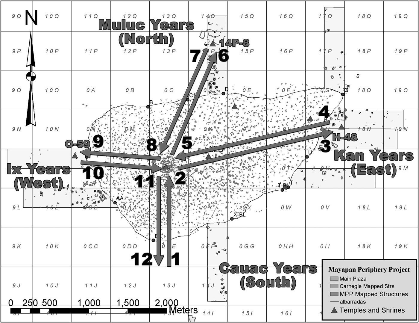
Placement of certain shrines outside of the wall may suggest similar segregation of potentially negative forces. Three shrines were located outside of the city wall (Russell Reference Russell2008:588–589, 634–641, 658–661, 837–847), one each in the east, north and west (Figure 11). The east and west side examples are located outside of the wall, along major roadways passing through Gates H and O respectively. The northern structure is slightly offline with Gate D, which can be explained by the fact that it appears to be an earlier structure originally associated with the ancient Telchaquillo settlement and then reused by residents of Mayapan in the Late Postclassic period. A fourth shine may exist in the south, thus completing a set of four shrines linked to the cardinal directions. If so, it is likely to be found south of Gate EE. Planned LiDAR mapping at the site should answer this question in the near future. It appears these structures housed idols associated with the annual Uayeb and New Year's rituals, analogous to the twin stone piles Landa observed (Tozzer Reference Tozzer1941:139–149) at the limits of Colonial period towns. I (Russell Reference Russell2000:54–55) explored the use of these idols in earlier research and found that both ethnohistoric and ethnographic evidence suggested that these idols were believed to gather negative energy throughout the year and at the end of the appointed period were disposed of in ritual dumps that were taboo with regard to further contact. Landa (cited in Tozzer Reference Tozzer1941:151–152) mentions that New Year's celebrations during the month of Pop involved the renewal of “all the objects that they made use of, such as plates, vessels, stools, mats and old clothes and the stuffs with which they wrapped up their idols.” He goes on to indicate that “and the old utensils they threw out on the waste heap outside the town; and no one, even were he in need of it, touched it.” These dumps are intentionally placed outside of cities and towns where they cannot contaminate the local surroundings or people. At Caye Coco in Northern Belize, one such dump was located segregated from the main Postclassic settlement on an island in Progresso Lagoon (Russell Reference Russell2000). It was found on the small nearby island of Caye Muerto. This suggests that Postclassic period island sites could have received ritual as well as physical protection from water barriers. Apparently the barrier was sufficient to segregate the people from the possible ill effects of close contact with the powerful forces these idols were imbued with.
Map showing hypothetical four-year cycle of New Year's idol use as described by Landa (cited in Tozzer Reference Tozzer1941) and applied to shines located around the Mayapan periphery. Idol begins at a directional shrine outside of town, moving from there to an elite house at the site center and finally to the shrine where it will be kept and venerated for the year before being disposed of in a ritual dump at the start of the next annual cycle (disposal not diagramed). Locations of three known shrines: H-48 (east), 14P-8 (north) and O-59 (west) are shown. If the theory is correct, a fourth directional shrine should exist in the south, most likely near gate EE. Future survey work should answer that question.
Third, given the site's ethnohistoric record, it appears that large portions of the city's population may have lived there against their will or under threat of force (Masson and Peraza Lope Reference Masson and Lope2014; Roys Reference Roys, Pollock, Roys, Proskoriakoff and Smith1962). So, the wall may have served as a means of controlling the movement of those living within it. In broad outline, Mayapan is described in distinctly positive and importantly peaceful terms in the early years following its founding. Later references on the other hand emphasize the heavy hand of later Cocom rulers who bring in two apparent waves of mercenaries who begin to make “slaves” of the people. To some degree this is certainly overblown in the colonial documents as many were based on accounts from descendents of the Xiu, who overthrew the Cocom resulting in the destruction of the city (including the wall itself) and its depopulation. In fact, the Xiu used this Cocom “enslavement” of the people as one rallying point for their revolt. It does suggest, however, that at the very minimum, many of Mayapan's later residents felt subjugated or otherwise discontented under the rule of the Cocom lineage and their imported mercenaries, the Canul. This enslavement may have been literal as some accounts reference the sale of local slaves to “foreign” areas. Both the capture of slaves and the taking of prisoners for sacrifice were common drivers of warfare during the period. It may also have been more figurative as demands for labor service may have increased under the later rulers, possibly to construct the massive city wall itself.
We know from ethnohistoric accounts and ongoing work at the site that as its influence grew, its size increased rapidly through the incorporation of dominated local elites and portions of their populations (Russell Reference Russell2008). Many of those were undoubtedly incorporated through force, especially late in the city's existence. This is one reason that the site is so extraordinarily dense. It is not clear how many residents moved there willingly and how many were forced. But, we do know that the feat required the application of significant mercenary muscle to accomplish. These mercenaries brought with them new weaponry, including the bow and arrow which proved very effective against local populations. As time wore on, the Xiu and other groups learned to make and use the same weapons. This provides additional support for the wall being constructed late in the site's history, when the colonial narratives suggest a shift from a relatively peaceful situation to one marked by significant warfare, both internal and external. Suppression of internal dissent then would have become an apparent priority of later rulers. Once within the walls, a resident would not have been able to leave the city without passing through one of the tightly controlled gates. There are some indications of a slave population residing in the city. But, additional excavation would be required to confirm their actual presence. Many of the mapped elite structures in particular are flanked by what appear to be much smaller residential structures that may have housed enslaved or paid, willing retainers. Even some affluent commoner groups outside of the wall near production zones have architecture suggestive of slave residences (Russell Reference Russell2008:Figures 8.72 and 8.73). North of Gate D, there are a number of unusually large group platforms lacking preserved surface architecture that were recorded during my survey. I have suggested that these may have housed groups of mercenaries or slaves living in perishable structures (Russell Reference Russell2008:777). The wall likely acted to keep disgruntled citizens and any slaves present confined to the city when and if the rulers felt it was needed—a sort of Postclassic Maya “Berlin Wall.” If correct, this interpretation would offer a plausible reason why Mayapan's rulers opted for a wall enclosing such a large number of residential structures rather than adopting the far more common tactic of only walling in selected areas of a site to serve as refuges.
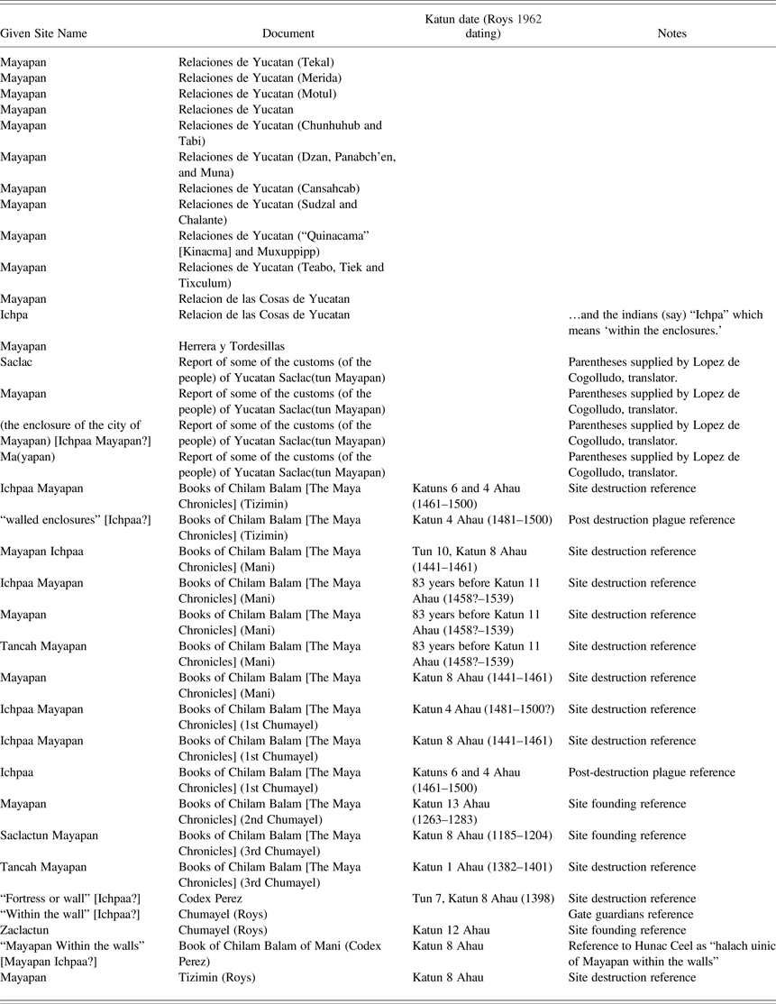
Forth, the wall apparently developed significant symbolic meaning over its use and later while it lay in ruins around the city. In fact, over time it became the dominant symbol for the entire city. The symbolic function of walled enclosures and fortifications has been well documented for many Old World sites in recent years (Alusik Reference Alusik2007; Connah Reference Connah and Tracy2001; Kemp Reference Kemp2004; Ristvet Reference Ristvet, Bretschneider, Driessen and Van Lergerght2007; Usman Reference Usman2004; Wolfe Reference Wolfe2009). The key to my argument for this New World city again lies with the ethnohistoric references to the city, especially to its name (Roys Reference Roys, Pollock, Roys, Proskoriakoff and Smith1962). The site is referred to by variants of one of four terms; Mayapan, Ichpaa, Saclactun and Tancah (Table 2). The least frequently used of these terms is “Tancah.” In the notes to his book Conquest of the Last Maya Kingdom, Jones (Reference Jones1998:430–431) indicated that Tancah can be translated as “capital” or “front town,” which suggests the city's importance as a political capital but tells us nothing of the wall. The Relaciones de Yucatan and the writings of Diego de Landa (Tozzer Reference Tozzer1941) and those copied from him by Herrera and Tordesillas (noted in Tozzer [1941]) were all based to a large degree on information gained from Xiu descendent Gaspar Antonio Chi and all prefer just Mayapan. However, Chi was clearly conversant with at least the first three terms as they all show up at some point in his accounts. It could be that Spanish speaking writers standardized his accounts to read only Mayapan. Preferring Mayapan himself, Landa (cited in Tozzer Reference Tozzer1941:19–40) also noted that “the indians (say) “Ichpa” which means ‘within the enclosures’.” Roys (Reference Roys, Pollock, Roys, Proskoriakoff and Smith1962:74) translated Ichpaa as “within the wall.” Ichpaa is used very commonly in the Maya chronicles, suggesting a significant symbolic identification of the site with its enclosing wall at least in Colonial period times and presumably earlier as these books were likely based on pre-Hispanic texts. Roys (Reference Roys, Pollock, Roys, Proskoriakoff and Smith1962:67) tells us that the term Ichpaa is “usually applied only to Mayapan in the literature.” The similarly named Ichpaatun was given that name by Gann in the 1920s (Gann Reference Gann1927:22; Roys Reference Roys, Pollock, Roys, Proskoriakoff and Smith1962:50).
Maya patronymics for the city of Mayapan (Roys Reference Roys, Pollock, Roys, Proskoriakoff and Smith1962)
Importantly, the term Ichpaa is generally used only in reference to events at the end of the site's occupation and thereafter. When the texts deal with the early days of the site and its founding, the authors typically use the Saclactun variant. Roys (Reference Roys, Pollock, Roys, Proskoriakoff and Smith1962:50) describes the term as a fusion of two Maya words, “sacal” meaning “something white” and “acantun” meaning “cavern,” which would yield something like “white cavern,” a possible reference to a cave containing water with a thin layer of white on its surface documented by Stephens (Reference Stephens1843:1:135) during his visit to the site. It also may be a reference to Cenote Itzmal Chen a prominent feature and focus of Terminal Classic period occupation at the site prior to the founding of the main site center (Russell Reference Russell2008:505). Early in the city's history it was symbolically linked with a natural feature, in this case a cave or cenote. This approach to place naming is common throughout Mesoamerica. However, unlike many sites in the region whose names are derived from natural features to this day, Mayapan's designation changed sometime near the end of the site's occupation to one that emphasized the large man-made fortifications, “Ichpaa” or “Ichpaa Mayapan.” The wall itself became the symbol of the city, closely linked to its core identity in the minds of Maya populations as far away as the Peten. The total absence of Ichpaa references in accounts of early activity at the site is striking, as is the total disappearance of the Saclactun variants by the site's fall. The late Ichpaa references also add support to the theory that the wall itself is a late construction, from the period after the arrival of Canul mercenaries who may have been more familiar with the walled fortifications of central Mexico (Armillas Reference Armillas1948, Reference Armillas1951; Silverstein Reference Silverstein2000, Reference Silverstein2001).
By combining data from a number of sources, a more complex picture emerges of the walled enclosure at Mayapan. We are able to tease out some of the important secondary functions of the structure, which have been largely missing from earlier work. We see that the wall served important peacetime functions, both political and economic. A close examination of some of the Colonial period terminology for the site suggests the massive construction took on important symbolic functions representing the city in the minds of the ancient Maya of the area. We also find ample support for defensive functions for the feature in the ethnohistory of the site and in comparison of the forms of its various gates to well-established defensive designs from around the world. While the system has functional/formal continuity with well known fortifications from many parts of the world, it represented a new and essentially unique approach to defense in the Maya lowlands. Planners designed and built an unprecedented defensive system for the city, one that reflected changing motives and methods of warfare.
SUMMARY
Ethnohistory and archaeological research from throughout the Northern lowlands suggests increasing military conflict beginning late in the Classic period and continuing through the Late Postclassic. Ethnohistoric documents strongly suggest that the local inhabitants considered Mayapan's walls defensive in nature, referring to them as among other things, a fortress. This article adds to what we already know from these sources by comparing the form of Mayapan's enclosure with cross-culturally derived and historically documented defensive features of walled enclosures, in particular the form of defendable gates. A cross-culturally derived typology of these features and their form was recently presented by Keeley et al. (Reference Keeley, Fontana and Quick2007). In this article, I apply their typology to the form of the Mayapan wall and its gates to establish, based on archaeological data, the defensive nature of the construction. The research indicates that the form of the gates in the Mayapan wall were indeed designed in a manner that permitted the strict control of movement in and out of the city and that they all incorporated design features common to other historically know defensive gate systems. Among the features documented were baffles, chambers, and flanking platforms capable of holding massed defenders. They are designed in a way that allowed them to be blocked off and modified rapidly, changing the defensive attributes of each as needed. This provides strong archaeological support to the ethnohistorically driven argument that the wall surrounding this major Postclassic center was first and foremost a defensive structure.
Furthermore, I explore four secondary functions served by the imposing construction. First, I argue that the feature would have allowed elites at the site to monitor and control the flow of people and goods into walled portion of city. This claim is based primarily on the presence of the 18O-1 colonnaded hall group located just outside of Gate G in the northeast of the site (Russell Reference Russell2007, Reference Russell2008). It is supported by the presence of chambered gate forms typically used where guards are stationed to control the flow of people through the passage. Ethnohistoric support for the claim comes from quotes in the Maya Chronicles (Roys Reference Roys, Pollock, Roys, Proskoriakoff and Smith1962) which refer to three specific lineages that served as “guardians” of specific directional gates. Second, based on the apparent snaking of the wall to exclude ritual space with negative associations (Cenote Sac Uayum) and to enclose areas with positive ritual associations (Cenote X-coton and its associated ritual architecture), I suggest that the wall served to either exclude negative supernatural forces from the city or at the minimum limit people's access to them. I buttressed this argument with three mapped examples of shrines located beyond the wall that I have argued elsewhere were associated with ritually dangerous idols and dumps (Russell Reference Russell2008:756–757). Third, I argue that the barrier served as a means to control the population housed within it. This claim is supported by frequent ethnohistoric references to the importation of foreign mercenaries used in part against the local population, slavery, internal dissent and revolts, the last of which resulted in the apparent violent destruction of the city and deliberate dismantling of the feature in the process. Finally, I build an argument that the walls served an important symbolic function to the site and to residents of the wider lowlands even years after Mayapan's fall and depopulation. To do so, I show a transition of names for the site from ones that emphasize associations with an important cave in the early occupation to terms that refer to the wall itself later in its history and after its destruction. This transition in site name over time also provides some support for the interpretation made above that the wall itself was constructed late in the history of the urban growth and development of this important Late Postclassic period political capital.
RESUMEN
La investigación etnohistórica y arqueológica en las tierras bajas norteñas sugiere un aumento en los conflictos militares durante en el período clásico, que habría continuado en el posclásico. Los documentos etnohistóricos indican que los habitantes locales consideraban las paredes de Mayapan como defensas, refiriéndose a la ciudad, entre otras formas, como una fortaleza. Este artículo agrega nuevos datos a los que ya conocemos por estas fuentes mediante la comparación de la forma del recinto de Mayapan con las características inequívocamente defensivas de recintos emparedados de culturas derivadas e históricamente documentadas. Una tipología de estas características y formas entre culturas derivadas fue presentada recientemente por Keeley y sus colegas (2007). En este artículo, aplico su tipología a la forma de la pared de Mayapan y de sus puertas; el principal objetivo es establecer, en base a datos arqueológicos, el carácter defensivo de la construcción. La investigación indica que la forma de las puertas en la pared de Mayapan fue diseñada de un modo que permitió el control definitivo del movimiento dentro y fuera de la ciudad. Todas las características del diseño incorporadas comunes a otra sepan históricamente sistemas defensivos de la puerta. Entre las principales características documentadas, se encuentran los bafles, los compartimientos, y las plataformas que flanqueaban capaces de defensores formados tenencia. Se diseñaron de una manera que permitió que fueran bloqueados y modificados rápidamente, cambiando las cualidades defensivas de cada una cuando fuese necesario. Esto da un fuerte respaldo a la discusión arqueológica apoyada en fuentes etnohistóricas que indican que el muro que rodeaba este poderoso centro de la época posclásica era principalmente una estructura defensiva.
Además de lo planteado, he explorado cuatro posibles funciones secundarias que la construcción pudo haber tenido. Primero, sostengo que sus características habrían permitido que las élites del sitio supervisaran y controlaran el flujo de gente y de mercancías en la porción amurallada de la ciudad. Esto se basa sobre todo en la presencia del grupo de columnas del pasillo 18O-1, situado apenas por fuera de la puerta G en el noreste del sitio (Russell Reference Russell2007, Reference Russell2008). Esta hipótesis es apoyada por la presencia de formas en la puerta usadas típicamente por guardianes, gente encargada de controlar el flujo de gente a través del pasillo. Los documentos etnohistóricos y lecturas de las crónicas maya hacen referencia a tres linajes específicos que fungieron como “guardas” de puertas direccionales específicas (Roys Reference Roys, Pollock, Roys, Proskoriakoff and Smith1962). En segundo lugar, en base al evidente serpenteo de la pared que excluye el espacio ritual de las asociaciones negativas (Cenote Sac Uayum) e incluye áreas con asociaciones rituales positivas (Cenote X-coton y la arquitectura ritual asociada), sugiero que la pared sirvió para excluir a fuerzas sobrenaturales negativas de la ciudad o para limitar el acceso de la gente a ellas. Rufuerzo esta discusión con tres ejemplos de las capillas situadas más allá de la pared que, en otra ocasión, he sostenido fueron asociadas a ídolos y descargas ritualmente peligrosas (Russell Reference Russell2008:756–757). En tercer lugar, sostengo que la barrera servía como un medio de controlar a la población contenida dentro de ella. Esto es apoyado por las frecuentes referencias etnohistóricas a la llegada de los mercenarios extranjeros usados en parte contra la población local, la esclavitud, la disensión y las rebeliones internas. Este último caso podría resultar en la destrucción violenta de la ciudad, por lo que hubo un deliberado intento de desmoronarlas. Finalmente, argumento que las paredes sirvieron una función simbólica importante para el sitio y sus los residentes, particularmente para los pobladores de las tierras bajas incluso después de la caída y de abandono de Mayapan. Para ello, demuestro una transición de los nombres del sitio que asocian el nombre de una cueva importante en la ocupación temprana con los términos empleados para referirse a la pared en las fases posteriores de su historia, y después de su destrucción. Esta transición en el nombre del sitio también proporciona un cierto periodo cronológico que apoya el argumento de que la pared fue construida tarde en la historia del crecimiento y desarrollo urbanos de esta última e importante capital política del posclásico.
ACKNOWLEDGMENTS
First and foremost I would like to acknowledge my wife, Megan Hansen whose love, understanding and motivation I could not imagine doing without. I would like to thank Marilyn Masson, Carlos Peraza Lope and Timothy Hare of the Proyecto Económico de Mayapan for their support and assistance throughout my process of doctoral research out of which this paper grows. It has been a true pleasure working with them over the past decade. I could not have been luckier finding myself part of the team working at this amazing site. I would also like to thank the other members of the PEMY team who have served as a sounding board for these and other ideas I have been kicking around. The final text was greatly enhanced by comments from my three reviewers, Clifford Brown, Susan Milbrath, and Jay Silverstein. The initial stages of the research that prompted this article were underwritten by grant from The Institute for Mesoamerican Studies, FAMSI and the National Science Foundation (#1018919) which was awarded to the PEMY project under the direction of Masson. All work was conducted with the permission of INAH, Yucatan. Their support of our research is greatly appreciated.