


Introduction
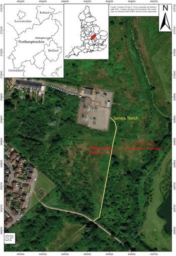
The late Iron Age and Roman site at Tannery Cottages is located to the south-east of Irthlingborough at NGR SP 946698 and lies within an area of low-lying open grassland on the western edge of the Nene valley flood plain. Quarrying for gravel to the east of the site produced evidence for Roman occupation including pitched stone foundations,Footnote 1 while the built-up edge of Irthlingborough lies to the west. The details of this location are given in Fig. 1. Interest in the site was initially stimulated by finds produced by various local metal detectorists, especially Mr Jon Grey, who undertook metal-detector sweeps of the area and produced significant numbers of Roman coins, an Iron Age coin of Tasciovanus and various copper-alloy items including harness fittings and mounts.Footnote 2 This activity led to the foundation of the Irthlingborough Archaeological Society (IAS) who continue to take an active interest in the site. Other, earlier finds dating from the Neolithic to the Roman periods were also recorded on the Northamptonshire Historic Environment Record along with late nineteenth-century industrial activity.Footnote 3 In 2014, Oxford Archaeology were commissioned by Western Power Distribution to undertake a watching brief and detailed archaeological recording, including some test pits, along the line of a power cable trench and this exposed extensive Iron Age and Roman settlement remains characterised by ditches and post-holes with the pottery indicating a date range from the middle Iron Age through until the late first century a.d.Footnote 4 These findings stimulated a geophysical survey which was carried out in 2016 and detected a dense cluster of archaeological features consistent with the findings exposed along the power cable trench and other test pits.Footnote 5 A further geophysical survey was undertaken in 2018 and showed that the underlying archaeological features appeared to extend to the south-west of the 2016 survey and were linked with features seen in the 2014 watching brief.Footnote 6
Site location.
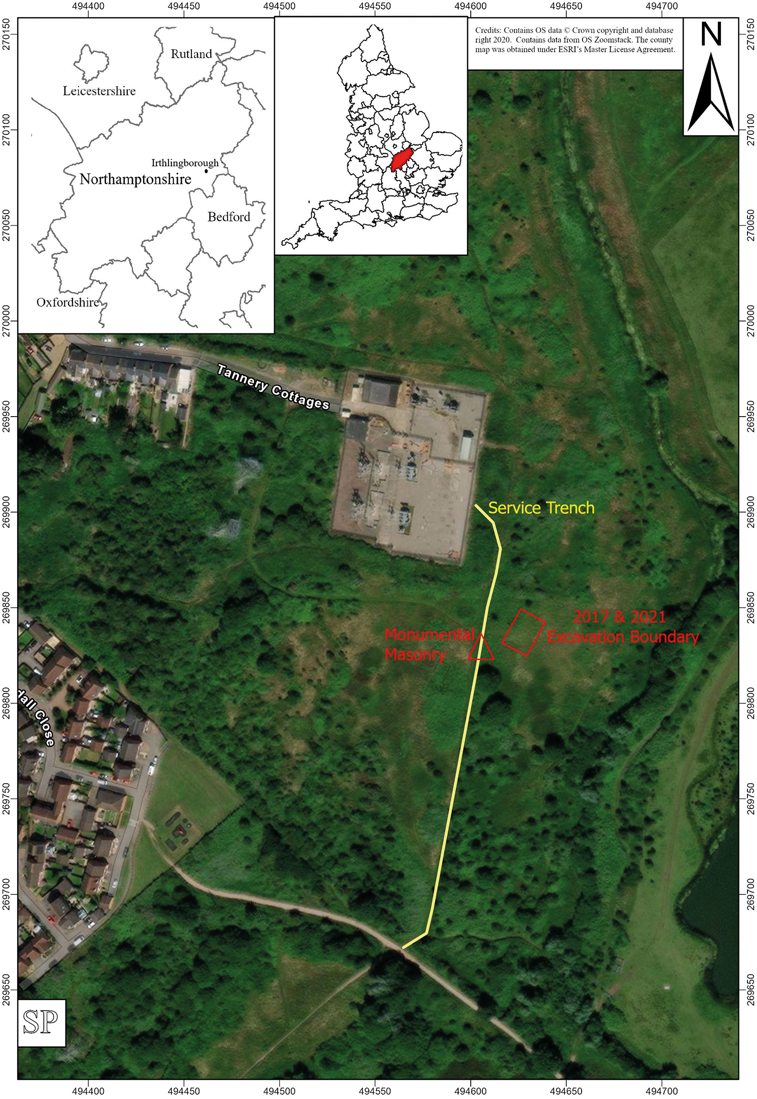
Fig. 1 Long description
A detailed map of the Tannery Cottages area in Northamptonshire, highlighting archaeological features. The main map shows a satellite view with Tannery Cottages labeled near the center. A yellow line marks the ′Service Trench′ running through the area. A red triangle labeled ′Monumental Masonry′ and a red outline labeled ′2017 & 2021 Excavation Boundary′ indicate significant archaeological sites. The inset map shows the location within Northamptonshire, bordered by Leicestershire, Rutland, Bedford and Oxfordshire. A smaller map highlights the county′s position within England. The map includes grid references and a north arrow for orientation. Surrounding areas include residential buildings and open grassland, with a focus on archaeological interest in the region.
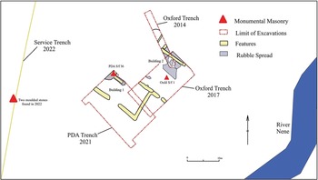
All of this interest in the area led in 2017 to the IAS undertaking a series of excavations at the site, under the guidance of Oxford Archaeology, where they opened up an excavation trench 20 m × 10 m with the twin aims of providing practical excavation and fieldwork experience for local society and community members and trying to define the archaeological features in terms of preservation, type and date.Footnote 7 This work led to the discovery of two stone-built structures which are shown in Fig. 2. Building 1, which appeared to date to the early Roman period, was partly robbed of stone but was associated with a large deposit of Roman pottery. The other building (Building 2) was better preserved and had some intact limestone slabbed flooring which was covered by later Roman demolition layers.
General site plan.
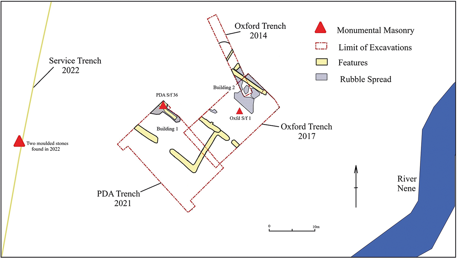
Fig. 2 Long description
Site plan detailing excavation areas near River Nene. Key elements include Service Trench 2022, PDA Trench 2021 and Oxford Trenches 2014 and 2017. Monumental masonry is marked with red triangles, including two moulded stones found in 2022. Excavation limits are outlined with dashed red lines. Yellow areas indicate features, while grey areas show rubble spread. Buildings 1 and 2 are labeled within the excavation limits. The map includes a scale bar and north arrow for orientation.
Cleaning over this building brought to light a significant piece of relief sculpture which measures 79 cm by 39 cm by 7 cm thick. The position of this fragment of stone is shown in Fig. 2 where it is marked as Oxfd S/f 1. The fragment’s thickness may have been decreased due to lamination caused by damage or a stone defect. The sides are well tooled, so it was clearly carefully prepared at the quarry site. However, the stone may then have been rejected as a final piece of sculpture due to the flaw in the block and it ended up being used as part of an area of paving, where it was recovered lying face down. Alternatively, the stone may have been used within some form of monument which was later dismantled and the stonework re-used as paving, which could have accounted for its worn and laminated state.Footnote 8
Although the relief is now very worn and the surface damaged, rendering it slightly hard to read, it evidently depicts a female figure — presumably a nereid (sea nymph) — riding upon a sea creature with a long neck and a curving body and tail, swimming towards the left.Footnote 9 The sea-creature might be a hippocamp, a seahorse, but the long neck suggests a more dragon-like creature, a ketos. The hind part of its body is well preserved and culminates in a four-pronged tail. The relief was presumably intended to be part of the marine thiasos, the retinue of followers of Oceanus, representing the realm of the sea, over which Oceanus ruled, and across which the souls of the dead must pass to the Blessed Isles.
Excavation work was also then carried out by IAS in 2021 under the direction of Derek Roberts for Pre-Develop Archaeology (PDA), which produced further archaeological features and revealed more of Building 1, encountered in 2017. The 2021 excavation trench area is shown in Fig. 2. Additionally, considerable quantities (718 sherds) of both Iron Age and Roman pottery were recovered. The Roman pottery was intriguing, as it suggested a site operating from the middle of the Iron Age, with its focus of occupation being between the late Iron Age to the early Roman period. There are no pieces within the pottery catalogue that date to after c. 225. The pottery also does not reflect a typical rural occupational assemblage from the lower or middle Nene valley. The dominance of shell-tempered fabrics and the limited repertoire and quantities of Roman forms is odd and yet the presence of first-century fineware bowls suggests a site of importance.Footnote 10
In addition to these controlled excavations outlined above, a service trench was cut in April 2022 (see Fig. 2) by Western Power Distribution close to the site without any archaeological supervision and produced Roman pottery and two fragments of moulded stone which were eventually recovered and are described below.
Two moulded stones from Tannery Cottages
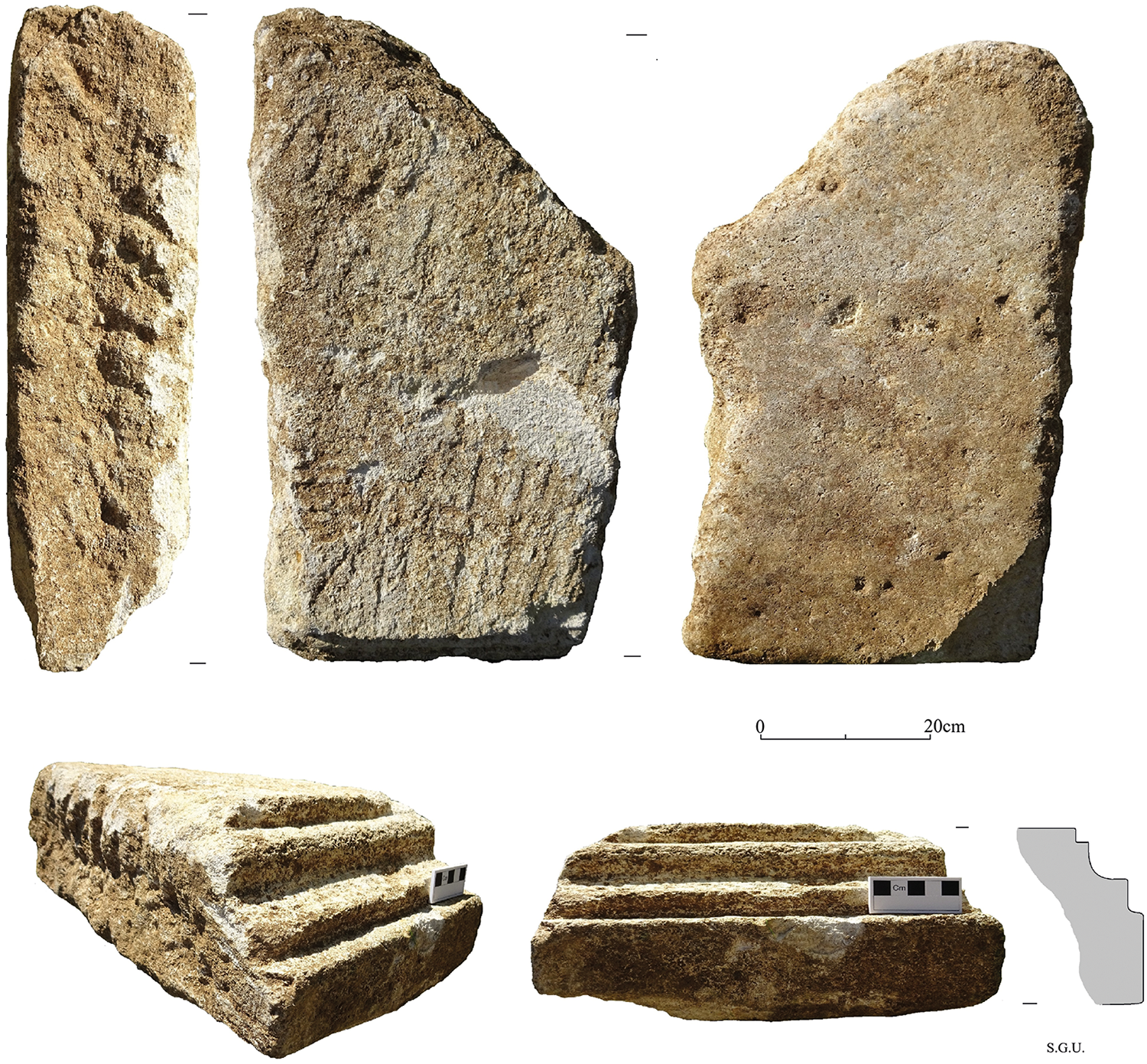
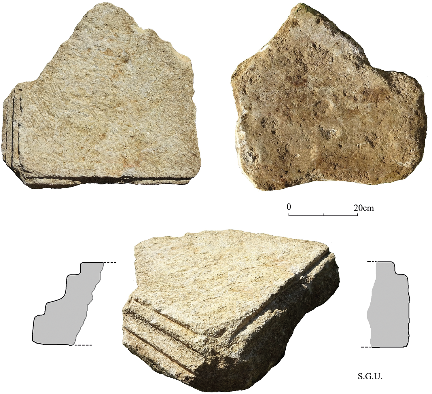
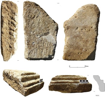
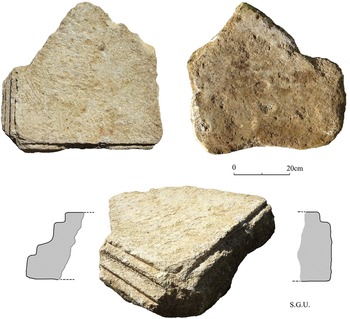
Stone 1, shown in Fig. 3 and stone 2, shown in Fig. 4 both have moulded edges, with stone 2 having moulding along two sides and which must have formed the corner of an ornate structure. The moulding on both stones consists of fillet and cavetto-and-fillet and suggests that the stones come from a large cornice or plinth. Both stones show signs of extreme wear on one side suggesting that they, too, like the sculptured stone found in 2017, had a secondary use as paving.
Details of Stone 1.
Details of Stone 2.
Stone 1, which measures approximately 43 × 78 × 23 cm, shows clear, linear marks made by mason’s tooling along its side edge with a finer set of tooling marks on the unworn, flat surface of the slab. The moulding is cut into the narrow edge of one side of this stone.
Stone 2, which measures 55 × 68 × 27cm, also shows fine tooling on its unworn, flat surface side, as on stone 1, but also shows considerable wear on the other flat side. In both cases the worn surface on the stones is such that the moulded edges would have been turned downwards to allow such wear to have formed, implying that the wear was not contemporary with the original intended use of the stones. Thus, the stones clearly had been robbed or removed from an initial structure to be reused as paving. The form and spacing of the moulding on both stones is similar, suggesting that they together formed a unified architectural piece — although the two stones do not appear to fit together.
Other architectural fragments
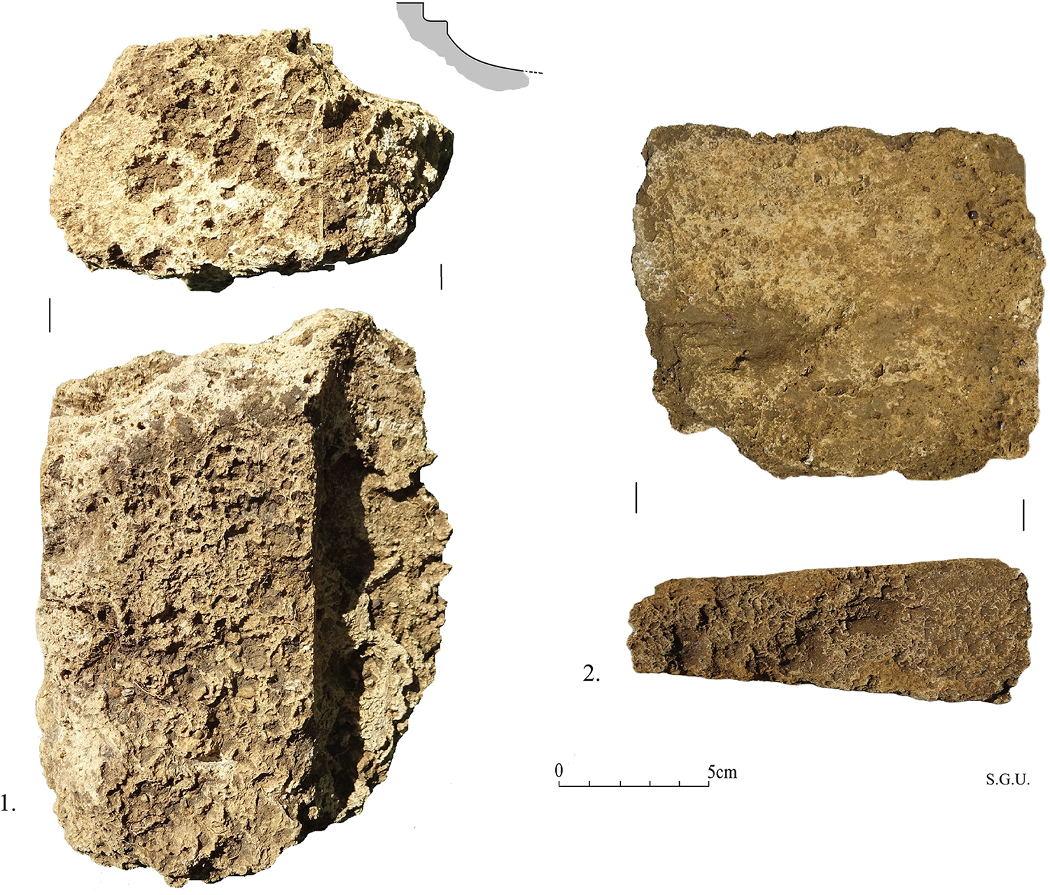
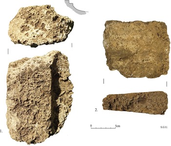
In addition to the stone fragments discussed above, there were considerable quantities of tufa, some appearing to be moulded, which were recovered from the 2021 excavations. Quantities of flue and box tile were also recovered from the same part of the site. These finds centred on the area shown in Fig. 2 and marked as PDA S/f 36. Two fragments of tufa are shown in Fig. 5 where no. 1 is a piece with fillet and cavetto moulding. Piece no. 2 appears to be a block of tufa cut to form a voussoir. There were also several other, less well-defined tufa fragments, some with indications of moulding. The tufa pieces with moulded surfaces seem to suggest that they were from an internal architectural arrangement as the material would have been too soft to resist external weather conditions, while the voussoir block would suggest vaulting.
Two fragments of tufa. Fragment 1 shows moulding to one edge and the other fragment (no. 2) is a cut voussoir block.
The two limestone blocks of stone with cut moulding appear to come from the same geological source and are probably from the same limestone quarries to the south-east of Stanwick village, which also provided much of the stone for the Stanwick villa fragments. The tufa blocks again may come from the same source as the tufa recovered from Stanwick and close to the site of the Stanwick villa.Footnote 11
Discussion
The Nene valley up until recently had yielded only limited evidence for architectural and monumental masonry from the Roman period. Early accounts and images from the nineteenth century showed both architectural elements and fragments of sculpture, but often these were chance finds and lacked a firm context for the discoveries.Footnote 12 For example, a slab from a monumental tomb which was found in 1853 appears to have come from within the walled area of the Roman town at Irchester, where it was almost certainly reused as a later grave covering.Footnote 13 Other late nineteenth-century finds from Irchester included a fragment of the torso of a statue, an octagonal fragment of sculpture and another sculptured slab with carved heads and feet. All these are listed in a useful summary of sculptural elements for Eastern England by Huskinson in 1994. This gazetteer includes 97 separate items, but excluded architectural fragments, although for Northamptonshire this aspect of monumental stonework had been summarised by Woodfield in 1978.Footnote 14 Even so, Woodfield’s gazetteer only listed 21 separate items, with a further 11 items either being lost or of uncertain date or provenance. Since the late 1970s significant other finds of architectural masonry have come to light in Northamptonshire to add considerably to this earlier listing. More stonework and sculpture has recently been recognised at the Cathedral at Peterborough, and at Bretton, 2 km from the Cathedral, monumental architectural blocks were reused as the lining for a cistern or well.Footnote 15 Structural stonework in the form of columns and moulded elements also come from a villa site at Fane Road within Greater Peterborough,Footnote 16 while the large collection from the Stanwick villa provides evidence for both domestic architecture fragments and religious or funerary monuments and is perhaps paralleled by stonework at Higham Ferrars and CorbyFootnote 17 and by a fragment of moulding, potentially from a substantial monument, from the recent excavations in the eastern suburbs of Irchester.Footnote 18
The two limestone moulded architectural fragments from Irthlingborough, along with the moulded and cut fragments of tufa and quantities of terracotta roof and heating tiles, are all interesting, but perhaps not particularly significant. However, set against the associated slab of sculptured stone from the same site and the recent published accounts of other collections of monumental masonry from nearby sites along the Nene valley, the finds raise several questions about the Irthlingborough site itself and the broader Roman landscape of villas, shrines and funerary monuments along the Nene valley.
Together the assemblage of building materials from Irthlingborough indicates a structure of some status and significance, but it is hard to extrapolate what form of construction this was. It would be easy to argue that the entire collection of monumental stonework had been brought to the site from another local area, such as Stanwick, which lies 3 km away, and that its context was that of robbed and reused material. The reuse of the stonework is clearly the case as the two stones outlined within this paper and the sculptured slab found in 2017 all show considerable signs of wear to one surface, where they were used as paving slabs. When this re-use occurred and why is at present difficult to say other than to note that a similar situation occurred with the re-use of sculptured and moulded material from Stanwick.
The key question is whether the collection of stonework at Irthlingborough represents robbed and reused material brought to the site from elsewhere or if it represents another significant structure or funeral monument on the banks of the river Nene that would have been like the structure(s) at Stanwick. At present this question is impossible to answer with certainty. At Stanwick the sculptural and architectural stonework, dated on stylistic grounds to the early third century, may have formed at least one large structure, perhaps a funerary monument, that was then dismantled and reused within parts of the fourth-century villa as rubble and building stone.Footnote 19 The dating of the monumental stonework and the site generally at Irthlingborough is, by contrast, poor. The sculptured slab has been provisionally dated to the late second or third century,Footnote 20 and there is no reason to doubt that the two moulded stone blocks from the site are of a similar date. However, the pottery assemblage at the site is curious and suggests at present that the site was declining in occupational significance by the early third century, even though the coin evidence shows some activity at the site carrying on until the fourth century.Footnote 21 On this basis one might argue that the importation of stonework from a site such as Stanwick to a site already declining in significance would have been unnecessary.
Tentative though this argument is, it is probably better at present to see the monumental stonework from Irthlingborough as representing yet another significant monument associated with whatever the large sprawl of late Iron Age and Roman occupation within the area represents — perhaps another villa and the next major villa along the Nene after Stanwick.
The geographical spacing and large size of villas along the banks of the lower Nene valley are well known,Footnote 22 and clearly this pattern continued further up the river valley well beyond Stanwick and Irthlingborough. David Neal points out the villas in this upper Nene area may also have been under some form of Imperial control, and if this were the case then the villa occupants may have been seen funerary monuments as simply adding to their status.Footnote 23 Whether such funerary monuments were meant to be viewed from the river, the local roads, or both remains uncertain.Footnote 24
What form of structure the monument at Irthlingborough took is difficult to understand, but it may have matched the funerary monument at Stanwick,Footnote 25 visible along the river-valley corridor and acting as a marker for the associated villa and its wealthy landowner. If the sculptured slab from Irthlingborough relates to the two moulded stones from the same site, then the whole structure may have been like the surviving tower tomb at Igel near Trier.Footnote 26
This aspect of the sacred, religious and funeral landscape of the Nene valley where the monumentum of sites was intended to embody the memory of significant individuals could perhaps be extended to a much wider area which is alluded to by Smith and others across a broad area of the East Midlands.Footnote 27
Acknowledgements
Particular thanks are due to Jon Grey and Andy Dycks for drawing attention to the stones and helping with their recovery from the contractor’s trenches. Western Power Distribution (now National Grid), and particularly Tobey Wing, helped and co-operated in various useful ways and provided funding for the publication of the stones. Thanks are also due to The Wildlife Trust for Bedfordshire, Cambridgeshire and Northamptonshire, particularly John Comont, Toni Castello and Pete Bray, who gave access to the land and co-operated in numerous ways during the recovery of the stones. Charlotte Walker of the HER and Ellie Cox of the PAS kindly searched records for the early finds from this site. Thanks are also due to Prof. Martin Henig FSA for reading through and making useful comments on an earlier draft of this paper, and to the anonymous reviewer who made several very useful suggestions on early finds from Irchester.

 Open access

