INTRODUCTION
The notion of neotectonic stability in central Amazonia has changed in the last decades, with increasing evidence of fault reactivation as an important control of ancient and modern Amazonian river systems (e.g., Franzinelli and Latrubesse, Reference Franzinelli and Latrubesse1993; Franzinelli et al., Reference Franzinelli, Igreja and Repolho1999; Costa et al., Reference Costa, Bemerguy, Hasui and Borges2001; Almeida-Filho and Miranda, Reference Almeida-Filho and Miranda2007; Silva et al., Reference Silva, Morales, Crósta, Costa and Jiménez-Rueda2007; Hayakawa et al., Reference Hayakawa, Rossetti and Valeriano2010; Rossetti, Reference Rossetti2014a, Reference Rossetti2014b). Nevertheless, the style and time of deformation remain to be investigated to understand the relationship with regional neotectonic events and determine the stress field in this intracratonic area of the South American plate.
Although intraplate stress has contributed to neotectonic fault reactivations in several intracratonic basins worldwide (e.g., Bosworth, Reference Bosworth2008; Braitenberg and Ebbing, Reference Braitenberg and Ebbing2009), the associated deformation mechanisms are not fully understood (Braiais et al., Reference Braiais, Guillocheau, Lasseur, Robin, Châteauneauf and Serrano2016). Intraplate neotectonics have generally been attributed to thermal subsidence during the quiescence phase following the main rifting (e.g., Maurin and Guiraud, Reference Maurin and Guiraud1993; Moulin et al., Reference Moulin, Aslanian and Unternehr2010). However, this concept has changed with the record of pervasive postrift tectonic activity in many known passive margins (e.g., Gunnel and Fleitout, Reference Gunnell and Fleitout2000; Hudec and Jackson, Reference Hudec and Jackson2002; Doré et al., Reference Doré, Lundin, Kusznir, Pascal, Johnson, Doré, Gatliff, Holdsworth, Lundin and Ritchie2008), which may affect also continental interior areas. This is also the case for the South American plate, which was affected by extensive post-Cretaceous tectonic deformation along both the plate margins to the east and the Andean chain to the west.
An E-W to ESE-WNW subhorizontal compressive stress field has been proposed to explain the style of neotectonic deformation during the postrift history of the South American plate (Riccomini and Assumpção, Reference Riccomini and Assumpção1999), which is also in accordance with general information from the World Stress Map (Heidbach et al., Reference Heidbach, Rajabi, Cui, Fuchs, Müller, Reinecker and Reiter2018). However, the stress field might vary geographically and might also change in style over geologic time. For instance, current numerical models indicate a rotation of the approximately E-W-oriented maximum horizontal compressive stress of the South America plate (e.g., Assumpção, Reference Assumpção1992) to a NW-SE-oriented maximum horizontal compression toward Brazilian Amazonia (e.g., Assumpção et al., Reference Assumpção, Dias, Zevallos and Naliboff2016), which is also in agreement with earthquakes’ focal mechanism in this region (Assumpção and Suárez, Reference Assumpção and Suárez1988). This variation in the Amazonian stress field remains to be explained, and it also needs to be clarified whether or not this was a prevalent pattern in the geologic record.
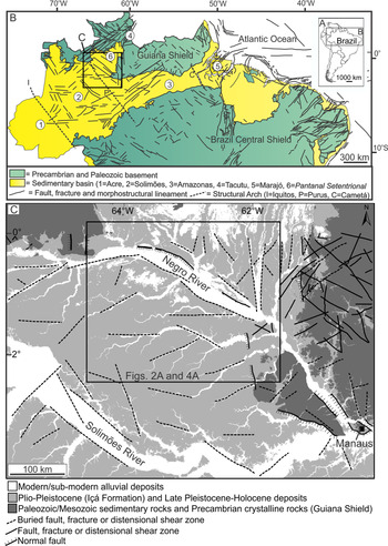
The present work has the main goal of improving the record of late Pleistocene–Holocene deformation in a large area of central Amazonia, northern Brazil, to expand the discussion about the extension of intraplate stress related to the late-stage motion of the South America plate. To address this issue, we selected an area under the influence of the Negro River valley (Fig. 1A–C), based on its location in a complex tectonic setting, where the main river parallels NW-striking morphostructural lineaments related to major strike-slip faults (Franzinelli and Latrubesse, Reference Franzinelli and Latrubesse1993; Franzinelli and Igreja, Reference Franzinelli and Igreja2002; Latrubesse and Franzinelli, Reference Latrubesse and Franzinelli2002).
(color online) Location and geologic characteristics of the study area. (A and B) Structural framework in north and northeast Brazil, with indication of main structures that intercept Precambrian shields and sedimentary basins. Also indicated are main fracture zones in the equatorial Atlantic Ocean (modified from Rossetti Reference Rossetti2014b). (C) Location of the study area (inside box) along a segment of the Negro River valley, north of central Amazonia. This figure also contains a simplified geologic map with the main lithostratigraphic units found at the surface, as well as main structural features that prevailed over the Precambrian basement and sedimentary basins in the study area and adjacency.

The present investigation was also motivated by the local finding, on the Negro River left margin, of structures unequivocally related to faults recently reactivated under a right- and left-lateral strike-slip stress regime (Rossetti et al., Reference Rossetti, Toledo and Valeriano2019). Here, we address the impact of the most recent tectonic events on the morphology of the Negro River basin, investigating the trunk valley and some tributaries that drain a vast area north of central Amazonia. Patterns of morphostructural lineaments, corresponding to alignments of drainage systems and relief morphologies, were extracted and compared with regional structural trends. Surface and subsurface magnetometric data were integrated and analyzed in the context of the regional structural framework of central Amazonia.
Using geomorphological criteria, we examined the multistory alluvial fills of the modern valley systems, as well as their frequent partition and lateral displacement as numerous, nearly orthogonal segments. We used these elements to determine the deformation timing, structural style, and stress field regime. These results contribute to the understanding of neotectonic faulting and stresses in the South American intraplate.
PHYSIOGRAPHY AND TECTONO-STRATIGRAPHIC CONTEXT
The Negro River, a main northern tributary of the Amazon River and the longest blackwater river on Earth, has headwaters in Colombia, from whence it flows 2250 km to the confluence with the Solimões–Amazon river systems. The Negro River extends up to 1370 km in the Brazilian territory, frequently changing its orientation and morphology. This river shifts its course downstream from southeast to east, and then continues southeast as far as its confluence with the Amazon River. After crossing the Precambrian rocks of the Guiana Shield, the Negro River suddenly doubles in width, forming two anomalous segments of approximately 20 km wide in its middle and lower stretches. The study area occurs in the enlarged, upper mid–Negro River valley, including areas drained by several of its tributaries to the south (Fig. 1C).
The study area is geologically located in parts of the Amazonas and Solimões basins, which were established under intraplate extension within the Amazonian Craton (Tassinari et al., Reference Tassinari, Bettencourt, Geraldes, Macambira, Lafon, Cordani, Milani, Thomaz-Filho and Campos2000). The main sedimentation in these basins was in the Paleozoic. However, renewed deposition occurred during episodes of the Andean Orogeny in the Cretaceous (Alter do Chão Formation) and, in the case of the Solimões Basin, also since the Miocene, being represented by the Solimões and Içá formations (Latrubesse et al., Reference Latrubesse, Cozzuol, Silva-Caminha, Rigsby, Absy and Jaramillo2010). Deposits mapped as Içá Formation cover most of the study area. This unit, which has a thickness of up to 80 m (Maia et al., Reference Maia, Godoy, Yamaguti, Moura and Costa1977; Reis et al., Reference Reis, Almeida, Riker and Ferreira2006), was originally related to the Plio-Pleistocene, but it also includes several sedimentary successions formed in the Pleistocene and Holocene (Rossetti et al., Reference Rossetti, Toledo and Góes2005). Although still open to debate, the northeastern sector of the study area may constitute a separate basin (i.e., the Pantanal Setentrional Basin) formed by Quaternary tectonic reactivation (Rossetti et al., Reference Rossetti, Molina and Cremon2016).
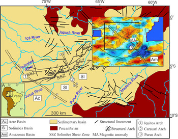
An important structure in the studied region is the Purus Arch (Fig. 1B), which is a NW-trending strike-slip fault zone formed along a middle Proterozoic graben inverted in the late Proterozoic and reactivated many times since then, at least up to the late Miocene (Wanderley Filho, Reference Wanderley Filho1991; Caputo and Soares, Reference Caputo and Soares2016). The Negro River valley in the study area follows this main structural trend, being attributed to a half-graben formed by the reactivation of faults (Franzinelli and Igreja, Reference Franzinelli and Igreja2002).
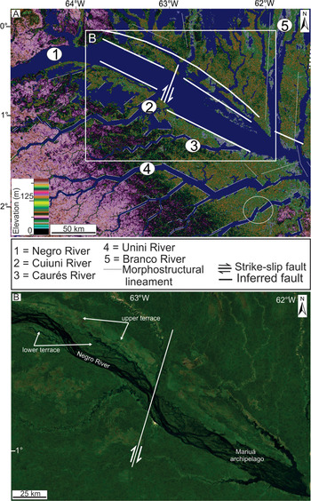
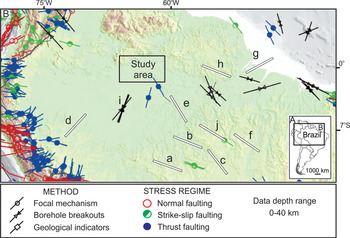
Evidence that the Negro River valley is controlled by tectonics includes numerous drainage anomalies and morphostructural lineaments (Val et al., Reference Val, Silva, Harbor, Morales, Amaral and Maia2013). An example of anomaly is the mega-capture of this river near its confluence with the Solimões River to form the Amazon River. This process also caused tributary systems on the right bank of the Negro River to reverse their flows from south to northeast (Almeida-Filho and Miranda, Reference Almeida-Filho and Miranda2007). In addition, the diverse orientations of the Negro River in the Brazilian territory parallel normal and strike-slip faults, which trend in the main NW and secondary NE, E-W (Franzinelli and Latrubesse, Reference Franzinelli and Latrubesse1993; Latrubesse and Franzinelli, Reference Latrubesse and Franzinelli2002), and N (Latrubesse and Franzinelli, Reference Latrubesse and Franzinelli2005) directions (Figs. 1C and 2A). These structures, which affect both the sedimentary basins and the adjacent Precambrian basement of the cratonic shields (Fig. 1C), parallel regional trends of other areas in the north and northeast of Brazil (Fig. 1B). Furthermore, the seismic anisotropy of the Negro River region trends on an azimuth of 120°, that is, parallel to the direction of the river and of the aeromagnetic anomalies in the area of the Guiana Shield (Rosa et al., Reference Rosa, Rosa and Fuck2014). Both geophysical directions are consistent with the regional trends of Proterozoic geologic structures. Focal mechanisms and borehole breakout data available in the World Stress Map (Heidbach et al., Reference Heidbach, Rajabi, Cui, Fuchs, Müller, Reinecker and Reiter2018) also indicate that the Amazonian region exhibits a NNW-SSE- to NNE-SSW-oriented maximum horizontal stress (Fig. 3). This region represents a different stress province from the equatorial margin and the Andes Cordillera (Assumpção, Reference Assumpção1992). Late Pleistocene and Holocene tectonic reactivations along horizontal stress fields were proposed to explain the tectonic structures recorded in different areas of central Amazonia (e.g., Rossetti, Reference Rossetti2014a, Reference Rossetti2014b), including the region of the Negro River (Val et al., Reference Val, Silva, Harbor, Morales, Amaral and Maia2013; Rossetti et al., Reference Rossetti, Toledo and Valeriano2019).
(color online) Regional morphological characteristics of the study area (see also location in Fig. 1C). (A) Main morphostructural lineaments marked on the Shuttle Radar Topography Mission digital elevation model (SRTM-DEM) background, many constituting straight segments with near-orthogonal junctions (circle indicates a place where a tributary channel was laterally displaced by a right lateral strike-slip fault); morphostructural lineaments based on Latrubesse and Franzinelli (Reference Latrubesse and Franzinelli2005). (B) The lower and upper terraces of the Negro River on a Google Earth optical image (see location in A).

(color online) (A and B) Stress fields for northern South America, with orientation of maximum horizontal compressional stress SHmax, according to the World Stress Map (cf. Heidback et al., Reference Heidbach, Rajabi, Cui, Fuchs, Müller, Reinecker and Reiter2018). Also plotted are the stress fields proposed for the Amazonian region, according to: (a–c) Barros et al. (Reference Barros, Assumpção, Quintero and Caixeta2009); (d and e) Assumpção and Suárez (Reference Assumpção and Suárez1988); (f) Assumpção et al. (Reference Assumpção, Dias, Zevallos and Naliboff2016); (g–i) Assumpção et al. (Reference Assumpção, Suarez and Veloso1985); and (j) Ciardelli and Assumpção (Reference Ciardelli and Assumpção2019).

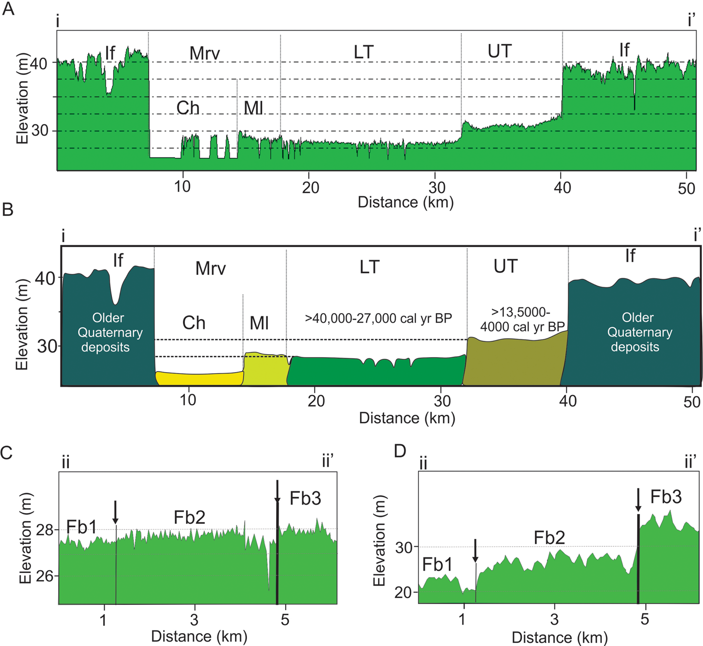
The NW-striking midcourse of the Negro River is inverted downstream from north to south, where a dextral strike-slip fault has been inferred (Latrubesse and Franzinelli, Reference Latrubesse and Franzinelli2005; Figs. 1C and 2A). Neotectonic deformation could have caused the reactivation of faults and the displacement of the midcourse of the Negro River to the southwest, a process that resulted in the development of terraces up to approximately 20 km in width on its left bank. Two terraces were recognized in this stretch of the river (Fig. 2B): a topographically high terrace (5 to 9 m) consisting of fluvial silty-clayey sands and massive clays with radiocarbon ages between >40,000 and 27,000 cal yr BP; and a lower terrace (2 to 4 m) consisting of overbank and lateral accretion clays and silts formed between 13,500 and 4000 cal yr BP (Latrubesse and Franzinelli, Reference Latrubesse and Franzinelli2005). In addition, optically stimulated luminescence ages up to 427,000 yrs BP were recorded in sedimentary deposits on the lower reaches of this river (Soares et al., Reference Soares, Tatumi and Riccomini2010).
MATERIALS AND METHODS
We used the original 3 arc-second (90 m resolution) C-band digital elevation model (DEM) acquired with the interferometric synthetic aperture radar (InSAR) during the Shuttle Radar Topography Mission (SRTM; ftp://e0srp01u.ecs.nasa.gov/srtm, accessed on September 20th, 2020). The 1 arc-second (30 m resolution) DEM of Topodata (Instituto Nacional de Pesquisas Espaciais–INPE, 2008; http://www.dsr.inpe.br/topodata/data/geotiff, access on January 11th, 2021, a full Brazilian topographic coverage database, was also used in this work. Canopy influence in the SRTM-DEM has been noted (Kellndorfer et al., Reference Kellndorfer, Pierce, Dobson, Fites, Hunsaker, Vona and Clutter2004; Walker et al., Reference Walker, Kellndorfer and Pierce2007), but data variations are generally correlated to ground relief on regional scales (Valeriano and Rossetti, Reference Valeriano and Rossetti2008, Reference Valeriano and Rossetti2017; Polidori and Simonetto, Reference Polidori and Simonetto2014). Our analysis was also improved by using the radar digital elevation model (RDEM) of the Protection System of Amazonia (SIPAM), acquired aboard the R99B shuttle mission. This radar system was operated in the L (23 cm) band, which allowed penetration into the tree canopy to provide ground surface elevations for most of the study area.
The SRTM-DEM and RDEM were processed with custom shading schemes and palettes in the Global Mapper Software (Blue Marble Geographics, Hallowell, ME, USA) to highlight sets of elevation values useful for our analysis. In addition to visual morphological analysis, the DEMs were also the basis for extracting the main morphostructural lineaments, which are straight or gently arched structural lines derived from drainage and relief elements (cf. Holmes, Reference Holmes1965; Howard, Reference Howard1967; Summerfield, Reference Summerfield1991). The morphostructural lineaments were manually vectored, considering lengths ≥2 cm on a fixed scale of 1:100,000. Lineament trends were analyzed with rose diagrams of 10° intervals, considering absolute frequencies (absolute lineament numbers) and absolute lengths (absolute lineament sizes).
In addition to SRTM-DEM and RDEM-DEM, we completed our morphological analysis using high-resolution optical images derived from the free Google Earth (http://www.google.com/earth/index.html, accessed on January 11th, 2021) and WebGLEarth (https://www.bing.com/maps, accessed on January 11th, 2021) catalogs.
The geologic significance of morphostructural lineaments was analyzed by comparison with magnetic lineaments extracted from the Earth Magnetic Anomaly Grid (EMAG2) global model (Maus et al., Reference Maus, Barckhausen, Berkenbosch, Bournas, Brozena, Childers and Dostaler2009). This model compiles magnetic data acquired from satellite, marine, and aeromagnetic surveys, calculated at an altitude of 4 km above mean sea level, with a resolution of 2 arc-minute. The grid data were resampled, and a color palette was applied to highlight the magnetic anomalies using the General Mapping Tools software (Wessel et al., Reference Wessel, Smith, Scharroo, Luis and Wobbe2013).
MORPHOSTRUCTURAL LINEAMENTS
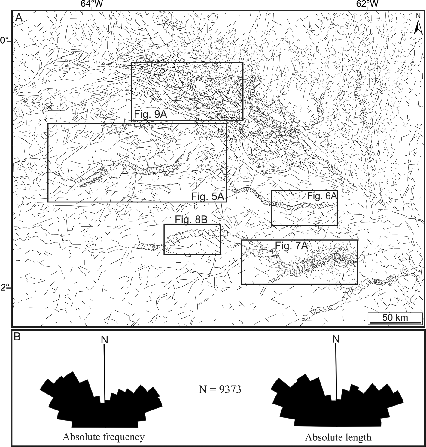
Morphostructural lineaments are abundant across the Negro River valley and its main tributary valleys, where they intercept recent alluvial sediments, as well as interfluvial deposits (Fig. 4A). The extraction of 9373 lineaments in the study area indicated a regional trend of two predominant modes: NW and NE (Fig. 4B); secondary modes trended E and N.
Morphostructural characteristics of the study area (see location in Fig. 1C). (A) Main lineaments extracted from drainage and relief elements derived from the Shuttle Radar Topography Mission digital elevation model (SRTM-DEM) and radar digital elevation model (RDEM). (B) Main structural trends of the lineaments shown in A. The five inserted rectangles indicate the locations shown in Figs. 5A, 6A, 7A, 8B, and 9A, which contain details of selected river valleys with an abundance of fractures, many attributed to strike-slip faults (see text for further explanation).

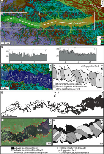
Morphostructural and sedimentary characteristics of the Caurés River valley. (A) General view of the valley in the radar digital elevation model (RDEM) background (see location in Figs. 2A and 4A), with locations of C and E and of the topographic transects shown in B. Note the various straight segments that form this river valley. (B) RDEM-based topographic profiles along the transects shown in A, with relief gradients detected across horizontally displaced floodplain blocks. (C and D) RDEM and corresponding drawing of various segmented floodplain blocks and changes in river courses along the valley stretch shown in A. (E) Main river valley along the stretch shown in A, characterized by frequent changes in course and local orthogonal junctions (circles). The rectangle indicates the location of F, where the river channels form a drainage pattern including a lake area that was progressively displaced downstream. (F and G) Detail of E, with sedimentary deposits of different stages marked by red lines in the Google Earth optical image of F and segmented blocks indicated in G. The darker and lighter gray colors in D and G highlight the set of en échelon-like segmented floodplain blocks. (For interpretation of the references to color in this figure legend, the reader is referred to the web version of this article.)

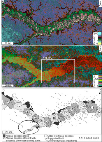
Morphostructural and sedimentary characteristics of the Unini River valley. (A and B) A stretch of the valley formed by straight segments with the orthogonal junction seen in the Shuttle Radar Topography Mission digital elevation model (SRTM-DEM) (A) and radar digital elevation model (RDEM) (B) (see location in Figs. 2A and 4A), with the boundary of the valley and morphostructural lineaments marked by red lines in the latter. (C) Drawing highlighting the morphostructural lineaments bounding segmented floodplain blocks detected in B. The darker and lighter gray colors in B highlight alternating en échelon-like blocks of stage II alluvial deposits. Ellipsoid = a set of dextrally displaced floodplain blocks in a tributary river. (For interpretation of the references to color in this figure legend, the reader is referred to the web version of this article.)Figure 8. (color online) Shuttle Radar Topography Mission digital elevation model (SRTM-DEM) with details of the faulted blocks. (A) Detail of Fig. 7B that illustrates a stretch of the Unini River valley where the meander loops change in shape along individual segmented floodplain blocks. (B) The faulted blocks (numbers) as indicated in Fig. 7C. (C) A stretch upstream of the same river shown in A, with a succession of horizontally displaced alluvial deposits (see the location in Fig. 4). The hatched lines indicate the boundaries of sedimentary deposits that fill the river valley.

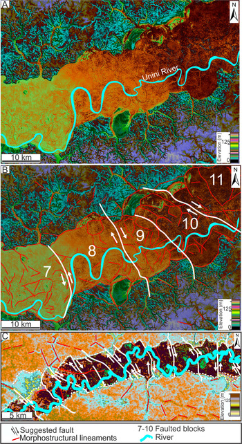
(color online) Shuttle Radar Topography Mission digital elevation model (SRTM-DEM) with details of the faulted blocks. (A) Detail of Fig. 7B that illustrates a stretch of the Unini River valley where the meander loops change in shape along individual segmented floodplain blocks. (B) The faulted blocks (numbers) as indicated in Fig. 7C. (C) A stretch upstream of the same river shown in A, with a succession of horizontally displaced alluvial deposits (see the location in Fig. 4). The hatched lines indicate the boundaries of sedimentary deposits that fill the river valley.

The most remarkable are successions of lineaments, many projecting into older interfluvial Quaternary deposits, which defined laterally displaced rectangular floodplain blocks arranged side by side in en échelon–like pattern. This configuration was particularly well illustrated in three tributaries south of the Negro River: the Cuiuni, Caurés, and Unini. It is worth noting that these river valleys contained several long segments that are inflected abruptly from NE to NW (Fig. 2A), coincident with the main regional trends.
Cuiuni River
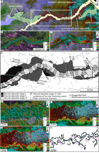
This river changed its location over time, as indicated by a paleo-valley morphology remaining on the banks of the modern valley (Fig. 5A). The modern valley exhibits a broad arched shape formed by abrupt and nearly orthogonal segments that separate the paleo-valley before the confluence with the Negro River (Fig. 5A–C). The arched stretch of the Cuiuni valley had a complex sedimentary evolution. This is evidenced by the multitemporal fill consisting of at least four stages of successively intercepting floodplain deposits (Fig. 5D), which contributed to progressively downcutting and amplifying the river valley over time. The most notable of stages I to III deposits is the constraint by many straight lineaments with orthogonal junctions (see gray dashed lines in Fig. 5D) that define rectangular to near-rectangular blocks. These are laterally displaced, with offsets up to 9 km (see gray arrows in Fig. 5D). The lineaments either end in these deposits or continue laterally into interfluvial areas and/or floodplain deposits segmented by the stage IV en échelon-like lineaments (Fig. 5D–F). The latter were arranged as a series of also laterally displaced, regularly spaced floodplain blocks (Fig. 5G). The fragmented blocks most often show the opposite sense of slip, but they may also slip in the same direction (Fig. 5D).
Morphostructural and sedimentary characteristics of the Cuiuni River valley. (A) Alluvial deposits of the ancient and present-day river valley shown on the radar digital elevation model (RDEM) background (see location in Fig. 4A). (B and C) A detail of A, illustrating the curved segment of this river in the Shuttle Radar Topography Mission digital elevation model (SRTM-DEM) (B) and RDEM (C) backgrounds, the latter containing morphostructural lineaments. (D) Enlarged view of C, with the drawing of lineaments bounding floodplain blocks that might be laterally displaced, and plot of sedimentary deposits formed in different stages of the river valley evolution. Note many laterally displaced alluvial deposits bounded by dextral NW- and sinistral NE-striking morphostructural lineaments. The latter consist of a set of successive alignments with planes orthogonal to nearly orthogonal to the main direction of the river valley. The darker and lighter gray colors indicate alternating blocks of stage IV alluvial deposits, laterally displaced and arranged following an en échelon-like pattern. See text for further explanation. (E–G) Detail of a laterally displaced segment of the valley (see location in C) seen on the SRTM-DEM (E) and RDEM (F and G) (with red traces in G highlighting morphostructural lineaments between segmented blocks). (H) Pattern of the modern drainage of the valley segment shown in E–G, with straight channels following morphostructural lineaments (see purple arrows). (For interpretation of the references to color in this figure legend, the reader is referred to the web version of this article.)

There are parallel to near-parallel morphostructural lineaments, but their direction changes progressively through the inflection areas of the river valleys. A meandering channel having meander loops with straight sides and locally orthogonal shapes is generally in continuity with lineaments within the river valleys (Fig. 5H). Most lineaments along floodplains are NW-striking and affected floodplain deposits with dextral displacement, while NE-striking lineaments are rarer and, when present, displaced floodplain deposits sinistrally (Fig 5D).
Caurés and Unini Rivers
A succession of regularly distributed, en échelon–like floodplain blocks is also present in the Caurés (Fig. 6) and Unini (Fig. 7) river valleys. In a broad view, the lower stretch of the Caurés River valley consists of several elongated rectangular segments of floodplain deposits that change direction abruptly downstream from ESE, SE, NE, E-W, and again NE (Fig. 6A). Smooth topographic gradients of a few meters marked these inflections (Fig. 6B). Individual subdivisions of this valley are composed of many orthogonal blocks of alluvial deposits with dextral lateral displacement (Fig. 6C and D). The wide valley inflections and the morphostructural lineaments that mark the displaced floodplain blocks visibly control the development of the meandering pattern of the Caurés River (Fig. 6E), as well as the orthogonal shape of a lake formed near its confluence with the Negro River (Fig. 6E and F). In this area, both lacustrine and floodplain deposits are laterally displaced mostly by NE- and NW-striking morphostructural lineaments (Fig. 6G). The Unini River valley is narrow in its lower course, but it changes abruptly upstream into an enlarged valley as wide as 20 km, formed by long and straight segments connected orthogonally (Fig. 7A). The succession of laterally displaced blocks of floodplain deposits confined to these enlarged segments follows an orthogonal to almost orthogonal distribution with respect to the valley margins (Fig. 7B and C). Most blocks are dextrally displaced by NW- and NNE-striking lineaments and sinistrally by NE-striking lineaments (Fig. 7C). As with the Cuiuni River, most blocks slip in the opposite sense, but there is a variation in which a few blocks have the same sense of slip. Dextrally displaced floodplain blocks are recorded even in some tributaries of the Unini River (see ellipsoid in Fig. 7C). As also verified in the other studied river valleys, the meander belts in the Unini River change their shapes and sizes when crossing through displaced floodplain blocks (Fig. 8A and B). It is interesting to note that, despite similar morphostructural complexity, the Unini and Caurés river valleys have simpler depositional histories than the Cuiuni River valley. This is recorded by only two stages of floodplain deposits, with deposits of the first generation (i.e., stage I) being preserved only locally along the inner banks of the valley (Figs. 6G and 7C).
Negro River
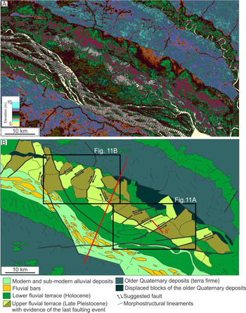
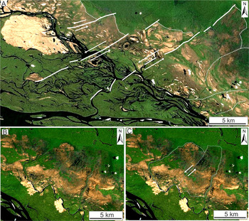
As in the tributary valleys, both terraces of the trunk river show floodplain deposits segmented by numerous lineaments (Fig. 9A and B). In the study area, the upper and lower terraces of this river stand at SRTM elevations of 5 and 2 m above the main channel, respectively (Fig. 10A and B). These elevations align with previous field observations (Latrubesse and Franzinelli, Reference Latrubesse and Franzinelli2005). The Negro River terraces are especially extensive on the north bank of the valley, where segmented floodplain blocks are pervasive. In particular, the upper terrace, dated between >40,000 and 27,000 cal yr BP in a previous publication (Latrubesse and Franzinelli, Reference Latrubesse and Franzinelli2005), contains several segmented blocks, many with lateral displacement. Although less extensive, segmentation continues in the lower terrace between 13,500 and 4000 cal yr BP, as also dated by those authors. Unlike the tributary valleys, which predominantly have blocks with dextral displacement, these terraces record mainly sinistrally displaced blocks (Figs. 9B and 11). Lateral offsets up to approximately 6 km are recorded (Fig. 11A), as well as topographic gradients from one block to another, measuring as low as <1 m on the L-band RDEM (Fig. 10C). Despite hindering accurate measurements, the canopy effect on the C-band SRTM-DEM highlighted the displaced blocks more efficiently (Fig. 10D), recording higher topographic contrasts due to additional vegetation changes on gradient conditions. Some secondary channels contour the displaced floodplain blocks to form a rectangular drainage pattern (Fig. 11B and C).
(color online) Morphostructural and sedimentary characteristics of the Negro River valley. (A) Shuttle Radar Topography Mission digital elevation model (SRTM-DEM) with the corresponding drawing (B) of a segment of the Negro River where fluvial terraces and modern alluvial deposits were extensively intercepted by morphostructural lineaments (see location in Figs. 2A and 4A). Note the increase in the number of lineaments, including laterally displaced ones, in the area corresponding to the upper terrace.

(color online) Topographic gradients along terraces of the Negro River. (A) Topographic profile and (B) corresponding geologic section illustrating the relief gradients transverse to the river valley. (C and D) Topographic profiles across a sinistrally displaced floodplain block based on data from Shuttle Radar Topography Mission digital elevation model (SRTM-DEM) (C) and radar digital elevation model (RDEM) (D). See Fig. 9B for the location of transects; Mrv, main river valley; Ch, main channel; Ml, marginal levee; LT, lower terrace; UT, upper terrace; If, interfluvial deposits; Fb1 to Fb3, displaced floodplain blocks. Ages shown in B are radiocarbon dating by Latrubesse and Franzinelli (Reference Latrubesse and Franzinelli2005).

(color online) High-resolution optical images downloaded from WebGLEarth, with details of sinistrally displaced floodplain blocks in the Negro River valley (see location in Fig. 9B). (A) A set of three parallel, NE-striking lineaments that extend from the upper into the lower terrace/modern floodplain. (B and C) Two sinistrally displaced floodplain blocks in the upper terrace (B = C, but the latter with the structures marked; arrows indicate sense of motion along segmented blocks).

Magnetic data
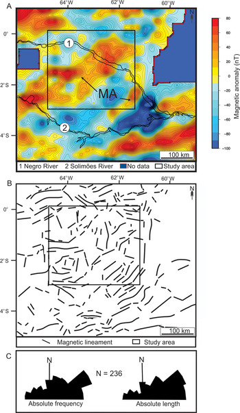
The magnetic signature derived from the EMAG2 global model (Fig. 12A) indicates that the study area in the Solimões–Negro interfluve is dominated by two parallel positive anomalies, marked by magnetic relief with moderate amplitudes ranging from 20 to 80 nT, which contrast with adjacent areas of values below 0 to −100 nT. The morphology of the main positive anomaly is composed of two rectangular shapes, notably approximately orthogonal and aligned in WNW and NE directions to the south and north, respectively. The other anomaly, located to the southeast, is much smaller and has a general NE trend.
(color online) Subsurface data of the study area and adjacency. (A) Map with magnetic anomalies (MA = magnetic anomalies described in the text). (B) Magnetic lineaments extracted from A. (C) Rose diagrams with main modes of the magnetic lineaments shown in B. The inner boxes in A and B correspond to the study area.

The shapes of the two anomalies are defined by several straight bounding lineaments. Together with several other magnetic lineaments within and external to the anomalies, these elements define a region with the structural framework characterized by a main NE trend and a subordinate NW trend (Fig. 12B).
DISCUSSION
Tectonic genesis of the morphostructural elements and deformation style
The morphological data presented herein support a tectonic control in the study area. This is suggested based on a line of evidence that includes: several long segments of tributary valleys of the Unini River, which are inflected abruptly from NE to NW, configuring orthogonal branches (Fig. 2A), added to sudden valley enlargement (Fig. 7A); the anomalously enlarged shape of the midstretch of the Negro River valley and its abrupt, nearly orthogonal downstream inflection from ENE to SE; and the lateral displacements of alluvial deposits of the Negro River terraces and also of their tributaries, the latter configuring successions of en échelon blocks, which we relate to faults. These features are similar to morphological anomalies commonly used to infer tectonic forcing in many other fluvial landforms on Earth (e.g., Miccadei et al., Reference Miccadei, Paron and Piacentini2004; Jordan et al., Reference Jordan, Meijninger, van Hinsbergen, Meulenkamp and van Dijk2005; D'Alessandro et al., Reference D'Alessandro, Miccadei and Piacentini2008; Della Seta et al., Reference Della Seta, Monte, Fredi, Miccadei, Nesci, Pambianchi, Piacentini and Troiani2008 and references therein; Enrico and Tommaso, Reference Enrico, Tommaso and Schattner2011; Jelínek et al., Reference Jelínek, Stanek, Thomas, Danek and Malis2013; Sedrette et al., Reference Sedrette, Rebai and Mastere2016).
The NE- and NW-striking morphostructural lineaments paralleling the main regional structural trends of central Amazonia (e.g., Costa et al., Reference Costa, Bemerguy, Hasui and Borges2001; Silva et al., Reference Silva, Morales, Crósta, Costa and Jiménez-Rueda2007; Serviço Geológico do Brasil–CPRM, 2010) further support a relationship to tectonic structures. Especially, the NW-trending lineaments parallel normal and strike-slip faults that define the main course of the Negro River in the Brazilian territory (Bezerra, Reference Bezerra2003; Franzinelli and Latrubesse, Reference Franzinelli and Latrubesse1993; Latrubesse and Franzinelli, Reference Latrubesse and Franzinelli2002, Reference Latrubesse and Franzinelli2005; Rossetti Reference Rossetti2014a, Reference Rossetti2014b). It is interesting to recollect that this is also the trend of the strike-slip fault zone along the Purus Arch, located a few kilometers south of the Negro River valley (Fig. 13). Thus, the most likely explanation is that the NW-trending morphostructural lineaments and the half-graben of the Negro River are the result of reactivation of pre-existing structures of the Purus Arch.
(color online) Magnetic map overlapped on a simplified geologic map to show the continuity of NE-trending anomalies with the Solimões Shear Zone. The box inserted in the magnetic map locates the study area.

The NE-trending lineaments are also related to the reactivation of pre-existing structures, as these relief elements align in the same direction of main subsurface lineaments that bound the elongated sides of the rectangular-shaped magnetic anomalies. Information evidencing that these anomalies record subsurface structures is their physical continuity with the NE-trending Solimões Shear Zone that dominates the tectonic framework in the central Solimões Basin (Fig. 13). Therefore, the NE-trending morphostructural lineaments of the study area are attributed to the surface expression of deep strike-slip faults belonging to the Solimões Shear Zone. On the other hand, the NW-trending magnetic lineaments are consistent with the reactivation of NW-striking faults along the Purus Arch (see number 3 in Fig. 13), as indicated by the surface morphostructural data.
The correspondence of the NW- and NE-trending morphostructural lineaments with both the strike-slip faults of the Negro River half-graben and the deep-seated strike-slip faults of the Purus and Solimões Shear Zone leads us to propose that the relief in the study area was molded by transcurrent deformation. Testing this hypothesis might be troublesome based solely on the plan view allowed by our remote-sensing data, but some morphostructural characteristics can be used to support this interpretation. Although it is well known that faults with moderate vertical motions can produce apparent horizontal offsets, we relate the pervasive lateral offsets up to ~10 km, as verified in the study area, to fault blocks that preferentially moved laterally with no significant associated topography, typical of strike-slip faults. This interpretation is also consistent with some faults with angles ranging from 30° to 60° and the same sense of slip (e.g., Figs. 5D and 7C). However, the RDEM topographic gradients of a few meters across faulted blocks suggest local dip-slip faults, common in a strike-slip stress regime. Thus, the faulted blocks with the same sense of slip may correspond to the horizontal component of locally developed normal and, as indicated by the focal mechanism data (Fig. 3), mainly reverse faults. As such, oblique faults having normal and strike-slip components must be considered in the study area.
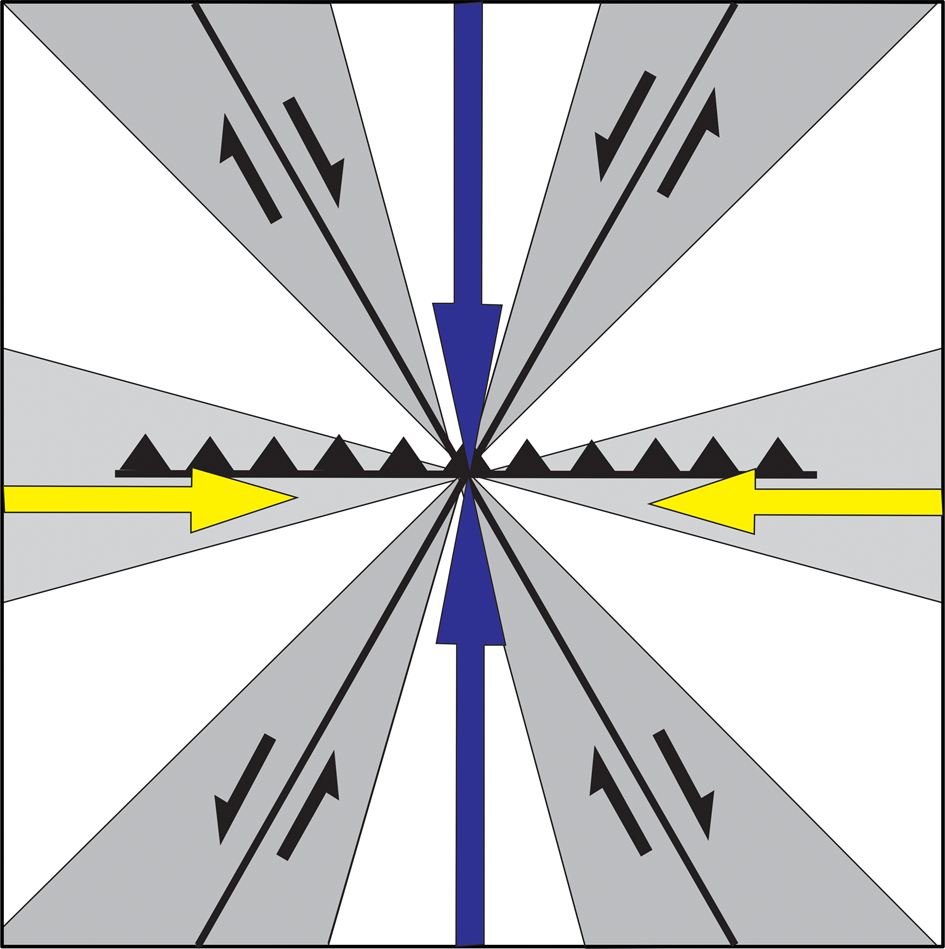
The prevalence of NW-striking dextral faults and NE-striking sinistral faults suggests strike-slip conjugate systems with a principal subhorizontal N-S-oriented compression and E-W-oriented subhorizontal extension (Fig. 14). However, the wide range of fault strikes, particularly including the series of en échelon faults that displaced floodplain deposits along river valleys, cannot be fit in a single conjugate fault system model. One possibility is that this is due to faults that are not all coeval but record the superposition of structures generated by local stress field rotations.
Regional structural schematic model with the stress fields proposed for the study area. The region is under a N-S-oriented subhorizontal maximum compression (σ1, blue arrows) and an E-W-oriented subhorizontal minimum compression (σ3, yellow arrows); the intermediate stress (σ2) is vertical. The model shows conjugate faults (black lines) consisting of dextral NW-SE strike-slip and sinistral NE-SW strike-slip faults. The gray area corresponds to the range of directions of lineaments observed in the study area. (For interpretation of the references to color in this figure legend, the reader is referred to the web version of this article.)

Another hypothesis is that the present-day stress field reactivated pre-existing weak structures not favorably oriented for reactivation under the classical Andersonian model, as already have been described elsewhere (Sibson, Reference Sibson1990, Reference Sibson1994). Considering the conjugate model, one complication is related to the intersection angle of the faults in the study area. According to the classical theoretical Coulomb fracture criterion (e.g., Freund, Reference Freund1970; Sylvester, Reference Sylvester1988), conjugate faults usually form an acute angle around 60°. This is expected under isotropic conditions, which is not the situation in the study area. The series of en échelon faults that displaced floodplain deposits were established mostly at a high angle or even orthogonally to master faults inferred by the several NE- and NW-striking segments of the Cuiuni, Caurés, and Unini distributary river valleys (Figs. 5–8). Faults that intersect at high angles, close to normal, can be explained by the reactivation of pre-existing strike-slip and/or oblique structures. Similar faults were related to the rotation of faults initially formed at a low angle from the maximum compressive stress direction (Ramsay, Reference Ramsay1980; Su et al., Reference Su, Wang, Furlong, Shi, Wang and Fan2012).
Estimating the deformation chronology
Establishing when the stress fields were reactivated in the study area is troublesome. Even though the described structures are all found on sedimentary deposits mapped mostly as Quaternary in age, one cannot fully discard the hypothesis of their inheritance from long-inactive past tectonic geometries. However, this hypothesis would require a Quaternary cover thin enough to reveal the underlying structures. Although the thickness of the studied deposits may vary from one place to another due to fluvial erosion, it would be expected that the average thickness known for this unit (80 m cf. Maia et al., Reference Maia, Godoy, Yamaguti, Moura and Costa1977; Reis et al., Reference Reis, Almeida, Riker and Ferreira2006) would have been sufficient to cover the signs of long-inactive pre-existing structures.
Therefore, a plausible explanation is that failure occurred due to the reactivation of pre-existing structures sometime in the late Pleistocene and even late Holocene, in line with our data. This proposed time for the tectonic activity is consistent with fault displacement in the deposits of the upper and lower terraces of the trunk river, with ages between >40,000 and 27,220 ± 200 yr BP and between 13,420 ± 100 and 4050 ± 50 yr BP, respectively (cf. Latrubesse and Franzinelli, Reference Latrubesse and Franzinelli2005). The fact that the upper terrace shows a higher concentration of faults relative to the lower terrace may evidence a more intense event before the formation of the lower terrace, that is, sometime before 13,000 yr BP in the late Pleistocene.
Active tectonics also displaced the alluvial deposits of many tributaries of the Negro River valleys, as indicated by: the orthogonal shape of displaced deposits, defined by straight lineaments; the continuity of many of these bounding lineaments into older interfluvial Quaternary deposits; and the successions of rectangular blocks laterally arranged in an en échelon pattern, which are related to fissures and faults that laterally displaced the latest deposits formed within the valleys.
The multistory river valley fills suggest multiple tectonic events within the late Pleistocene–Holocene, and probably also the continuity of the deformation even in the present day. In particular, the floodplain deposits displaced by faults in the Cuiuni River valley (Fig. 5) indicate at least four stages of valley fill, each resulting in fragmented, rectangular-shaped deposits that were often horizontally displaced by strike-slip faults. Although the Caurés and Unini river valleys document only two stages of floodplain deposits (Figs. 6–8), the pervasive fracturing evidenced by the sets of horizontally displaced rectangular blocks, following a pattern similar to the stage IV deposits of the Cuiuni River valley, may be related to active tectonics postdating even the last depositional event. The rectangular shape of rivers with orthogonal junctions that continues into fractures and fault planes in these tributary rivers (e.g., Figs. 5G and H and 6C) and the changes in the shape and size of meander belts when crossing individual faulted blocks (Fig. 8A and B) are additional characteristics compatible with present-day active tectonics. This interpretation is also consistent with the orthogonal shape of the lake in the lower Caurés River near the confluence with the Negro River, which follows the same pattern of strike-slip faults with dextral motion recorded upstream in this valley (Fig. 6G).
The hypothesis of present-day or near-present-day active tectonics in central Amazonia is compatible with: (1) the local but intense compartmentalization of forest habitats and pervasive tree mortality only a few tens of centuries ago in a wetland confined to a tectonic depression (Rossetti et al. (Reference Rossetti, Toledo and Valeriano2019); (2) the tectonic subsidence <2000 cal yr BP of an area of the central Viruá megafan (Rossetti et al., Reference Rossetti, Valeriano, Gribel, Cohen, Tatumi and Yee2017b); (3) the seismite in terrace deposits at the margin of the Madeira River, dated at 1382–1341 cal yr BP and related to an earthquake of a magnitude of at least 6 on the Richter scale (Rossetti et al., Reference Rossetti, Alves and Valeriano2017a); and (4) the several records of fault reactivation controlling Amazonian river systems (e.g., Franzinelli et al., Reference Franzinelli, Igreja and Repolho1999; Bezerra, Reference Bezerra2003; Costa et al., Reference Costa, Bemerguy, Hasui and Borges2001; Latrubesse and Franzinelli, Reference Latrubesse and Franzinelli2005; Almeida-Filho and Miranda, Reference Almeida-Filho and Miranda2007; Soares, Reference Soares2007; Hayakawa et al., Reference Hayakawa, Rossetti and Valeriano2010; Val et al., Reference Val, Silva, Harbor, Morales, Amaral and Maia2013; Ibanez et al., Reference Ibanez, Riccomini and Miranda2014).
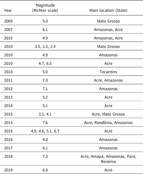
Although in situ measurements of seismological events are still scarce in Brazilian Amazonia, the available data are compatible with the proposed present-day tectonic activity. The first seismological report was made by a missionary in 1692, who described severe environmental damage (see descriptions in IHGB, 1917) close to the mouth of the Negro River, later related to an earthquake of magnitude up to 7.0 (Veloso, Reference Veloso2014) on the Richter scale. In addition, earthquakes of magnitudes 5.1 and 5.5 that affected the left bank of the Negro river in 1963 and 1983 (Assumpção et al., Reference Assumpção, Ortega, Berrocal and Veloso1983) were related to NW-striking maximum horizontal compressive stresses (Assumpção and Suárez, Reference Assumpção and Suárez1988). The seismological record in the Amazonian region has expanded in recent years (e.g., Assumpção et al., Reference Assumpção, Ferreira, Barros, Bezerra, Fraça, Barbosa, Menezes and Talwani2014); Table 1 lists the main events since 2005. Although some of these events occurred at great depths (i.e., even hundreds of kilometers), earthquake hypocenters only a few kilometers deep have also been recorded. Much further work, including breakout data and in situ measurements, is still needed to establish the causes of these Amazonian earthquakes, but a direct relationship with fault reactivation has been demonstrated in some cases (e.g., Santos et al., Reference Santos, Crisóstomo, Barbosa, Silva and Nascimento2019).
List of main earthquakes recorded in Amazonian states since 2005.

Source: https://pt.wikipedia.org/wiki/Lista_de_sismos_no_Brasil (accessed February 10, 2020).
Late-stage stress field in intraplate South America
The principal subhorizontal N-S-oriented compression and E-W-oriented horizontal extension toward the intraplate Amazonian basin distinct from the overall ~E-W pattern seen in most areas of the South American plate was already in effect since at least the late Pleistocene–Holocene. Mantle convection-driven dynamic topography has been generally indicated as a main source of intraplate stresses (Müller et al., Reference Müller, Lim and Isern2000) or hot spots (Brodie and White, Reference Brodie and White1994). This mechanism has been claimed as the source of deformation in central Amazonia in the Miocene (Shepard et al., Reference Shepard, Müller and Gurnis2010) and the middle and late Pleistocene (Val et al., Reference Val, Silva, Harbor, Morales, Amaral and Maia2013).
Mantle convection has long been known to drive plate tectonics (e.g., Holmes, Reference Holmes1931; Coltice et al., Reference Coltice, Gérault and Ulvrová2017); thus, the neotectonic stresses within the South American plate might be a result of the continued westward plate motion that caused the breakup of the Farallon plate into the Cocos and Nazca plates in the opposite side, where the latter is subducting (Tebbens and Cande, Reference Tebbens and Cande1997). It follows that central Amazonia, located in a complex intraplate region under the influence of these two stress fields, is expected to be an area of great neotectonic instability also caused by plate motion (Ojeda and Whitman, Reference Ojeda and Whitman2002; Pérez-Gussinyé et al., Reference Pérez-Gussinyé, Lowry and Watts2007).
Plate displacement since the Miocene had consequences on driving forces in the Andes and likely producing intraplate stresses (Jaillard et al., Reference Jaillard, Hérail, Monfret, Díaz–Martínez, Baby, Lavenu, Dumont, Cordani, Milani, Thomaz Filho and Campos2000; Garzione et al., Reference Garzione, Hoke, Libarkin, Withers, MacFadden, Eiler, Ghosh and Mulch2008; Assumpção et al., Reference Assumpção, Dias, Zevallos and Naliboff2016). For instance, intraplate tectonics by W-E compression in the Andes during the Pliocene–Pleistocene (Mercier et al., Reference Mercier, Sebrier, Lavenu, Cabrera, Dumont and Machare1992; Coudert et al., Reference Coudert, Frappa, Viguier and Arias1995) reactivated strike-slip faults and produced a shallow (i.e., <500-m-thick) but broad subsiding basin in central Brazil known as the Pantanal Matogrossense wetlands (Catto, Reference Catto1975). In addition, since the Miocene, episodes of Andean uplift coeval with major plate shifts caused uplift and basin inversion in northeastern Brazil (e.g., Bezerra and Vita-Finzi, Reference Bezerra and Vita-Finzi2000; Pedoja et al., Reference Pedoja, Husson, Regard, Cobbold, Ostanciaux, Johnson and Kershaw2011; Rossetti et al., Reference Rossetti, Bezerra and Dominguez2013; Gandini et al., Reference Gandini, Rossetti, Netto, Bezerra and Góes2014; Alves et al., Reference Alves, Rossetti, Valeriano and Andrades Filho2019; Bezerra et al., Reference Bezerra, Brito Neves, Correa, Barreto and Suguio2008, Reference Bezerra, Rossetti, Oliveira, Brito Neves, Medeiros, Balsamo, Nogueira, Dantas, Góes and Andrades Filho2014, Reference Bezerra, Castro, Maia, Sousa, Moura-Lima, Rossetti, Bertotti, Souza and Nogueira2020). These changes were related to the rotation from the Late Cretaceous N-S maximum compressive stress field to the E-W and, secondarily, NW-SE stress fields from the middle Miocene to the present (Bezerra et al., Reference Bezerra, Castro, Maia, Sousa, Moura-Lima, Rossetti, Bertotti, Souza and Nogueira2020).
The focal mechanism showing NE- and NW-striking strike-slip and dip-slip faults recorded in the study area during the late Pleistocene–Holocene is compatible with that prevailing regionally during the evolution of the Solimões Basin (Caputo and Soares, Reference Caputo and Soares2016). The continuity of the NE-striking faults of central Amazonia beyond the Brazilian border, for instance, into the Peruvian and Bolivian foreland basins at the boundary between the sub-Andes and the Brazilian Craton (Dumont, Reference Dumont1996), sustains a relationship with the tectonic dynamics of the South American plate, as these structures parallel the principal regional stress fields theorized for this plate.
Although the stress field in the study area might be in part attributed to the interplay of plate motion and Andean rise, the deformation style was slightly different compared with the prevailing E-W maximum horizontal stresses of areas located at the plate margin and in the sub-Andean region, as well as throughout most of western South America (Assumpção, Reference Assumpção1992; Riccomini and Asumpção, Reference Riccomini and Assumpção1999; Assumpção et al., Reference Assumpção, Dias, Zevallos and Naliboff2016; Heidbach et al., Reference Heidbach, Rajabi, Cui, Fuchs, Müller, Reinecker and Reiter2018). The variation of the present-day maximum compressive stress field from E-W to NW-SE toward central Amazonia indicated by numerical models (Fig. 3) and the late Pleistocene–Holocene principal subhorizontal N-S-oriented compression recorded in the present work lead us to argue also for the contribution of local stresses, to be determined in future investigations.
CONCLUSIONS
We conclude that the present-day relief of the study area in central Amazonia has a geologically recent tectono-sedimentary history that spans the late Pleistocene and Holocene. During this interval, fluvial valleys in the Negro River basin were filled by sediments through multiple depositional episodes. The integration of relief elements with subsurface geologic and geophysical data led us to relate NE- and NW-trending morphostructural lineaments to the reactivation of pre-existing strike-slip faults. Fault Reactivation may explain the wide range of strike directions and the high angle of intersection of the observed faults. These features may also be explained under a conjugate strike-slip regime, as suggested by the main NE- and NW-striking strike-slip faults, respectively with sinistral and dextral motions, and the oblique (normal and reverse) faults. The conjugate systems would record deformation under N-S-oriented horizontal compression and E-W-oriented horizontal extension. While the assessment of structures unequivocally related to faults has been previously documented using remote sensing, the main significance of the present work is that it is the first to record fluvial deposits with extensive faulting, including an abundance of laterally distributed strike-slip faults, over a large area of the Negro River basin. Although these episodes of tectonic deformation were in part imposed by the interplay of plate motion and Andean uplifting since the late Pleistocene, additional local factors that remain to be determined probably also contributed.
Acknowledgments
The Brazilian National Council for Scientific and Technological Development-CNPq is acknowledged for providing research fellowships to DFR and FHRB. SIPAM provided the radar RDEM. We thank the two reviewers, Frank Audemard and Siddartha Kumar Lahiri, whose comments and suggestions helped to significantly improve an early version of the article. We also wish to acknowledge the support offered by associate editor J. Urrutia Fucugauchi and senior editor Nicholas Lancaster, who provided constructive corrections and comments during the review process.