

Borders, as a topic, are more frequently discussed in geography and international relations than in archaeology, with the exception of colonial archaeology.Footnote 1 This is because borders are largely social constructs,Footnote 2 products of a crystallised social practice, and as such, they are often hard to trace in excavations. Occasionally, inscriptions, like those considered in this article, may contain detailed information from treaties between states, which enables us to reconstruct ancient borders. As Newman and Paasi have argued, borders are ‘both symbolsFootnote 3 and geopolitical manifestations of power relations and social institutions, and they become part of daily life in diverging institutional practices’.Footnote 4 This means that in a situation such as that of the treaty between Argos, Tylissos and Knossos (which will be discussed below), three possibly homologous yet unequal states,Footnote 5 the borders and the way they were enforced are representative of the regional dynamics as far as the respective states, clans, families and individuals are concerned. But that is not all; borders, whether physical or social constructs, restrict or at least affect and regulate human actions, the movements of people or goods, agriculture and pastoral economies; they forge identities and influence beliefs. In fact, this is a two-way relationship and all those things that are affected by borders also constitute what each border stands for. Boundaries, however, are not all about separation. They are rather an interface, often mediating contacts between groups, communities and individuals. Certain groups of the population, such as immigrantsFootnote 6 or pastoralists often do not perceive social and spatial boundaries in the same ways as, say, government officials do. This creates friction between groups that needs to be resolved.
As products of crystallised practice, borders create normative patterns, as MachFootnote 7 argued, regulating the interactions between social groups and their members, and setting the rules of conduct for people, goods and semiotic messages. Borders that exist for years and decades have a longer lasting effect on consciences, affiliations and patriotism. They also have an effect on the notion of a traditional homeland – even if this homeland is not included in the current borders – a sphere of influence of a sort. In short, borders are a crucial element of human interaction, reflecting in many ways the relationships between groups and their relevant identities. For all these reasons, the study of borders, whenever these borders can be traced, is of immense importance for our understanding of communication and everyday conduct in antiquity.
Two famous and roughly contemporary (on epigraphic grounds) mid-fifth-century treaty inscriptions between Argos, Tylissos and Knossos have been often closely associated. OneFootnote 8 (A) was found near the Minoan villa of Tylissos by HazzidakisFootnote 9 in one large piece and several small fragments, and the other one in two large pieces (B1 + B2) in the Argive agora.Footnote 10 These inscriptions are very important for a number of reasons and have been variously interpreted. Although I will focus here only on a few lines of the inscription (B1+ B2) which deal with borders, it is important to refer to inscription (A) and compare the two where necessary.

Inscription B

A (1–6) […] shall provide the […], and the [Kno]ssians shall have the skins. Before the Tau[rophonia<?>…], in Tylissos […]. (6–20) Neither party shall make any new treaty, save with the assent of the federal assembly, and the Argives shall cast the third part of the votes. And if we make any friend an enemy and any enemy a friend, we shall not do so, save with the assent of the federal assembly, and those from Tylissos shall cast the third part of the votes. And if a battle takes place with the other party not present, it shall be lawful to make a truce in necessity for five days. (20–3) If any army enters the land of the Knossians, the […] shall help with all their strength as far as possible. […]
(24–33— — — — —)
B (2–4) The […] may pillage (ξύλλεσθαι = σκύλλεσθαι or possibly lumber) the territories of the Acharnaeans, […] those parts which belong to the city […]. (4–11) Whatever we both together take [from the enemy<?>] shall in a division take a third of all which is taken by land, and half of everything which is taken by sea, and the Knossians shall keep the tithe of whatever we take jointly; and of the spoils both shall send the finest jointly to Delphi, and the rest both shall dedicate jointly to [… at Knoss]os. (11–14) There shall be export from Knossos to Tylissos and from Tylissos to Knossos; but if any (Tylissian) export goods beyond, he shall pay as much as the Knossians pay; and goods from Tylissos may be exported whither he [may desire]. (14–17) The [priest<?>] of the Knossians shall sacrifice to Poseidon at Iytos; both shall sacrifice jointly a cow to Hera in the HeraionFootnote 16 and they shall sacrifice before the Hyakinthia […].
(21–3) They shall keep the first day of the month at the same time [according to the decision] of both. (23–5) The Knossian may not possess real property (ἐνπιπάσκομαι = ἐγκτάομαι) at Tylissos, but the Tylissian who wishes (may do so) at Knossos. (25–9) Neither party shall cut off any of the land or take it as a whole. The boundaries of the land: Boar's Mount and the Eagles and the Artemision and the plot of Archos and the river, and through Leukoporon and Agathoia following the course of the rainwater and Laos. (29–31) When we sacrifice to Machaneus the sixty full-grown rams, to Hera too shall be given the leg of each victim. (31–4) If several cities together capture property from the enemy, as the Knossians and the Argives agree, so shall it be. (34–5) The priest of the Knossians shall sacrifice to Ares and Aphrodite, and shall receive the leg of each victim. (35–8) Archos shall keep his temenos at Acharna; the Knossians shall provide gifts to the sacrificers, and the Argives to the chorus. (38–42) If the Knossian calls for an embassy in Tylissos, it shall follow wherever he wishes, and if the Tylissian (calls the Knossian), the Knossian shall follow likewise. If they should not offer hospitality, let the Council forthwith impose a fine of ten staters on the kosmoi, and the Knossian similarly at Tylissos. (43–4) The stele was erected (ἔσστα = ἐστάθη) when Melantas was king and Lykotadas of the tribe Hylleis was in office. (44–8) Thus was the decision of the assembly for the sacred business; Archistratos of the Lykophronid phratry was president of the Council; let the Tylissians add to the stele these words: ‘if any Tylissian comes to Argos, he shall have the same rights as the Knossians’.
The characters of both inscriptions (A & B) are Argive.Footnote 17 Moreover, a recent study by Minon on the dialectal features of the two inscriptions supports the view that the Argive dialect was used in both, and was adapted in such a way so as to be easily comprehensible by the Cretans.Footnote 18 In fact the only Cretan dialectal features present in the inscriptions, which do not appear in the Argive dialect, seem predictably to be place-names. As a matter of fact, there are several dialectal features in the inscriptions that are clearly only Argive and not Cretan. This is taken by Minon to imply that in dialectal (and also diplomatic) terms, it is the Argives who wrote (or imposed) the treaties and not one of the other parties, Knossos or Tylissos.Footnote 19
Indeed, the content of the two inscriptions shows the Argives as imposing the treaty:Footnote 20 the whole treaty is a direct intervention in the affairs of Tylissos and Knossos, while there is no reference to, and thus no meddling in, the internal affairs of Argos. Argos gets a vote in favour or against any treaty made by the other two parties (A.6–17), whereas no reference is made to any votes of the Cretan cities on Argos' alliances.
The Tylissians seem to be a protectorate of ArgosFootnote 21 and gain an advantage over the Knossians: both Knossos and Tylissos seem to have rights, but Tylissos, despite being of lesser size and importance, appears to have an equal footing and in some cases seems to gain more from the treaty.Footnote 22 Indeed, inscription B2 does not allow the Knossians to have property in Tylissos, whereas it allows the Tylissians to possess what they need at Knossos (B2.23–5), thus clearly favouring the Tylissians.Footnote 23
As Merrill observes,Footnote 24 and as has been mentioned above, in the secure passage of inscription A.6–17, the Knossians and the Tylissians cannot enter into a treaty that is not approved by the Argives, and the latter have always a third of the votes. This means that the Tylissians, although a smaller city, can, in collaboration with their patrons from Argos, veto the Knossians out of an alliance or a treaty as they desire, since Tylissos and Argos control two-thirds of the votes.Footnote 25
What seems to have been the case from the above is that Tylissos is an Argive subsidiary or protectorate, in Crete. Argos wants not only to protect it from Knossian attacks or raids, but also to enhance its power in central northern Crete. A strong Argos which has already asserted or is about to assert itself in the Argive plain, thereby overrunning neighbouring competitors such as Mycenae, Tiryns and Nauplion,Footnote 26 seems to have started expanding its influence overseas in Crete. Argos, Knossos and Tylissos must have entered into a treaty after one or more incidents, diplomatic or military. This may be related to the unrest at Knossos around 476/5 BC,Footnote 27 which may have continued for some time.Footnote 28 The imposition of Argos and Tylissos, as we see in the treaty, on Knossos may have been an episode in a long period of unrest in Knossos. Argos seems to continue to dominate Knossos and Tylissos in the fourth century, as we see in the coins of the three towns (Argos, Knossos and Tylissos) which at some point towards the end of the fourth century all stamp the same Hera on some of their coins.Footnote 29 This, moreover, was not the only case of an imposition on a Cretan city (Knossos) by a mainland power (Argos), in collaboration with a minor neighbour of the Cretan city (Tylissos) in fifth-century Cretan history. Thucydides (2.85.5–6) describes the Athenians leading an expedition in 429 in alliance with the minor town of Polichni, against its superior neighbour Kydonia, ravaging the latter's countryside.
Tylissos was a much smaller city and was historically weaker than Knossos which dominated the area, much like Polychni which was weaker than Kydonia. Any effort to have Knossos and Tylissos enter a treaty as equal partners is a move in favour of Tylissos. In this light, the existence of a sovereignty protection clause in B2.25–6 becomes necessary: ‘Neither party shall cut off any of the landFootnote 30 or take it as a whole’. This clause did not seem to make any sense to the van EffenterresFootnote 31 who considered redundant the part of the treaty that would protect against the annexation of the entire territory of either city. They proposed instead that the territory protected is not the territory of either city but a third territory, an ἐσχατιά. But all such liminal (ἐσχατιά) territories should be referred to explicitly in a treaty, as we see here with the case of Achárna (B1.2–4). Besides, the relevance of the clause is duly demonstrated by history, as Tylissos seems to have fallen out of the limelight during the third or second century BC and it is not mentioned in a treaty between Eumenes II and the Cretan cities in 183 BC, or in any other later extant inscription;Footnote 32 it may have been overrun by Knossos. Conversely, an Argive and Tylissian alliance that transpires through these treaties can make actions against Knossos possible. In any case, this means that the danger of Tylissos being overrun by Knossos, and indeed of Knossos being overrun by Argos and its Cretan protectorate Tylissos, was real in the fifth century BC.
This clause was, in a way, tantamount to recognition by the Knossians mainly and the Tylissians secondarily of each other's right to exist, as well as an affirmation of the borders between the two neighbours. This recognition seems to have been imposed by ArgosFootnote 33 and clearly favours Tylissos.
I would argue here that the original reconstruction as supported by VollgraffFootnote 34 and others was the correct one: the phrase ὀροι τᾱς γᾱς in B2.26 refers to borders significant to the two territories, very likely the border between the two states. Beyond the sovereignty-protection-clause, the van Effenterres have presented further problems to such an interpretation: according to them, if this clause defines a border between the two cities, it is curious (1) that no fixed maritime border is mentioned between them; (2) that the sacred temenos of Archós, a possible male hero for the van Effenterres, is both mentioned as a border place-name and elsewhere as located at Acharna, which, if identified with modern Archanes south of Knossos, cannot constitute a border between the two cities; and (3) the absence of any designatory place-name after τᾱς γᾱς, offering no explanation as to which territory these limits apply. I shall attempt to address these issues below.
Maritime borders
With reference to the maritime borders, the van Effenterres maintain that such borders are mentioned in other treaties as in that between Lato and Ierapytna concerning the borders of Lato,Footnote 35 and thus, should be expected here. This is not wholly true, on the following grounds:
-
(a) The borders of Lato do indeed commence at the sea, but that is not a limit of the continental shelf or proper maritime borders; rather the sea is an obvious starting point for the terrestrial borders of the city.
-
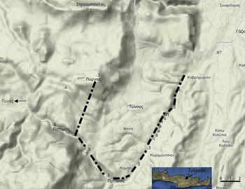
(b) It is possible that Tylissos is a land-bound state which has no sea borders, as for instance has been the modern Tylissos koinotita (see fig. 7) in the twentieth century.
-
(c) It is also arguable that the borders between Tylissos and Knossos may indeed refer to the sea, as the text includes ποταμός (river), which eventually flows to the sea.
-
(d) And finally, the sea seems to be conceived under different terms from the land as, depending on how one reconstructs the clause in B1.7,Footnote 36 the spoils are shared by only two of the cities, most likely Argos taking one half. Land-spoils on the other hand are shared by all three cities. This difference may explain the reason why the sea may have been excluded from the borders in this treaty (see b as a possibility here). In fact it may be that it is only Argos that shares the sea spoils with Knossos, since Tylissos may not have any sea interests at all.
Archós and his temenos
Archós can either be a heroFootnote 37 or an important living person in Knossos or Tylissos. In either of the two possibilities, there is nothing to prevent a reference to two different plots or two sacred plots of Archós, one at Achárna, and another in the borders of Tylissos.
There is some independent evidence, moreover, which suggests that the temenos of Archós at Achárna is unlikely to be the same as that mentioned as a border marker:
-
(a) First, the fact that there is a special qualification for the temenos of Archós (B1.36): τὀν Ἀχάρναι (the one at Acharna) suggests that Archós may have more than one plot of land.
-
(b) Second, if we follow the current reconstruction of the text in B1.2–4, we have a distinction between the land of Achárna which constitutes territory of Knossos and that which lies beyond it and is possibly open to plunder (or lumber) by the Tylissians. This reconstruction is not certain at all; what is certain is that someone is allowed to plunder (or lumber) a certain part that belongs to the Acharnians. Although the spirit of the treaty would help us reconstruct the Tylissians, it is not shrewd to speculate here. We can, however, say that Achárna could not easily be part of Tylissos since it is geographically isolated from it. If Archós was a Tylissian, we would expect him to have the right to own land at Knossos (Β2.23–5) and, therefore, the statement that he is to keep his plot would be redundant if this part of Achárna were Knossian. In other words this part of Achárna is not Knossian. Archós must be a Knossian or Tylissian individual or hero (see no. 37), who had his plot in a non-Knossian part of Acharna, for the statement to make sense.
-
(c) This would make it unlikely for the temenos at Achárna to be taken as a border at all; if the temenos was on the border it would be considered to be included in the non-controversial territory of the ‘owner’ state or of the eschatia (outlying territory) and no special provision would need to be made. It would also be unlikely for this territory to be the border between Tylissos and another place, as no matter how large Achárna territory was, it is difficult to see how it would border Tylissian territory (which is conjectured to have been fairly modest).
All the above makes it quite likely that the temenos of Archós mentioned at Achárna (B1.36) is a different one from that mentioned after the phrase ὀροι τᾱς γᾱς (B1.27).
No qualifying place-name
With respect to the van Effenterres' objections to the reconstruction of ὀροι τᾱς γᾱς as defining the borders between Knossos and Tylissos, there is one additional argument that they make: no place-name or ethnic is associated with the sentence ὀροι τᾱς γᾱς, and so it cannot be the borders of any particular state, whether Tylissos or Knossos. However, the context of the inscription makes it completely clear that we are talking about Tylissos and possibly also Knossos. It seems to me fairly obvious that any treaty which regulates the relationship between neighbouring cities should clearly state their borders; the arguments of the van Effenterres are not convincing to the contrary.
Χώρα and Γᾶ
A possible additional problem to our interpretation is the use of the terms Χώρα and Γᾶ.Footnote 38 The term Γᾶ is not frequently used in the few Cretan inscriptions referring to borders between states. Instead, they prefer the term Χώρα. Γᾶ has a variety of meanings including the earth as a deity (e.g. Hes. Theog. 20), the ‘world’ (e.g. Empedokles, fr. 46, Wright), the ‘[Greek] land’ (e.g. Eur. Hec. 1260), the ‘homeland’ (e.g. Hom. Il. 2.140), as well as ‘private land’ (Pl. Leg. 842e–843b). However, we have to remember that:
-
(a) This is not a Cretan but a fifth-century Argive inscription.
-
(b) Its approximately contemporary counterpart, found in Tylissos (also Argive in language), mentions in A.21–2: ἐνς τὰν γᾱν τὰν Κνοhίαν (in the Knossian territory), clearly using Γᾱν to mean territory (Chaniotis, pers. comm. 9/2009).
-
(c) The term Χōρα is a term best translated as campagne, often used to distinguish between the city and the countryside around it, and does not necessarily refer to the entire territory of any one state.Footnote 39 It can also mean the countryside between two cities of two states. It is, therefore, not the best term to exclusively denote ‘state territory’ in border clauses.
-
(d) Only three treaty inscriptions have attestations, either secure or contestable, of the term Χōρα in a border clause. Of these, the two securely dated are later than the middle of the second century BC.Footnote 40
-
(e) As we said above, Γᾱ may mean ‘homeland’ or ‘state territory’, if not qualified otherwise. In Euripides' Troades Footnote 41 we have the same formula as in our inscription (374–6):
ἐπεὶ δ’ ἐπ’ ἀκτὰς ἤλυθον Σκαμανδρίους,ἔθνῃσκον, οὐ γῆς ὅρι’ ἀποστερούμενοιοὐδ ὑψίπυργον πατρίδα.
In this sentence γῆ refers to the land of the entire country and not the private land of any individual.Footnote 42 Moreover, the Attic inscription IG II2 1028.22 also clearly refers to state territory:
ἐξῆλθον δὲ καὶ ἐπὶ τὰ φρούρια καὶ τὰ ὅρια γῆς Ἀττικῆς πλεονάκις ἐν ὅπλοις καθὼς ἐπέταττον αὐτοῖς τὰ ψηφίσματα τῆς τε βουλῆς καὶ τοῦ δήμου.
If such a meaning is possible for Γᾶ, it means that the word is well suited for a border clause referring to the entire territory of a state.
Taking all the above into account, it would seem most plausible therefore that the borders mentioned are indeed defining what is crucial for this treaty, in other words, the relationship between Tylissos and Knossos, attempting to bring the former to the same level as, and also protecting it from, the latter.
Placing the names
The place-names mentioned after the phrase ὀροι τᾱς γᾱς are not only illuminating in their own right, but also confirm our views on the border clause: hυōν ὄρος (the mountain/ peak of pigs/ wild boarFootnote 43 ), καὶ Αἰετοί (and Eagles) κἀρταμίτιον Footnote 44 (and the sanctuary of Artemis – Artemision) καὶ τὸ τō Ἀρχō τέμενος (and the plot of Archós) κα[ὶ] hο ποταμός (and the river) κἐλ Λευκόπορον (and through Leukoporon – meaning the ‘white passage’ possibly of the river following the thalweg, the watercourse, into white rocks or soils) κἀγάθοια (and Agathoia)Footnote 45 hᾱι hύδορ ῥεῑ τὄμβριον (as the rainwater flows), καὶ Λᾱος (and Laos, possibly ‘the Rock’). Several observations have to be made regarding this list of names. Most importantly, whenever it is possible to determine the altitude of the first seven places designated by the above names, it seems that they follow a descending order:
-
(a) hυōν ὄρος is either a mountain or its peak.
-
(b) Αἰετοί must also be at some considerable altitude as eagles always nest in high cliffs in Crete (Mylonas, pers. comm. 2010).
-
(c) The sanctuary of Artemis, as the van Effenterres argue, may be at some, perhaps intermediate or high, altitude.Footnote 46
-
(d) The van Effenterres also consider the plot of Archós to be at some height, but that is only due to the fact that they consider the plot (τέμενος) a sacred one and want Archós to be a hero, which we cannot suppose a priori.
-
(e) ποταμός (a thalweg – the line marking the watercourse) is certainly lower in altitude than most preceding named places.
-
(f) ἐλ Λευκόπορον must be one of the possible routes of the river flowing towards the sea (figures 1 and 3), and as we continue along the river-route it is bound to be lower in altitude.
-
(g) ἀγάθοια or Ἀγάθοια is certainly lower than Λευκόπορον, as we saw in note 45 and as confirmed by phrase hᾱι hύδορ ῥεῑ τὂμβριον – as the rainwater flows.Footnote 47 This phrase refers to at least ἀγάθοια and may refer to a number of place-names before it.
-
(h) Λᾱος, possibly meaning ‘the Rock’, is mentioned after this phrase and is thus not affected by it; therefore, it does not need to be lower in altitude. As Vollgraff mentions (1910, 339), another place called Λᾶος was colonised by the inhabitants of Sybaris on the Tyrrhenian coast (Herod. 6.21; Strab. 6.253). It is conceivable, therefore, that this Λᾱος is also on the coast.
-
(i) Whenever we are able to guess the altitude of the first seven locations we see a clear pattern whereby the higher of them are named first and the lower later. This suggests that the formula hᾱι hύδορ ῥεῑ τὂμβριον may refer to a number of locations in the list and not just to the immediately preceding name.
Leukoporon is reconstructed here, following interviews with the locals.

If this is the case, this would mean that most places, starting from a peak of a mountain (hυōν ὂρος) and going down to the river (ποταμός) are in the same great mountain-mass, and some are in a roughly descending order. Furthermore, this mountain-mass should be large and important enough to accommodate so many important places, plots, eagles and sanctuaries. Moreover, Λευκόπορον and ἀγάθοια should also be in the course of the same river, ποταμὸς, which may have a pretty long course. In other words we are dealing with a large mountain-mass and a possibly long river.
The presence of the river (ποταμός) is helpful in identifying the location of the border. All rivers in central northern Crete run from the south to the north; the ones in the area of Tylissos come from its west, flowing down from Mt Ida and continue northwards.
This large mountain-mass and the river would have to be natural boundaries in the area of Tylissos: no border to the east of Knossos would make sense in a treaty between Argos, Tylissos and Knossos. If we consider Youkhtas/Juktas as the summit described in this inscription, we would then have to assume that the ‘river’ is Keratos which flows past the mountain and northwards, passing next to the palace and towards the sea. This would mean that the line would cut the city of Knossos, and would not be useful as a boundary or anything else described in the treaty for that matter. A southern border running east to west is also impossible for any ‘river’ in the area; and, finally, so is a border starting with a mountain in the north coast and going southwards, since this would not be the route of rainwater.
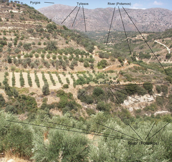
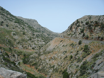
If this is the case, the fact that the river (ποταμός) is a generic name may give us a clue: if we were to choose the one river in the general area of Tylissos, there is only one candidate, a formidable natural boundary, the seasonal river flowing through the strategically important Goniano Faraggi (Gonies Gorge, from Sklavokampos to Ayia Anna).Footnote 48 This river-course is today also called by the same generic name Ποταμός. There the river flows through the plain of Gonies (and Sklavokampos), through the gorge and then through the plain to the east of Tylissos and northwards to the sea (see figure 2). There are only two mountain masses near Tylissos, on either side of the Gonies Gorge. The mountain to the south of the Gorge (Ρουσές) is irrelevant as a border since the inscription refers to the river as a boundary point (or number of points).Footnote 49 Pyrgos, the large mountain that dominates the landscape above Tylissos and separates Tylissos from the plain of GoniesFootnote 50 and its adjacent peaks to the north are the only large and important mountain mass that could be a candidate for accommodating the named places as a plausible border: hυōν ὂρος καὶ Αἰετοί κἀρταμίτιον καὶ τὸ τō Ἀρχō τέμενος.
The strategically important Gonies Gorge with the Potamos River (courtesy N. Pantzou).

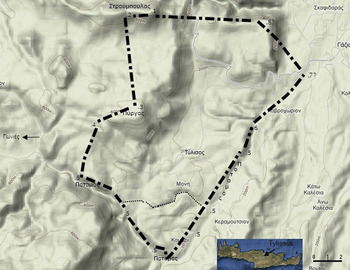
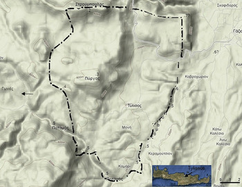
A peak such as Stroumboulas is an obvious starting point for any inland border-line around Tylissos (see figure 3) (hυōν ὂρος – peak of the pigs or wild boar).Footnote 51 Stroumboulas in particular is a very prominent peak, probably the best known peak in central north Crete. As the double peaks of Stroumboulas and Psili Loupa are located in an east–west line, the Eagles (Αἰετοί) would have been the location along this ridge where the border-line would turn south towards the other places defining Tylissian territory. Indeed, west of the peak of Timios Stavros (the eastern peak of Stroumboulas) there is a steep cliff that today is well known in the area for its eagles (Saloustros, pers. comm. September 2010).
Map showing the reconstructed borders of Tylissos: (1) hυōν ὄρος (2) Αἰετοί (3) Ἀρταμίτιον (4) τὸ τō Ἀρχō τέμενος (5) ὁ ποταμός (6) Λευκόπορον (7) ἀγάθοια (8) Λᾱος.

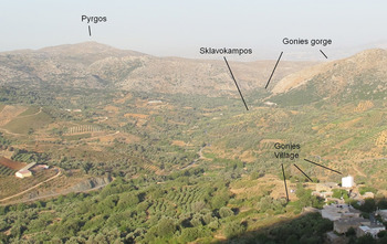
The peak of Pyrgos is a very strong candidate for the sanctuary of Artemis, since we already know that there was a sanctuary in the fourth century which reused the building of the Minoan peak sanctuary there.Footnote 52 Temples of Artemis seem to have appeared in border zones at an early stage in several areas such as Phokis and Elis from the eleventh or tenth centuries.Footnote 53 Moreover, near the peak of Pyrgos there are numerous caves, including Trapeza cave that was used in several periods, especially Old Palace and New Palace Minoan periods (Faure (Reference Faure1996) 84–6, excavated by Hazzidakis in 1913 and Faure in 1953 and 1961, not to be confused with the celebrated Trapeza in Lasithi) demonstrating its importance in antiquity.
Preliminary results of the Gonies-Philioremos project ethnographic study in 2010 reveal that the Pyrgos mountain-peak along with other peaks to its north and south act as the traditional (no longer official) border-marker between the villages of Gonies and Tylissos. The farmers and shepherds of Gonies say that the side of the mountains (including Pyrgos) they can see from Gonies belongs to them, whereas all the rest belongs to Tylissos (figure 4). This is interestingly comparable with the borders reconstructed here.
Pyrgos from the peak sanctuary of Philioremos – Gonies.

If we descend from the peak of Pyrgos down towards the river, the several alternative routes all cross the small yet prominent and naturally fortified, fertile depression (the best candidate for the temenos of Archós – since the temenos has the meaning of a demarcated plot) that nowadays belongs to the Καλλέργης family of farmers and livestock herders.Footnote 54 To reach the ποταμός from that depression, one can take at least two alternative routes that descend to either end of the gorgeFootnote 55 and then turn northwards. We then pass Tylissos on our left-hand side and continue northwards along the main river route. At some point we reach the whitish mixed ‘koúskouras’ soil that is characteristic of the Knossos area (perhaps Λευκόπορον). Indeed in a crucial (for the identification of the right course to follow) turn of the river, near the modern village of Καβροχώρι, the soil becomes distinctly white, and the nearby hill has a short white cliff next to the river. The local shepherds (Kallergis and Saloustros), when asked if in the course of the river the soils become white, all pointed to that spot which is not only prominent but also useful in defining which fork of the river course is followed.
The treaty border-line then continues towards the sea and ἀγάθοιαFootnote 56 must be somewhere along this route, as we saw above. Finally, Λᾱος may be to the west, and may be either by the coast, like its Tyrrhenian counterpart (Strab. 6.253) or maybe a prominent peak inland, perhaps in the area west of Linoperamata.
Although the river which flows through the Gonies gorge forks out, and alternative border-lines could be drawn on the map (see the round-dotted line on figure 3), in all possible instances the border defines a fairly limited Tylissos-territory. This is in keeping with what one would imagine as the limits between Classical Knossos and Tylissos. The reconstructed border with its eight sections seems to be approximately 14–16 km long; it would fit with the van Effenterres' observation that the approximate distance between each named landmark in inscriptions describing borders is 1–2 km long.Footnote 57
It is noteworthy that the borders proposed do not only form a border between Knossos and Tylissos but almost encircle the Tylissos territory. This may have been the reason behind the lack of any place-name-designation after ὀροι τᾱς γᾱς. In other words, the territory implied is the territory with which the treaty is particularly interested: Tylissos.Footnote 58 The Argives were not worried about Knossos, but about Tylissos and its relations with Knossos. They needed to make sure, therefore, that Tylissos had clearly defined borders with Knossos as well as with other lands. In the partly comparable treaty between the peoples of Ierapytna and Lato that is used for a comparison by the van Effenterres,Footnote 59 it is only the territory of one state, that of Lato,Footnote 60 which has its borders defined. It is thus possible that those who made the treaty considered it redundant to make reference to Tylissos in ὀροι τᾱς γᾱς.
To recapitulate, therefore, it has been argued that the borders mentioned in the treaty discussed are the borders of the two neighbouring cities, Knossos, one of the largest cities in central Crete, and Tylissos, a possible Argive protectorate. But they are more than that: the borders mentioned encircle the Tylissian territory, in which lies the real interest of the treaty.
As mentioned at the beginning of this paper, borders are social constructs and are mnemonically inscribed in the landscape. This is achieved by employing prominent features such as mountains, rivers and rocks; or memorable landscape features, such as sanctuaries and plots of important people. This is in line with what has been argued here: the sanctuary of Artemis, possibly Agathoia, and the special plot of Archós are memorable places. It is obvious from the inscriptions that Archós is an important person or hero; and the specially designated plot (or sacred plot) renders this feature a notable landmark. The sanctuaries are also memorable, especially since it is in sanctuaries that communal rituals take place; and rituals, as has been argued elsewhere, serve as powerful mnemonic devices.Footnote 61 Indeed it has been noted that peripheral sanctuaries are crucial for the location of borders, and de Polignac calls them ‘sanctuaries of territorial sovereignty’.Footnote 62 The other locations employed are all apparently prominent: a peak, a steep side of a mountain, an important river, and possibly a rock. Even today it is these types of markers that are employed for borders, as the pilot Gonies ethnographic study conducted in June 2010 reveals.
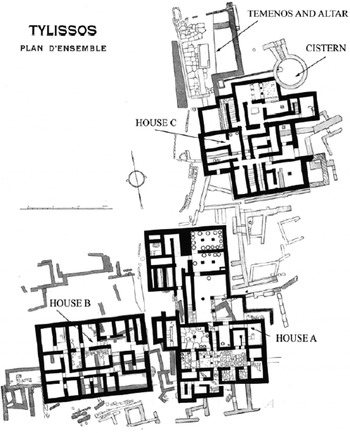
The territory defined by these memorable boundariesFootnote 63 is more generous in size than one would expect considering the importance of Classical Tylissos, especially in its northeastern extent which seems to extend northwards. Interestingly, the more important Neopalatial (Middle Minoan IIIB to Late Minoan I) Minoan Tylissos may also be of a comparable size (see fig. 6). Indeed, the presence of the Neopalatial Minoan villa at SklavokambosFootnote 64 and the surrounding Minoan settlement (possibly predating the villa) still visible todayFootnote 65 at the entrance to the plain of Gonies, as one comes from Tylissos through the easily defensible gorge of Gonies (Goniano faraggi – Ayia Anna), indicates that the western border of TylissosFootnote 66 was somewhere in that gorge at the start of the Neopalatial period. The northwestern border of Minoan Tylissos would possibly have been the very prominent peak sanctuary of Pyrgos that was founded some time in early Middle Minoan times and lasted until at least early Neopalatial times (figure 5). Interestingly, the Pyrgos peak sanctuary building was used for a sanctuary in the fourth century BC, a century after our inscriptions, where some Attic and Atticising pottery was found.Footnote 67 I have argued elsewhere that peak sanctuaries, much like some later sanctuaries, acted as border-markers. They were neutral, strategic territories which, much like Classical sanctuaries located elsewhere, were arena for local and regional competition.Footnote 68 As for the eastern border of Tylissos, the relative sizes of Knossos and Tylissos in the Neopalatial period would place a natural border much closer to Tylissos than to Knossos, and, therefore, quite close to the ‘river’ which is the best defensible position closer to Tylissos and is an obvious marker since it flows from the Gonies gorge, as described in the fifth-century BC treaty above. To the northeast, the border was also similar, if what Mariani excavated at the end of the nineteenth century in Marathoképhala, just above the location we reconstruct as Leukoporon, was indeed a villa (Hazzidakis (Reference Hazzidakis1934), 73) and thus belonged to a different Minoan state.
Map showing the reconstructed Minoan boundaries of Tylissos.

Plan of the excavations at Tylissos (after Hazzidakis Reference Hazzidakis1934).

Tylissos as a settlement continued to exist after the end of LM I since significant LM III (both IIIB and IIIC), ‘sub-Minoan’ and Geometric deposits were found in the same area with the Minoan villa, as Kanta reports.Footnote 69 In LM IIIB (Mycenaean times) the Tylissos villa continued to be used and according to Hayden there was also a stoa and a central building (Hayden (Reference Hayden1981) 52–5). Moreover we do have extensive reference to Tu-ri-so in the Linear B tablets of Knossos, implying that Tylissos found itself within the Knossian borders (Bennet (Reference Bennet1985) 245).
After the destruction of the palace of Knossos and in the Late Minoan IIIC we do know of at least one refuge settlement in Kastrokephala (Kanta (Reference Kanta, Deger-Jalkotzy and Zavadil2003) 167–82, Kanta and Karetsou (Reference Kanta, Karetsou, Deger-Jalkotzy and Zavadil2003) 145–65) located at the northernmost border that we reconstructed for Classical Tylissos (figure 3, opposite Λᾶος) and possibly defining that border in the LM IIIC.
Although we do know of Tylissos' existence in the subsequent periods, we cannot know its extent due to the small number of reports from the area. Very little has been reported about the archaic Tylissos, though judging by the sketchy reports of the early excavators on non-Minoan periods this is hardly surprising.
Even if the borders of Tylissos changed in the intervening periods (between LM IIIC to the fifth century), as they certainly did in the third or second centuries BC when Tylissos became very unimportant or possibly was overrun, again, by Knossos, it is noteworthy that the borders overlapped in two and perhaps three significant periods of Tylissos' history. Argos moreover seems to play a significant role in Tylissian history dominating it certainly in the middle of the fifth but possibly also all through the fourth century.
A third case of possible overlap appears in the twentieth century when borders of the koinotis of Tylissos, as we see in figure 7, also largely coincided with the Classical borders. The map shows the official borders imposed by the state. The locals often dispute the west side of the border and use the principle: ‘whatever we see on the mountain is ours and what the Tylissians see is theirs’, implying a border running through the Minoan peak sanctuaryFootnote 70 itself rather than below it as the map shows. This would constitute only a minor difference in the borders of a desolate area with only a few affected stakeholders. In the southwest, where the church of Agia Anna is located, the koinotis border is well defined. The Classical southwest border in the river bed is hard to define without knowing with certainty the location of the Archós plot. The same is the case with the northeast border, which, depending on the location of Agathoia, may have been more extensive in the Classical period. Indeed, the northeast end of the border may be the only clear deviation of the Classical border from that of the twentieth century koinotis. But these differences are neither significant, nor constitute any major change, whether geopolitical, financial or cultural. The koinotis borders are interestingly still used today by the locals;Footnote 71 this, despite the fact that the koinotites borders have now been abolished for two decades, and despite the fact that inhabitants from neighbouring villages have bought large swathes of land in the old koinotis area of Gonies.
Map showing the old koinotis boundaries for the villages of Tylissos, Moni and Kamari (Information taken from the ESY map).

This detail casts light on the Argive approach to imposing borders, as well as to possible practices of using ‘ancient’ borders to delineate a sphere of influence during the late Classical period: although imposed borders are often random and do not necessarily follow natural boundaries, those discussed here have certainly made full use of the natural relief and have used defensible positions, such as mountains, rivers and possibly a rock.Footnote 72 Moreover, the borders set out here overlap with the extrapolated borders of Minoan and mid-twentieth-century Tylissos, and, in this treaty, thanks to their Argive allies, are probably reinstated to the chagrin of the Knossians. Despite the overarching status of the Argives, the terms stated are not extraordinary or irrational; they are against a free rein for Knossos and in favour of both Tylissos and, directly or indirectly, Argos. This treaty shows both an experienced hand in crafting lasting treaties as well as a sense of pragmatism in matters concerning the local history and habits.
The reconstructed border, a piece of intangible heritage, can illuminate other intangible aspects of ancient life given the importance of borders, highlighted above, and considering the various activities they can affect. Although the pastoralist movement patternsFootnote 73 may occasionally ignore borders,Footnote 74 many other crucial activities such as trade and exchange, war and defence, administration and bureaucracy are all regulated by them.
In the case presented here the inscriptions, archaeology and geography of the area of Tylissos illuminate the borders of the town in the Classical period. What we know about borders however, together with the reconstructed borders of the town may lead us to further reconstructions on the intangible, no matter how small. One such avenue for further research may be the fact that in three periods of Tylissian history the borders do not seem to have dramatically changed, thus crafting specific identities, consciences and affiliations of the Tylissians with their landscape. Without making a blanket statement about continuity, and without claiming that there were indeed stable borders in Tylissian history, the conscience that these lands are ‘ours’ and these beyond are ‘theirs’, even within the confines of larger political entities such as the modern Greek state, is not something that was shaped overnight. And conversely, the importance of borders may also have been a reason behind the long lasting importance of specific locales such as the peak sanctuary turned into a Classical sanctuary, or the importance of a particular plot, the separating character of a river, or the conscious prominence of a visible feature in the landscape.
Appendix
Excerpt from the mini epos of Anogeia (end of nineteenth century AD) as transcribed by G. Kounalis, September 1977, Foni ton Anogeion 58. This excerpt is a good demonstration of how boundaries, although intangible, are memorised in oral culture; most people who know this poem have never seen it written. Poems like this traditional 15-syllable verse, common in medieval and modern Cretan poetry, are effective public learning and mnemonic mechanisms, employed not only to preserve the information but also to make a public statement of authority in the area. Although this poem refers to the borders of Anogeia which are not considered in this study (though they are in the same geographic area), there are a several interesting parallels with the borders referred to above.

Note: the limits of the koinotis of Anogeia in the 1950s are largely the same as those described in the nineteenth-century poem above. The reader will notice the great detail of the delineation of borders in the southern end of the koinotis, and a mere reference to the borders of other koinotites, i.e. Gonies, Sisarcha, Kamariotis, Livada, Axos and Zoniana which have not been in doubt and are referred to summarily here. The point of the poem is to explain the borders of Anogeia with the koinotites to its south, and hence the greater detail there.