Refine search
Actions for selected content:
86 results
Evolution of debris cover over glaciers in the Central Andes (1985–2024)
-
- Journal:
- Journal of Glaciology / Volume 72 / 2026
- Published online by Cambridge University Press:
- 15 October 2026, e105
-
- Article
-
- You have access
- Open access
- HTML
- Export citation
-
Glaciers are critical freshwater reservoirs in the Central Andes. Although supraglacial debris covers over 40% of the glacierised area in the Atlantic basins, the long-term surface evolution of debris-covered glaciers remains poorly constrained. In this study, we quantify glacier surface evolution over four decades (1985–2024) for 229 debris-covered glaciers across five major Atlantic basins in the Central Andes. Using ANDESMAG, a Python-based decision-tree algorithm employing spectral thresholds, we analysed more than 60 000 Landsat and Sentinel-2 image tiles in Google Earth Engine. Overall, debris-covered area increased by
 $20\pm11$% and debris-emergence elevation rose by
 $122\pm99$ m, while snowline altitude at the end of summer increased by
 $181\pm91$ m and snow-cover ratio declined by
 $9\pm11$%. Most of these changes occurred after 2009, during the Central Andes Megadrought, and correlated more strongly with declining precipitation than with rising air temperature. Our open-access workflow, which achieves a classification accuracy of 94%, provides the first annual regional assessment of debris-covered glacier surface evolution in the Central Andes of Argentina. Our results highlight the vulnerability of debris-covered glaciers to ongoing climate change and offer a transferable tool applicable to glacierised mountain regions worldwide.
Locating a complex subglacial drainage network using seismic arrays on Glacier d’Otemma, Switzerland
-
- Journal:
- Journal of Glaciology / Volume 72 / 2026
- Published online by Cambridge University Press:
- 04 August 2026, e85
-
- Article
-
- You have access
- Open access
- HTML
- Export citation
Multi-decadal observations of glacier thinning from airborne laser altimetry reveal accelerating mass loss in Alaskan National Parks
-
- Journal:
- Journal of Glaciology / Volume 72 / 2026
- Published online by Cambridge University Press:
- 30 July 2026, e83
-
- Article
-
- You have access
- Open access
- HTML
- Export citation
-
We use all 27 years of airborne laser altimetry from the University of Alaska Fairbanks to quantify changes in surface elevation across 205 large glaciers that together represent 56% of the glacier area in Alaska and adjacent Canada, including 71% of the ice cover in Alaska’s National Parks. We reprocessed lidar point clouds into a homogenized publicly available 2.5 m digital elevation model (DEM) archive, implemented a new double-differencing approach to incorporate partially overlapping surveys and derived elevation change in 10 m elevation bins to assess glacier-wide mass balance for all surveyed epochs on each glacier. The resulting mean balance rate for all measured glaciers shows statistically significant acceleration of mass loss, ranging from
 $-0.83 \pm{0.13} \,\, \text{m}\,\, \text{w.e.}\ \text{a}^{-1}$ before 2008 to
 $-1.16 \pm{0.08} \,\, \text{m}\,\, \text{w.e.}\ \text{a}^{-1}$ thereafter. Extrapolating measured thinning rates from the latter period (2008–22) to unsurveyed glaciers suggests that Alaskan National Parks are losing 33.74
 $\text{Gt a}^{-1}$ of ice, approximately one third of all estimated losses in the region. We use case studies of several prominent glaciers to show how this sustained acceleration of mass loss, which is consistent with recent global assessments, is having direct impacts on visitors, land managers, ecosystems and geohazards in the National Parks.

Projections of 21st-century glacier change in Alaska’s national parks calibrated against spatially distributed elevation change observations
- Part of
-
- Journal:
- Journal of Glaciology / Volume 72 / 2026
- Published online by Cambridge University Press:
- 24 July 2026, e72
-
- Article
-
- You have access
- Open access
- HTML
- Export citation
-
Despite advances in global glacier modeling, notable uncertainties remain in part due to model overparameterization. We develop a novel Bayesian inference framework to calibrate the Python Glacier Evolution Model (PyGEM) against spatially distributed surface elevation change data. The utility of this framework is demonstrated using a 1994–2021 airborne laser altimetry record for 185 glaciers in Alaska, which altogether represent over half of the region’s glacier area. Calibration against these data reduces parameter uncertainty by 5–18% and lowers the mean absolute error in hindcast surface elevation change by 0.18 m a−1 (15% compared to prior models). Model projections for these 185 glaciers estimate mass loss ranging from 43
 $ \pm $ 17% to 67
 $ \pm $ 27% depending on the emissions scenario. The projections highlight considerable subregional variability ranging from a median glacier mass loss of 57–99% by the end of the century for Lake Clark, Denali, Kenai Fjords, and Glacier Bay national parks, compared to 28–51% lost for Wrangell–St. Elias National Park and Preserve. As additional spatially distributed elevation change datasets become available in Alaska and elsewhere, the framework presented here is well suited to further refine model calibration and improve projections, while remaining flexible to incorporate additional glacier change observations as they become available.


Geodetic glacier mass loss in the Canadian Arctic Archipelago: Photogrammetric analysis of historical aerial photographs (1958–2023)
-
- Journal:
- Journal of Glaciology / Volume 72 / 2026
- Published online by Cambridge University Press:
- 22 June 2026, e64
-
- Article
-
- You have access
- Open access
- HTML
- Export citation
-
The Canadian Arctic Archipelago constitutes a primary source of contemporary sea-level rise from glaciers and ice caps, yet glacier-scale, multi-decadal records on Baffin and Bylot Islands remain limited. This study reconstructs long-term elevation and volume change for seven glaciers, six in Auyuittuq National Park and one in Sirmilik National Park, using 1958/59 imagery from the Canadian National Air Photo Library. Historical digital elevation models were reconstructed using TanDEM-X for vertical ground control and PlanetScope imagery for horizontal ground control, with ArcticDEM supporting final co-registration and on-ice elevation-change analysis. Uncertainty was quantified from stable-terrain residuals, with normalized median absolute deviation values of
 $2.08$–
 $4.07$ m. Specific geodetic mass balances for the Auyuittuq glaciers ranged from
 $-0.22$ to
 $-0.35$ m w.e. a
 $^{-1}$ for 1959–2021/22, while Fountain Glacier averaged
 $-0.35$ m w.e. a
 $^{-1}$ for 1958–2022. Cumulative ice-volume change totalled
 $-4.76 \times 10^{9}$ m
 $^{3}$, equivalent to
 $-4.05 \pm 0.29$ Gt. Auyuittuq glaciers shortened by
 $7$–
 $16\%$ and lost
 $9$–
 $28\%$ of their area. Spatial variability reflects glacier hypsometry, with lower-elevation glacier areas showing greater sensitivity to atmospheric warming. These results provide new glacier-scale geodetic mass-balance estimates for the Canadian Arctic Archipelago based on archival photogrammetry, although density assumptions that omit firn evolution require further refinement when estimating mass change.


Advance and thickening of the tidewater outlet glacier Eqalorutsit Kangilliit Sermiat surrounded by the thinning southern Greenland ice sheet
-
- Journal:
- Journal of Glaciology / Volume 72 / 2026
- Published online by Cambridge University Press:
- 08 June 2026, e54
-
- Article
-
- You have access
- Open access
- HTML
- Export citation
Toward improved comparability of glacier mass-balance estimates: Challenges and recommendations
- Part of
-
- Journal:
- Journal of Glaciology / Volume 72 / 2026
- Published online by Cambridge University Press:
- 05 May 2026, e49
-
- Article
-
- You have access
- Open access
- HTML
- Export citation
Helm Glacier projected to vanish within a decade
- Part of
-
- Journal:
- Annals of Glaciology / Volume 67 / 2026
- Published online by Cambridge University Press:
- 24 March 2026, e13
-
- Article
-
- You have access
- Open access
- HTML
- Export citation
-
Helm Glacier is a World Glacier Monitoring Service reference glacier and is one of three glaciers in Western Canada with a mass balance record which exceeds 40 years. An ice-penetrating radar survey reveals a mean and maximum ice thickness of 13.0 and
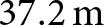 $37.2\,\mathrm{m}$, respectively. We combine ice thickness data and altimetric data from repeat LiDAR surveys to project ice disappearance. We use simple extrapolation and a multivariate linear regression to predict surface elevation change based on incoming shortwave radiation, end-of-winter snow depth, positive degree days, slope and aspect. Both approaches project the disappearance of Helm Glacier by 2035. We estimate that Helm Glacier has a current mass balance sensitivity to temperature of
 ${\mathrm C}_{\mathrm T}=-0.58\,{\mathrm m\boldsymbol\,\mathrm w.\mathrm e.\boldsymbol\,\mathrm a}^{-1}\,^\circ\,\mathrm C^{-1}$, which is slightly less negative than the balance sensitivity of
 ${\mathrm C}_{\mathrm T}=-0.64\,{\mathrm m\boldsymbol\,\mathrm w.\mathrm e.\boldsymbol\,\mathrm a}^{-1}\,^\circ\,\mathrm C^{-1}$ derived from the in situ balance record. Helm Glacier is more than 4
 $\rm{^\circ}C$ out of balance with current climate conditions [2014–24].

ICESat-2 land ice products resolve Greenland and Antarctic ice-sheet height changes on seasonal to multiyear time scales
-
- Journal:
- Journal of Glaciology / Volume 72 / 2026
- Published online by Cambridge University Press:
- 24 March 2026, e63
-
- Article
-
- You have access
- Open access
- HTML
- Export citation
When has a glacier disappeared?
- Part of
-
- Journal:
- Annals of Glaciology / Volume 67 / 2026
- Published online by Cambridge University Press:
- 06 March 2026, e18
-
- Article
-
- You have access
- Open access
- HTML
- Export citation
Shifts in glacier dynamics during land-to-lake terminus transition in western Patagonia
-
- Journal:
- Journal of Glaciology / Volume 72 / 2026
- Published online by Cambridge University Press:
- 05 March 2026, e34
-
- Article
-
- You have access
- Open access
- HTML
- Export citation
From Snowferner to no ferner: The deglaciation of Zugspitzplatt
- Part of
-
- Journal:
- Annals of Glaciology / Volume 67 / 2026
- Published online by Cambridge University Press:
- 05 February 2026, e9
-
- Article
-
- You have access
- Open access
- HTML
- Export citation
Updating Norway’s glacial lake extents in 2023–2024 using Sentinel-1 & Sentinel-2 data and machine learning
-
- Journal:
- Journal of Glaciology / Volume 72 / 2026
- Published online by Cambridge University Press:
- 02 February 2026, e16
-
- Article
-
- You have access
- Open access
- HTML
- Export citation
The Sun is setting for the historic Sunlight Glacier, Absaroka Mountains, Wyoming, USA
- Part of
-
- Journal:
- Annals of Glaciology / Volume 67 / 2026
- Published online by Cambridge University Press:
- 02 February 2026, e7
-
- Article
-
- You have access
- Open access
- HTML
- Export citation
The archaeology of glaciers and ice patches: The intersection of climate change, glacier retreat and cultural heritage
- Part of
-
- Journal:
- Annals of Glaciology / Volume 67 / 2026
- Published online by Cambridge University Press:
- 21 January 2026, e5
-
- Article
-
- You have access
- Open access
- HTML
- Export citation
Unprecedented mass loss of Aldegondabreen, central Spitsbergen, Svalbard
-
- Journal:
- Journal of Glaciology / Volume 72 / 2026
- Published online by Cambridge University Press:
- 05 January 2026, e3
-
- Article
-
- You have access
- Open access
- HTML
- Export citation
Vanishing of the Glacier Yanamarey, one of the four glaciers with in situ measurements in the Cordillera Blanca, Peru
- Part of
-
- Journal:
- Annals of Glaciology / Volume 67 / 2026
- Published online by Cambridge University Press:
- 22 December 2025, e8
-
- Article
-
- You have access
- Open access
- HTML
- Export citation
QFuego-Patagonia: A comprehensive glacier-related dataset for Patagonia and Tierra del Fuego, South America
- Part of
-
- Journal:
- Journal of Glaciology / Volume 72 / 2026
- Published online by Cambridge University Press:
- 27 November 2025, e14
-
- Article
-
- You have access
- Open access
- HTML
- Export citation
High-frequency image analysis of calving activity and styles at Hansbreen, Svalbard
-
- Journal:
- Journal of Glaciology / Volume 71 / 2025
- Published online by Cambridge University Press:
- 19 November 2025, e125
-
- Article
-
- You have access
- Open access
- HTML
- Export citation
Vanished glaciers of the Swiss Alps: An inventory-based assessment from 1973 to 2016
- Part of
-
- Journal:
- Annals of Glaciology / Volume 66 / 2025
- Published online by Cambridge University Press:
- 14 November 2025, e33
-
- Article
-
- You have access
- Open access
- HTML
- Export citation