“Although there are various exceptions,” the authors claim, “a general rule is that aggression and violence increase as one moves closer to the equator, which suggests the important role of climate differences” (Abstract). As the authors acknowledge, there are problems in using cross-cultural (or cross-sectional) data on climate, violence, and civil conflict because “[d]ifferences between countries (e.g., historical, economic, political variables) are exceptionally difficult to disentangle from climate differences” (sect. 1, para. 5; see also Burke et al. [Reference Burke, Hsiang and Miguel2015, p. 580]). In this case, however, one variable, the historical geography of colonialism and its effects on the distribution of fragile, postcolonial states in the 20th century, has such a weighty confounding effect that latitudinal data on rates of conflict and violence cannot be accepted as evidence for the authors' argument.
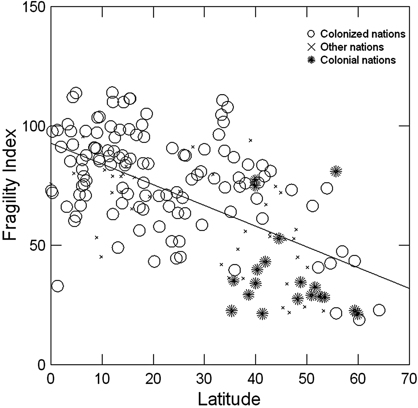
As Figure 1 reveals, most colonized nations that achieved their independence between 1900 and the present (circle icons) are located in the warmer, lower latitudes between 0o and about 35o. In contrast, the nations that colonized them (star icons) occupy the higher, cooler latitudes, between 35o and 60o (p < .0001).
Figure 1.
Colonial status and 2016 fragility of 178 nations by capital city latitude. A high fragility index denotes high fragility.
Because postcolonial nations are structurally more fractured than colonizing nations, and their governmental institutions less equipped to control crime or preempt civil conflict, it follows that aggression and violence will increase as one moves closer to the equator. Prior to imperial control, postcolonial nations existed as autonomous indigenous polities, most of them periodically or permanently at war with their neighbors. Colonization, however, abruptly grouped these communities together as a single polity – a “colony” – within borders arbitrarily defined by accidents of geography and history (Roscoe Reference Roscoe and Carballo2013; Reference Roscoe2014; see also Kaplan Reference Kaplan2008). With the collapse of empires in the last century, these artificially aggregated communities were then pronounced autonomous “nation-states” by fiat, and expected rapidly and without rancor to lay aside the enmities that had divided them just a few decades to a century or so previously.
In most cases, the colonial period was too brief to erase these divisions. In contrast to the more “organic” unity enjoyed by the nations that colonized them, postcolonial states comprise a set of political communities each of which still envisions itself to varying degrees as separate in identity and independent of the others. In many postcolonial nations, the task of managing these political fault lines was complicated by the egalitarian political orientation of their component communities, which interfaced poorly with the hierarchical, Euro-American governance structures they inherited (Strathern Reference Strathern1993, p. 719). To add to the difficulties of unification, the communities originally corralled into a postcolonial nation seldom spoke a single language. Depending on definitions, for instance, the number of languages in Papua New Guinea is at least 600; the Democratic Republic of the Congo has at least 215.
Given an inverse latitudinal gradient between the occurrence of stable colonizer nations and weak postcolonial ones, we should therefore expect a similar gradient in national fragility, a relationship empirically confirmed by the Fragile States Index (Fund for Peace 2016) (Fig. 1, regression line; r = −0.605). Because postcolonial nations are structurally more fractured than colonizing nations, and their governmental institutions less equipped to control crime or preempt civil conflict, it follows that aggression and violence will increase as one moves closer to the equator.
It may be, as the authors claim, that temperature affects human aggression and violence, but to use latitudinal data to justify a hypothesis that inhabitants of warmer climates are more present than future oriented and less focused on self-control than those in colder climates ignores the historical role of the latter in generating weak systems of sociopolitical control in the former. Worse, it runs the danger of unjustly stereotyping the populations of postcolonial nations.







“Although there are various exceptions,” the authors claim, “a general rule is that aggression and violence increase as one moves closer to the equator, which suggests the important role of climate differences” (Abstract). As the authors acknowledge, there are problems in using cross-cultural (or cross-sectional) data on climate, violence, and civil conflict because “[d]ifferences between countries (e.g., historical, economic, political variables) are exceptionally difficult to disentangle from climate differences” (sect. 1, para. 5; see also Burke et al. [Reference Burke, Hsiang and Miguel2015, p. 580]). In this case, however, one variable, the historical geography of colonialism and its effects on the distribution of fragile, postcolonial states in the 20th century, has such a weighty confounding effect that latitudinal data on rates of conflict and violence cannot be accepted as evidence for the authors' argument.
As Figure 1 reveals, most colonized nations that achieved their independence between 1900 and the present (circle icons) are located in the warmer, lower latitudes between 0o and about 35o. In contrast, the nations that colonized them (star icons) occupy the higher, cooler latitudes, between 35o and 60o (p < .0001).
Colonial status and 2016 fragility of 178 nations by capital city latitude. A high fragility index denotes high fragility.
Because postcolonial nations are structurally more fractured than colonizing nations, and their governmental institutions less equipped to control crime or preempt civil conflict, it follows that aggression and violence will increase as one moves closer to the equator. Prior to imperial control, postcolonial nations existed as autonomous indigenous polities, most of them periodically or permanently at war with their neighbors. Colonization, however, abruptly grouped these communities together as a single polity – a “colony” – within borders arbitrarily defined by accidents of geography and history (Roscoe Reference Roscoe and Carballo2013; Reference Roscoe2014; see also Kaplan Reference Kaplan2008). With the collapse of empires in the last century, these artificially aggregated communities were then pronounced autonomous “nation-states” by fiat, and expected rapidly and without rancor to lay aside the enmities that had divided them just a few decades to a century or so previously.
In most cases, the colonial period was too brief to erase these divisions. In contrast to the more “organic” unity enjoyed by the nations that colonized them, postcolonial states comprise a set of political communities each of which still envisions itself to varying degrees as separate in identity and independent of the others. In many postcolonial nations, the task of managing these political fault lines was complicated by the egalitarian political orientation of their component communities, which interfaced poorly with the hierarchical, Euro-American governance structures they inherited (Strathern Reference Strathern1993, p. 719). To add to the difficulties of unification, the communities originally corralled into a postcolonial nation seldom spoke a single language. Depending on definitions, for instance, the number of languages in Papua New Guinea is at least 600; the Democratic Republic of the Congo has at least 215.
Given an inverse latitudinal gradient between the occurrence of stable colonizer nations and weak postcolonial ones, we should therefore expect a similar gradient in national fragility, a relationship empirically confirmed by the Fragile States Index (Fund for Peace 2016) (Fig. 1, regression line; r = −0.605). Because postcolonial nations are structurally more fractured than colonizing nations, and their governmental institutions less equipped to control crime or preempt civil conflict, it follows that aggression and violence will increase as one moves closer to the equator.
It may be, as the authors claim, that temperature affects human aggression and violence, but to use latitudinal data to justify a hypothesis that inhabitants of warmer climates are more present than future oriented and less focused on self-control than those in colder climates ignores the historical role of the latter in generating weak systems of sociopolitical control in the former. Worse, it runs the danger of unjustly stereotyping the populations of postcolonial nations.